Precipitation Characteristic Analysis of the Zhoushan Archipelago: From the View of MSWEP and Rainfall Merging
Abstract
:1. Introduction
2. Study Area and Data
2.1. Study Area
2.2. Rainfall Data
2.2.1. Rain Gauge Observations
2.2.2. MSWEP Data
3. Methodology
3.1. Precipitation Evaluation Indices
3.2. Rainfall Merging Algorithms
4. Results and Analysis
4.1. Precipitation Performance at Different Time Scales
4.1.1. Accuracy of Daily Rainfall
4.1.2. Accuracy of Monthly Rainfall
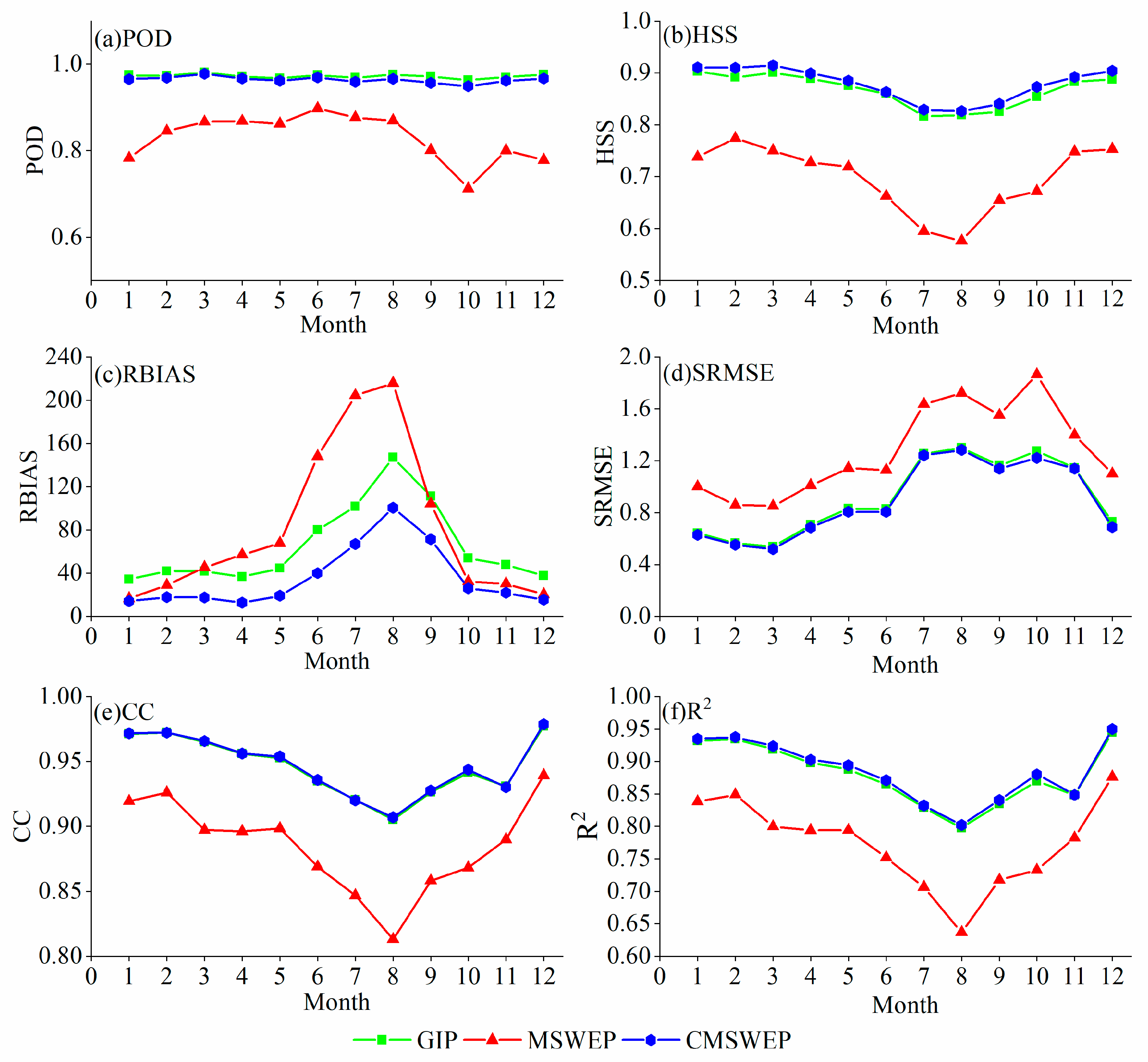
4.1.3. Seasonal Changes of the Accuracy Statistics
4.2. Comparison of Rainfall Spatial Distribution
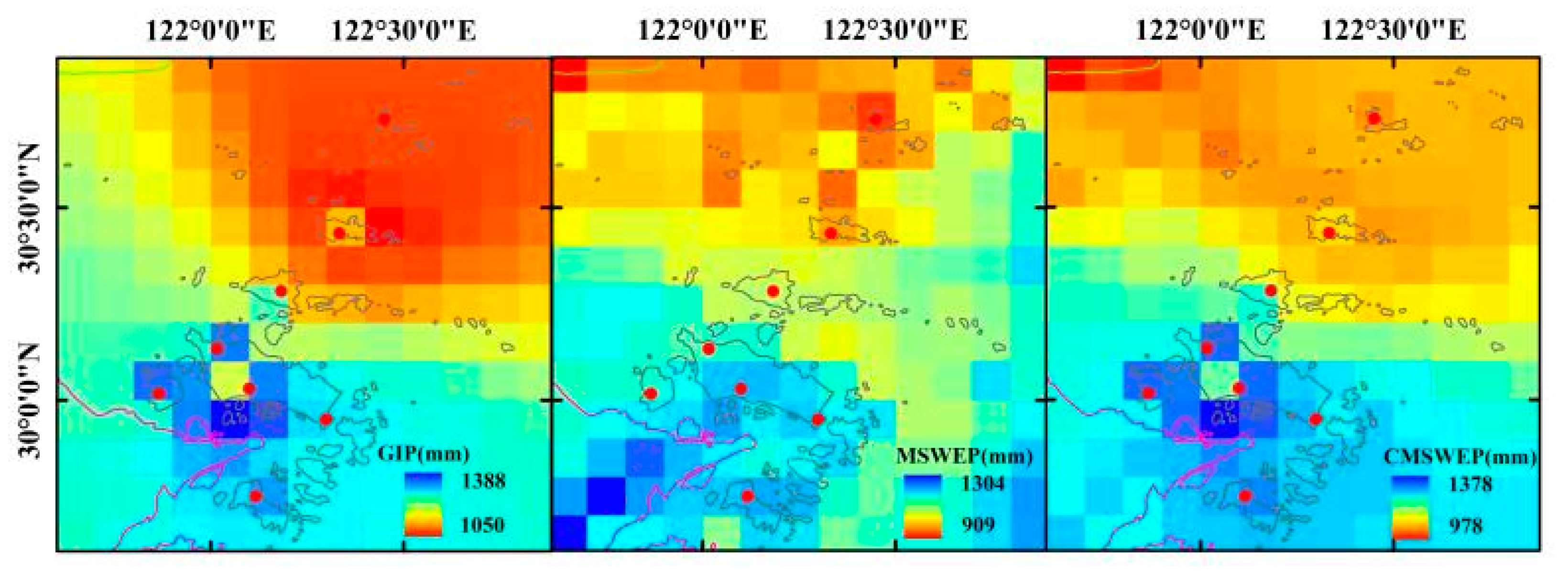
4.2.1. Annual Rainfall
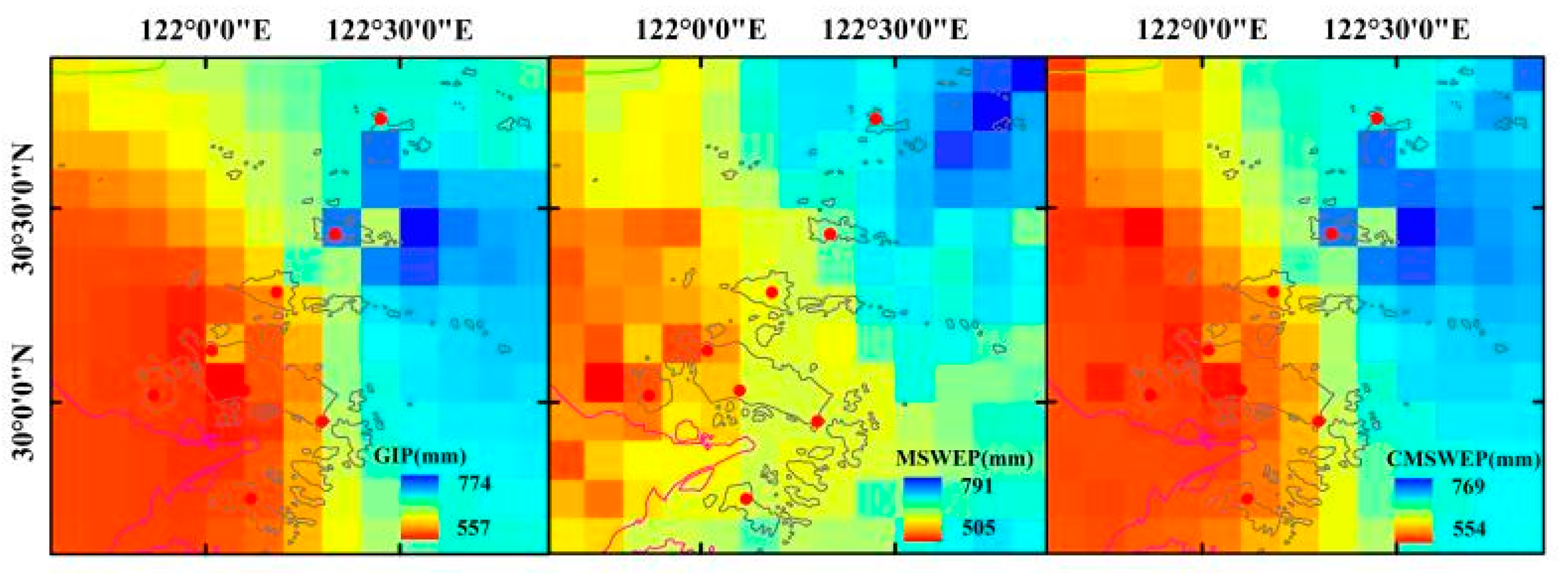
4.2.2. Flood Season Rainfall
4.2.3. Accumulated Days with Daily Rainfall Exceeding 50 mm
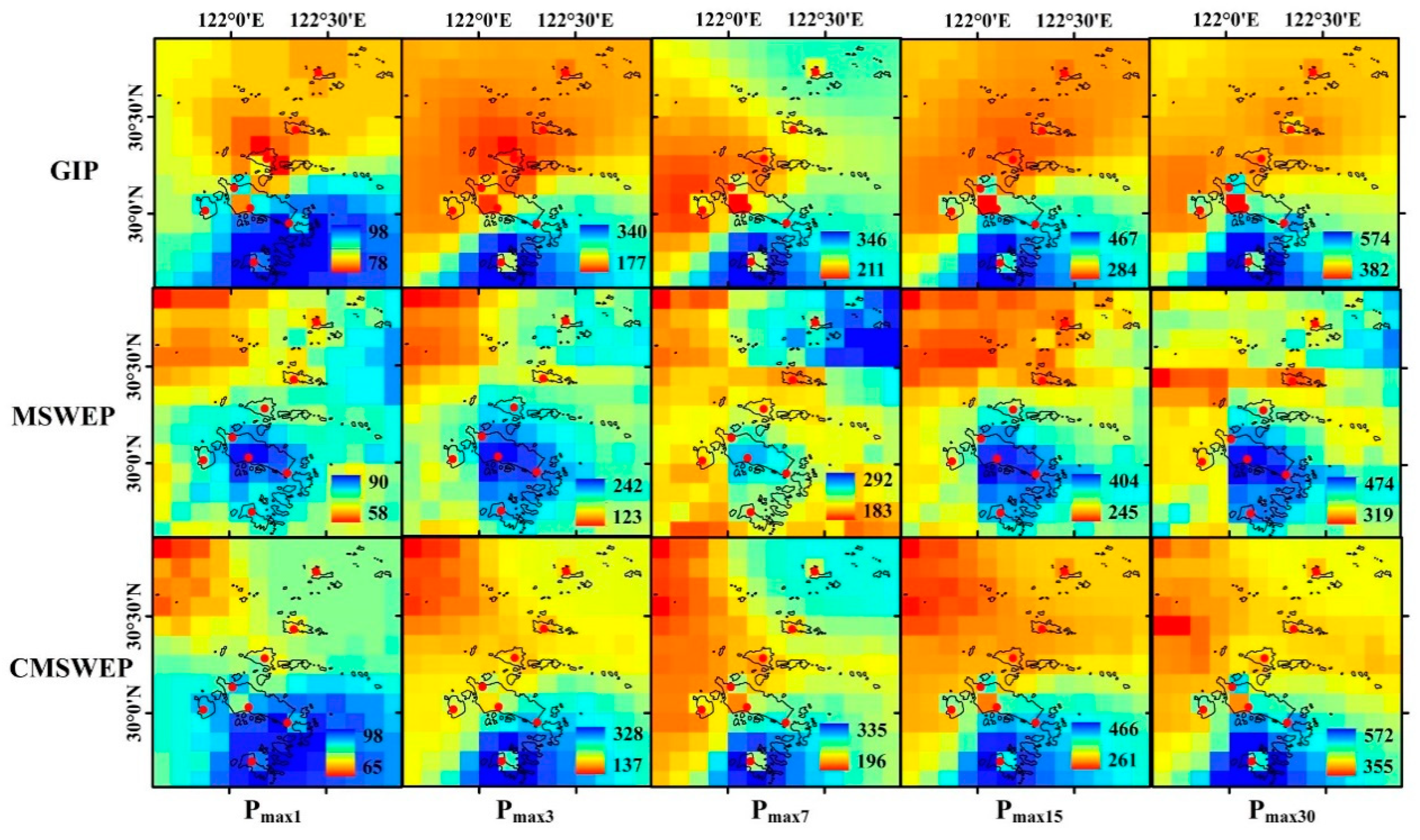
4.2.4. Maximum Rainfall of Different Duration
4.3. Analysis of Daily Rainfall Process
5. Discussion and Conclusions
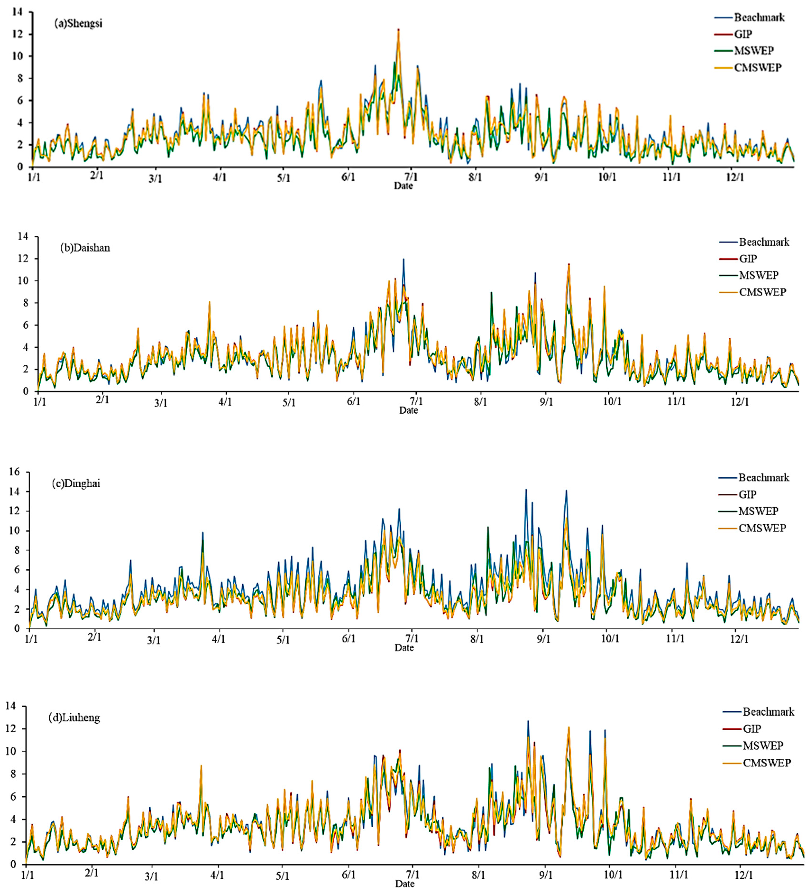
- The precipitation data CMSWEP by merging MSWEP with surface rainfall data not only has a significant improvement in accuracy compared with MSWEP, but also has a certain degree of improvement compared with the gauge interpolation data GIP. At the daily time scale, the advantage of CMSWEP over GIP is mainly shown in the comprehensive identification ability of the dry and wet state of daily rainfall.
- At the daily time scale, the accuracy indices of GIP, MSWEP, and CMSWEP have significant seasonal changes except POD. GIP and CMSWEP are significantly better than MSWEP in terms of accuracy indices in each month of the year. At the monthly scale, there are also certain seasonal changes for the accuracy indices of the three datasets, but they are obviously different from those at the daily scale.
- For various precipitation elements including multi-year mean precipitation, multi-year mean flood season precipitation, cumulative rainstorm days, and maximum precipitation, MSWEP and CMSWEP can demonstrate the spatial distribution characteristics that sparse surface rainfall data cannot describe. For various precipitation elements of MSWEP and GIP, the location of the center with high value is not completely consistent. Meanwhile, the spatial distribution is relatively smooth with GIP, while MSWEP shows more details. CMSWEP has spatial structure characteristics of both GIP and MSWEP.
- Although the spatial distribution characteristics of precipitation statistics such as annual precipitation and extreme precipitation in Zhoushan Archipelago are displayed by ARCGIS in this paper, the precipitation statistics indicators are not further processed. In order to describe the precipitation characteristics of Zhoushan Archipelago in more detail, the authors will use copulas non-parametric statistical method to conduct on the spatial distribution of the probability index of regional rainfall height [33,34,35,36]. At the same time, the time resolution of MSWEP data is 3 h, but the accuracy below the daily time scale of MSWEP data has not been evaluated in this paper. In the future, the accuracy of MSWEP below the daily time scale will be further analyzed, so as to explore the ability of MSWEP to identify short-duration rainfall and rainfall diurnal variation. Despite of the high spatial resolution of MSWEP, the merging of the data with surface rain gauge data is still faced with the problem of space scale transformation. Thus, in future the merging of different precipitation data will be realized on the basis of spatial downscaling of MSWEP, and the effect of the data spatial resolution on estimation results will be analyzed. We will extend this study from the Zhoushan Archipelago to other coastal or inland areas lacking in surface rainfall observations.
Author Contributions
Funding
Acknowledgments
Conflicts of Interest
Abbreviations
| CC | Correlation Coefficient |
| CMAP | Climate Prediction Center (CPC) Merged Analysis |
| CMSWEP | Combined MSWEP |
| CMORPH | CPC MORPHing technique |
| CPC | Climate Prediction Center |
| FH | Frequency of Hit |
| GIP | Gauge-Interpolated Precipitation |
| GPCP | Global Precipitation Climatology Project |
| GPM | Global Precipitation Measurement |
| GSMaP | Global Satellite Mapping of Precipitation |
| GSMaP-MVK | GSMaP Moving Vector with Kalman-filter |
| HSS | Heidke’Skill Score |
| IMERG | Integrated Multi-satellite Retrievals |
| MSWEP | Multi-Source Weighted-Ensemble Precipitation |
| PERSIANN | Precipitation Estimation from Remotely Sensed Information using Artificial Neural Networks |
| PERSIANN-CDR | PERSIANN-Climate Data Record |
| POD | Probability of Detection |
| R2 | Coefficient of Determination |
| RBIAS | Relative Bias |
| SRMSE | Standardized Root Mean Square Error |
| TRMM | Tropical Rainfall Measuring Mission |
| TRMM 3B42 | Tropical Rainfall Measuring Mission 3B42 |
| TMPA 3B42V7 | TRMM Multi-satellite Precipitation Analysis 3B42V7 |
References
- Andreas, F.; Prein, A.G. Impacts of uncertainties in European gridded precipitation observations on regional climate analysis. Int. J. Climatol. 2017, 37, 305–327. [Google Scholar]
- Hu, Q.; Li, Z.; Wang, L.; Huang, Y.; Wang, Y.; Li, L. Rainfall Spatial Estimations: A Review from Spatial Interpolation to Multi-Source Data Merging. Water 2019, 11, 579. [Google Scholar] [CrossRef] [Green Version]
- Adler, R.F.; Huffman, G.J.; Chang, A.; Ferraro, R.; Xie, P.P.; Janowiak, J.; Gruber, A. The version-2 global precipitation climatology project (GPCP) monthly precipitation analysis (1979–present). J. Hydrometeorol. 2003, 4, 1147–1167. [Google Scholar] [CrossRef]
- Xie, P.; Arkin, P.A. Global precipitation: A 17-year monthly analysis based on gauge observations, satellite estimates, and numerical model outputs. Am. Meteorol. Soc. 1997, 78, 2539–2558. [Google Scholar] [CrossRef]
- Huffman, G.J.; Bolvin, D.T.; Nelkin, E.J.; Wolff, D.B.; Adler, R.F.; Gu, G.; Hong, Y.; Bowman, K.P.; Stocker, E.F. The TRMM Multisatellite Precipitation Analysis (TMPA): Quasi-Global, Multiyear, Combined-Sensor Precipitation Estimates at Fine Scales. J. Hydrometeorol. 2007, 8, 38–55. [Google Scholar] [CrossRef]
- Iguchi, T.; Kozu, T.; Kwiatkowski, J.; Meneghini, R.; Awaka, J.; Okamoto, K. A Kalman filter approach to the Global Satellite Mapping of Precipitation (GSMaP) from combined passive microwave and infrared radiometric data. J. Meteorol. Soc. Japan Ser. II 2009, 87A, 137–151. [Google Scholar]
- Huffman, G.J.; Bolvin, D.T.; Nelkin, E.J. Integrated Multi-satellite Retrievals for GPM (IMERG) technical documentation. NASA/GSFC Code 2015, 612, 2019. [Google Scholar]
- Beck, H.E.; Van Dijk, A.I.J.M.; Levizzani, V.; Schellekens, J.; Gonzalez Miralles, D.; Martens, B.; de Roo, A. MSWEP: 3-hourly 0.25° global gridded precipitation (1979–2015) by merging gauge, satellite, and reanalysis data. Hydrol. Earth Syst. Sci. 2017, 21, 589–615. [Google Scholar] [CrossRef] [Green Version]
- Beck, H.E.; Wood, E.F.; Pan, M. MSWEP V2 Global 3-Hourly 0.1° Precipitation: Methodology and Quantitative Assessment. Bull. Am. Meteorol. Soc. 2019, 100, 473–500. [Google Scholar] [CrossRef] [Green Version]
- Alijanian, M.; Rakhshandehroo, G.R.; Mishra, A.K.; Dehghani, M. Evaluation of satellite rainfall climatology using CMORPH, PERSIANN-CDR, PERSIANN, TRMM, MSWEP over Iran. Int. J. Climatol. 2017, 37, 4896–4914. [Google Scholar] [CrossRef]
- Nair, A.S.; Indu, J. Performance Assessment of Multi-Source Weighted-Ensemble Precipitation (MSWEP) Product over India. Climate 2017, 5, 2. [Google Scholar] [CrossRef]
- Awange, J.L.; Hu, K.X.; Khaki, M. The newly merged satellite remotely sensed, gauge and reanalysis-based Multi-Source Weighted-Ensemble Precipitation: Evaluation over Australia and Africa (1981–2016). Sci. Total Environ. 2019, 670, 448–465. [Google Scholar] [CrossRef] [PubMed]
- Deng, Y.; Jiang, W.G.; Wang, X.Y. Accuracy assessment of MSWEP over mainland China. Adv. Water Sci. 2018, 29, 455–464. [Google Scholar]
- Xu, Z.G.; Wu, Z.Y.; He, H. Evaluating the accuracy of MSWEP V2.1 and its performance for drought monitoring over mainland China. Atmos. Res. 2019, 226, 17–31. [Google Scholar] [CrossRef]
- Woldemeskel, F.M.; Sivakumar, B.; Sharma, A. merging gauge and satellite rainfall with specification of associated uncertainty across Australia. J. Hydrol. 2013, 499, 167–176. [Google Scholar] [CrossRef]
- Nerini, D.; Zulkafli, Z.; Wang, L.P.; Onof, C.; Buytaert, W.; Lavado-Casimiro, W.; Guyot, J.L. A comparative analysis of TRMM–rain gauge data merging techniques at the daily time scale for distributed rainfall–runoff modeling applications. J. Hydrometeorol. 2015, 16, 2153–2168. [Google Scholar] [CrossRef] [Green Version]
- Wang, Y.Y.; Guo, H.; Li, G.C. Precipitation estimation and analysis of the Three Gorges Dam region (1979–2014) by combining gauge measurements and MSWEP with generalized additive model. J. Geogr. Sci. 2017, 72, 1207–1220. [Google Scholar]
- Neil, D.B.; Barry, F.W.C.; Giorgio, G.; Joseph, H.A.G.; Serena, H.H.; Anthony, J.J.; Stefano, M.; Lachlan, T.H.N.; John, P.N.; Charles, P.; et al. Characterising performance of environmental models. Environ. Model. Softw. 2013, 40, 1–20. [Google Scholar]
- Dong, Z.L.; Bai, M.L.; Yi, N.N. Relation between Summer Rainfall in Inner Mongolia and Asian Zonal Circulation. J. Arid Meteorol. 2018, 36, 256–262. [Google Scholar]
- Yang, W.; Xu, M.; Zhou, S.W.; Luo, L.S. Spatial-Temporal Variation of Extreme Precipitation Events from June to July over Yangtze-Huaihe River Basin and the Circulation Anomalies. Plateau Meteorol. 2017, 36, 718–735. [Google Scholar]
- Jesse, D.B.; Patrick, N.B.; Ronald, H.W.; Darryn, W.W.; Frank, C.C. Evaluating methods for spatial mapping: Applications for estimating ozone concentrations across the contiguous United States. Environ. Technol. Innov. 2015, 3, 1–10. [Google Scholar]
- Benjamin, S.O.; Seaman, N.L. A simple scheme for objective analysis in curved flow. Mon. Weather Rev. 1985, 113, 1184–1198. [Google Scholar] [CrossRef] [Green Version]
- Zhang, C.; Sun, J.H.; Duan, W. Research on Cressman Interpolation using Surfer Software based on Precipitation data of Yunnan Regional Station. J. Chengdu Univ. Inf. Technol. 2018, 33, 84–90. [Google Scholar]
- Tian, Y.; Peters-Lidard, C.D. A global map of uncertainties in satellite-based precipitation measurements. Geophys. Res. Lett. 2010, 37. [Google Scholar] [CrossRef]
- Yong, B.; Wang, J.; Ren, L.; You, Y.; Xie, P.; Hong, Y. Evaluating four multisatellite precipitation estimates over the Diaoyu Islands during Typhoon seasons. J. Hydrometeorol. 2016, 17, 1623–1641. [Google Scholar] [CrossRef]
- Setiawati, M.D.; Miura, F. Evaluation of GSMaP Daily Rainfall Satellite Data for Flood Monitoring: Case Study—Kyushu Japan. J. Geosci. Environ. Prot. 2016, 4, 101. [Google Scholar] [CrossRef] [Green Version]
- Shen, Y.; Zhao, P.; Pan, Y.; Yu, J. A high spatiotemporal gauge-satellite merged precipitation analysis over China. J. Geophys. Res. Atmos. 2014, 119, 3063–3075. [Google Scholar] [CrossRef]
- Jongjin, B.; Jongmin, P.; Dongryeol, R.; Minha, C. Geospatial blending to improve spatial mapping of precipitation with high spatial resolution by merging satellite-based and ground-based data. Hydrol. Process. 2016, 30, 2789–2803. [Google Scholar] [CrossRef]
- Li, M.; Shao, Q. An improved statistical approach to merge satellite rainfall estimates and rain gauge data. J. Hydrol. 2010, 385, 51–64. [Google Scholar] [CrossRef]
- Renzullo, L.J. An Assessment of Statistically Blended Satellite-Gauge Precipitation Data for Daily Rainfall Analysis in Australia. Int. Symp. Remote Sens. Environ. 2015, 442–445. [Google Scholar]
- Rozante, J.R.; Moreira, D.S.; De Goncalves, L.G.G.; Vila, D.A. Combining TRMM and surface observations of precipitation: Technique and validation over South America. Weather Forecast. 2010, 25, 885–894. [Google Scholar] [CrossRef] [Green Version]
- Chappell, A.; Renzullo, L.J.; Raupach, T.H.; Haylock, M. Evaluating geostatistical methods of blending satellite and gauge data to estimate near real-time daily rainfall for Australia. J. Hydrol. 2013, 493, 105–114. [Google Scholar] [CrossRef]
- De Luca, D.L.; Biondi, D. Bivariate Return Period for Design Hyetograph and Relationship with T-Year Design Flood Peak. Water 2017, 9, 673. [Google Scholar] [CrossRef] [Green Version]
- Nelsen, R.B. An Introduction to Copulas, 1st ed.; Springer: New York, NY, USA, 1999. [Google Scholar]
- Yue, S.; Rasmussen, P. Bivariate frequency analysis: Discussion of some useful concepts in hydrological application. Hydrol. Process. 2002, 16, 2881–2898. [Google Scholar] [CrossRef]
- Volpi, E.; Fiori, A. Design event selection in bivariate hydrological frequency analysis. Hydrol. Earth Syst. Sci. 2012, 57, 1506–1515. [Google Scholar] [CrossRef]




| No. | Name | Type | Data Collection Periods | Longitude (°E) | Latitude (°N) | Annual Average Precipitation (mm) | Annual Precipitation Variation Range (mm) |
|---|---|---|---|---|---|---|---|
| 1 | Shengsi | WS | 1979–2015 | 122°27′E | 30°43′N | 1135.6 | 681.1–1459.4 |
| 2 | Qushan | RG | 1979–1984, 2007–2015 | 122°20′E | 30°26′N | 1042.0 | 621.3–1478.5 |
| 3 | Daishan | RG | 1979–1984, 2007–2015 | 122°11′E | 30°17′N | 1131.1 | 639.1–1782.5 |
| 4 | Dasha | RG | 1979–1984, 2007–2015 | 122°01′E | 30°08′N | 1194.7 | 668.2–1759.0 |
| 5 | Dinghai | WS | 1975–2015 | 122°05′E | 30°03′N | 1581.7 | 925.1–2139.3 |
| 6 | Jintang | RG | 1979–1984, 2007–2015 | 121°52′E | 30°01′N | 1220.2 | 674.7–1948.0 |
| 7 | Shenjiamen | RG | 1979–1984, 2007–2015 | 122°18′E | 29°57′N | 1277.2 | 744.6–1686.5 |
| 8 | Liuheng | RG | 1979–1984, 2007–2015 | 122°07′E | 29°45′N | 1275.6 | 729.4–1868.8 |
| Indices | ||||||||
|---|---|---|---|---|---|---|---|---|
| Rainfall Datasets | POD | FH | HSS | RBIAS | SRMSE | RMSE (mm) | R2 | CC |
| GIP | 0.97 | 0.80 | 0.82 | 8.12 | 1.049 | 3.49 | 0.862 | 0.929 |
| MSWEP | 0.84 | 0.79 | 0.70 | 10.15 | 1.435 | 4.77 | 0.743 | 0.864 |
| CMSWEP | 0.96 | 0.89 | 0.88 | 4.42 | 1.026 | 3.41 | 0.868 | 0.933 |
| Indices | |||||
|---|---|---|---|---|---|
| Rainfall Datasets | RBIAS | RMSE (mm) | SRMSE | R2 | CC |
| GIP | 0.57 | 23.89 | 0.236 | 0.879 | 0.944 |
| MSWEP | −0.19 | 26.67 | 0.263 | 0.880 | 0.939 |
| CMSWEP | 0.36 | 22.93 | 0.227 | 0.894 | 0.948 |
| Island | Land Area (km2) | Population (person) | Data | Flood Season Precipitation (mm) | Mean Annual Precipitation (mm) |
|---|---|---|---|---|---|
| Zhoushan Island | 486.2 | 489,509 | GIP | 706.9 | 1278.5 |
| MSWEP | 660.0 | 1169.1 | |||
| CMSWEP | 705.6 | 1271.6 | |||
| Daishan Island | 105.0 | 103,396 | GIP | 644.5 | 1179.7 |
| MSWEP | 606.1 | 1072.6 | |||
| CMSWEP | 641.8 | 1168.8 | |||
| Liuheng Island | 93.5 | 58,432 | GIP | 728.0 | 1301.8 |
| MSWEP | 682.8 | 1189.9 | |||
| CMSWEP | 726.9 | 1296.0 | |||
| Qushan Island | 59.8 | 50,408 | GIP | 593.3 | 1107.1 |
| MSWEP | 554.5 | 993.0 | |||
| CMSWEP | 584.5 | 1081.2 | |||
| Jintang Island | 77.4 | 41,135 | GIP | 735.4 | 1324.5 |
| MSWEP | 675.2 | 1142.7 | |||
| CMSWEP | 731.9 | 1313.2 | |||
| Siqiao Island | 22.5 | 31,619 | GIP | 568.0 | 1069.0 |
| MSWEP | 517.8 | 948.5 | |||
| CMSWEP | 562.4 | 1055.4 | |||
| Zhujiajian Island | 61.8 | 26,512 | GIP | 709.1 | 1279.2 |
| MSWEP | 661.9 | 1160.2 | |||
| CMSWEP | 706.6 | 1262.3 | |||
| Xiazhi Island | 17.0 | 18,372 | GIP | 718.5 | 1275.8 |
| MSWEP | 679.4 | 1190.3 | |||
| CMSWEP | 717.0 | 1274.5 | |||
| Taohua Island | 40.7 | 16,574 | GIP | 714.3 | 1274.5 |
| MSWEP | 661.7 | 1160.4 | |||
| CMSWEP | 711.3 | 1269.7 | |||
| Dayangshan Island | 4.9 | 11,303 | GIP | 594.1 | 1115.5 |
| MSWEP | 528.5 | 954.2 | |||
| CMSWEP | 576.1 | 1061.5 |
© 2020 by the authors. Licensee MDPI, Basel, Switzerland. This article is an open access article distributed under the terms and conditions of the Creative Commons Attribution (CC BY) license (http://creativecommons.org/licenses/by/4.0/).
Share and Cite
Xuan, D.; Hu, Q.; Wang, Y.; Yang, H.; Li, L.; Wang, L. Precipitation Characteristic Analysis of the Zhoushan Archipelago: From the View of MSWEP and Rainfall Merging. Water 2020, 12, 829. https://doi.org/10.3390/w12030829
Xuan D, Hu Q, Wang Y, Yang H, Li L, Wang L. Precipitation Characteristic Analysis of the Zhoushan Archipelago: From the View of MSWEP and Rainfall Merging. Water. 2020; 12(3):829. https://doi.org/10.3390/w12030829
Chicago/Turabian StyleXuan, Dangwei, Qingfang Hu, Yintang Wang, Hanbo Yang, Lingjie Li, and Leizhi Wang. 2020. "Precipitation Characteristic Analysis of the Zhoushan Archipelago: From the View of MSWEP and Rainfall Merging" Water 12, no. 3: 829. https://doi.org/10.3390/w12030829
APA StyleXuan, D., Hu, Q., Wang, Y., Yang, H., Li, L., & Wang, L. (2020). Precipitation Characteristic Analysis of the Zhoushan Archipelago: From the View of MSWEP and Rainfall Merging. Water, 12(3), 829. https://doi.org/10.3390/w12030829


