Assessment of Rainfall Distributions and Characteristics in Coastal Provinces of the Vietnamese Mekong Delta under Climate Change and ENSO Processes

 , , ,
, , ,
Abstract
:1. Introduction
2. Study Area and Objectives
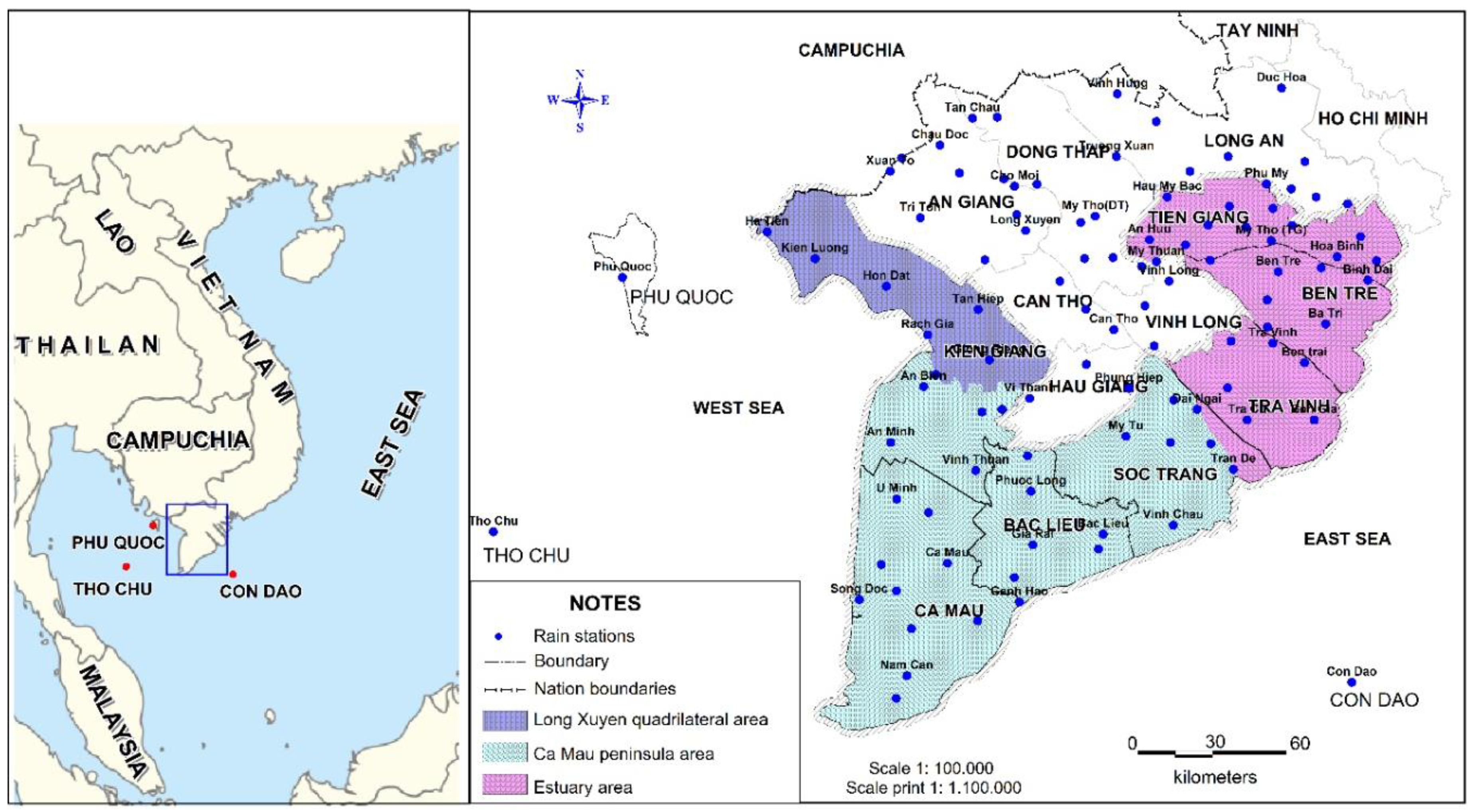
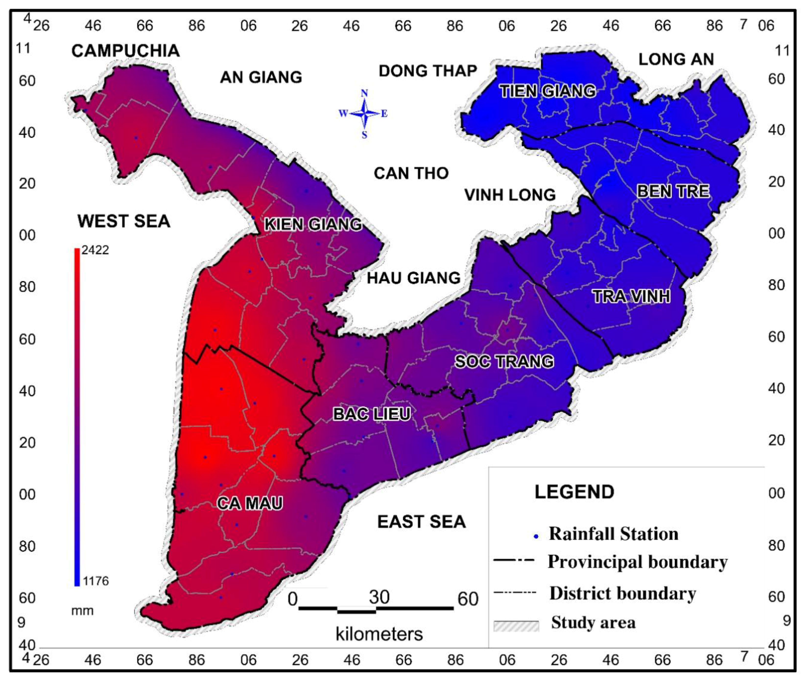
2.1. Study Area
2.2. Research Objectives
3. Database and Methods
3.1. Database
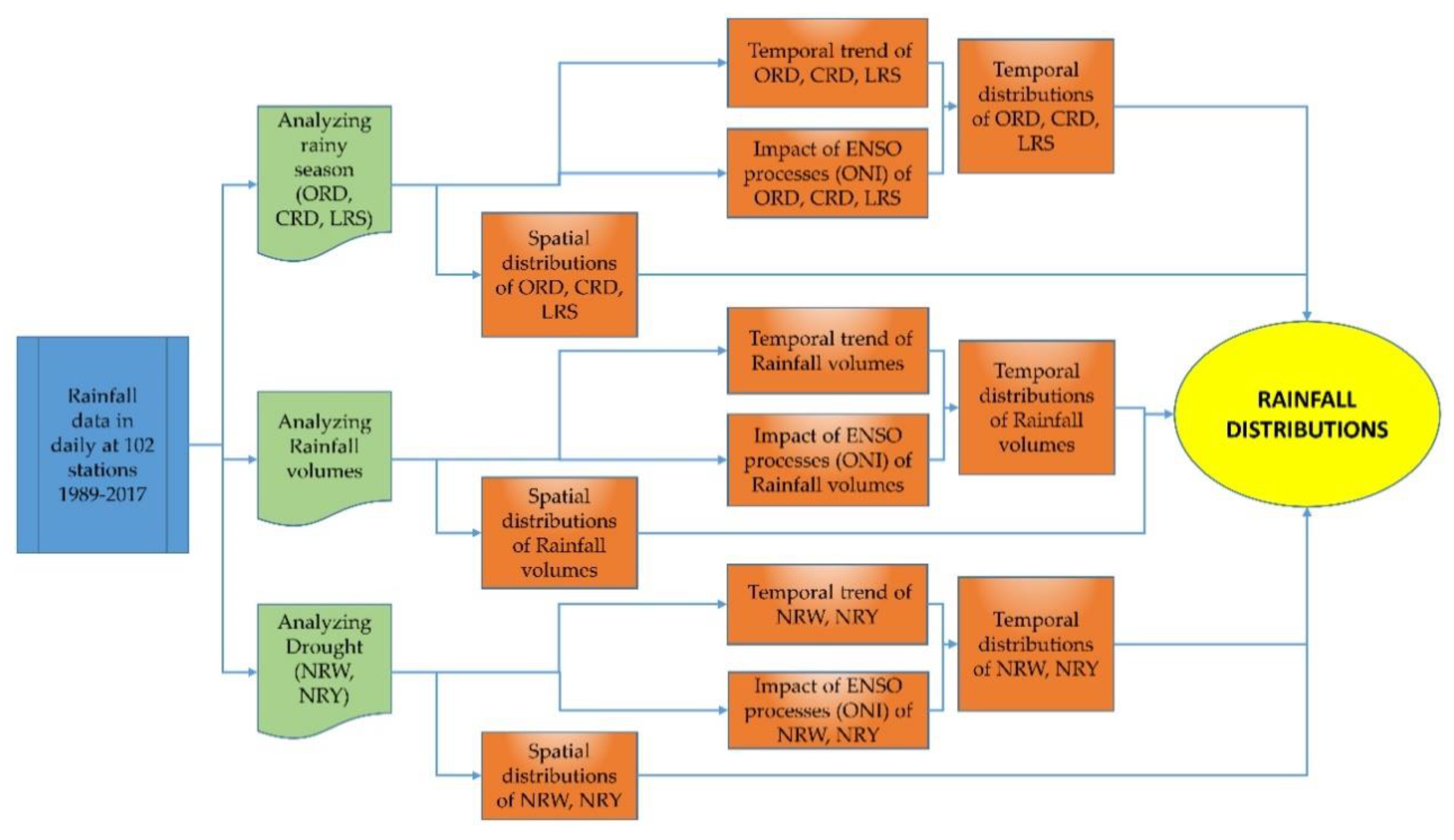
3.2. Methods
- -
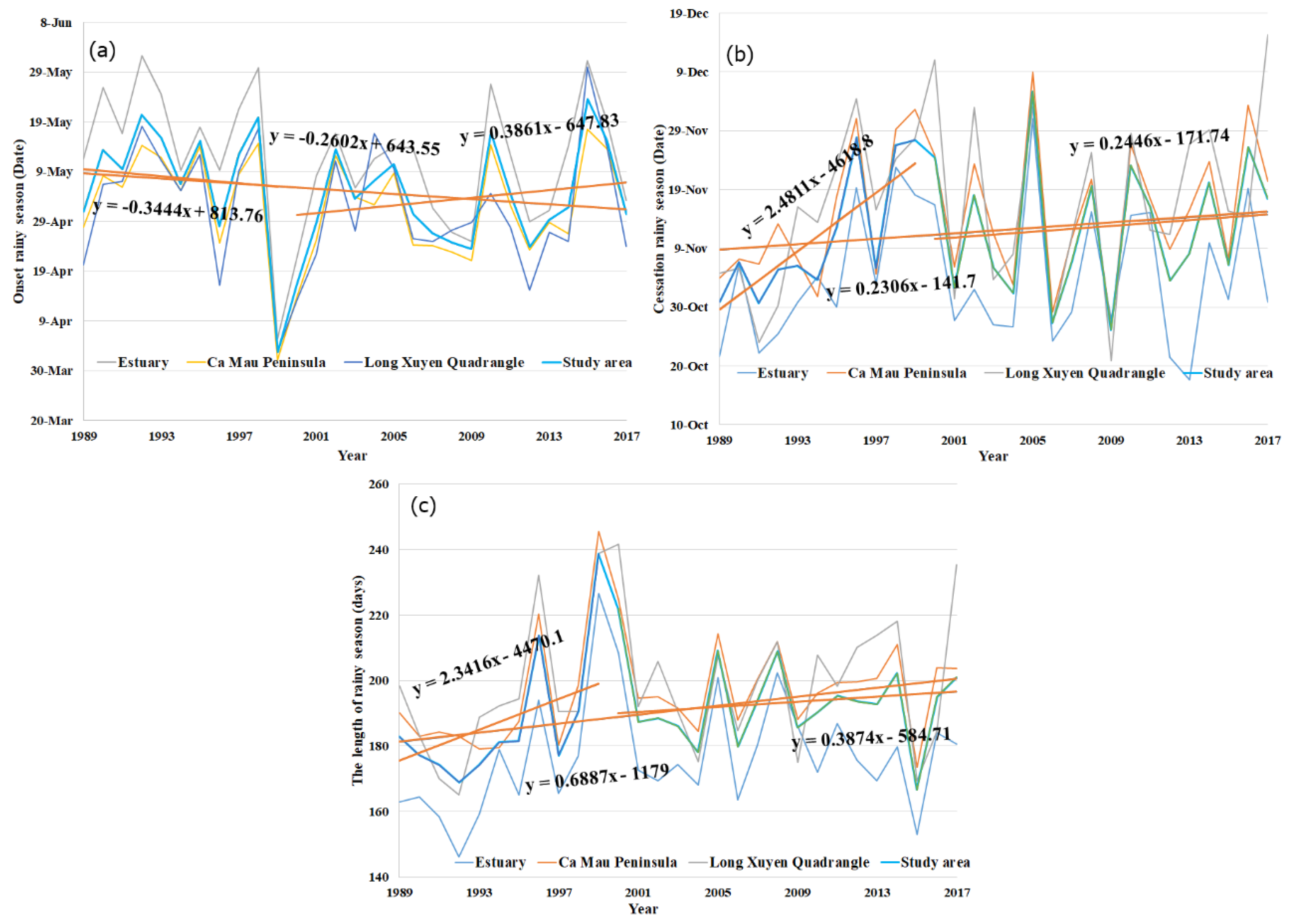
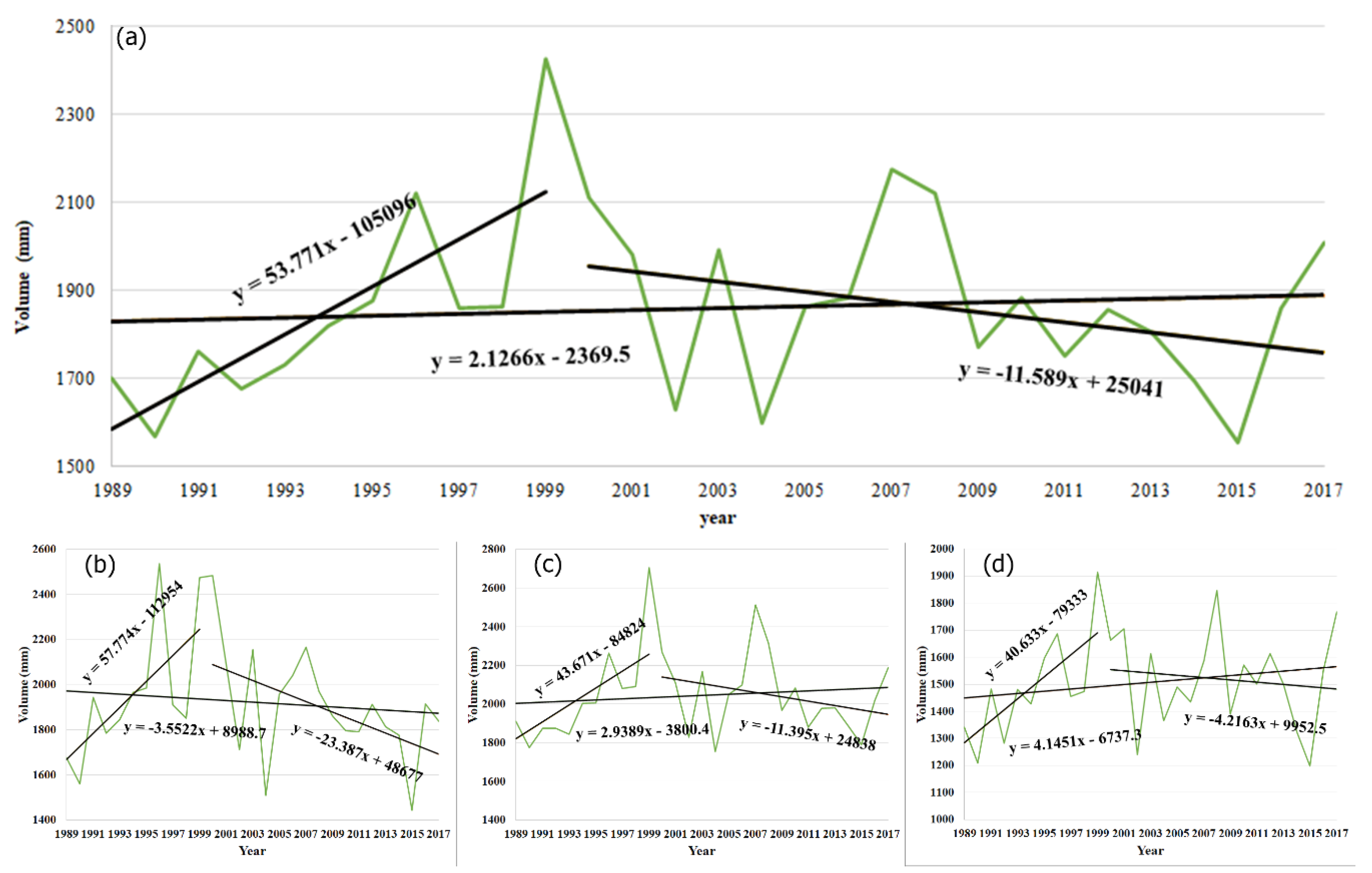
- For time-series data available from 1989–2017, observing the peak value of rainfall and the beginning of the rainy season in the study area appeared in 1999. Hence, the study used the year of 1999 as a change point to consider changes in characteristics over time.
- -
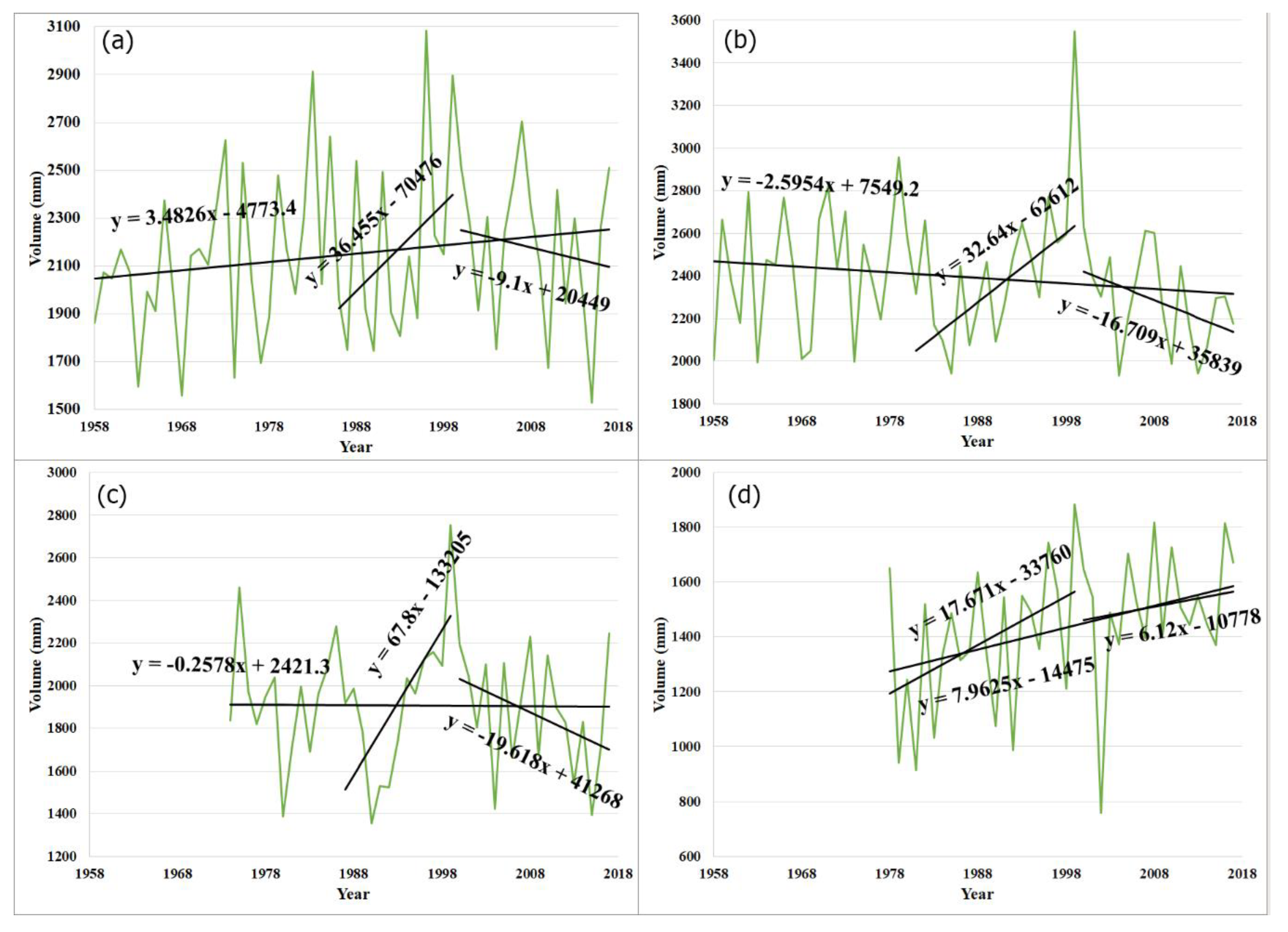
- For longer time-series data of four gauging stations of Rach Gia, Ca Mau, Soc Trang, and My Tho: the years of 2000–2017 is still considered as a period. For the period from 1999 to earlier, the year of 1999 was taken as the end year, and we tried each year until the M-K test was used to confirm the trends. Results for trend confirmation were found as Rach Gia from 1986 (significance level P = 9.44%), Ca Mau from 1981 (P = 0.4%), Soc Trang from 1987 (P = 0.9%), and My Tho from 1978 (P = 1.4%).
4. Results and Discussion
4.1. Rainfall Characteristics in the Coastal Provinces of the VMD
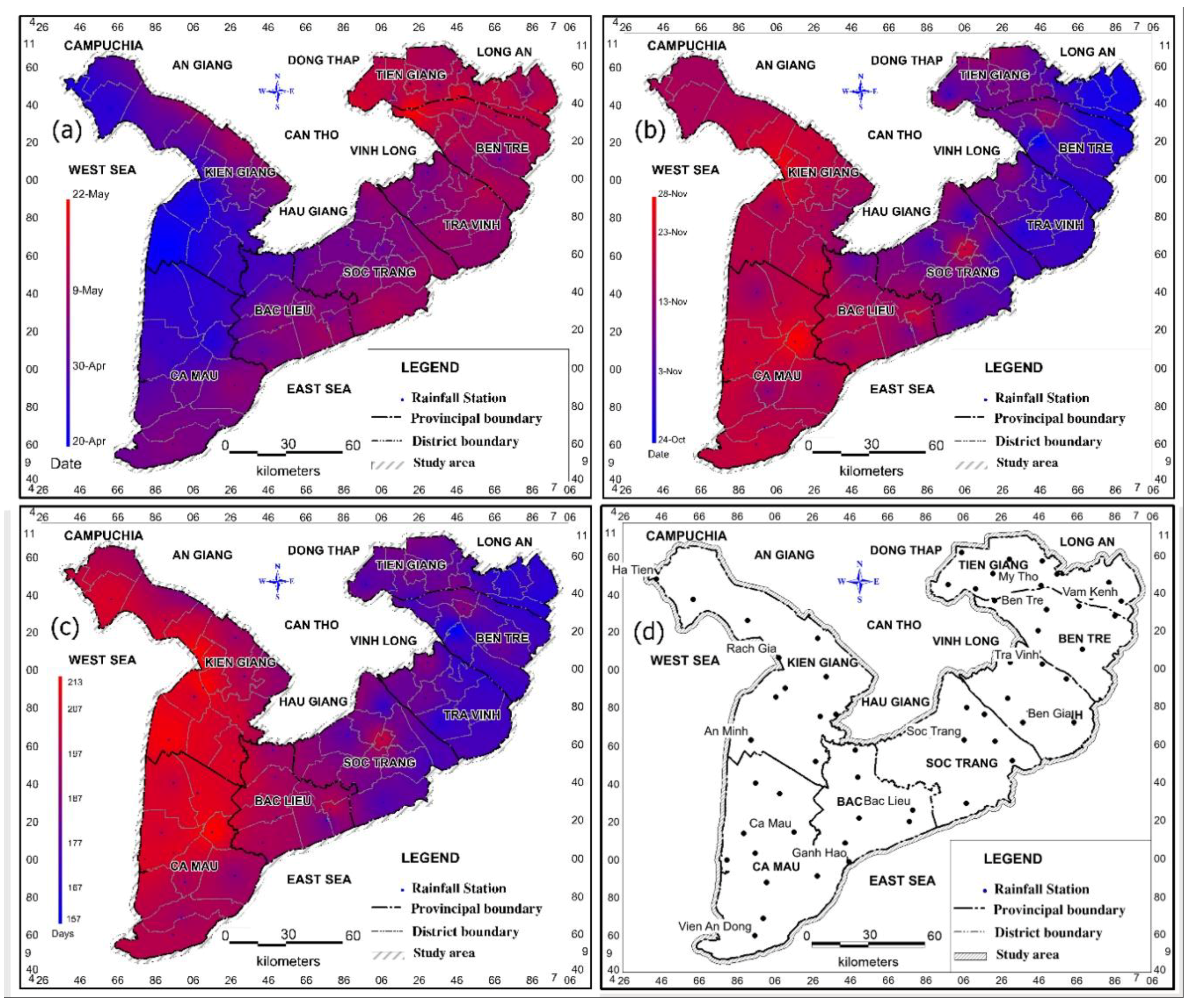
4.1.1. Spatial Distribution
4.1.2. Temporal Distribution
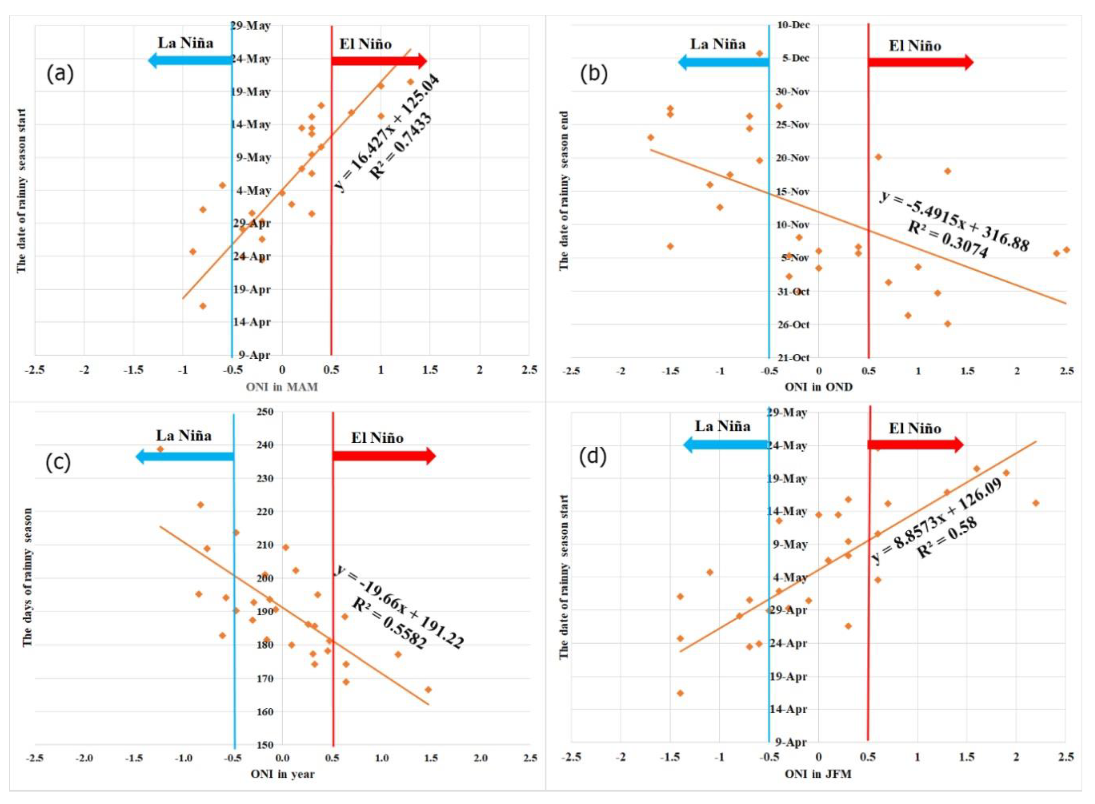
4.1.3. Impacts of the ENSO Processes
4.2. Rainfall
4.2.1. Distribution Characteristics of Rainfall
4.2.2. Rainfall Trends
4.2.3. Impacts of ENSO Processes on Rainfall
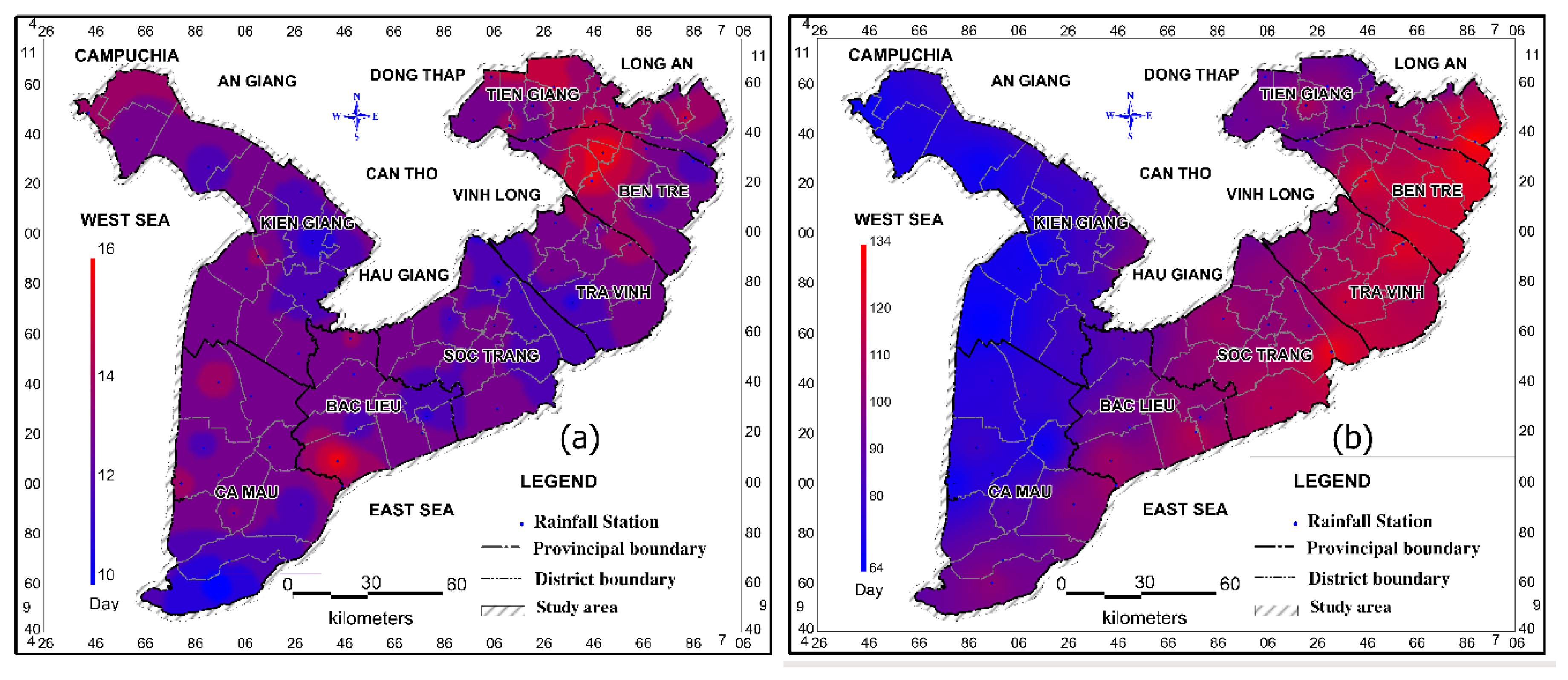
4.3. Number of Consecutive Nonrainy Days in Coastal Provinces
4.3.1. Characteristics of Rainfall Distribution
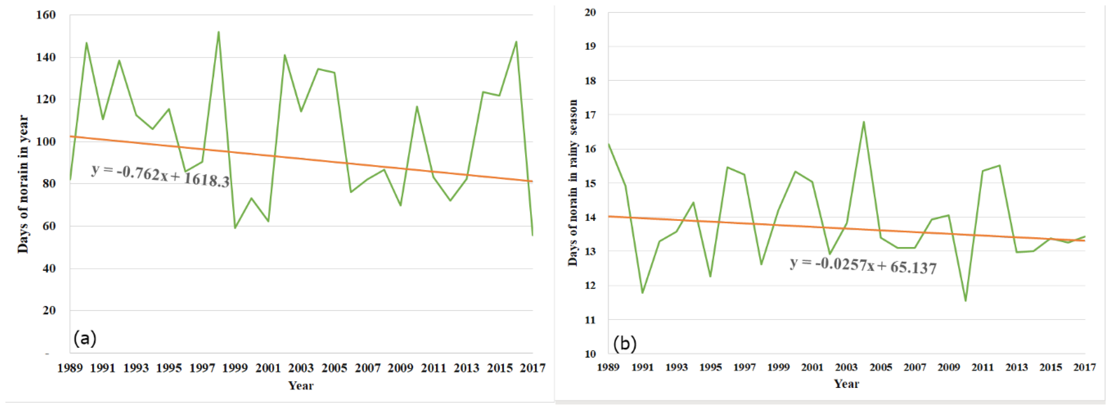
4.3.2. Trends in the Drought
4.3.3. Impacts of ENSO Processes on Drought
5. Conclusions
Author Contributions
Funding
Acknowledgments
Conflicts of Interest
Data Availability
Abbreviations
| VMD | Vietnamese Mekong Delta |
| ENSO | El Niño–Southern Oscillation |
| CMP | Ca Mau Peninsula |
| LXQ | Long Xuyen Quadrangle |
| ITCZ | Inter Tropical Convergence Zone |
| ORD | The date of onset of the rainy season |
| CRD | The cessation date of the rainy season |
| LRS | The length of the rainy season |
| VRY | Total volume of rain that falls in a year |
| VRD | The volume of rainfall in the dry season |
| NRY | Number of consecutive days without rain in a year |
| NRW | Number of consecutive days without rain in the rainy season |
| M-K | Mann–Kendall |
| ONI | Oceanic Niño Index |
| CFC | Climate Prediction Center |
| CV | Coefficient of variation |
| Cs | Coefficient of skewness |
Appendix A

| No. | Location | ORD | CRD | LRS | ||||||
|---|---|---|---|---|---|---|---|---|---|---|
| 25% | 50% | 75% | 25% | 50% | 75% | 25% | 50% | 75% | ||
| 1 | Tien Giang | 29 April | 13 May | 28 May | 17 November | 4 November | 23 October | 198 | 176 | 156 |
| 2 | Ben Tre | 29 April | 11 May | 23 May | 14 November | 1 November | 21 October | 194 | 174 | 158 |
| 3 | Tra Vinh | 27 April | 7 May | 18 May | 14 November | 2 November | 22 October | 195 | 175 | 161 |
| 4 | Soc Trang | 26 April | 6 May | 17 May | 20 November | 7 November | 26 October | 200 | 183 | 168 |
| 5 | Bạc Lieu | 22 April | 3 May | 15 May | 28 November | 15 November | 2 November | 212 | 194 | 178 |
| 6 | Ca Mau | 19 April | 30 April | 11 May | 30 November | 18 November | 6 November | 219 | 201 | 185 |
| 7 | Kien Giang | 16 April | 28 April | 11 May | 29 November | 17 November | 5 November | 222 | 201 | 183 |
| 8 | The estuaries | 28 April | 10 May | 23 May | 15 November | 2 November | 22 October | 196 | 175 | 158 |
| 9 | Ca Mau Peninsula | 20 April | 1 May | 12 May | 27 November | 15 November | 3 November | 214 | 196 | 180 |
| 10 | Long Xuyen Quadrangle | 17 April | 30 April | 14 May | 30 November | 17 November | 5 November | 219 | 199 | 179 |
| 11 | Whole area | 22 April | 4 May | 16 May | 24 November | 11 November | 30 October | 209 | 190 | 173 |
| Period | Values | Province | Subregion | Whole Area | ||||||||
|---|---|---|---|---|---|---|---|---|---|---|---|---|
| Tien Giang | Ben Tre | Tra Vinh | Soc Trang | Bac Lieu | Ca Mau | Kien Giang | The Estuaries | CMP | LXQ | |||
| Trend test of ORD | ||||||||||||
| Period of 1989–2017 | No. of year | 29 | 29 | 29 | 29 | 29 | 29 | 29 | 29 | 29 | 29 | 29 |
| Max | 164 | 155 | 147 | 145 | 142 | 141 | 142 | 153 | 139 | 151 | 145 | |
| Min | 95 | 96 | 99 | 99 | 93 | 90 | 91 | 96 | 92 | 94 | 94 | |
| TB | 135 | 133 | 130 | 129 | 126 | 122 | 120 | 133 | 123 | 123 | 126 | |
| SD | 15 | 14 | 11 | 11 | 11 | 11 | 11 | 13 | 10 | 12 | 11 | |
| Zs | −0.68 | −0.53 | −1.35 | −0.86 | −0.64 | −0.45 | −0.23 | −0.94 | −0.68 | −0.19 | −0.75 | |
| P value | 0.25 | 0.30 | 0.09 | 0.19 | 0.26 | 0.33 | 0.41 | 0.17 | 0.25 | 0.43 | 0.23 | |
| Sen’s slope | −0.48 | −0.31 | −0.41 | −0.37 | −0.10 | −0.08 | −0.05 | −0.40 | −0.18 | −0.18 | −0.26 | |
| Period of 1989–1999 | No. of year | 11 | 11 | 11 | 11 | 11 | 11 | 11 | 11 | 11 | 11 | 11 |
| Max | 164 | 155 | 144 | 144 | 142 | 141 | 133 | 153 | 136 | 139 | 141 | |
| Min | 95 | 96 | 99 | 99 | 93 | 90 | 91 | 96 | 92 | 94 | 94 | |
| TB | 141 | 137 | 134 | 133 | 127 | 123 | 121 | 137 | 125 | 124 | 129 | |
| SD | 18 | 16 | 12 | 12 | 13 | 13 | 13 | 15 | 12 | 14 | 13 | |
| Zs | −0.31 | −0.16 | −1.25 | 0.47 | −0.31 | 0.00 | −0.31 | −0.47 | 0.00 | 0.00 | −0.31 | |
| P value | 0.38 | 0.44 | 0.11 | 0.32 | 0.38 | 0.50 | 0.38 | 0.32 | 0.50 | 0.50 | 0.38 | |
| Sen’s slop | −0.30 | −0.35 | −1.11 | 0.38 | −0.38 | 0.17 | −0.29 | −0.44 | 0.04 | 0.34 | −0.34 | |
| Period of 2000–2017 | No. of year | 18 | 18 | 18 | 18 | 18 | 18 | 18 | 18 | 18 | 18 | 18 |
| Max | 156 | 155 | 147 | 145 | 141 | 138 | 142 | 152 | 139 | 151 | 145 | |
| Min | 112 | 113 | 114 | 111 | 105 | 102 | 104 | 113 | 105 | 104 | 107 | |
| TB | 132 | 130 | 128 | 126 | 125 | 121 | 119 | 130 | 122 | 122 | 124 | |
| SD | 12 | 11 | 9 | 9 | 10 | 10 | 10 | 10 | 9 | 11 | 9 | |
| Zs | 0.11 | 0.34 | 0.11 | 0.00 | 0.04 | 0.00 | 0.11 | 0.11 | −0.04 | 0.11 | 0.04 | |
| P value | 0.45 | 0.37 | 0.45 | 0.50 | 0.48 | 0.50 | 0.45 | 0.45 | 0.48 | 0.45 | 0.48 | |
| Sen’s slope | 0.55 | 0.60 | 0.60 | 0.25 | 0.63 | 0.29 | 0.24 | 0.53 | 0.43 | 0.16 | 0.39 | |
| Trend test of CRD | ||||||||||||
| Period of 1989–2017 | No. of year | 29 | 29 | 29 | 29 | 29 | 29 | 29 | 29 | 29 | 29 | 29 |
| Max | 343 | 334 | 330 | 336 | 345 | 351 | 342 | 336 | 344 | 350 | 341 | |
| Min | 293 | 290 | 292 | 290 | 292 | 300 | 296 | 292 | 300 | 295 | 300 | |
| TB | 310 | 308 | 309 | 313 | 320 | 323 | 322 | 309 | 320 | 322 | 317 | |
| SD | 14 | 12 | 10 | 11 | 13 | 13 | 13 | 11 | 11 | 14 | 11 | |
| Zs | 0.34 | 0.00 | 0.60 | 0.26 | 0.41 | 0.49 | 0.64 | 0.19 | 0.26 | 0.56 | 0.38 | |
| P value | 0.37 | 0.50 | 0.27 | 0.40 | 0.34 | 0.31 | 0.26 | 0.43 | 0.40 | 0.29 | 0.35 | |
| Sen’s slope | 0.21 | 0.00 | 0.19 | 0.09 | 0.21 | 0.59 | 0.40 | 0.12 | 0.31 | 0.60 | 0.23 | |
| Period of 1989–1999 | No. of year | 11 | 11 | 11 | 11 | 11 | 11 | 11 | 11 | 11 | 11 | 11 |
| Max | 339 | 334 | 327 | 332 | 343 | 345 | 337 | 328 | 338 | 339 | 333 | |
| Min | 293 | 292 | 296 | 307 | 305 | 300 | 303 | 296 | 306 | 298 | 305 | |
| TB | 310 | 310 | 309 | 314 | 320 | 321 | 320 | 309 | 319 | 319 | 316 | |
| SD | 14 | 12 | 9 | 8 | 13 | 14 | 11 | 11 | 11 | 12 | 10 | |
| Zs | 2.49 | 2.34 | 1.87 | 2.49 | 1.56 | 1.87 | 2.65 | 2.34 | 1.87 | 2.65 | 2.18 | |
| P value | 0.01 | 0.01 | 0.03 | 0.01 | 0.06 | 0.03 | 0.00 | 0.01 | 0.03 | 0.00 | 0.01 | |
| Sen’s slope | 3.31 | 3.04 | 1.82 | 1.02 | 3.25 | 3.20 | 3.05 | 2.73 | 2.81 | 3.04 | 2.48 | |
| Period of 2000–2017 | No. of year | 18 | 18 | 18 | 18 | 18 | 18 | 18 | 18 | 18 | 18 | 18 |
| Max | 343 | 333 | 330 | 336 | 345 | 351 | 342 | 336 | 344 | 350 | 341 | |
| Min | 293 | 290 | 292 | 290 | 292 | 302 | 296 | 292 | 300 | 295 | 300 | |
| TB | 311 | 308 | 309 | 313 | 320 | 325 | 323 | 309 | 321 | 323 | 318 | |
| SD | 14 | 12 | 10 | 13 | 13 | 12 | 13 | 12 | 11 | 15 | 11 | |
| Zs | −0.19 | −0.42 | 0.27 | −0.19 | −0.11 | −0.04 | −0.27 | −0.27 | −0.27 | −0.11 | −0.19 | |
| P value | 0.42 | 0.34 | 0.40 | 0.42 | 0.45 | 0.48 | 0.40 | 0.40 | 0.40 | 0.45 | 0.42 | |
| Sen’s slope | 0.04 | −0.30 | 0.34 | −0.24 | 0.11 | 0.82 | 0.38 | −0.12 | 0.39 | 0.64 | 0.24 | |
| Trend test of LRS | ||||||||||||
| Period of 1989–2017 | No. of year | 29 | 29 | 29 | 29 | 29 | 29 | 29 | 29 | 29 | 29 | 29 |
| Max | 232 | 224 | 223 | 231 | 245 | 255 | 241 | 227 | 245 | 242 | 239 | |
| Min | 133 | 139 | 156 | 155 | 171 | 174 | 176 | 146 | 174 | 165 | 167 | |
| TB | 175 | 176 | 179 | 185 | 194 | 202 | 202 | 177 | 197 | 199 | 191 | |
| SD | 20 | 19 | 15 | 16 | 16 | 17 | 18 | 17 | 16 | 20 | 16 | |
| Zs | 0.94 | 0.64 | 1.43 | 0.71 | 0.64 | 0.60 | 0.94 | 1.09 | 0.90 | 0.56 | 0.94 | |
| P value | 0.17 | 0.26 | 0.08 | 0.24 | 0.26 | 0.27 | 0.17 | 0.14 | 0.18 | 0.29 | 0.17 | |
| Sen’s slope | 0.71 | 0.34 | 0.60 | 0.55 | 0.28 | 0.73 | 0.80 | 0.58 | 0.66 | 0.79 | 0.69 | |
| Period of 1989–1999 | No. of year | 11 | 11 | 11 | 11 | 11 | 11 | 11 | 11 | 11 | 11 | 11 |
| Max | 232 | 224 | 223 | 231 | 245 | 255 | 241 | 227 | 245 | 239 | 239 | |
| Min | 133 | 139 | 156 | 167 | 171 | 174 | 176 | 146 | 179 | 165 | 169 | |
| TB | 169 | 173 | 175 | 181 | 193 | 197 | 198 | 173 | 194 | 195 | 187 | |
| SD | 25 | 22 | 19 | 18 | 21 | 23 | 20 | 21 | 20 | 21 | 20 | |
| Zs | 2.02 | 1.25 | 2.18 | 0.62 | 1.40 | 0.78 | 2.34 | 2.34 | 0.93 | 1.40 | 1.56 | |
| P value | 0.02 | 0.11 | 0.01 | 0.27 | 0.08 | 0.22 | 0.01 | 0.01 | 0.18 | 0.08 | 0.06 | |
| Sen’s slope | 3.59 | 3.45 | 2.60 | 0.62 | 3.41 | 1.75 | 4.01 | 3.54 | 1.33 | 2.89 | 2.34 | |
| Period of 2000–2017 | No. of year | 18 | 18 | 18 | 18 | 18 | 18 | 18 | 18 | 18 | 18 | 18 |
| Max | 209 | 213 | 206 | 222 | 218 | 227 | 238 | 208 | 225 | 242 | 222 | |
| Min | 155 | 144 | 160 | 155 | 171 | 181 | 176 | 153 | 174 | 169 | 167 | |
| TB | 179 | 177 | 181 | 187 | 195 | 204 | 204 | 179 | 199 | 201 | 193 | |
| SD | 15 | 16 | 11 | 15 | 12 | 12 | 16 | 14 | 12 | 19 | 12 | |
| Zs | −0.11 | −0.27 | 0.00 | −0.11 | −0.34 | −0.27 | −0.04 | −0.19 | −0.19 | −0.27 | −0.19 | |
| P value | 0.45 | 0.40 | 0.50 | 0.45 | 0.37 | 0.40 | 0.48 | 0.42 | 0.42 | 0.40 | 0.42 | |
| Sen’s slope | −0.13 | −0.32 | −0.30 | −0.25 | −0.72 | 0.23 | 0.80 | −0.26 | 0.45 | 0.74 | 0.39 | |
| Trend test of annual rainfall | ||||||||||||
| Period of 1989–2017 | No. of year | 29 | 29 | 29 | 29 | 29 | 29 | 29 | 29 | 29 | 29 | 29 |
| Max | 1835 | 1858 | 2108 | 2339 | 2566 | 2906 | 2653 | 1915 | 2706 | 2538 | 2427 | |
| Min | 1118 | 1159 | 1251 | 1290 | 1543 | 1908 | 1567 | 1197 | 1755 | 1443 | 1556 | |
| TB | 1439 | 1485 | 1584 | 1716 | 1921 | 2247 | 2028 | 1507 | 2045 | 1923 | 1860 | |
| SD | 192 | 182 | 199 | 214 | 245 | 232 | 234 | 177 | 214 | 257 | 196 | |
| Zs | 0.68 | 0.41 | 0.56 | 1.01 | 1.46 | 0.94 | 0.94 | 0.68 | 1.13 | 0.90 | 1.13 | |
| P value | 0.25 | 0.34 | 0.29 | 0.16 | 0.07 | 0.17 | 0.17 | 0.25 | 0.13 | 0.18 | 0.13 | |
| Sen’s slope | 12.48 | 2.38 | −1.77 | −0.33 | 10.19 | 2.66 | −1.25 | 4.15 | 2.94 | −3.55 | 2.13 | |
| Period of 1989–1999 | No. of year | 11 | 11 | 11 | 11 | 11 | 11 | 11 | 11 | 11 | 11 | 11 |
| Max | 1741 | 1856 | 2108 | 2339 | 2566 | 2906 | 2653 | 1915 | 2706 | 2538 | 2427 | |
| Min | 1118 | 1164 | 1261 | 1466 | 1543 | 1947 | 1756 | 1209 | 1774 | 1560 | 1568 | |
| TB | 1364 | 1470 | 1605 | 1738 | 1861 | 2236 | 2062 | 1487 | 2039 | 1958 | 1855 | |
| SD | 181 | 195 | 201 | 227 | 289 | 252 | 269 | 186 | 249 | 286 | 226 | |
| Zs | 2.34 | 1.87 | 1.71 | 2.18 | 2.96 | 3.11 | 2.49 | 2.02 | 2.96 | 2.18 | 2.96 | |
| P value | 0.01 | 0.03 | 0.04 | 0.01 | 0.00 | 0.00 | 0.01 | 0.02 | 0.00 | 0.01 | 0.00 | |
| Sen’s slope | 51.49 | 48.70 | 31.87 | 44.90 | 59.81 | 44.91 | 42.55 | 40.63 | 43.67 | 57.77 | 53.77 | |
| Period of 2000–2017 | No. of year | 18 | 18 | 18 | 18 | 18 | 18 | 18 | 18 | 18 | 18 | 18 |
| Max | 1835 | 1858 | 1931 | 2084 | 2369 | 2810 | 2447 | 1846 | 2512 | 2483 | 2175 | |
| Min | 1156 | 1159 | 1251 | 1290 | 1596 | 1908 | 1567 | 1197 | 1755 | 1443 | 1556 | |
| TB | 1484 | 1494 | 1571 | 1702 | 1957 | 2254 | 2008 | 1520 | 2049 | 1902 | 1863 | |
| SD | 185 | 174 | 196 | 204 | 206 | 219 | 207 | 170 | 190 | 235 | 175 | |
| Zs | −0.11 | −0.19 | −0.04 | 0.04 | 0.27 | −0.11 | 0.00 | −0.19 | 0.00 | −0.04 | 0.00 | |
| P value | 0.45 | 0.42 | 0.48 | 0.48 | 0.40 | 0.45 | 0.50 | 0.42 | 0.50 | 0.48 | 0.50 | |
| Sen’s slope | 12.45 | −3.77 | −10.02 | −16.39 | −1.75 | −6.24 | −15.86 | −4.22 | −11.39 | −23.39 | −11.59 | |
| Trend test of rainfall in the dry season | ||||||||||||
| Period of 1989–2017 | No. of year | 29 | 29 | 29 | 29 | 29 | 29 | 29 | 29 | 29 | 29 | 29 |
| Max | 285 | 264 | 265 | 371 | 456 | 501 | 512 | 273 | 482 | 440 | 411 | |
| Min | 6 | 3 | 1 | 4 | 2 | 8 | 11 | 6 | 7 | 8 | 7 | |
| TB | 66 | 57 | 62 | 81 | 105 | 136 | 156 | 62 | 123 | 144 | 107 | |
| SD | 60 | 57 | 59 | 81 | 97 | 109 | 110 | 58 | 100 | 103 | 86 | |
| Zs | 0.34 | 0.11 | 0.53 | 0.04 | −0.41 | −0.04 | 0.00 | 0.15 | 0.00 | 0.00 | −0.04 | |
| P value | 0.37 | 0.46 | 0.30 | 0.49 | 0.34 | 0.49 | 0.50 | 0.44 | 0.50 | 0.50 | 0.49 | |
| Sen’s slope | 1.69 | 0.88 | 0.60 | 0.91 | −0.37 | −0.14 | 0.30 | 1.16 | 0.36 | 1.56 | 0.99 | |
| Period of 1989–1999 | No. of year | 11 | 11 | 11 | 11 | 11 | 11 | 11 | 11 | 11 | 11 | 11 |
| Max | 285 | 264 | 265 | 371 | 456 | 501 | 512 | 273 | 482 | 440 | 411 | |
| Min | 6 | 5 | 11 | 14 | 7 | 24 | 56 | 14 | 29 | 33 | 28 | |
| TB | 60 | 52 | 50 | 71 | 111 | 136 | 156 | 54 | 124 | 137 | 104 | |
| SD | 76 | 70 | 69 | 96 | 115 | 125 | 126 | 71 | 119 | 110 | 102 | |
| Zs | 1.09 | 0.62 | 0.93 | 0.16 | −0.78 | 0.16 | 0.93 | 0.62 | 0.16 | 0.78 | 0.31 | |
| P value | 0.14 | 0.27 | 0.18 | 0.44 | 0.22 | 0.44 | 0.18 | 0.27 | 0.44 | 0.22 | 0.38 | |
| Sen’s slope | 5.66 | 2.42 | 1.09 | 0.05 | −7.63 | 2.96 | 12.22 | 2.84 | 2.60 | 10.98 | 2.08 | |
| Period of 2000–2017 | No. of year | 18 | 18 | 18 | 18 | 18 | 18 | 18 | 18 | 18 | 18 | 18 |
| Max | 153 | 165 | 166 | 253 | 276 | 301 | 330 | 165 | 271 | 342 | 242 | |
| Min | 7 | 3 | 1 | 4 | 2 | 8 | 11 | 6 | 7 | 8 | 7 | |
| TB | 71 | 60 | 70 | 87 | 102 | 137 | 155 | 67 | 123 | 149 | 109 | |
| SD | 47 | 47 | 52 | 71 | 85 | 98 | 99 | 47 | 87 | 98 | 74 | |
| Zs | −0.11 | −0.04 | −0.27 | −0.04 | −0.19 | −0.11 | −0.27 | −0.04 | −0.04 | −0.19 | −0.11 | |
| P value | 0.45 | 0.48 | 0.40 | 0.48 | 0.42 | 0.45 | 0.40 | 0.48 | 0.48 | 0.42 | 0.45 | |
| Sen’s slope | 1.60 | −0.42 | −0.99 | −0.34 | −0.28 | −1.97 | −2.79 | 0.07 | −1.11 | −1.20 | −1.02 | |
| Period of 1989–2017 | No. of year | 29 | 29 | 29 | 29 | 29 | 29 | 29 | 29 | 29 | 29 | 29 |
| Max | 172 | 181 | 167 | 168 | 174 | 142 | 141 | 173 | 152 | 144 | 152 | |
| Min | 55 | 65 | 52 | 65 | 58 | 41 | 41 | 63 | 53 | 41 | 56 | |
| TB | 112 | 121 | 120 | 114 | 104 | 91 | 85 | 117 | 98 | 86 | 103 | |
| SD | 35 | 32 | 28 | 28 | 31 | 32 | 28 | 31 | 30 | 29 | 29 | |
| Zs | −0.49 | −0.38 | −0.56 | −0.56 | −0.26 | −0.38 | −0.23 | −0.45 | −0.45 | 0.00 | −0.38 | |
| P value | 0.31 | 0.35 | 0.29 | 0.29 | 0.40 | 0.35 | 0.41 | 0.33 | 0.33 | 0.50 | 0.35 | |
| Sen’s slope | −1.01 | −0.96 | −0.94 | −0.54 | −0.43 | −0.83 | −0.26 | −1.00 | −0.70 | −0.39 | −0.76 | |
| Period of 1989–1999 | No. of year | 11 | 11 | 11 | 11 | 11 | 11 | 11 | 11 | 11 | 11 | 11 |
| Max | 172 | 181 | 167 | 168 | 174 | 142 | 127 | 173 | 152 | 126 | 152 | |
| Min | 55 | 79 | 92 | 72 | 68 | 41 | 43 | 76 | 53 | 45 | 59 | |
| TB | 123 | 129 | 128 | 122 | 111 | 96 | 88 | 127 | 104 | 90 | 109 | |
| SD | 36 | 35 | 27 | 27 | 29 | 29 | 24 | 32 | 27 | 25 | 27 | |
| Zs | −1.09 | −0.78 | −1.09 | −0.31 | 0.00 | −0.78 | −0.62 | −1.09 | −0.93 | −0.16 | −0.62 | |
| P value | 0.14 | 0.22 | 0.14 | 0.38 | 0.50 | 0.22 | 0.27 | 0.14 | 0.18 | 0.44 | 0.27 | |
| Sen’s slope | −5.93 | −4.44 | −4.61 | −3.24 | 0.17 | −3.64 | −3.74 | −5.47 | −4.83 | −1.94 | −4.91 | |
| Period of 2000–2017 | No. of year | 18 | 18 | 18 | 18 | 18 | 18 | 18 | 18 | 18 | 18 | 18 |
| Max | 165 | 162 | 152 | 159 | 151 | 140 | 141 | 157 | 146 | 144 | 147 | |
| Min | 70 | 65 | 52 | 65 | 58 | 46 | 41 | 63 | 54 | 41 | 56 | |
| TB | 104 | 116 | 114 | 109 | 100 | 89 | 83 | 112 | 95 | 84 | 99 | |
| SD | 32 | 29 | 28 | 28 | 32 | 33 | 30 | 28 | 31 | 31 | 29 | |
| Zs | 0.04 | 0.04 | 0.11 | −0.04 | −0.04 | 0.00 | 0.19 | 0.11 | 0.00 | 0.19 | 0.04 | |
| P value | 0.48 | 0.48 | 0.45 | 0.48 | 0.48 | 0.50 | 0.42 | 0.45 | 0.50 | 0.42 | 0.48 | |
| Sen’s slope | 0.75 | −0.50 | −0.26 | 0.73 | −0.20 | −0.52 | 1.07 | −0.07 | 0.11 | 0.25 | 0.29 | |
| Test the trend of the longest consecutive days without rain in the rainy season | ||||||||||||
| Period of 1989–2017 | No. of year | 29 | 29 | 29 | 29 | 29 | 29 | 29 | 29 | 29 | 29 | 29 |
| Max | 19 | 20 | 21 | 21 | 24 | 22 | 23 | 18 | 21 | 19 | 19 | |
| Min | 12 | 11 | 10 | 10 | 9 | 11 | 11 | 11 | 11 | 11 | 12 | |
| TB | 15 | 15 | 14 | 14 | 14 | 14 | 14 | 15 | 14 | 14 | 14 | |
| SD | 2 | 2 | 2 | 3 | 3 | 2 | 2 | 2 | 2 | 2 | 2 | |
| Zs | −0.41 | −0.08 | 0.30 | 0.00 | 0.04 | −0.64 | 0.41 | −0.19 | −0.41 | 0.56 | −0.23 | |
| P value | 0.34 | 0.47 | 0.38 | 0.50 | 0.49 | 0.26 | 0.34 | 0.43 | 0.34 | 0.29 | 0.41 | |
| Sen’s slope | −0.09 | 0.01 | 0.02 | −0.01 | −0.04 | −0.06 | 0.03 | −0.03 | −0.05 | 0.06 | −0.03 | |
| Period of 1989–1999 | No. of year | 11 | 11 | 11 | 11 | 11 | 11 | 11 | 11 | 11 | 11 | 11 |
| Max | 19 | 20 | 18 | 17 | 24 | 22 | 23 | 18 | 21 | 19 | 19 | |
| Min | 12 | 11 | 10 | 10 | 10 | 11 | 11 | 11 | 12 | 11 | 12 | |
| TB | 16 | 15 | 14 | 14 | 14 | 14 | 14 | 15 | 14 | 14 | 14 | |
| SD | 2 | 3 | 3 | 3 | 3 | 3 | 3 | 2 | 2 | 2 | 2 | |
| Zs | 0.47 | 0.00 | 0.00 | −0.16 | 0.00 | −0.62 | 1.09 | −0.31 | −0.31 | 0.31 | −0.16 | |
| P value | 0.32 | 0.50 | 0.50 | 0.44 | 0.50 | 0.27 | 0.14 | 0.38 | 0.38 | 0.38 | 0.44 | |
| Sen’s slope | 0.07 | −0.01 | −0.01 | −0.02 | 0.01 | −0.15 | 0.20 | −0.09 | −0.07 | 0.08 | −0.08 | |
| Period of 2000–2017 | No. of year | 18 | 18 | 18 | 18 | 18 | 18 | 18 | 18 | 18 | 18 | 18 |
| Max | 16 | 18 | 21 | 21 | 24 | 17 | 15 | 17 | 17 | 16 | 17 | |
| Min | 12 | 13 | 11 | 11 | 9 | 11 | 12 | 12 | 11 | 11 | 12 | |
| TB | 15 | 15 | 14 | 14 | 14 | 13 | 13 | 15 | 14 | 14 | 14 | |
| SD | 1 | 2 | 2 | 3 | 3 | 2 | 1 | 1 | 2 | 1 | 1 | |
| Zs | −0.34 | −0.19 | 0.11 | −0.11 | −0.57 | −0.42 | 0.34 | −0.27 | −0.57 | 0.42 | −0.42 | |
| P value | 0.37 | 0.42 | 0.45 | 0.45 | 0.28 | 0.34 | 0.37 | 0.40 | 0.28 | 0.34 | 0.34 | |
| Sen’s slope | −0.08 | −0.02 | −0.07 | −0.04 | −0.23 | −0.09 | 0.07 | −0.06 | −0.12 | 0.10 | −0.04 | |
| Characteristics | Rach Gia | Ca Mau | Soc Trang | My Tho | |
|---|---|---|---|---|---|
| Period of 1958–2017 | No. of year | 59 (1958) | 59 (1958) | 44 (1974) | 40 (1978) |
| Max | 3085 | 3549 | 2754 | 1884 | |
| Min | 1529 | 1932 | 1395 | 758 | |
| TB | 2150 | 2390 | 1907 | 1434 | |
| SD | 343 | 297 | 288 | 257 | |
| Zs | 1.04 | 0.11 | −0.07 | 2.69 | |
| P value | 0.15 | 0.46 | 0.47 | 0.004 | |
| Sen’s slope | 3.48 | −2.60 | −0.26 | 7.96 | |
| Period 1958 to 1999 | No. of year | 14 (1986) | 19 (1981) | 13 (1987) | 22 (1978) |
| Max | 3085 | 3549 | 2754 | 1884 | |
| Min | 2895 | 2299 | 2754 | 1211 | |
| TB | 2178 | 2430 | 1920 | 1371 | |
| SD | 410 | 346 | 342 | 261 | |
| Zs | 1.31 | 2.66 | 2.38 | 2.20 | |
| P value | 0.09 | 0.00 | 0.01 | 0.01 | |
| Sen’s slope | 36.45 | 32.64 | 67.80 | 17.67 | |
| Period of 2000–2017 | No. of year | 18 | 18 | 18 | 18 |
| Max | 2705 | 2630 | 2247 | 1818 | |
| Min | 2510 | 2175 | 2247 | 1670 | |
| TB | 2177 | 2287 | 1875 | 1511 | |
| SD | 313 | 215 | 263 | 230 | |
| Zs | −0.38 | −1.29 | −0.76 | 0.68 | |
| P value | 0.35 | 0.10 | 0.22 | 0.25 | |
| Sen’s slope | −9.10 | −16.71 | −19.62 | 6.12 |
| No. | Station/Region | Duration | No. of Year | Lag-1 | Lag-2 | ||||||
|---|---|---|---|---|---|---|---|---|---|---|---|
| AC | PC | Q-Start | Prob | AC | PC | Q-Start | Prob | ||||
| I | Annual rainfall | ||||||||||
| 1.1 | Whole area | 1989–2017 | 29 | 0.296 | 0.296 | 2.8051 | 0.094 | 0.120 | 0.036 | 3.2849 | 0.194 |
| 1.2 | LXQ | 1989–2017 | 29 | 0.236 | 0.236 | 1.7812 | 0.182 | 0.073 | 0.019 | 1.9604 | 0.375 |
| 1.3 | CMP | 1989–2017 | 29 | 0.348 | 0.348 | 3.8915 | 0.049 | 0.156 | 0.039 | 4.6984 | 0.095 |
| 1.4 | The estuary | 1989–2017 | 29 | 0.097 | 0.097 | 0.3014 | 0.583 | 0.033 | 0.023 | 0.3367 | 0.845 |
| 1.5 | Tien Giang | 1989–2017 | 29 | 0.313 | 0.313 | 3.1362 | 0.077 | 0.056 | −0.046 | 3.2411 | 0.198 |
| 1.6 | Ben Tre | 1989–2017 | 29 | 0.415 | 0.415 | 5.5404 | 0.019 | 0.067 | −0.127 | 5.6914 | 0.058 |
| 1.7 | Tra Vinh | 1989–2017 | 29 | 0.254 | 0.254 | 2.0716 | 0.150 | 0.183 | 0.127 | 3.1872 | 0.203 |
| 1.8 | Soc Trang | 1989–2017 | 29 | 0.161 | 0.161 | 0.8329 | 0.361 | 0.311 | 0.293 | 4.0609 | 0.131 |
| 1.9 | Bạc Lieu | 1989–2017 | 29 | −0.013 | −0.013 | 0.0051 | 0.943 | 0.116 | 0.115 | 0.4498 | 0.799 |
| 1.10 | Ca Mau | 1989–2017 | 29 | 0.085 | 0.085 | 0.2301 | 0.631 | 0.103 | 0.096 | 0.5831 | 0.747 |
| 1.11 | Kien Giang | 1989–2017 | 29 | 0.286 | 0.286 | 2.6294 | 0.105 | 0.039 | −0.047 | 2.6795 | 0.262 |
| II | ORD | ||||||||||
| 2.1 | Whole area | 1989–2017 | 29 | 0.195 | 0.195 | 1.2170 | 0.270 | −0.174 | −0.220 | 2.2229 | 0.329 |
| 2.2 | LXQ | 1989–2017 | 29 | 0.120 | 0.120 | 0.4646 | 0.495 | −0.169 | −0.186 | 1.4121 | 0.494 |
| 2.3 | CMP | 1989–2017 | 29 | 0.189 | 0.189 | 1.1499 | 0.284 | −0.113 | −0.154 | 1.5744 | 0.455 |
| 2.4 | The estuary | 1989–2017 | 29 | 0.202 | 0.202 | 1.3158 | 0.251 | −0.204 | −0.255 | 2.6973 | 0.260 |
| 2.5 | Tien Giang | 1989–2017 | 29 | 0.154 | 0.154 | 0.7601 | 0.383 | −0.201 | −0.230 | 2.1100 | 0.348 |
| 2.6 | Ben Tre | 1989–2017 | 29 | 0.190 | 0.190 | 1.1614 | 0.281 | −0.197 | −0.242 | 2.4573 | 0.293 |
| 2.7 | Tra Vinh | 1989–2017 | 29 | 0.230 | 0.230 | 1.7005 | 0.192 | −0.159 | −0.224 | 2.5473 | 0.280 |
| 2.8 | Soc Trang | 1989–2017 | 29 | 0.195 | 0.195 | 1.2223 | 0.269 | −0.121 | −0.165 | 1.7077 | 0.426 |
| 2.9 | Bạc Lieu | 1989–2017 | 29 | 0.129 | 0.129 | 0.5337 | 0.465 | −0.100 | −0.119 | 0.8666 | 0.648 |
| 2.10 | Ca Mau | 1989–2017 | 29 | 0.169 | 0.169 | 0.9119 | 0.340 | −0.180 | −0.215 | 1.9921 | 0.369 |
| 2.11 | Kien Giang | 1989–2017 | 29 | 0.176 | 0.176 | 1.0001 | 0.317 | −0.141 | −0.178 | 1.6643 | 0.435 |
| III | CRD | ||||||||||
| 3.1 | Whole area | 1989–2017 | 29 | −0.179 | −0.179 | 1.0286 | 0.310 | 0.065 | 0.034 | 1.1685 | 0.558 |
| 3.2 | LXQ | 1989–2017 | 29 | −0.090 | −0.090 | 0.2616 | 0.609 | 0.146 | 0.139 | 0.9718 | 0.615 |
| 3.3 | CMP | 1989–2017 | 29 | −0.217 | −0.217 | 1.5052 | 0.220 | −0.004 | −0.053 | 1.5056 | 0.471 |
| 3.4 | The estuary | 1989–2017 | 29 | −0.074 | −0.074 | 0.1776 | 0.673 | 0.031 | 0.025 | 0.2093 | 0.901 |
| 3.5 | Tien Giang | 1989–2017 | 29 | −0.081 | −0.081 | 0.2117 | 0.645 | 0.043 | 0.036 | 0.2728 | 0.872 |
| 3.6 | Ben Tre | 1989–2017 | 29 | −0.004 | −0.004 | 0.0006 | 0.981 | 0.048 | 0.048 | 0.0770 | 0.962 |
| 3.7 | Tra Vinh | 1989–2017 | 29 | −0.097 | −0.097 | 0.3045 | 0.581 | −0.092 | −0.103 | 0.5886 | 0.745 |
| 3.8 | Soc Trang | 1989–2017 | 29 | −0.209 | −0.209 | 1.3970 | 0.237 | −0.136 | −0.188 | 2.0134 | 0.365 |
| 3.9 | Bạc Lieu | 1989–2017 | 29 | −0.147 | −0.147 | 0.6972 | 0.404 | −0.175 | −0.201 | 1.7199 | 0.423 |
| 3.10 | Ca Mau | 1989–2017 | 29 | −0.196 | −0.196 | 1.2326 | 0.267 | −0.012 | −0.053 | 1.2377 | 0.539 |
| 3.11 | Kien Giang | 1989–2017 | 29 | −0.091 | −0.091 | 0.2634 | 0.608 | 0.184 | 0.177 | 1.3885 | 0.499 |
| IV | LRS | ||||||||||
| 4.1 | Whole area | 1989–2017 | 29 | 0.201 | 0.201 | 1.2989 | 0.254 | −0.027 | −0.070 | 1.3225 | 0.516 |
| 4.2 | LXQ | 1989–2017 | 29 | 0.138 | 0.138 | 0.6110 | 0.434 | −0.114 | −0.136 | 1.0448 | 0.593 |
| 4.3 | CMP | 1989–2017 | 29 | 0.165 | 0.165 | 0.8714 | 0.351 | −0.062 | −0.092 | 0.9991 | 0.607 |
| 4.4 | The estuary | 1989–2017 | 29 | 0.236 | 0.236 | 1.7918 | 0.181 | 0.025 | −0.033 | 1.8124 | 0.404 |
| 4.5 | Tien Giang | 1989–2017 | 29 | 0.282 | 0.282 | 2.5559 | 0.110 | 0.067 | −0.014 | 2.7034 | 0.259 |
| 4.6 | Ben Tre | 1989–2017 | 29 | 0.253 | 0.253 | 2.0520 | 0.152 | −0.012 | −0.082 | 2.0571 | 0.358 |
| 4.7 | Tra Vinh | 1989–2017 | 29 | 0.099 | 0.099 | 0.3157 | 0.574 | 0.003 | −0.007 | 0.3159 | 0.854 |
| 4.8 | Soc Trang | 1989–2017 | 29 | 0.047 | 0.047 | 0.0720 | 0.788 | −0.130 | −0.132 | 0.6327 | 0.729 |
| 4.9 | Bạc Lieu | 1989–2017 | 29 | 0.149 | 0.149 | 0.7136 | 0.398 | −0.025 | −0.049 | 0.7350 | 0.692 |
| 4.10 | Ca Mau | 1989–2017 | 29 | 0.126 | 0.126 | 0.5101 | 0.475 | −0.076 | −0.093 | 0.7001 | 0.705 |
| 4.11 | Kien Giang | 1989–2017 | 29 | 0.221 | 0.221 | 1.5618 | 0.211 | −0.037 | −0.090 | 1.6085 | 0.447 |
| V | The longest consecutive days without rain in the year | ||||||||||
| 5.1 | Whole area | 1989–2017 | 29 | −0.002 | −0.002 | 0.0002 | 0.990 | 0.024 | 0.024 | 0.0188 | 0.991 |
| 5.2 | LXQ | 1989–2017 | 29 | −0.013 | −0.013 | 0.0054 | 0.942 | 0.047 | 0.047 | 0.0798 | 0.961 |
| 5.3 | CNP | 1989–2017 | 29 | −0.039 | −0.039 | 0.0480 | 0.827 | −0.014 | −0.016 | 0.0549 | 0.973 |
| 5.4 | The estuary | 1989–2017 | 29 | 0.022 | 0.022 | 0.0159 | 0.900 | 0.094 | 0.093 | 0.3088 | 0.857 |
| 5.5 | Tien Giang | 1989–2017 | 29 | 0.142 | 0.142 | 0.6511 | 0.420 | 0.144 | 0.126 | 1.3399 | 0.512 |
| 5.6 | Ben Tre | 1989–2017 | 29 | −0.039 | −0.039 | 0.0478 | 0.827 | −0.039 | −0.039 | 0.0478 | 0.827 |
| 5.7 | Tra Vinh | 1989–2017 | 29 | −0.032 | −0.032 | 0.0330 | 0.856 | 0.045 | 0.044 | 0.1002 | 0.951 |
| 5.8 | Soc Trang | 1989–2017 | 29 | −0.066 | −0.066 | 0.1416 | 0.707 | 0.112 | 0.108 | 0.5604 | 0.756 |
| 5.9 | Bạc Lieu | 1989–2017 | 29 | −0.123 | −0.123 | 0.4888 | 0.484 | −0.114 | −0.131 | 0.9187 | 0.632 |
| 5.10 | Ca Mau | 1989–2017 | 29 | 0.071 | 0.071 | 0.1632 | 0.686 | −0.035 | −0.040 | 0.2032 | 0.903 |
| 5.11 | Kien Giang | 1989–2017 | 29 | −0.007 | −0.007 | 0.0017 | 0.967 | −0.017 | −0.017 | 0.0118 | 0.994 |
| VI | Rainfall at the four rain stations | ||||||||||
| 6.1 | Rach Gia | 1958–2017 | 60 | −0.046 | −0.046 | 0.1320 | 0.716 | −0.063 | −0.065 | 0.3832 | 0.826 |
| 6.2 | Ca Mau | 1958–2017 | 60 | 0.172 | 0.172 | 1.8699 | 0.171 | 0.044 | 0.015 | 1.9955 | 0.369 |
| 6.3 | Soc Trang | 1974–2017 | 44 | 0.218 | 0.218 | 2.2357 | 0.135 | 0.220 | 0.181 | 4.5737 | 0.102 |
| 6.4 | My Tho | 1978–2017 | 40 | −0.053 | −0.053 | 0.1218 | 0.727 | 0.178 | 0.176 | 1.5223 | 0.467 |
References
- Wang, B. LinHo Rainy Season of the Asian–Pacific Summer Monsoon. J. Clim. 2002, 15, 386–398. [Google Scholar] [CrossRef] [Green Version]
- Mainuddin, M.; Kirby, M.; Hoanh, C.T. Impact of climate change on rainfed rice and options for adaptation in the lower Mekong Basin. Nat. Hazards 2013, 66, 905–938. [Google Scholar]
- Jokisch, A.; Urban, W.; Kluge, T. Small Scale Rain- and Floodwater Harvesting for Horticulture in Central-Northern Namibia for Livelihood Improvement and as an Adaptation Strategy to Climate Change. In Implementing Climate Change Adaptation in Cities and Communities: Integrating Strategies and Educational Approaches; Leal Filho, W., Adamson, K., Dunk, R.M., Azeiteiro, U.M., Illingworth, S., Alves, F., Eds.; Springer International Publishing: Cham, Switzerland, 2016; pp. 39–52. ISBN 978-3-319-28591-7. [Google Scholar]
- Wang, J.; Zhou, L.; Yang, X. Geographic Information Systems and Spatial Analysis for Coastal Ecosystem Research and Management; Springer: Berlin/Heidelberg, Germany, 2009; pp. 45–66. [Google Scholar]
- McLusky, D.S.; Elliott, M. Life in Estuaries. In The Estuarine Ecosystem: Ecology, Threats and Management; Oxford University Press: Oxford, UK, 2004; pp. 19–33. [Google Scholar]
- Dang, H.V.; Tran, D.D.; Pham, B.T.; Khoi, N.D.; Tran, H.P.; Nguyen, T.N. Exploring Freshwater Regimes and Impact Factors in the Coastal Estuaries of the Vietnamese Mekong Delta. Water 2019, 11, 782. [Google Scholar] [CrossRef] [Green Version]
- Minderhoud, P.S.J.; Coumou, L.; Erban, L.E.; Middelkoop, H.; Stouthamer, E.; Addink, E.A. The relation between land use and subsidence in the Vietnamese Mekong delta. Sci. Total Environ. 2018, 634, 715–726. [Google Scholar] [CrossRef] [PubMed]
- Temmerman, S.; Meire, P.; Bouma, T.J.; Herman, P.M.J.; Ysebaert, T.; De Vriend, H.J. Ecosystem-based coastal defence in the face of global change. Nature 2013, 504, 79–83. [Google Scholar] [CrossRef]
- Minderhoud, P.S.J.; Erkens, G.; Pham, V.H.; Bui, V.T.; Erban, L.; Kooi, H.; Stouthamer, E. Impacts of 25 years of groundwater extraction on subsidence in the Mekong delta, Vietnam. Environ. Res. Lett. 2017, 12, 64006. [Google Scholar] [CrossRef]
- Tosi, L.; Lio, C.D.; Strozzi, T.; Teatini, P. Combining L- and X-Band SAR Interferometry to Assess Ground Displacements in Heterogeneous Coastal Environments: The Po River Delta and Venice Lagoon, Italy. Remote Sens. 2016, 8, 308. [Google Scholar]
- Ministry of Natural Resources and Environment of Vietnam. Scenarios of Climate Change and Sea Level Rise in Vietnam (In Vietnamese: Kịch bản biến đổi khí hậu và nước biển dâng cho Việt Nam); Vietnam Publishing House of Natural Resources—Environment and Cartography (NARENCA): Hanoi, Vietnam, 2016. [Google Scholar]
- Han, M.; Nguyen, D.C. Hydrological Design of Multipurpose Micro-catchment Rainwater Management. Water Intell. Online 2018, 17. [Google Scholar] [CrossRef]
- Hu, Y.; Xu, J.; Huang, Y.; Zhou, Y.; Pang, Y.; Shi, Z.; Chen, X. Spatial and Temporal Variations in the Rainy Season Onset over the Qinghai–Tibet Plateau. Water 2019, 11, 1960. [Google Scholar] [CrossRef] [Green Version]
- Ngetich, K.F.; Mucheru-Muna, M.; Mugwe, J.N.; Shisanya, C.A.; Diels, J.; Mugendi, D.N. Length of growing season, rainfall temporal distribution, onset and cessation dates in the Kenyan highlands. Agric. For. Meteorol. 2014, 188, 24–32. [Google Scholar] [CrossRef]
- Zhang, Y.; Li, T.; Wang, B.; Wu, G. Onset of the Summer Monsoon over the Indochina Peninsula: Climatology and Interannual Variations. J. Clim. 2002, 15, 3206–3221. [Google Scholar] [CrossRef]
- Gobin, A.; Nguyen, H.T.; Pham, V.Q.; Pham, H.T.T. Heavy rainfall patterns in Vietnam and their relation with ENSO cycles. Int. J. Climatol. 2016, 36, 1686–1699. [Google Scholar] [CrossRef] [Green Version]
- Ono, K.; Kazama, S.; Gunawardhana, L.N.; Kuraji, K. An investigation of extreme daily rainfall in the Mekong River Basin using a gridded precipitation dataset. Hydrol. Res. Lett. 2013, 7, 66–72. [Google Scholar] [CrossRef] [Green Version]
- Ngu, N.D.; Hieu, N.T. Climate and Climate Resources of Vietnam (In Vietnamese: Khí hậu và tài nguyên khí hậu Việt Nam); Science and Technology: Hanoi, Vietnam, 2013. [Google Scholar]
- Matsumoto, J. Seasonal transition of summer rainy season over indochina and adjacent monsoon region. Adv. Atmos. Sci. 1997, 14, 231–245. [Google Scholar] [CrossRef]
- Tan, P.V.; Ha, P.T.; Quang, N.D.; Hiep, N.V.; Thanh, N.D. Changes in rainfall onset of rainy seasons in Highland area of the Southern Vietnam and forecasting ability (In Vietnamese: Sự biến đổi của ngày bắt đầu mùa mưa ở Tây nguyên và khả năng dự báo). VNU J. Sci. Sci. Environ. 2016, 32, 184–194. [Google Scholar]
- Stern, R.D.; Dennett, M.D.; Garbutt, D.J. The start of the rains in West Africa. J. Climatol. 1981, 1, 59–68. [Google Scholar] [CrossRef]
- Dung, D.T.; van Halsema, G.; Hellegers, P.J.G.J.; Phi Hoang, L.; Quang Tran, T.; Kummu, M.; Ludwig, F. Assessing impacts of dike construction on the flood dynamics in the Mekong Delta. Hydrol. Earth Syst. Sci. 2018, 22, 1875–1896. [Google Scholar]
- Ly, S.; Sohier, C.; Charles, C.; Degré, A. Different methods for spatial interpolation of rainfall data for operational hydrology and hydrological modeling at watershed scale: A review. Biotechnol. Agron. Soc. Environ. 2013, 17, 392–406. [Google Scholar]
- Noori, M.J.; Hassan, H.H.; Mustafa, Y.T. Spatial Estimation of Rainfall Distribution and Its Classification in Duhok Governorate Using GIS. J. Water Resour. Prot. 2014, 06, 75–82. [Google Scholar] [CrossRef] [Green Version]
- Hartkamp, A.D.; de Beurs, K.; Stein, A.; White, J. Interpolation Techniques for Climate Variables. Geographic Information Systems Series 99-01; CIMMYT: Mexico City, Mexico, 1999. [Google Scholar]
- Thanh, N.D.; Tan, P. Van Non-parametric testing of the changing trends of the key meteorological factors for the period 1961–2007 (In Vietnamese: Kiểm nghiệm phi tham số xu thế biến đổi của một số yếu tố khí tượng cho giai đoạn 1961–2007). VNU J. Sci. Nat. Sci. Technol. 2012, 3S, 129–135. [Google Scholar]
- Kendall, M.G. A New Measure of Rank Correlation. Biometrika 1938, 30, 81–93. [Google Scholar] [CrossRef]
- Mann, H.B. Nonparametric Tests Against Trend. Econometrica 1945, 13, 245. [Google Scholar] [CrossRef]
- Yue, S.; Pilon, P.; Cavadias, G. Power of the Mann–Kendall and Spearman’s rho tests for detecting monotonic trends in hydrological series. J. Hydrol. 2002, 259, 254–271. [Google Scholar] [CrossRef]
- Yue, S.; Wang, C. The Mann-Kendall Test Modified by Effective Sample Size to Detect Trend in Serially Correlated Hydrological Series. Water Resour. Manag. 2004, 18, 201–218. [Google Scholar] [CrossRef]
- Shahid, S. Rainfall variability and the trends of wet and dry periods in Bangladesh. Int. J. Climatol. 2010, 30, 2299–2313. [Google Scholar] [CrossRef]
- Sen, P.K. Estimates of the Regression Coefficient Based on Kendall’s Tau. J. Am. Stat. Assoc. 1968, 63, 1379–1389. [Google Scholar] [CrossRef]
- Piyoosh, A.K.; Ghosh, S.K. Effect of autocorrelation on temporal trends in rainfall in a valley region at the foothills of Indian Himalayas. Stoch. Environ. Res. Risk Assess. 2017, 31, 2075–2096. [Google Scholar] [CrossRef]
- Serinaldi, F.; Kilsby, C.G. The importance of prewhitening in change point analysis under persistence. Stoch. Environ. Res. Risk Assess. 2016, 30, 763–777. [Google Scholar] [CrossRef] [Green Version]
- Shrestha, M.B.; Bhatta, G.R. Selecting appropriate methodological framework for time series data analysis. J. Financ. Data Sci. 2018, 4, 71–89. [Google Scholar] [CrossRef]
- Quyen, N.H. Study on Application of ARIMA Model in Forecasting Winter-Spring Seasonal Rainfall in Typical Provinces of Northern Delta of Vietnam (In Vietnamese: Nghiên cứu ứng dụng mô hình ARIMA để dự báo lượng mưa vụ Đông Xuân ở một số tỉnh vùng Đồng bằng Bắc bộ); University of Natural Sciences: Chi Minh City, Vietnam, 2013. [Google Scholar]
- Khoi, D.N.; Trang, H.T. Analysis of Changes in Precipitation and Extremes Events in Ho Chi Minh City, Vietnam. Procedia Eng. 2016, 142, 229–235. [Google Scholar] [CrossRef] [Green Version]
- Hieu, N.T. Study on Basic Characteristics and Impacts of ENSO on the Droughts, Extreme Events in Vietnam and Forecasting Ability (In Vietnamese: Nghiên cứu những đặc trưng cơ bản và tác động của ENSO đến hạn hán, mưa lớn ở Việt Nam và khả năng dự báo); Ministry of Science and Technology of Vietnam: Hanoi, Vietnam, 2014.
- Duc, T.Q. Trend and characteristics of ENSO (In Vietnamese: Xu thế biến động của một số đặc trưng ENSO). VNU J. Sci. Nat. Sci. Technol. 2011, 15, 29–36. [Google Scholar]
- Mallakpour, I.; Villarini, G. A simulation study to examine the sensitivity of the Pettitt test to detect abrupt changes in mean. Hydrol. Sci. J. 2016, 61, 245–254. [Google Scholar] [CrossRef] [Green Version]
- Nguyen-Le, D.; Matsumoto, J.; Ngo-Duc, T. Onset of the Rainy Seasons in the Eastern Indochina Peninsula. J. Clim. 2015, 28, 5645–5666. [Google Scholar] [CrossRef]
- Cuong, D.K.; Dam, D.T.; Duong, D.T.T.; Loi, N.K.; Vo, N.-S.; Kortun, A. Extreme Value Distributions in Hydrological Analysis in the Mekong Delta: A Case Study in Ca Mau and An Giang Provinces, Vietnam. EAI Endorsed Trans. Ind. Networks Intell. Syst. 2019, 6. [Google Scholar] [CrossRef]
- Goswami, B.N.; Xavier, P.K. ENSO control on the south Asian monsoon through the length of the rainy season. Geophys. Res. Lett. 2005, 32. [Google Scholar] [CrossRef] [Green Version]
- Amekudzi, K.L.; Yamba, I.E.; Preko, K.; Asare, O.E.; Aryee, J.; Baidu, M.; Codjoe, N.A.S. Variabilities in Rainfall Onset, Cessation and Length of Rainy Season for the Various Agro-Ecological Zones of Ghana. Climate 2015, 3, 416–434. [Google Scholar] [CrossRef]
- Vinh, D.H. Analysis of Water Demand and Investigation on Fresh-Water Resources in the Coastal Provinces of the Vietnamese Mekong Delta (In Vietnamese: Phân tích nhu cầu dùng nước và điều tra, đánh giá thực trạng các nguồn nước đến các tỉnh ven biển ĐBSCL); HCMC Institute of Resources Geography, Vietnam Academy of Science and Technology: Ho Chi Minh, Vietnam, 2019. [Google Scholar]
- Central Population and Housing Census Steering Committee. General Investigation on Population and Housing-Operations and Results (In Vietnamese: Tổng điều tra dân số và nhà ở thời điểm 0 giờ ngày 1 tháng 4 năm 2019—Tổ chức thực hiện và kết quả sơ bộ); Statistical Publishing House: Hanoi, Vietnam, 2019. [Google Scholar]
- World Bank Group. Vietnam: Toward a Safe, Clean, and Resilient Water System; World Bank Group: Washington, DC, USA, 2019. [Google Scholar]
- Ministry of Construction. Planning on Water Supply in the Vietnamese Mekong Delta up to 2030, and the Vision to 2050 (In Vietnamese: Quy hoạch cấp nước vùng Đồng Bằng sông Cửu Long đến năm 2030, tầm nhìn đến năm 2050); Ministry of Construction: Hanoi, Vietnam, 2016.
- Campisano, A.; Modica, C. Optimal sizing of storage tanks for domestic rainwater harvesting in Sicily. Resour. Conserv. Recycl. 2012, 63, 9–16. [Google Scholar] [CrossRef]
- Campisano, A.; Butler, D.; Ward, S.; Burns, M.J.; Friedler, E.; DeBusk, K.; Fisher-Jeffes, L.N.; Ghisi, E.; Rahman, A.; Furumai, H.; et al. Urban rainwater harvesting systems: Research, implementation and future perspectives. Water Res. 2017, 115, 195–209. [Google Scholar] [CrossRef]
- Gires, A.; Gouvello, B. Consequences to water suppliers of collecting rainwater on housing estates. Water Sci. Technol. 2009, 60, 543–553. [Google Scholar] [CrossRef]


| Province | Tien Giang | Ben Tre | Tre Vinh | Soc Trang | Bac Lieu | Ca Mau | Kien Giang | Study Area | |
|---|---|---|---|---|---|---|---|---|---|
| Rainfall | Area (km2) | 2477 | 2403 | 2426 | 3600 | 2681 | 5243 | 5646 | 24,476 |
| Population (103 people) | 1752 | 1267 | 1046 | 1314 | 894 | 1226 | 1793 | 9291 | |
| Housing area (m2/person) | 28.5 | 28.4 | 23.7 | 20.4 | 19.0 | 21.4 | 20.0 | 23.4 | |
| Water demand (106 m3/year) | 1814 | 540 | 1741 | 3042 | 1188 | 1236 | 5216 | 14,777 | |
| Annual | Average (mm) | 1439 | 1485 | 1584 | 1716 | 1921 | 2247 | 2028 | 1860 |
| Min | 1118 | 1159 | 1251 | 1290 | 1543 | 1908 | 1567 | 1556 | |
| Max | 1835 | 1858 | 2108 | 2339 | 2566 | 2906 | 2653 | 2427 | |
| CV | 0.14 | 0.13 | 0.13 | 0.13 | 0.13 | 0.11 | 0.12 | 0.11 | |
| Cs | 0.17 | 0.12 | 0.54 | 0.67 | 0.54 | 1.43 | 0.81 | 0.82 | |
| Median | 1442 | 1463 | 1545 | 1709 | 1889 | 2199 | 2013 | 1859 | |
| Standard deviation | 196 | 186 | 202 | 217 | 250 | 236 | 238 | 199 | |
| Dry months | Average (mm) | 66 | 57 | 62 | 81 | 105 | 136 | 156 | 107 |
| Min | 6 | 3 | 1 | 4 | 2 | 8 | 11 | 7 | |
| Max | 285 | 264 | 265 | 371 | 456 | 501 | 512 | 411 | |
| CV | 0.92 | 1.01 | 0.97 | 1.02 | 0.94 | 0.81 | 0.72 | 0.81 | |
| Cs | 1.74 | 1.94 | 1.69 | 2.03 | 1.82 | 1.38 | 1.32 | 1.69 | |
| Median | 65 | 40 | 34 | 50 | 79 | 117 | 135 | 83 | |
| Standard deviation | 61 | 58 | 61 | 83 | 99 | 111 | 112 | 87 | |
| Province | Tien Giang | Ben Tre | Tra Vinh | Soc Trang | Bac Lieu | Ca Mau | Kien Giang | Estuary | CMP | LXQ | Study Area | |
|---|---|---|---|---|---|---|---|---|---|---|---|---|
| NRY | Average (mm) | 112 | 121 | 120 | 114 | 104 | 91 | 85 | 117 | 98 | 86 | 103 |
| Min | 55 | 65 | 52 | 65 | 58 | 41 | 41 | 63 | 53 | 41 | 56 | |
| Max | 172 | 181 | 167 | 168 | 174 | 142 | 141 | 173 | 152 | 144 | 152 | |
| CV | 0.32 | 0.27 | 0.24 | 0.25 | 0.31 | 0.35 | 0.34 | 0.27 | 0.31 | 0.34 | 0.29 | |
| Cs | 0.33 | 0.06 | (0.09) | 0.05 | 0.28 | 0.10 | 0.17 | 0.20 | 0.12 | 0.20 | 0.13 | |
| Mean | 102 | 121 | 122 | 108 | 104 | 84 | 85 | 106 | 97 | 84 | 106 | |
| Standard deviation | 35 | 33 | 29 | 29 | 32 | 32 | 28 | 31 | 30 | 30 | 29 | |
| NRW | Average (mm) | 15 | 15 | 14 | 14 | 14 | 14 | 14 | 15 | 14 | 14 | 14 |
| Min | 12 | 11 | 10 | 10 | 9 | 11 | 11 | 11 | 11 | 11 | 12 | |
| Max | 19 | 20 | 21 | 21 | 24 | 22 | 23 | 18 | 21 | 19 | 19 | |
| CV | 0.13 | 0.14 | 0.18 | 0.20 | 0.23 | 0.17 | 0.15 | 0.12 | 0.14 | 0.12 | 0.11 | |
| Cs | 0.21 | 0.42 | 0.53 | 1.08 | 1.71 | 1.51 | 2.92 | −0.01 | 1.57 | 0.71 | 1.20 | |
| Mean | 15 | 15 | 14 | 13 | 14 | 13 | 13 | 14 | 13 | 14 | 14 | |
| Standard deviation | 2 | 2 | 3 | 3 | 3 | 2 | 2 | 2 | 2 | 2 | 2 |
© 2020 by the authors. Licensee MDPI, Basel, Switzerland. This article is an open access article distributed under the terms and conditions of the Creative Commons Attribution (CC BY) license (http://creativecommons.org/licenses/by/4.0/).
Share and Cite
Dang, V.H.; Tran, D.D.; Cham, D.D.; Hang, P.T.T.; Nguyen, H.T.; Truong, H.V.; Tran, P.H.; Duong, M.B.; Nguyen, N.T.; Le, K.V.; et al. Assessment of Rainfall Distributions and Characteristics in Coastal Provinces of the Vietnamese Mekong Delta under Climate Change and ENSO Processes. Water 2020, 12, 1555. https://doi.org/10.3390/w12061555
Dang VH, Tran DD, Cham DD, Hang PTT, Nguyen HT, Truong HV, Tran PH, Duong MB, Nguyen NT, Le KV, et al. Assessment of Rainfall Distributions and Characteristics in Coastal Provinces of the Vietnamese Mekong Delta under Climate Change and ENSO Processes. Water. 2020; 12(6):1555. https://doi.org/10.3390/w12061555
Chicago/Turabian StyleDang, Vinh Hoa, Dung Duc Tran, Dao Dinh Cham, Phan Thi Thanh Hang, Hung Thanh Nguyen, Hieu Van Truong, Phuong Ha Tran, Man Ba Duong, Ninh Trung Nguyen, Kiem Van Le, and et al. 2020. "Assessment of Rainfall Distributions and Characteristics in Coastal Provinces of the Vietnamese Mekong Delta under Climate Change and ENSO Processes" Water 12, no. 6: 1555. https://doi.org/10.3390/w12061555