Abstract
The Jingjiang Sandbank (JJS) is located on the bank of the tidal reach in the Yangtze River. It experiences a periodic evolution process of increase, split, migration, and dissipation, which affects the current direction, fish habitat, navigation safety, etc. In this paper, the periodic evolution of the JJS is investigated based on 17 field bathymetric measurements of the river from 1999 to 2017. Firstly, six cycles of the evolution process of the sandbank are described, and the evolution pattern of the split detached bar and the main body of the sandbank are analyzed according to the migration tracks of the detached bars and the historical volume-change of the JJS, respectively. Then an empirical orthogonal function (EOF) is conducted on the historical measurements of the bathymetry. The first four eigenfunctions correspond to the time-averaged bathymetry, the long-term change of the pattern of bathymetry, the periodic change of the JJS, and the downstream migration of the split detached bar, and the periodic change of the rip at the back of JJS. It is pointed out that the construction of two waterway regulation projects might have changed the evolution pattern of the JJS permanently.
1. Introduction
A sandbank, defined as a large under-water deposit of sand, can be found in coastal areas [1,2], out of estuaries [3], and attached to the riverbanks. The sandbanks attached to riverbanks, hereinafter mentioned as marginal sandbanks, affect the direction of the mainstream in dry seasons, habitat of fish and other benthic animals [4], navigation safety, levee safety, and other aspects. The marginal sandbanks are also mentioned as alternative bars [5,6], point bars [7,8], and marginal shoals [9]. It can be defined as the lateral accumulation of sediment, experiencing complex interaction of erosion and deposition along its length [10]. One of the explanations of the marginal sandbanks is the change of erosion and deposition caused by river flood [11,12]. Meanwhile, the hydrodynamic conditions under low water levels also play important roles in the formation of the marginal sandbanks [13]. Due to the differences in hydrodynamic, sedimental and morphology conditions, marginal sandbanks show different behaviors [14,15]. Meanwhile, human activities, such as the construction of water conservancy projects, soil conservation, and channel regulation, change the water and sediment target of the rivers [16,17,18], and further affect the evolution process of the marginal sandbanks. Therefore, it is of great significance to reveal the mechanism of the sandbank evolution.
Located in the tidal reach of the Yangtze River which is the longest river in China, the Jingjiang Sandbank (JJS), a marginal sandbank, is at the entrance of a multi-branching reach, with the complex hydrodynamic environment and sediment transportation. In this paper, first, the evolution pattern of the JJS is studied based on the measurements of the bathymetry during the period from 1999 to 2017 and the historical record from 1960 to 1998. Affected by the runoff, tidal current, and human constructions, the JJS has been experiencing a periodic evolution process of increase, split, migration, and dissipation for several decades as illustrated in Figure 1. Generally, the scale of the JJS keeps increasing due to the sediment deposition, and then a piece of the sandbank splits away from the main body and forms a detached bar, which migrates downstream and dissipates gradually. The pattern of the evolution of the JJS might be influenced by human project activities constructed in nearby areas, and it would affect the morphology feature, the channel depth, the levee safety and other aspects of the natural evolution, navigation function, and safety of the river channel. Then an empirical orthogonal function (EOF) analysis, a mathematical method of multivariate statistical analysis, is conducted on the bathymetric dataset of the JJS and adjacent riverbed to investigate the principal modes of the complex evolution and explore the main control factors. Empirical orthogonal function (EOF) analysis is a mathematical method of multivariate statistical analysis. It can be regarded as an application or an extension of principal component analysis (PCA). It has been widely used in structural dynamics, meteorology, geophysics, coastal engineering, etc. In this study, more than 96% of the data variation is captured by the first four eigenfunctions, which correspond to the time-averaged bathymetry, the long-term change of the pattern of bathymetry, the periodic change of the JJS and the downstream migration of the split detached bar, and the periodic change of the rip at the back of JJS. The major components of the evolution of the JJS are further discussed on the base on the features of the four eigenfunctions.
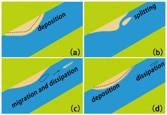
Figure 1.
Diagrammatic sketch of the periodic evolution process of the Jingjiang Sandbank (JJS) including increase, split, migration, and dissipation. (a) increase process of the sandbank; (b) split process of the sandbank; (c) generally migration and dissipation of the split detached bar; (d) totally dissipation of the split detached bar and deposition again of the sandbank.
Due to complex dynamic conditions, evolution processes of river morphology, especially in tidal reaches impacted by the coupling of runoff and tidal current, always show strong nonlinear, and are always analyzed qualitatively and synthetically in general. In this paper, the periodic evolution process of increase, split, migration, and dissipation of the JJS is firstly analyzed by long-term bathymetric measurements. The EOF analysis is firstly employed to study the evolution of the JJS and adjacent riverbed, helping identify and quantify the dominant patterns of the evolution process in space and time from the measured dataset, which provide further understanding of the process of river morphology evolution. It is important to note that the human projects might have changed the evolution pattern of the JJS permanently. Besides, possible explanations of the change of the evolution pattern of the JJS and adjacent riverbed are given.
2. Study Area
The Yangtze River has a total length of 6300 kilometers and a basin area of 1.8 million square kilometers. Different types of sandbanks are distributed along the Yangtze River, due to the difference of hydrodynamic and sediment conditions. Large-scale hydraulic works, such as the constructions of the Three Gorges Dam and the 12.5 m Deep-water Channel Project (DWC Project) of the Yangtze River, have been carried out to support the social development of the national economy, transportation and residents’ safety living along the river. In addition, some local hydrodynamic constructions, such as river damming, ports are distributed along the river.
JJS is located at the entrance of Fujiangsha (FJS) Reach, a multi-branching reach, in the tidal reach of the Yangtze River, as seen in Figure 2. FJS Reach is divided into two branches by FJS Shoal (shown in Figure 2) with the diversion ratios of discharge are 80% for the north branch and 20% for the south branch, and then divided into two branches by Shuangjiansha (SJS) Shoal (shown in Figure 2). The north branch is the main channel with about 3 km wide and 19 km long.
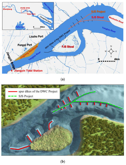
Figure 2.
(a) Location of the study area and the tidal current limit in Yangtze River, and (b) layouts of the two major projects in the study area.
Previous studies have shown that, influenced by the coupling of runoff and tidal current, the location of the tidal current limit of the Yangtze River can be traced back to Zhenjiang (Figure 2) in dry seasons and moved down to the Xijie Port in flood seasons, and FJS Reach is located between the two positions. According to statistics, the location of the tidal current limit varies in the study reach with the discharge of the runoff between 10,000 m3/s and 40,000 m3/s. According to the measurements at Jiangyin tidal station (Figure 2), the tidal level ranges from −1.11 m to 6.67 m with the maximum tidal range of 3.36 m and mean tidal range of 1.78 m, and the maximum flood and ebb velocities are about 0.5 m/s and 1.8 m/s, respectively.
According to the sampling of the riverbed material in recent years, the medium grain size in the FJS Reach ranges from 0.15 to 0.25 mm, which is larger in the deep channel than that in shallows in general. The sediment in the SJS Shoal is finer, with the medium grain size smaller than 0.1 mm. The medium grain size of suspended sediment in the study area ranges from 0.006 to 0.017 mm. In dry seasons, the average suspended sediment concentration (SSC) ranges from 0.043 to 0.226 kg/m3 in flood tides and 0.045 to 0.117 kg/m3 in ebb tides, while in flood seasons, the values are 0.039 to 0.233 kg/m3 in flood tides and 0.061–0.207 kg/m3 in ebb tides.
In the past 10 years, two major projects, including the SJS Project and the spur dikes of DWC Project, have been carried out in the FJS Reach. The SJS Project started at the end of 2010 and finished in May 2012. It includes the construction of three long submerged breakwaters that aims to protect the SJS Shoal from erosion (Figure 2). The DWC Project is a large-scale hydraulic work which covers 283 km from Nanjing to Yangtze Estuary in Yangtze River in China, with a long construction period from 2011 to 2018. Additionally, a series of regulation measures have been carried out in six reaches along Yangtze River to deal with the navigation obstruction problem, one of which is the FJS Reach where the study area is. The engineering measures in the FJS Reach include the construction of a series of spur dikes in the north bank of the FJS Shoal and both sides of the submerged breakwaters of SJS Project (Figure 2) from 2015 to 2018 to improve the flow condition for navigation.
3. Data and Methods
3.1. Data
Studies on the evolution of the sandbank are based on the 17 bathymetric measurements from 1999 to 2017 provided by the Construction Headquarters of Deep-water Channel Project of the Yangtze River.
Hydrological data in this paper are collected from the Hydrologic Data Year Book of China and Sediment Bulletin of China, including the tidal water level and tidal range of Jiangyin tide station from 2003 to 2015, and the runoff and the sediment discharge at Datong hydrometric station, a key hydrological station reflecting the runoff of downstream of Yangtze River, from 2001 to 2018.
3.2. Method
First, a digital elevation model [19] (DEM) of the river section was established to study the general pattern of sandbank evolution. Series of typical parameters were extracted over the years, including the shape of the typical cross-section, the volume of the sandbank, location of the bar peak, etc.
Then, an empirical orthogonal function (EOF) analysis was conducted on the bathymetric dataset to investigate the major evolution patterns of the JJS and the detached bar and to explore the functions of corresponding impacts. EOF analysis has been widely used in ocean science and coastal engineering to investigate the changing patterns of beach profile [20,21,22], coastal sandbank [23], surface temperature [24], sea surface height [25], current profiles [26], terrestrial water storage [27], etc. The methodology of EOF analysis is to seek an expansion of the dataset in terms of a series of eigenfunctions with the same size of the data samples.
In this case, the eigenfunctions are derived from the data of historical elevation data to find both time series and spatial modes. Each of the eigenfunctions consists of a contribution to the water depth as a function of a planimetric position. The 2-dimensional water depth field could be written as
where h is the water depth, X is the planimetric position, t is the time of each measurement, en is the nth eigenfunction, cn is the corresponding temporal coefficient, and N is the total number of eigenfunctions. The eigenfunctions should be independent of each other as
where em is the mth eigenfunction, δnm is the Kronecker delta, where δnm = 1 if n = m and δnm = 0 otherwise.
One of the approaches to calculate the eigenfunctions is the Lagrange multiplier approach [28] as
where λn is the eigenvalues. The matrix A can be calculated by
where nx is the number of water depth points in data sample, nt is the number of the measurement, H is made up of the individual elements of h(X,t), and HT is the transpose of H. The temporal coefficient cn can be calculated with
Each eigenfunction indicates a description of the data accounting for a certain percentage of the data variance. These eigenfunctions functions are usually ranked in descending order of the magnitude of the corresponding eigenvalues which are proportional to the data variance. In this way, the first few eigenfunctions describe the most significant variations.
4. Results and Discussion
4.1. Periodic Evolution of the Sandbank
In this section, the historical evolution of the JJS was analyzed based on 17 bathymetric measurements of the FJS Reach from 1999 to 2017. The earliest bathymetric measurement used in the analysis was measured in 1999, before which some documentation can be found to record the events of the earlier splitting of the JJS. These events are introduced before the data analysis as a historical comparison.
4.1.1. Documented Splitting Events of the JJS before 1999
From 1960 to 1999, there were eight documented splitting events of the JJS which vary in the scale of the detached bars [29]. The splitting location was usually between Pengqi Port and Liuzhu Port. The splitting times and the scales of the detached bars are listed in Table 1. As seen, the periods between the splitting events ranges between two years to seven years. The widths are about 0.5 km and the lengths range from 0.5 to 5 km.

Table 1.
Documented splitting events of the Jingjiang Sandbank (JJS) before 1999.
4.1.2. Analysis of the Evolution of the JJS during 1999 to 2017
From 1999 to 2017, the JJS generally experienced a periodic evolution mode with the stages of increase, split, migration, and dissipation. Nine out of 17 of the bathymetric measurements used in the analysis are plotted in Figure 3 and supplementary information is recorded in Table 2. From 1999 to 2017, the JJS went through six evolution cycles, which can be divided into two categories, complete cycle and splitting cycle, and the periods of the cycles ranged from two years to eight years. A complete cycle means that the detached bar migrates the whole way to SJS Shoal and merged into it, while the splitting cycle means that the detached bar dissipates after splitting away from the JJS. The complete cycles occurred during the period from 2002 to 2010 and 2006 to 2015, and the splitting cycles occurred before 2002 and in 2009, respectively. Overlapping of time can be overserved between two adjacent cycles, i.e., new splitting happens before the dissipation of the last detached bar. The processes of each evolution cycle can be described as follows.
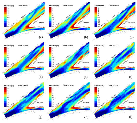
Figure 3.
Nine out of 17 of the digital elevation models (DEMs) based on the bathymetric measurements showing the six evolution cycles with overlapping of time, in which (a) to (b) show 1st cycle, (b) to (e) show 2nd cycle, (d) to (g) show 3rd cycle, (f) to (g) show 4th cycle, (g) to (h) show 5th cycle, and (h) to (i) shows 6th cycle.
Table 2.
Periodic change and splitting events of the JJS from 1999 to 2017.
The splitting of the detached bar of the first cycle happened before 1999. The detached bar was found to migrate downstream with a scale of about 2.5 km (length) × 0.5 km (width). The migration speed was about 0.56 km/y. The splitting of the second cycle took place during 1999 and 2002, after which the detached bar continued to migrate downstream with a speed of about 1.04 km/y, and then merged into the SJS Shoal in 2010. The third cycle started with an inward curving shape formed in the upstream side of JJS in 2006. The splitting finished in 2010 and formed a detached bar with a scale of about 3 km (length) × 0.6 km (width). The detached bar migrated downstream with a speed of 1.25 km/y, and then merged into SJS Shoal in 2015. The fourth and fifth cycles occurred from 2012 to 2016, during which the detached bars dissipated rapidly after splitting from the JJS. The sixth cycle started at the end of 2016 and the splitting process was not yet finished in the last measurement in 2017, (see the half-splitting block of the sandbank in Figure 3).
A typical cross-section at JJS is chosen to see the evolution process during the period from 1999 to 2017 (Figure 4). It can be seen obviously that the shape of the sandbanks changed significantly above elevation −16 m, with the top three scales of the sandbank in January 2001, June 2006, and May 2017 respectively, while the morphology rarely changed in channel.
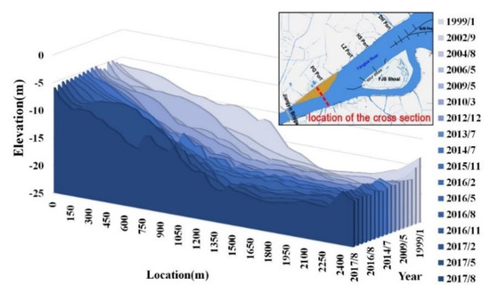
Figure 4.
Shapes of the typical cross section with the maximum width of JJS based on the bathymetric dataset.
To investigate the feature of the migration of the detached bars, they were distinguished from the bathymetry measurements from 1999 to 2017. A total of six individual detached bars were distinguished, and the migration tracks of them are plotted in Figure 5, in which the Y-axis indicates the distance from the peak of the detached bar to the reference point in the upstream of the JJS (Figure 2). As seen, most of the splitting process occurs between Pengqi Port and Liuzhu Port, and only the second and third detached bars reached SJS Shoal before the disappearance. It can also be seen that the overlapping of time is common between adjacent cycles. Another interesting finding is that the period of the evolution cycle seems to reduce to about two to three years after 2012, and the detached bars tend to disappear quickly after splitting away from the JJS. The timing is consistent with the construction of the SJS Project and the following spur dikes of DWC Project, so one of the possible reasons for the shortening of the period of the evolution cycle and the rapid dissipation of the detached bar is the construction of the projects. If this explanation is right, it means that the pattern of the evolution cycle has been changed permanently by the construction of the two projects. However, the existing three observed evolution cycles are inadequate to draw a convincing conclusion, and future works are expected.
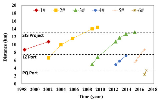
Figure 5.
Migration tracks of the detached bars, including two complete cycle, three splitting cycle and one unfinished cycle.
Except for the migration of the detached bars, the periodic evolution of the sandbank itself is also concerned. To investigate the change of the scale of the JJS, the historical volumes of the JJS were calculated and are plotted in Figure 6. The volume of the JJS is defined as the volume of the sediment that is above −16 m in the area of the JJS. From 1999 to 2017, the volume change of the JJS seemed to have two periodic cycles, during each of which the volume of the JJS experienced a decreasing-and-increasing process. However, the scope of the volume change seemed to decrease significantly after 2012. Like the change of the evolution pattern of the detached bar, the decrease of the scope of the volume change of the sandbank can also be explained by the construction of the two projects. However, this explanation is given tentatively due to limited field data, and future works are expected.
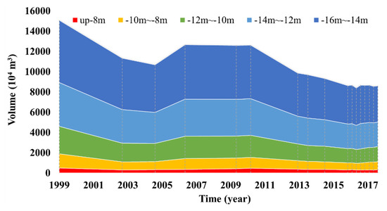
Figure 6.
The historical volumes of the main body of JJS above elevation −16 m.
4.2. Major Patterns of the Sandbank Evolution
To investigate the major patterns of the complex evolution of JJS, an empirical orthogonal function (EOF) analysis was conducted on the bathymetric dataset of the JJS and adjacent riverbed. The area of EOF analysis is illustrated in Figure 7. The area contains the JJS and its downstream reach. The spur dikes are excluded to reduce the variance impact near artificial structures.
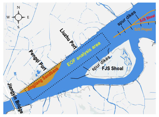
Figure 7.
The area for empirical orthogonal function (EOF) analysis. The spur dikes are excluded to reduce the variance impact near artificial structures.
A total of 17 bathymetric measurements from 1999 to 2017 were interpolated onto a regular 50 m × 50 m grid using linear and then used in the EOF analysis. The result shows that more than 96% (Table 3) of the data variation is captured by the first four eigenfunctions. Additionally, the first four eigenfunctions are plotted together with the corresponding historical changes of the temporal coefficients in Figure 8.
Table 3.
Percentage of the total variability represented by the first four eigenfunctions of EOF analysis.
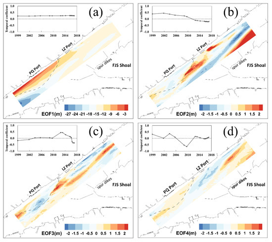
Figure 8.
First four eigenfunctions (spatial modes) and the corresponding temporal coefficients in the upper left corner. The dotted line indicates the approximate area of the JJS. The color indicates the values of the corresponding eigenfunctions, which is the same size of the EOF analysis area, the unit is meter, which is the same as the analyzed data, i.e., the bathymetry. (a) the first eigenfunction and the corresponding temporal coefficient; (b) the second eigenfunction and the corresponding temporal coefficient; (c) the third eigenfunction and the corresponding temporal coefficient; (d) the fouth eigenfunction and the corresponding temporal coefficient.
4.2.1. Sensitivity Analysis of EOF
To study the sensitivity of the results of EOF analysis to the number of samples, the eigenfunctions were also calculated with different numbers (15 and 16) of bathymetric measurements, and deviations of the eigenfunctions to the eigenfunctions calculated with all 17 bathymetric measurements are calculated. The deviations are calculated by the following formula:
where is the nth normalized eigenfunction calculated with k bathymetric measurements, N is the total number of grid points in the analysis area.
Results show that, compared with the eigenfunctions calculated with all 17 measurements , the deviations of the eigenfunctions maintain in a small level, i.e., the deviation of ranged from 0.037% to 0.56%, the deviation of ranged from 1.19% to 2.57% the deviation of ranged from 0.32% to 1.36%, the deviation of ranged from 0.21% to 10.82%, the deviation of ranged from 0.46% to 0.88%, the deviation of ranged from 1.74% to 3.30% the deviation of ranged from 1.42% to 1.50%, and the deviation of ranged from 0.68% to 11.40%. The deviations are plotted in Figure 9. As seen, for most of the cases the deviation is smaller than 3.5%, for only one case of and one case of the deviations were between 10% and 12%. The reason of the relatively large deviations in these two cases is the remove of a data (the measurement in May 2009) that made significant contribution to the variance. Generally, removing one or two data measurements yields limited influence on the eigenfunctions, indicating that the results of the EOF analysis based on existing bathymetric measurements can reflects the evolution pattern of the JJS and adjacent riverbed.
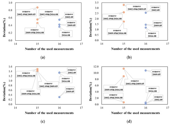
Figure 9.
The deviations of eigenfunctions induced by different numbers of the bathymetric measurements, comparing with the results of the total 17 bathymetric measurements: (a) the deviation of EOF 1; (b) the deviation of EOF 2; (c) the deviation of EOF 3; and (d) the deviation of EOF 4.
4.2.2. The First Four Major Patterns
As noted in most of the existing studies, the first eigenfunction corresponds to the time-averaged bathymetry, and it can be labeled as the mean elevation function with the corresponding temporal coefficient basically unchanged. It represented 86.45% of the data variance.
The second eigenfunction corresponds to the long-term change of the pattern of elevation, representing 7.16% of the data variance. As it can be seen, the temporal coefficient turned from positive to negative after 2012, indicating that the detached bar that split from the JJS became strongly active. In addition, the disappearance of the sand ridge in the east part of the study area and the siltation in the north of the sand ridge indicates that sand ridge shifted north. The sand ridge can be found existing in Figure 3a to Figure 3d during the period from 1999 to 2006, and disappearing in Figure 3e in 2009. In Figure 3f to Figure 3i from 2012 to 2017, the sand ridge cannot be found. A highly possible explanation of this pattern is the construction of the SJS Project and the spur dikes of the DWC Project, which indicates that the human projects might have changed the evolution pattern of the JJS permanently. Spur dikes at the north side of the FJS Shoal increase the waterpower outer edges of the heads the spur dikes, forcing the mainstream moving to the north. In addition, the influence of the LZ port can also be reflected in the second eigenfunction. As seen in Figure 8b, a significant large vale of the second eigenfunction can be found at and downstream of the LZ port.
The third eigenfunction reflects the long-term periodic change of the JJS itself and the detached bar with a period of 18 years, representing 2.02% of the data variance. A trough can be found in the middle of the JJS and an obvious wave of the water depth can be found in the downstream of the JJS. According to the long-term periodic change of the temporal coefficient, the JJS itself experiences a siltation–erosion–siltation process, while the wave of the water depth propagates downstream, which reflects the periodic splitting-away and downstream movement of the detached bar. Those changing patterns of the shape of the JJS can be confirmed in the historical measurements of the elevation shown in Figure 3, e.g., the middle of the JJS had a relatively large width in 1999 and 2010, while the width was smaller after 2012. The temporal coefficient of the third eigenfunction turned from negative to positive around 2003 and changed significantly after 2012, which implies closely associated with the runoff conditions, including discharge and sediment. Statistics from the hydrometric station of Datong show a decrease of suspended sediment discharge since 2003 and a significant change around 2011 after the reservoir filling of the Three Gorges Dam, which indicates a promotion of sediment carrying capacity (Figure 10). However, sediment conditions upstream of the JJS should have a more immediate effect. Future works are expected to confirm the impact of the runoff.
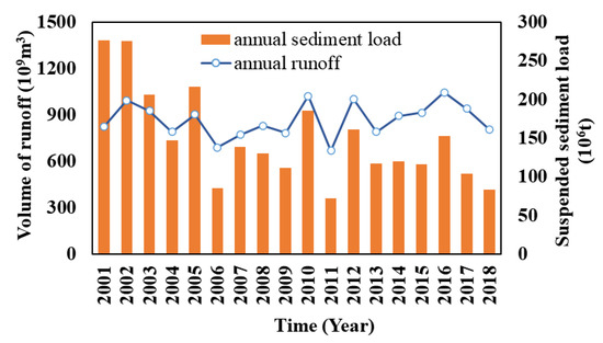
Figure 10.
Annual runoff and suspended sediment load recorded at the hydrometric station of Datong.
The fourth eigenfunction shows a rip adjacent to the north bank of the river and between the JJS and downstream area, representing 1.25% of the data variance. In addition, an obvious wave of the water depth can be found in the downstream of the JJS. With the periodic change of the corresponding temporal coefficient, the wave of the water depth propagates downstream, which reflects the periodic splitting-away and downstream movement of the detached bar, with a period of eight years. As shown in Figure 11, the temporal coefficient of the fourth eigenfunction shows a similar trend to the change of the annual maximum tidal range which partially reflects the interannual variability of the tidal current. Therefore, the fourth eigenfunction might be related to the tidal current. However, due to a limited time range of measurement, the relationship between the fourth pattern and tidal current is expected to be confirmed in future works.
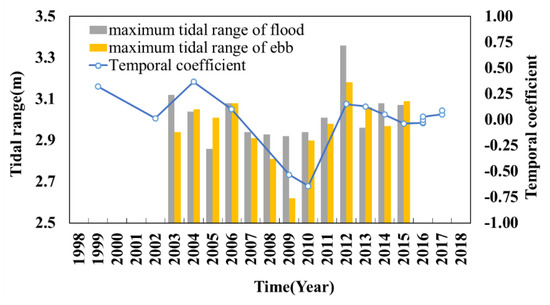
Figure 11.
Annual maximum tidal range of flood and ebb respectively, and the fourth temporal coefficient.
5. Conclusions
The JJS is a marginal sandbank located on the left bank of the FJS Reach in the Yangtze River. It experiences a periodic evolution process of increase, split, migration, and dissipation, which affect the morphology feature, the channel depth, the levee safety, and other aspects of the FJS Reach. In this paper, the periodic evolution of the JJS was investigated on the base of 17 field measurements of the elevation of the FJS Reach from 1999 to 2017.
The evolution pattern of the JJS and the adjacent riverbed was firstly discussed according to the measured elevation changes. The six cycles of the evolution process of the JJS and adjacent riverbed and during 1999 to 2017 were described. It was found that the overlapping of time is common between adjacent evolution cycles. The detached bars were distinguished from the elevation measurements and the migration tracks were discussed. It was found that after 2012 the period of the evolution cycle reduced to about two to three years and the detached bars seemed to disappear quickly after splitting away, the reason of which might be the construction of the SJS Project and the spur dikes of DWC Project. The volumes of the JJS in each measurement of elevation were calculated and the historical change of the volumes was discussed. The scope of the volume change also decreased significantly after the year of 2012, which can also be explained by the construction of the two projects. According to the changes of the evolution feature of the detached bar and the JJS itself, the construction of the two projects might have changed the evolution pattern of the JJS permanently. However, due to the limited time range of measurement after the construction of the two projects, future works are expected to investigate the effects of the two projects.
EOF analysis was conducted on the historical elevation of the JJS and adjacent riverbed. The first four eigenfunctions correspond to the mean elevation, the long-term change of the pattern of bathymetry, a periodic change of the JJS itself and downstream migration of the split detached bar with a period of 18 years, and the periodic change of the rip at the back of JJS with a period of eight years. The last two of the eigenfunctions with the corresponding temporal coefficient indicate proper runoff-dominated and tide-dominated changes of the JJSs, respectively, which are expected to be further confirmed in future works. In addition, according to both the historical analysis and EOF analysis, the current work also highlights that the construction of two waterway regulation projects in the multi-branching reach might have changed the evolution pattern of the JJS permanently. However, due to a limited time range of measurement after the construction of the two projects, future works are expected to investigate the effects of the two projects.
Author Contributions
Conceptualization, Y.H. and M.C.; methodology, Y.H.; software, Y.H.; validation, Y.W., A.M.; formal analysis, Y.H.; investigation, A.M. and Y.W.; resources, A.M.; data curation, Y.H.; writing—original draft preparation, Y.H.; writing—review and editing, Y.H., M.C. and X.D.; visualization, Y.H.; supervision, M.C. and A.M.; project administration, M.C.; funding acquisition, M.C. All authors have read and agreed to the published version of the manuscript.
Funding
This research was funded by National Key R&D Program of China, 2016YFC0402107.
Acknowledgments
We would like to thank the Construction Headquarters of Deep-water Channel Project of the Yangtze River for providing bathymetric dataset and other technical support.
Conflicts of Interest
The authors declare no conflict of interest.
References
- Feng, L.-H.; Ma, Y.-J. Evolution of tidal flats in China and ecological exploitation of tidal flat resources. Environ. Earth Sci. 2012, 67, 1639–1649. [Google Scholar] [CrossRef]
- Wang, Y.P.; Gao, S.; Jia, J.; Thompson, C.E.; Gao, J.; Yang, Y. Sediment transport over an accretional intertidal flat with influences of reclamation, Jiangsu coast, China. Mar. Geol. 2012, 291, 147–161. [Google Scholar] [CrossRef]
- Anthony, E.J.; Marriner, N.; Morhange, C. Human influence and the changing geomorphology of Mediterranean deltas and coasts over the last 6000 years: From progradation to destruction phase? Earth-Sci. Rev. 2014, 139, 336–361. [Google Scholar] [CrossRef]
- Deng, Y.; Cao, M.-X.; Ma, A.-X.; Hu, Y.; Chang, L.-H. Mechanism study on the impacts of hydraulic alteration on fish habitat induced by spur dikes in a tidal reach. Ecol. Eng. 2019, 134, 78–92. [Google Scholar] [CrossRef]
- Shi, Q.; Zhang, X.F.; Xu, Q.X. Experiment study on the evolution of alternate bars in straight channel under different discharge and sediment conditions. J. Yangtze River Sci. Res. Inst. 2019, 5, 1–10. [Google Scholar] [CrossRef]
- Eekhout, J.; Hoitink, A.J.F.; Mosselman, E. Field experiment on alternate bar development in a straight sand-bed stream. Water Resour. Res. 2013, 49, 8357–8369. [Google Scholar] [CrossRef]
- Brivio, L.; Ghinassi, M.; D’Alpaos, A.; Finotello, A.; Fontana, A.; Roner, M.; Howes, N. Aggradation and lateral migration shaping geometry of a tidal point bar: An example from salt marshes of the Northern Venice Lagoon (Italy). Sediment. Geol. 2016, 343, 141–155. [Google Scholar] [CrossRef]
- Dietrich, W.E.; Smith, J.D. Influence of the point bar on flow through curved channels. Water Resour. Res. 1983, 19, 1173–1192. [Google Scholar] [CrossRef]
- Wei, W.; Dai, Z.J.; Mei, X.F.; Gao, S.; Liu, J.P. Multi-decadal morpho-sedimentary dynamics of the largest Changjiang estuarine marginal shoal: Causes and implications. Land Degrad. Dev. 2019, 30, 2048–2063. [Google Scholar] [CrossRef]
- Durkin, P.R.; Hubbard, S.M.; Boyd, R.L.; Leckie, D.A. Stratigraphic expression of intra-point-bar erosion and rotation. J. Sediment Res. 2015, 85, 1238–1257. [Google Scholar] [CrossRef]
- Moody, J.A.; Meade, R.H. Ontogeny of point bars on a river in a cold semi-arid climate. GSA Bull. 2014, 126, 1301–1316. [Google Scholar] [CrossRef]
- Wu, C.; Ullah, M.S.; Lu, J.; Bhattacharya, J.P. Formation of point bars through rising and falling flood stages: Evidence from bar morphology, sediment transport and bed shear stress. Sedimentology 2016, 63, 1458–1473. [Google Scholar] [CrossRef]
- Slowik, M. Sedimentary record of point bar formation in laterally migrating anabranching and single-channel meandering rivers (The Obra Valley, Poland). Z. Geomorphol. 2016, 60, 259–279. [Google Scholar] [CrossRef]
- Kasvi, E.; Vaaja, M.; Alho, P.; Hyyppä, H.; Hyyppä, J.; Kaartinen, H.; Kukko, A. Morphological changes on meander point bars associated with flow structure at different discharges. Earth Surf. Process Landf. 2013, 38, 577–590. [Google Scholar] [CrossRef]
- Maatooq, J.S.; Hameed, L. Identifying the pool-point bar location based on experimental investigation. J. Water Land Dev. 2019, 43, 106–112. [Google Scholar] [CrossRef]
- Zhang, Y.; Cai, X.; Yang, C.; Li, E.; Song, X.; Ban, X. Long-Term (1986–2018) evolution of channel bars in response to combined effects of cascade reservoirs in the middle reaches of the Hanjiang River. Water 2019, 12, 136. [Google Scholar] [CrossRef]
- Dai, Z.; Fagherazzi, S.; Mei, X.; Gao, J. Decline in suspended sediment concentration delivered by the Changjiang (Yangtze) River into the East China Sea between 1956 and 2013. Geomorphology 2016, 268, 123–132. [Google Scholar] [CrossRef]
- Liang, H.; Kuang, C.; Gu, J.; Ma, Y.; Chen, K.; Liu, X. Tidal asymmetry changes in a shallow mud estuary by a restoration project. J. Ocean Univ. China 2019, 18, 339–348. [Google Scholar] [CrossRef]
- Tang, G.A. Progress of DEM and digital terrain analysis in China. ACTA Geogr. Sin. 2014, 69, 1305–1325. [Google Scholar] [CrossRef]
- Taaouati, M.; Parisi, P.; Passoni, G.; Lopez-Garcia, P.; Romero-Cozar, J.; Anfuso, G.; Vidal, J.; Muñoz-Perez, J. Influence of a reef flat on beach profiles along the Atlantic coast of Morocco. Water 2020, 12, 790. [Google Scholar] [CrossRef]
- Winant, C.D.; Inman, D.L.; Nordstrom, C.E. Description of seasonal beach changes using empirical eigenfunctions. J. Geophys. Res. Space Phys. 1975, 80, 1979–1986. [Google Scholar] [CrossRef]
- Pan, Y.; Kuang, C.; Zhang, J.; Chen, Y.; Mao, X.; Ma, Y.; Zhang, Y.; Yang, Y.; Qiu, R. Postnourishment evolution of beach profiles in a low-energy sandy beach with a submerged berm. J. Waterw. Port Coast. Ocean Eng. 2017, 143, 05017001. [Google Scholar] [CrossRef]
- Reeve, D.E.; Horrillo-Caraballo, J.M.; Magar, V. Statistical analysis and forecasts of long-term sandbank evolution at Great Yarmouth, UK. Estuar. Coast. Shelf Sci. 2008, 79, 387–399. [Google Scholar] [CrossRef]
- Jiang, N.; Zhu, C. Asymmetric changes of ENSO diversity modulated by the cold tongue mode under recent global warming. Geophys. Res. Lett. 2018, 45, 12506–12513. [Google Scholar] [CrossRef]
- Lin, Y.H.; Greatbatch, R.J.; Sheng, J. The influence of Gulf of Mexico Loop Current intrusion on the transport of the Florida Current. Ocean Dyn. 2010, 60, 1075–1084. [Google Scholar] [CrossRef]
- Forristall, G.Z.; Cooper, C.K. Design current profiles using empirical orthogonal function (EOF) and inverse FORM methods. In Proceedings of the 1997 29th Annual Offshore Technology Conference, Houston, TX, USA, 5–8 May 1997. [Google Scholar]
- Becker, M.; Meyssignac, B.; Xavier, L.; Cazenave, A.; Alkama, R.; Decharme, B. Past terrestrial water storage (1980–2008) in the Amazon Basin reconstructed from GRACE and in situ river gauging data. Hydrol. Earth Syst. Sci. 2011, 15, 533–546. [Google Scholar] [CrossRef]
- Miller, J.; Dean, R.G. Shoreline variability via empirical orthogonal function analysis: Part I temporal and spatial characteristics. Coast. Eng. 2007, 54, 111–131. [Google Scholar] [CrossRef]
- Wen, Y.C.; Xu, H.; Xia, Y.F.; Zhang, S.Z. Study on the evolution properties and factors of the Jingjiang Sandbank under new flow-sediment environment. Yangtze River 2018, 49, 6–10. [Google Scholar] [CrossRef]


© 2020 by the authors. Licensee MDPI, Basel, Switzerland. This article is an open access article distributed under the terms and conditions of the Creative Commons Attribution (CC BY) license (http://creativecommons.org/licenses/by/4.0/).