Article

Understanding Future Water Challenges in a Highly Regulated Indian River Basin—Modelling the Impact of Climate Change on the Hydrology of the Upper Narmada

1
UK Centre for Ecology & Hydrology, Wallingford OX10 8BB, UK
2
National Institute of Hydrology, Roorkee 247667, India
3
Civil Engineering Department, IIT, Roorkee 247667, India
4
Department of Irrigation and Water Management, Bangladesh Agricultural University, Mymensingh 2202, Bangladesh
*
Author to whom correspondence should be addressed.
Water 2020, 12(6), 1762; https://doi.org/10.3390/w12061762
Submission received: 13 May 2020 / Revised: 12 June 2020 / Accepted: 16 June 2020 / Published: 20 June 2020
(This article belongs to the Section Water Use and Scarcity)

Abstract

:
The Narmada river basin is a highly regulated catchment in central India, supporting a population of over 16 million people. In such extensively modified hydrological systems, the influence of anthropogenic alterations is often underrepresented or excluded entirely by large-scale hydrological models. The Global Water Availability Assessment (GWAVA) model is applied to the Upper Narmada, with all major dams, water abstractions and irrigation command areas included, which allows for the development of a holistic methodology for the assessment of water resources in the basin. The model is driven with 17 Global Circulation Models (GCMs) from the Coupled Model Intercomparison Project Phase 5 (CMIP5) ensemble to assess the impact of climate change on water resources in the basin for the period 2031–2060. The study finds that the hydrological regime within the basin is likely to intensify over the next half-century as a result of future climate change, causing long-term increases in monsoon season flow across the Upper Narmada. Climate is expected to have little impact on dry season flows, in comparison to water demand intensification over the same period, which may lead to increased water stress in parts of the basin.

1. Introduction

The management of water resources across the world is becoming an increasingly challenging task, owing to the impending threats of climate change, rapid urbanisation, growing population, and unsustainable exploitation. In few places is the impact of climate change and human intervention on water resources more prominent than in India [1,2,3]. Many of India’s major rivers are impounded along their course for multifarious purposes [4]. The semi-arid and arid regions of the country are facing multiple challenges of water scarcity and deteriorating water quality. The National Water Policy of India [5] recognises the need for a national perspective on the development and management of water resources in the context of a changing climate and anthropogenic influences, in order to conserve the already scarce water resources in an integrated and environmentally sound way. Ensuring the food security of a burgeoning population will further increase water requirements from systems that are already under stress due to the conflicting demands of multiple users, including domestic, agricultural, energy generation, industrial and environmental [1,6].
Future climate change will likely lead to increases in average temperatures across south-east Asia over the next century, along with changes in rainfall distribution, magnitude and intensity [7,8]. Work by Mukherjee et al. [9] showed that the intensity of extreme rainfall events in India has increased over recent decades. Episodes of intense precipitation are expected to become more commonplace, with more overall rainfall being produced for any given storm. The year-to-year variability of the monsoon ultimately shapes the extremity of hydrological events, from severe droughts through to devastating floods. This has a direct effect on water storage and utilisation [2,10]; at present, around 45% of the average annual precipitation in India reaches the sea as runoff [2,11], whilst drought events become ever more prevalent [10,12].
Future water availability will be affected not only by climate change, but also by growing demands across user sectors. The domestic, agricultural and industrial sectors are projected to increase water use over the next half century [13]. Water demand is growing fast due to rapid population growth and economic activity, and is not being matched by water supply [14]. If such trends continue, many regions of India will face critical levels of water scarcity during the dry season exacerbated by climate change, causing conflicts amongst sectors and regions, and affecting food supply and livelihoods [1,2,13,15]. The sustainable management of water resources across India, and the means to achieve this, is imperative going forward [16]; water availability and appropriate allocation are therefore likely to become an even more prominent issue in the near future [17,18].
Large-scale hydrological models are increasingly used for the simulation of water availability and extreme events, including droughts and floods [19,20,21]. This facilitates scenario-based analysis, wherein the impacts of climate change, land use change and water resource development activities can be comprehensively evaluated for the formulation of appropriate adaptation and mitigation strategies [22,23,24,25]. The need for robust, coherent river basin management plans has thus become a driving force behind the use and development of large-scale hydrological models in understanding how basin hydrology will be affected by naturally and human-induced changes, and the influence of intersectoral resource linkages on water availability [1,26,27,28].
Large-scale hydrological modelling does, however, involve many challenges [21,29,30,31,32,33]. The high spatial variability of input data such as land use, soil properties and topography across large catchments, the uncertainties in driving climate data, along with the difficulties of capturing micro-watershed scale hydrological processes and the ever-growing number of anthropogenic interventions incorporated at different periods in many river basins, directly affect the hydrological regime. This can make the accurate representation of river basins extremely difficult. For example, global runoff estimations can differ by as much as 70% between studies for individual continents [34]. Due to the highly influenced nature of many of India’s major river basins, including the presence of dams and water abstractions, the modelling of Indian water resources becomes extremely challenging [35]. The acquisition of reliable, relevant data poses a major challenge, where information on river flow and interventions is often not widely available. In light of this, a more holistic methodology and long-term assessment are needed for water resources management across many Indian catchments [36]. Large-scale model application in India ideally needs to incorporate anthropogenic basin interventions, such as water resource development projects, and account for population growth and demand from other water users [37], including industry and irrigated agriculture.
This study applies the Global Water Availability Assessment (GWAVA) model, including human interventions, to the Upper Narmada basin, India. The objectives of the study are (1) to test the suitability of a large-scale grid-based water resources model in replicating the hydrology of the heavily impacted Upper Narmada, and (2) to assess the impacts of future climate change on the hydrological regime and future water resources of the basin.

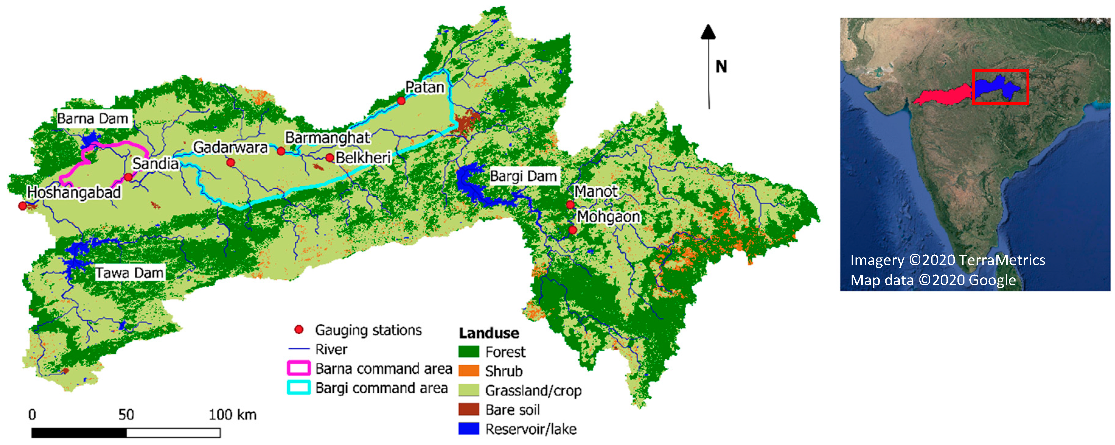
2. Materials and Methods

The Narmada river basin is a highly regulated system, traversing the states of Chhattisgarh, Madhya Pradesh, Maharashtra and Gujarat, supporting a population of over 16 million people [5]. The main river reach, the Narmada river, is the largest west-flowing river in India, with a drainage area of 98,796 km2 [5,38]. The majority of the basin sits between 300 m and 500 m in elevation, with extremes in the steep hills of the upper tributaries of the Maikala to the east, reaching 1317 m in elevation, through to the west coast where the river drains into the Arabian sea through the Gulf of Khambhat [39]. The Narmada basin is subject to a tropical monsoon climate, with the south-west monsoon between July and September the major controlling factor of river discharge. The monsoon supplies over 75% of the basin’s annual precipitation, with a rainfall gradient of 650 mm per annum to more than 1400 mm per annum in the upper regions. This climate also leads to two distinct growing seasons, the Kharif (monsoon season) and the Rabi (non-monsoon season). Average temperatures range from 18 °C to 32 °C in January and May, respectively [38].
The Narmada is an example of a river basin facing numerous managerial challenges with sectoral competition for water. Over half of the catchment is used for agricultural production, with the majority of this designated as irrigation command area. There are over 4000 water-related interventions in operation across the basin, with more than 250 dams [4]. The dams vary in purpose and size, from supplying water for irrigation through to the generation of hydropower and supply for consumptive and domestic use. Previous studies have applied models for the establishment of hydrological parameters for the Narmada basin for streamflow simulation, and for the assessment of the impacts of climate change on river basin hydrology [3,40,41,42]. However, the influence of anthropogenic modifications present in the basin is often under-represented or excluded entirely, therefore providing little information on plausible future states of water resources for water practitioners and stakeholders [3].
This study models the water resources of the upper part of the Narmada basin, from the most eastern extent of the basin to the downstream gauging station at Hoshangabad, draining 44,548 km2 (Figure 1). Major dams, abstractions, irrigation practices and corresponding canal networks are included to gain an improved representation of the impact of future climate change on water resources in the Upper Narmada basin.
GWAVA is a large-scale hydrological model developed to provide a robust methodology for the assessment of water resources at the regional to global scale [44]. It is a gridded, semi-distributed model, incorporating key elements of river infrastructure and water demands. The model provides a comparison of surface water availability and demand on a cell-by-cell basis, often spanning across large river basins through to regions. Previous studies have therefore seen GWAVA applied at spatial resolutions of between 0.5° × 0.5° (approximately 50 km × 50 km) and finer resolutions of 5′ × 5′ (approximately 7 km × 9 km) [44,45]. The GWAVA model includes modules for the inclusion of water demands and returns across the domestic, agricultural and industrial sectors. The routing of water through lakes and reservoirs is also accounted for, including basic operational rules specific to reservoir purpose, i.e., irrigation, hydropower and environmental flows. Runoff generation in GWAVA is derived through the probability distributed model (PDM) [46,47]. Surface runoff is routed through a linear reservoir, whilst subsurface flow is routed through a nonlinear reservoir, providing appropriate lag times based on the nature of the processes for each of the hydrological pathways. Runoff generated by each cell is then accumulated along the gridded river drainage network. Evaporation losses from the cell occur at the potential rate when soil moisture levels are above field capacity, decreasing to a rate proportional to the ratio of soil moisture to soil depth below field capacity, until no water can be extracted when moisture levels reach the wilting point. An empirical interception loss model is applied to tree and shrub classes [48]. Field capacity, maximum saturation capacity and wilting point are linked to the physical characteristics of land cover and soil texture class.
For this study, the Upper Narmada basin was divided into 318 grid cells of 0.125° × 0.125° (approximately 13 km × 13 km). This resolution was chosen largely as a consequence of data availability and suitability for the analysis of regional water resource assessment. See Table 1 for the data sources used in the study.
Contributions to runoff generation are reduced by the proportion of cells that is a lake, wetland or reservoir. Lakes, reservoirs and wetlands are taken into account in a broadly similar way, with each being treated as a tank and outflow generated as a function of average storage and monthly inflow. Reservoir operations can be tailored depending on data availability. Irrigation canal networks and pipelines are incorporated, transferring water from water bodies to any grid cell within the model domain, or alternatively to outside of the watershed. For the model application in the Upper Narmada, reservoir operations were based on annual releases disaggregated in to seasonal regimes, including those releases via irrigation canals to command areas. Reservoir operations were included for the major Tawa, Bargi and Barna dams (Figure 1), and simplified to enable their inclusion in the model configuration. Detailed water transfers out of the basin were also incorporated, including those running from the Tawa Dam to the adjacent Ganga basin. See Table 2 for details of the three reservoirs included in the model.
Rural and urban domestic water use in GWAVA is determined based on the human population per grid cell and per capita water demand. Estimates of return flows and, where relevant, network losses, are included to provide gross amount of water abstracted, i.e., consumptive use. Domestic water demands are assumed to be constant throughout the year. For this study, the Indian population census [56] provided information at the taluk level (i.e., an administrative division), which were then classified as urban or rural based upon their locality to major cities and towns. Additional agricultural water demands arise from livestock watering, estimated by the number of cattle, sheep, pigs and small ruminants and a per head water requirement. Livestock water demands are assumed to be constant throughout the year. Information on these requirements in the Upper Narmada basin were gathered from the Indian Livestock Census [62], with consumption applied via estimates from the Food and Agricultural Organization (FAO) [57].
Crop water demands in GWAVA are modelled using the FAO crop water requirement model [58], based on established crop coefficients that vary throughout the growing season [63]. Irrigation efficiencies are included to provide an estimate of the gross amounts of water abstracted. For this study, surface irrigation methodologies were assumed via the use of canals and their offtakes. In the Upper Narmada, the two main command areas are those supplied by the Bargi and Barna reservoirs (Figure 1), covering an area of 1570 km2 and 579 km2, respectively. The command area for the Tawa is located downstream of the Upper Narmada basin; therefore, any water allocation from this reservoir was treated as a water transfer to outside of the model domain. The Rabi and Kharif growing seasons were represented on an annual basis, with crop rotation based on information gathered by the National Institute of Hydrology (NIH) for wheat and paddy [59].
The model application for this study is primarily concerned with assessing the impact of climate change on surface water availability. Groundwater reserves are drawn upon to meet grid cell demands based on a ratio split between surface water and groundwater withdrawals. The quantifiable impact on groundwater reserves was not assessed in this study. Multi-site model calibration was conducted at a daily time step using an automatic calibration routine, based on Nelder and Mead [64]. Calibration was undertaken against mean daily flow data for eight gauging stations in the Upper Narmada basin (Figure 2 and Table 3), obtained from India-WRIS [52]. The selection of these stations was based upon the completeness of their records and their location within the basin.
A general overview of the modelling approach used in this study is displayed in Figure 3. IMD (India Meteorological Department)/NCC (National Climate Centre) gridded rainfall and temperature data were used to drive the model for calibration and validation [53,66]. Potential Evapotranspiration (PET) was calculated from IMD temperature data using the FAO56 Hargreaves methodology [63]. Only years following the construction of all three dams (Table 2) were chosen for calibration and validation, to gain a better understanding of their impact on the hydrology in the Upper Narmada, and to represent their influence on the key hydrological processes within the basin. Following automatic calibration, model parameters were explored through visual inspection of modelled and observed hydrographs. Model output was aggregated to a monthly time step and assessed using statistical measures, including the Nash–Sutcliffe coefficient (NSE), the Pearson correlation coefficient (r) and the percentage deviation in simulated mean flow from the observed mean flow (Dv) [67]. Model performance statistics for the calibration and validation periods are shown in Table 4.
The model generally performs well during both calibration and validation periods in reproducing monthly river discharges at the eight gauging stations. NSE metrics range from 0.64 to 0.96, with all but the validation period at Gadarwara categorised as “very good” to “excellent”, along with r values ranging from 0.88–0.98. Dv is again classed as “very good” to “excellent” for both calibration and validation at all but two of the eight stations, these being Patan and Belkheri. These stations both overestimate total flows, indicating that the processes present in these catchments are not as well represented as at the other stations. This trend to overestimate total flows is, however, also evident at some other gauges, albeit to a lesser extent. This may partly be a result of the many small-scale anthropogenic influences, such as check dams, field bunds and farm ponds present throughout the basin, which are not adequately represented in the model set-up, largely due to a lack of data being available for these features. Such structures are likely to attenuate flow and reduce quick flow response [2], promoting groundwater recharge and therefore slower flow pathways. Such structures also lead to greater rates of actual evapotranspiration (AET) due to the resultant bodies of open water, and therefore increase water losses from the system. Despite this, the annual hydrological regime is well represented by the model, with the timing and magnitude of flow for the south-west monsoon being captured reasonably well at all sites for both the calibration and validation periods, as can be seen in Figure 4. The metrics for simulated model flow suggest a good fit to the observed discharge data, especially when taking in to account the extent of modification along the river reaches of the Narmada and the relatively coarse temporal and spatial resolution being used. As such, the GWAVA application for the Upper Narmada was demonstrated to be suitable for exploring the future impacts of climate change on the water resources of the basin with the current calibrated parameter set.
To provide simulated discharge for a 30-year baseline period, the GWAVA model was forced with gridded IMD climate data, as described above, for the period 1981–2010. For future river flow projections, GWAVA was forced with GCMs included in CMIP5 for a future period of 2031–2060, under a RCP 4.5 scenario (Representative Concentration Pathway that can produce 4.5 W m−2 radiative forcing by the end of 21st Century). See Table 5 for details of the GCMs used in this study.
The CMIP5 GCM data were downscaled to a spatial resolution of 0.25° × 0.25° using the Bias-Correction Spatial Disaggregation (BCSD) method [68], following the approach by Rahman [69]. An additional stage of bias correction was subsequently undertaken, where the GCM bias for the historical period was assessed in relation to the IMD/NCC data, and this information used to correct the future GCM projections. The final GCMs chosen for the study are exemplars from the CMIP5 database, providing different representations of global climate features [70].

3. Results

3.1. Basin Climatology

Projected changes in future climate for the period 2031–2060 were assessed relative to the baseline period of 1981–2010. Mean annual precipitation projections across all GCMs show an increase at all sites by 2060, with a median increase of between 13.7% at Barmanghat and 18.1% at Hoshangabad (Figure 5a). There is considerable variation in mean annual precipitation between the GCMs, with IPSL-CM5A-LR predicting increases of over 40% at Sandia, Gadarwara and Hoshangabad. Beyond these more extreme changes, the Interquartile Range (IQR) is relatively small, varying between 13% at Hoshangabad and 16.6% at Patan. Only three out of seventeen models across all sites show a decrease in annual precipitation, these being at Belkheri, Gadarwara and Patan.
Figure 5b shows the majority of GCMs projecting an increase in precipitation. The baseline median of the annual means (1136.61 mm) is exceeded by all models, the largest increase predicted by the IPSL-CM5A-LR model at 1560.54 mm (37%). Interannual variation is relatively large and is also predicted to increase by all of the GCMs when compared to the baseline IQR of 242.19 mm. The IPSL models again show the largest variation in mean annual precipitation, with IQR values of 872.75 mm (260.3%) for IPSL-CM5A-LR and 902.56 mm (272.6%) for IPSL-CM5A-MR.
Changes in PET within the basin are less pronounced, although the annual mean across all GCMs increases at each of the eight sites (Figure 5c). Median values range from a 2.5% increase at Patan, through to a 4.6% increase at Manot. The spread in mean annual values across all sites is relatively small, with the largest IQR being displayed at Belkheri. Total PET variation between years within models is more pronounced (Figure 5d). The median baseline PET from 1981–2010 of 1758.63 mm is exceeded by all of the GCM models, the most substantial increase displayed by the CanESM2 model with a median of 1879.39 mm (6% increase). The variation between GCMs is less marked than for future precipitation, with the lowest median value of 1805.37 mm being displayed by the CNRM-CM5 model. The IQR between models is also less pronounced, ranging from 40.06 mm for the CCSM4, through to 122.45 mm for the IPSL-ESM2-MR model, compared to a baseline IQR of 73.29 mm; a −45% and 67% change, respectively. Despite variation between models for both future precipitation and PET, the direction of change remains consistent throughout for the majority of years from 2031–2060, with increases in precipitation and PET projected at all eight gauging sites.

3.2. Simulated Scenario Discharge

All projected changes in flow under the RCP 4.5 scenario are assessed relative to the baseline period of 1981–2010. Figure 6 displays simulated river regimes of mean monthly discharge at the eight gauging stations for each of the seventeen GCMs, along with those for the baseline period and ensemble mean. It is during the months of the prevailing south-west monsoon where the greatest changes can be seen between baseline and future scenario flows, as there is little change during the dry season low flows. All stations display the largest difference between baseline and ensemble mean in August, for example, with the flow at Hoshangabad and Manot increasing by 1143 m3s−1 and 166 m3s−1, respectively. The timing of the monsoon closely follows that of the baseline period across all sites, but intensifies earlier in June before reaching its peak in August, with the recession of flows hereon through to the start of October. The increase in flows during the monsoon is substantial for a number of the individual GCM runs, with MIROC-ESM1 projecting a 101.3% increase in flow in August at Hoshangabad, and MIROC-ESM-CHEM an increase of 68.1%. MIROC5 projects a less extreme change in streamflow, predicting lower peaks in August than that of the baseline period.
Figure 7 shows how flows across the whole basin are projected to change based on the annual mean output from GWAVA for the CMIP5 ensemble. Changes in flow generally follow the same trend as that seen at the eight gauging stations in Figure 6, with increases displayed in the majority of river reaches across the basin. Changes in the ensemble mean flow of up to 49% are projected for tributaries to the north of the Bargi command area, with an average increase of 25% across all river cells. Changes in mean flow also show an increase across all gauging stations, the highest being 183.2 m3s−1 at Hoshangabad (8), representing a 27.1% increase from the baseline flow. As would be expected, the smaller tributary catchments of Manot (1), Mohgaon (2), Patan (3), Belkheri (4) and Gadarwara (6) show the smallest increase in absolute flow.
Flows at the 10% exceedance level (Q10) represent high flows during the monsoon season, and again show an increase for most of the basin, largely driven by the rise in monsoon rainfall. This increase in high flows is particularly prevalent in the smaller tributaries in the west of the basin, with increases of up to 58%. An average rise of 21% at Q10 is seen across the basin. Increases in Q10 flow are also seen at each of the gauging stations, with fifteen of the seventeen GCMs displaying amplified Q10 flows from the baseline across all sites. Flows at Sandia (7) and Hoshangabad display the largest absolute increases from the baseline, with mean values of 150.3 m3s−1 and 196.8 m3s−1, respectively. Decreases in mean Q10 flows are also evident within the ensemble runs, with a 46.7% decrease at Barmanghat (5), a 27% decrease at Sandia, and a 21.6% decrease at Hoshangabad, all of which are driven by the same GCM, IPSL-CM5A-MR.
Future mean flows at the 90% exceedance level (Q90) display a less significant change from the baseline, with large stretches of the river network showing only small increases in low flows. These increases are evident in 20% of river cells, ranging from 0.5% to 47%. The largest percentage changes are seen in the smaller tributaries of the basin, however, and represent relatively small absolute increases in flow. This results in a 2.5% average increase at Q90 across the basin. Low flows also display slight increases at each of the eight gauging sites, most noticeable again at Hoshangabad, which has an average increase of 22.5 m3s−1, equating to a 24.2% rise in Q90 flows compared to the baseline period. Q90 flows at Manot, Mohgaon, Patan, Belkheri and Gadarwara show very little change, with Patan and Belkheri displaying no change due to the intermittent nature of the gauged rivers, i.e., Q90 flow values are 0 m3s−1 for baseline and all future ensemble runs.

4. Discussion

One of the key challenges for water practitioners is how future climate change will affect water resources, and what adaptation strategies are available to best equip basins and their stakeholders for any possible future change. Therefore, there is a requirement to make assessments of vulnerability that are authentic and reliable [3]. Using a large-scale grid-based water resources model, future river flows have been simulated, driven by projected climates for 2031–2060 from 17 GCMs using the RCP 4.5 scenario. Model outputs suggest that the hydrological regime within the Narmada basin is likely to intensify over the next half-century as a result of a changing climate, with future flows being highly susceptible to climate drivers, supporting the findings of Shah and Mishra [71] and Thomas et al. [72]. The GCM ensemble indicates that total annual rainfall is likely to increase in the Narmada basin over the next half-century, along with increasing rates of evapotranspiration linked to rising temperatures, potentially having a significant impact on how much runoff is produced, stored, and subsequently used.
The increased magnitude of the monsoon rainfall has a direct impact on water resources within the basin. Increases in flow are likely to impact the sectors currently reliant on water supply. Mean and high flows within the basin are set to increase, apparent along the main river reach of the Narmada and its tributaries, as seen in Figure 6 and Figure 7. More intense monsoons in the future equate to more water in a short period. Extra water generated during the monsoon may lead to more severe flooding across the basin [2], as riverine infrastructure, including small-scale interventions, may not currently have the capacity to both store and utilise the increase in precipitation projected up to 2060. Surface runoff will increase, and therefore much of the water may be lost without the opportunity for recharge into groundwater stores. This may have a direct impact on dry season flows. Despite projected future increases in annual precipitation, low flows (Q90) in the basin display little change from the baseline. Outside of command areas and reservoir-fed regions, this has the potential to lead to greater water stress during the dry season, as water may not be available at the time when it is most needed. This study assumes that current demands remain stationary for the future period. In reality, sectoral demands are likely to rise with a growing population and the need for more food and power generation [1,73,74], exacerbating the impact of climate on flows across the hydrological regime. This will directly affect water availability across all sectors, and so the management and storage of water during the monsoon season is of key importance [1,36].
For this study, the change in hydrology is assessed in the context of anthropogenic climate change. However, GCM climate projections are inherently uncertain, from the RCP emission scenarios, through to the GCM model structure, the downscaling methodology, regridding, and postprocessing via bias correction [70,75]. Moreover, understanding both current and future changes for the Indian climate, and specifically the Indian Summer Monsoon Rainfall (ISMR), remains a major challenge. It has already been shown that GCMs show poor skill in simulating the regional distribution of the monsoon rainfall [1,76]. Menon et al. [77] noted that with the limited ability of the models to reproduce the current monsoon rainfall, the consistent increase in rainfall displayed in GCMs during the monsoon season for the period 1850–2100 implies low confidence and reliability [1,7,78]. This element of uncertainty is supported by the results from this study, where flow in the summer is both highly variable between GCMs and sensitive to input precipitation, having a significant impact on surface water availability [71]. The majority of models within the CMIP5 GCM ensemble do, however, project that central India will experience a wetter and warmer climate up to the mid-21st century, albeit highly spatially variable, which is the current consensus amongst other bodies of work [7,71,79].
This study indicates how climate change may affect the total water availability within the Upper Narmada basin, and not just the natural runoff. The sustainability of water resources is vital for agriculture and socio-economic development in the Narmada basin [71]. Without adaptation to a changing climate, the alterations in flow shown here, even from the less extreme GCM projections, could have a significant impact on water resources and the sectors reliant upon its supply in the Upper Narmada. However, climate is only one of the interlinkages with land and energy that form part of the nexus within water resources [1]. Many factors are currently modifying the hydrological cycle in the Narmada, including agricultural expansion, rapid urbanisation, population growth, and economic development [2,80,81]. As such, human intervention has the potential to surpass the impacts of climate change alone [1,82].
The Indian population has increased six-fold over the past century, resulting in significant land use change [1,83]. Rapid urbanisation has altered flow paths and rates of groundwater recharge, impacting directly on groundwater-fed rivers and the supply of water from boreholes for irrigation [84,85]. India’s continued population growth will further exacerbate changes in agricultural land use and force the adaptation of crops and farming practices [71,86]. Indian agriculture is the biggest consumer of water in the country, with approximately 83% of available water used for agriculture alone [2]. As populations continue to grow and agriculture becomes more intensive, demand for water is likely to increase [3]. Technological changes mean that the use of water will alter over time, such as the improvement of irrigation efficiency [87], whilst riverine infrastructure will be forced to adapt to changes in both climate and demand. The harvesting of rainwater in relation to the wetter monsoon season may need to be built into any future policy and infrastructural planning [2]. This may include smaller scale coping strategies, such as command area development, drainage and water logging practices, crop diversification, irrigation water management, flood control, and conjunctive use of both surface water and groundwater [2,3].
India is now the third largest power producer in the world. Water consumption by thermal plants is predicted to increase by up to 80% over the next decade. Despite this, the gap between supply and demand for electricity across India is expected to increase in the future [88,89]. The Government of India has set specific targets for clean, renewable energy, which includes pushing the development of small hydropower projects (SHPs), and providing concessions for existing hydro projects including financial support for renovation, modernisation and capacity upgrading [90]. Such schemes often require that rivers are diverted and land submerged, altering the natural hydrology within a basin and having an effect not only on water demand, but also on land resources.
Like much of India, the Narmada basin is likely to see competition for water across sectors at critical times, shaped by changing demographic and social requirements. Madhusoodhanan et al. [1] suggest that an integrated approach to climate change policy may be needed to distinguish the impacts of future climate from that of human interventions. As such, further exploration of these types of inter-related scenarios needs to be conducted via the use of models to assess the impact and coexisting influences on the water balance within the basin.
Future work will incorporate plausible future scenarios of anthropogenic influence and socio-economic behaviours for the Narmada basin, as discussed above. Projections of population and land use change will be explored, in combination with a changing climate. The derivation of water availability is the result of a multitude of dynamic linkages; only by incorporating these linkages can water practitioners begin to understand potential future states of water resources within the basin, and be equipped to design relevant management strategies.

5. Conclusions

The aims of this study were two-fold: To (1) assess the appropriateness of a large-scale grid-based water resources model in replicating the hydrology of the heavily managed Upper Narmada basin; (2) assess the impact of future climate on the water resources within the basin.
In highly managed environments, large-scale models need to consider the impact of anthropogenic influences and water demands. The ability to be able to incorporate interventions, structures, and water demands within the GWAVA water resources model allows for an accurate representation of the assessment of the hydrological regime of the Upper Narmada basin. Calibration and validation outputs, along with goodness-of-fit metrics, suggest that the model is an appropriate method in its application to this highly modified basin.
The Indian water sector is spatially heterogeneous and highly developed. Anthropogenic interventions have altered the natural regime of the Upper Narmada significantly, which is likely to be exacerbated by future climate change. GCMs project a warmer, wetter climate in the Narmada basin, driving increased monsoon flows and annual mean flows. Dry season flow remains largely unchanged through the influence of climate alone, although future changes in sectoral demands are likely to pose further challenges in dealing with water stress and allocation.
Future work will apply the GWAVA model to the Narmada basin and include the influence of changing sectoral demands on water resources as a result of projections in drivers, including population, land use change, agriculture, and riverine infrastructure. Environmental flow requirements and associated ecological risk shall also be explored. The inclusion of these interlinkages will go some way to help identify management options and potential changes in practices for the sustainable use of water resources within the basin.

Author Contributions

Conceptualization, N.R., T.T., H.H.-C. and S.K.J.; methodology, N.R. and T.T.; formal analysis, N.R., A.K. and T.T.; investigation, N.R., T.T. and A.K.; resources, H.D., S.K.J., G.R. and A.J.; data curation, N.R., T.T., A.K., P.K.M., M.K.N., R.H. and M.M.R.; writing—original draft preparation, N.R.; writing—review and editing, T.T., A.K., H.H.-C., H.D., S.K.J., G.R., M.K.N. and A.J.; supervision, H.H.-C. and H.D.; project administration, H.H.-C., H.D., G.R. and S.K.J.; funding acquisition, G.R., S.K.J. and A.J. All authors have read and agreed to the published version of the manuscript.

Funding

This work was supported by the Natural Environment Research Council award number NE/R000131/1 as part of the SUNRISE programme delivering National Capability, and the APC was paid from the UKRI Open Access Block Grant.

Acknowledgments

We would like to thank Julian Thompson and Amanda Robinson for their contribution to the pilot study prior to the conception of this project. Thanks also go to the two anonymous reviewers for their constructive comments.

Conflicts of Interest

The authors declare no conflict of interest.

References

  1. Madhusoodhanan, C.G.; Sreeja, K.G.; Eldho, T.I. Climate change impact assessments on the water resources of India under extensive human interventions. Ambio 2016, 45, 725–741. [Google Scholar] [CrossRef] [PubMed] [Green Version]
  2. Mall, R.K.; Gupta, A.; Singh, R.; Singh, R.S.; Rathore, L.S. Water resources and climate change: An Indian perspective. Curr. Sci. 2006, 90, 1610–1626. [Google Scholar]
  3. Gosain, A.K.; Rao, S.; Basuray, D. Climate change impact assessment on hydrology of Indian river basins. Curr. Sci. 2006, 346–353. [Google Scholar]
  4. Gupta, H.; Chakrapani, G.J. Temporal and spatial variations in water flow and sediment load in Narmada River Basin, India: Natural and man-made factors. Environ. Geol. 2005, 48, 579–589. [Google Scholar] [CrossRef]
  5. Government of India. National Water Policy; Department of Water Resources, Government of India: New Delhi, India, 2012.
  6. Rijsberman, F.R. Water scarcity: Fact or fiction? Agric. Water Manag. 2006, 80, 5–22. [Google Scholar] [CrossRef] [Green Version]
  7. Mishra, S.K.; Sahany, S.; Salunke, P. CMIP5 vs. CORDEX over the Indian region: How much do we benefit from dynamical downscaling? Theor. Appl. Climatol. 2017, 133, 1–9. [Google Scholar] [CrossRef]
  8. IPCC AR5 Climate Change 2013: The Physical Science Basis—IPCC. Available online: https://www.ipcc.ch/report/ar5/wg1/ (accessed on 20 April 2020).
  9. Mukherjee, S.; Aadhar, S.; Stone, D.; Mishra, V. Increase in extreme precipitation events under anthropogenic warming in India. Weather Clim. Extrem. 2018, 20, 45–53. [Google Scholar] [CrossRef]
  10. SMHI Climate Change Is Affecting Water Supply in India. Available online: https://www.smhi.se/en/research/research-news/climate-change-is-affecting-water-supply-in-india-1.34468 (accessed on 11 June 2020).
  11. Immerzeel, W.W.; van Beek, L.P.H.; Bierkens, M.F.P. Climate change will affect the Asian water towers. Science 2010, 328, 1382–1385. [Google Scholar] [CrossRef]
  12. Udmale, P.; Ichikawa, Y.; Manandhar, S.; Ishidaira, H.; Kiem, A.S. Farmers׳ perception of drought impacts, local adaptation and administrative mitigation measures in Maharashtra State, India. Int. J. Disaster Risk Reduct. 2014, 10, 250–269. [Google Scholar] [CrossRef] [Green Version]
  13. Asokan, S.M.; Dutta, D. Analysis of water resources in the Mahanadi River Basin, India under projected climate conditions. Hydrol. Process. 2008, 22, 3589–3603. [Google Scholar] [CrossRef]
  14. Saleth, R.M. Water scarcity and climatic change in India: The need for water demand and supply management. Hydrol. Sci. J. 2011, 56, 671–686. [Google Scholar] [CrossRef]
  15. Pathak, H.; Pramanik, P.; Khanna, M.; Kumar, A. Climate change and water availability in Indian agriculture: Impacts and adaptation. Indian J. Agric. Sci. 2014, 84, 671–679. [Google Scholar]
  16. Simonovic, S.P. World Water Resources at the Beginning of the Twenty-First Century; University Press: Cambridge, UK, 2012. [Google Scholar]
  17. Loch, A.; Adamson, D.; Dumbrell, N.P. The fifth stage in water management: Policy lessons for water governance. Water Resour. Res. 2020, 56, e2019WR026714. [Google Scholar] [CrossRef] [Green Version]
  18. Delorit, J.; Gonzalez Ortuya, E.C.; Block, P. Evaluation of model-based seasonal streamflow and water allocation forecasts for the Elqui Valley, Chile. Hydrol. Earth Syst. Sci. 2017, 21, 4711–4725. [Google Scholar] [CrossRef] [Green Version]
  19. Schumacher, M.; Forootan, E.; van Dijk, A.I.J.M.; Müller Schmied, H.; Crosbie, R.S.; Kusche, J.; Döll, P. Improving drought simulations within the Murray-Darling Basin by combined calibration/assimilation of GRACE data into the WaterGAP Global Hydrology Model. Remote Sens. Environ. 2018, 204, 212–228. [Google Scholar] [CrossRef] [Green Version]
  20. Prudhomme, C.; Parry, S.; Hannaford, J.; Clark, D.B.; Hagemann, S.; Voss, F. How Well Do Large-Scale Models Reproduce Regional Hydrological Extremes in Europe? J. Hydrometeor 2011, 12, 1181–1204. [Google Scholar] [CrossRef] [Green Version]
  21. Kauffeldt, A.; Wetterhall, F.; Pappenberger, F.; Salamon, P.; Thielen, J. Technical review of large-scale hydrological models for implementation in operational flood forecasting schemes on continental level. Environ. Model. Softw. 2016, 75, 68–76. [Google Scholar] [CrossRef]
  22. Pappenberger, F.; Thielen, J.; Del Medico, M. The impact of weather forecast improvements on large scale hydrology: Analysing a decade of forecasts of the European Flood Alert System. Hydrol. Process. 2011, 25, 1091–1113. [Google Scholar] [CrossRef]
  23. Alfieri, L.; Burek, P.; Dutra, E.; Krzeminski, B.; Muraro, D.; Thielen, J.; Pappenberger, F. GloFAS–global ensemble streamflow forecasting and flood early warning. Hydrol. Earth Syst. Sci. 2013, 17, 1161–1175. [Google Scholar] [CrossRef] [Green Version]
  24. Van Loon, A.F.; Van Huijgevoort, M.H.J.; Van Lanen, H.A.J. Evaluation of drought propagation in an ensemble mean of large-scale hydrological models. Hydrol. Earth Syst. Sci. Discuss. 2012, 9, 8375–8424. [Google Scholar] [CrossRef]
  25. Lindström, G.; Pers, C.; Rosberg, J.; Strömqvist, J.; Arheimer, B. Development and testing of the HYPE (Hydrological Predictions for the Environment) water quality model for different spatial scales. Hydrol. Res. 2010, 41, 295–319. [Google Scholar] [CrossRef]
  26. Vicente-Serrano, S.M.; Zabalza-Martínez, J.; Borràs, G.; López-Moreno, J.I.; Pla, E.; Pascual, D.; Savé, R.; Biel, C.; Funes, I.; Azorin-Molina, C.; et al. Extreme hydrological events and the influence of reservoirs in a highly regulated river basin of northeastern Spain. J. Hydrol. Reg. Stud. 2017, 12, 13–32. [Google Scholar] [CrossRef]
  27. Anis, R.; Razavi, M.; Wheater, S. Howard An integrated modelling framework for regulated river systems in Land Surface Hydrological Models. EGU Gen. Assem. Conf. Abstr. 2017, 19, 9753. [Google Scholar]
  28. Johnston, R.; Smakhtin, V. Hydrological Modeling of Large river Basins: How Much is Enough? Water Resour. Manag. 2014, 28, 2695–2730. [Google Scholar] [CrossRef] [Green Version]
  29. Müller Schmied, H.; Eisner, S.; Franz, D.; Wattenbach, M.; Portmann, F.T.; Flörke, M.; Döll, P. Sensitivity of simulated global-scale freshwater fluxes and storages to input data, hydrological model structure, human water use and calibration. Hydrol. Earth Syst. Sci. 2014, 18, 3511–3538. [Google Scholar] [CrossRef] [Green Version]
  30. Beven, K.J.; Cloke, H.L. Comment on “Hyperresolution global land surface modeling: Meeting a grand challenge for monitoring Earth’s terrestrial water” by Eric F. Wood et al. Water Resour. Res. 2012, 48. [Google Scholar] [CrossRef] [Green Version]
  31. Guo, Z.; Dirmeyer, P.A.; Hu, Z.-Z.; Gao, X.; Zhao, M. Evaluation of the Second Global Soil Wetness Project soil moisture simulations: Sensitivity to external meteorological forcing. J. Geophys. Res. 2006, 111. [Google Scholar] [CrossRef] [Green Version]
  32. Van Huijgevoort, M.H.; Van Loon, A.F.; Hanel, M.; Haddeland, I.; Horvát, O.; Koutroulis, A.; Machlica, A.; Weedon, G.; Fendeková, M.; Tsanis, I.; et al. Simulation of Low Flows and Drought Events in WATCH Test Basins: Impact of Different Climate Forcing Datasets; Technical Report No. 26, European Commission Sixth Framework Programme; 2011. [Google Scholar]
  33. Wetterhall, F.; Pappenberger, F.; Alfieri, L.; Cloke, H.L.; Thielen-del Pozo, J.; Balabanova, S.; Daňhelka, J.; Vogelbacher, A.; Salamon, P.; Carrasco, I.; et al. HESS Opinions "Forecaster priorities for improving probabilistic flood forecasts. Hydrol. Earth Syst. Sci. 2013, 17, 4389–4399. [Google Scholar] [CrossRef] [Green Version]
  34. De Couet, T.; Maurer, T. Surface freshwater fluxes into the world oceans. Glob. Runoff Data Cent. Fed. Inst. Hydrol. (BfG) 2009, 2596–2614. [Google Scholar]
  35. Wada, Y.; van Beek, L.P.H.; Wanders, N.; Bierkens, M.F.P. Human water consumption intensifies hydrological drought worldwide. Environ. Res. Lett. 2013, 8, 034036. [Google Scholar] [CrossRef] [Green Version]
  36. Kumar, R.; Singh, R.D.; Sharma, K.D. Water resources of India. Curr. Sci. 2005, 89, 798–811. [Google Scholar]
  37. Anand, J.; Gosain, A.K.; Khosa, R.; Srinivasan, R. Regional scale hydrologic modeling for prediction of water balance, analysis of trends in streamflow and variations in streamflow: The case study of the Ganga River basin. J. Hydrol. Reg. Stud. 2018, 16, 32–53. [Google Scholar] [CrossRef]
  38. Government of India. Ministry of Water Resources Narmada Basin; Government of India: New Delhi, India, 2014.
  39. Gupta, N.; Pandey, P.; Hussain, J. Effect of physicochemical and biological parameters on the quality of river water of Narmada, Madhya Pradesh, India. Water Sci. 2017, 31, 11–23. [Google Scholar] [CrossRef]
  40. Jain, S.K.; Storm, B.; Bathurst, J.C.; Refsgaard, J.C.; Singh, R.D. Application of the SHE to catchments in India Part Field experiments and simulation studies with the SHE on the Kolar subcatchment of the Narmada River. J. Hydrol. 1992, 140, 25–47. [Google Scholar] [CrossRef]
  41. Khare, D.; Patra, D.; Mondal, A.; Kundu, S. Impact of landuse/land cover change on run-off in the catchment of a hydro power project. Appl. Water Sci. 2017, 7, 787–800. [Google Scholar] [CrossRef]
  42. Raje, D.; Priya, P.; Krishnan, R. Macroscale hydrological modelling approach for study of large scale hydrologic impacts under climate change in Indian river basins. Hydrol. Process. 2014, 28, 1874–1889. [Google Scholar] [CrossRef]
  43. Google Map of India. Available online: https://www.google.com/maps/ (accessed on 20 April 2020).
  44. Meigh, J.R.; McKenzie, A.A.; Sene, K.J. A grid-based approach to water scarcity estimates for eastern and southern Africa. Water Resour. Manag. 1999, 13, 85–115. [Google Scholar] [CrossRef]
  45. Dumont, E.; Johnson, A.C.; Keller, V.D.J.; Williams, R.J. Nano silver and nano zinc-oxide in surface waters-exposure estimation for Europe at high spatial and temporal resolution. Environ. Pollut. 2015, 196, 341–349. [Google Scholar] [CrossRef] [Green Version]
  46. Moore, R.J. The probability-distributed principle and runoff production at point and basin scales. Hydrol. Sci. J. 1985, 30, 273–297. [Google Scholar] [CrossRef] [Green Version]
  47. Moore, R.J. The PDM rainfall-runoff model. Hydrol. Earth Syst. Sci. 2007, 11, 483–499. [Google Scholar] [CrossRef]
  48. Calder, I.R. Evaporation in the Uplands; Wiley: Chichester, UK, 1990. [Google Scholar]
  49. NASA SRTM Elevation Data. Available online: https://www2.jpl.nasa.gov/srtm/ (accessed on 23 April 2020).
  50. USGS Global Land Cover Characterization (GLCC) Digital Object Identifier (DOI) Number: /10.5066/F7GB230D. Available online: https://www.usgs.gov/centers/eros/science/usgs-eros-archive-land-cover-products-global-land-cover-characterization-glcc?qt-science_center_objects=0#qt-science_center_objects (accessed on 21 April 2020).
  51. Food and Agricultural Organization (FAO) Digital Soil Map of the World (DSMW). Land & Water-Food and Agriculture Organization of the United Nations. Available online: http://www.fao.org/land-water/land/land-governance/land-resources-planning-toolbox/category/details/en/c/1026564/ (accessed on 26 April 2020).
  52. Government of India. Department of Water Resources India-WRIS. Available online: http://indiawris.gov.in/wris/#/DataDownload (accessed on 23 April 2020).
  53. Pai, D.; Sridhar, L.; Rajeevan, M.; Sreejith, O.P.; Satbhai, N.S.; Mukhopadhyay, B. Development of a new high spatial resolution (0.25° × 0.25°) long period (1901–2010) daily gridded rainfall data set over India and its comparison with existing data sets over the region. Mausam 2014, 65, 1–18. [Google Scholar]
  54. National Institute of Hydrology. Development of Operation Policy for Tawa Dam; National Institute of Hydrology: Roorkee, India, 1997.
  55. Goel, M.K. Reservoir Sedimentation Study of Bargi Dam using Satellitte Data, Roorkee: National Institute of Hydrology; National Institute of Hydrology: Roorkee, India, 2000.
  56. Government of India. Indian Population Census; Ministry of Home Affairs, Government of India: New Delhi, India, 2011.
  57. Food and Agricultural Organization AQUASTAT. Available online: http://www.fao.org/nr/water/aquastat/main/index.stm (accessed on 21 April 2020).
  58. Doorenbos, J.; Pruitt, W.O. Guidelines for prediction of crop water requirements. FAO Irrig. Drain. Pap. 1977, 24, 144. [Google Scholar]
  59. National Institute of Hydrology. Agricultural practices in the Upper Narmada-communication from NIH; National Institute of Hydrology: Roorkee, India, 2018.
  60. Portmann, F.T.; Siebert, S.; Döll, P. MIRCA2000—Global monthly irrigated and rainfed crop areas around the year 2000: A new high-resolution data set for agricultural and hydrological modeling. Glob. Biogeochem. Cycles 2010, 24. [Google Scholar] [CrossRef]
  61. National Institute of Hydrology. Historic Operations for the Tawa, Bargi and Barna Reservoirs-Collected from Field Organisations; National Institute of Hydrology: Roorkee, India, 2018.
  62. Government of India. Indian Livestock Census; Ministry of Agriculture & Farmers Welfare, Government of India: New Delhi, India, 2007.
  63. Allen, R.G.; Pereira, L.S.; Raes, D.; Smith, M. Crop Evapotranspiration—Guidelines for Computing Crop Water Requirements—FAO Irrigation and Drainage Paper; FAO: Rome, Italy, 1998; Volume 300. [Google Scholar]
  64. Nelder, J.A.; Mead, R. A Simplex Method for Function Minimization. Comput. J. 1965, 7, 308–313. [Google Scholar] [CrossRef]
  65. Jain, S.K.; Agarwal, P.K.; Singh, V.P. Hydrology and Water Resources of India; Springer: Dordrecht, The Netherlands, 2007. [Google Scholar]
  66. Rajeevan, M.; Bhate, J.; Kale, J.D.; Lal, B. High resolution daily gridded rainfall data for the Indian region: Analysis of break and active. Curr. Sci. 2006, 91, 296–306. [Google Scholar]
  67. Henriksen, H.J.; Troldborg, L.; Nyegaard, P.; Sonnenborg, T.O.; Refsgaard, J.C.; Madsen, B. Methodology for construction, calibration and validation of a national hydrological model for Denmark. J. Hydrol. 2003, 280, 52–71. [Google Scholar] [CrossRef]
  68. Thrasher, B.; Maurer, E.P.; McKellar, C.; Duffy, P.B. Technical Note: Bias correcting climate model simulated daily temperature extremes with quantile mapping. Hydrol. Earth Syst. Sci. 2012, 16, 3309–3314. [Google Scholar] [CrossRef] [Green Version]
  69. Rahman, M.M.; Thompson, J.R.; Flower, R.J. Hydrological impacts of climate change on rice cultivated riparian wetlands in the Upper Meghna River Basin (Bangladesh and India). Hydrol. Sci. J. 2020, 65, 33–56. [Google Scholar] [CrossRef]
  70. Thompson, J.R.; Crawley, A.; Kingston, D.G. Future river flows and flood extent in the Upper Niger and Inner Niger Delta: GCM-related uncertainty using the CMIP5 ensemble. Hydrol. Sci. J. 2017, 62, 2239–2265. [Google Scholar] [CrossRef] [Green Version]
  71. Shah, S.; Mishra, V. Climate change impacts on streamflow in India. In Climate Change and Water Resources in India, Edition: 24th Conference of the Parties (COP24) to the United Nations Framework Convention on Climate Change (UNFCCC); 2018; pp. 39–52. Available online: https://www.researchgate.net/profile/Harsh_Shah22/publication/330158561_Climate_Change_Impacts_on_Streamflow_in_India/links/5c303a08299bf12be3ae4d64/Climate-Change-Impacts-on-Streamflow-in-India.pdf (accessed on 17 June 2020).
  72. Thomas, T.; Gunthe, S.S.; Ghosh, N.C.; Sudheer, K.P. Analysis of monsoon rainfall variability over Narmada basin in central India: Implication of climate change. J. Water Clim. Chang. 2015, 6, 615. [Google Scholar] [CrossRef]
  73. Shah, Z.; Kumar, M.D. In the midst of the large dam controversy: Objectives, criteria for assessing large water storages in the developing world. Water Resour. Manag. 2008, 22, 1799–1824. [Google Scholar] [CrossRef] [Green Version]
  74. Joy, K.J.B. Water Conflicts in India: A Million Revolts in the Making; Routledge: New Delhi, India, 2008. [Google Scholar]
  75. Stanzel, P.; Kling, H.; Bauer, H. Climate change impact on West African rivers under an ensemble of CORDEX climate projections. Clim. Serv. 2018, 11, 36–48. [Google Scholar] [CrossRef]
  76. Turner, A.G. Annamalai (2012) H Climate change and the South Asian summer monsoon. Nat. Clim. Chang. 2012, 2, 587–595. [Google Scholar] [CrossRef]
  77. Menon, A.; Levermann, A.; Schewe, J.; Lehmann, J.; Frieler, K. Consistent increase in Indian monsoon rainfall and its variability across CMIP-5 models. Earth Syst. Dynam. 2013, 4, 287–300. [Google Scholar] [CrossRef] [Green Version]
  78. Kitoh, A.; Endo, H.; Krishna Kumar, K.; Cavalcanti, I.F.A.; Goswami, P.; Zhou, T. Monsoons in a changing world: A regional perspective in a global context. J. Geophys. Res. Atmos. 2013, 118, 3053–3065. [Google Scholar] [CrossRef] [Green Version]
  79. Sperber, K.R.; Annamalai, H.; Kang, I.S.; Kitoh, A.; Moise, A.; Turner, A.; Wang, B.; Zhou, T. The Asian summer monsoon: An intercomparison of CMIP5 vs. CMIP3 simulations of the late 20th century. Clim. Dyn. 2013, 41, 2711–2744. [Google Scholar] [CrossRef]
  80. Semwal, R.L.; Nautiyal, S.; Sen, K.K.; Rana, U.; Maikhuri, R.K.; Rao, K.S.; Saxena, K.G. Patterns and ecological implications of agricultural land-use changes: A case study from central Himalaya, India. Agric. Ecosyst. Environ. 2004, 102, 81–92. [Google Scholar] [CrossRef]
  81. Bhagat, R.B. Emerging pattern of urbanisation in India. Econ. Polit Wkly 2011, 46, 10–12. [Google Scholar]
  82. Sapkota, P.; Bharati, L.; Gurung, P.; Kaushal, N.; Smakhtin, V. Environmentally sustainable management of water demands under changing climate conditions in the Upper Ganges Basin, India. Hydrol. Process. 2013, 27, 2197–2208. [Google Scholar] [CrossRef]
  83. Tian, H.; Banger, K.; Bo, T.; Dadhwal, V.K. History of land use in India during 1880–2010: Large-scale land transformations reconstructed from satellite data and historical archives. Glob. Planet. Chang. 2014, 121, 78–88. [Google Scholar] [CrossRef] [Green Version]
  84. Srinivasan, V.; Seto, K.C.; Emerson, R.; Gorelick, S.M. The impact of urbanization on water vulnerability: A coupled human-environment system approach for Chennai, India. Glob. Environ. Chang. 2013, 23, 229–239. [Google Scholar] [CrossRef]
  85. Wakode, H.B.; Baier, K.; Jha, R.; Azzam, R. Impact of urbanization on groundwater recharge and urban water balance for the city of Hyderabad, India. Int. Soil Water Conserv. Res. 2018, 6, 51–62. [Google Scholar] [CrossRef]
  86. Vörösmarty, C.J.; Green, P.; Salisbury, J.; Lammers, R.B. Global water resources: Vulnerability from climate change and population growth. Science 2000, 289, 284–288. [Google Scholar] [CrossRef] [Green Version]
  87. Venot, J.P.; Jella, K.; Bharati, L.; George, B.; Biggs, T.; Rao, P.G.; Gumma, M.K.; Acharya, S. Farmers’ adaptation and regional land-use changes in irrigation systems under fluctuating water supply, south India. J. Irrig. Drain. Eng. 2010, 136, 595–609. [Google Scholar] [CrossRef]
  88. Yadav, V.K.; Padhy, N.P.; Gupta, H.O. Performance evaluation and improvement directions for an Indian electric utility. Energy Policy 2011, 39, 7112–7120. [Google Scholar] [CrossRef]
  89. Mishra, M.K.; Khare, N.; Agrawal, A.B. Small hydro power in India: Current status and future perspectives. Renew. Sustain. Energy Rev. 2015, 51, 101–115. [Google Scholar] [CrossRef]
  90. Sharma, N.K.; Tiwari, P.K.; Sood, Y.R. A comprehensive analysis of strategies, policies and development of hydropower in India: Special emphasis on small hydro power. Renew. Sustain. Energy Rev. 2013, 18, 460–470. [Google Scholar] [CrossRef]
Figure 1. Index map of Upper Narmada basin [43].
Water 12 01762 g001
Figure 2. Drainage area for each of the eight river gauges used for the study. Note that Barmanghat, Sandia and Hoshangabad all gauge the main stem of the Narmada river.
Water 12 01762 g002
Figure 3. Methodology used for assessing the impact of climate change in the Upper Narmada.
Water 12 01762 g003
Figure 4. Average monthly observed and modelled output at the eight gauging sites for (a) Calibration; (b) Validation.
Water 12 01762 g004aWater 12 01762 g004b
Figure 5. (a) Percentage change in total mean precipitation at each gauging site between baseline and future period; (b) Annual precipitation in the Upper Narmada for each GCM (c) Percentage change in total mean Potential Evapotranspiration (PET) at each gauging site between baseline and future period; (d) Annual PET in the Upper Narmada for each GCM. Values more than 1.5 times the interquartile range below the 25th quartile or above the 75th quartile are plotted as outliers (+).
Water 12 01762 g005
Figure 6. Future monthly flows from seventeen CMIP5 GCM models with ensemble mean (2031–2060), and baseline (1981–2010).
Water 12 01762 g006
Figure 7. Percentage changes in flow between the baseline (1981–2010) and the simulated future period (2031–2060) for the Upper Narmada basin: (a) Change in mean flow (b) Change in 10% exceedance flow (Q10); (c) Change in 90% exceedance flow (Q90). (1) Manot; (2) Mohgaon; (3) Patan; (4) Belkheri; (5) Barmanghat; (6) Gadarwara; (7) Sandia; (8) Hoshangabad. Dark grey depicts the two command areas.
Water 12 01762 g007
Table 1. Data sources used for Global Water Availability Assessment (GWAVA) model configuration.
Model ComponentKey InputsData Sources/Derivation
TopographyTopographyExtracted from SRTM (Shuttle Radar Topography Mission) 90 m resolution DEM (Digital Elevation Model) [49].
Land use/vegetationLand use distributionUSGS LULC map [50]. Reclassified to six land cover types: Forest, Shrub, Water bodies, Wetlands, Bare soil and Grass/cropland.
SoilSoil classes The spatial distribution of six soil classes was specified using a 1 km × 1 km grid based on a georectified and digitised soil map [51].
River dischargeDischarge time seriesIndia-WRIS (Water Resources Information System) [52].
Catchment meteorology Precipitation and evapotranspiration modules.Precipitation and Temperature0.25° × 0.25° gridded daily precipitation obtained from the IMD (India Meteorological Department) / NCC (National Climate Centre) High Spatial Resolution (0.25° × 0.25°) Long Period (1901–2013) Daily Gridded Rainfall Data Set Over India [53].
Artificial influencesReservoir and lake abstractions/operations, water body dimensionsRelevant information obtained from literature [38,54,55].
Population and Domestic consumptionIndian Population Census [56,57].
Irrigated cropsRelevant information obtained from literature [58,59,60].
Water transfersRelevant information obtained from literature and field surveys [55,61].
Cattle, sheep and goat populationsIndian Livestock Census [62].
Table 2. Reservoirs included in the Upper Narmada application [38].
DamRiverYear of CompletionGross Storage Capacity (MCM)
BargiNarmada19883924.8
BarnaBarna1978539
TawaTawa19782312
Table 3. Information on the gauged subcatchments used for this study, based on Gupta and Chakrapani [4] and Jain et al. [65].
GaugeRiver ReachCatchment Area (km2)
ManotNarmada4467
MohgaonBurhner4090
PatanHiren4795
BelkheriSher2903
BarmanghatNarmada26,453
GadarwaraShakkar2270
SandiaNarmada33,954
HoshangabadNarmada44,548
Table 4. Model performance statistics at the eight gauges for the calibration and validation periods.
StationPeriodDvNSEr
ManotCal: 1990–20005.720.950.97
Val: 2001–20102.300.960.98
MohgaonCal: 1990–1996−0.550.870.88
Val: 2001–2010−6.70.900.95
PatanCal: 1990–200016.930.920.97
Val: 2001–201017.80.900.97
BelkheriCal: 1990–200011.070.870.94
Val: 2001–20105.20.800.89
BarmanghatCal: 1992–20000.250.900.94
Val: 2001–2010−6.20.900.95
GadarwaraCal: 1990–20008.600.920.96
Val: 2001–2010−5.40.640.80
SandiaCal: 1990–20006.730.920.96
Val: 2001–20102.50.870.93
HoshangabadCal: 1990–20001.160.930.97
Val: 2001–2010−2.10.890.95
Performance indicatorExcellentVery goodFairPoorVery poor
Dv<5%5–10%10–20%20–40%>40%
NSE>0.850.65–0.850.50–0.650.20–0.50<0.20
Table 5. Details of Global Circulation Models (GCMs) used in the study.
Model NameInstitution
ACCESS1-0Commonwealth Scientific and Industrial Research Organisation (CSIRO) and Bureau of Meteorology (BOM), Australia
bcc-csm1-1Beijing Climate Center, China Meteorological Administration
BNU-ESMCollege of Global Change and Earth System Science, Beijing Normal University
CanESM2Canadian Centre for Climate Modelling and Analysis
CCSM4National Center for Atmospheric Research
CESM1-BGCCommunity Earth System Model Contributors
CNRM-CM5Centre National de Recherches Météorologiques/Centre Européen de Recherche et de Formation Avancée en Calcul Scientifique
CSIRO-Mk3.6.0Commonwealth Scientific & Industrial Research Organisation in collaboration with the Queensland Climate Change Centre of Excellence
GFDL-CM3NOAA Geophysical Fluid Dynamics Laboratory
GFDL-ESM2M
IPSL-CM5A-LRInstitut Pierre-Simon Laplace
IPSL-CM5A MR
MIROC5Atmosphere and Ocean Research Institute (The University of Tokyo), National Institute for Environmental Studies, and Japan Agency for Marine-Earth Science and Technology
MIROC-ESM
MIROC-ESM-CHEM
MPI-ESM-LRMax-Planck-Institut für Meteorologie (Max Planck Institute for Meteorology)
MPI-ESM-MR

