
A Comparative Investigation of Various Pedotransfer Functions and Their Impact on Hydrological Simulations


Abstract
:1. Introduction
- Applied methods (e.g., statistical regression techniques, data mining and exploration techniques);
- The underlying database of measured soil moisture retention data used to fit van Genuchten model estimates; and
- Required input parameters or predictors (e.g., grain size distribution, bulk density, organic matter content) to derive PTF.
- The measurement methods and techniques used to obtain the complete soil moisture retention characteristic in the laboratory;
- The sample size used at different pressure heads is not the same;
- Variations in the number of data points, as well as the values of pressure heads used to determine the WRC [17].
2. Materials and Methods
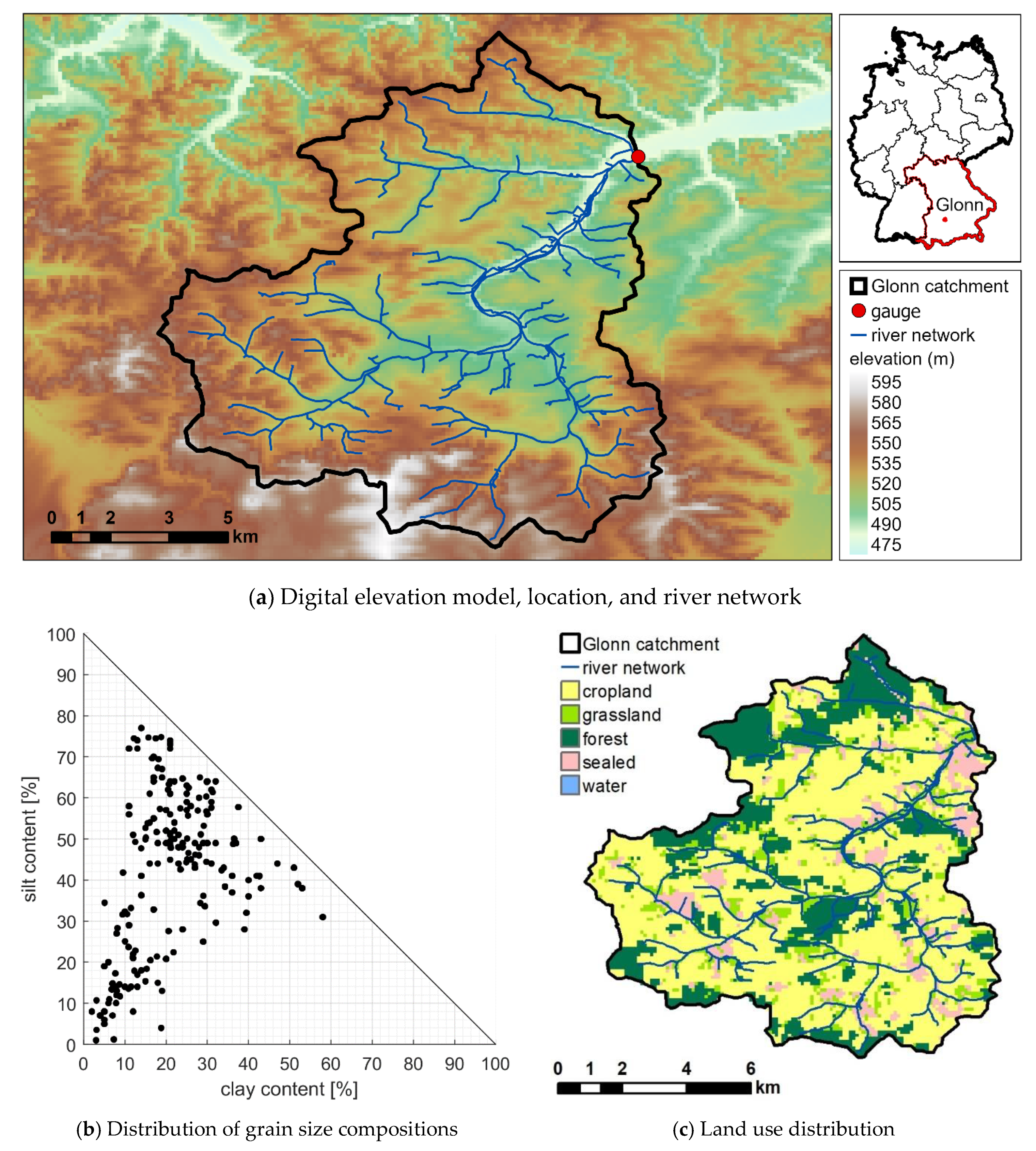
2.1. Study Area
2.2. Model Setup and Calibration
2.3. Scenario Definition
2.4. Evaluation Strategies
2.4.1. Soil Hydraulic Properties
2.4.2. Runoff Response
- %BiasRR: The percent bias in overall runoff ratio is a diagnostic signature index of the total water balance. It is expected to show primary sensitivity to model parameters that control evapotranspiration.
- %BiasMidslope: The percent bias of the mid-segment slope of the FDC (between 20% and 70% exceeding probability) indicates the reactivity of the catchment to the rainfall events and quantifies the rainfall-runoff response rate.
- %BiasFHV: The percent bias in high-segment volumes of the FDC (<2% exceeding probability) is related to the surface runoff and compares the peak discharges for heavy rainfall events.
- %BiasFLV: The percent bias in low-segment volumes of the FDC (>70% exceeding probability), that reflects the minimum discharge values and is related to the base flow.
2.4.3. Water Balance Components
2.4.4. Spatial Pattern Analysis
3. Results
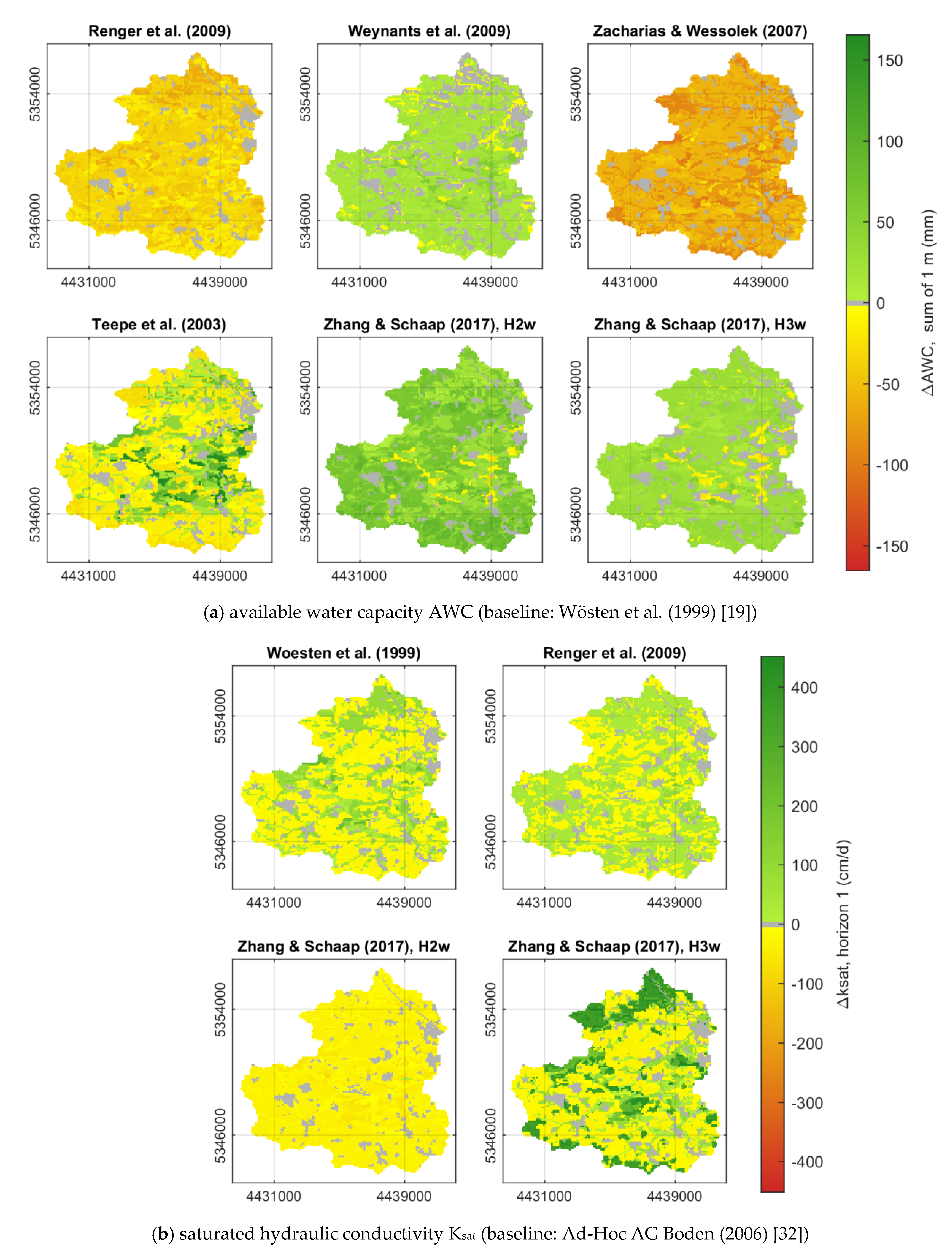
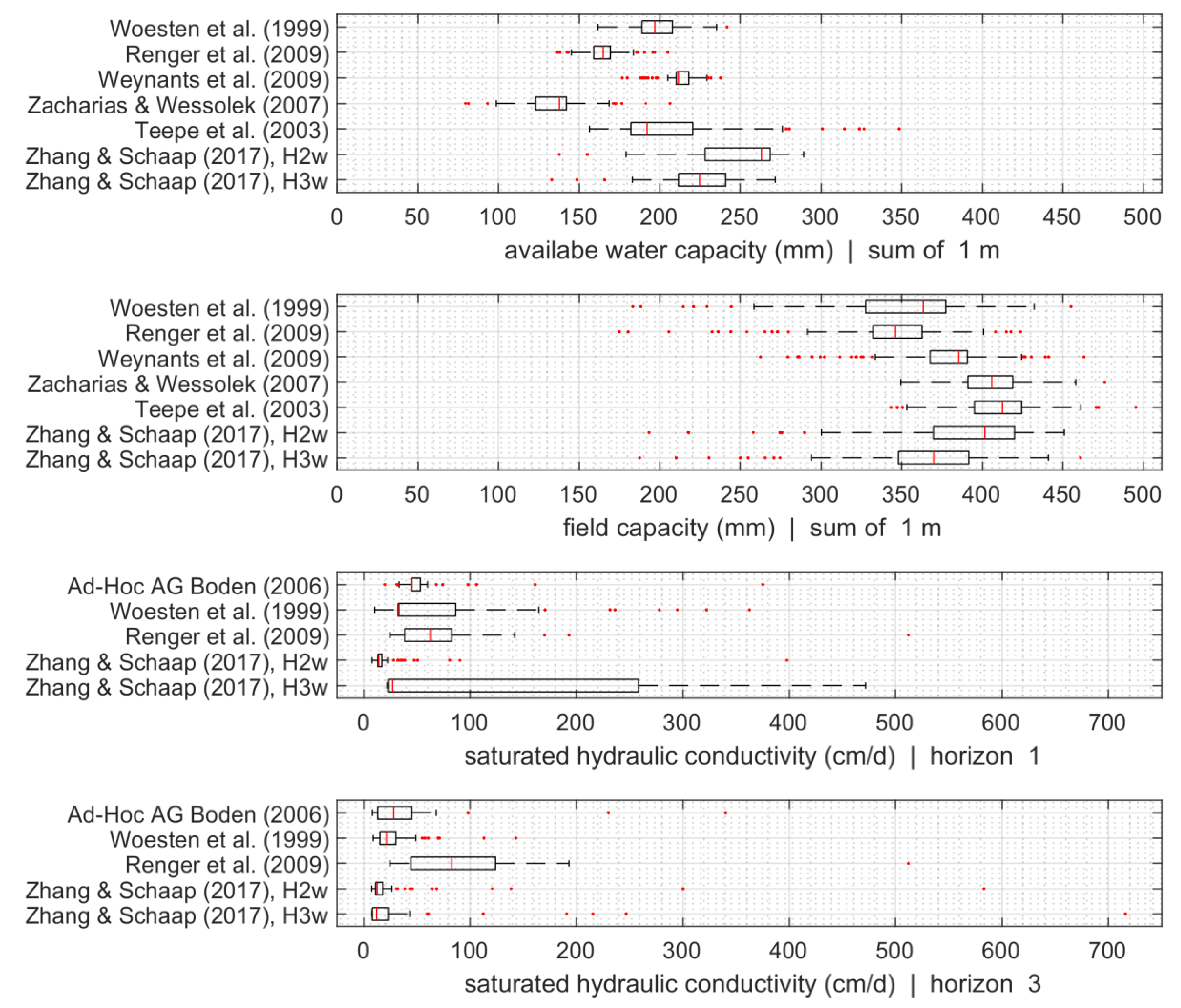
3.1. Soil Hydraulic Properties
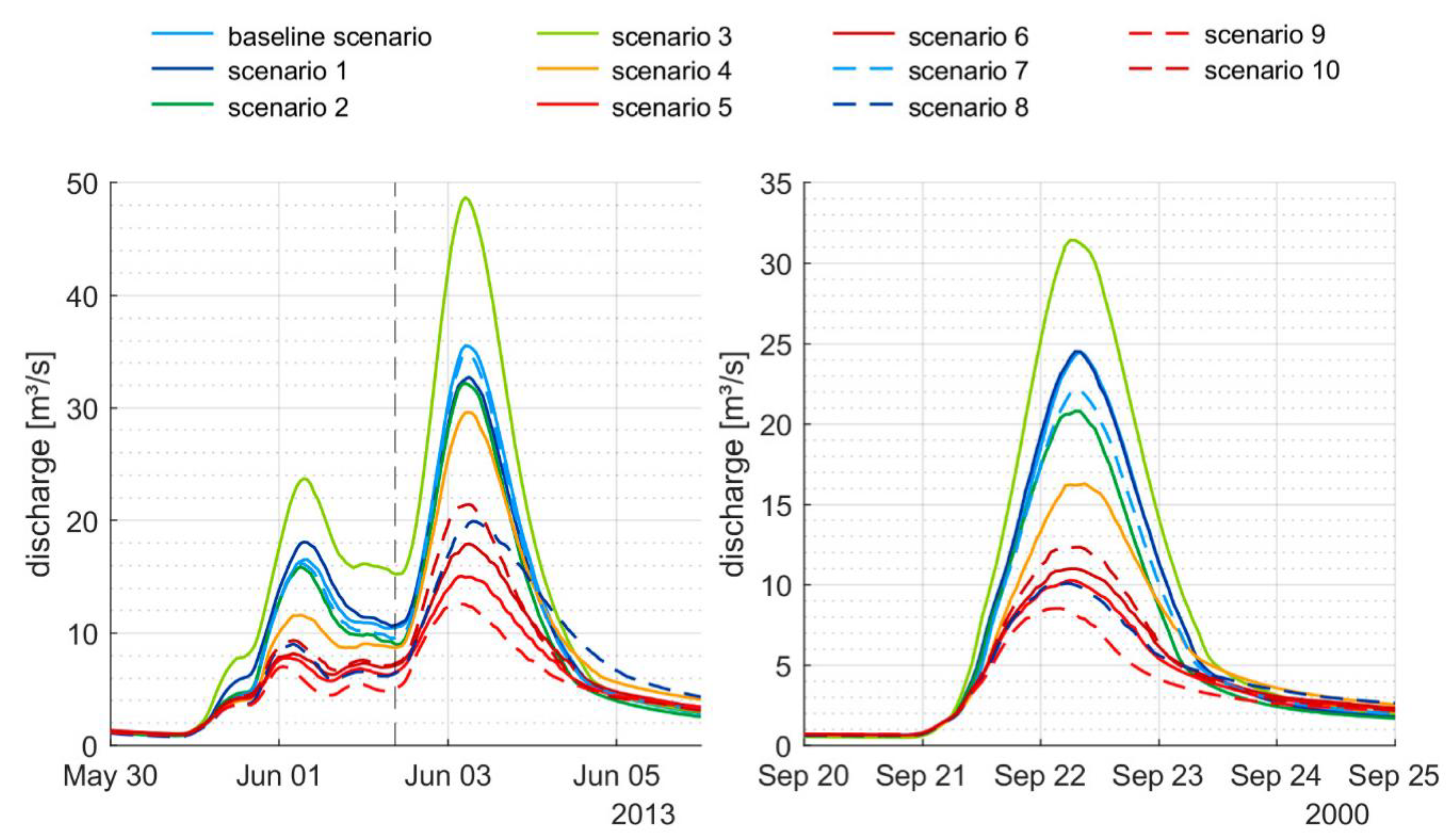
3.2. Runoff Response
3.3. Water Balance Components and Spatial Pattern Analysis
4. Discussion
5. Conclusions
Author Contributions
Funding
Institutional Review Board Statement
Informed Consent Statement
Data Availability Statement
Conflicts of Interest
References
- Gupta, H.V.; Beven, K.J.; Wagener, T. Model Calibration and Uncertainty Estimation. In Encyclopedia of Hydrological Sciences; John Wiley & Sons, Ltd.: Hoboken, NJ, USA, 2006. [Google Scholar] [CrossRef]
- Elsenbeer, H. Hydrologic Flowpaths in Tropical Rainforest Soilscapes—A Review. Hydrol. Process. 2001, 15, 1751–1759. [Google Scholar] [CrossRef]
- Montzka, C.; Herbst, M.; Weihermüller, L.; Verhoef, A.; Vereecken, H. A Global Data Set of Soil Hydraulic Properties and Sub-Grid Variability of Soil Water Retention and Hydraulic Conductivity Curves. Earth Syst. Sci. Data 2017, 9, 529–543. [Google Scholar] [CrossRef] [Green Version]
- Arnold, J.G.; Muttiah, R.S.; Srinivasan, R.; Allen, P.M. Regional Estimation of Base Flow and Groundwater Recharge in the Upper Mississippi River Basin. J. Hydrol. 2000, 227, 21–40. [Google Scholar] [CrossRef]
- Rieger, W.; Disse, M. Physikalisch Basierter Modellansatz Zur Beurteilung Der Wirksamkeit Einzelner Und Kombinierter Dezentraler Hochwasserschutzmaßnahmen. Hydrol. Wasserbewirtsch. 2013, 57, 14–25. [Google Scholar] [CrossRef]
- Richards, L.A. Capillary Conduction of Liquids through Porous Mediums. Physics 1931, 1, 318–333. [Google Scholar] [CrossRef]
- Ebel, B.A.; Loague, K. Physics-Based Hydrologic-Response Simulation: Seeing through the Fog of Equifinality. Hydrol. Process. Int. J. 2006, 20, 2887–2900. [Google Scholar] [CrossRef]
- Qu, Y.; Duffy, C.J. A Semidiscrete Finite Volume Formulation for Multiprocess Watershed Simulation. Water Resour. Res. 2007, 43, W08419. [Google Scholar] [CrossRef]
- Ivanov, V.Y.; Bras, R.L.; Vivoni, E.R. Vegetation-Hydrology Dynamics in Complex Terrain of Semiarid Areas: 1. A Mechanistic Approach to Modeling Dynamic Feedbacks. Water Resour. Res. 2008, 44, W03429. [Google Scholar] [CrossRef] [Green Version]
- Te Chow, V. Applied Hydrology; Tata McGraw-Hill Education: Pennsylvania Plaza, NY, USA, 2010. [Google Scholar]
- Wösten, J.; Pachepsky, Y.A.; Rawls, W. Pedotransfer Functions: Bridging the Gap between Available Basic Soil Data and Missing Soil Hydraulic Characteristics. J. Hydrol. 2001, 251, 123–150. [Google Scholar] [CrossRef]
- Bogena, H.; Herbst, M.; Huisman, J.; Rosenbaum, U.; Weuthen, A.; Vereecken, H. Potential of Wireless Sensor Networks for Measuring Soil Water Content Variability. Vadose Zone J. 2010, 9, 1002–1013. [Google Scholar] [CrossRef] [Green Version]
- Brooks, R.H.; Corey, A.T. Properties of Porous Media Affecting Fluid Flow. J. Irrig. Drain. Div. 1966, 92, 61–88. [Google Scholar] [CrossRef]
- Mualem, Y. A New Model for Predicting the Hydraulic Conductivity of Unsaturated Porous Media. Water Resour. Res. 1976, 12, 513–522. [Google Scholar] [CrossRef] [Green Version]
- Van Genuchten, M.T. A Closed-Form Equation for Predicting the Hydraulic Conductivity of Unsaturated Soils 1. Soil Sci. Soc. Am. J. 1980, 44, 892–898. [Google Scholar] [CrossRef] [Green Version]
- Aubertin, G.M.; Patric, J.H. Water Quality after Clearcutting a Small Watershed in West Virginia. J. Environ. Qual. 1974, 3, 243–249. [Google Scholar] [CrossRef] [Green Version]
- Vereecken, H.; Weynants, M.; Javaux, M.; Pachepsky, Y.; Schaap, M.; Van Genuchten, M.T. Using Pedotransfer Functions to Estimate the van Genuchten–Mualem Soil Hydraulic Properties: A Review. Vadose Zone J. 2010, 9, 795–820. [Google Scholar] [CrossRef]
- Bouma, J. Using Soil Survey Data for Quantitative Land Evaluation. In Advances in Soil Science; Springer: Berlin/Heidelberg, Germany, 1989; pp. 177–213. [Google Scholar]
- Wösten, J.; Lilly, A.; Nemes, A.; Le Bas, C. Development and Use of a Database of Hydraulic Properties of European Soils. Geoderma 1999, 90, 169–185. [Google Scholar] [CrossRef]
- Pachepsky, Y.; Rawls, W.J. Development of Pedotransfer Functions in Soil Hydrology; Elsevier: Amsterdam, The Netherlands, 2004; Volume 30, ISBN 978-0-444-51705-0. [Google Scholar]
- Patil, N.G.; Singh, S.K. Pedotransfer Functions for Estimating Soil Hydraulic Properties: A Review. Pedosphere 2016, 26, 417–430. [Google Scholar] [CrossRef]
- Schaap, M.G.; Leij, F.J. Using Neural Networks to Predict Soil Water Retention and Soil Hydraulic Conductivity. Soil Tillage Res. 1998, 47, 37–42. [Google Scholar] [CrossRef]
- Schaap, M.G.; Bouten, W. Modeling Water Retention Curves of Sandy Soils Using Neural Networks. Water Resour. Res. 1996, 32, 3033–3040. [Google Scholar] [CrossRef]
- Grayson, R.B.; Blöschl, G.; Western, A.W.; McMahon, T.A. Advances in the Use of Observed Spatial Patterns of Catchment Hydrological Response. Adv. Water Res. 2002, 25, 1313–1334. [Google Scholar] [CrossRef]
- Beven, K. Towards an Alternative Blueprint for a Physically Based Digitally Simulated Hydrologic Response Modelling System. Hydrol. Process. 2002, 16, 189–206. [Google Scholar] [CrossRef] [Green Version]
- Vereecken, H.; Diels, J.; Van Orshoven, J.; Feyen, J.; Bouma, J. Functional Evaluation of Pedotransfer Functions for the Estimation of Soil Hydraulic Properties. Soil Sci. Soc. Am. J. 1992, 56, 1371–1378. [Google Scholar] [CrossRef]
- Vereecken, H.; Maes, J.; Feyen, J.; Darius, P. Estimating the Soil Moisture Retention Characteristic from Texture, Bulk Density, and Carbon Content. Soil Sci. 1989, 148, 389–403. [Google Scholar] [CrossRef]
- Vereecken, H.; Maes, J.; Feyen, J. Estimating Unsaturated Hydraulic Conductivity from Easily Measured Soil Properties. Soil Sci. 1990, 149, 1–12. [Google Scholar] [CrossRef]
- Chirico, G.; Medina, H.; Romano, N. Functional Evaluation of PTF Prediction Uncertainty: An Application at Hillslope Scale. Geoderma 2010, 155, 193–202. [Google Scholar] [CrossRef]
- Seibert, J. Regionalisation of Parameters for a Conceptual Rainfall-Runoff Model. Agric. For. Meteorol. 1999, 98, 279–293. [Google Scholar] [CrossRef]
- Eckelmann, W.; Sponagel, H.; Grottenthaler, W.; Hartmann, K.-J.; Hartwich, R.; Janetzko, P.; Joisten, H.; Kühn, D.; Sabel, K.-J.; Traidl, R. Bayrisches Landesamt für Wasserwirtschaft: Fließgewässerlandschaften in Bayern; BAYERN|DIREKT: München, Germany, 2002. [Google Scholar]
- Ad-hoc-AG Boden Bodenkundliche Kartieranleitung, 5th ed.; Schweizerbart Science Publishers: Stuttgart, Germany, 2006; ISBN 978-3-510-95920-4.
- Schulla, J. Model Description WaSiM (Water Balance Simulation Model); Hydrology Software Consulting: Zürich, Switzerland, 2019; p. 379. [Google Scholar]
- Moriasi, D.N.; Arnold, J.G.; Van Liew, M.W.; Bingner, R.L.; Harmel, R.D.; Veith, T.L. Model Evaluation Guidelines for Systematic Quantification of Accuracy in Watershed Simulations. Trans. ASABE 2007, 50, 885–900. [Google Scholar] [CrossRef]
- Renger, M.; Bohne, K.; Facklam, M.; Harrach, T.; Riek, W.; Schäfer, W.; Wessolek, G.; Zacharias, S. Ergebnisse Und Vorschläge Der DBG-Arbeitsgruppe “Kennwerte Des Bodengefüges” Zur Schätzung Bodenphysikalischer Kennwerte. Acad. Accel. World’s Res. 2008, 40, 4–51. [Google Scholar]
- Weynants, M.; Vereecken, H.; Javaux, M. Revisiting Vereecken Pedotransfer Functions: Introducing a Closed-Form Hydraulic Model. Vadose Zone J. 2009, 8, 86–95. [Google Scholar] [CrossRef] [Green Version]
- Zacharias, S.; Wessolek, G. Excluding Organic Matter Content from Pedotransfer Predictors of Soil Water Retention. Soil Sci. Soc. Am. J. 2007, 71, 43–50. [Google Scholar] [CrossRef]
- Teepe, R.; Dilling, H.; Beese, F. Estimating Water Retention Curves of Forest Soils from Soil Texture and Bulk Density. J. Plant Nutr. Soil Sci. 2003, 166, 111–119. [Google Scholar] [CrossRef]
- Zhang, Y.; Schaap, M.G. Weighted Recalibration of the Rosetta Pedotransfer Model with Improved Estimates of Hydraulic Parameter Distributions and Summary Statistics (Rosetta3). J. Hydrol. 2017, 547, 39–53. [Google Scholar] [CrossRef] [Green Version]
- Tóth, B.; Weynants, M.; Pásztor, L.; Hengl, T. 3D Soil Hydraulic Database of Europe at 250 m Resolution. Hydrol. Process. 2017, 31, 2662–2666. [Google Scholar] [CrossRef] [Green Version]
- Rajkai, K.; Kabos, S.; Van Genuchten, M.T. Estimating the Water Retention Curve from Soil Properties: Comparison of Linear, Nonlinear and Concomitant Variable Methods. Soil Tillage Res. 2004, 79, 145–152. [Google Scholar] [CrossRef]
- Wessolek, G.; Duijnisveld, W.; Trinks, S. Hydro-Pedotransfer Functions (HPTFs) for Predicting Annual Percolation Rate on a Regional Scale. J. Hydrol. 2008, 356, 17–27. [Google Scholar] [CrossRef]
- Nemes, A.; Schaap, M.; Leij, F.; Wösten, J. Description of the Unsaturated Soil Hydraulic Database UNSODA Version 2.0. J. Hydrol. 2001, 251, 151–162. [Google Scholar] [CrossRef]
- Tempel, P.; Batjes, N.; Van Engelen, V. IGBP-DIS Soil Data Set for Pedotransfer Function Development. ISRIC 1996, 447365. [Google Scholar]
- Schaap, M.G.; Leij, F.J.; Van Genuchten, M.T. Rosetta: A Computer Program for Estimating Soil Hydraulic Parameters with Hierarchical Pedotransfer Functions. J. Hydrol. 2001, 251, 163–176. [Google Scholar] [CrossRef]
- Vogel, R.M.; Fennessey, N.M. Flow-Duration Curves. I: New Interpretation and Confidence Intervals. J. Water Res. Plan. Manag. 1994, 120, 485–504. [Google Scholar] [CrossRef]
- Smakhtin, V.U. Low Flow Hydrology: A Review. J. Hydrol. 2001, 240, 147–186. [Google Scholar] [CrossRef]
- Yilmaz, K.K.; Gupta, H.V.; Wagener, T. A Process-Based Diagnostic Approach to Model Evaluation: Application to the NWS Distributed Hydrologic Model. Water Resour. Res. 2008, 44, W09417. [Google Scholar] [CrossRef] [Green Version]
- Casper, M.C.; Grigoryan, G.; Gronz, O.; Gutjahr, O.; Heinemann, G.; Ley, R.; Rock, A. Analysis of Projected Hydrological Behavior of Catchments Based on Signature Indices. Hydrol. Earth Syst. Sci. 2012, 16, 409–421. [Google Scholar] [CrossRef] [Green Version]
- Swain, M.J.; Ballard, D.H. Color Indexing. Int. J. Comput. Vis. 1991, 7, 11–32. [Google Scholar] [CrossRef]
- Demirel, M.C.; Mai, J.; Mendiguren, G.; Koch, J.; Samaniego, L.; Stisen, S. Combining Satellite Data and Appropriate Objective Functions for Improved Spatial Pattern Performance of a Distributed Hydrologic Model. Hydrol. Earth Syst. Sci. 2018, 22, 1299–1315. [Google Scholar] [CrossRef] [Green Version]
- Wang, J.-P.; Hu, N.; François, B.; Lambert, P. Estimating Water Retention Curves and Strength Properties of Unsaturated Sandy Soils from Basic Soil Gradation Parameters. Water Resour. Res. 2017, 53, 6069–6088. [Google Scholar] [CrossRef]
- Zheng, J.; Shao, M.; Zhang, X. Spatial Variation of Surface Soil’s Bulk Density and Saturated Hydraulic Conductivity on Slope in Loess Region. J. Soil Water Conserv. 2004, 18, 53–56. [Google Scholar] [CrossRef]
- Nemes, A.; Rawls, W.J.; Pachepsky, Y.A. Influence of Organic Matter on the Estimation of Saturated Hydraulic Conductivity. Soil Sci. Soc. Am. J. 2005, 69, 1330–1337. [Google Scholar] [CrossRef]
- Azuka, C.; Igué, A. Surface Runoff as Influenced by Slope Position and Land Use in the Koupendri Catchment of Northwest Benin: Field Observation and Model Validation. Hydrol. Sci. J. 2020, 65, 995–1004. [Google Scholar] [CrossRef]
- Dobarco, M.R.; Bourennane, H.; Arrouays, D.; Saby, N.P.; Cousin, I.; Martin, M.P. Uncertainty Assessment of GlobalSoilMap Soil Available Water Capacity Products: A French Case Study. Geoderma 2019, 344, 14–30. [Google Scholar] [CrossRef]
- Li, X.; Shao, M.; Zhao, C.; Jia, X. Spatial Variability of Soil Water Content and Related Factors across the Hexi Corridor of China. J. Arid Land 2019, 11, 123–134. [Google Scholar] [CrossRef] [Green Version]
- Casper, M.C.; Mohajerani, H.; Hassler, S.K.; Herdel, T.; Blume, T. Finding Behavioral Parameterization for a 1-D Water Balance Model by Multi-Criteria Evaluation. J. Hydrol. Hydromech. 2019, 67, 213–224. [Google Scholar] [CrossRef] [Green Version]
- Rajib, A.; Evenson, G.R.; Golden, H.E.; Lane, C.R. Hydrologic Model Predictability Improves with Spatially Explicit Calibration Using Remotely Sensed Evapotranspiration and Biophysical Parameters. J. Hydrol. 2018, 567, 668–683. [Google Scholar] [CrossRef] [PubMed]
- Kirchner, J.W. Getting the Right Answers for the Right Reasons: Linking Measurements, Analyses, and Models to Advance the Science of Hydrology. Water Resour. Res. 2006, 42. [Google Scholar] [CrossRef]
- Nasta, P.; Boaga, J.; Deiana, R.; Cassiani, G.; Romano, N. Comparing ERT-and Scaling-Based Approaches to Parameterize Soil Hydraulic Properties for Spatially Distributed Model Applications. Adv. Water Res. 2019, 126, 155–167. [Google Scholar] [CrossRef]
- Herbst, M.; Diekkrüger, B. The Influence of the Spatial Structure of Soil Properties on Water Balance Modeling in a Microscale Catchment. Phys. Chem. Earth Parts A/B/C 2002, 27, 701–710. [Google Scholar] [CrossRef]
- Bayabil, H.K.; Dile, Y.T.; Tebebu, T.Y.; Engda, T.A.; Steenhuis, T.S. Evaluating Infiltration Models and Pedotransfer Functions: Implications for Hydrologic Modeling. Geoderma 2019, 338, 159–169. [Google Scholar] [CrossRef]
- Li, Y.; Chen, D.; White, R.E.; Zhu, A.; Zhang, J. Estimating Soil Hydraulic Properties of Fengqiu County Soils in the North China Plain Using Pedo-Transfer Functions. Geoderma 2007, 138, 261–271. [Google Scholar] [CrossRef]
- Casper, M.C.; Vohland, M. Validation of a Large Scale Hydrological Model with Data Fields Retrieved from Reflective and Thermal Optical Remote Sensing Data—A Case Study for the Upper Rhine Valley. Phys. Chem. Earth Parts A/B/C 2008, 33, 1061–1067. [Google Scholar] [CrossRef]


| Parameter | Description |
|---|---|
| Horizon | ID for each soil horizon; one value per horizon. |
| Layer | Number of numerical layers for each horizon. |
| Thickness | Thickness of each single numerical layer in this horizon in m; one value per horizon. |
| Ksat | Saturated hydraulic conductivity in m/s; one value per soil horizon. |
| Θsat | Saturated water content (fillable porosity in 1/1); one value per soil horizon. |
| Θres | Residual water content (in 1/1, water content which cannot be extracted by transpiration, only by evaporation); one value per soil horizon. |
| α | van Genuchten Parameter α; one value per soil horizon. |
| n | van Genuchten Parameter n; one value per soil horizon. |
| Krecession | Ksat recession with depth: factor of recession per meter (only applied for the uppermost 2 m of the soil); one value per horizon. |
| Parameter | Calibration | Validation |
|---|---|---|
| Time period | 1 November 1995–31 October 2004 | 1 November 2004–31 October 2013 |
| NSE | 0.74 | 0.65 |
| NSElog | 0.61 | 0.67 |
| PBIAS | 13.2 | −1.9 |
| Volume share of | ||
| Baseflow | 0.16 | 0.14 |
| Interflow | 0.14 | 0.14 |
| Surface runoff | 0.04 | 0.05 |
| Evapotranspiration | 0.68 | 0.67 |
| Scenario | Van Genuchten Parameter | Saturated Hydraulic Conductivity |
|---|---|---|
| Baseline | Wösten et al. (1999) [19] | Ad-Hoc AG Boden (2006) [32] |
| 1 | Renger et al. (2009) [35] | Ad-Hoc AG Boden (2006) [32] |
| 2 | Weynants et al. (2009) [36] | Ad-Hoc AG Boden (2006) [32] |
| 3 | Zacharias & Wessolek (2007) [37] | Ad-Hoc AG Boden (2006) [32] |
| 4 | Teepe et al. (2003) [38] | Ad-Hoc AG Boden (2006) [32] |
| 5 | Zhang & Schaap (2017): Rosetta H2w [39] | Ad-Hoc AG Boden (2006) [32] |
| 6 | Zhang & Schaap (2017): Rosetta H3w [39] | Ad-Hoc AG Boden (2006) [32] |
| 7 | Wösten et al. (1999) [19] | Wösten et al. (1999) [19] |
| 8 | Renger et al. (2009) [35] | Renger et al. (2009) [35] |
| 9 | Zhang & Schaap (2017): Rosetta H2w [39] | Zhang & Schaap (2017): Rosetta H2w [39] |
| 10 | Zhang & Schaap (2017): Rosetta H3w [39] | Zhang & Schaap (2017): Rosetta H3w [39] |
| PTF | Method | Database | Sample Size | Predictors |
|---|---|---|---|---|
| Wösten et al. (1999) [19] | Regression analysis | HYPRES [19] | 5521 | Clay, Silt, OM, BD, topsoil/subsoil |
| Renger et al. (2009) [35] | Regression analysis | various sources | unknown | Sand, Silt, Clay |
| Weynants et al. (2009) [36] | Regression analysis | Vereecken et al., 1989 [27] | 166 | Sand, Silt, Clay, BD, OM |
| Zacharias and Wessolek (2007) [37] | Regression analysis | IGBP-DIS soil data (Tempel et al., 1996) [44]; UNSODA (Nemes et al., 2001) [43] | 676 | Sand, Silt, Clay, BD |
| Teepe et al. (2003) [38] | Regression analysis | Teepe et al. (2003) [38] | 1850 | Lookup table: Sand, Silt, Clay, BD |
| Zhang & Schaap (2017), Rosetta H2w [39] | Single Artificial Neural Network | Schaap et al. (2001) [45] | 2134 for WRC, 1306 for Ksat | Sand, Silt, Clay |
| Zhang & Schaap (2017), Rosetta H3w [39] | Single Artificial Neural Network | Schaap et al. (2001) [45] | 2134 for WRC, 1306 for Ksat | Sand, Silt, Clay, BD |
| Scenario | Peak Change (%) | Volume Change (%) | ||||||
|---|---|---|---|---|---|---|---|---|
| 06/2013 (1) | 06/2013 (2) | 09/2000 | 06/2013 (1) | 06/2013 (2) | 09/2000 | calib. | valid. | |
| 1 | 9.4 | −7.9 | 0.0 | 10.0 | −4.6 | 1.0 | −4.7 | −0.5 |
| 2 | −3.8 | −9.4 | −15.1 | −5.4 | −11.1 | −13.0 | −5.2 | −4.5 |
| 3 | 43.4 | 37.0 | 28.3 | 44.1 | 29.2 | 26.8 | −6.7 | −4.7 |
| 4 | −29.8 | −16.7 | −33.6 | −20.7 | −8.0 | −18.9 | −5.7 | −4.6 |
| 5 | −52.9 | −57.6 | −58.0 | −39.9 | −42.6 | −41.1 | −0.6 | −0.7 |
| 6 | −50.5 | −49.5 | −55.1 | −36.2 | −34.6 | −36.9 | −0.9 | −0.6 |
| 7 | −2.2 | −1.9 | −9.5 | −3.6 | −2.7 | −6.6 | 0.0 | 0.4 |
| 8 | −45.3 | −43.9 | −58.8 | −39.5 | −21.7 | −39.3 | −2.4 | 0.3 |
| 9 | −57.4 | −64.6 | −65.2 | −49.8 | −50.1 | −50.4 | −0.6 | −0.8 |
| 10 | −43.3 | −39.7 | −49.6 | −32.3 | −30.4 | −34.3 | −1.9 | −1.6 |
| Scenario | %BiasRR | %BiasMidslope | %BiasFHV | %BiasFLV |
|---|---|---|---|---|
| 1 | −2.6 | 7.5 | 10.1 | −16.8 |
| 2 | −4.8 | 1.0 | −3.9 | −11.2 |
| 3 | −5.7 | 87.5 | 43.5 | −47.2 |
| 4 | −5.1 | 43.3 | −11.8 | −25.4 |
| 5 | −0.6 | 20.2 | −24.6 | −11.1 |
| 6 | −0.7 | 38.1 | −20.8 | −25.7 |
| 7 | 0.2 | 1.0 | −2.5 | −0.3 |
| 8 | −1.0 | −0.1 | −23.5 | 6.1 |
| 9 | −0.7 | −3.6 | −34.7 | 14.1 |
| 10 | −1.7 | 27.1 | −18.0 | −21.3 |
| Water Balance Components (mm/a) | Infiltration Components (mm/a) | ||||||||||||||
|---|---|---|---|---|---|---|---|---|---|---|---|---|---|---|---|
| Surface Runoff | Interflow | Base Flow | Transpiration | Evaporation | Snow Evaporation | Interception Evaporation | Change in Soil Storage | Change in Snow Storage | Infiltration Excess | Macropore infiltration | Matrix Infiltration | Interception Evaporation | Snow Evaporation | ||
| Baseline | 39 | 117 | 121 | 99 | 302 | 14 | 163 | 4 | 0 | 39 | 19 | 625 | 163 | 14 | |
| Scenario | 1 | 42 | 121 | 108 | 98 | 303 | 14 | 163 | 10 | 0 | 42 | 19 | 622 | 163 | 14 |
| 2 | 41 | 113 | 110 | 99 | 316 | 14 | 163 | 4 | 0 | 41 | 19 | 624 | 163 | 14 | |
| 3 | 50 | 117 | 95 | 99 | 323 | 14 | 163 | 0 | 0 | 50 | 18 | 615 | 163 | 14 | |
| 4 | 37 | 89 | 136 | 99 | 322 | 14 | 163 | 0 | 0 | 37 | 19 | 627 | 163 | 14 | |
| 5 | 34 | 120 | 122 | 97 | 310 | 14 | 163 | 0 | 0 | 34 | 19 | 630 | 163 | 14 | |
| 6 | 34 | 135 | 106 | 97 | 310 | 14 | 163 | 0 | 0 | 34 | 19 | 630 | 163 | 14 | |
| 7 | 39 | 121 | 119 | 99 | 302 | 14 | 163 | 4 | 0 | 39 | 19 | 625 | 163 | 14 | |
| 8 | 36 | 123 | 117 | 99 | 299 | 14 | 163 | 10 | 0 | 36 | 19 | 628 | 163 | 14 | |
| 9 | 35 | 107 | 133 | 97 | 309 | 14 | 163 | 1 | 0 | 35 | 19 | 629 | 163 | 14 | |
| 10 | 35 | 133 | 108 | 97 | 311 | 14 | 163 | 0 | 0 | 35 | 19 | 629 | 163 | 14 | |
| Scenario | Correl | Histo | Correl | Histo | Correl | Histo | Correl | Histo |
|---|---|---|---|---|---|---|---|---|
| Direct Runoff | Interflow | Baseflow | ETa | |||||
| 1 | 0.997 | 0.804 | 0.942 | 0.893 | 0.996 | 0.985 | 0.997 | 0.819 |
| 2 | 0.999 | 0.697 | 0.975 | 0.892 | 0.998 | 0.976 | 0.998 | 0.727 |
| 3 | 0.992 | 0.423 | 0.782 | 0.769 | 0.978 | 0.970 | 0.988 | 0.349 |
| 4 | 0.997 | 0.786 | 0.500 | 0.381 | 0.976 | 0.987 | 0.997 | 0.744 |
| 5 | 0.997 | 0.653 | 0.835 | 0.829 | 0.990 | 0.966 | 0.996 | 0.652 |
| 6 | 0.995 | 0.473 | 0.916 | 0.874 | 0.995 | 0.965 | 0.998 | 0.653 |
| 7 | 0.999 | 0.683 | 0.962 | 0.898 | 0.999 | 0.994 | 1.000 | 0.827 |
| 8 | 0.997 | 0.758 | 0.913 | 0.910 | 0.997 | 0.988 | 0.997 | 0.846 |
| 9 | 0.997 | 0.712 | 0.795 | 0.746 | 0.990 | 0.975 | 0.995 | 0.626 |
| 10 | 0.996 | 0.782 | 0.900 | 0.909 | 0.994 | 0.965 | 0.997 | 0.618 |
Publisher’s Note: MDPI stays neutral with regard to jurisdictional claims in published maps and institutional affiliations. |
© 2021 by the authors. Licensee MDPI, Basel, Switzerland. This article is an open access article distributed under the terms and conditions of the Creative Commons Attribution (CC BY) license (https://creativecommons.org/licenses/by/4.0/).
Share and Cite
Mohajerani, H.; Teschemacher, S.; Casper, M.C. A Comparative Investigation of Various Pedotransfer Functions and Their Impact on Hydrological Simulations. Water 2021, 13, 1401. https://doi.org/10.3390/w13101401
Mohajerani H, Teschemacher S, Casper MC. A Comparative Investigation of Various Pedotransfer Functions and Their Impact on Hydrological Simulations. Water. 2021; 13(10):1401. https://doi.org/10.3390/w13101401
Chicago/Turabian StyleMohajerani, Hadis, Sonja Teschemacher, and Markus C. Casper. 2021. "A Comparative Investigation of Various Pedotransfer Functions and Their Impact on Hydrological Simulations" Water 13, no. 10: 1401. https://doi.org/10.3390/w13101401
APA StyleMohajerani, H., Teschemacher, S., & Casper, M. C. (2021). A Comparative Investigation of Various Pedotransfer Functions and Their Impact on Hydrological Simulations. Water, 13(10), 1401. https://doi.org/10.3390/w13101401