1. Introduction
In the Middle East, most of the river flow originates outside the countries, and transboundary waters represent over two-thirds of the overall region water resources [
1,
2]. In a transboundary basin, no riparian state can independently dispose of its water, and all countries are compelled to consider each other’s water rights and demands. Under grave shortage of water resources and uncertainty of regular water supply, such situation inevitably causes tension and discord in riparian water relations. It also implies the need for agreements and cooperation on water issues despite seemingly insurmountable geopolitical, socio-economic, and management problems and the negative historical experience of such efforts. It is evident that absence of the complete picture of water-related dynamics in transboundary basins and the lack of a basin-wide vision over the shared waters may result in disputes among the riparian states and ultimately in an unsustainable and biased use of the resources. There is no doubt on the importance and need of reliable data for making water-use decisions, but unfortunately reality is different. The following examples (randomly selected from many similar ones) illustrate the real situation: “The absence of official data (from Syria) on the amount of water diverted from the Yarmouk has left much room for speculation over the years” [
1], or “The water balance scheme in the Jordan River Basin is based on the available data to date, which were provided from the different sources and not believed to be so accurate or highly consistent” [
3], etc.
Such situations are due to strained international relations between the riparian states in the transboundary basin caused by internal economic, political, and national interests. All this may result in secrecy and even distortion of the data on water use [
4,
5,
6,
7]. However, in many known cases (see below in the present paper), the situation was aggravated not only and not so much by the availability (or secrecy) of data but because of the real lack or absence of data. Both of these circumstances determine and confirm the relevance of the proposed study topic which is assessing water withdrawals in the transboundary basin by using alternative data on precipitation and river flow.
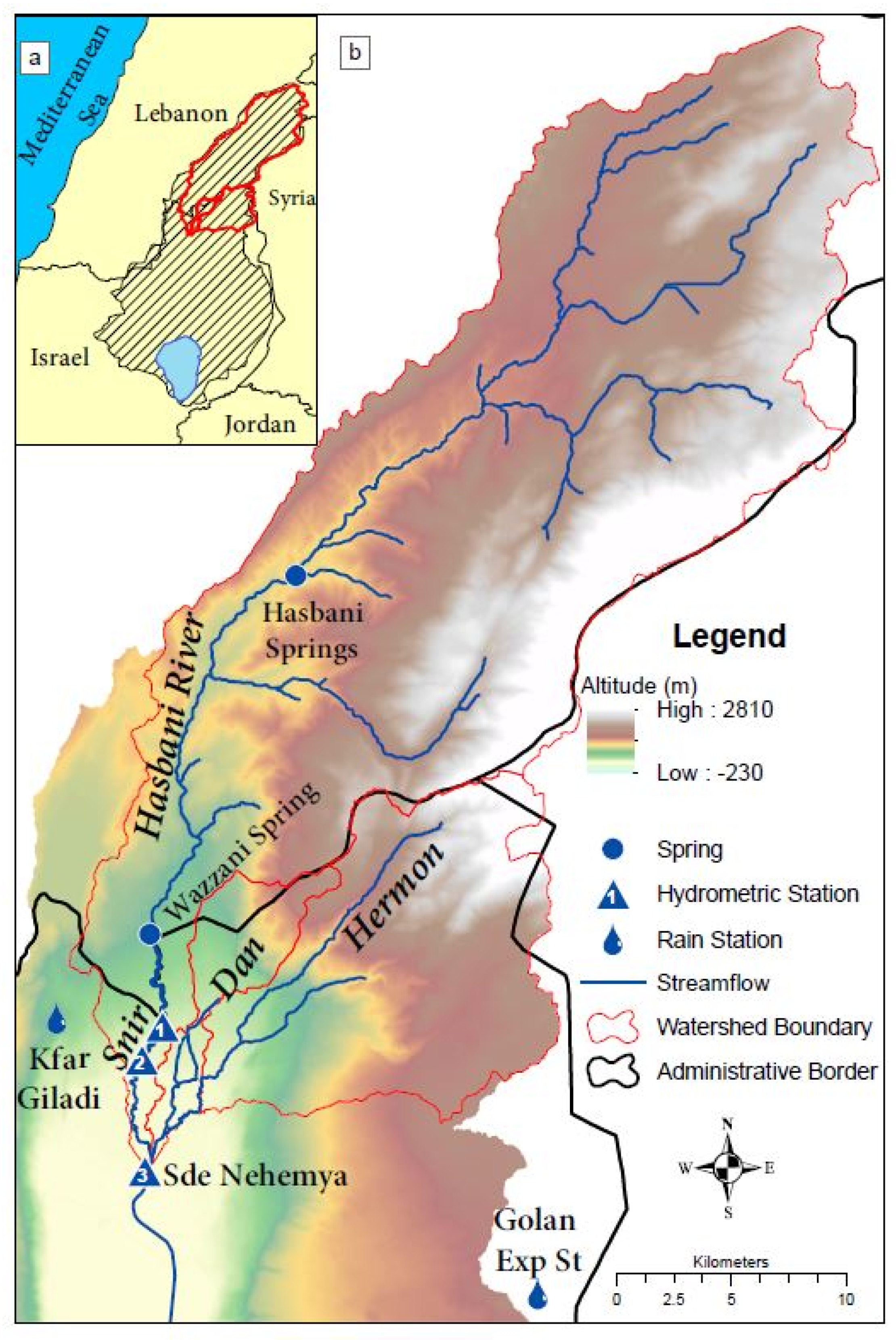
The studied Hasbani River (named Snir in Israel) is one of the major tributaries of the Upper Jordan River (UJR) which contributes more than a quarter of the total inflow to it (
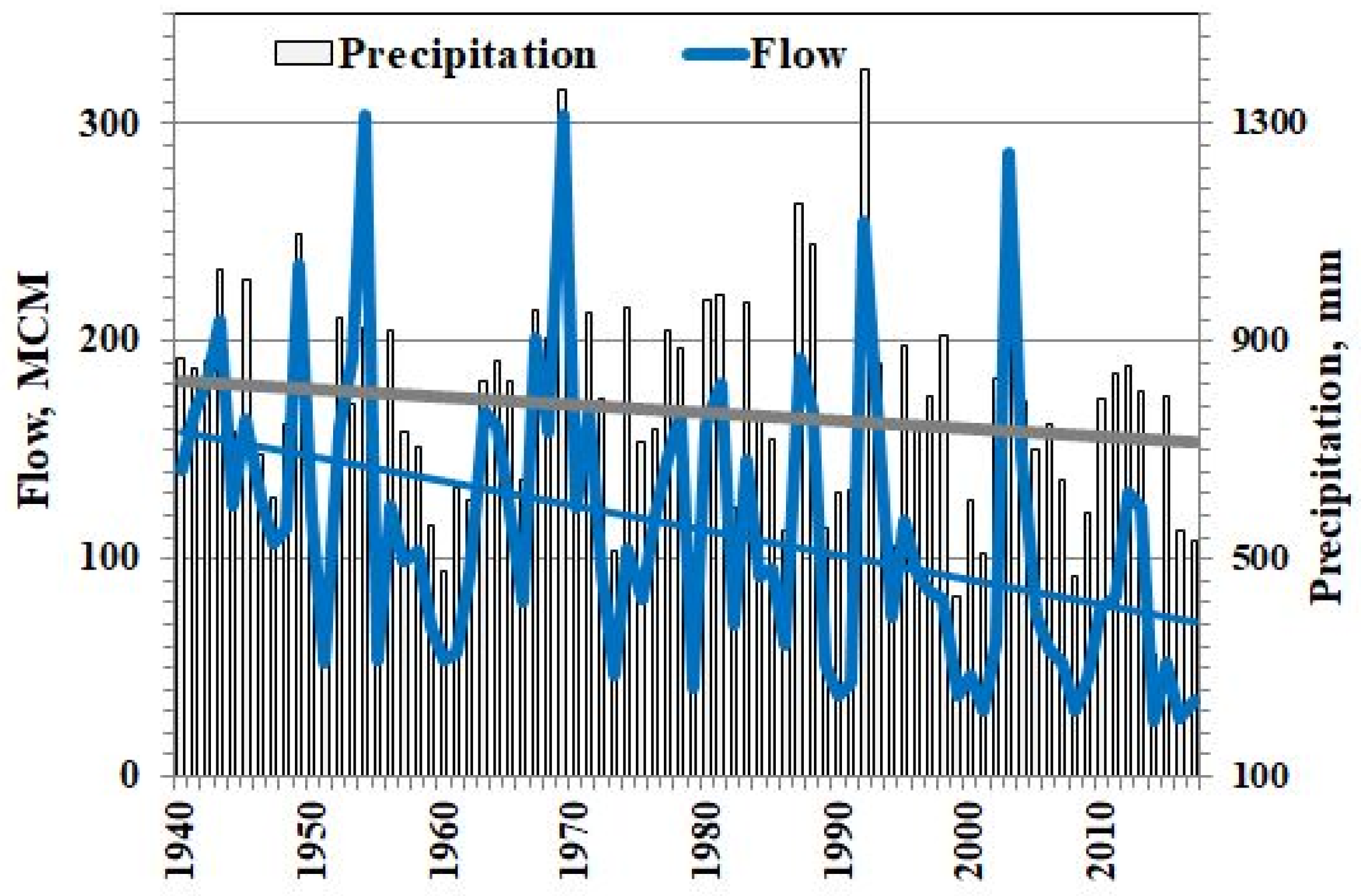
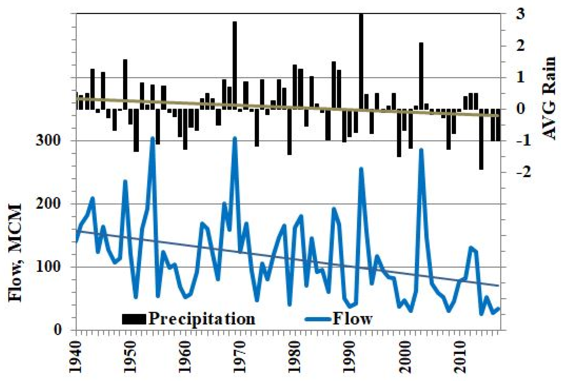
Figure 1). The catchment area of the transboundary Hasbani basin is shared between Lebanon and Israel at respective rates of 97% and 3%. Hence, most of the flow formation and water use occur in the Lebanese part of the basin. The present study revealed significant decrease (about 50%) of the Hasbani River annual flow during 1940–2017 and only 13–15% decrease of the annual precipitation gauged in this period at the representative stations. Such significant flow decline of the Hasbani River cannot be caused only by the precipitation decrease but seems to be also the result of the developing water use.
A drastic decrease in the flow of rivers in Lebanon has been recorded during the last three decades [
8]. Decreases of spring and stream flow were documented both in the Jordan River basin [
9,
10,
11], as well as in the Litani basin in Lebanon [
12]. Data on available water (AW) in Lake Kinneret (1975–2007) indicated a decreasing trend which was concurrent with the decreasing trend in precipitation and the increasing water use in the entire Lake watershed. According to the Israeli Water Authority, the increasing water use explains at least three quarters of the total decrease in the AW during this period [
10,
13]. Concurrently, statistical analyses of rainfall time series in Israel have not detected significant decrease in rainfall trends [
14,
15].
There is no major disagreement that both climate change and increasing human activity impact the water balance of the Jordan River headwaters and of the entire Lake Kinneret Basin. However, the relative contribution of each factor remains to be debated especially considering the unspecified Lebanese water use from the Hasbani River [
9,
13,
16,
17,
18,
19]. The published values of the Hasbani water use by Lebanon are rather uncertain and insignificant (see
Section 6.1 below). The question remains open whether these estimated values are sufficient to explain the significant decrease in the flow of the Hasbani River (1940–2017), even taking into account the observed decrease in precipitation.
Due to insufficient data on water use in the Hasbani River basin, it is evident that (i) any clarification and updating of these data would be an essential contribution to assessing the water balance in the UJR basin, and (ii) the problem requires an alternative approach and a nonstandard solution allowing to differentiate climate and human impacts on the river flow regime. For this purpose the present study applies the method proposed by the authors [
20] for assessing water consumption in a transboundary basin under conditions of scarce available data on water use. The method is based on analyzing the alternative data on precipitation and river flow and was efficiently applied to the Yarmouk River (1971–2009) up to the Maqaren Station (Syrian part of the basin). In the present paper, the method was conceptually revised taking into consideration the outcomes of recent widespread discussions of the difference between “water consumption” and “water supply” (use, withdrawal, abstraction). By definitions of the USGS Glossary [
21], the object of this study is accepted as assessing water withdrawals, but not water consumption (as in the previous publication [
20]). The title of the present article has been updated accordingly. Nevertheless, the calculation technique remained unchanged. Therefore, withdrawals are estimated as the total amount of water removed from the source (or did not reach the downstream hydrometric station and not included in the gauged flow), regardless of how much of that total is consumptively (or non-consumptively) used [
22]. The designation AWW (assessing water withdrawals) of the method is hereinafter used.
Assessing the impact of water use on water resources is one of the urgent problems of modern hydrology. The publications offer a huge number of approaches, methods, and models for its solution in general and for particular cases. These studies apply nonparametric methods to analyze the changing point and annual trend in various hydro-meteorological time series (e.g., rainfall, temperature, flow and groundwater levels), and afterwards, they employ an integrated model of surface-groundwater flow to simulate effects of alternative water-use scenarios on groundwater levels and streamflow. The differences are in kind and scale of the model, research goal, and results. Some typical examples of similar studies are presented in
Appendix A.
In contrast to the modeling flow with consideration of water use as an influencing driver (in the studies presented above), the AWW method offers an inverse solution to the problem. The latter assesses water withdrawal using data on the basin input and output (measured precipitation and flow) within the simple statistical model. This is the novelty of the method and its specificity.
The main objective of the present study can be formulated as (i) Assessing water withdrawals from the Hasbani river flow (Lebanon) by the AWW method; (ii) validation of the AWW method and confirmation of reliability of the obtained results.
The paper is built as following:
Section 2 presents a brief description of the study area;
Section 3 presents the available data and introduces the AWW method which is adopted for the case study in
Section 4;
Section 5 presents a wide range of results such as estimated withdrawals from the Hasbani River for the study period, validation of the AWW method, confirmation of estimates by indirect indices, and estimated withdrawals from surface and base flow; in
Section 6 results obtained are discussed; conclusions and recommendations are provided in
Section 7.
It is important to emphasize that the use of the Hasbani river flow in Lebanon has been for decades a source of tension and of discord between Lebanon and Israel. To the present day there is no agreement on the use of these transboundary waters. The proposed study focuses on hydrological aspects of the problem (specifically, on assessing water withdrawals from the Hasbani River by alternative hydrometric and precipitation data), disregarding geopolitical, socio-economic, and management issues, and without touching upon the issue of transboundary water relations and disagreement between both riparian countries.
2. Study Area
The Hasbani (Snir) River is one of the major tributaries of the Upper Jordan River (UJR) (
Figure 1). It is a significant flow source, which contributes 26% of the total inflow to UJR while the remaining flow is formed by the Dan and Hermon Rivers [
10,
16,
17]. In the present study, contribution of the Hasbani River updated to 30%.
The main sources of the Jordan River are located in the southern foothills of the Hermon Range, which is an elongated anticline, mostly built of >2000 m Jurassic karstic limestone. The Mt. Hermon range is 55 km long and 25 km wide. Its high regions (above 1000 m a.s.l., the summit 2814 m a.s.l.) receive the highest annual precipitation (>1400 mm/year).
The Hasbani River originates from the Hasbani springs (outflowing from karst in the northern part of the basin), flows southwards for about 20 km until reaching the point at which its flow is substantially increased by the Wazzani spring. About 0.5 km downstream the river reaches the Lebanese–Israeli border, flows for about 4 km along the border, and after 7 km joins with Hermon (Banias) and Dan Rivers in northern Israel near Sede Nehemya (Yosef Bridge), to form the Upper Jordan River. The surface catchment area of the transboundary Hasbani basin (614 sq. km) is shared between Lebanon and Israel as 97% and 3%, respectively. Most of the flow is formed and used in the Lebanese part of the basin.
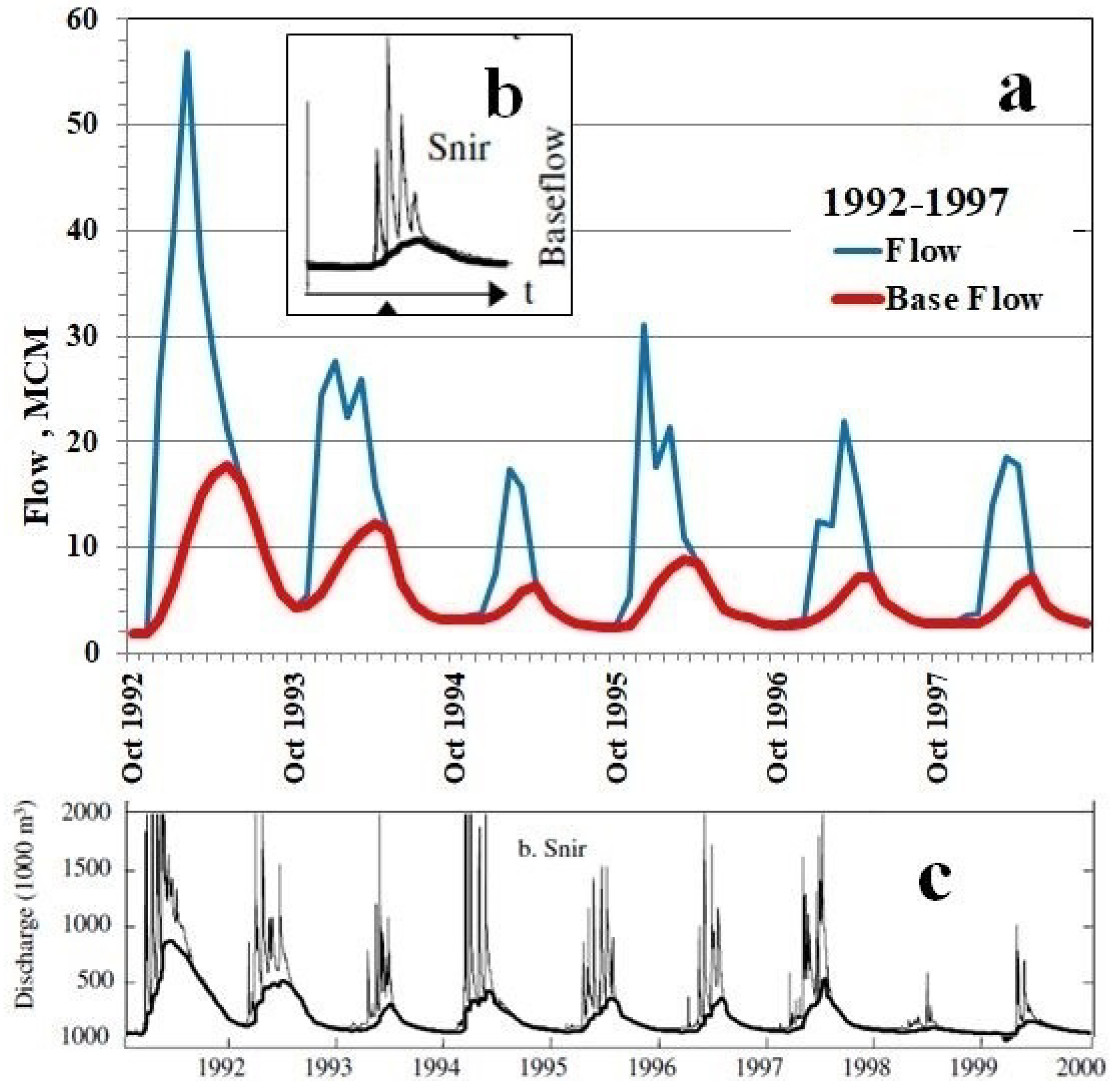
The climate in southern Lebanon is Mediterranean. Precipitation over the Hasbani Basin is characterized by a wet (rainy) season from October to April and by a dry hot season with relatively little to no precipitation from May to September. On Mount Hermon snow usually falls on the elevated areas from December to March, and persists on areas 1400–1900 m a.s.l. and above until March–June (depending on local conditions). The major replenishment of Hasbani River comes from precipitation, as well as from snowmelt and springs which are fed by groundwater from calcareous aquifers recharged by snow and rains. The Hasbani River derives most of its flow from the Wazzani and Hasbani karst springs (Lebanon) with the annual respective contribution of 45 and 30 MCM/y. The rest of the measured discharge is contributed by surface runoff of three tributaries and their seasonal rivulets or flow from other upstream springs. The contribution of the Wazzani spring is very important, since this is the only continuous year-round flow into the river. Water supplies to domestic and agricultural demands in the Hasbani Basin derive from springs, directly from the river and from public and private wells. In this section, origin of data is from [
1,
16,
17,
23,
24,
25,
26,
27,
28].
6. Discussion
6.1. Comparison of Obtained Assessments with Published Values
Published sources offer the following estimates of water use in the Hasbani Basin in Lebanon: 7 MCM/y [
1], 8 MCM/y [
25,
26,
28], and 9-11 MCM/y [
1,
27,
65]. These low estimates (generally without mention of specific years) were commented by authors as rough and incomplete, with the evident lack of reliable information, particularly for unmonitored groundwater abstraction. According to the reports of the Israel Hydrological Service [
17,
66], water use in the Hasbani Basin (Lebanon) was assumed to be higher (to 20 MCM/y), but no arguments or estimates were provided.
Of particular interest is the fact that the total water withdrawals in the Hasbani River Basin (Lebanon) estimated by the AWW method (see
Section 5.1) exceed by far the previously published estimates of water. Such a significant discrepancy between the results requires a special discussion.
In the first place, attention should be given to the low accuracy of the published estimates, which are most often accompanied by the following author’s comments (presented here not literally but close to the text):
- -
The south of Lebanon in particular lack data on water resources based on accurate, sustained, and reliable observation. There are gaps in data, notably on water use and water quality. Some of the data may be fragmented, outdated, or very rough estimates. Historic water use in the south Lebanon may be more than is normally held, though no estimate based on archival record has been attempted [
27].
- -
Estimates of water use from the Upper Jordan River in Lebanon are greatly compromised by poor data and not solidly supported by metered records [
26].
- -
In the Hasbani Basin, southern Lebanon, there is a lack of authoritative knowledge of regional water resources. At the national level the monitoring of hydrological data is fragmented and unreliable, with no central agency analyzing and disseminating relevant information [
28,
67].
In the Hasbani Basin, 70% of the regional population works in an agricultural sector dominated by small, family-run landholdings [
28]. There are a great number of private wells and most of them are unlicensed and unmonitored. It is noted that “as with other parts of Lebanon, information on abstraction rates from illegal wells is wanting, but any estimate of their actual abstractions cannot be considered as accurate” [
26]. Information pertaining to private wells is difficult to gather because the owners are reluctant to provide any information regarding the depths and discharges of the wells [
25].
Even the number of wells in the Hasbani Basin is uncertain and disputable. According to [
26], the Hasbani catchment is served by 9 public wells (generally for domestic supply to the villages), 27–40 private wells (for irrigation and domestic purposes) are known, of which only 2 wells are monitored. According to [
25], 3 main public wells are used for water supply in the Hasbani basin, 12 wells were drilled in the study area (4 wells are under the supervision of the Water Authority and 8 others are unmonitored), and discussions with local farmers revealed the existence of 27 additional private wells, most of which are not registered.
The FAO declared that it is practically impossible to determine the exact figure for groundwater abstraction in the Hasbani Basin [
8]. By [
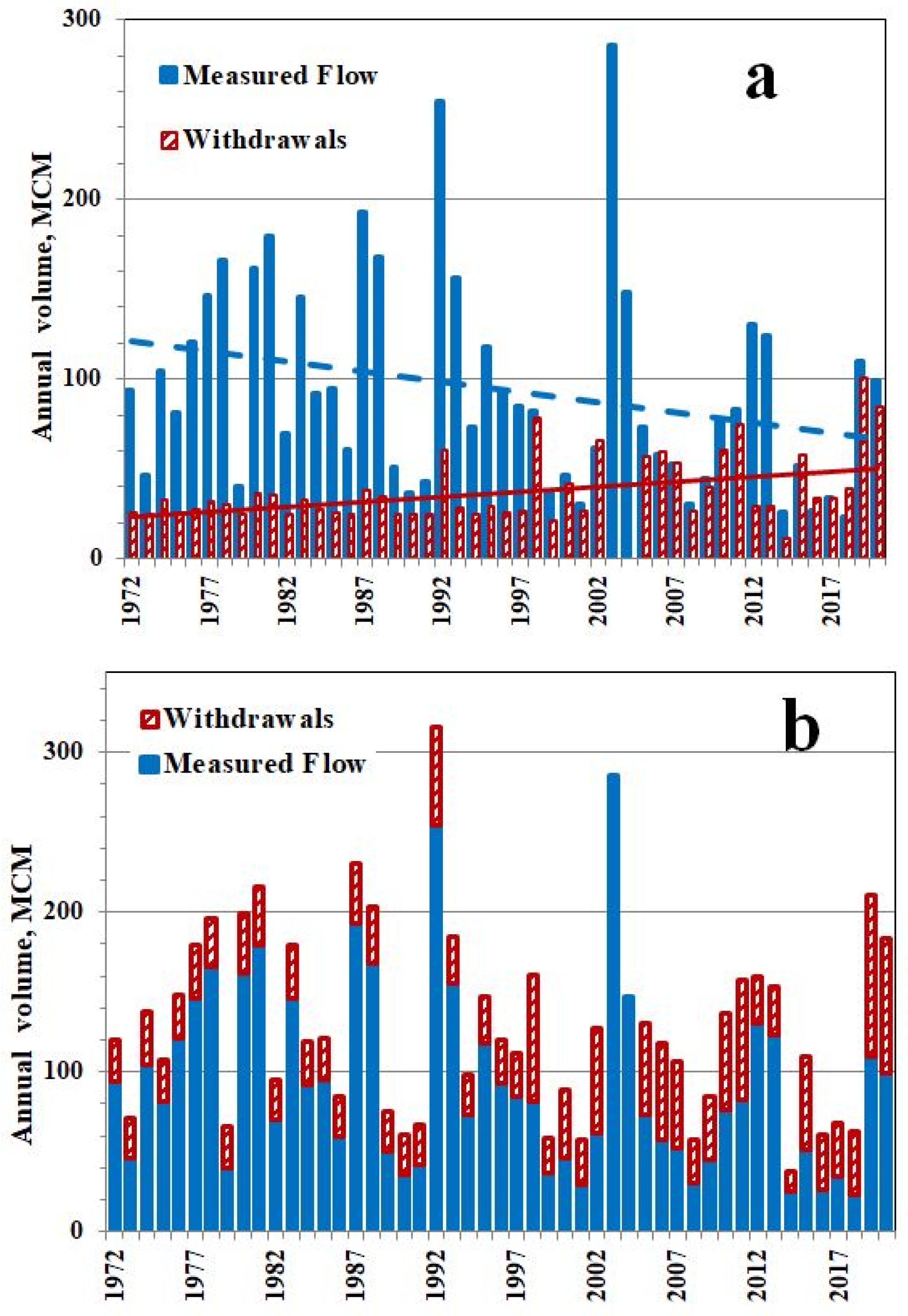
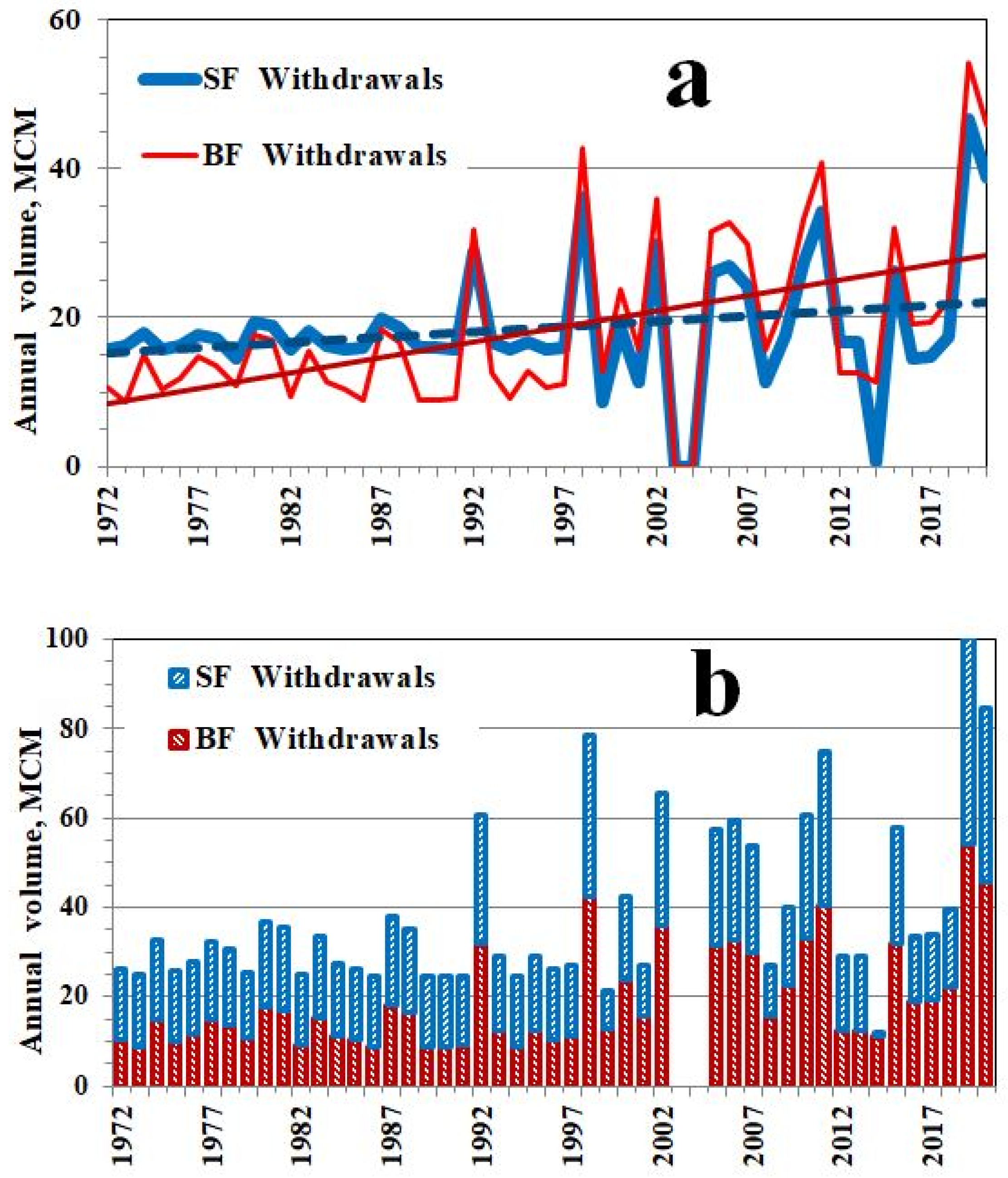
26], the rough estimate (11 MCM/y) of the Hasbani water used in Lebanon for local irrigation and drinking water includes about 4.4 MCM/y of groundwater abstracted from licensed and unlicensed wells. Unlike it, in the present paper the total withdrawals from the Hasbani River are estimated (by the AWW method) at 30 MCM/y (1972–1983) and 48 MCM/y (2008–2020) including respectively 13 MCM/y and 26 MCM/y as the base flow component (
Table 2 and
Table 6). The latter increase is undoubtedly caused by increased number of private (mainly unregistered) wells. By indirect indices (areas of irrigated land, population, and water consumption rates), the total (irrigation and domestic) water use in the Hasbani Basin (before 2011) is estimated as no less than 29 MCM/y (
Section 5.3). This figure supports value of 34 MCM/y which in the present study is the calculated water withdrawals for 1972–2010.
It should be noted that water withdrawals estimated in this study are of the same order as Lebanon’s share of Jordan River water use (of 35 MCM/y) under the Johnston Plan Allocation. The Johnston Plan (referring only to surface flow) was proposed to the riparian countries in 1955 but was never ratified. Nevertheless, it became a benchmark for water management and negotiations in the Jordan River basin [
1,
65,
68].
Substantial issues for further consideration are: (i) What water withdrawals means? (ii) how efficiently the abstracted water is used? and (iii) which part of the water use has been accounted for in published estimates (as stated above, incomplete, rough and etc.,)? The answer to the first question is discussed in the next section. Regarding the second question, a large share of water in the distribution systems is lost through leakages (partly recharging the local aquifer). FAO reported 35–50% seepage from the public water supply networks in Lebanon [
8]. One would not expect a better situation in the private sector. The answer to the third question remains uncertain.
6.2. Flow Trend Attribution: What Are Water Withdrawals?
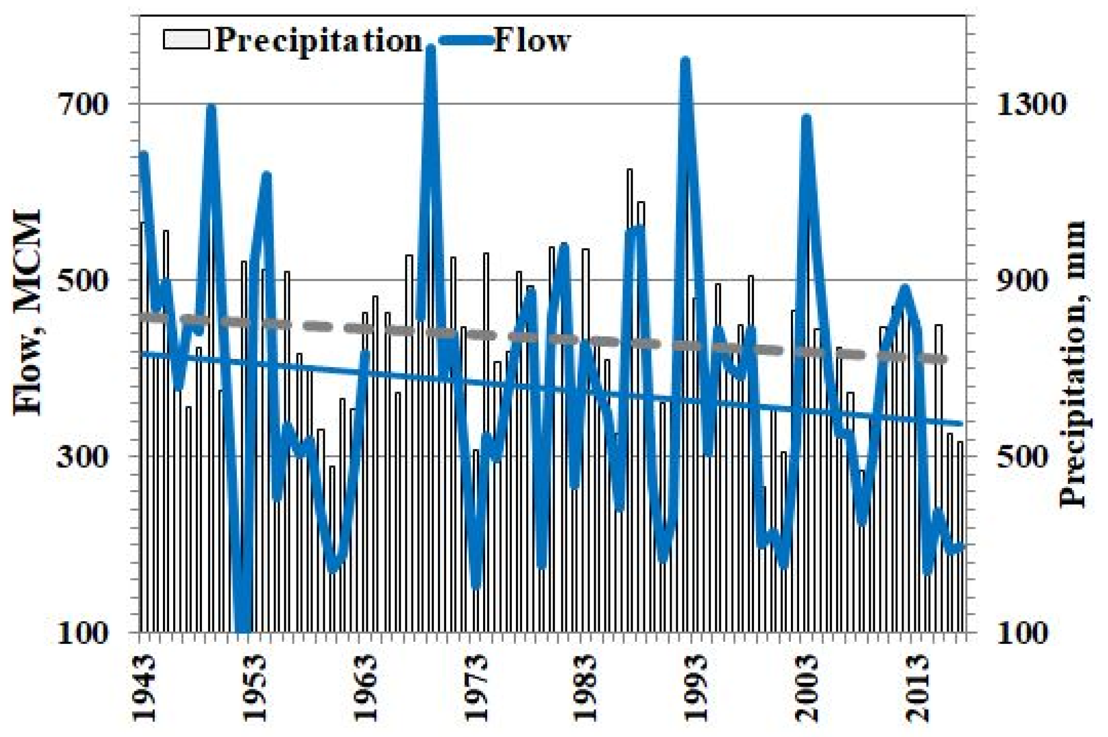
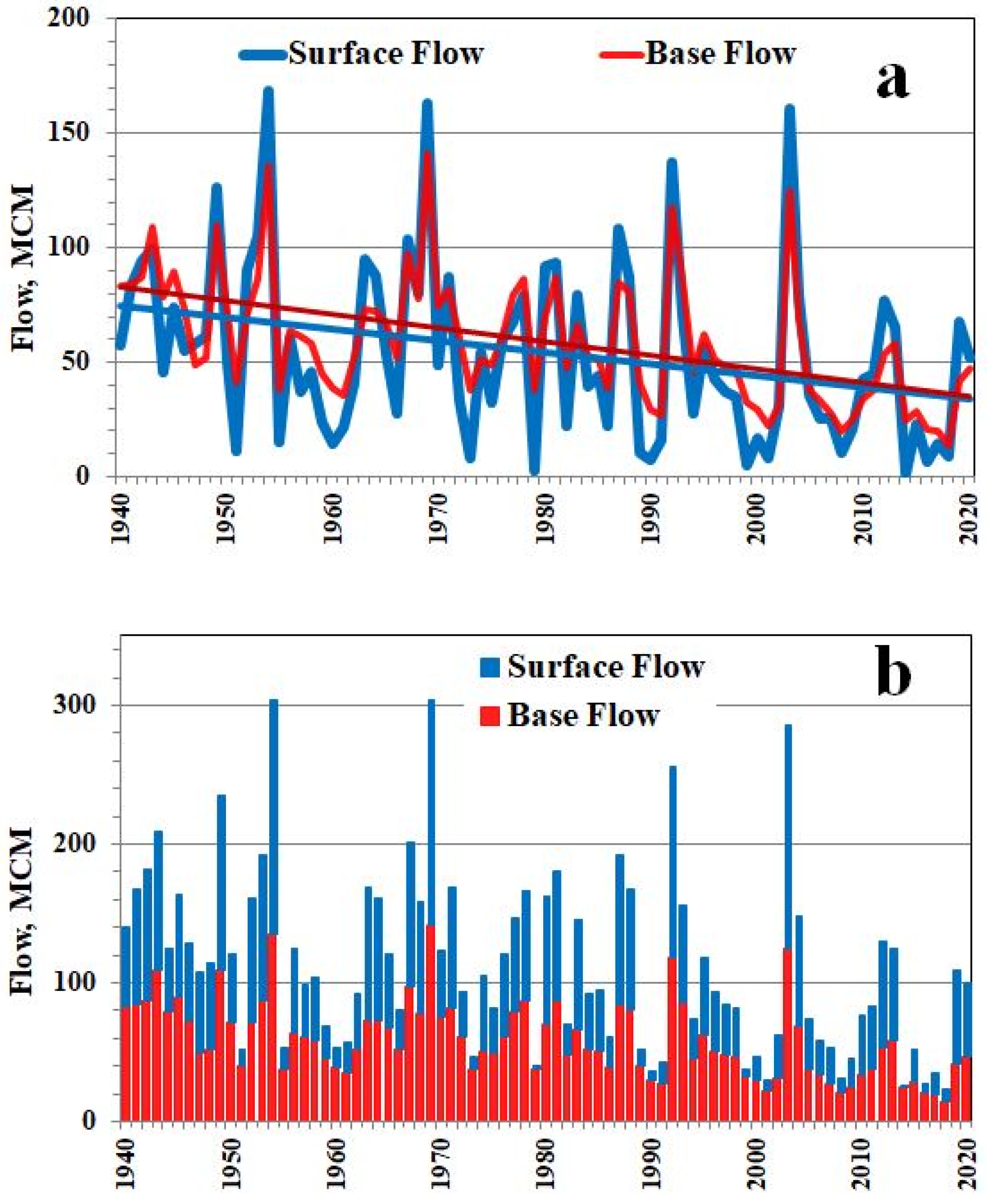
In the present study, the statistically significant decreasing trend in precipitation and flow of the Hasbani River, as well as the relationship between them is detected and confirmed. This means that a decrease in precipitation (climate signal) can be considered as an obvious driving force behind a decrease in flow. But this driver is not the only one, as the drop in flow exceeds the decreasing trend in precipitation.
Further analysis revealed the dynamic nature of the PF relationship, which indicated a consistent flow decline in subsequent sub-periods when with the same precipitation in the basin, less and less runoff was measured at the downstream station. Most likely, this effect is associated with some water withdrawals primarily caused by human activities in the basin (development of irrigation, economic needs, etc.,). However the influence of other factors is not excluded. So far, we used the term “withdrawals” without detailed interpretation, assuming (by the AWW method definition) that withdrawals are the total amount of water removed from the river (or did not reach it) and not included in the measured flow. Estimates of indirect indices (irrigated land area, population, and water consumption rates) confirmed that water use is a significant driving force behind a decrease in the Hasbani flow and almost completely explains the amount of water withdrawals. Attributing flow changes to other specific drivers (apart from decrease in precipitation and developing water use) is discussed further in this section.
First of all, this refers to the global air warming hypothesis, according to which increase in air temperature leads to increase in evapotranspiration and decrease in flow. For the Jordan River headwaters, potential evapotranspiration (PET) was estimated from daily minimum and maximum temperature data in the Har Qnaan weather station along with extraterrestrial solar radiation [
19,
69]. While rising temperature in the basin is statistically significant and the calculated annual PET increases from 1130 mm in 1984–1988 to 1160 mm in the 2007–2016 period, this change (about 2.6%) is too small to explain meaningfully the observed streamflow decreases. This is confirmed by the following simplified calculation. If the change in PET (2.6%) is roughly (as an upper and unrealistically high limit) attributed to the actual annual evapotranspiration (ET) in the Hasbani Basin (from 226 mm [
16] to 238 mm [
70]), then the increase in ET is estimated as less than 5–6 mm (or 3–4 MCM) for 1984–2016 period. This means that global air warming can be considered as only a secondary driver for reducing the Hasbani flow (in compare with
Figure 2 and
Table 2).
In the present study, the latter conclusion is confirmed by assessing the possible impact of the global air warming on the Hasbani surface flow decrease. This effect can be estimated as not higher than 1 MCM during 1972–2007, assuming that it only caused a slight increase in surface flow withdrawals during this period (
Table 6).
Further, the influence of previous dry years on the Hasbani flow decrease was considered as a possible driver. Such effect of “hydrological memory” (or “drought hypothesis”) was found for incoming water to the Lake Kinneret [
10,
71] and for the Dan spring flow [
9,
16] (in consideration of one previous year and three previous years, respectively). In the present case, such effect could be real due to the facts that more than half of the Hasbani basin area is represented by karst exposures and the river is fed mainly by springs. The impact of the previous dry year on flow and water withdrawals in the current year was analyzed within the AWW method. As a result, a slight tendency was revealed, which turned out to be statistically insignificant against the influence of water use.
Summing up the above discussion, the following can be argued:
- -
Decrease in precipitation (climate signal) and human activities in the basin (anthropogenic factor) are the main driving forces behind a decrease in the Hasbani flow.
- -
Global air warming can be considered only as a secondary driver for reducing the Hasbani flow.
- -
Water withdrawals from the Hasbani River estimated by the AWW method are generally results of the human water use with a negligible contribution due to global air warming.
Thus, the estimates of water withdrawals and water use are quite comparable. Moreover, it is quite possible to assume that for water resources management or for assessing the water balance in a transboundary basin, it can be more important to assess exactly withdrawals (as a water deficit) than the water consumption.
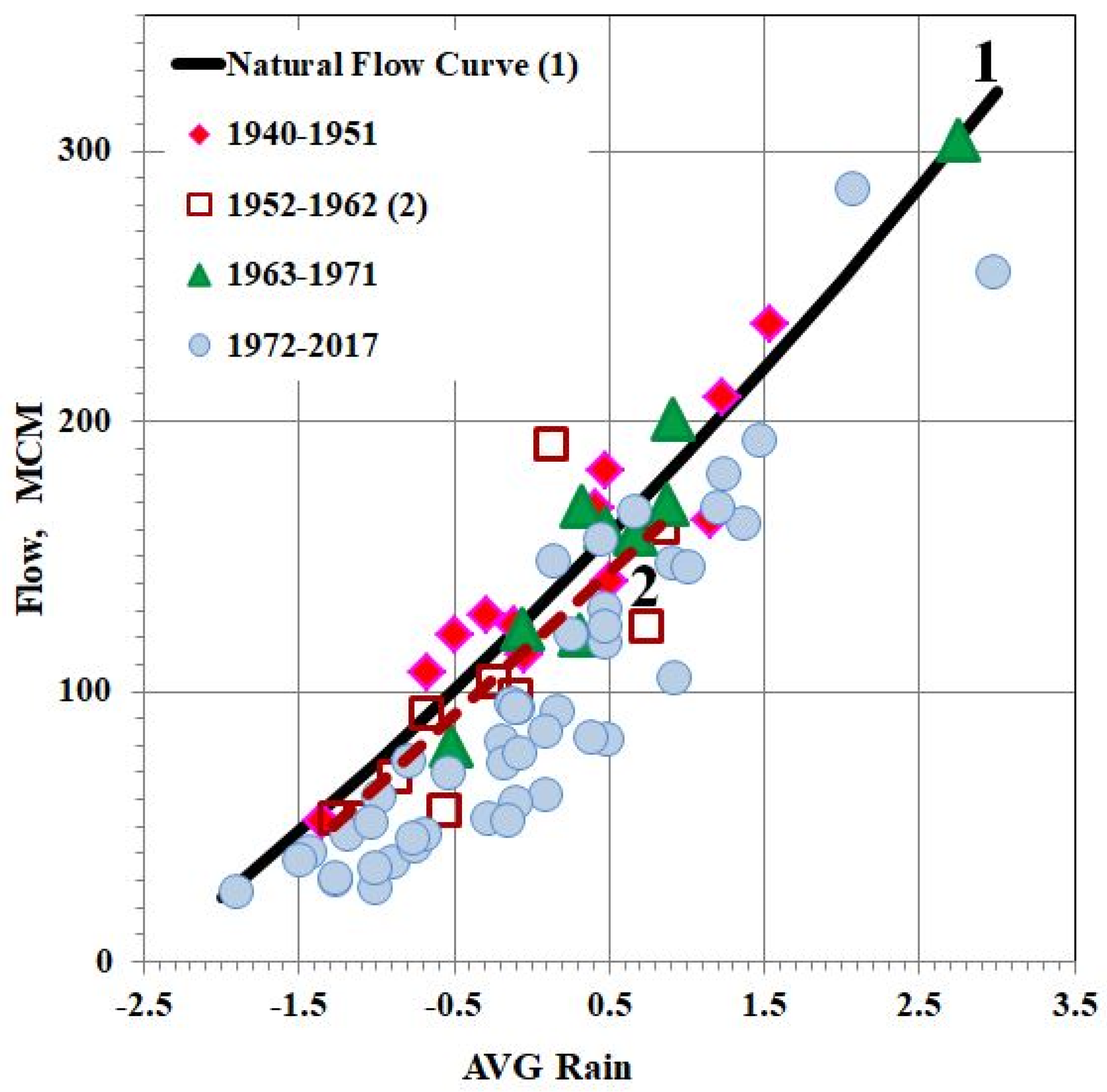
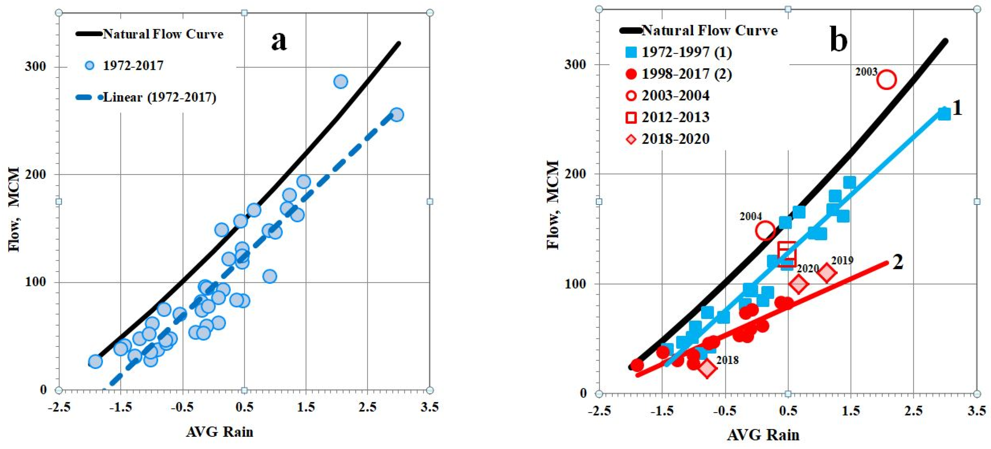
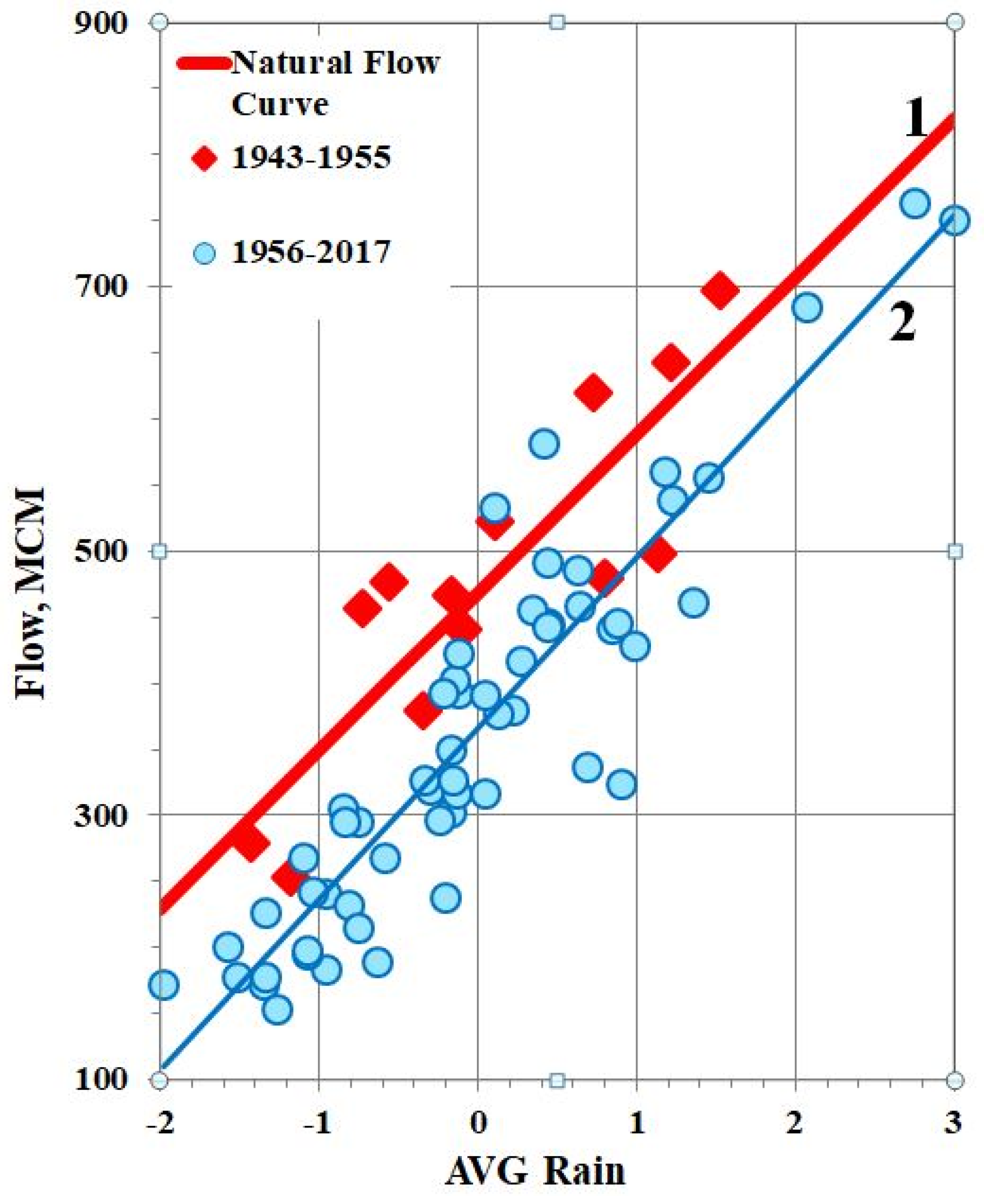
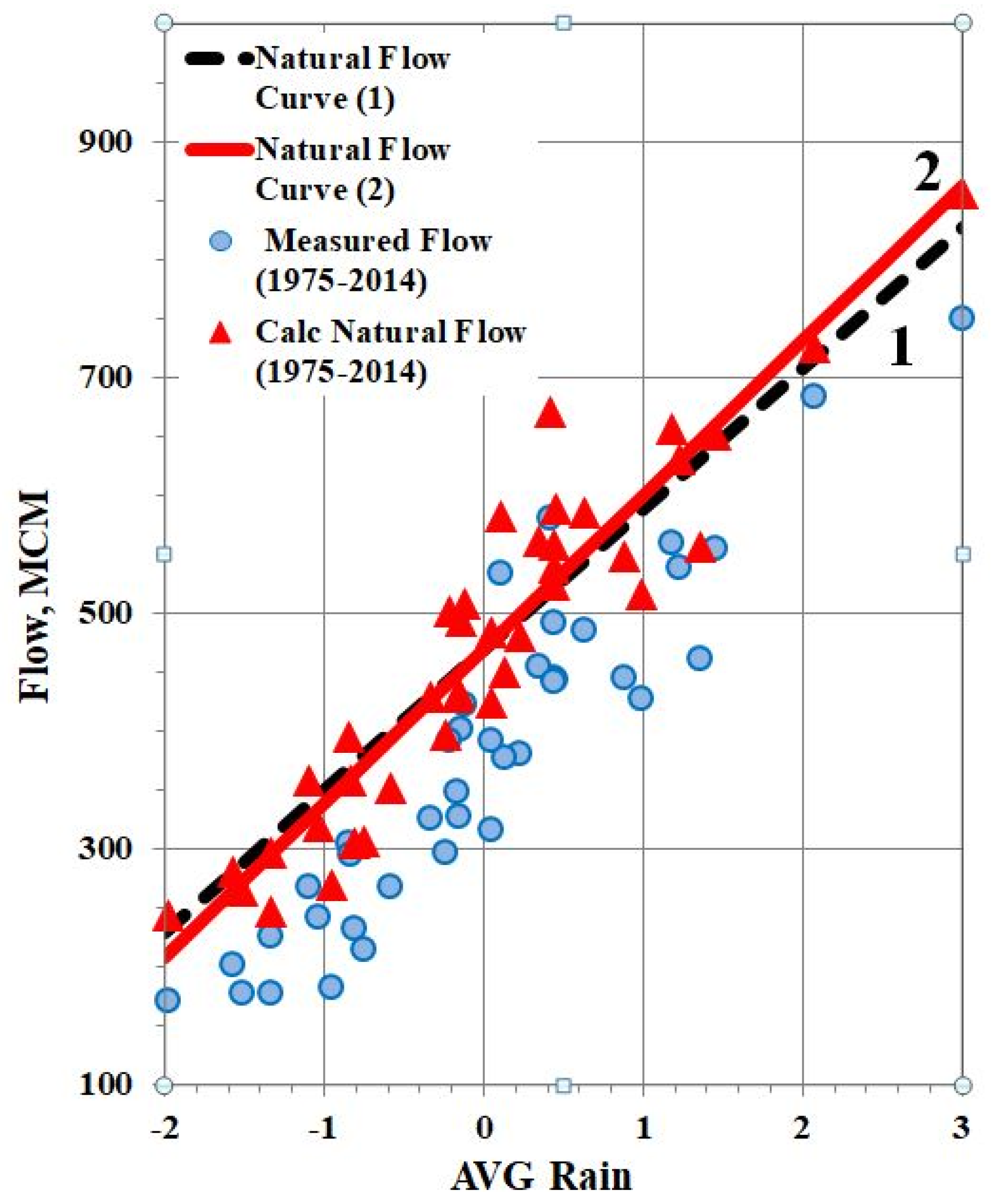
It is important to reiterate that the AWW method enables to differentiate between climatic and anthropogenic impacts on the river flow decrease. This follows from the definition of the AWW method, since the dynamics of the precipitation–flow relationship is analyzed, and not only the trend to a decrease in the flow. Therefore the present study enabled to estimate the relative contribution of two main drivers to the observed decrease of flow. As it was confirmed, a decrease in precipitation is an obvious driving force behind a decrease in the Hasbani flow. Correlation coefficient (R) between precipitation and measured flow (1972–2020) is 0.918, i.e., this driver describes 84% of variance (or dispersion, D) of flow. For natural flow (sum of measured flow and calculated withdrawals) these values are estimated as R = 0.974 and D = 95%, i.e., 11% more taking into consideration the water withdrawals as a balance component of flow.
On the other hand, regarding results of trend analysis, the statistically significant decrease in precipitation and flow of the Hasbani River (1972–2020) was detected as following: for precipitation–15%; for measured flow–45%; and for natural flow (sum of measured flow and calculated withdrawals–19%. As can be seen, in the absence of water withdrawals, the drop in natural flow would be slowed by 26% compared to the trend in measured flow and would approach the trend in precipitation. The latter (i) provides evidence that in this case water use is a more responsible driver in reducing flow than precipitation, and (ii) serves (together with
Figure 7) as verification of the AWW method applied to the Hasbani River.
7. Conclusions and Recommendations
In the present study, the AWW method was proposed as a nonstandard solution to the problem of assessing water withdrawals in the scarce-data transboundary basin. The method operates with the open-source available data on precipitation and river flow and thereby overcomes the usual restriction due to lack of data on shared water use in the Middle East. Analysis of dynamic precipitation-flow relationships enabled to separate the effect of water withdrawals from the total decline of river flow under the decreasing precipitation.
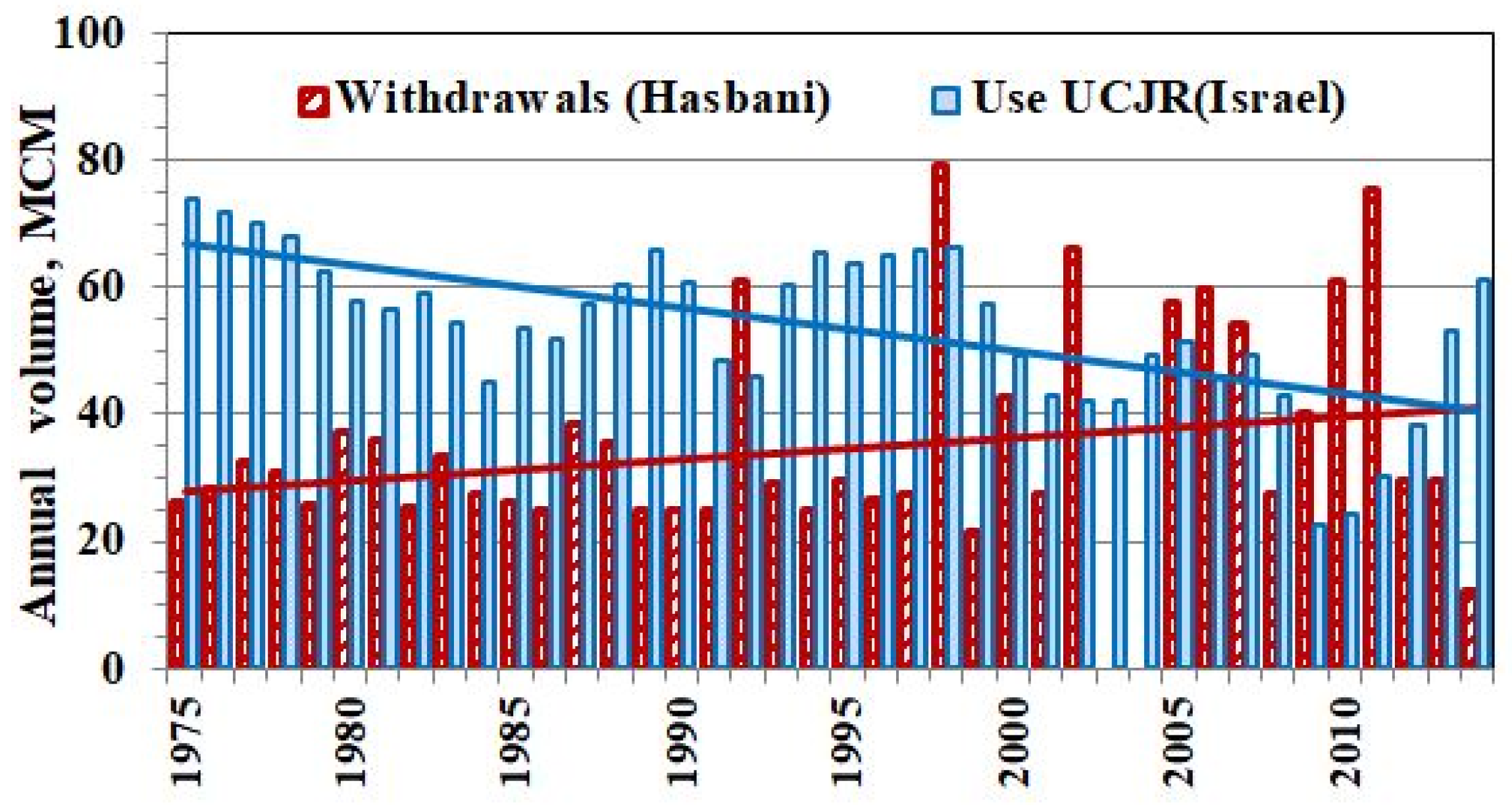
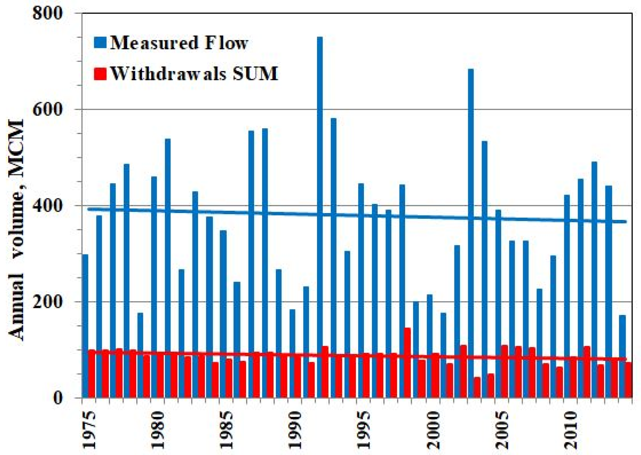
According to the published sources, the present study is the first which provided the complete and rather detailed estimates of water withdrawals from total, surface, and groundwater flow of the Hasbani River in Lebanon (1972–2020). The obtained estimates were confirmed by indirect indices such as area of the irrigated agricultural land and population in the Hasbani Basin. The strong argument in support of the results was validation of the AWW method based on the independent data on water use in the Israeli part of Upper Catchments of the Jordan River (1975–2014, Israel Water Authority).
Careful study revealed and confirmed that (i) decrease in precipitation (climate signal) and developed human activities in the basin (anthropogenic factor) are the main driving forces behind a decrease in the Hasbani flow, and (ii) water withdrawals estimated by the AWW method are generally the results of water use with a negligible contribution of increase in evapotranspiration due to global air warming.
The results of the study are useful for water balance estimations, as well as for management of water resources in the Jordan River headwaters basin and in the entire Lake Kinneret Basin.
The current research should not be regarded only as a regional study but it offers a general approach to solving similar problems. The AWW method can be applied to other transboundary basins under conditions of uncertain (or limited) data on water use, but subject both to the available precipitation and flow data and to confirmation of main hypotheses formulated in
Section 3.2.
The AWW method enables historical and real-time monitoring of water withdrawals in any riparian state and in the entire transboundary basin. Undoubtedly, reliable data on water demand and water use should be the necessary basis for settlement of problematic transboundary water relations, especially within the current critical situation in the Middle East due to expanding geopolitical, socio-economic, and humanitarian problems.


