
Exploring the Capability of Natural Flood Management Approaches in Groundwater-Dominated Chalk Streams

 ,
,
Abstract
1. Introduction
2. Materials and Methods
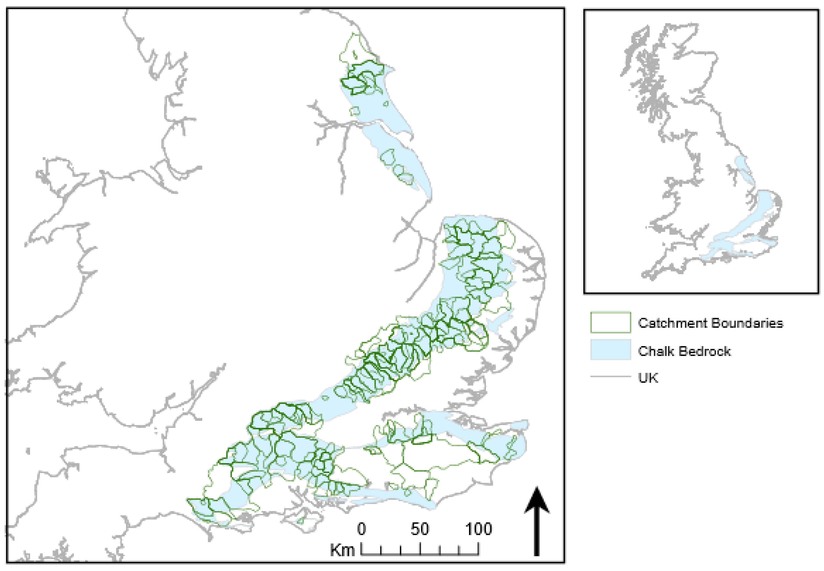
2.1. Study Area and Catchment Selection
2.2. Data Analysis
2.2.1. Hydrological Variables
2.2.2. Physical Catchment Properties
2.3. Statistical Analysis
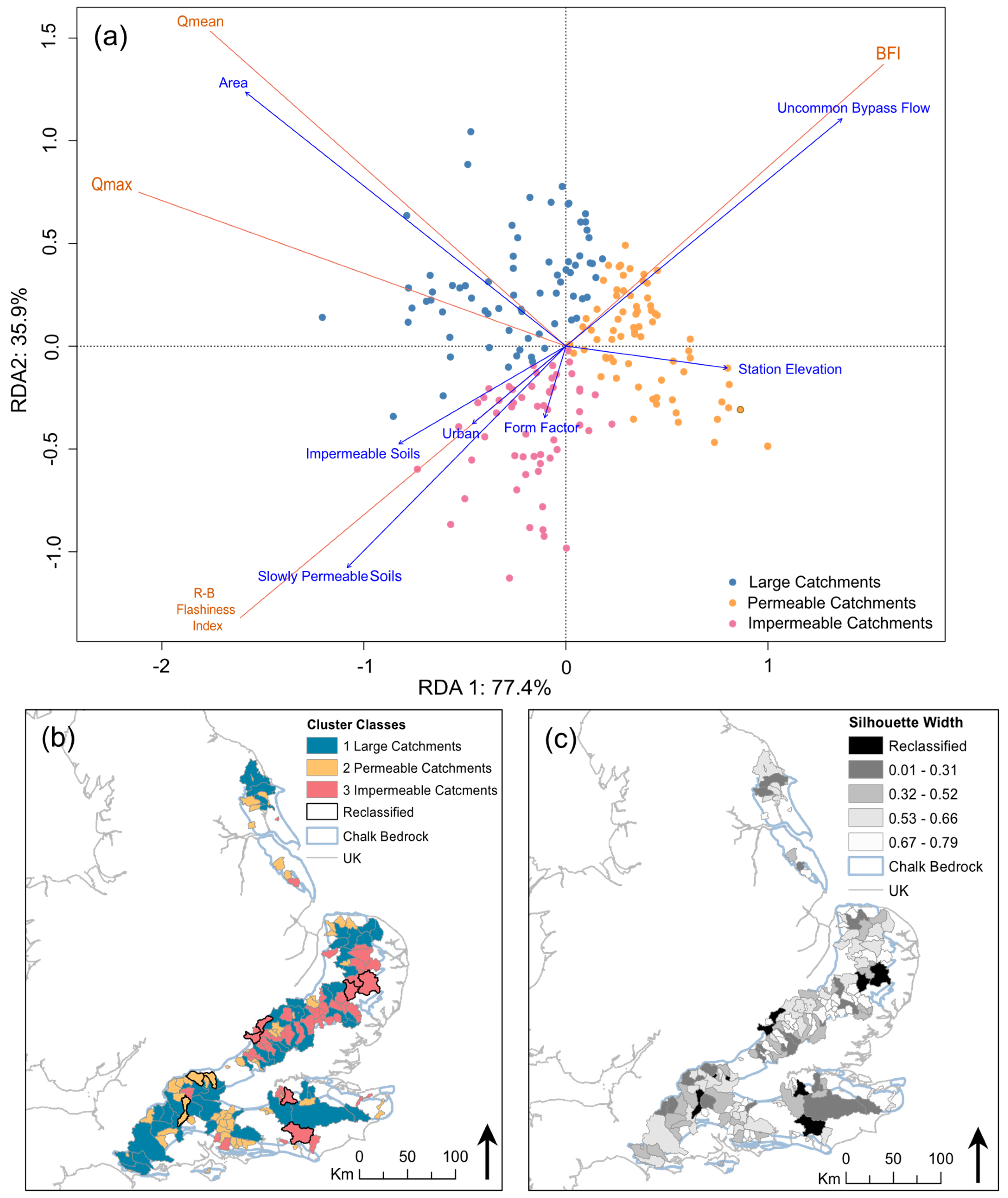
Catchment Classification
3. Results
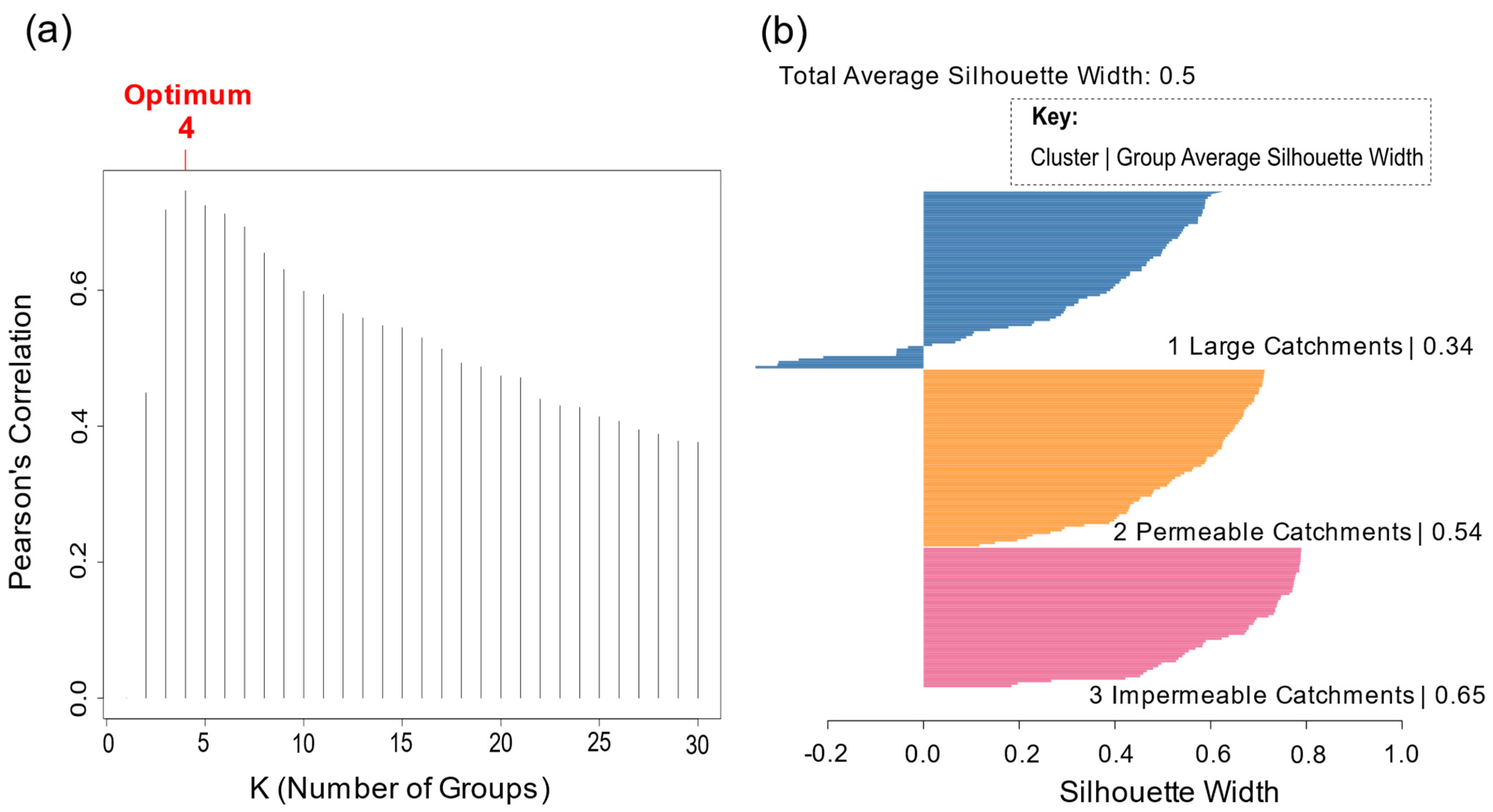
Clustering and Cluster Validation
4. Discussion
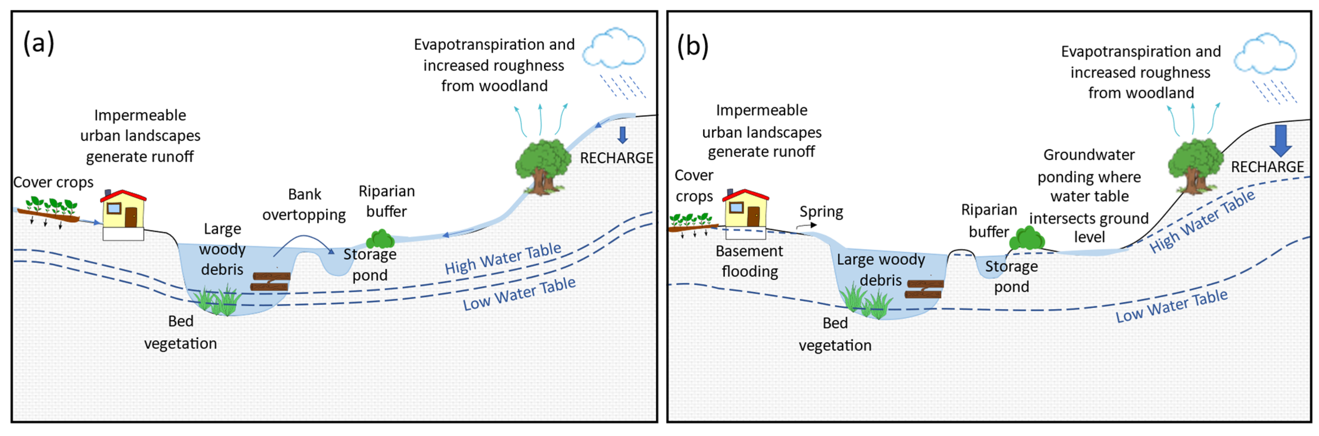
4.1. Group 1: Large Catchments
4.2. Group 2: Permeable Catchments
4.3. Group 3: Less Permeable Catchments
4.4. Applications of NFM in Chalk Catchments
5. Conclusions
Author Contributions
Funding
Institutional Review Board Statement
Informed Consent Statement
Data Availability Statement
Acknowledgments
Conflicts of Interest
Appendix A. Catchments in Their Groups after Redundancy Analysis
| Group 1—Large Catchments | |||||
| No. | Station Number | River | Location | Catchment Area (km2) | Alternative Group Where Classification Is Uncertain |
| 1 | 26001 | West Beck | Wansford Bridge | 195.56 | |
| 2 | 26002 | Hull | Hempholme Lock | 397.23 | |
| 3 | 26004 | Gypsey Race | Bridlington | 257.15 | |
| 4 | 26005 | Gypsey Race | Boynton | 248.13 | 2 |
| 5 | 26009 | West Beck | Snakeholme Lock | 195.61 | |
| 6 | 27087 | Derwent | Low Marishes | 475.93 | |
| 7 | 33003 | Cam | Bossington | 807.32 | |
| 8 | 33004 | Lark | Isleham | 464.16 | |
| 9 | 33006 | Wissey | Northwold Total | 259.36 | |
| 10 | 33007 | Nar | Marham | 147.39 | |
| 11 | 33013 | Sapiston | Rectory Bridge | 196.16 | |
| 12 | 33014 | Lark | Temple | 274.04 | |
| 13 | 33016 | Cam | Jesus Lock | 769.19 | |
| 14 | 33019 | Thet | Melford Bridge | 311.38 | |
| 15 | 33021 | Rhee | Burnt Mill | 308.05 | |
| 16 | 33022 | Ivel | Blunham | 539.63 | |
| 17 | 33023 | Lea Brook | Beck Bridge | 131.89 | 3 |
| 18 | 33024 | Cam | Dernford | 199.59 | |
| 19 | 33028 | Flit | Shefford | 119.42 | |
| 20 | 33034 | Little Ouse | Abbey Heath | 707.76 | |
| 21 | 33044 | Thet | Bridgham | 274.99 | |
| 22 | 33057 | Ouzel | Leighton Buzzrad | 122.40 | |
| 23 | 34003 | Bure | Ingworth | 161.27 | |
| 24 | 34004 | Wensum | Costessey Mill | 559.70 | |
| 25 | 34006 | Waveney | Needham Mill | 376.08 | |
| 26 | 34011 | Wensum | Fakenham | 162.93 | 2 |
| 27 | 34014 | Wensum | Swantom Morely Total | 377.46 | |
| 28 | 34019 | Bure | Horstead Mill | 327.91 | |
| 29 | 36001 | Stour | Stratford St Mary | 838.01 | |
| 30 | 36006 | Stour | Langham | 571.35 | |
| 31 | 36015 | Stour | Lamarsh | 481.28 | 3 |
| 32 | 38001 | Lee | Feildes Weir | 1045.10 | |
| 33 | 38018 | Upper Lee | Water Hall | 157.73 | 3 |
| 34 | 38031 | Lee | Rye Bridge | 758.52 | |
| 35 | 39003 | Wandle | South Wimbledon | 153.73 | |
| 36 | 39010 | Colne | Denham | 725.90 | |
| 37 | 39013 | Colne | Berrygrove | 349.25 | 3 |
| 38 | 39016 | Kennet | Theale | 1037.87 | |
| 39 | 39019 | Lambourn | Shaw | 235.43 | |
| 40 | 39023 | Wye | Hedsor | 134.18 | 2 |
| 41 | 39027 | Pang | Pangbourne | 175.68 | |
| 42 | 39030 | Gade | Croxley Green | 182.35 | |
| 43 | 39031 | Lambourn | Welford | 158.87 | |
| 44 | 39043 | Kennet | Knighton | 299.17 | 2 |
| 45 | 39078 | Wey (North) | Farnham | 192.60 | 2 |
| 46 | 39103 | Kennet | Newbury | 534.13 | |
| 47 | 39104 | Mole | Esher | 471.36 | |
| 48 | 39115 | Pang | Bucklebury | 108.94 | |
| 49 | 40003 | Medway | Teston | 1261.311 | |
| 50 | 40008 | Great Stour | Wye | 226.40 | 3 |
| 51 | 40011 | Great Stour | Horton | 341.27 | |
| 52 | 40012 | Darent | Hawley | 187.31 | |
| 53 | 40016 | Cray | Crayford | 123.49 | 2 |
| 54 | 40018 | Darent | Lullington | 122.24 | 2 |
| 55 | 41004 | Ouse | Barcombe Mills | 400.61 | |
| 56 | 41009 | Rother | Hardham | 360.77 | |
| 57 | 42010 | Itchen | Highbridge & Allbrook Total | 339.91 | |
| 58 | 42012 | Anton | Fullerton | 186.16 | 2 |
| 59 | 42016 | Itchen | Easton | 234.17 | 2 |
| 60 | 42024 | Test | Chilbolton Total | 478.43 | |
| 61 | 43003 | Avon | East Mills Total | 1459.44 | |
| 62 | 43004 | Bourne | Laverstock | 165.21 | |
| 63 | 43005 | Avon | Amesbury | 326.47 | |
| 64 | 43006 | Nadder | Wilton | 215.63 | |
| 65 | 43007 | Stour | Throop | 1062.09 | |
| 66 | 43008 | Wylye | South Newton | 448.17 | |
| 67 | 43018 | Allen | Walford Mill | 170.82 | 2 |
| 68 | 43024 | Wylye | Stockton Park | 170.89 | 2 |
| 69 | 44001 | Frome | East Stoke Total | 414.59 | |
| 70 | 44002 | Piddle | Baggs Mill | 183.80 | |
| 71 | 44004 | Frome | Dorchester Total | 205.67 | |
| Group 2—Catchments with More Permeable Soils | |||||
| No. | Station Number | River | Location | Catchment Area (km2) | Alternative Group Where Classification Is Uncertain |
| 1 | 26003 | Foston Beck | Foston Mill | 59.59 | |
| 2 | 26006 | Elmswell Beck | Little Driffield | 133.18 | 1 |
| 3 | 26008 | Mires Beck | North Cave | 40.96 | |
| 4 | 26013 | Driffield Trout | Driffield | 53.34 | |
| 5 | 26016 | Gypsey Race | Kirby Grindalythe | 16.98 | |
| 6 | 27073 | Brompton Beck | Snainton Ings | 8.06 | |
| 7 | 29001 | Waithe Beck | Brigsley | 108.75 | |
| 8 | 29003 | Lud | Louth | 56.42 | 3 |
| 9 | 33025 | Babingly | West Newton Mill | 44.69 | |
| 10 | 33032 | Heacham | Heacham | 56.16 | |
| 11 | 33033 | Hiz | Arlesey | 112.96 | |
| 12 | 33040 | Rhee | Ashwell | 2.00 | |
| 13 | 33049 | Stanford Water | Buckenham Tofts | 46.45 | |
| 14 | 33052 | Swaffham Lode | Swaffham Bulbeck | 33.12 | |
| 15 | 33054 | Babingley | Castle Rising | 48.54 | |
| 16 | 33056 | Quy Water | Lode | 92.56 | |
| 17 | 33061 | Shep | Fowlmere One | 1.03 | |
| 18 | 33062 | Guilden Brook | Fowlmere Two | 3.40 | |
| 19 | 33064 | Whaddon Brook | Whaddon | 14.53 | |
| 20 | 33065 | Hiz | Hitchin | 12.03 | |
| 21 | 33068 | Cheney Water | Gatley End | 0.11 | |
| 22 | 34012 | Burn | Burnham Overy | 83.87 | |
| 23 | 34018 | Stiffkey | Warham | 86.13 | 3 |
| 24 | 38017 | Mimram | Whitwell | 38.40 | |
| 25 | 39015 | Whitewater | Lodge Farm | 46.99 | |
| 26 | 39029 | Tilling Bourne | Shalford | 58.78 | |
| 27 | 39032 | Lambourn | East Shefford | 145.06 | 1 |
| 28 | 39033 | Winterbourne Stream | Bagnor | 45.31 | |
| 29 | 39036 | Law Brook | Albury | 16.07 | |
| 30 | 39037 | Kennet | Marlborough | 136.43 | 1 |
| 31 | 39039 | Wye | High Wycombe | 67.73 | |
| 32 | 39061 | Letcombe Brook | Letcombe Bassett | 3.99 | |
| 33 | 39065 | Ewelme Brook | Ewelme | 11.98 | |
| 34 | 39077 | Og | Marlborough Poulton Farm | 63.95 | |
| 35 | 39091 | Misbourne | Quarrendon Mill | 65.87 | |
| 36 | 39101 | Aldbourne | Ramsbury | 53.09 | |
| 37 | 39102 | Misbourne | Denham Lodge | 93.24 | |
| 38 | 39107 | Hogsmill | Ewell | 8.44 | |
| 39 | 39112 | Letcombe Brook | Arabellas Lake | 3.10 | |
| 40 | 39113 | Manor Farm Brook | Letcombe Regis | 1.38 | |
| 41 | 39114 | Pang | Frilsham | 90.06 | |
| 42 | 39118 | Wey | Alton | 44.50 | |
| 43 | 39119 | Wey | Kings Pond (Alton) | 46.15 | |
| 44 | 39120 | Caker Stream | Alton | 83.94 | |
| 45 | 39146 | Mill Brook | Blewbury | 2.01 | |
| 46 | 39147 | Wendover Springs | Wendover | 9.49 | |
| 47 | 40013 | Darent | Otford | 98.19 | |
| 48 | 40014 | Wingham | Durlock | 30.72 | |
| 49 | 40033 | Dour | Crabble Mill | 44.93 | |
| 50 | 41015 | Ems | Westbourne | 57.89 | |
| 51 | 41023 | Lavant | Graylingwell | 86.20 | |
| 52 | 41033 | Costers Brook | Cocking | 2.74 | |
| 53 | 41034 | Ems | Walderton | 42.46 | |
| 54 | 41037 | Winterbourne Stream | Lewes | 17.48 | |
| 55 | 42005 | Wallop Brook | Broughton | 53.46 | |
| 56 | 42006 | Meon | Mislingford | 75.84 | |
| 57 | 42007 | Alre | Drove Lane Alresford | 57.45 | |
| 58 | 42008 | Cheriton Stream | Sewards Bridge | 74.33 | |
| 59 | 42009 | Candover Stream | Borough Bridge | 72.06 | |
| 60 | 42015 | Dever | Weston Colley | 50.15 | |
| 61 | 42025 | Lavant Stream | Leigh Park | 55.96 | |
| 62 | 42026 | Wallop Brook | Bossington | 61.13 | |
| 63 | 42027 | Dever | Bransbury | 122.36 | 1 |
| 64 | 43010 | Allen | Loverley Farm | 94.84 | |
| 65 | 43011 | Ebble | Bodenham | 105.55 | |
| 66 | 43012 | Wylye | Norton Bavant | 114.01 | 1 |
| 67 | 43014 | East Avon | Upavon | 85.82 | |
| 68 | 44006 | Sydling Water | Sydling St Nicholas | 12.05 | |
| 69 | 44008 | South Winterbourne | Winterbourne Steepleton | 20.18 | 3 |
| 70 | 44009 | Wey | Broadwey | 8.00 | |
| 71 | 101003 | Lukely Brook | Carisbrooke Mill | 14.86 | |
| Group 3—Catchments with Less Permeable Soils | |||||
| No. | Station Number | River | Location | Catchment Area (km2) | Alternative Group Where Classification Is Uncertain |
| 1 | 26007 | Catchwater | Withernwick | 10.84 | |
| 2 | 29002 | Great Eau | Claythorpe Mill | 80.42 | |
| 3 | 33011 | Little Ouse | County Bridge Euston | 129.34 | |
| 4 | 33027 | Rhee | Wimpole | 128.49 | |
| 5 | 33029 | Stringside | Whitebridge | 95.41 | |
| 6 | 33030 | Clipstone Brook | Clipstone | 40.35 | |
| 7 | 33045 | Wittle | Quidenham | 27.45 | |
| 8 | 33046 | Thet | Redbridge | 14.43 | |
| 9 | 33050 | Snail | Fordham | 57.88 | |
| 10 | 33051 | Cam | Chesterford | 140.02 | |
| 11 | 33053 | Granta | Stapleford | 113.98 | |
| 12 | 33055 | Granta | Babraham | 101.97 | |
| 13 | 33066 | Granta | Linton | 61.61 | |
| 14 | 33070 | Lark | Fornham St Martin | 111.07 | |
| 15 | 34001 | Yare | Colney | 228.81 | |
| 16 | 34002 | Tas | Shotesham | 153.19 | |
| 17 | 34005 | Tud | Costessey Park | 72.11 | |
| 18 | 36002 | Glem | Glemsford | 85.61 | |
| 19 | 36004 | Chad Brook | Long Melford | 50.33 | |
| 20 | 36005 | Brett | Hadleigh | 155.85 | |
| 21 | 36007 | Belchamp Brook | Bardfield Bridge | 58.16 | |
| 22 | 36008 | Stour | Westmill | 222.82 | |
| 23 | 36009 | Brett | Cockfield | 25.56 | |
| 24 | 36010 | Bumpstead Brook | Broad Green | 27.58 | |
| 25 | 36011 | Stour Brook | Sturmer | 34.24 | |
| 26 | 36012 | Stour | Kedington | 76.65 | |
| 27 | 36013 | Brett | Higham | 191.78 | |
| 28 | 37012 | Colne | Poolstreet | 64.49 | |
| 29 | 37016 | Pant | Copford | 63.80 | |
| 30 | 38002 | Ash | Mardock | 78.00 | |
| 31 | 38003 | Mimram | Panshanger Park | 130.21 | |
| 32 | 38004 | Rib | Wadesmill | 136.79 | |
| 33 | 38005 | Ash | Easneye | 84.65 | |
| 34 | 38006 | Rib | Herts Training School | 148.67 | |
| 35 | 38011 | Mimram | Fulling Mill | 99.25 | |
| 36 | 38012 | Stevenage Brook | Bragbury Brook | 35.11 | |
| 37 | 38013 | Upper Lee | Luton Hoo | 70.31 | |
| 38 | 38028 | Stanstead Brook | Gypsy Lane | 26.37 | 2 |
| 39 | 38029 | Quin | Griggs Bridge | 50.41 | |
| 40 | 38030 | Beane | Hartham | 173.85 | |
| 41 | 39004 | Wandle | Beddington Park | 117.35 | 2 |
| 42 | 39005 | Beverly Brook | Wimbledon Common | 39.49 | |
| 43 | 39012 | Hogsmill | Kingston Upon Thames | 72.91 | |
| 44 | 39014 | Ver | Hansteads | 134.55 | |
| 45 | 39028 | Dun | Hungerford | 100.09 | |
| 46 | 39055 | Yeading Brook West | North Hillingdon | 1.31 | |
| 47 | 39088 | Chess | Rickmansworth | 96.91 | |
| 48 | 39089 | Gade | Bury Mill | 44.73 | |
| 49 | 39125 | Ver | Redbourn | 62.58 | |
| 50 | 39127 | Misbourne | Little Missenden | 47.26 | 2 |
| 51 | 40015 | White Drain | Fairbrook Farm | 31.40 | |
| 52 | 40027 | Sarre Pen | Calcott | 19.59 | |
| 53 | 41003 | Cuckmere | Sherman Bridge | 130.33 | |
| 54 | 41028 | Chess Stream | Chess Bridge | 25.01 | |
| 55 | 42001 | Wallington | North Fareham | 111.68 | |
| 56 | 42011 | Hamble | Frogmill | 55.25 | |
References
- Forbes, H.; Ball, K.; McLay, F. Natural Flood Management Handbook; Scottish Environment Protection Agency: Stirling, Scotland, UK, 2015. [Google Scholar] [CrossRef]
- Quinn, P.; O’donnell, G.; Nicholson, A.; Wilkinson, M.; Owen, G.; Jonczyk, J.; Barber, N.; Hardwick, M.; Davies, G. Potential Use of Runoff Attenuation Features in Small Rural Catchments for Flood Mitigation; Newcastle University: Newcastle upon Tyne, UK, 2013. [Google Scholar]
- SEPA. SEPA Position Statement “The Role of SEPA in Natural Flood Management”; SEPA: Stirling, Scotland, UK, 2012. [Google Scholar]
- Blanc, J.; Arthur, S.; Wright, G. Natural Flood Management (NFM) Knowledge System: Part 3—The Effect of Land Drainage on Flood Risk and Farming Practice; CREW—Centre of Expertise for Waters: Aberdeen, Scotland, UK, 2012. [Google Scholar]
- Jackson, B.; Wheater, H.; McIntyre, N.; Chell, J.; Francis, O.; Frogbrook, Z.; Marshall, M.; Reynolds, B.; Solloway, I. The Impact of Upland Land Management on Flooding: Insights from a Multiscale Experimental and Modelling Programme. J. Flood Risk Manag. 2008, 1, 71–80. [Google Scholar] [CrossRef]
- Schafer, K. Experiments with Catch Crops for Erosions Control in Maize Production. Wirtschaftseigene Futter 1986, 32, 60–71. [Google Scholar]
- Schilling, K.E.; Gassman, P.W.; Kling, C.L.; Campbell, T.; Jha, M.K.; Wolter, C.F.; Arnold, J.G. The Potential for Agricultural Land Use Change to Reduce Flood Risk in a Large Watershed. Hydrol. Process. 2014, 28, 3314–3325. [Google Scholar] [CrossRef]
- Skinner, K.; Haycock, N. Sinderland Brook—1.8 Km of River and Floodplain Restoration Integrated into a New Housing Development. River Restor. News Newsl. River Restor. Cent. 2005, 20, 6–7. [Google Scholar]
- Hankin, B.; Arnott, S.; Whiteman, M.; Burgess-Gamble, L.; Rose, S. Working with Natural Processes—Using Flood Risk Evidence to Make the Case for NFM. 2017. Available online: https://assets.publishing.service.gov.uk/media/6036c7f9d3bf7f0aaa2a45fa/Working_with_natural_processes_using_the_evidence_base.pdf (accessed on 20 October 2017).
- Janes, V.J.; Grabowski, R.C.; Mant, J.; Allen, D.; Morse, J.L.; Haynes, H. The Impacts of Natural Flood Management Approaches on In-Channel Sediment Quality. River Res. Appl. 2016, 33, 89–101. [Google Scholar] [CrossRef]
- Dadson, S.J.; Hall, J.W.; Murgatroyd, A.; Acreman, M.; Bates, P.; Beven, K.; Heathwaite, A.L.; Holden, J.; Holman, I.; Lane, S.N.; et al. A Restatement of the Natural Science Evidence Concerning Catchment-Based ‘natural’ Flood Management in the UK. Proc. R. Soc. A Math. Phys. Eng. Sci. 2017, 473, 20160706. [Google Scholar] [CrossRef]
- Nicholson, A.R.; Wilkinson, M.E.; O’Donnell, G.M.; Quinn, P.F. Runoff Attenuation Features: A Sustainable Flood Mitigation Strategy in the Belford Catchment, UK. Area 2012, 44, 463–469. [Google Scholar] [CrossRef]
- Lane, S.N. Natural Flood Management. Wiley Interdiscip. Rev. Water 2017, 4, 1211. [Google Scholar] [CrossRef]
- Pitt, M. The Pitt Review: Learning Lessons from the 2007 Floods. 2008. Available online: http://webarchive.nationalarchives.gov.uk/20100812084907/http://archive.cabinetoffice.gov.uk/pittreview/_/media/assets/www.cabinetoffice.gov.uk/flooding_review/pitt_review_full pdf.pdf (accessed on 24 July 2018).
- O’Neill, R.; Hughes, K. The State of England’s Chalk Streams. 2014. Available online: http://assets.wwf.org.uk/downloads/wwf_chalkstreamreport_final_lr.pdf (accessed on 1 June 2020).
- Sear, D.A.; Armitage, P.D.; Dawson, F.H. Groundwater Dominated Rivers. Hydrol. Process. 1999, 13, 255–276. [Google Scholar] [CrossRef]
- Berrie, A.D. The Chalk-Stream Environment. Hydrobiology 1992, 248, 3–9. [Google Scholar] [CrossRef]
- Wood, P.; Hannah, D.; Agnew, M.; Petts, G. Scales of Hydroecological Variability Within a Groundwater-Dominated Stream. Regul. Rivers Res. Manag. 2001, 17, 347–367. [Google Scholar] [CrossRef]
- Lamontagne, S.; Taylor, A.R.; Cook, P.G.; Crosbie, R.S.; Brownbill, R.; Williams, R.M.; Brunner, P. Field Assessment of Surface Water-Groundwater Connectivity in a Semi-Arid River Basin (Murray-Darling, Australia). Hydrol. Process. 2012, 28, 1561–1572. [Google Scholar] [CrossRef]
- Naughton, O.; McCormack, T.; Gill, L.; Johnston, P. Groundwater Flood Hazards and Mechanisms in Lowland Karst Terrains. Geol. Soc. London Spec. Publ. 2018, 466, 397–410. [Google Scholar] [CrossRef]
- Barber, N.J.; Quinn, P.F. Mitigating Diffuse Water Pollution from Agriculture Using Soft-Engineered Runoff Attenuation Features. Area 2012, 44, 454–462. [Google Scholar] [CrossRef]
- Mclean, L.; Beevers, L.; Pender, G.; Haynes, H.; Beevers, L.G.; Pender, H.; Haynes, M.; Wilkinson, J. Variables for measuring multiple benefits and ecosystem services. In Proceedings of the Infrastructure and Environment Scotland 1st Postgraduate Conference, Heriot-Watt University, Edinburgh, UK, 3 June 2013; Available online: https://www.researchgate.net/Publication/271433811 (accessed on 14 May 2019).
- The Environment Agency. Working with Natural Processes-Using the Evidence Base to Make the Case for Natural Flood Management SC150005. 2017. Available online: https://assets.publishing.service.gov.uk/media/6036c7f9d3bf7f0aaa2a45fa/Working_with_natural_processes_using_the_evidence_base.pdf (accessed on 16 July 2018).
- Boorman, D.B.; Hollist, J.M.; Lilly, A. Hydrology of Soil Types: A Hydrologically-Based Classification of the Soils of the United Kingdom. 1995. Available online: http://nora.nerc.ac.uk/id/eprint/7369/1/IH_126.pdf (accessed on 23 October 2019).
- Gustard, A.; Bullock, A.; Dixon, J.M. Low Flow Estimation in the United Kingdom. Report; UK Institute of Hydrology: Wallingford, UK, 1992; Number 108. [Google Scholar]
- Fry, M.J.; Swain, O. Hydrological Data Management Systems Within a National River Flow Archive. In Role of Hydrology in Managing Consequences of a Changing Global Environment. Proceedings of the BHS Third International Symposium; Kirby, C., Ed.; British Hydrological Society: London, UK, 2010; pp. 808–815. [Google Scholar]
- Smith, A. A New Edition of the Bedrock Geology Map of the United Kingdom. J. Maps 2009, 5, 232–252. [Google Scholar] [CrossRef][Green Version]
- Downing, R.A.; Edmunds, W.M.; Gale, I.N. Regional Groundwater Flow in Sedimentary Basins in the U.K. Geol. Soc. London Spec. Publ. 1987, 34, 105–125. [Google Scholar] [CrossRef]
- Baker, D.B.; Richards, R.P.; Loftus, T.T.; Kramer, J.W. A New Flashiness INDEX: Characteristics and Applications to Midwestern Rivers and Streams. JAWRA J. Am. Water Resour. Assoc. 2004, 40, 503–522. [Google Scholar] [CrossRef]
- Al-Saady, Y.I.; Al-Suhail, Q.A.; Al-Tawash, B.S.; Othman, A.A. Drainage Network Extraction and Morphometric Analysis Using Remote Sensing and GIS Mapping Techniques (Lesser Zab River Basin, Iraq and Iran). Environ. Earth Sci. 2016, 75, 1243. [Google Scholar] [CrossRef]
- Ascott, M.J.; Marchant, B.P.; Macdonald, D.; McKenzie, A.A.; Bloomfield, J. Improved Understanding of Spatio-Temporal Controls on Regional Scale Groundwater Flooding Using Hydrograph Analysis and Impulse Response Functions. Hydrol. Process. 2017, 31, 4586–4599. [Google Scholar] [CrossRef]
- NERC; CEH. Land Cover Map 2015: Dataset Documentation. 2017. Available online: www.ceh.ac.Uk (accessed on 1 April 2019).
- Ogden, F.L.; Pradhan, N.R.; Downer, C.W.; Zahner, J.A. Relative Importance of Impervious Area, Drainage Density, Width Function, and Subsurface Storm Drainage on Flood Runoff from an Urbanized Catchment. Water Resour. Res. 2011, 47. [Google Scholar] [CrossRef]
- Strahler, A.N. Quantitative Geomorphology. Quantitative geomorphology. In Geomorphology. Encyclopedia of Earth Science; Springer: Berlin/Heidelberg, Germany, 1968. [Google Scholar]
- Allen, D.J.; Brewerton, L.J.; Coleby, L.M.; Gibbs, B.R.; Lewis, M.A.; Macdonald, A.M.; Wagstaff, S.J.; Williams, A.T. The Physical Properties of Major Aquifers in England and Wales; British Geological Survey Technical Report WD/97/034; British Geological Survey: Keyworth, UK, 1997; p. 333. [Google Scholar]
- MacDonald, A.; Allen, D.J. Aquifer Properties of the Chalk of England. Q. J. Eng. Geol. Hydrogeol. 2001, 34, 371–384. [Google Scholar] [CrossRef]
- Holko, L.; Parajka, J.; Kostka, Z.; Škoda, P.; Blöschl, G. Flashiness of Mountain Streams in Slovakia and Austria. J. Hydrol. 2011, 405, 392–401. [Google Scholar] [CrossRef]
- Sabo, J.L.; Finlay, J.; Kennedy, T.; Post, D. The Role of Discharge Variation in Scaling of Drainage Area and Food Chain Length in Rivers. Science 2010, 330, 965–967. [Google Scholar] [CrossRef] [PubMed]
- Sherman, L.K. The Relation of Hydrographs of Runoff to Size and Character of Drainage-Basins. Trans. Am. Geophys. Union 1932, 13, 332–339. [Google Scholar] [CrossRef]
- Farr, T.G.; Rosen, P.A.; Caro, E.; Crippen, R.; Duren, R.; Hensley, S.; Kobrick, M.; Paller, M.; Rodriguez, E.; Roth, L.; et al. The Shuttle Radar Topography Mission. Rev. Geophys. 2007, 45. [Google Scholar] [CrossRef]
- O’Connell, P.E.; Ewen, J.; O’Donnell, G.; Quinn, P. Is There a Link Between Agricultural Land-Use Management and Flooding? Hydrol. Earth Syst. Sci. 2007, 11, 96–107. [Google Scholar] [CrossRef]
- Nirupama, N.; Simonovic, S.P. Increase of Flood Risk Due to Urbanisation: A Canadian Example. Nat. Hazards 2007, 40, 25–41. [Google Scholar] [CrossRef]
- Alaoui, A.; Caduff, U.; Gerke, H.H.; Weingartner, R. Preferential Flow Effects on Infiltration and Runoff in Grassland and Forest Soils. Vadose Zone J. 2011, 10, 367–377. [Google Scholar] [CrossRef]
- Granged, A.J.; Zavala, L.M.M.; Jordán, A.; Bárcenas-Moreno, G. Post-Fire Evolution of Soil Properties and Vegetation Cover in a Mediterranean Heathland After Experimental Burning: A 3-Year Study. Geoderma 2011, 164, 85–94. [Google Scholar] [CrossRef]
- Miller, J.; Kim, H.; Kjeldsen, T.R.; Packman, J.; Grebby, S.; Dearden, R. Assessing the Impact of Urbanization on Storm Runoff in a Peri-Urban Catchment Using Historical Change in Impervious Cover. J. Hydrol. 2014, 515, 59–70. [Google Scholar] [CrossRef]
- Wong, L.; Hashim, R.; Ali, F. A Review on Hydraulic Conductivity and Compressibility of Peat. J. Appl. Sci. 2009, 9, 3207–3218. [Google Scholar] [CrossRef]
- Wollenberg, A.L.V.D. Redundancy Analysis an Alternative for Canonical Correlation Analysis. Psychometrika 1977, 42, 207–219. [Google Scholar] [CrossRef]
- R Core Team. A Language and Environment for Statistical Computing. 2019. Available online: https://www.r-project.Org/ (accessed on 6 January 2021).
- Box, G.E.P.; Cox, D.R. An Analysis of Transformations. J. R. Stat. Soc. Ser. B Statistical Methodol. 1964, 26, 211–243. [Google Scholar] [CrossRef]
- Oksanen, J.; Blanchet, G.; Friendly, M.; Kindt, R.; Legendre, P.; McGlinn, D.; Minchin, P.R.; O’Hara, R.B.; Simpson, G.L.; Solymos, P.; et al. Vegan: Community Ecology Package. 2019. Available online: https://www.mcglinnlab.org/publication/2019-01-01_oksanen_vegan_2019/ (accessed on 18 April 2020).
- Dray, S.; Legendre, P.; Blanchet, G. Packfor: Forward Selection with Permutation. 2016. (accessed on 7 January 2021).
- Legendre, P.; Legendre, L. Numerical Ecology; Legendre, P., Legendre, L., Eds.; Elsevier: Amsterdam, The Netherlands, 2012. [Google Scholar]
- Lawson, R.G.; Jurs, P.C. New Index for Clustering Tendency and Its Application to Chemical Problems. J. Chem. Inf. Comput. Sci. 1990, 30, 36–41. [Google Scholar] [CrossRef]
- Saraçli, S.; Doğan, N.; Doğan, I. Comparison of Hierarchical Cluster Analysis Methods by Cophenetic Correlation. J. Inequalities Appl. 2013, 2013, 203. [Google Scholar] [CrossRef]
- Borcard, D.; Gillet, F.; Legendre, P. Numerical Ecology with R. In Numerical Ecology with R; Springer Science and Business Media LLC: Berlin, Germany, 2011. [Google Scholar] [CrossRef]
- Gower, J.C. A General Coefficient of Similarity and Some of Its Properties. Biometrics 1971, 27, 857. [Google Scholar] [CrossRef]
- Rousseeuw, P.J. Silhouettes: A Graphical Aid to the Interpretation and Validation of Cluster Analysis. J. Comput. Appl. Math. 1987, 20, 53–65. [Google Scholar] [CrossRef]
- Gerisch, M. Habitat Disturbance and Hydrological Parameters Determine the Body Size and Reproduction Strategy of Alluvial Ground Beetles. ZooKeys 2011, 100, 353–370. [Google Scholar] [CrossRef]
- Mazouz, R.; Assani, A.A.; Rodríguez, M.A. Application of Redundancy Analysis to Hydroclimatology: A Case Study of Spring Heavy Floods in Southern Québec (Canada). J. Hydrol. 2013, 496, 187–194. [Google Scholar] [CrossRef]
- Pham, S.V.; Leavitt, P.R.; McGowan, S.; Neto, P.P. Spatial Variability of Climate and Land-Use Effects on Lakes of the Northern Great Plains. Limnol. Oceanogr. 2008, 53, 728–742. [Google Scholar] [CrossRef]
- Wilkinson, M.E.; Addy, S.; Quinn, P.F.; Stutter, M. Natural Flood Management: Small-Scale Progress and Larger-Scale Challenges. Scott. Geogr. J. 2019, 135, 23–32. [Google Scholar] [CrossRef]
- Wingfield, T.; Macdonald, N.; Peters, K.; Spees, J.; Potter, K. Natural Flood Management: Beyond the Evidence Debate. Area 2019, 51, 743–751. [Google Scholar] [CrossRef]
- Woodward, M.; Gouldby, B.P.; Kapelan, Z.; Khu, S.; Townend, I.; Park, H. The Use of Real Options in Optimum Flood Risk Management Decision Making. 2009. Available online: https://eprints.hrwallingford.Com/767/ (accessed on 31 October 2020).
- Metcalfe, P.; Beven, K.; Hankin, B.; Lamb, R. Simplified Representation of Runoff Attenuation Features Within Analysis of the Hydrological Performance of a Natural Flood Management Scheme. Hydrol. Earth Syst. Sci. 2018, 22, 2589–2605. [Google Scholar] [CrossRef]
- Pattison, I.; Lane, S.N.; Hardy, R.J.; Reaney, S.M. The Role of Tributary Relative Timing and Sequencing in Controlling Large Floods. Water Resour. Res. 2014, 50, 5444–5458. [Google Scholar] [CrossRef]
- Ferguson, C.R.; Fenner, R.A. The Potential for Natural Flood Management to Maintain Free Discharge at Urban Drainage Outfalls. J. Flood Risk Manag. 2020, 13, e12617. [Google Scholar] [CrossRef]
- Dixon, S.J.; Sear, D.A.; Odoni, N.A.; Sykes, T.; Lane, S.N. The Effects of River Restoration on Catchment Scale Flood Risk and Flood Hydrology. Earth Surf. Process. Landf. 2016, 41, 997–1008. [Google Scholar] [CrossRef]
- Hankin, B.; Lamb, R.; Craigen, I.; Page, T.; Metcalfe, P.; Chappell, N. A Whole Catchment Approach to Improve Flood Resilience in the Eden: Winning Entry to the Defra Floods Competition 2016; JBA Consulting: Skipton, UK, 2017. [Google Scholar]
- Bell, F.G. Engineering Properties of Soils and Rocks, 3rd ed.; Butterworths: London, UK, 1985. [Google Scholar]
- Misstear, B.D.R.; Brown, L.; Daly, D. A Methodology for Making Initial Estimates of Groundwater Recharge from Groundwater Vulnerability Mapping. Hydrogeol. J. 2008, 17, 275–285. [Google Scholar] [CrossRef]
- Caraher, R. An Examination of De-Culverting as a Mechanism of Flood Management; Dundalk Institute of Technology: Dundalk, Ireland, 2015. [Google Scholar]
- Acreman, M.C.; Riddington, R.; Booker, D.J. Hydrological Impacts of Floodplain Restoration: A Case Study of the River Cherwell, UK. Hydrol. Earth Syst. Sci. 2003, 7, 75–85. [Google Scholar] [CrossRef]
- DEFRA. Making Space for Water Developing a New Government Strategy for Flood and Coastal Erosion Risk Management in England a Consultation Exercise. 2004. Available online: www.defra.gov.Uk (accessed on 17 May 2019).
- Naughton, O.; Johnston, P.; McCormack, T.; Gill, L. Groundwater Flood Risk Mapping and Management: Examples from a Lowland Karst Catchment in Ireland. J. Flood Risk Manag. 2015, 10, 53–64. [Google Scholar] [CrossRef]
- Smith, P.A.; Dosser, J.; Tero, C.; Kite, N. A method to identify chalk rivers and assess their nature-conservation value. Water Environ. J. 2003, 17, 140–144. [Google Scholar] [CrossRef]
- Atkinson, T.C.; Smith, D.I. Rapid Groundwater Flow in Fissures in the Chalk: An Example from South Hampshire. Q. J. Eng. Geol. Hydrogeol. 1974, 7, 197–205. [Google Scholar] [CrossRef]
- Macdonald, D.; Dixon, A.; Newell, A.; Hallaways, A. Groundwater Flooding Within an Urbanised Flood Plain. J. Flood Risk Manag. 2011, 5, 68–80. [Google Scholar] [CrossRef]
- Marsh, T.J.; Dale, M. The UK Floods of 2000? 2001: A Hydrometeorological Appraisal. Water Environ. J. 2002, 16, 180–188. [Google Scholar] [CrossRef]
- Pinault, J.-L.; Amraoui, N.; Golaz, C. Groundwater-Induced Flooding in Macropore-Dominated Hydrological System in the Context of Climate Changes. Water Resour. Res. 2005, 41. [Google Scholar] [CrossRef]
- Arnott, S. An Assessment of Methods for Catchment-Scale Identification of Goundwater-Suface Water Interractions in Lowland Permeable Catchments; University of Exeter: Exeter, UK, 2008. [Google Scholar]
- Bradford, R.B. Controls on the Discharge of Chalk Streams of the Berkshire Downs, UK. Sci. Total Environ. 2002, 282–283, 65–80. [Google Scholar] [CrossRef]
- Molenat, J.; Gascuel-Odoux, C.; Ruiz, L.; Gruau, G. Role of Water Table Dynamics on Stream Nitrate Export and Concentration in Agricultural Headwater Catchment (France). J. Hydrol. 2008, 348, 363–378. [Google Scholar] [CrossRef]
- Griffiths, J.A.; Binley, A.; Crook, N.; Nutter, J.; Young, A.; Fletcher, S. Streamflow Generation in the Pang and Lambourn Catchments, Berkshire, UK. J. Hydrol. 2006, 330, 71–83. [Google Scholar] [CrossRef]
- Holman, I.P.; Hollis, J.M.; Bramley, M.E.; Thompson, T.R.E. The Contribution of Soil Structural Degradation to Catchment Flooding: A Preliminary Investigation of the 2000 Floods in England and Wales. Hydrol. Earth Syst. Sci. 2003, 7, 755–766. [Google Scholar] [CrossRef][Green Version]
- Wilkinson, M.; Quinn, P.; Benson, I.; Welton, P.; Kerr, P. Runoff Management: Mitigation Measures for Disconnecting Flow Pathways in the Belford Burn Catchment to Reduce Flood Risk; British Hydrological Society: London, UK, 2010. [Google Scholar] [CrossRef][Green Version]


| Variable | Description and Influence on Flow | |
|---|---|---|
| Mean Discharge (QMean) | n = days in record | The average quantity of water in the river channel. Gives an indication of the discharge under normal conditions from the NRFA [26]. |
| Maximum Recorded Discharge (QMax) | Maximum discharge capacity of catchments at the gauging site during high flows from the NRFA [26]. | |
| Richard–Baker Flashiness Index (RBFI) | q = dimensionless measure of discharge i = time n = number of discharge measurements | Measures the absolute daily fluctuations in streamflow, divided by the sum of all stream flow for the time series length [37]. Values range between 0 and 1. Values near 0 represent stable flow and those close to 1 represent highly changeable flows and spate conditions [29]. |
| Base Flow Index | BFI measures the proportion of river runoff derived from stored sources [25,26]. | |
| Catchment Area (Ca) | - | Watershed boundary shapefiles from the NRFA [26] facilitate calculations for other catchment properties. Smaller catchments are associated with steeper hydrograph rising limbs due to reduced catchment complexity [38,39]. |
| Form Factor (Rf) | Measures the geometric shape of the catchment. Circular catchments (Rf = 0) have steep hydrograph peaks [34] (p. 304). | |
| Drainage Density (Dd) | High drainage densities are linked to drainage efficiency and high peak flows [33]. | |
| Channel Slope | m/m | Calculated from a raster layer of SRTM 30m Digital Elevation Model [40] in ArcGIS using the zonal statistics function. |
| % Land Cover Type | Land-use effects on hydrology [32]. | |
| Arable Land and Horticulture | Reduced peak flows [41]. | |
| Broadleaf Woodland | Reduced peak flows [42]. | |
| Coniferous Woodland | Reduced peak flows due to large leaf surface area [42]. | |
| Grassland | No overall influence [43]. | |
| Heathland | No overall influence—the effects of vegetation are counteracted by shallow soils and low storage capacity [44]. | |
| Urban | Increased peak flows—impervious surfaces and drainage systems [45]. | |
| Suburban | Increased peak flows—impervious surfaces and drainage systems [45]. | |
| Marshland | ||
| Inland Rock | Increased peak flows—imperviousness. | |
| % Soil Cover Type | The Hydrology Of Soil Types (HOST) from CEH [24]. | |
| Bypass Flow Common | Permeable (Vertical saturated hydraulic conductivity > 10 cm/day−1) | |
| Bypass Flow Uncommon | Permeable (Vertical saturated hydraulic conductivity > 10 cm/day−1) | |
| Bypass Flow Very Uncommon | Permeable (Vertical saturated hydraulic conductivity > 10 cm/day−1) | |
| Bypass Flow Variable | Semi-permeable (Vertical saturated hydraulic conductivity 0.1–10 cm/day−1) | |
| Slowly Permeable Soils | Semi-Permeable (Vertical saturated hydraulic conductivity 0.1–10 cm/day−1) | |
| Impermeable | Impermeable (<0.1 cm/day−1 Vertical saturated hydraulic conductivity) | |
| Peat | Semi-permeable (Vertical saturated hydraulic conductivity 0.1–10 cm/day−1) [46]. | |
| Transmissivity (m2/day) | g = acceleration due to gravity a = area v = kinematic viscosity of the fluid | The rate at which water passes through the chalk bedrock [35,36]. |
| Abstraction Score | Subjectively assigned an arbitrary abstraction score based on the flow regime description on the gauging station info in the NRFA. Scores: flow added; natural flow; minor, moderate and major reduction of flows due to abstraction. | Quantifies influence of abstraction on river regime [26]. |
| Variable | Order | R2 | Cumulative R2 | Adjusted Cumulative R2 | F Statistic | p Value |
|---|---|---|---|---|---|---|
| Area | 2 | 0.357 | 0.357 | 0.353 | 108.6 | 0.001 |
| Uncommon Bypass Flow | 18 | 0.231 | 0.588 | 0.584 | 109.3 | 0.001 |
| Impermeable Soils | 22 | 0.034 | 0.622 | 0.584 | 17.5 | 0.001 |
| Slowly Permeable Soils | 21 | 0.037 | 0.659 | 0.652 | 20.8 | 0.001 |
| Station Elevation | 1 | 0.02 | 0.669 | 0.660 | 5.8 | 0.001 |
| Form Factor | 4 | 0.010 | 0.679 | 0.669 | 6.1 | 0.001 |
| Urban | 14 | 0.007 | 0.686 | 0.675 | 4.43 | 0.001 |
| Area | Uncommon Bypass Flow | Impermeable Soils | Slowly Permeable Soils | |
|---|---|---|---|---|
| VIF | 1.143 | 4.625 | 1.691 | 4.482 |
| Station Elevation | Form Factor | Urban | ||
| VIF | 1.248 | 1.029 | 1.057 |
| Single Linkage | Complete Linkage | Average Linkage | Ward’s Clustering |
|---|---|---|---|
| Gower distance | 30,878.360 | 62,837.240 | 6538.116 |
| Cophenetic correlation | 0.757 | 0.748 | 0.802 |
Publisher’s Note: MDPI stays neutral with regard to jurisdictional claims in published maps and institutional affiliations. |
© 2021 by the authors. Licensee MDPI, Basel, Switzerland. This article is an open access article distributed under the terms and conditions of the Creative Commons Attribution (CC BY) license (https://creativecommons.org/licenses/by/4.0/).
Share and Cite
Barnsley, I.; Spake, R.; Sheffield, J.; Leyland, J.; Sykes, T.; Sear, D. Exploring the Capability of Natural Flood Management Approaches in Groundwater-Dominated Chalk Streams. Water 2021, 13, 2212. https://doi.org/10.3390/w13162212
Barnsley I, Spake R, Sheffield J, Leyland J, Sykes T, Sear D. Exploring the Capability of Natural Flood Management Approaches in Groundwater-Dominated Chalk Streams. Water. 2021; 13(16):2212. https://doi.org/10.3390/w13162212
Chicago/Turabian StyleBarnsley, Imogen, Rebecca Spake, Justin Sheffield, Julian Leyland, Tim Sykes, and David Sear. 2021. "Exploring the Capability of Natural Flood Management Approaches in Groundwater-Dominated Chalk Streams" Water 13, no. 16: 2212. https://doi.org/10.3390/w13162212
APA StyleBarnsley, I., Spake, R., Sheffield, J., Leyland, J., Sykes, T., & Sear, D. (2021). Exploring the Capability of Natural Flood Management Approaches in Groundwater-Dominated Chalk Streams. Water, 13(16), 2212. https://doi.org/10.3390/w13162212