Article

Rain Belt and Flood Peak: A Study of the Extreme Precipitation Event in the Yangtze River Basin in 1849

1
Center for Historical Geographical Studies, Fudan University, Shanghai 200433, China
2
The History Department, Zhejiang Normal University, Jinhua 321004, China
*
Authors to whom correspondence should be addressed.
Water 2021, 13(19), 2677; https://doi.org/10.3390/w13192677
Submission received: 31 July 2021 / Revised: 22 September 2021 / Accepted: 24 September 2021 / Published: 28 September 2021
(This article belongs to the Special Issue Hydrometeorological Observation and Modeling)

Abstract

:
Floods caused by extreme precipitation events, in the context of climate warming, are one of the most serious natural disasters in monsoon region societies. The great flood in the Yangtze River Basin in 1849, in Eastern China, was a typical extreme flood event. According to historical archives, local chronicles, diaries, and historical hydrological survey data, this study reconstructed the temporal and spatial patterns of extreme precipitation in 1849, and the flood process of the Yangtze River. We found four major precipitation events at the middle and lower reaches of the Yangtze River, from 18 May to 18 July 1849. The torrential rainfall area showed a dumbbell-like structure along the Yangtze River, with two centers distributed separately in the east and west. For the specific flood process of the Yangtze River, many tributaries of the Yangtze River system entered the flood season consecutively since April, and the mainstream of the Yangtze River experienced tremendous pressure on flood prevention with the arrival of multiple rounds of heavy rainfall. In mid-to-late July, the water level and flow rate of many stations along the mainstream and tributaries had reached their record high. The record-breaking peak flow rate at many stations along the mainstream and tributaries in the middle reaches of the Yangtze River indicated intense precipitation in the area. The heavy rainfall disaster in the Yangtze River Basin could be driven by these reasons. First, the cold air in North China was extraordinary active in 1849, which made it difficult for the subtropical high pressure to move northward. Second, the rain belt stagnated in the Yangtze River Basin for a long time, and the Meiyu period reached 42 days, 62% longer than normal years. Third, the onset of a southwest monsoon was earlier and more active, which provided abundant moisture to the Yangtze River Basin. The great flood disaster was caused by heavy precipitation at the middle reaches, which made it quite different from the other three great floods in the Yangtze River in the 20th century. At present, the large water conservancy projects in the Yangtze River are mainly designed for flood problems caused by rainstorms in the upper reaches of the Yangtze River. The middle reaches of the Yangtze River, however, are facing the weakening of flood diversion capacity, caused by social and economic development. Therefore, future flood prevention measures in the Yangtze River should pay great attention to the threat of this flood pattern.

1. Introduction

Floods are one of the most destructive and influential natural disasters, which can threaten the natural environment and human societies. In the past few decades, the proportion of flood disasters in global natural disasters has been rising [1]. A flood disaster is a comprehensive response of many driving processes, including meteorological forcing, basin morphology (altitude, slope), geological characteristics, and human activities [2,3,4].
Extreme precipitation is the main cause of flood disasters [5]. Studies in Europe, North America, South America, and the Mediterranean have demonstrated that extreme precipitation is the result of multi-scale weather systems (including large-scale atmospheric circulation, mesoscale convective systems, and local convective weather), among which the local convective weather triggered by the large-scale and mesoscale systems is the most important one [2,6,7,8,9].
The latest IPCC research report indicated that the frequency and intensity of heavy precipitation events have increased since the 1950s, for most land area [10], including Europe, North America, Australia, Japan, China, and other regions [2,11,12,13,14]. The increase in the frequency and intensity of heavy precipitation has caused great impacts on river hydrology, and river flood events are occurring more frequently [15,16,17]. On the one hand, human activities could strengthen the river flood control system and improve the flood control capabilities in certain aspects. On the other hand, human activities might also weaken the flood control capabilities in certain areas [18,19,20]. The impacts of increased uncertainty in extreme precipitation and human activities have led to certain types of extreme precipitation patterns that can cause great pressure on river hydrology, thereby increasing the risk of regional flood control. However, the current data and experience are insufficient to identify and respond to such events.
Since the precipitation data available in most parts of the world cover less than a hundred years, it is essential to rely on other proxy data in research. To promote better understanding of the pattern of extreme precipitation and its long-term social impact, it is necessary to conduct more research using other proxy data. Until lately, many scholars have attempted to reconstruct extreme precipitation events in historical periods. Based on comprehensive historical data, Herget et al. indicated that extreme rainfall mainly occurred in the mainstream of the Rhine River, and the Danube, Elbe, Weser and Lahn rivers in Central Europe, in July 1342 [21]. Elleder utilized non-instrumental data to reconstruct the flood process of extreme precipitation in the Czech Republic in 1784 [22]. McEwen and Werritty relied on memorials to reconstruct the hydrometeorology cause of the flood in Britain in 1829 [23]. Based on instrumental and non-instrumental records, Brázdil et al. reported that the heavy precipitation and snowmelt caused by the eruption of the Lakagígar volcano in Iceland in 1783 resulted in three stages of extreme flooding in Britain, France, Hungary, and other countries in 1783 and 1784 [24]. Similarly, Roessler et al. found that the eruption of Tambora led to the abundant snow storage in Europe in 1816 and 1817, and the excessive snowmelt triggered severe floods in Switzerland in 1817 [25]. These studies have enriched our understanding of extreme precipitation events in historical periods.
The Yangtze River is the largest river in China, which originates from Geladandong (6500 m above sea level) in Tanggula Mountain on the Qinghai–Tibet Plateau, and flows from west to east into the East China Sea, through 11 provinces in China (90°33′–112°25′ E and 24°30′–35°45′ N) [26] (p. 1). Its main stream has a total length of more than 6300 km, ranking third in the world, and its drainage area is 1.8 × 10⁶ km2 [26] (p. 1). The upper, middle and lower reaches of the Yangtze River are bounded by Yichang in Hubei (62 m above sea level) and Hukou in Jiangxi (25 m above sea level), and the main tributaries of the middle and lower reaches of the Yangtze River include the Han River, the Yuanshui River in the Dongting Lake water system, and the Xiangshui River and the Gan River in the Poyang Lake water system, which are shown in Figure 1. The topography of the Yangtze River Basin decreases from west to east. There are many high mountains and valleys in the upper reaches, with an average gradient of 0.61‰. The middle and lower reaches are mainly distributed with flat alluvial plains, with average gradients of 0.03‰ and 0.007‰, respectively [26] (p. 2). Although complete dike systems are built along the river banks (including main dikes, branch dikes, and beach dikes, etc.), the middle and lower reaches face the most serious flood threat. The Yangtze River Basin is mostly located in the subtropical monsoon zone. With a current annual average rainfall of 1100 mm (of which 70–90% concentrates in May–October), the annual average flow of the river is about 9.6 × 10¹¹ m3 [26] (p. 6). Typically, the flood process lasts for 10 days for a major tributary of the Yangtze River. For the main stream, in which all tributary floods converge, the flood process lasts even longer, usually 20–30 days in the upper reaches, and more than 50 days in the middle and lower reaches [26] (p. 6). The middle and lower reaches of the Yangtze River are important agricultural areas and grain-producing areas, with fertile yellow cinnamon soil and red soil [27]. The area of the middle and lower reaches of the Yangtze River accounts for 43.7% of the total basin area, which is home to more than 400 million people [28] and contributes approximately 73.5% of the gross domestic product (GDP) of the whole basin [26] (p. 10). Moreover, the area of the middle and lower reaches of the Yangtze River is also one of the areas with the highest level of urbanization, the most developed industries, and a key transportation hub of the entire country of China [26] (pp. 19–21).
Since the beginning of the 21st century, three “100-year event” extreme floods (1931, 1954, 1998) have occurred in the Yangtze River Basin, and the latter two resulted in several record highs of water levels and peak discharges at some hydrological stations along the river [29]. In 1954, the abnormal atmospheric circulation in the Northern Hemisphere caused a long-term southerly distribution of the subtropical high, which led to sustained heavy precipitation in the Yangtze River Basin [30], resulting in a high flow rate of 66,800 m3/s at Yichang station, whose annual average flow was only 14,300 m3/s [31]. Driven by the abnormal southward retreat of subtropical high pressure, caused by the abnormal atmospheric circulation and the strongest El Niño phenomenon in the 20th century in 1997–1998, the “twice Meiyu” occurred in the Yangtze River Basin and caused extreme floods in 1998 [32,33,34]. In the same year, the flood peak flow rate of Yichang station, Shashi station, and Zhicheng station reached 63,600 m3/s, 53,700 m3/s, and 68,000 m3/s, respectively [35]. The direct economic losses caused by the extreme floods amounted to 30 × 109 dollars [29], accounting for 3% of the GDP of China in 1998.
The great flood in the Yangtze River Basin in 1849 was a typical extreme flood event. Many studies have investigated this event [36,37,38,39,40], and have reached some consensus on the spatial distribution of flood disasters and other issues. However, there are still some controversies on the temporal and spatial processes and weather conditions of this event, and a reconstruction of the flood process of the Yangtze River is also needed, which can help to understand the specific process and causes of flood disasters. Motivated by these shortfalls, we reconstructed the precipitation process, the center of heavy precipitation, and the flood peak process of the Yangtze River’s mainstream in 1849. The reconstruction was performed by gathering several newly discovered weather diaries and flood survey data that were not used in previous studies, as well as further excavation of archive data from 1849. Based on our reconstruction work, we further analyze the meteorological conditions and disaster types of the 1849 flood, in order to gain a deeper understanding of the taxology of extreme flood events in historical periods and provide practical guides for flood risk reduction in the Yangtze River Basin.

2. Materials and Methods

2.1. Materials

The records used in this study are listed in Table 1, which mainly include archives, local chronicles, diaries and survey data.
The archive “Records of Floods of the Yangtze River Basin and the International Rivers in Southwest in the Qing Dynasty” [41] systematically collects rainfall and disaster information from the court archives reported by local officials in the Qing Dynasty. “The Transcript of Memorials from Ministry of Defense” [42] is a transcript of the memorials that preserve the rainfall and disaster information reported by local officials in the Qing Dynasty, which is currently preserved in China’s First Historical Archives. “Collected Grand Edicts in the Daoguang Reign of Qing Dynasty” [43] is a collection of orders issued by Emperor Daoguang of the Qing Dynasty who reigned from 1820 to 1850, which systematically records the disaster and relief measures of each county. Based on these historical records, this study reconstructed the temporal and spatial processes of rainfall and disaster in various counties.
The local chronicle “A Compendium of Chinese Meteorological Records of the Last 3000 Years” [44] systematically collects the meteorological disasters recorded in more than 8000 existing local chronicles in China, which are local records from independent sources that are different from archives. There are 220 records related to precipitation in the middle and lower reaches of the Yangtze River in 1849, which can supplement the understanding of rainfall and disasters in various counties. Furthermore, this study also utilized the flood and hydrological data of various counties in 1849 from conservancy chronicles, such as “The Records of Yangtze River: river system” [26], “The Records of Yangtze River: flood control” [45], “The Water Conservancy Chronicle of Nanjing City” [46], “The Water Conservancy Chronicle of Jiujiang City” [47] and “The Water Conservancy Chronicle of Anqing City” [48].
The diaries with clear locations, dates and weather descriptions are important for high-resolution climate reconstruction research [49,50]. We gathered four diaries [51,52,53,54] with continuous and detailed weather records in 1849. According to these diaries, we systematically extracted daily precipitation and disaster records, which provided the basis for determining the Meiyu (Meiyu is a unique weather phenomenon) period in 1849.
The survey “The Compilation of Survey Data of Historical Great Floods in China” [55] is a national survey of flood historical data in river reaches by the Chinese Water Conservancy Department to supplement hydrological data from the 1950s to 1970s. It contains flood survey information of 5544 river reaches, including the historical flood peak data of these reaches and the estimation of flood flow in some river reaches. Among them, there are records of many river reaches in 1849. “The Great Flood of 1954 in Yangtze River” [56] records and studies the 1954 flood in the Yangtze River Basin, one of the largest floods since the beginning of China’s hydrological instrumental records. The survey data and investigation in this book are momentous for the analysis and evaluation of the flood in 1849.

2.2. Methods

The historical geography textual research method implemented in this study is a common research method in the Chinese historical geography field [57]. Briefly, it systematically collects weather and disaster information recorded in historical documents, and converts the Chinese lunar calendar date at that time into the Gregorian calendar, and also relocates the location names at that time to reconstruct the temporal and spatial processes of weather events.
According to historical documents, this study identified the areas of extreme precipitation. Based on the collection of historical records, the records of heavy rains and floods with clear time records were identified in county units. The counties with records of heavy rains and floods in the same time period and same watershed constitute an extreme precipitation area modified using the distribution of modern rain belts.
Due to limited flood flow rate measurements in historical periods, the reconstruction of flood flow rate mainly relied on vague historical records and flood traces. As a result, the reconstruction of flood flow rate has been one of the most difficult problems in historical hydrology. Many previous studies have discussed it, e.g., simulation using flood level and topographic data [58] and environmental reconstruction to reconstruct the flow and process of flood event of the artificial breach of the Yellow River in Kaifeng in 1642 [59]. In this study, the extreme peak discharges of several river sections of the Yangtze River tributaries were calculated using the surveyed flood water level and river bed cross section extracted from “The Compilation of Survey Data of Historical Great Floods in China” [55]. The peak discharge of the stations in the mainstream of Yangtze River was calculated using the water level–discharge relationship curve in “The Great Flood of 1954 in Yangtze River” [56]. Based on historical documents and existing studies, we performed an assessment on the peak discharge of those stations where riverbed shapes were significantly changed. We reconstructed the process and intensity of the flood peak using historical documents (which contain dam failures and urban flood information along the Yangtze River) and current river bed and water level data. This study also analyzed the characteristics of the flood water level, maximum peak discharge and flood process using current hydrological data and “The Compilation of Survey Data of Historical Great Floods in China” [55] (recording the historical water level and peak discharge of several river reaches in the Yangtze River).
Meiyu is a unique weather phenomenon of the East Asian monsoon region in the early summer. It is generated by a stable rain belt formed between 28° and 33° N with the advancement of the subtropical high from June to July. It has a profound effect on agricultural production, residents’ lives and the occurrences of drought and flood in East Asia. Following Zheng Weiwei’s method [60], this study determined the Meiyu period in 1849 using the number of days of daytime precipitation to set the starting and ending days of the Meiyu period. According to modern precipitation observational principles, daytime precipitation is bounded by 8:00 a.m. and 8:00 p.m. After 25 May each year, if there are 5 days of precipitation (among which at least 3 days of precipitation ≥1 mm) or 4 days of precipitation (daily precipitation ≥1 mm) in 10 consecutive days, this can be considered as a precipitation concentration period. The first (last) rainy day of the first (last) precipitation concentration period is regarded as the starting (ending) day of the Meiyu period. During this period, there must be no more than five consecutive rainless days and no less than four consecutive rainy days, and multiple precipitation concentration periods are allowed.
In addition, this study also adopted the method of historical drought and flood events classification. This method derives drought and flood records from some minor stations of China in a specific year, and grades the drought and flood disaster records to obtain the distribution features of drought and flood events in the entire country. This method has been tested, and has been shown to be effective and successful in “The Atlas of Distribution Droughts and Floods in past 500 years in China” [61]. However, the atlas only provides some rough contour lines. To show the spatial distribution of droughts and floods more intuitively, we used Yang Yuda’s method, which contains more stations and thus makes more detailed distribution patterns [62]. We obtained drought and flood distribution maps of China (showing the summer rainfall situation) covering almost the entire country in the year. This study shows the summer rainfall distributions of 1849, 1931, 1954, and 1998, and the data are from “The Atlas of Distribution Droughts and Floods in past 500 years in China” [61] and “The Sequel Atlas of Distribution Droughts and Floods in past 500 years in China” [63].

3. Results

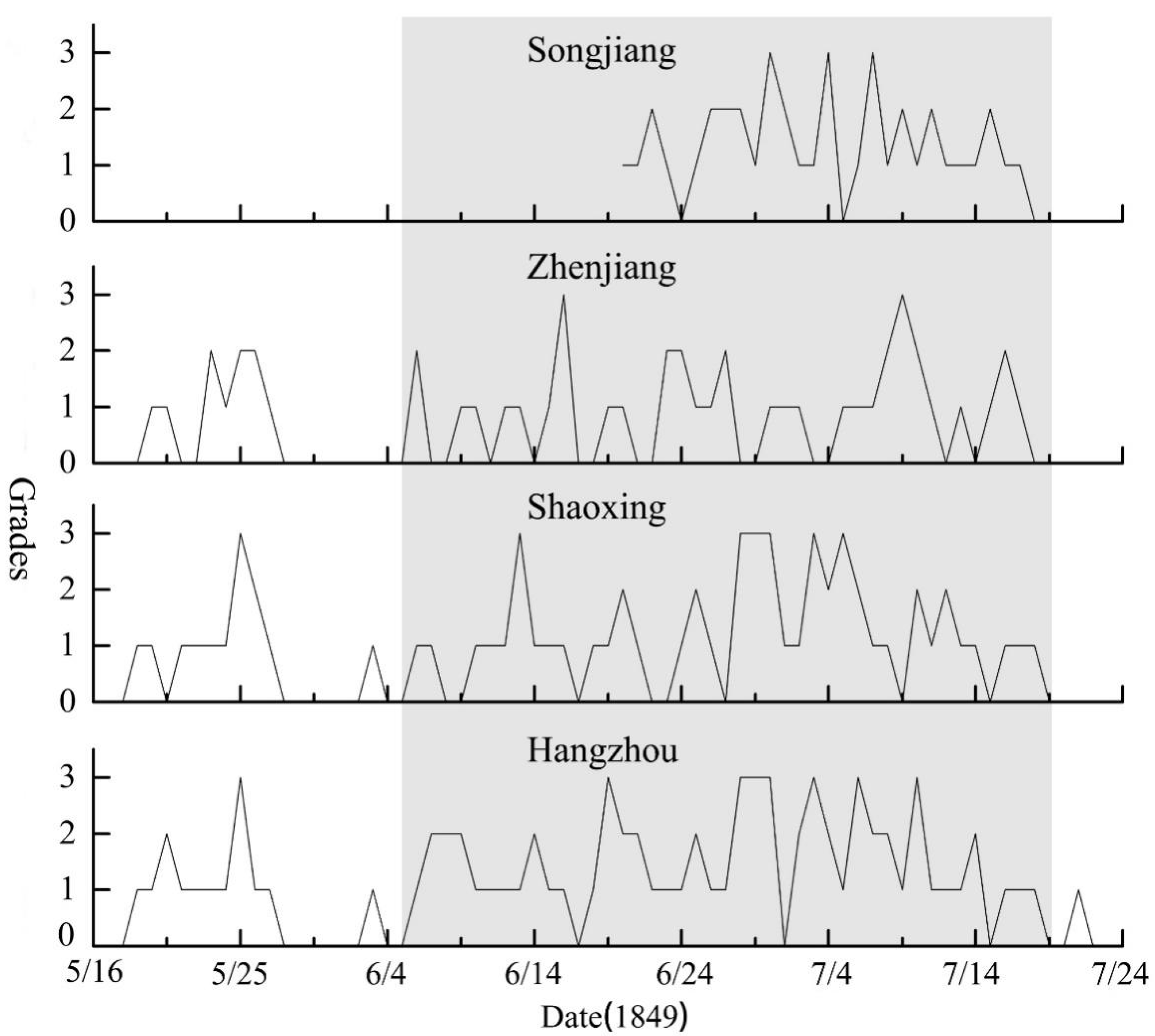
3.1. Reconstruction of the Temporal and Spatial Process of Summer Precipitation in 1849

In June–July 1848, Hubei, Hunan, Jiangxi, Anhui, Jiangsu, and Zhejiang Provinces were repeatedly affected by heavy rainfall. Specifically, Jiangsu and Zhejiang Provinces suffered from many typhoon events in July [41] (pp. 865–876). All these meteorological events caused severe floods at the middle and lower reaches of the Yangtze River, among which some did not dry up until the next spring.
In spring of the subsequent year, rainfall days still dominated in Hunan, Jiangxi, Anhui and Hubei Provinces, and floods were serious along the riverbank and in low-lying areas. According to a report by Zhao Bingyan (Governor of Hunan Province), the rivers and lakes of Hunan Province overflowed in about eight prefectures and counties in April-May, because of the abundant rain, resulting in submerged embankments and fields [41] (pp. 883–885). There were more than 5–10 rainfall events in Hubei Province in April–May [41] (p. 885). There were also numerous rainfall events in Anhui Province in spring, thus the water level rose much earlier than in common years [41] (p. 890). Fei Kaishou (Governor of Jiangxi Province) also reported plenty of rain in Jiangxi Province in late April, and the low-lying fields and levees along the river were flooded occasionally [41] (p. 881).
Since early summer, there were four consecutive heavy precipitation events at the middle and lower reaches of the Yangtze River, and there were several extreme precipitation centers in each event (Figure 2, and see more details in Appendix A, Table A1), which have plenty of historical records of heavy rainfall and severe flooding.
The first precipitation event occurred from 18 May to 30 May 1849, and extreme precipitation concentrated from 25 May to 28 May 1849. There was a center of extreme precipitation in the southeastern province of Hubei (30°–31° N, 112°–114° E). According to Zhao Bingyan’s memorial, from 25 May to 28 May 1849, heavy precipitation occurred in many places in Hubei, the water level in both Yangtze River and Han River rose simultaneously [41] (p. 885). At the same time, there was another extreme precipitation center in the middle of Jiangxi (26°30′–28°30′ N, 115°–117° E), where 14 prefectures and counties had much rain from 20 to 30 May 1849, according to the memorial of Fei Kaishou [41] (p. 885). There was a third center of extreme precipitation at the border of Hubei, Jiangxi, and Anhui (29°–30° N, 115°30′–116°30′ E). Apart from these, there was another east–west distributed center of extreme rainfall in the middle-eastern province of Anhui and southern province of Jiangsu (31°–32° N, 117°–121° E). There was extreme rainfall, “pouring down day and night”, in 11 prefectures and counties in Anhui Province, from 23 May to 27 May 1849, according to “The Transcript of Memorials from Ministry of Defense” [42] (p. 03-3502-073). A similar situation occurred in the Yangtze River Delta from 24 May to 27 May [41] (p. 891) [42] (p. 03-3576-006) [53,64] (p. 3961).
The second precipitation event occurred from 6 June to 18 June 1849, lasting for half a month. There was an extreme precipitation center in Southeastern Hubei (30°–31° N, 112°–115° E). According to the memorial of Tang Shuyi (Governor of Hubei), 14 prefectures and counties of Hubei Province experienced heavy rains from 11 June to 19 June 1849, where floodwaters rushed down from the mountains, and the lakes and rivers were rising [41] (p. 885). Meanwhile, there was a strip-type center of extreme precipitation in the central part of Jiangxi (26°30′–28°30′ N, 115°–117° E). Fei Kaishou reported heavy rains in many places in Jiangxi, from 11 June to 20 June 1849; the low-lying fields along the river were flooded and the dikes were washed down [41] (p. 885). From 11 June to 19 June 1849, there was another belt-shaped heavy precipitation center in the southern Anhui Province (30°–32° N, 117°–119° E), and the stagnant water could not be released in the low-lying fields of the counties in Anhui [41] (p. 890) [42] (p. 04-01-01-0836-013). There was also an extreme precipitation center at the junction of Hubei, Jiangxi, and Anhui (29°–30° N, 115°30′–116°30′ E). In addition, there was an extreme precipitation center in the southern province of Jiangsu and northern province of Zhejiang (29°–32° N, 119°–121° E), which was strip-like distributed from southwest to northeast. Fu Shengxun (Governor of Jiangsu) reported the heavy rains in Jiangsu Province, for days and nights from 12 June to 16 June 1849 [41] (p. 891), and continuous rainfall, with only half-day or moments of exceptions, in Zhejiang Province, from 10 June to 16 June 1849 [41] (p. 893) [51,52].
The third precipitation event occurred from 19 June to 30 June 1849, and the extreme precipitation center gradually moved westward. There was an extreme precipitation center in a southwest to northeast direction in the northern province of Hunan (28°–29°30′ N, 109°30′–113°30′ E). Zhao Bingyan reported that Hunan was flooded due to the rising lake water level and flash floods, and many embankments, fields, and houses were flooded in late June 1849 [41] (p. 893). There was also an extreme precipitation center in the southeastern province of Hubei, which was distributed in an east–west direction (30°–31° N, 112°–115° E). It poured for days in Hubei in late June 1849; hence, the Yangtze River, Han River, and many lakes rose and overflowed simultaneously [41] (p. 882). At the same time, there was a band-shaped extreme precipitation center in the northwestern province of Jiangxi and southern province of Anhui (28°40′–32° N, 115°–119° E). About 7 counties in Jiangxi and 14 counties in Anhui experienced heavy rain after 20 June 1849, and the water level of the Yangtze River was one meter above that in 1848 [41] (pp. 886–887) [42] (p. 04-01-01-0832-052). In addition, the Yangtze River Delta exhibited a strip-shaped extreme precipitation center from southwest to northeast (30°–32° N, 120°–121°30′ E), and many diaries recorded long-lasting rainfall in the Yangtze River Delta from 19 June to 30 June 1849 [51,52].
The fourth precipitation event took place from 1 July to 17 July 1849. The center of extreme precipitation was distributed more westward and northward, with the west border to the northeastern province of Guizhou, and the north border to Huai’an in Jiangsu (33°30′ N, 119° E). In the northeastern province of Guizhou and northwestern province of Hunan (27°–30° N, 109°–115° E), there was a large center of heavy rainfall distributed from southwest to northeast. In early and mid-July 1849, 11 counties in Guizhou and Hunan suffered from heavy rainfall [41] (p. 882) [42] (p. 04-01-01-0832-056). There was a center of extreme precipitation in central Hubei (30°–31° N, 111°–114° E). According to the memorial of Yutai (Governor of Huguang), the flood in Hubei had got no place to accommodate, overflowed the river bank, the rivers and lakes were connected just like seascapes” in early and mid-July 1849 [41] (p. 882). At the same time, there was another belt-shaped center of extreme rainfall in the northwestern province of Jiangxi, southern province of Anhui, and western province of Jiangsu, in a northwest–southwest direction (28°30′–32°30′ N, 115°–120° E). According to Wang Zhi’s report, more than 30 prefectures and counties had heavy rain and mountain torrents in mid-July 1849 in Anhui [41] (pp. 887, 891–892) [42] (p. 04-01-01-0832-052). Moreover, there was also a sub-center of extreme precipitation at the junction of Jiangsu, Zhejiang, and Anhui (28°30′–32° N, 118°–122° E). According to the memorial of Wu Wenrong, heavy rain hit 26 counties in Zhejiang, for days and nights, from 2 July to 14 July 1849, which increased the water levels of the rivers and broke the ditches [41] (p. 893). Heavy rain also occurred in Jiangsu from 5 July to 15 July 1849 [41] (p. 893) [65] (p. 11).
The heavy summer rainfall process in the Yangtze River Basin ended roughly around 20 July 1849 [41] (pp. 881–895) [42] (p. 04-01-01-0832-052) [65] (p. 11). After that, the middle and lower reaches of the Yangtze River entered into dry dog days (the hottest and driest period in a year, which occurs from mid-July to mid-August).

3.2. Reconstruction of the Yangtze River Flood Process in 1849

It was rainy in spring in Hunan, Hubei, Jiangxi, and Anhui, at the middle reaches of the Yangtze River, causing floods in low-lying areas. For example, the heavy precipitation in the northern province of Jiangxi caused rising river water levels and flooding in low-lying areas in late April 1849 [41] (p. 881). The dams were overwhelmed and the fields were flooded in the central province of Hunan [41] (p. 881). The heavy rainfall at the middle reaches was closely related to the flood at the middle and lower reaches of the Yangtze River [66], and would increase the water level of the mainstream simultaneously in the Yangtze River.
According to the memorial of Wang Zhi (Governor of Anhui), on 8 May 1849, “the Huaihe River had not returned to its normal storage capacity from the flood disaster last year (1848), more rain occurred since this spring, causing the water level to rise to the level almost three meters below the peak level last year” [41] (p. 890). Another memorial of Wang Zhi, on 2 August 1849, recorded that the peak water level in the summer of 1849 was one meter above the level in 1848 [41] (p. 896). According to the records of modern hydrological survey data, the peak water level in Anqing station (the provincial capital of Anhui) reached 18.14 m in 1849 (all water levels in our study are relative to the base level at Wusong), which was the highest water level recorded in history [55] (p. 399). Therefore, it can be conjectured that the peak water level of Anqing reached 17 m in 1848, and about 14 m on 8 May 1849. The latter was merely two meters below the current warning water level of 16.08 m at Anqing station [55] (p. 399).
With the occurrence of a stronger precipitation event at the middle reaches of the Yangtze River in late May 1849, the water level of the mainstream and main tributaries of the Yangtze River continued to rise. On 29 May 1849, lakes and rivers in central Hubei were flooded, and many dams were damaged [41] (p. 881). After the start of the Meiyu period on 6 June 1849, the Han River, Dongting Lake water system, and Poyang Lake water system entered flood season one after another, and the mainstream of the Yangtze River was facing tremendous flood pressure. According to the memorial of Tang Shuyi (Governor of Hubei), rivers and lakes in Hubei rose simultaneously, causing flooding in many places from 11 June to 19 July 1849 [41] (p. 885).
In early July 1849, the Yangtze River Basin was ushered in a new round of heavy precipitation, and floods continued to hit the middle reaches [41] (p. 885). Being blocked by the Yangtze River, the Poyang Lake in Jiangxi could not discharge. Hence, large-scale floods hit the entire watershed. In mid-to-late July 1849, with the arrival of the fourth round of extreme rainfall in summer, which was also the last round of heavy rainfall during the Meiyu period, flood peaks in many of the main tributaries of the Yangtze River (e.g., Hanjiang, Dongting Lake water system, and Poyang Lake water system) deluged into the mainstream simultaneously, resulting in the record high water levels at many hydrological stations in the middle reaches of the Yangtze River (as shown in Figure 3). The peak water level of Hankou in Hubei Province, at the middle reaches, reached 28.9 m [55] (p. 289). To prevent the water from flowing back to Wuhan city, the discharge gates had to be closed, causing seascape in the city, with ponding of around 1–4 m [41] (p. 882). Most of the residential areas were flooded in the city of Nanjing at the lower reaches. We speculate that the water level of the Yangtze River in Nanjing probably exceeded 10 m [67].
The water level of the mainstream of the Yangtze River remained high, due to flood water from the upstream and middle reaches after the Meiyu period. According to Tang Shuyi’s memorial on 30 August 1849, the water level of Wuhan city began to drop to about 3 m below the highest water level (i.e., a decline to about 26 m in late August). It was close to today’s warning water level of 26.3 m [41] (p. 887), but still higher than the preparation water level of 25 m [56] (p. 36). The water level in Nanjing dropped in probably around mid-September 1849, which was slower than Wuhan [67].
Figure 3a shows the peak water levels and maximum peak flow rates of some key stations at the middle and lower reaches of the Yangtze River in 1849 (see more details in Appendix A, Table A2). The maximum flow rate was mainly based on the peak water level/discharge curve of 1954 [56] (pp. 117–122). Among them, further explanation is needed on the peak flow rate of only 47,000 m3/s at Luoshan station (according to the peak water level/discharge curve in 1954). This might be related to the changes in the cross section of the riverbed, caused by the drastic changes in the middle reaches of the Yangtze River. The water level at Luoshan station was 31.4 m in 1849, which was the fourth highest water level in the history of Luoshan station. In 1954, the warning water level at Luoshan station was 31.5 m. Although the flood level in 1998 was 1.78 m higher than that in 1954, its peak water volume was 11,000 m3/s less than that in 1954. The change in the flood peak water volume at Luoshan station was related to the changes in the river near the new dam at the lower reaches of Luoshan. The mid-channel sand lands of this section of the river developed quickly since 1860, and developed into the mid-channel islands in 1934, which narrowed the cross section of the river [68] (p. 68). The flow cross section near Luoshan station was half as narrow as it was in 1849, causing backwater effect during the flood period and a high water level condition. By combining this factor with historical information, we speculate that the maximum flood peak was about 55,000 m3/s at Luoshan station in 1849.
Figure 3b shows the flood peak flow rates and water levels of the hydrological stations where the Yangtze River system reached the highest water level or flood flow rate in history, in 1849 (see more details in Appendix A, Table A2). The highest water level records in history appeared in hydrometric stations, from Yangluo station to Anqing at the middle reaches, and Yuxihe station downstream. The measurements of Wuhan and Wuxue stations in the middle reaches, and Datong and Nanjing stations downstream also nearly hit their highest water levels or peak flow rates in history. These demonstrate that the Yangtze River flood disaster broke out early, lasted for a long time, and the flood volume was extremely large, which was a rare extreme flood in history. At the same time, the river section with the highest water level or peak flow rate was mainly at the middle and lower reaches of the Yangtze River. The mainstream from Jingzhou to Chenglingji (also called the Jingjiang River) had the greatest flood prevention pressure in normal years (because of the curved channel), as it did not experience much flooding this year. This was related to the concentration of precipitation at the middle and lower reaches in summer in 1849. The flood from Luoshan station to Wuhan was obviously related to the water coming from the Dongting Lake system. The extreme high water levels in Wuxue and Yangluo could be related to the torrential rain in the northern tributaries, such as the Han River in July, and the backwater effect of Poyang Lake. The highest water level in history, in Anqing and Datong, probably appeared after 20 July 1849, which might be related to the flood coming from the Poyang Lake system.
The maximum peak flow rate in history, in the tributaries of the Yangtze River, was related to the extreme rainfall during the Meiyu period in July 1849. For example, the maximum peak flow rate of the Yuanjiang River might be related to the heavy rainfall in early July 1849 in the western province of Hunan and eastern province of Guizhou. Whilst the drainage area of the Youshui River in Baolong covered just less than 10,000 km2, the peak flow rate reached a remarkable amount of 13,100 m3/s.

4. Discussion

The amount of precipitation in the Yangtze River Basin in early summer is an important cause of the floods in the Yangtze River. The cause of the extreme flood in the Yangtze River in 1849 was unanimously believed to be the extremely long Meiyu period in early summer. The average length of the Meiyu period in East Asia is 26 days [69]. In our earlier study in 2008, we revealed that the Meiyu period in 1849 lasted 62 days, from 18 May to 18 July, which was the longest record in history [38]. Nevertheless, a study by Yan Chaoqiang suggested that the Meiyu period in 1849 lasted for 39 days (from 11 Jun to 19 July) [39]. In a subsequent study on the transition of the rain belt in Eastern China in 1849, however, Yan proposed that the heavy rainfall of 1849 started on 18 May [40]. The main reason for the divergences was that they were mainly based on the rain reports in the archives, whose resolution was too low to make clear judgments.
In this study, we utilized three weather diaries, with a higher resolution for Zhenjiang, Hangzhou, and Shaoxing at the lower reaches of the Yangtze River, apart from the weather diary in Songjiang, used by Yan Chaoqiang. By implementing the method of Zheng Weiwei on the data, we found that the Meiyu period of 1849 was from 6 June to 17 July, which lasted for 42 days and was 62% longer than the average length (Figure 4, and see more details in Appendix A, Table A3). Since the heavy rainfall period that began on 18 May was broken before 10 June, it was not classified as part of the Meiyu period (according to the definition criterion).
Many preliminary studies have investigated the types of summer precipitation in China [70,71,72]. The earlier Meiyu period at the middle and lower reaches of the Yangtze River reflects the strong subtropical high, while the long-time stagnation of the Meiyu belt in the Yangtze River Basin indicates the weak summer monsoon and unusually southerly subtropical high ridge. At the same time, the stagnation of the Meiyu rain belt in June and July indicates the blocking of high pressure in the mid-high latitudes of the Northern Hemisphere, the significance of the westerly wind branch, and the southerly distribution of the south branch of the westerly wind, compared to normal years [32,33]. In mid-to-late July, the blocking effect of the high pressure was lifted, the rain belt began to leap forward to North China, and heavy rainfall formed from the Haihe to Liaohe River Basins.
The reasons for the excessively long Meiyu period and strong precipitation in 1949 need to be further explored. Generally speaking, the extended period of stagnation of the Meiyu rain belt in the Yangtze River Basin indicates the weak summer monsoon and the unusually southerly location of the subtropical high ridge. The key driver of the long Meiyu period in 1998 was the strong El Niño event [32,33,34]. Nonetheless, there were no strong El Niño incidents in 1954 and 1849. In 1849, the temperature in East Asia was abnormal, the middle and lower reaches of the Yangtze River were rainy, and there were more low-temperature weather events in spring. According to Wu Wenrong’s memorial, “the temperature is low, so the flooded seedlings in the low field have been hopelessly damaged, the seedlings in high fields which have not been flooded are also difficult to grow” [26] (p. 894). At the same time, the cold air in North China was also very active, and frost and even snow events occurred in Shaanxi and Henan at the end of September and early October. All these indicate the relatively active cold air in 1849, the more developed blocking of high pressure in the mid–high latitudes of the Northern Hemisphere, and the blocked northward movement of the summer monsoon. In addition, the southwest monsoon was more active and the zonal airflow was strong in 1849. The rainy season in Yunnan started on 8 May, about 15 days earlier than normal [73]. A more active southwest monsoon brought more moisture and stronger zonal airflow. The study by Wang Zhiyi [74] suggested that the intensity of the zonal transport of moisture in the southwest had a significant correlation with the precipitation amount in the western region of Jianghuai during the Meiyu period.
Although the extreme flood was caused by the extremely long Meiyu period (as shown in Table 2), similarly to two other great floods in the Yangtze River (1954, 1998), since the instrumental records became available, they showed different characteristics in terms of the spatial pattern of precipitation and flood peaks. Figure 5 displays the summer rainfall conditions of China in 1849, 1931, 1954, and 1998. The figure shows that the precipitation was generally higher in the whole Yangtze River Basin in 1954 and 1998, yet mainly concentrated in the middle and lower reaches in 1849. The nationwide flood year occurred in 1931, when the entire Jianghuai region and the Yellow River Basin received more precipitation, but the flood peaks of the Yangtze River in 1931 were weaker than 1849, as shown in the flood survey data [55]. Apparently, the precipitation center was distributed more northerly in 1931.
There were three precipitation patterns in the four years of 1849, 1931, 1954, and 1998. The influence of different precipitation patterns on the Yangtze River flood peak can be discussed further. The inflow from the upstream basin above Yichang accounted for 54% of the Yangtze River’s flow from May to October in normal years [26] (pp. 6–7), so the inflow from the upstream reaches had a huge impact on the flood peaks in the middle and lower reaches. According to Table 3, the inflow of water above Yichang in 1849 was less than those in 1954 and 1998. Therefore, the floods in the Jingjiang section (where the flood control pressure was the heaviest) were less severe. However, the Yangtze River mainstream from Yangluo station to Poyang and Hukou showed the highest water level in history (Figure 3), which exceeded the great floods of 1954 and 1998. The flood peaks of hydrological stations such as Jiujiang and Datong in 1849 were slightly lower than those in 1954 and 1998, probably due to the flood diversion effect of a large number of dams in the middle reaches of the mainstream and tributaries at that time. There were numerous flooded areas in the middle reaches (i.e., 56 out of all 59 counties in Anhui, 33 out of 68 counties in Hubei, 39 out of 76 counties in Hunan, and 25 out of 79 counties in Jiangxi) [38]. Despite the significantly less inflow from the reach above Yichang in 1849, relative to 1954 and 1998, the runoff caused by extreme rainstorms in the middle reaches was significantly greater. The flood caused by extreme rainfall in the middle reaches of the Yangtze River requires more attention.
Since 1849, the Jingjiang section of the middle reaches of the Yangtze River (where the flood control pressure was the heaviest) rushed south and formed the Ouchi River. It also rushed south and formed the Songzi River in 1860, in the upstream river, for the Yangtze River to flood into the Dongting Lake [77] (pp. 196–298). Taking the year 1954 as an example, the peak flow rate of the Ouchi River diversion reached 14,800 m3/s, and the peak flow rate of Songzi River reached 10,140 m3/s. These accounted for 37.3% of the discharge of incoming water above Yichang [78]. In 2006, the Three Gorges Reservoir on the Yangtze River started to operate, with a flood control capacity of 221.5 × 10⁸ m3. This played an important role in regulating the flood peak from upstream. In 2020, the maximum inflow peak from upstream to the Three Gorges Reservoir reached 75,000 m3/s, and the outflow from the reservoir was only 49,200 m3/s. With a peak cut of 34.4%, it effectively relieved the downstream flood pressure [79]. It also relieved the flood control pressure from Yichang to Luoshan station, to a certain extent.
However, the flood control pressure brought by heavy rains at the middle and lower reaches, similar to that in 1849, should not be underestimated. The reservoir capacity of embankment systems at the middle and lower reaches of the Yangtze River have been greatly improved, compared to those in 1954 and 1998. For example, the safety guarantee water levels at Anqing station and Datong station were raised to 19.34 m and 17.10 m, respectively, i.e., much higher than the flood level in 1954 [45] (p. 459). In recent years, the flood diversion capacity of lakes and wetlands along the mainstream of the Yangtze River (e.g., Dongting Lake and Poyang Lake) has gradually weakened. The area of Dongting Lake dropped by 1725 km2 from 1949 to 1995, and the volume decreased by 126 × 108 m3, accordingly [80]. At the same time, with the socioeconomic development at the middle and lower reaches of the Yangtze River, the cost of using wetlands to divert floods is increasing. Therefore, the flood disaster type of the Yangtze River, caused by extreme precipitation at the middle reaches, similar to that in 1849, would result in a significant loss of life and property, and requires more attention.
Due to some ambiguity in historical documents, the spatial extent and time course of precipitation events were not clearly recorded. Also, the survey data in historical periods might not be equivalent to the measured data in modern times. The reconstruction methods of precipitation and flood processes in historical periods would inevitably contain some uncertainties. As for our study, the reconstruction of the spatial extent of extreme precipitation might bring uncertainty, due to the incomplete historical documentation and limited information on the flood process in the Yangtze River (only contained the flood peak height for the main hydrological stations). However, given the various sources of historical documents and survey data in 1849, the uncertainty of our reconstruction work should be restricted to some specific quantitative estimates, which should have little influence on our qualitative judgment about the characteristics of precipitation and flood processes.

5. Conclusions

Based on archives, diaries, and historical flood survey data, this study reconstructed the temporal and spatial patterns of precipitation and hydrological processes of the great flood disaster in the Yangtze River Basin in 1849.
In 1849, precipitation started earlier than in normal years, with four obvious precipitation events since May. The Meiyu period lasted for 43 days, and there was more precipitation.
The precipitation showed a typical belt-like distribution in the Yangtze River Basin in 1849. There were at least two precipitation centers, concentrated separately at the Taihu Lake Basin in the east, and from the eastern province of Hubei to midwestern province of Hunan in the west. Especially, the precipitation center in the west had a huge impact on the Yangtze River flood in the same year.
The cold air was active in the spring and early summer of 1849, and the southeast monsoon was weak. These caused the rain belt to stagnate in the Yangtze River Basin, for a long time. The onset of the southwest monsoon was earlier and more active, which supplied abundant moisture to the Yangtze River Basin. These were the meteorological causes for the flood disaster in 1849.
The Yangtze River flood season in 1849 started earlier and lasted longer than normal years. It entered the flood season in April, and the flood did not retreat until mid-September. Some stations along the mainstream in the middle reaches reached their highest water levels in history. The flood peak was primarily caused by extreme precipitation at the middle reaches. At present, the water conservancy projects on the Yangtze River are mainly built for floods caused by heavy rains in the upper reaches. In the future, the risk of floods in the Yangtze River would increase with the increase in extreme precipitation and the influences of human activities. Therefore, the pattern of precipitation in the middle reaches of the Yangtze River should receive greater attention in future flood control.

Author Contributions

Conceptualization, Y.Y., methodology, Y.Y., formal analysis, Y.Y. and Z.X., investigation, Z.X., data curation, Z.X., W.Z. and Y.K., writing—original draft preparation, Y.Y. and Z.X., writing—review and editing, Y.Y., Z.X. and Y.K., visualization, S.W., supervision, Y.Y., project administration, Y.Y. All authors have read and agreed to the published version of the manuscript.

Funding

This research was funded by grants from the National Key R&D Program of China, grant number 2018YFA0605601.

Conflicts of Interest

The authors declare no conflict of interest.

Appendix A

Table A1. The extreme precipitation sites of Meiyu period in 1849.
Precipitation EventsExtreme Precipitation SiteLongitude (E)Latitude (N)
The first precipitation eventMianyang113.230.3
Xiantao113.230.3
Qianjiang112.530.26
An’qing115.7629.78
Huangmei115.9330.09
Wuhu118.3331.33
Tongling117.8230.93
Fanchang118.2131.07
Tongcheng116.9431.04
Wuwei117.7531.3
Hexian118.3731.7
Xingzi116.0329.47
Wannian117.0828.7
Dehua115.9729.71
Jianchang116.6227.56
De’an115.7529.33
Ruichang115.6529.68
Qingjiang115.5428.07
Taihe114.8826.81
Zhenjiang119.4532.2
Suzhou120.6231.32
Changshu120.7431.64
Wuchang114.2930.569
Nanchang115.89828.682
Jiangning118.7732.05
Suzhou120.6231.32
Songjiang121.4731.25
The second precipitation eventHanyang114.0230.57
Jingmen112.231.04
Xiaogan113.9131
Hanchuan113.5930.63
Huanggang114.8730.44
Huangmei115.9330.09
Guangji115.5629.85
Jiayu113.9129.97
Jiangling112.1830.35
Huangpi114.3630.88
Qianjiang112.530.26
Pengze116.5629.9
Ruichang115.6529.68
Hukou116.2329.75
Hexian118.3731.7
Xingzi116.0329.47
Wannian117.0828.7
Dehua115.9729.71
Jianchang116.6227.56
De’an115.7529.33
Ruichang115.6529.68
Qingjiang115.5428.07
Taihe114.8826.81
An’qing115.7629.78
Wuhu118.3331.33
Wuwei117.7531.3
Tongling117.8230.93
Taiping118.1330.28
Fanchang118.2131.07
Tongcheng116.9431.04
Changshu120.7431.64
Zhenjiang119.4532.2
Shaoxing120.530
Huzhou120.130.86
Jiaxing120.7630.77
Yanzhou119.2729.49
Wuchang114.2930.569
Nanchang115.89828.682
Hangzhou120.1630.27
Jiangning118.7732.05
The third precipitation eventHanyang114.0230.57
Jingmen112.231.04
Jingzhou112.130.35
Qianjiang112.530.26
Huangmei115.9330.09
An’lu113.6931.25
Huanggang114.8730.44
Jiujiang115.9729.71
Pengze116.5629.9
Hukou116.2329.75
Ruichang115.6529.68
Shangrao117.9728.47
De’an115.7529.33
Ganzhou114.9225.85
Xiangyin112.8728.68
Yuanjiang112.3628.83
Yiyang112.3328.6
Taoyuan111.4728.9
Linxiang113.4229.48
Baling113.0929.37
An’xiang112.1629.41
Fenghuang109.4327.92
Yuanling110.3928.46
Yongsui109.4628.59
Jishou109.7128.3
Wuhu118.3331.33
Wuwei117.7531.3
Tongling117.8230.93
An’qing115.7629.78
Hanshan118.1131.7
Dangtu118.4931.55
Fanchang118.2131.07
Taiping118.1330.28
Huaining116.6330.41
Susong116.1330.15
Wangjiang116.6930.12
Tongcheng116.9431.04
Lujiang117.2931.23
Taihu116.2730.42
Guichi117.4830.66
Changshu120.7431.64
Shaoxing120.530
Haining120.6930.53
Zhenjiang119.4532.2
Suzhou120.6231.32
Wuchang114.2930.569
Changsha112.9828.2
Nanchang115.89828.682
Hangzhou120.1630.27
The fourth precipitation eventXianning114.2829.87
Huangmei115.9330.09
Puqi113.8529.71
Zhongxiang112.5831.17
Yingcheng113.630.94
Yunmeng113.7331.02
Jianli112.929.83
Shishou112.4129.73
Tongshan114.5229.6
Yangxin115.2229.83
Jingzhou112.130.35
An’xiang112.1629.41
Fenghuang109.4327.92
Yuanling110.3928.46
Xiangyin112.8728.68
Yuanjiang112.3628.83
Yiyang112.3328.6
Baling113.0929.37
Yongsui109.4628.59
Jishou109.7128.3
Taoyuan111.4728.9
Linxiang113.4229.48
Jiujiang115.9729.71
Pengze116.5629.9
Hukou116.2329.75
Ruichang115.6529.68
Shangrao117.9728.47
De’an115.7529.33
Ganzhou114.9225.85
Lujiang117.2931.23
Susong116.1330.15
Taiping118.1330.28
Wuhu118.3331.33
Wuwei117.7531.3
Tongling117.8230.93
An’qing115.7629.78
Hanshan118.1131.7
Dangtu118.4931.55
Fanchang118.2131.07
Huaining116.6330.41
Wangjiang116.6930.12
Tongcheng116.9431.04
Taihu116.2730.42
Guichi117.4830.66
Jianping119.1731.14
Qianshan116.5330.62
Shexian 118.4429.88
Xiuning118.1929.81
Qimen117.729.86
Jixi118.5730.07
Nanling118.3230.91
Xuancheng118.7331.95
Qingyang117.8430.64
Taixian117.4830.19
Chaoxian117.8731.62
Yixian117.9229.93
Jingde118.5330.28
Shucheng116.9431.45
Chuzhou118.3132.33
Laian118.4432.44
Quanjiao118.2732.1
Guangde119.4130.89
Zhenjiang119.4532.2
Suzhou120.6231.32
Changshu120.7431.64
Huai’an119.02233.63
Taicang121.131.45
Yangzhou119.4232.39
Shaoxing120.530
Huzhou120.130.86
Jiaxing120.7630.77
Yanzhou119.2729.49
Haining120.6930.53
Fuyang119.9530.07
Yuhang120.330.43
Jiashan120.9230.84
Haiyan120.9230.53
Tongxian120.5430.64
Deqing120.0830.54
Changxing119.9130.01
Yuyao121.1630.04
Chunan119.0529.61
Tonglu119.6429.8
Tongren109.2127.73
Songtao109.1828.17
Wuchang114.2930.569
Nanchang115.89828.682
Hangzhou120.1630.27
Changsha112.9828.2
Table A2. The records of water levels and flood peak flow rates of the Yangtze River in 1849 from “The Compilation of Survey Data of Historical Great Floods in China” [55].
Yangtze RiverHydrological StationLocationWater Level (m)Flood Peak Flow Rate (m3/s)Degree of CredibilityOrgan of SurveyRemarks
Main stream of Yangtze
River
LuoshanHonghu, Hubei31.4047,000highChangjiang Water Resources Committee /
XindiHonghu, Hubei30.98/highChangjiang Water Resources Committee/
JiayuJiayu,
Hubei
30.47/highChangjiang Water Resources CommitteeThe water level of Jiayu was 31.47 m in 1954
JinkouJinkou,
Wuchang
30.05/highChangjiang Water Resources CommitteeThe water level of Jinkou was 30.78 m in 1954
Wuhanguan of HankouHankou,
Wuhan
28.9065,000highChangjiang Water Resources CommitteeThe water level of Hankou was 26.91 m in 1949, and the catchment area was 1,488,036 km2
LuoyangLuoyang,
Xinzhou
28.61/highChangjiang Water Resources CommitteeThe highest water level on records
EchengEcheng27/highChangjiang Water Resources CommitteeThe highest water level on records
HuangshiHuangshigang,
Huangshi
25.8/highChangjiang Water Resources CommitteeThe highest water level on records
WuxueWuxue,
Guangji
22.6662,500highChangjiang Water Resources CommitteeThe highest water level on records
HukouHukou,
Jiangxi
21.16/highChangjiang Water Resources CommitteeThe water level of Hukou was 21.64 m in 1954
DongliuDongliu19.45/highChangjiang Water Resources CommitteeThe highest water level on records, and water level was 18.28 m in 1949, which was the second highest water level on records.
AnqingAnqing18.14/highChangjiang Water Resources CommitteeThe highest water level on records, and water level was 17.27 m in 1949, which was the second highest water level on records.
ZongyangZongyang town, Zongyang16.96/highChangjiang Water Resources CommitteeThe highest water level on records, and water level was 15.84 m in 1949, which was the second highest water level on records.
DatongMeigeng town,
Guichi
16.1480,000highChangjiang Water Resources CommitteeThe highest water level on records, and water level was 15.18 m in 1949, which was the second highest water level on records, and the catchment area was 1,705,383 km2.
Branches of Yangtze RiverYinjiangEling town,
Yinjiang
//highWater Resources Department
of Guizhou
The highest water level on records
BayanxiongChangyan town, Huangbei/>1480 Water Resources Department
of Hubei
The second highest water level on records, and flood peak was 1480 m3/s, which was the third largest flood peak on records.
MachengXujia town,
Macheng
/>3530/Water Resources Departmentof HubeiThe highest water level on records
LuotianChengguan town, Luotian/2650for reference onlyWater Resources Departmentof HubeiThe highest water level in history, and the largest flood peak on records was 4240 m3/s on 14 July 1969
YujiapuLiujia he, Jichun/5330for reference onlyWater Resources Departmentof HubeiThe largest flood peak on records.
YangaxinFushui town,
Yangxin
/6100for reference onlyWater Resources Departmentof HubeiThe highest water level in history, and the largest flood peak on records was 3910 m3/s on 17 June 1959.
FenghuangTuojiang town, Fenghuang/1800–1960/Water Resources Departmentof HunanThe second largest flood peak in history, and the largest flood peak was 11,100 m3/s on 30 June 1974.
LongtouLongtou town, Baojing/>13,100/Water Resources Departmentof HunanThe largest flood peak in history, and the second largest flood peak on records was 13,100 m3/s in 1927.
BaojingQianling town,
Baojing
/13,700highWater Resources Departmentof HunanThe fifth largest flood peak in history, and the largest flood peak was 11,100 m3/s on 29 June 1954.
ChenjiaheChenjiahe,
Zhangjiajie
/>9000/Water Resources Departmentof HunanThe largest flood peak in history, and the third largest flood peak on records was 9000 m3/s on 5 July 1935.
ChaoxianChaoxian13.57/for reference onlyWater Resources Departmentof AnhuiThe highest water level on records, and the water level was 13.09 m in 1954.
TaoxiTaoxi town, Shucheng/573for reference onlyWater Resources Departmentof AnhuThe forth largest flood peak on records, and the largest flood peak was 1250 m3/s on 12 July 1991.
KaichengqiaoKaichengq-iao town, Wuwei///Water Resources Departmentof AnhuThe largest flood peak in history.
Note: the water level was relative to the base level at Wusong.
Table A3. The precipitations recorded by diaries in 1849.
The Lunar CalendarThe Gregorian CalendarGuantingfen’s Diary (Hanghzou)Sanyuantang’s Diary (Zhenjiang)Pinglu’s Diary (Shaoxing)Flood Diary in Ji Yu (Shanghai)
MonthDayMonthDayWeather ConditionGradeWeather ConditionGradeWeather ConditionGradeWeather ConditionGrade
424516sunny0sunny0sunny0//
425517sunny0sunny0sunny0//
426518light rain1sunny0light rain1//
427519light rain1light rain1light rain1//
428520moderate rain2light rain1sunny0//
429521light rain1sunny0light rain1//
430522light rain1sunny0light rain1//
51523light rain1moderate rain2light rain1//
52524light rain1light rain1light rain1//
53525rainstrom3moderate rain2rainstrom3//
54526light rain1moderate rain2moderate rain2//
55527light rain1light rain1light rain1//
56528sunny0sunny0rainstrom3//
57529sunny0sunny0sunny0//
58530sunny0sunny0sunny0//
59531sunny0sunny0sunny0//
51061sunny0sunny0sunny0//
51162sunny0sunny0sunny0//
51263light rain1sunny0light rain1//
51364sunny0sunny0sunny0//
51465sunny0sunny0sunny0//
51566light rain1moderate rain2light rain1//
51667moderate rain2light rain1light rain1//
51768moderate rain2sunny0sunny0//
51869moderate rain2light rain1sunny0//
519610light rain1light rain1light rain1//
520611light rain1sunny0light rain1//
521612light rain1light rain1light rain1//
522613light rain1light rain1rainstrom3//
523614moderate rain2sunny0light rain1//
524615light rain1light rain1light rain1//
525616light rain1rainstrom3light rain1//
526617sunny0sunny0sunny0//
527618light rain1sunny0light rain1//
528619rainstrom3light rain1light rain1//
529620moderate rain2light rain1moderate rain2light rain1
530621moderate rain2sunny0light rain1light rain1
61622light rain1sunny0sunny0moderate rain2
62623light rain1moderate rain2sunny0light rain1
63624light rain1moderate rain2light rain1light rain1
64625moderate rain2light rain1rainstrom3sunny0
65626light rain1light rain1light rain1moderate rain2
66627light rain1moderate rain2sunny0moderate rain2
67628rainstrom3sunny0rainstrom3moderate rain2
68629rainstrom3sunny0rainstrom3light rain1
69630rainstrom3light rain1rainstrom3rainstrom3
61071sunny0light rain1light rain1moderate rain2
61172moderate rain2light rain1light rain1light rain1
61273rainstrom3sunny0rainstrom3light rain1
61374moderate rain2sunny0moderate rain2rainstrom3
61475light rain1light rain1rainstrom3sunny0
61576rainstrom3light rain1moderate rain2light rain1
61677moderate rain2light rain1light rain1rainstrom3
61778moderate rain2moderate rain2light rain1light rain1
61879light rain1rainstrom3sunny0moderate rain2
619710rainstrom3moderate rain2moderate rain2light rain1
620711light rain1sunny0light rain1moderate rain2
621712light rain1light rain1moderate rain2light rain1
622713light rain1sunny0light rain1light rain1
623714moderate rain2light rain1light rain1light rain1
624715sunny0light rain1sunny0moderate rain2
625716light rain1moderate rain2light rain1light rain1
626717light rain1sunny0light rain1light rain1
627718light rain1sunny0light rain1sunny0
628719sunny0sunny0sunny0sunny0
629720sunny0sunny0sunny0sunny0
630721light rain1sunny0sunny0sunny0
71722sunny0sunny0sunny0sunny0
72723sunny0sunny0sunny0sunny0
73724sunny0sunny0sunny0sunny0
74725sunny0sunny0sunny0sunny0
75726sunny0sunny0sunny0sunny0
76727sunny0sunny0sunny0sunny0
77728sunny0sunny0sunny0sunny0
78729sunny0light rain1sunny0sunny0
79730sunny0light rain1sunny0sunny0
710731sunny0sunny0light rain1sunny0

References

  1. Freer, J.; Beven, K.J.; Neal, J.; Schumann, G.; Hall, J.; Bates, P. Risk and Uncertainty Assessment for Natural Hazards: Flood Risk and Uncertainty; Cambridge University Press: Cambridge, UK, 2011; pp. 190–233. [Google Scholar]
  2. Alexander, L.; Zhang, X.; Hegerl, G.; Seneviratne, S. Implementation Plan for WCRP Grand Challenge on Understanding and Predicting Weather and Climate Extremes 2015. Available online: https://www.wcrp-climate.org/images/documents/grand_challenges/GC_Extremes_v2.pdf (accessed on 4 June 2021).
  3. John, P. A Regional Perspective of the Hydrology of the 1993 Mississippi River Basin Floods. Ann. Assoc. Am. Geogr. 1977, 87, 135–151. [Google Scholar] [CrossRef]
  4. Yuna, M.; Zhou, T.; Ruby, L.; Teklu, K.; Tesfa, H.; Li, Y.; Wang, K.; Tan, Z.; Getirana, A. Flood Inundation Generation Mechanisms and Their Changes in 1953-2004 in Global Major River Basins. J. Geophys. Res. Atmos. 2019, 124, 11672–11692. [Google Scholar] [CrossRef]
  5. Alexander, L.V.; Zhang, X.; Peterson, T.C.; Caesar, J.; Gleason, B.; Klein Tank, A.M.G.; Haylock, M.; Collins, D.; Trewin, B.; Rahimzadeh, F.; et al. Global observed changes in daily climate extremes of temperature and precipitation. J. Geophys. Res. 2006, 111, D5. [Google Scholar] [CrossRef] [Green Version]
  6. Iracema Fonseca Albuquerque Cavalcanti. Large scale and synoptic features associated with extreme precipitation over South America: A review and case studies for the first decade of the 21st century. Atmos. Res. 2012, 118, 27–40. [Google Scholar] [CrossRef]
  7. Cavalcanti, I.F.A.; Carril, A.F.; Penalba, C.; Grimm, A.M.; Menendez, C.G.; Sanchez, E.; Cherchi, A.; Soerensson, A.; Robledo, F.; Rivera, J.; et al. Precipitation extremes over La Plata Basin—Review and new results from observations and climate simulations. J. Hydrol. 2015, 523, 211–230. [Google Scholar] [CrossRef]
  8. Dayan, U.; Nissen, K.; Ulbrich, U. Review Article: Atmospheric conditions inducing extreme precipitation over the eastern and western Mediterranean. Nat. Hazards Earth Syst. Sci. 2015, 15, 2525–2544. [Google Scholar] [CrossRef] [Green Version]
  9. Barlow, M.; Gutowski, W.J.; Gyakum, J.R.; Katz, R.W.; Min, S.K. North american extreme precipitation events and related large-scale meteorological patterns: A review of statistical methods, dynamics, modeling, and trends. Clim. Dyn. 2019, 53, 6835–6875. [Google Scholar] [CrossRef] [Green Version]
  10. IPCC. Summary for Policymakers. In Climate Change 2021: The Physical Science Basis. Contribution of Working Group I to the Sixth Assessment Report of the Intergovernmental Panel on Climate Change; Masson-Delmotte, V., Zhai, P., Pirani, A., Connors, S.L., Péan, C., Berger, S., Caud, N., Chen, Y., Goldfarb, L., Gomis, M.I., et al., Eds.; Cambridge University Press: Cambridge, UK, in press.
  11. Suppiah, R.; Hennessy, K. Trends in seasonal rainfall, heavy rain days, and number of dry days in Australia 1910–1990. Int. J. Climatol. 1998, 18, 1141–1155. [Google Scholar] [CrossRef]
  12. Iwashima, T.; Yamamoto, R.; Sakurai, Y. Long-term trends of extremely heavy precipitation intensity in Japan in recent 100 years. Rec. Res. Devel Meteorol. 2002, 1, 1–9. Available online: http://www.hyarc.nagoya-u.ac.jp/game/6thconf/html/abs_html/pdfs/T2NY09Aug04133300.pdf (accessed on 4 June 2021).
  13. Madsen, H.; Lawrence, D.; Lang, M.; Martinkova, M.; Kjeldsen, T.R. Review of trend analysis and climate change projections of extreme precipitation and floods in Europe. J. Hydrol. 2014, 519, 3634–3650. [Google Scholar] [CrossRef] [Green Version]
  14. Dahe, Q. China’s National Assessment Report on Extreme Climate Events and Disaster Risk Management and Adaptation; Science Press: Beijing, China, 2015; pp. 5–14. [Google Scholar]
  15. Kunkel, K.; Changnon, S.; Angel, J. Climatic aspects of the 1993 upper Mississippi River basin flood. Bull. Am. Meteorol. Seciety 1994, 75, 811–822. [Google Scholar] [CrossRef] [Green Version]
  16. Merino, A.; Fernández-González, S.; García-Ortega, E.; Sánchez, J.L.; López, L.; Gascón, E. Temporal continuity of extreme precipitation events using sub-daily precipitation: Application to floods in the ebro basin, northeastern spain. Int. J. Climatol. 2018, 38, 1877–1892. [Google Scholar] [CrossRef]
  17. Lukić, T.; Lukić, A.; Basarin, B.; Ponjiger, T.M.; Blagojević, D.; Mesaroš, M.; Milanović, M.; Gavrilov, M.; Pavić, D.; Zorn, M.; et al. Rainfall erosivity and extreme precipitation in the pannonian basin. Open Geosci. 2019, 11, 664–681. [Google Scholar] [CrossRef]
  18. Yigzaw, W.; Hossain, F.; Kalyanapu, A. Impact of artificial reservoir size and land use/land cover patterns on probable maximum precipitation and flood: Case of folsom dam on the american river. J. Hydrol. Eng. 2012, 18, 1180–1190. [Google Scholar] [CrossRef]
  19. Giuseppe, S.; Flavia, F.; Silvia, L.; Francesco, M.; Filippi, D. A method to contrast the impact of extreme precipitation: A case study from central italy. IOP Conf. Ser. Mater. Sci. Eng. 2019, 471, 1–7. [Google Scholar] [CrossRef]
  20. Chang, H.; Eom, S.; Makido, Y.; Bae, D.H. Land use change, extreme precipitation events, and flood damage in south korea: A spatial approach. J. Extrem. Events 2020, 7, 23. [Google Scholar] [CrossRef]
  21. Herget, J.; Kapala, A.; Krell, M.; Rustemeier, E.; Wyss, A. The millennium flood of July 1342 revisited. Catena 2015, 130, 82–94. [Google Scholar] [CrossRef]
  22. Elleder, L. Reconstruction of the 1784 flood hydrograph for the Vltava River in Prague Czech Republic. Glob. Planet. Chang. 2010, 70, 117–124. [Google Scholar] [CrossRef]
  23. McEwen, L.J.; Werritty, A. The Muckle Spate of 1829: The physical and societal impact of a catastrophic flood on the River Findhorn, Scottish Highlands. Trans. Inst. Br. Geogr. 2007, 32, 66–89. [Google Scholar] [CrossRef]
  24. Brazdil, R.; Demaree, G.R.; Deutsch, M.; Garnier, E.; Kiss, A.; Luterbacher, J.; Macdonald, N.; Rohr, C.; Dobrovolný, P.; Kolář, P.; et al. European floods during the winter 1783/1784: Scenarios of an extreme event during the ‘Little Ice Age’. Theor. Appl. Climatol. 2010, 100, 163–189. [Google Scholar] [CrossRef]
  25. Rössler, O.; Brönnimann, S. The effect of the Tambora eruption on Swiss flood generation in 1816/1817. Sci. Total Environ. 2018, 627, 1218–1227. [Google Scholar] [CrossRef]
  26. Ministry of Water Resources. The Records of Yangtze River: River System; Encyclopedia of China Publishing House: Beijing, China, 2003. [Google Scholar]
  27. Yijie, M. Minreal Compositions and Fritility of Soils in Middle and Lower Reaches of the Yangtze River. Resour. Environ. Yangtze River 1994, 3, 1–8. [Google Scholar]
  28. Zhen, Y.; Qiyan, D.; Qingyu, Z.; Huimin, L. Differentiation pattern of population health and its geographical influencing factors in the middle-lower reaches of the Yangtze River. Geogr. Geo-Inf. Sci. 2018, 34, 77–84+2. [Google Scholar] [CrossRef]
  29. Gang, Z.; Xiang, K. Preliminary study on the causes and counter measures of the 1954 and 1998 extraordinary Yangtze River floods. J. Catastrophol. 1999, 14, 23–27. [Google Scholar] [CrossRef]
  30. Hanyao, C. Circulation characteristics of the Yangtze River and Huaihe River basin during flood in 1954. Acta Meteorol. Sin. 1957, 1, 1–12. [Google Scholar] [CrossRef]
  31. Jinrong, C.; Zhongshu, H. Extreme rain and flood in the Yangtze River basin in 1954. Hydrology 1986, 01, 56–62+15. [Google Scholar] [CrossRef]
  32. Siwei, Z.; Jianhua, S.; Hong, C.; Feng, Z. Analysis of rainstorm characteristics during the heavy flood in The Yangtze River Basin in July 1998. Clim. Environ. Res. 1998, 4, 81–94. [Google Scholar] [CrossRef]
  33. Shuyi, C.; Yuean, L. Comparative analysis of summer large-scale circulation characteristics in 1998 and 1954. Meteorol. Mon. 2000, 1, 38–42. [Google Scholar] [CrossRef]
  34. Ming, F.; Baojia, W.; Shouquan, X. Analysis on the abnormality of general circulation and sea temperature in relation to the flood water of Yangtze River in 1998. Resour. Environ. Yangtze Basin 2000, 9, 113–118. [Google Scholar] [CrossRef]
  35. Kai, W. The characteristics and the warnings of the flood in the Yangtze River in 1998. Prog. Geogr. 1999, 18, 22–27. [Google Scholar] [CrossRef]
  36. Huixia, Z.; Jingyun, Z.; Quansheng, G. The reconstruction of 1755 and 1849 severe flood events in Jiangsu and Anhui provinces. Sci. Meteorol. Sin. 2004, 24, 460–467. [Google Scholar] [CrossRef]
  37. Jingyun, Z.; Huixia, Z. Seasonal precipitation changes and extreme precipitation anomalies in Jiangsu during the middle and late Qing Dynasty. Geogr. Res. 2005, 24, 673–680. [Google Scholar]
  38. Yuda, Y.; Weiwei, Z. Spatio-temporal distribution and synoptic characteristics of the great flood in the middle and lower reaches of the Yangtze River in 1849. J. Palaeogeogr. 2008, 4, 657–664. [Google Scholar] [CrossRef]
  39. Chaoqiang, Y.; Xiuqi, F.; Yu, Y.; Xuzhen, Z. Reconstruction of plum rain season and its rainfall of Shanghai in 1849 based on Records of the Flood in 1849. J. Palaeoceography 2011, 13, 96–102. [Google Scholar] [CrossRef]
  40. Chaoqiang, Y.; Wenhui, X.; Yuling, M.; Yu, Y. Shifts of rain belts in eastern China and floods of the Yangtze River basin in 1849. Quat. Sci. 2012, 32, 318–326. [Google Scholar] [CrossRef]
  41. Department of Water Resources Management; Department of Science; Technology of Ministry of Water Resources; Hydroelectric Power of the PRC. Records of Floods of the Yangtze River Basin and the International Rivers in Southwest in the Qing Dynasty; Zhonghua Book Company: Beijing, China, 1991. [Google Scholar]
  42. The Transcript of Memorials from Ministry of Defense; China’s First Historical Archives: Beijing, China, Qing Dynasty.
  43. China’s First Historical Archives. Collected Grand Edicts in the Daoguang Reign of Qing Dynasty; Guangxi Normal University Press: Guilin, China, 2009. [Google Scholar]
  44. De’er, Z. A Compendium of Chinese Meteorological Records of the Last 3000 Years; Phoenix Press: Nanjing, China; Jiangsu Education Publishing House: Nanjing, China, 2004. [Google Scholar]
  45. Ministry of Water Resources. The Records of Yangtze River: Flood Control; Encyclopedia of China Publishing House: Beijing, China, 2003. [Google Scholar]
  46. Nanjing Local Chronicles Compilation Committee. The Water Conservancy Chronicle of Nanjing City; Haitian Publishing House: Shanghai, China, 1994. [Google Scholar]
  47. The Water Conservancy Chronicle Compilation Committee of Jiujiang City. The Water Conservancy Chronicle of Jiujiang City; Yanshan Publishing House: Beijing, China, 2001. [Google Scholar]
  48. The Water Resources Bureau of Anqing City. The Water Conservancy Chronicle of Anqing City; Anqing Local Chronicles Compilation Committee: Anqing, Beijing, 1990. [Google Scholar]
  49. Zhu, X.X. Climatic information from 1700-1703 A.D. in Weizhai Diary. J. Palaeogeogr. 2004, 6, 95–100. [Google Scholar] [CrossRef]
  50. Man, Z.M.; Li, Z.L.; Yang, Y.D. Characteristics of Meiyu during 1867-1872 in Wuhan and Changsha areas recorded in Wang Wenshao Diary. J. Palaeogeogr. 2007, 9, 431–438. [Google Scholar] [CrossRef]
  51. Guan, T. Guan Tingfen’s Diary; Zhonghua Book Company: Beijing, China, 2013. [Google Scholar]
  52. Ping Lu’s Diary; The Manuscript of Zhejiang Provincial Library: Hangzhou, China, Qing Dynasty.
  53. Zhao, Y. Sanyuantang’s Diary; The manuscript of Peking University Library: Beijing, China, Qing Dynasty. [Google Scholar]
  54. Yao, J. Flood Diary in Ji Yu. In Modern History Data: 30; Institute of Modern History in Chinese Academy of Social Sciences, ed.; Zhonghua Book Company: Beijing, China, 1963. [Google Scholar]
  55. Chengzheng, L. The Compilation of Survey Data of Historical Great Floods in China; China Bookstore: Beijing, China, 2006. [Google Scholar]
  56. Hydrological Bureau of Yangtze River Water Resources Commission. The Great Flood of 1954 in Yangtze River; Changjiang Publishing House: Wuhan, China, 2004. [Google Scholar]
  57. Gaofa, G. Methods of Studying Climate Change in Historical Periods; Science Press: Beijing, China, 1983. [Google Scholar]
  58. Herget, J.; Roggenkamp, T.; Krell, M. Estimation of peak discharges of historical floods. Hydrol. Earth Syst. Sci. Discuss. 2014, 11, 5463–5485. [Google Scholar] [CrossRef]
  59. Pwa, B.; Dla, B.; Jma, B.; Lei, G.B.; Jt, A. Reconstructing the man-made yellow river flood of kaifeng city in 1642 ad using documentary sources-science direct. Int. J. Disaster Risk Reduct. 2019, 41, 101289. [Google Scholar] [CrossRef]
  60. Weiwei, Z.; Yuda, Y.; Zhimin, M. Multiple movement characteristics of the Meiyu rain belt in East Asia: Reconstructing historical data on the southern margin from 1861 to 2017. Clim. Chang. 2021, 165, 1. [Google Scholar] [CrossRef]
  61. Academy of Meteorological Sciences in Central Meteorological Administration. The Atlas of Distribution Droughts and Floods in past 500 Years in China; Map Publishing House: Beijing, China, 1981. [Google Scholar]
  62. Yuda, Y.; Jianfu, H. Research on the Method of Discriminating Extreme Climate Events in Historical Period—Taking the Northwest Millennium Drought Sequence as an Example. Chin. Hist. Geogr. 2014, 4, 10–29. [Google Scholar]
  63. Deer, Z.; Chuanzhi, L. The Sequel Atlas of Distribution Droughts and Floods in past 500 years in China. Meteorology 1993, 19, 41–45. [Google Scholar] [CrossRef]
  64. Wenhai, L.; Mingfang, X.; Hu, Z. A collection of Chinese Famine Books: 6; Tianjin Ancient Books Publishing House: Tianjin, China, 2011. [Google Scholar]
  65. Longwei, Q.; Wang, L.; Ji, Y.Y. Lou Wang Yu Yu Ji; Zhonghua Book Company: Beijing, China, 1997. [Google Scholar]
  66. Dingzhen, Z.; Yushi, C.; Qinglou, W.; Zhen, Z.; Zengkui, Z. Prediction of rainfall and water level increase in the middle and lower reaches of Yangtze River during flood season. Sci. Meteorol. Sin. 2002, 4, 351–355. [Google Scholar] [CrossRef]
  67. Zhengrong, X.; Yuda, Y.; Tao, S. Feng Shui and Imperial Examinations: A case study on the 1849 severe flood in Nanjing and debates on flood discharge. Clim. Chang. 2021, 166, 56–65. [Google Scholar] [CrossRef]
  68. Xiugui, Z. Historical Geomorphology and Ancient Map Research of China; Social Sciences Academic Press: Beijing, China, 2006. [Google Scholar]
  69. Quansheng, G.; Xifeng, G.; Jingyun, Z.; Zhixin, H. Changes of meiyu in the middle and lower reaches of the Yangtze River since 1736. Sci. Bull. 2007, 23, 2792–2797. [Google Scholar] [CrossRef]
  70. Li, X.; Zhenguo, Z.; Yongguang, W. An objective classification method of summer (June–August) precipitation in eastern China. Sci. Bull. 2000, 20, 270–276. [Google Scholar] [CrossRef]
  71. Li, X.; Zhenguo, Z.; Linhai, S. Division of more (less) rain patterns and characteristics of environmental fields in China. J. Appl. Meteorol. Sci. 2005, B03, 77–84. [Google Scholar] [CrossRef]
  72. Shaowu, W.; Jinlin, Y.; Daoyi, G. Study on summer precipitation patterns in eastern China. J. Appl. Meteorol. Sci. 1998, 9, 67–74. [Google Scholar]
  73. Yuda, Y.; Zhimin, M.; Jingyun, Z. Reconstruction of Series in Later or Earlier of Rainy Season in Yunnan and Evolvement of Summer Monsoon during 1711–1982. J. Geogr. Sci. 2007, 17, 212–220. [Google Scholar] [CrossRef]
  74. Zhiyi, W.; Qingjiu, G.; Banghui, H.; Yuting, S. Characteristics of water vapor transport during Meiyu period in Recent 50 years in Jianghuai Region. Trans. Atmos. Sci. 2017, 40, 48–60. [Google Scholar] [CrossRef]
  75. Jingyun, Z.; Di, S.; Kebang, L.; Zhixin, H.; Xuezhen, Z.; Quansheng, G. Variations of Extreme Meiyu Events and Flood Disasters over the Mid-lower Reaches of theYangtze River in the Past 300Years. J. Nat. Resour. 2016, 12, 1971–1983. [Google Scholar] [CrossRef]
  76. National Climate Center. The Meiyu Data during 1885–2004; National Climate Center: Beijing, China, 2005. [Google Scholar]
  77. Yilin, Z.; Xiugui, Z. Physical Geography of China in Historical Period; Science Press: Beijing, China, 2013. [Google Scholar]
  78. Pinglie, Z.; Huaju, W. Analysis of distributary discharge attenuation trend of four channels in Jingnan. Chang. River 2009, 40, 11–12. [Google Scholar] [CrossRef]
  79. Xia, J.; Chen, J. A new era of flood control strategies from the perspective of managing the 2020 Yangtze River flood. Sci. China Earth Sci. 2021, 64, 1–9. [Google Scholar] [CrossRef]
  80. Zhenquan, Z.; Xichun, L.; Ying, Z. Research on flood storage function and change law of Dongting Lake. J. Sediment Res. 2014, 2, 68–74. [Google Scholar] [CrossRef]
Figure 1. Map of the study area. Figure note: The Yellow River in 1820 is shown. Underlined cities, e.g., “Hangzhou”, are the cities recorded in the diary. The cities with frame, e.g., “ Water 13 02677 i001”, are the demarcation points of each section of the Yangtze River.
Water 13 02677 g001
Figure 2. Distribution maps of four precipitation events in summer of 1849. (I): spatial distribution of the first precipitation event, (II): spatial distribution of the second precipitation event, (III): spatial distribution of the third precipitation event, (IV): spatial distribution of the fourth precipitation event. The date, such as “5/25–5/28”, is the duration of heavy precipitation in the figure.
Water 13 02677 g002
Figure 3. Flood peak flow rates and water levels of the Yangtze River in 1849. (a) shows the peak flow rates and water levels of the stations along the mainstream of the Yangtze River in 1849. Numbers such as “65,000” are the peak discharges of the year (m3/s), and numbers marked with “m” are the highest water levels of the year (relative to the base level at Wusong). The peak flow rate in black font is obtained by combining the peak water level/discharge curve of stations in 1954 [31]. The water level in black font is drawn based on the water level records extracted from “The Compilation of Survey Data of Historical Great Floods in China” [55]. The peak flow rates and water levels in purple font are drawn based on the comprehensive judgment of the peak water level/discharge curve of each station in 1954 and documented historical records. (b) shows the flood peak flow rates and water levels of the hydrological stations where the Yangtze River system reached the highest water level or flood flow rate in history in 1849, which is drawn according to “The Compilation of Survey Data of Historical Great Floods in China” [55].
Water 13 02677 g003
Figure 4. Records of four sites of diaries. The daily weather classification method during Meiyu period in 1849 adopts the method of Zhimin Man et al. [50] with some amendments. 0: sunny, 1: light rain, 2: moderate rain, 3: rainstorm. The gray area is Meiyu period.
Water 13 02677 g004
Figure 5. Maps of droughts and floods in summer of the Yangtze River Basin in several great flood years. 1: severe drought, 2: drought, 3: normal, 4: flood, 5: severe flood.
Water 13 02677 g005
Table 1. Types and characteristics of materials utilized in this study.
Type of MaterialsData NameAuthor/Publisher/
Collector
Characteristics of Materials
TimeSpace
ArchivesRecords of Floods of the Yangtze River Basin and the International Rivers in Southwest in the Qing Dynasty [41]Department of Water Resources Management and Department of Science and Technology of Ministry of Water Resources and Hydroelectric Power of the PRCHigh resolution, mainly in days, ten days and monthsHigh resolution, primarily provinces and counties
The Transcript of Memorials from Ministry of Defense [42]China’s First Historical Archives
Collected Grand Edicts in the Daoguang Reign of Qing Dynasty [43]China’s First Historical Archives
Local chroniclesA Compendium of Chinese Meteorological Records of the Last 3000 Years [44]Zhang De’erLow resolution, mainly based on the year, and “record the extremes but not the normal”,High resolution, mostly provinces and counties
The Records of Yangtze River:river systsystem [26]Ministry of Water Resources
The Records of Yangtze River: flood control [45]Ministry of Water Resources
The Water Conservancy Chronicle of Nanjing City [46]Nanjing Local Chronicles
Compilation Committee
The Water Conservancy Chronicle of Jiujiang City [47]The Water Conservancy Chronicle Compilation Committee of Jiujiang City
The Water Conservancy Chronicle of Anqing City [48]The Water Resources Bureau of Anqing City
DiariesGuan Tingfen’s Diary [51]Guan TingfenVery high resolution, mostly based on the day and hour, but there are cases of omissionsVery high resolution, mainly counties
Ping Lu’s Diary [52]/
Sanyuantang’s Diary [53]Zhao Yanchen
Flood Diary in Ji You [54]Yao Ji
Survey dataThe Compilation of Survey Data of Historical Great Floods in China [55]Luo ChengzhengRecord extreme precipitation eventsHigh resolution
The Great Flood of 1954 in Yangtze River [56]Hydrological Bureau of Yangtze River Water Resources Commission
Table 2. Features of Meiyu in several great flood years.
Scheme1951–20001849193119541998
The Earliest/Longest/Maximum (The Year of Appearance)The Latest/Shortest/Minimum (The Year of Appearance)Average
Starting day (day/month)19/5 (1991)9/7 (1982)16/6 6/613/612/623/6
Ending day (day/month)16/6 (1978)1/8 (1954)12/717/730/71/81/8
Total days (day)58 (1991)7 (1978)2642475039
Rainfall (mm)745 (1954)61 (1978)246/553745497
Note: the data are from the study of Quansheng et al. [69], Jingyun et al. [75], and National Climate Center [76].
Table 3. Comparison of flood peak flow rates of four flood years in the Yangtze River.
Scheme1849193119541998
Highest Peak Water Level (m)Maximum Flow Rate (m3/s)Highest Peak Water level (m)Maximum Flow Rate (m3/s)Highest Peak Water Level (m)Maximum Flow Rate (m3/s)Highest Peak Water Level (m)Maximum Flow Rate (m3/s)
Yichang5347,000//55.7366,80054.5066,300
Luoshan31.4065,00031.8543,00033.1778,80034.9568,800
Hankou28.9065,000//29.7376,10029.4371,000
Jiujiang21.6070,00020.1665,00022.0873,00023.0373,100
Datong16.1480,00015.0267,00016.6492,60016.3282,300
Note: The data of 1954 and 1998 are from “The Records of Yangtze River· Flood Control” [45] (p. 466), and the water level data of Yichang Station are estimated data. The survey data of nearby Hukou station were adopted as the water level data of Jiujiang Station in 1849 and 1931. The 1849 flow data are calculated from the 1954 water level/flow curve [56] (pp. 117–122). Since the flow data at Jiujiang Station in 1849 and 1931 are inaccessible, the estimated data are adopted instead.
Publisher’s Note: MDPI stays neutral with regard to jurisdictional claims in published maps and institutional affiliations.

