
Spatiotemporal Changes in Mulberry-Dyke-Fish Ponds in the Guangdong-Hong Kong-Macao Greater Bay Area over the Past 40 Years


 ,
,  , ,
, , 
Abstract
:1. Introduction
2. Data and Methods
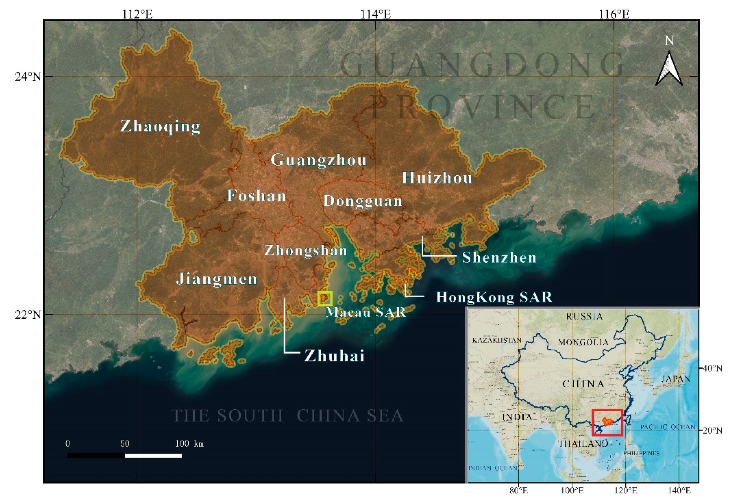
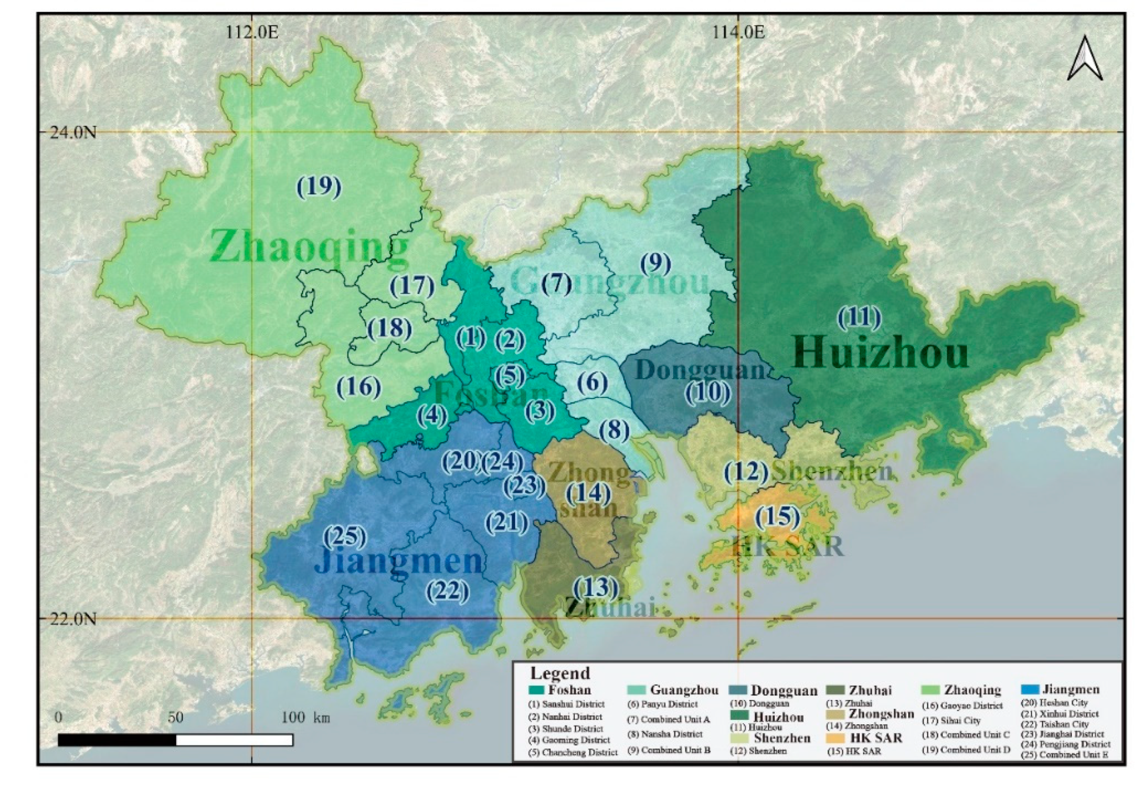
2.1. Study Area
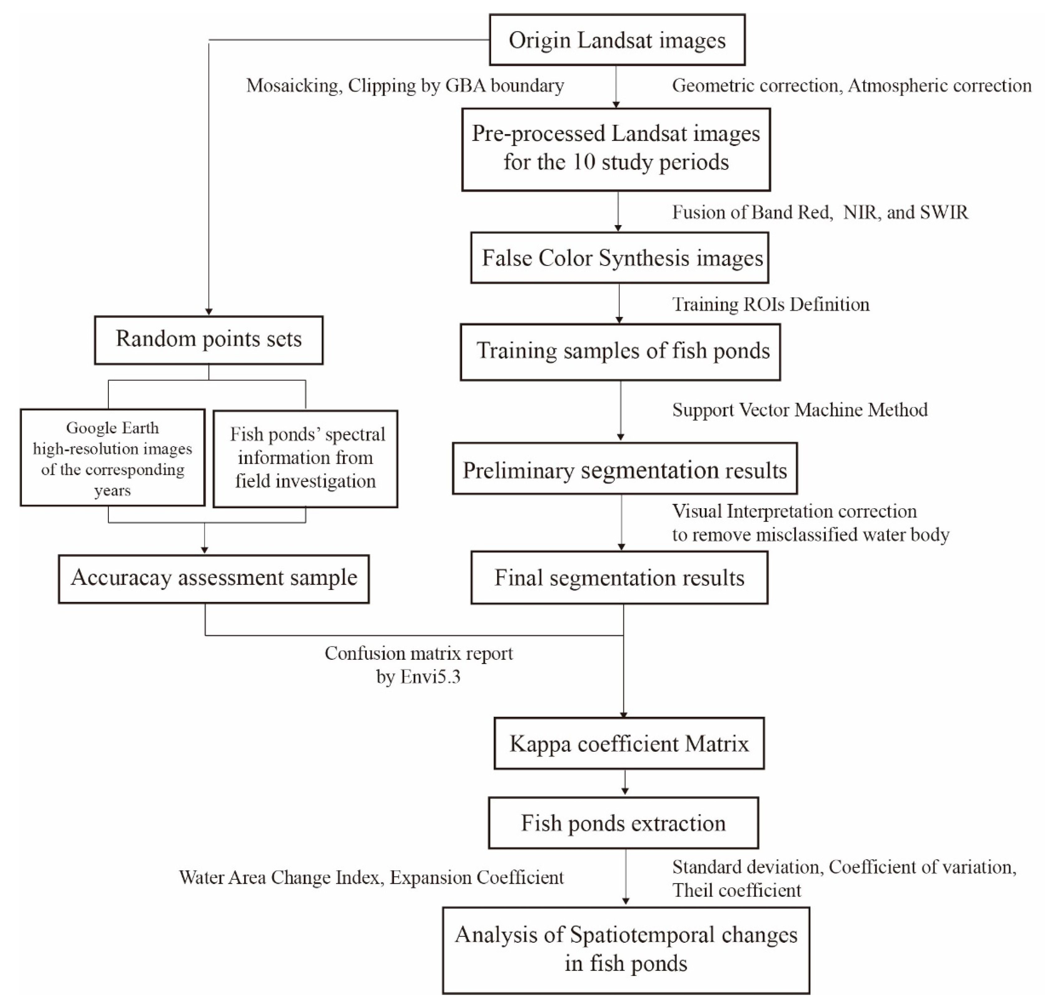
2.2. Data Collection and Image Analysis
2.2.1. Data Source
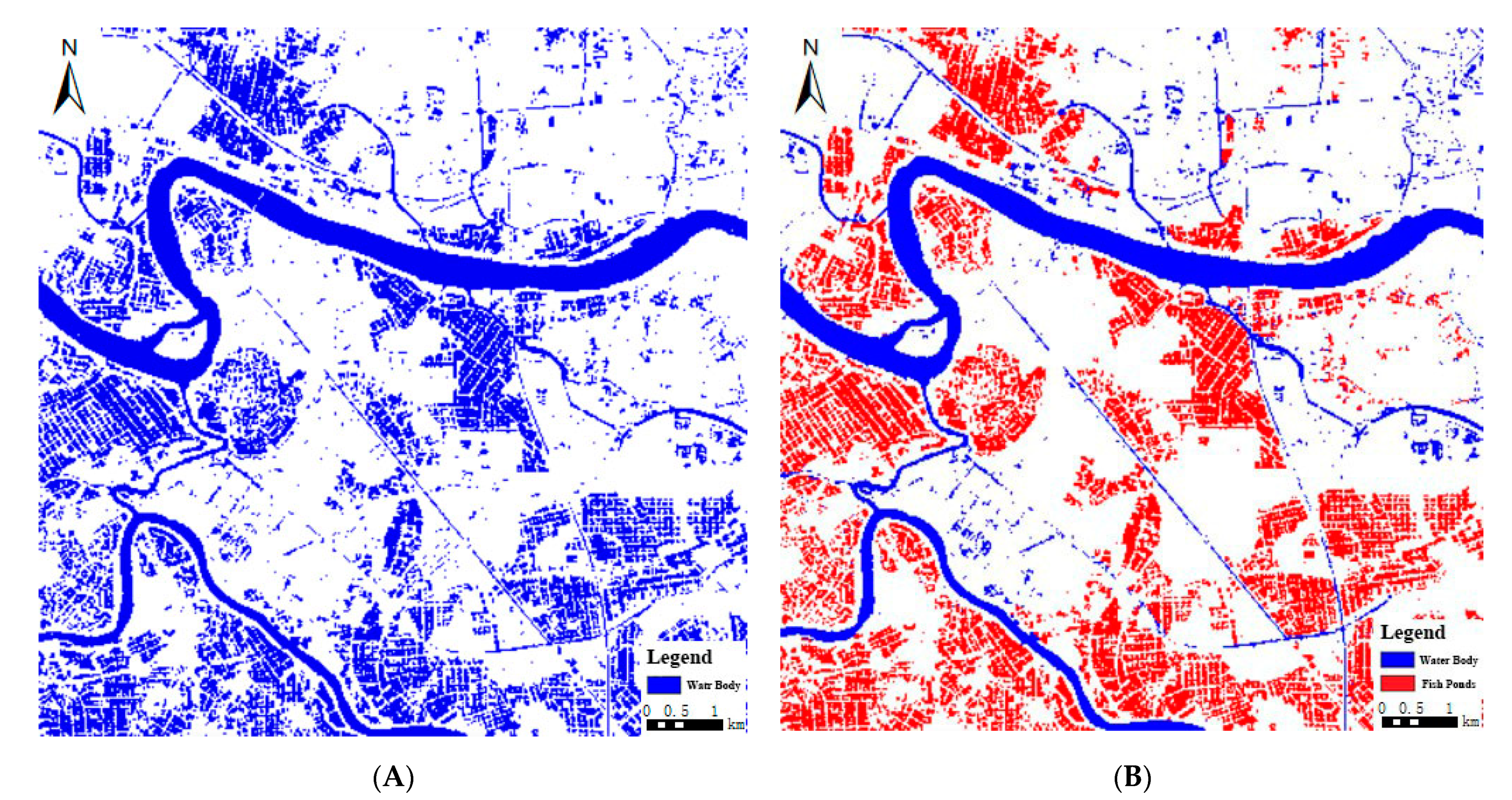
2.2.2. Image Classification
2.3. Methods
2.3.1. Quantitative Evaluation Method
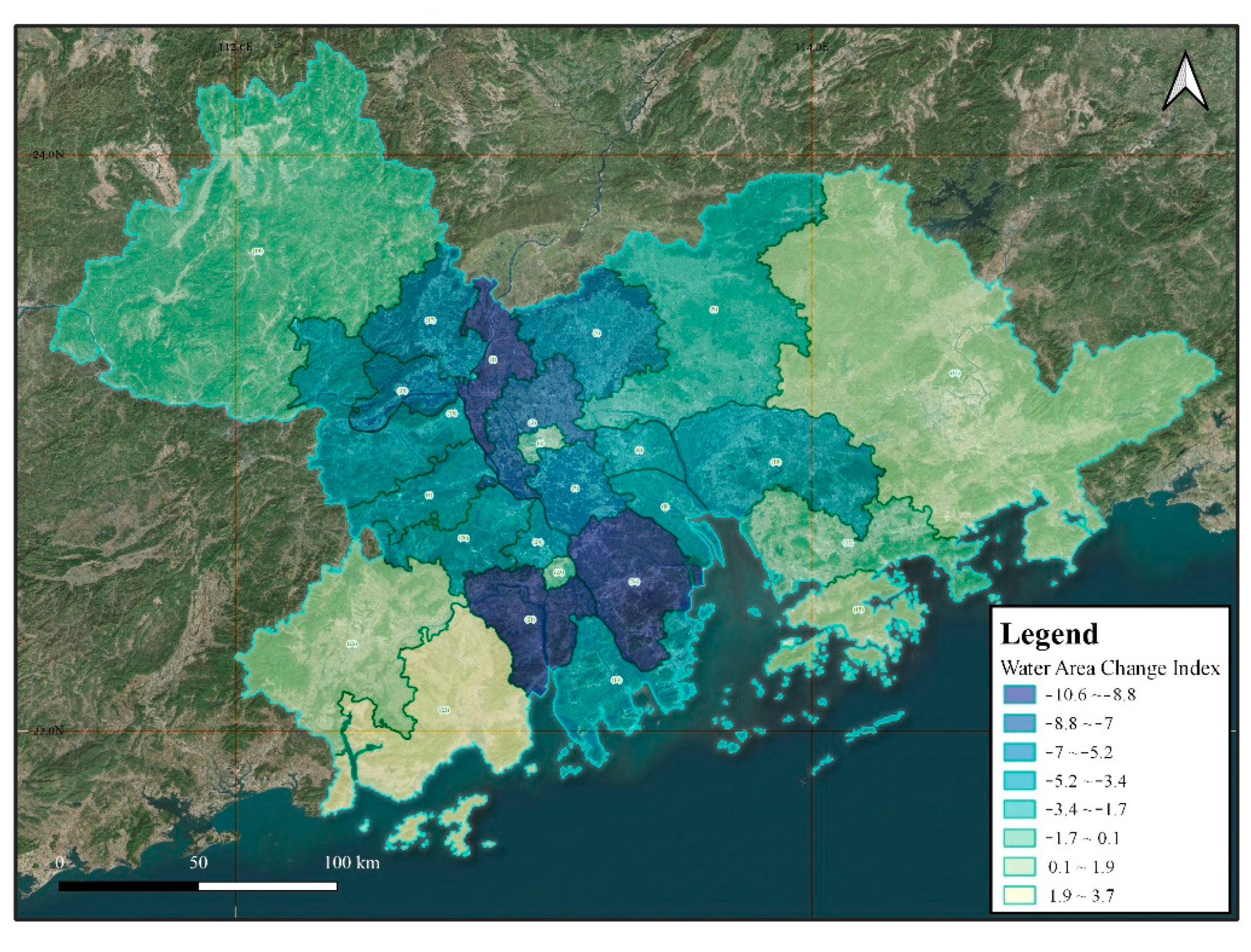
2.3.2. Water Area Change Index (W)
2.3.3. Expansion Coefficient (E)
2.3.4. Kappa Coefficient
3. Results
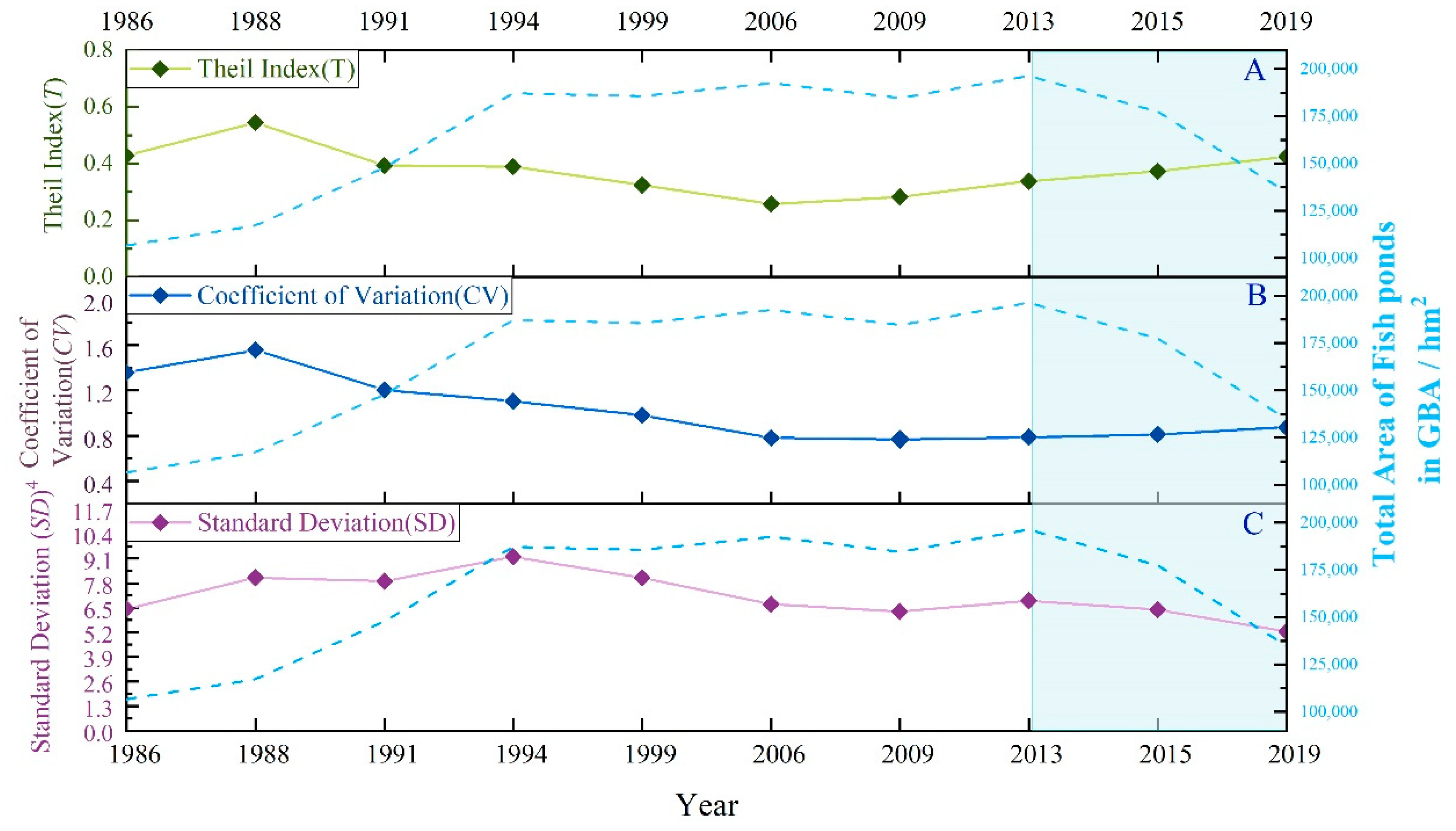
3.1. The Dynamics of Fish Ponds across the GBA
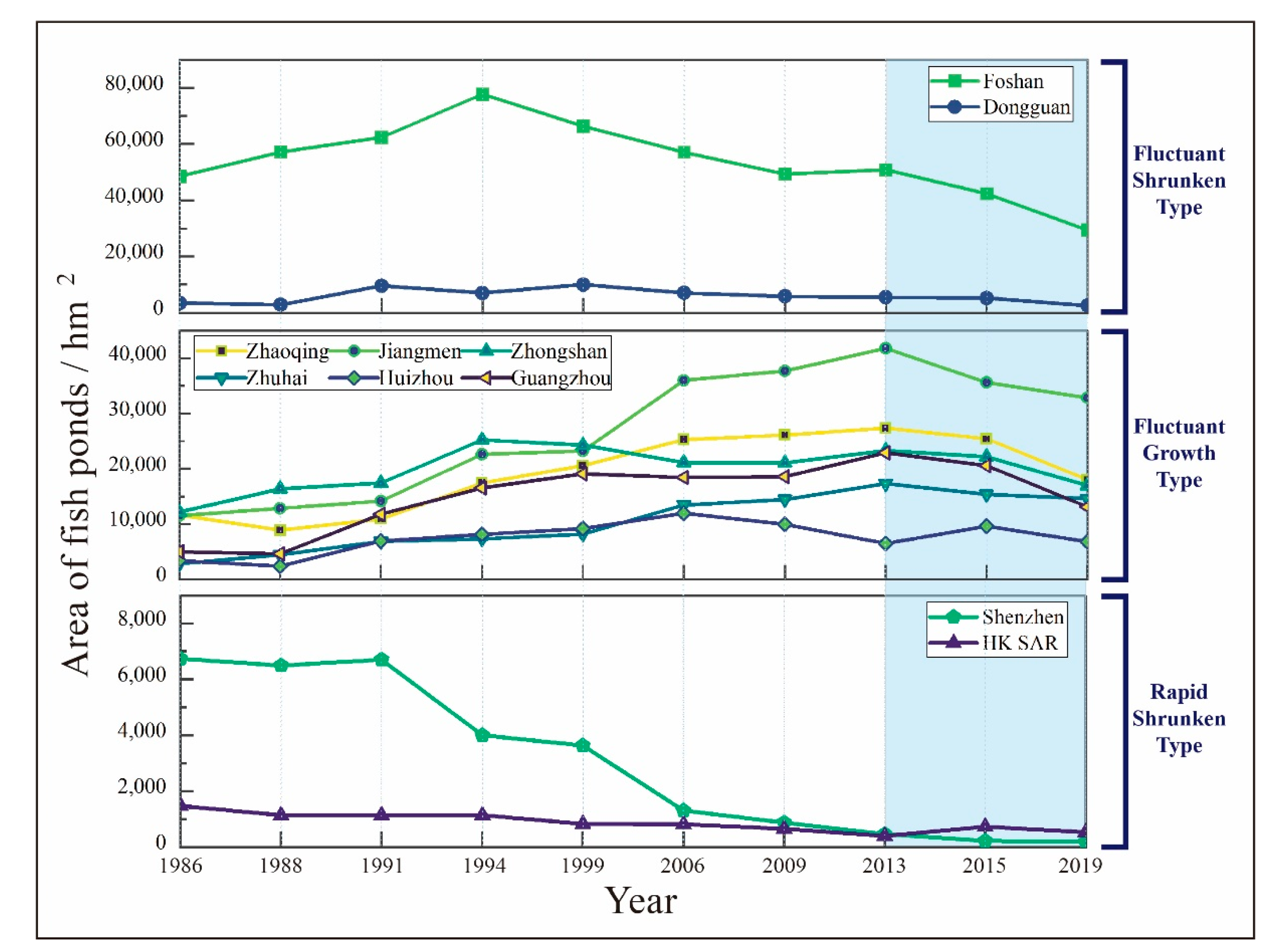
3.2. The Areal Variation Trends in the Prefectural Cities
3.3. The Spatio Patterns in Areal Dynamics among Study Units
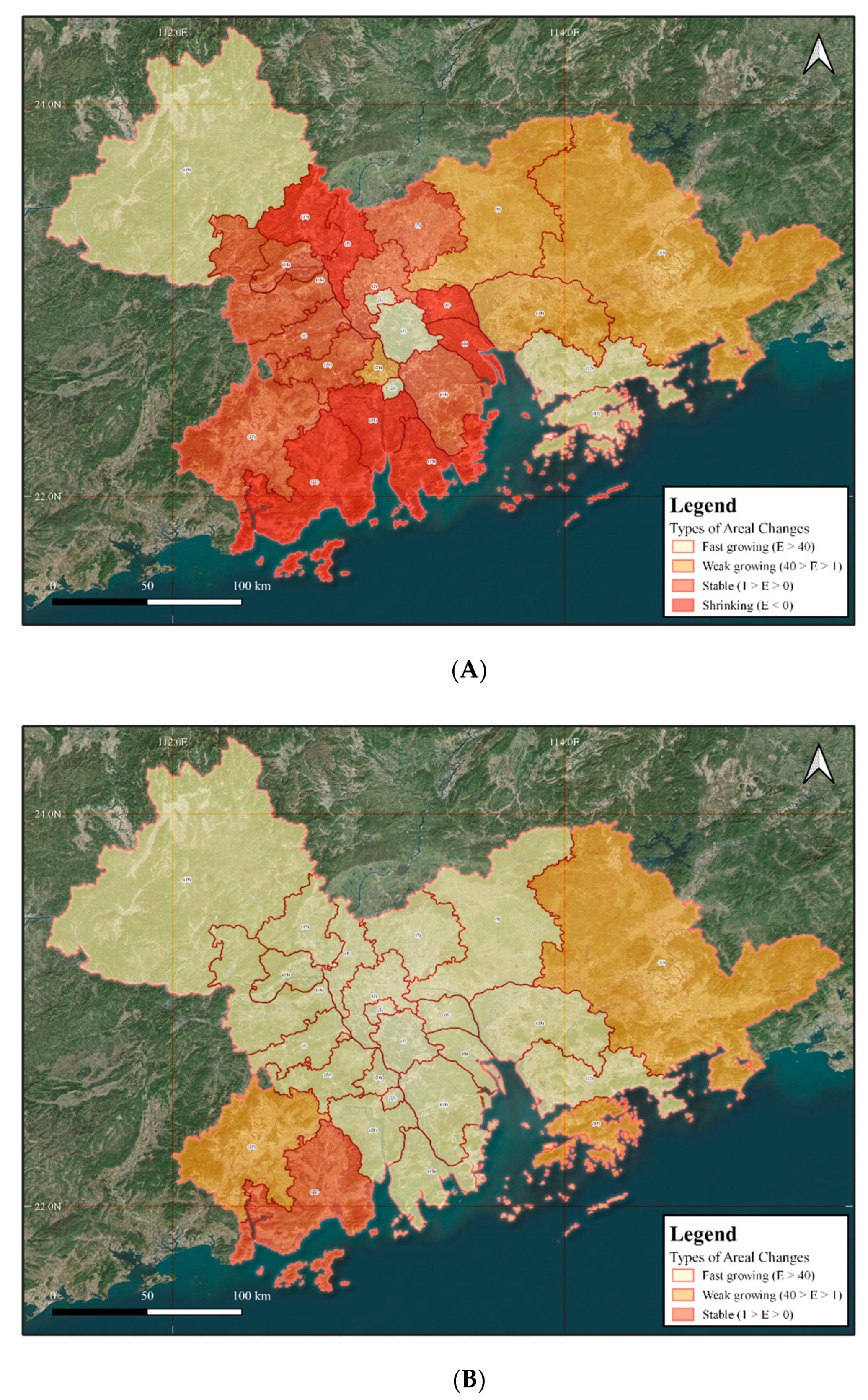
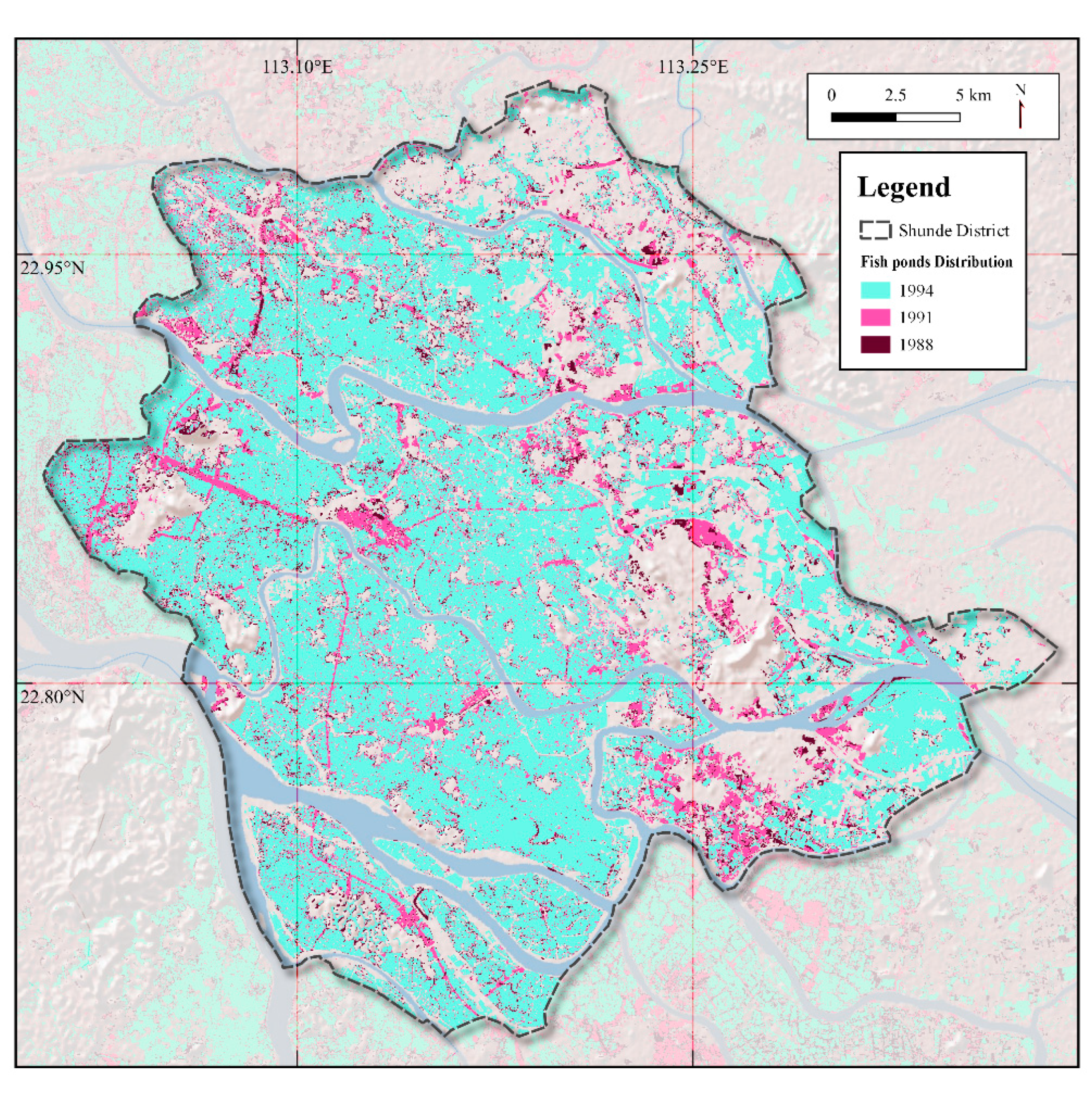
3.3.1. The First Stage (1986–2013)
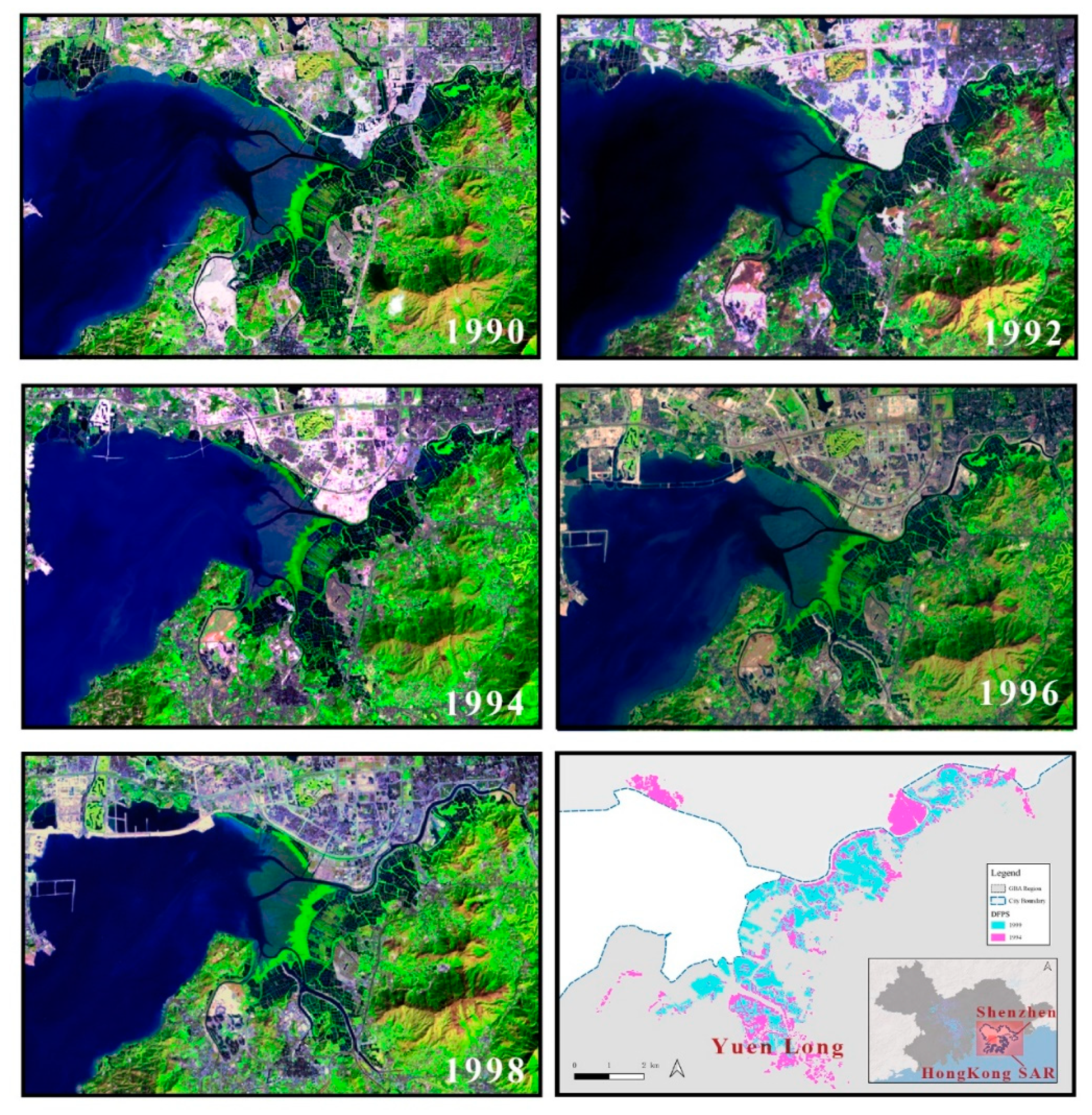
3.3.2. The Second Stage (2013–2019)
4. Discussion
4.1. Uncertainty Analysis
4.1.1. Accuracy Assessment
4.1.2. Comparisons with Previous Studies
4.2. Possible Causes for Pond Changes in Different Cities and Future Speculation
4.2.1. The Growing Cities
4.2.2. The Shrinking Cities
4.2.3. The Fast Shrinking Cities
4.2.4. Future Trends of Fish Ponds in GBA
5. Conclusions
Author Contributions
Funding
Institutional Review Board Statement
Informed Consent Statement
Data Availability Statement
Acknowledgments
Conflicts of Interest
References
- Liu, S.; Min, Q.; Jiao, W.; Liu, C.; Yin, J. Integrated emergy and economic evaluation of Huzhou mulberry-dyke and fish-pond systems. Sustainability 2018, 10, 3860. [Google Scholar] [CrossRef] [Green Version]
- Zhong, G. The characteristics of dike-pond system and the practical significance. Sci. Geogr. Sin. 1988, 8, 12–17, 99. [Google Scholar]
- Astudillo, M.F.; Thalwitz, G.; Vollrath, F. Modern analysis of an ancient integrated farming arrangement: Life cycle assessment of a mulberry dyke and pond system. Int. J. Life Cycle Assess. 2015, 20, 1387–1398. [Google Scholar] [CrossRef]
- Nie, C.; Li, H. The integrated Dike-pond systems: Its new developments and ecological problems. J. Foshan Univ. 2001, 19, 49–53. [Google Scholar]
- Chen, W.; He, B.; Nover, D.; Lu, H.; Liu, J.; Sun, W.; Chen, W. Farm ponds in southern China: Challenges and solutions for conserving a neglected wetland ecosystem. Sci. Total Environ. 2019, 659, 1322–1334. [Google Scholar] [CrossRef]
- Li, M.; Zhang, Y.; Xu, M.; He, L.; Liu, L.; Tang, Q. China Eco-Wisdom: A Review of Sustainability of Agricultural Heritage Systems on Aquatic-Ecological Conservation. Sustainability 2020, 12, 60. [Google Scholar] [CrossRef] [Green Version]
- Guo, S. The Value, Protection and Utilization of Mulberry Ponds in the Pearl River Delta from the Perspective of Agricultural Cultural Heritage. Trop. Geogr. 2010, 30, 114–120. [Google Scholar]
- Liu, K.; Xie, L.; Zhuang, J. Analysis on the evolution of the spatial pattern of the dyke-pond system in Foshan city. Trop. Geogr. 2008, 28, 513–517. [Google Scholar]
- Liu, Z.; Cui, W. Multi-temporal Remote Sensing Analysis of Foshan Dyke-Pond System. Guangdong Agric. Sci. 2017, 44, 126–130, 183. [Google Scholar]
- Lin, M.; Ji, S. Analysis on mode change and landscape pattern of the Dike-pond agriculture in Zhongshan. Guangdong Agric. Sci. 2014, 41, 192–197, 205, 245. [Google Scholar]
- Li, Y.; Liu, K.; Liu, Y.; Zhu, Y. The Dynamic of Dike-Pond System in the Pearl River Delta during 1964–2012. In Global Changes and Natural Disaster Management: Geo-Information Technologies; Springer: Berlin/Heidelberg, Germany, 2017; pp. 47–59. [Google Scholar]
- Mao, Y. The Theoretical Basis and System Innovation of the Construction of Guangdong-Hong Kong-Macao Greater Bay Area. J. Sun-Yatsen Univ. 2019, 59, 173–182. [Google Scholar]
- Han, X.L.; Yu, K.J.; Li, D.H.; Wang, S.S. Building the Landscape Security Pattern of Dike-Pond System with Urban Functions A Case of Magang Part of Shunde District, Foshan City. Areal Res. Dev. 2008, 123, 109–112, 130. [Google Scholar]
- Yan, Y.; Li, Y. The Comparative Study of Remote Sensing Image Supervised Classification Methods Based on ENVI. Beijing Surv. Mapp. 2011, 11, 14–16. [Google Scholar]
- Gong, Z. Ponderation over the Flood Control Functions of the Artifical Landforms in PRD. Trop. Geogr. 2012, 32, 50–56. [Google Scholar]
- Wei, C.T.; Hannes, B.T. Measuring urban agglomeration using a city-scale dasymetric population map: A study in the Pearl River Delta, China. Habitat Int. 2017, 59, 32–43. [Google Scholar] [CrossRef] [Green Version]
- Yang, X.; Lu, X. Drastic change in China’s lakes and reservoirs over the past decades. Sci. Rep. 2014, 4, 1–10. [Google Scholar] [CrossRef] [PubMed] [Green Version]
- Hui, L. Regional inequality measurement: Methods and evaluations. Geogr. Res. 2006, 45, 152–160. [Google Scholar]
- Ye, C. Change characteristics and spatial types of dike-pond in the Pearl River Delta. J. East. China Inst. Technol. 2013, 12, 315–322. [Google Scholar]
- Zhang, W.; Xue, D. Urbanization base of city-land use expansion in the Zhujiang River Delta. J. Nat. Resour. 2003, 18, 64–71. [Google Scholar]
- Cohen, J. A coefficient of agreement for nominal scales. Educ. Psychol. Meas. 1960, 20, 37–46. [Google Scholar] [CrossRef]
- Wu, Y. Analysis of the indicators between urban metabolism and land use change in Guangzhou. Geogr. Res. 2011, 14, 478. [Google Scholar]
- Yang, X.; Lu, X. Delineation of lakes and reservoirs in large river basins: An example of the Yangtze River Basin, China. Geomorphology 2013, 190, 92–102. [Google Scholar] [CrossRef]
- Li, F.; Liu, K.; Tang, H.; Liu, L.; Liu, H. Analyzing Trends of Dike-Ponds between 1978 and 2016 Using Multi-Source Remote Sensing Images in Shunde District of South China. Sustainability 2018, 10, 3504. [Google Scholar] [CrossRef] [Green Version]
- Li, J.; Du, Y.; Cai, A. Change Characteristics of Coastal Wetlands in the Pearl River Delta under Rapid Urbanization. Wetl. Sci. 2019, 17, 267. [Google Scholar]
- Chen, J. The Evolution of Reclamation Area and Its Impact on Land Resource Utilization; Guangzhou University: Guangzhou, China, 2018. [Google Scholar]
- Yang, M.; Qu, L.; Zhang, Y. The Driving Mechanism of Cultivated Land Change in the Development and Utilization of Core Regions in the Outer Peripheral of the Pearl River Delta in the Past Ten Years—A Case Study of Dinghu District. In Proceedings of the Annual Conference of China Land Society 2008, Hefei, China, 12 October 2008; pp. 599–603. [Google Scholar]
- Wu, D.; Dong, Y.; Liu, H.; Ni, S. Analysis on the Spatial-temporal Changes of Cultivated Land and Their Driving Forces in Zhuhai. Trop. Geogr. 2009, 29, 472–476, 482. [Google Scholar]
- Zhong, S. Reasearch on Coordinated Development of Regional Resources, Environment and Economy—A Case Study of Zhuhai City; Jilin University: Changchun, China, 2013. [Google Scholar]
- Zhuhai Municipal Bureau of Agriculture. Work Plan for the Construction of Jiangmen Modern Agriculture Comprehensive Demonstration Base. 2009. [Google Scholar]
- Liu, Y.; Lin, H. Spatial-Temporal Changes and Mechanism of Land Use in the Pearl River Delta from the Perspective of Property Rights Alteration: A Case Study of Nanhai District in Foshan City. Trop. Geogr. 2019, 39, 54–65. [Google Scholar]
- Gui, D. A Preliminary Study on the Development Track of Foshan’s Private Economy. Guangdong Econ. 2010, 162, 47–53. [Google Scholar]
- Government of Guangdong Province. Strategic Plan for the Implementation of Rural Revitalization in Guangdong Province (2018–2022). 2019. [Google Scholar]


| Years | Area/hm2 | Standard Deviation | Coefficient of Variation (CV) | Theil Index (T) |
|---|---|---|---|---|
| 1986 | 106,602.8 | 64,359.503 | 1.358 | 0.428 |
| 1988 | 117,164.4 | 80,927.218 | 1.554 | 0.544 |
| 1991 | 147,796.0 | 78,997.455 | 1.203 | 0.393 |
| 1994 | 187,153.1 | 91,933.360 | 1.105 | 0.389 |
| 1999 | 185,677.6 | 80,891.375 | 0.980 | 0.324 |
| 2006 | 192,497.4 | 66,908.650 | 0.782 | 0.257 |
| 2009 | 184,589.5 | 63,026.680 | 0.768 | 0.282 |
| 2013 | 1963.5.6 | 68,612.618 | 0.786 | 0.338 |
| 2015 | 177,377.5 | 63,978.322 | 0.812 | 0.373 |
| 2019 | 134,873.6 | 52,474.643 | 0.875 | 0.424 |
| Year | Kappa Coefficient | Year | Kappa Coefficient |
|---|---|---|---|
| 1986 | 0.81 | 2006 | 0.86 |
| 1988 | 0.85 | 2009 | 0.83 |
| 1991 | 0.84 | 2013 | 0.80 |
| 1994 | 0.82 | 2015 | 0.81 |
| 1999 | 0.80 | 2019 | 0.80 |
| Year | Li’s Study (km2) | Year | This Study (km2) | Percentage of Difference |
|---|---|---|---|---|
| 1988 | 41.17 | - | 45.86 | 4.69% |
| - | - | 1991 | 117.62 | - |
| - | - | 1994 | 165.15 | - |
| 2000 | 203.06 | 1999 | 190.56 | 12.49% |
| - | - | 2006 | 184.20 | - |
| - | - | 2009 | 185.51 | - |
| 2012 | 213.44 | 2013 | 228.62 | 15.18% |
Publisher’s Note: MDPI stays neutral with regard to jurisdictional claims in published maps and institutional affiliations. |
© 2021 by the authors. Licensee MDPI, Basel, Switzerland. This article is an open access article distributed under the terms and conditions of the Creative Commons Attribution (CC BY) license (https://creativecommons.org/licenses/by/4.0/).
Share and Cite
Zhang, W.; Cheng, Z.; Qiu, J.; Park, E.; Ran, L.; Xie, X.; Yang, X. Spatiotemporal Changes in Mulberry-Dyke-Fish Ponds in the Guangdong-Hong Kong-Macao Greater Bay Area over the Past 40 Years. Water 2021, 13, 2953. https://doi.org/10.3390/w13212953
Zhang W, Cheng Z, Qiu J, Park E, Ran L, Xie X, Yang X. Spatiotemporal Changes in Mulberry-Dyke-Fish Ponds in the Guangdong-Hong Kong-Macao Greater Bay Area over the Past 40 Years. Water. 2021; 13(21):2953. https://doi.org/10.3390/w13212953
Chicago/Turabian StyleZhang, Wenxin, Zihao Cheng, Junliang Qiu, Edward Park, Lishan Ran, Xuetong Xie, and Xiankun Yang. 2021. "Spatiotemporal Changes in Mulberry-Dyke-Fish Ponds in the Guangdong-Hong Kong-Macao Greater Bay Area over the Past 40 Years" Water 13, no. 21: 2953. https://doi.org/10.3390/w13212953
APA StyleZhang, W., Cheng, Z., Qiu, J., Park, E., Ran, L., Xie, X., & Yang, X. (2021). Spatiotemporal Changes in Mulberry-Dyke-Fish Ponds in the Guangdong-Hong Kong-Macao Greater Bay Area over the Past 40 Years. Water, 13(21), 2953. https://doi.org/10.3390/w13212953