1. Introduction
Surface water ecosystems worldwide are deteriorating at an alarming rate under ever-increasing human pressures and climate change [
1,
2,
3], threatening biodiversity and ecosystem services that link to human water security and public health [
4,
5,
6,
7]. Notably, increases in agricultural productivity, urbanization, and their associated impacts have multiplied the number and severity of stressors to surface waters since the middle of the 20th century. Anthropogenic changes to the soil surface and sub-surface (e.g., drainage network) have resulted in important flow alterations that can have direct ecological consequences or indirect consequences via water quality impairment stemming from enhanced loads of nutrients or pollutants [
8,
9,
10]. Bioeconomy-related pressures resulting from the drive towards green transition solutions in response to climate change threats may pose additional threats to stream water quality [
11].
Streams draining peri-urban landscapes (as defined in [
12]) are a prime example of such systems, with great potential to be impacted by the heterogeneous sprawl of urban, industrial, and agricultural activities coexisting with natural areas that may be found sporadically throughout a given catchment. The combination of various hydrological pathways and related response times, with faster drainage from impervious urban areas compared to more natural ones, results in high spatial and temporal variability at different scales, as reported in [
13,
14,
15]. Moreover, measurements taken in these types of catchments are still generally insufficient to capture—spatially or temporally—the driving processes leading to these variations, which are needed to ensure effective mitigation strategies and sustainable decision-making [
16]. Management decisions regarding stream flow and quality within the peri-urban landscape are thus extremely challenging. Integrated water quality models, i.e., considering the mutual interaction of flow and quality with potential for integration with the broader socio-economical-ecological system, are therefore essential tools to support water resources management and facilitate decision-making, as advocated in a recent review of water quality models ([
17]).
Many hydrological and water quality models have been developed over the years. These models can be classified by increasing degree of complexity from statistical (e.g., regression-based) to more mechanistic models (physical description of processes), and spatially from lumped to physically distributed, chosen depending on the application purpose. Widely applied water quality models (based on a number of published studies over the last 20 years [
18]) include the Soil and Water Assessment Tool (SWAT) [
19], WASP [
20], QUAL2E/K [
21], AQUATOX [
22], and the MIKE series [
23]. However, their use to simultaneously address the hydrology and water quality of streams within peri-urban contexts is challenging. Reasons for this may lie in the reliance on a hydrodynamic model not yet fully adapted to the peri-urban context [
24], the large data requirement, and the parametrization level necessary when using spatially distributed models. This can also cause long simulation times [
25] and/or difficulty in accounting for the inherent uncertainty and high variability of input data [
26].
Consequently, specific research-based models have been developed for investigating peri-urban streams. However, these models tend to be fragmented in sub-disciplines, e.g., focusing on the hydrology [
27] or targeting a specific water quality aspect, e.g., identifying source contribution and pathways for pesticide pollution [
28]. While they certainly have the capability to perform integrated simulations or to be further developed by being coupled together, their interfacing (data format, calculation time step) may not be straightforward. Machine learning techniques have become extremely popular for water quality (for instance, for the prediction of pH, suspended solids, and ammonium concentration using different algorithms in [
29]), possibly coupled to other models (e.g., application of artificial neural networks coupled with SWAT in [
30]) and could therefore be applied in peri-urban settings. Nevertheless, these models also rely heavily on data and may be limited in terms of direct (cause-effect) links to process understanding and thus decision-support capabilities, as experienced by [
31]. Finally, and to this day, very few models offer the possibility and flexibility for stakeholder engagement, the inclusion of local knowledge, and integration capabilities at a higher level for socio-economical-ecological consideration, which is deemed necessary for better and more acceptable stream water management [
26].
A promising solution that can fill the gap in terms of watershed modeling approaches, capable of offering users a holistic and reliable understanding of the systems involved, including uncertainties related to both linear and nonlinear dependencies within and across sub-systems, is system dynamics (SD) simulation. The approach is based on the implementation of an interconnected system of flows and stocks, whose structure gives rise to the dynamic behavior [
32]. SD introduces flexibility lacking in many other methods, including faster model development and shorter simulation time, ability to simulate interactions and thus interdependencies between model sub-systems, and improved transparency for conceptual understanding of the system and thus communication of model results [
33]. Moreover, the benefits of SD for water resources modeling are numerous, e.g., multidisciplinary aspects, causality analysis, stakeholder participation, as documented in [
34,
35], and it has been broadly applied to numerous environmental (e.g., climate change [
36], waste management issues [
37]) and water resource management issues at different spatial scales (see
Section 2.1 below).
Although SD simulation continues to gain traction as a useful tool, there is still a gap with respect to studies utilizing this approach to provide holistic, integrated model insights within the field of water resources modeling and planning [
34], and more specifically, within water quality modeling (see also
Section 2.1). This study aims to fill this gap, presenting an integrated SD model for (1) water quantity and (2) water quality (i.e., physico-chemical conditions), which is used to (3) enhance our understanding of the highly dynamic processes governing water quality in a peri-urban catchment context.
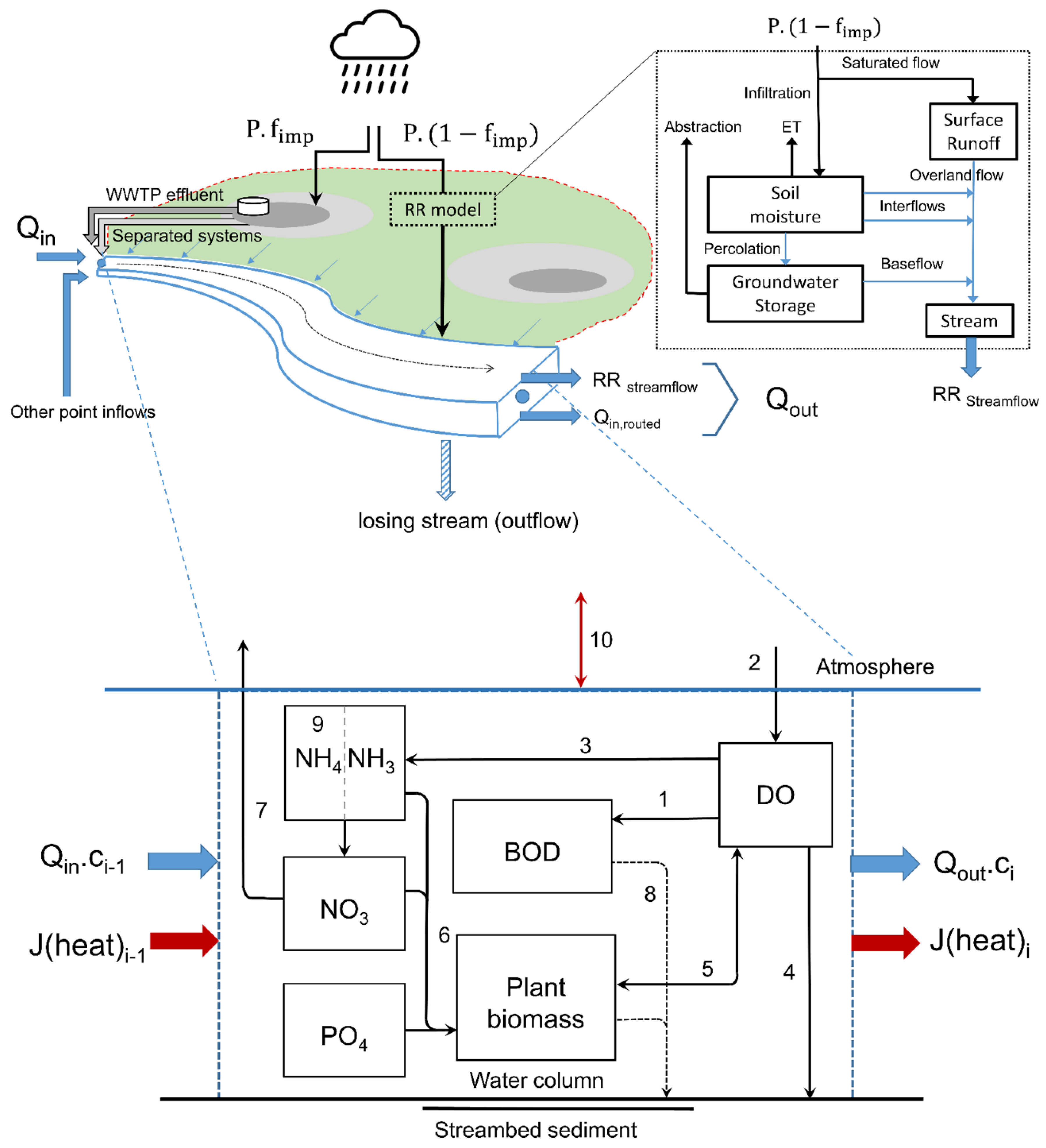
Other SD models exploring water quality and quantity exist (e.g., [
38]); however, these are limited in their exploration of the aforementioned dynamic processes. Modules have been developed, which can be implemented in a plug-and-play fashion, to handle the complexity related to both urban and agricultural/natural land-use features that may be present within a given stream’s reach, in terms of sources and pathways which may impact water quality. The model has been applied in a data-rich catchment to demonstrate its applicability. In this catchment, degraded water and ecological quality have been routinely observed. More specifically, important temporal variations, in terms of dissolved oxygen, temperature, flow, and nutrient discharge from both urban and agricultural areas are possible drivers of ecological degradation, although other stressors (e.g., habitat degradation) co-exist [
39]. Comparison of simulation results with both available sensor and grab sampled data provide valuable insights into the processes affecting peri-urban stream quality and the importance of integrating water quantity and quality modeling to improve system understanding.
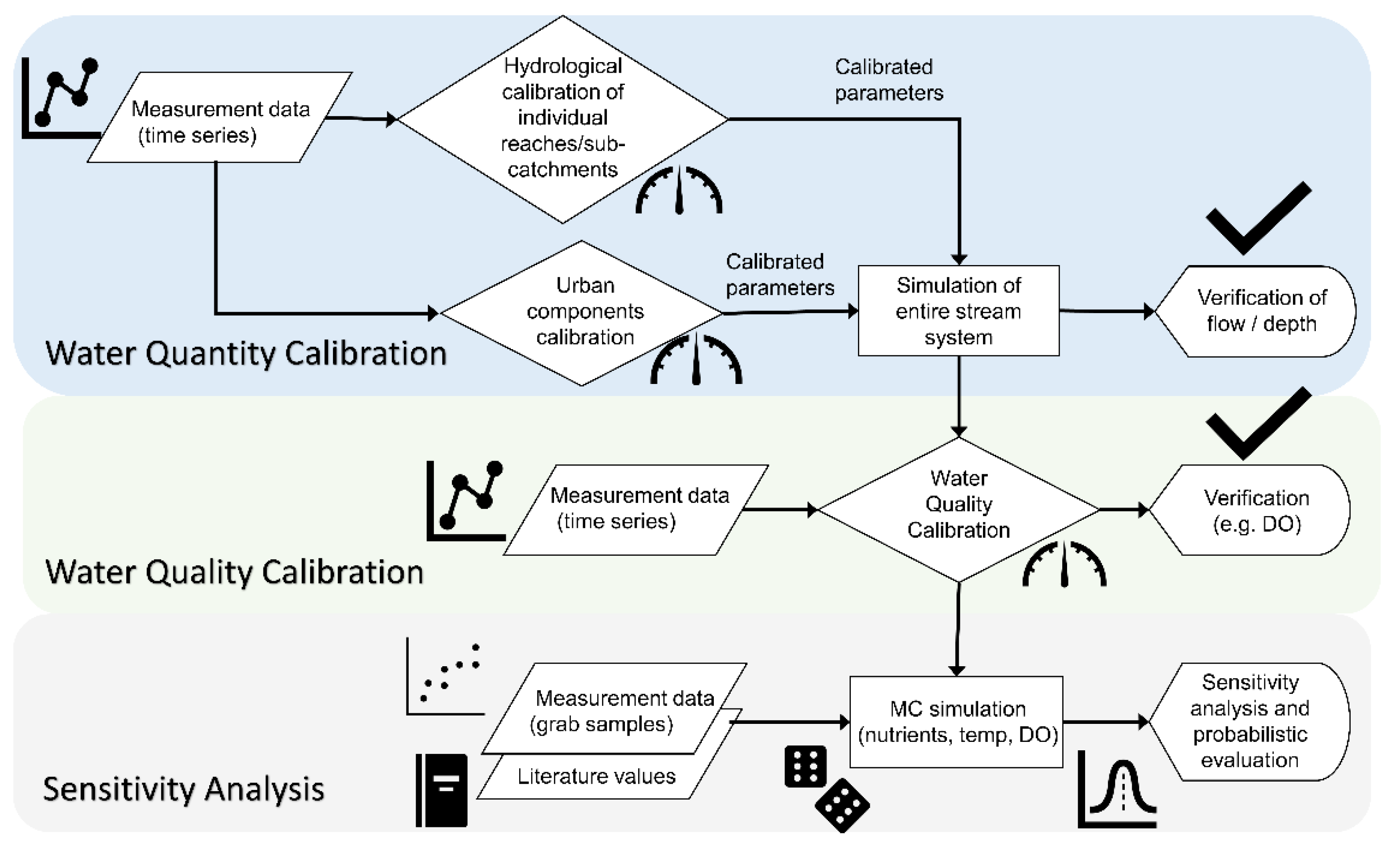
5. Discussion
This SD model and lumped module formulation, implemented as a semi-distributed model structure to capture key spatial variability, enabled the computationally quick and effective simulation of hydrology and water quality variations in a small peri-urban stream. Notably, one of the great advantages of the lumped formulation is a fast simulation time, providing a good opportunity to account for data uncertainty and their inherent variability (i.e., through MC simulation).
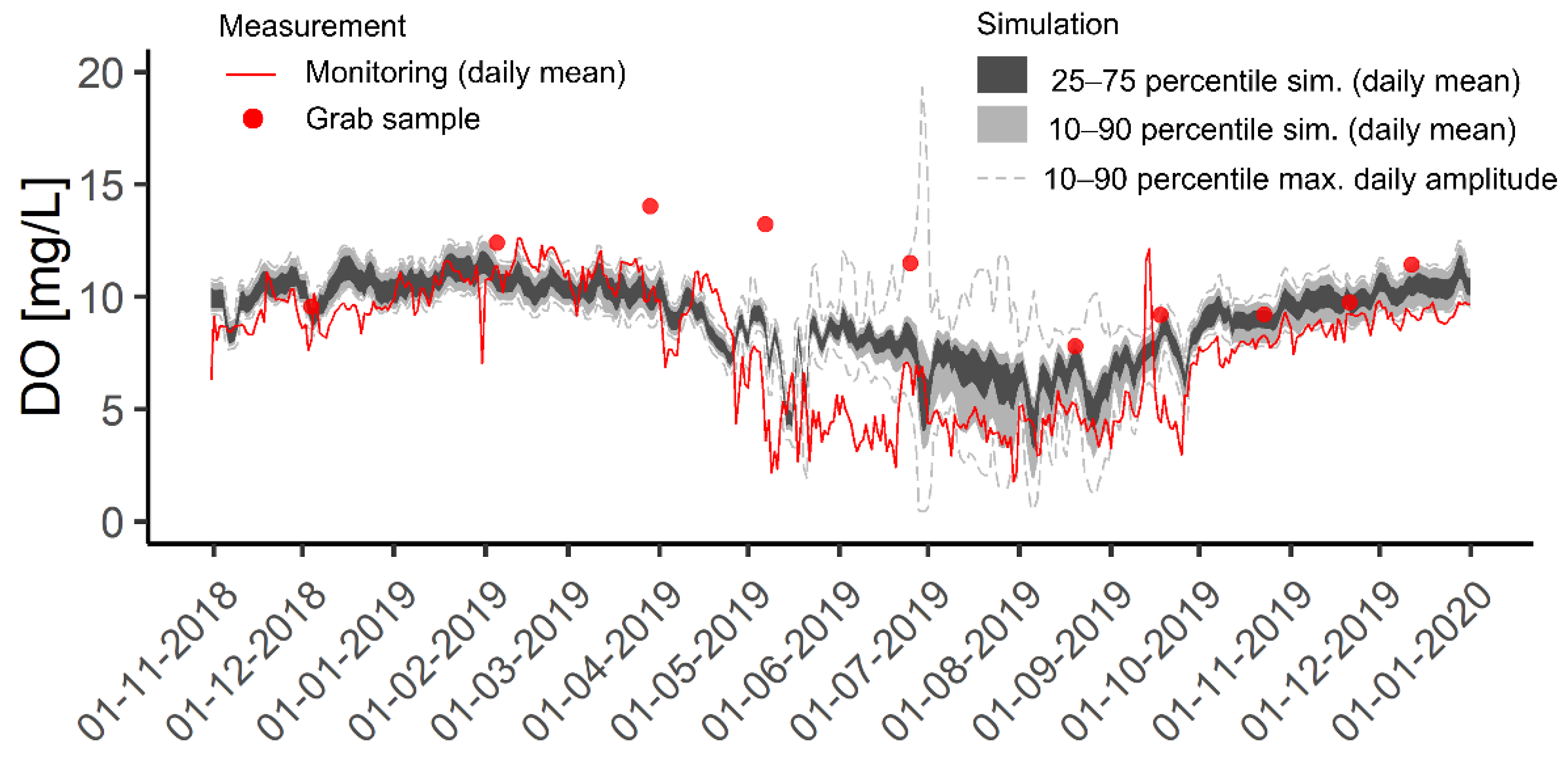
In terms of the hydrological module, the model and the implemented structure captured well the very dynamic contribution of flows stemming from urban and more pervious areas that will influence water quality (with performance indicators ranging from satisfactory to very good). The good results in terms of water depth (RMSE< 0.1 m) highlight the importance of a dynamic and variable Manning’s coefficient, especially for small stream systems like the one modeled here, where shallow water depths combined with underwater vegetation have a strong influence. On the water quality side, the representation of in-stream processes and simulation results for stream temperature, oxygen, and macronutrients (NH4-N, NO3-N, PO4-P) were deemed acceptable compared to the available measured data (based on RMSE and coefficient of determination).
Importantly, the observed discrepancies allowed us to identify key processes affecting the hydrology or water quality in a mixed land-use environment, due in part to the transparency of the model structure allowing the direct inspection of cause-effect system feedbacks (built using an SD approach), as well as potential model improvements and limitations (both discussed further below). This could facilitate a more in-depth analysis of the investigated stream system, which can sometimes be challenging with more complex model structures [
89].
5.1. Process Understanding and Model Application
The combined simulation supported by a rich dataset for our application gives some insightful information on the dynamics processes at stake in peri-urban catchments with strong implications on the general stream water quality.
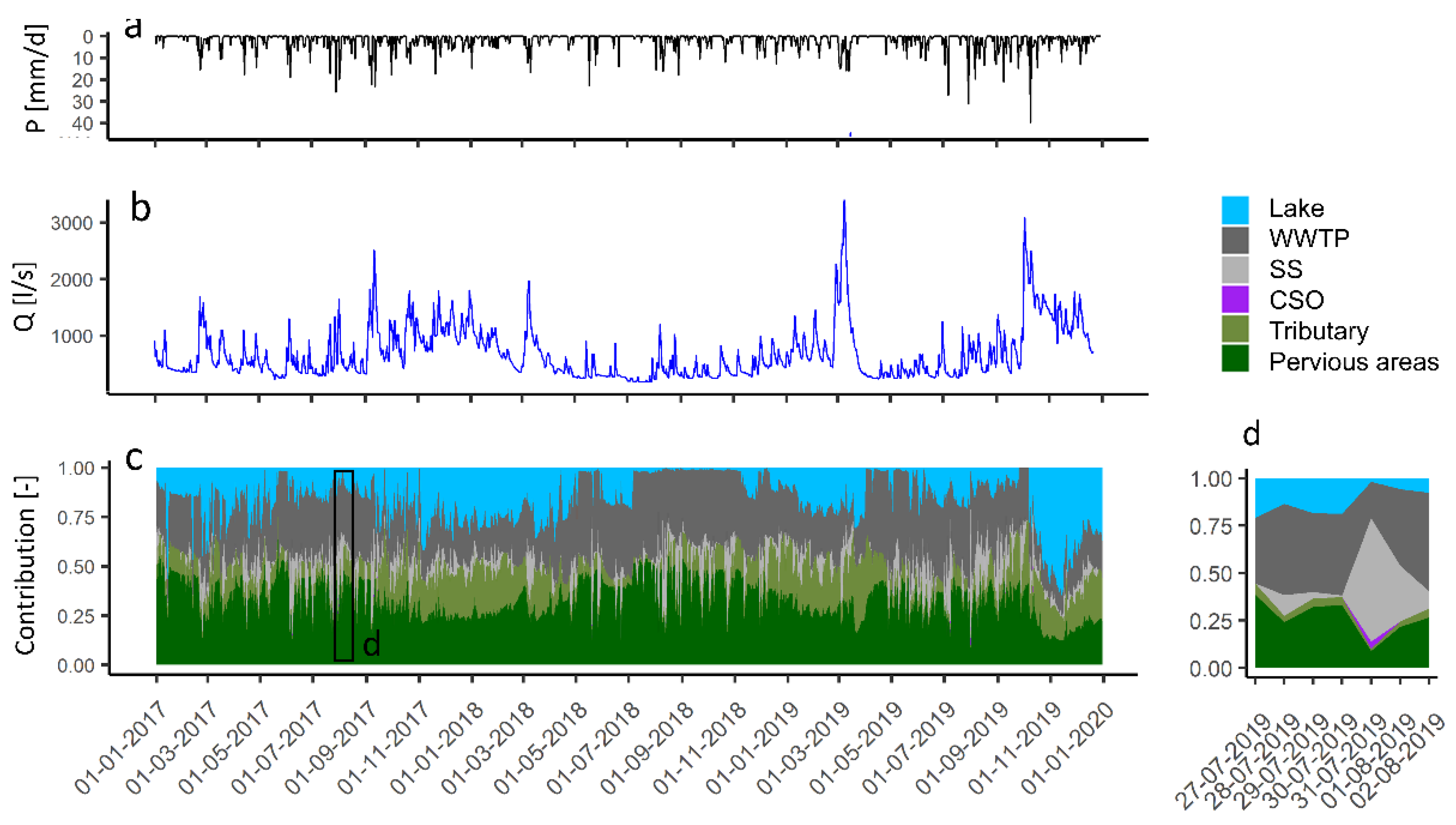
Measurement of nutrient fluxes on a seasonal basis in this catchment showed very dynamic contributions (e.g., nutrients discharge) in the different reaches, confounding the identification of detrimental impacts from sources and land use [
39]. The simulations highlight this important dynamic contribution of the different flow components (
Figure 9), and consequently, the challenges with respect to maintaining good water quality in peri-urban stream systems. There is not one single dominant component, and the effects from the different contributions and associated loadings are naturally very dependent on the local catchment attributes (e.g., degree of urbanization, land-use, type and extent of drainage system). These local differences need to be accounted for when designing restoration strategies that target stream water quality in peri-urban systems [
90]. In our case, the stream reaches could be further divided to check that the current model setup appropriately captures the key attributes governing the conditions in the stream system.
In terms of CSO contribution, it is worth mentioning that the simulation on a daily basis shows that a single CSO event has a quite limited effect in terms of flow due to its relatively short and transient properties (
Figure 9b,d). Nevertheless, the impairment related to particle load (and related degradation) and pollutants (dissolved and particle-bounded) is non-negligible for these structures and underlined as a possible reason for ecological degradation in this catchment, but it is out of the scope of the model at this time.
The results from the stream water quality simulation highlight important seasonal variations of stream water temperature that may be amplified in peri-urban settings. Notably, here, temperatures above 21 degrees Celsius (local threshold value) are estimated during the summer season, with potential adverse effects in terms of DO concentration (due to decrease in DO saturation) and on the stream biota [
91]. The model indicates a limited stream thermal inertia (driven by the shallow depth and fast equilibrium rate with the atmosphere, not shown), resulting in the stream water temperature being strongly correlated to the air temperature as the main explanation. Furthermore, the extent of urban and impervious areas and relative contributions to the peri-urban stream system can exacerbate this problem. Generally, air temperatures in the urban areas are higher, and runoff on heated impervious areas drained via a separated system can contribute as well [
92].
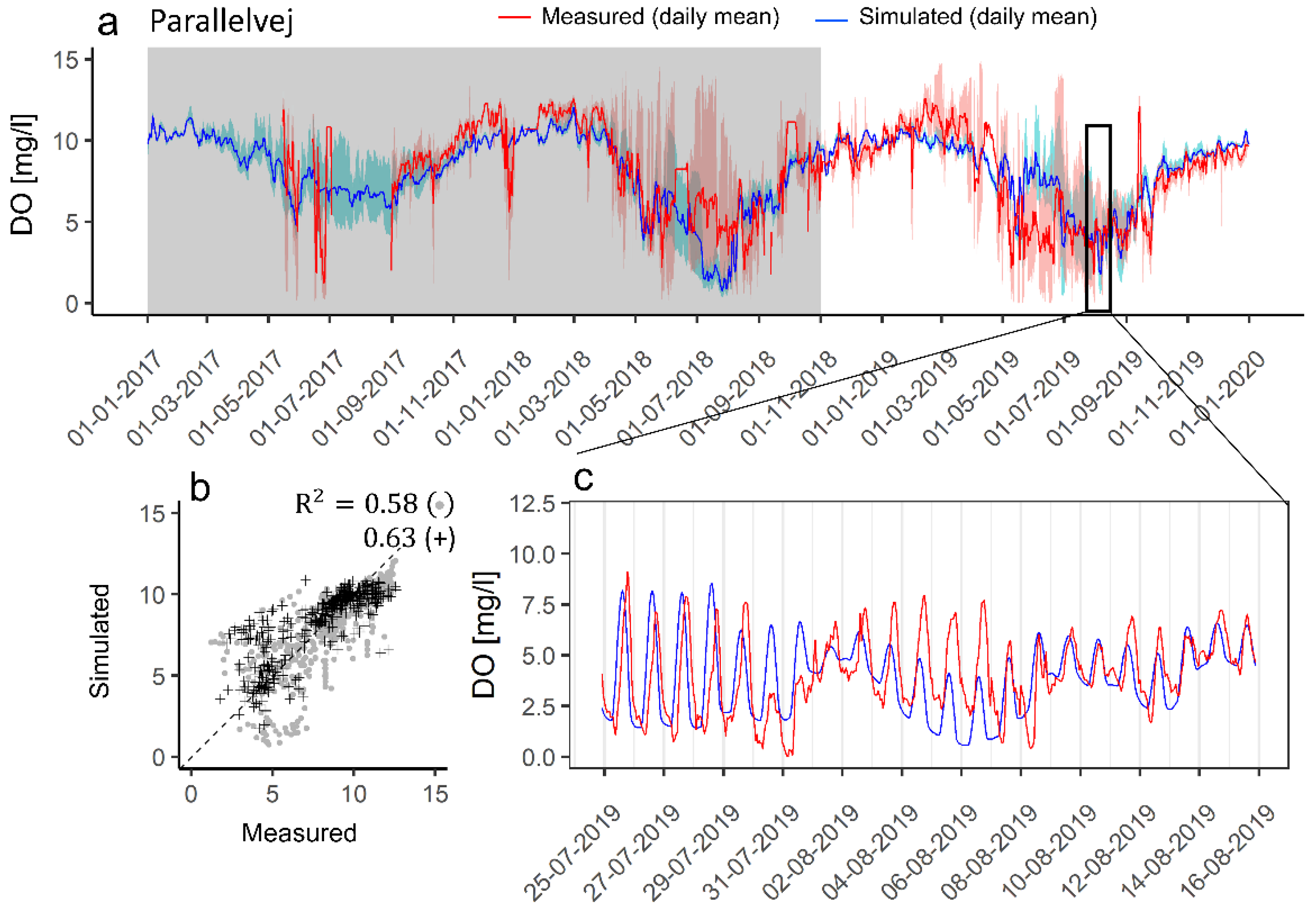
The simulation of DO concentrations shows high heterotrophic respiration events during the summer and beginning of autumn (May–October) that appear as the cause of sustained periods at relatively low daily DO levels witnessed in this catchment. This observation is in agreement with freshwater ecosystem metabolism being generally heterotrophic [
64]. However, this heterotrophic state seems highly dynamic in time and space and does not always result in significant DO depletion (see, e.g., the difference in measured DO saturation levels between two consecutive years, 2018 and 2019, in
Figure S11). Several studies highlighted that urbanization leads to increased and highly dynamic loads of more labile dissolved organic matter fraction and enhanced heterotrophic respiration [
93,
94], which will constitute a challenge in peri-urban settings considering the myriad of delivery pathways. Another possible driving mechanism could be algae blooms phenomena followed by settling and decomposition (as discussed in
Section 4.2.2) or aquatic plant biomass, with macrophytes strongly affecting the local flow conditions, resulting in flow velocity reduction, fine sediment accumulation, and ultimately, enhanced metabolism in lowland streams, as shown in [
56] for another small shallow stream. To this day, the modeling of this type of interaction and understanding of heterotrophic respiration is still limited (but see [
95] and a coupled model of stream metabolism and microbial biomass, calibrated on long-term monitoring series ) and constitute an important source of uncertainty for any DO simulation in water quality models [
82].
Finally, the sustained period of low dissolved oxygen previously described may also create favorable conditions for the enhanced release of nutrients. The simulations revealed, for example, an underestimation of phosphorus concentrations compared to the observed data. While unknown sources such as agricultural drainage or septic tanks cannot be excluded in peri-urban catchments and should be investigated further, several studies pointed out an enhanced release of reactive and legacy phosphorus in summer periods under low DO conditions for both mixed and single land-use streams [
56,
85,
87]. Such a process can become an important feedback mechanism. The released nutrients sustain aquatic plant biomass and favor increased organic matter settling and decomposition and, thus, oxygen depletion as previously mentioned, especially if P is a limiting factor or other sources of reactive phosphorus (e.g., urban effluents) are removed or controlled. Notably, in the investigated catchment, the push towards green transition solutions for more resource and energy-efficient water treatment systems may result in centralized systems, with the suppression of urban effluent outlets [
96]. While the benefit of such a solution is obvious in terms of overall environmental impact (e.g., carbon reduction and energy savings), is evident, it may come with trade-offs for the receiving waters (impacting biodiversity) that should be considered holistically, e.g., enhanced residence time due to flow reduction, lower depth, reduced thermal inertia, and more particle settling triggering some of the impairment mechanisms previously described.
5.2. Future Model Development and Data Needs
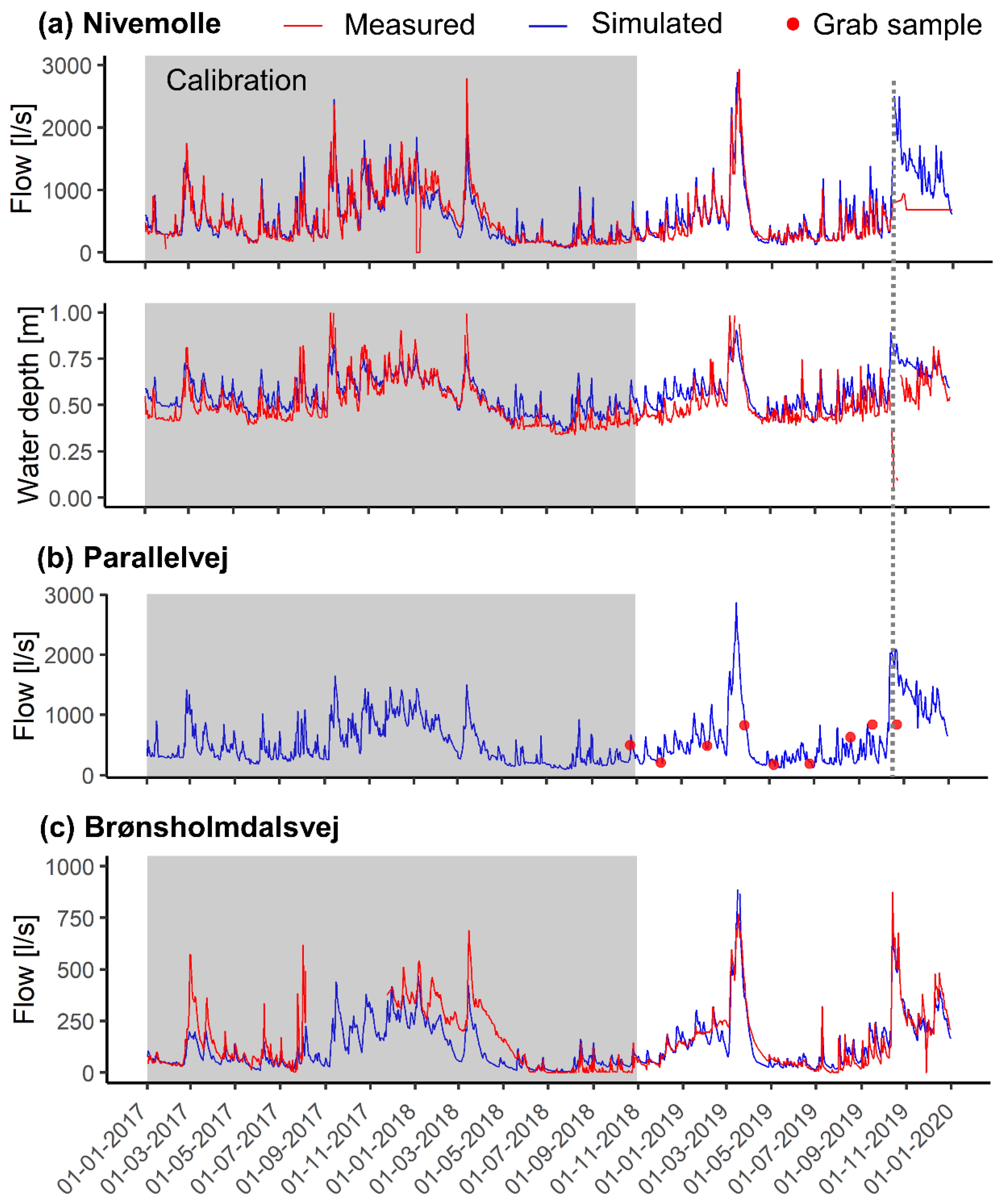
The results from the hydrological model were generally simulated well; however, some of the deviations observed in the period of extreme flows could not be entirely captured. The verification period for the three reaches comprising
Usserød Stream finished 10 October 2019 (vertical dashed line in
Figure 5), when the simulation started to deviate from the observations significantly. Floodplain inundation (flooding likely associated with a reduced channel capacity and high flows) strongly altered the flow regime and could not be handled with the current model structure (1-D system). Secondly, the introduction of a leaking term in the most downstream reach (see
Section 3.3), based on local water abstraction data, was deemed necessary to improve the results during the period of low flows in summer.
Although a local change in geology has not been considered (we assume the calibrated parameters were similar between all reaches), this correction highlights the dynamic interaction between both groundwater and surface water especially important in small stream systems [
97,
98]. This interaction is challenging to handle in hydrological modeling, though critical in lowland catchments, and should be addressed to better understand the flow dynamics in low flow periods (see, e.g., the lump formulation and the coupling between surface water and groundwater using a lump hydrological model formulation in [
99]). Finally, the period of overestimation for the flow at the beginning of the autumn period in the
Donse Tributary (in connection with a possible water impoundment), the deviation between simulated and measured CSOs or the use of some time series (e.g., WWTP effluent; lake sluice data at the most upstream point) underline the importance of anthropogenic features affecting the hydrology and the required knowledge of their active control and stakeholder engagement for improved modeling, as also pointed out in [
26].
The simulations for water quality in the stream are currently limited to the in-stream process. Therefore, a recommended next step would be to address the land source dynamics (e.g., fertilizer and nutrient applications, dissolved organic matter source) and the multiple flow contributions. The simulation of DO concentrations at the sub-daily time step highlights the need for improved characterization of the influence of the aquatic plant biomass, both in terms of spatial coverage but also in terms of autotroph group dynamics, to fully capture the overall dynamics of DO in small peri-urban streams. This task, however, may need to rely on more spatially detailed and high-frequency data, very often not available [
81,
100].
Furthermore, the observed time shift for the diel oscillation cycle points towards potential uncertainty in the reaeration formulation. This uncertainty is especially high for shallow streams but is inherent to any water quality model. It has been observed in [
101] that errors between measured (gas tracer studies) and estimated reaeration coefficient can be up to 30–50%, and even >100% depending on the used formulation and depth/water velocity. The aquatic plant biomass will influence the hydrological model and should ideally have a feedback effect on the hydraulic roughness relationship currently implemented, in addition to their potential to force the settling of suspended sediments. Finally, the deviation in terms of orthophosphate concentration in summertime highlights the potential need for a more detailed process description of the streambed compartment in terms of nutrient cycling and role as a pollutant-bound stock, but also as the scene for complex heterotrophic respiration processes.
6. Conclusions
In this study, we developed an integrated (water quantity and quality) model using a system dynamics approach to investigate the variations and interactions between the flow and physico-chemical parameters (stream temperature, dissolved oxygen, nutrients, and chlorophyll-a) in a peri-urban stream on a daily basis. To our knowledge, this is the first SD model investigating stream hydrology and water quality within a mixed land-use catchment context.
In terms of hydrology, the model performs as well as other integrated models (see, for instance, the flow simulations results in [
82]) with performance indicators, e.g., NSE/RSR, ranging from very good to satisfactory for all reaches in the verification period for both flow and depth variation. It also gives satisfactory results in terms of physico-chemical conditions (stream temperature and dissolved oxygen, NSE/RMSE performance indicators). Notably, the model combined with a rich dataset highlighted the very dynamic contribution of flows stemming from urban and more pervious areas that will greatly influence water quality: inflow of labile dissolved organic matter from the numerous flow pathways triggered in periods of high flow, followed and/or combined with settling and decomposition of algae in periods of low flow may fuel an important heterotrophic activity leading to low dissolved oxygen levels.
The developed model allows the use of probabilistic Monte Carlo simulations to account for the high temporal variability and uncertainty inherent to water quality parameters. Notably, with respect to nutrients, it showed a potential preference for ammonium uptake by macrophytes compared to nitrate. The coupled investigation between simulation and measurements also indicates a potential for remobilization of phosphorus from the sediment in peri-urban streams, which may constitute a critical source for nutrients should other sources (e.g., WWTP effluent) be removed or reduced. Such a process should consequently be accounted for in water quality modeling.
The use of the model in combination with a rich dataset demonstrates, for the first time, that water quality impairments could be further exacerbated by the implementation of a green transition solution (here, rerouting the urban effluents out of the stream system). The sustainability of these solutions should therefore be holistically evaluated to fulfill multi-objective strategies and limit adverse environmental trade-offs.
Overall, the integrated model was valuable in uncovering key insights into the dynamics of a peri-urban stream and, in combination with measured data, revealed that these types of lowland stream catchments may have a high potential to be impacted by green transition solutions. We expect the model’s flexibility, simple structure, and use of system dynamics will constitute a strong advantage for additional stakeholder engagement activities in this catchment and facilitate its ease of transferability and application in others.


 ,
, 


