1. Introduction
Floods are characterized as some of the most severe, dangerous and harmful natural hazards [
1] causing loss of lives and livelihoods, disrupting socio-economic activities and damaging infrastructure. Floods may result from high run-off or a rise in water levels in a particular area that is more than what that environment can contain [
2,
3], and are regular and recurring risks to society [
4]. They cause more economic losses in the world than any other natural hazard and are a major risk to Gross Domestic Product (GDP) [
5]. Economic costs result not only from damages to infrastructure and property, but also include disaster relief efforts towards individuals and businesses. Some floods may also be compounded by poor drainage and culvert designs, poor siting, location of settlements and topographic forces, which are key determinants of vulnerability. Despite these factors, one of the immediate causes of flooding is the occurrence of extreme/intense rainfall in a short duration. Rainfall intensity, volume, timing, and antecedent conditions of rivers and their drainage basins, in addition to human encroachment into flood plains and lack of flood response plans increase the damage potential [
6].
There is evidence that the numbers of people affected and economic damages due to flooding are rising at alarming rates [
7,
8]. This rise is exacerbated by global climate change, as severe storms associated with strong winds and flooding have become more frequent. Climate change has caused greater variability in precipitation patterns, increased intensification and frequent occurrences of natural hazards [
9], increasing the risk of flooding in several regions. Floods are very contextual, suggesting that their impacts and social vulnerability depend on specific circumstances [
10] and may vary from region to region, usually being more severe in developing communities [
11]. This contextually emphasizes the great need for flood risk vulnerability assessments at all spatial scales.
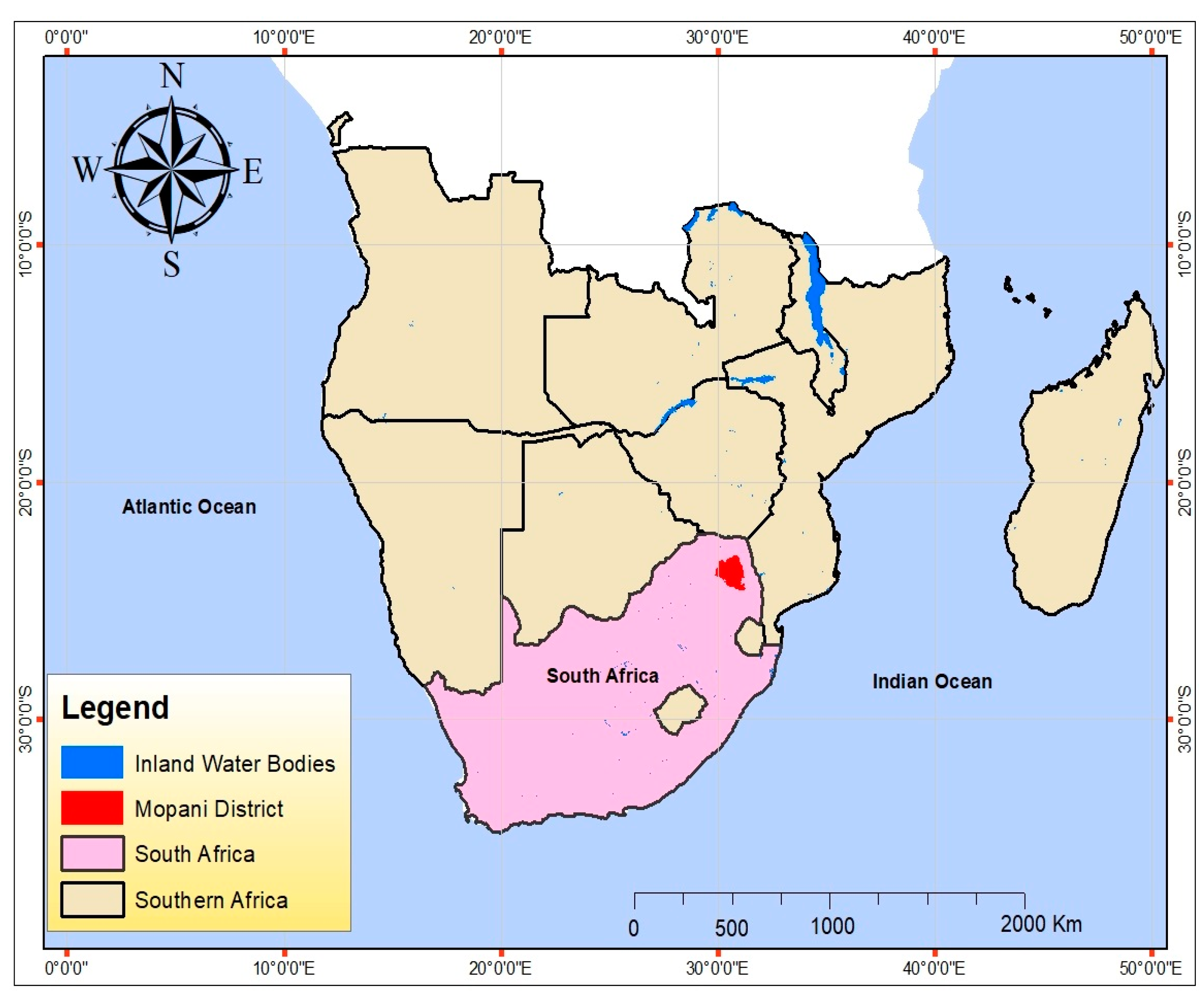
South Africa is exposed and susceptible to flood hazards and the most vulnerable provinces are the Eastern Cape, Kwa-Zulu Natal, the North-West and Limpopo which are largely rural [
12]. Zuma et al. [
13] calculated the risk of flooding in South Africa and found an 83.3% chance of floods occurring in a given year. They also determined that levels of vulnerability are generally high mainly due to socio-economic and geographical factors. It has been found that rural settlements and infrastructure located in valleys and wetlands are more vulnerable to flood risks and disasters [
3]. The effects of population growth, settlement developments and expansion of the rural-urban hinterland have also worsened the magnitude and frequency of flooding or ponding. Poor rural communities are more exposed and have become susceptible or sensitive to flood hazards. In some rural areas of South Africa, flood events disrupt transportation on gravel roads with downstream effects on several socio-economic activities [
14].
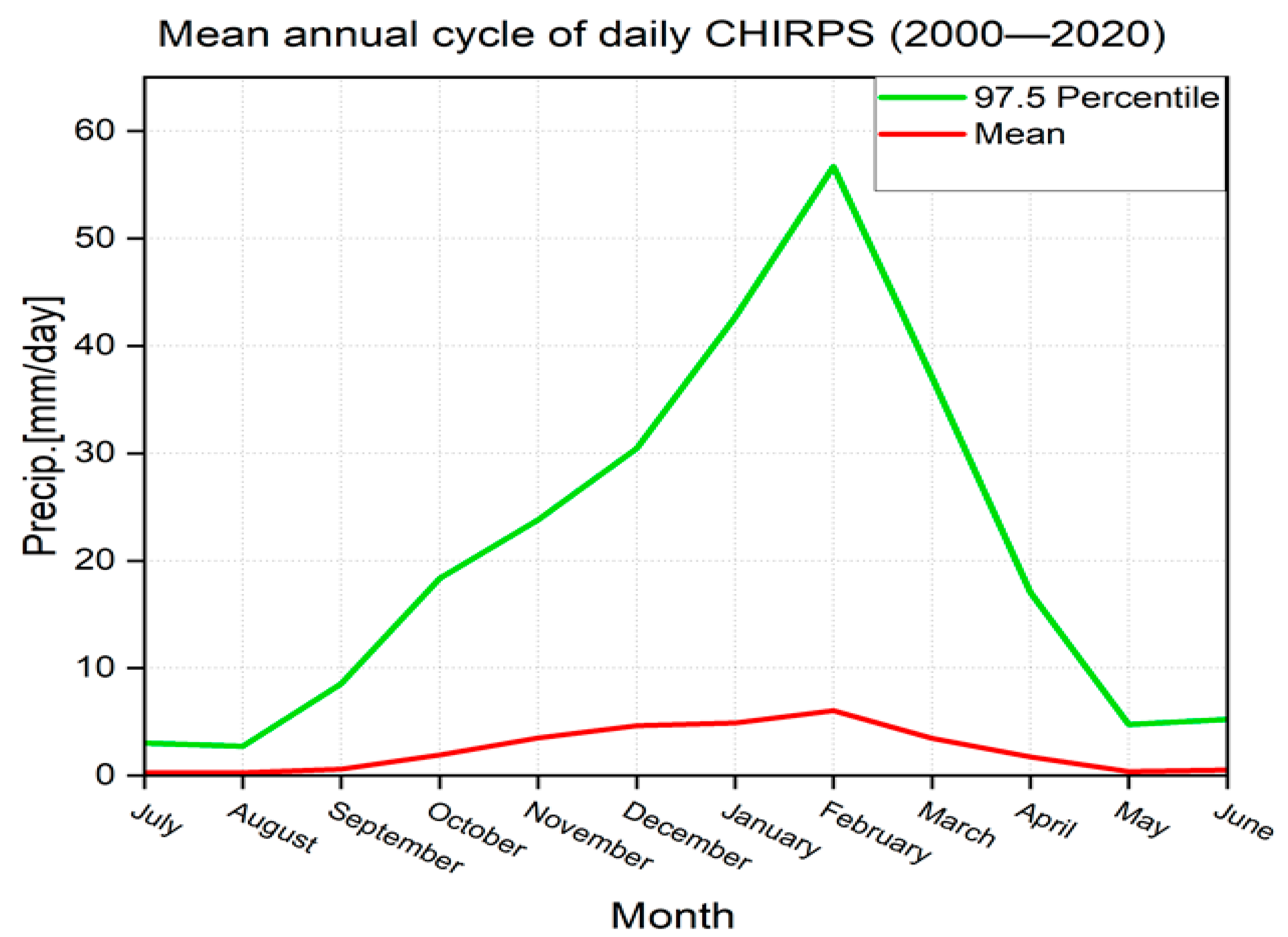
We focus on the country’s northern Limpopo province which receives most rainfall during the austral summer months [
15,
16], but for which the rainy season may extend from October to April. The main source of rainfall during this period is associated with moisture flux inflow mainly from the warm southwest Indian Ocean [
17]. Most of the extreme rainfall events over the region are attributed to rain-bearing weather systems such as cloud bands, tropical lows, mesoscale convective complexes and cut-off lows [
16]. Cloud bands form along tropical-temperate troughs (TTTs) that extend from the tropics to the mid-latitudes and produce nearly half of the seasonal rainfall over the summer rainfall region of South Africa [
18]. Slow moving cloud bands can dump heavy rainfall as they propagate eastwards through Limpopo towards Madagascar via the Mozambique Channel. The occasional landfall of tropical cyclones (identified as tropical lows over land) over southern Mozambique during the late summer is also linked to heavy rainfall and flooding in the province.
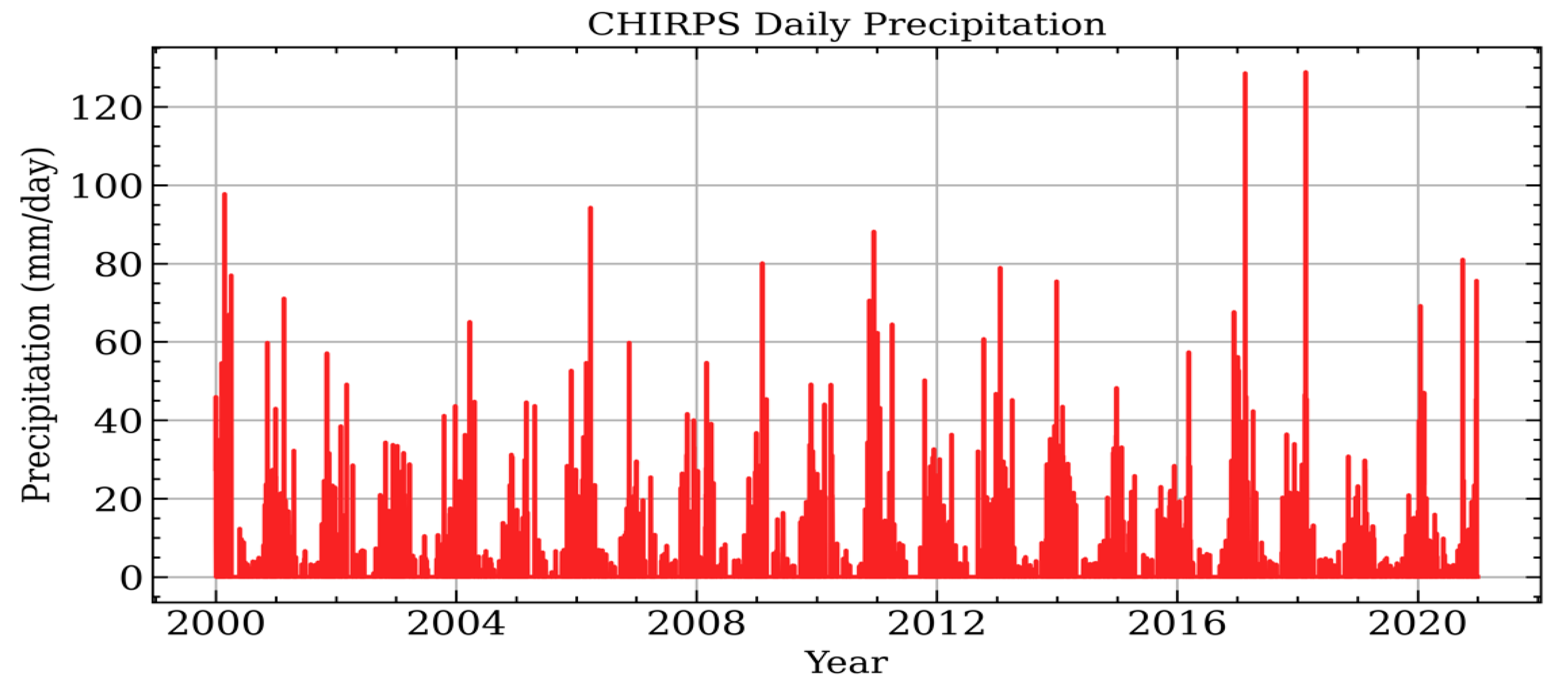
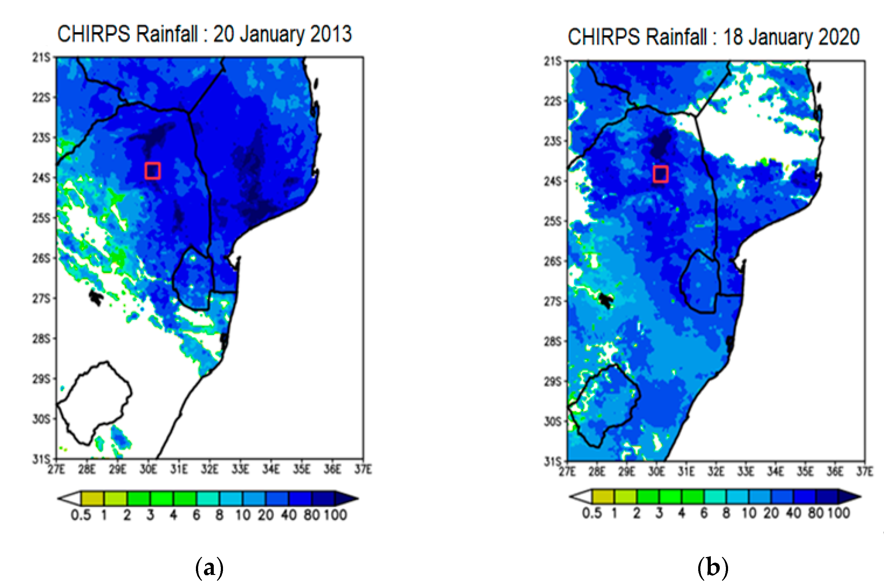
Floods due to ex-tropical cyclone Eline in 2000 and continental tropical lows in 2011, 2013 and 2014 have raised various concerns regarding flood vulnerability and preparedness in South Africa’s north-eastern interior. A more recent flood event occurred in Thohoyandou, northeast of South Africa during February 2019 after extreme precipitation (~300 mm/4 h) associated with a major cloud band [
15]. A nearby shopping mall was inundated with flood waters such that some vehicles were stagnated, raising concerns of poor siting and drainage. It was found that the interaction of a low-level jet with a nearby mountain range compounded the heavy rainfall and flooding in the area [
15]. Thus, this region is highly vulnerable to flooding from extreme rainfall, which may be exacerbated by climate change. It is also in the Limpopo Province that climate change models project a strong signal of warming in the future climate, e.g., [
19,
20]. The latest projections from the Intergovernmental Panel on Climate Change (IPCC) Assessment Report Six suggest (with high confidence) increased frequency of heavy precipitation over South Africa in future [
20].
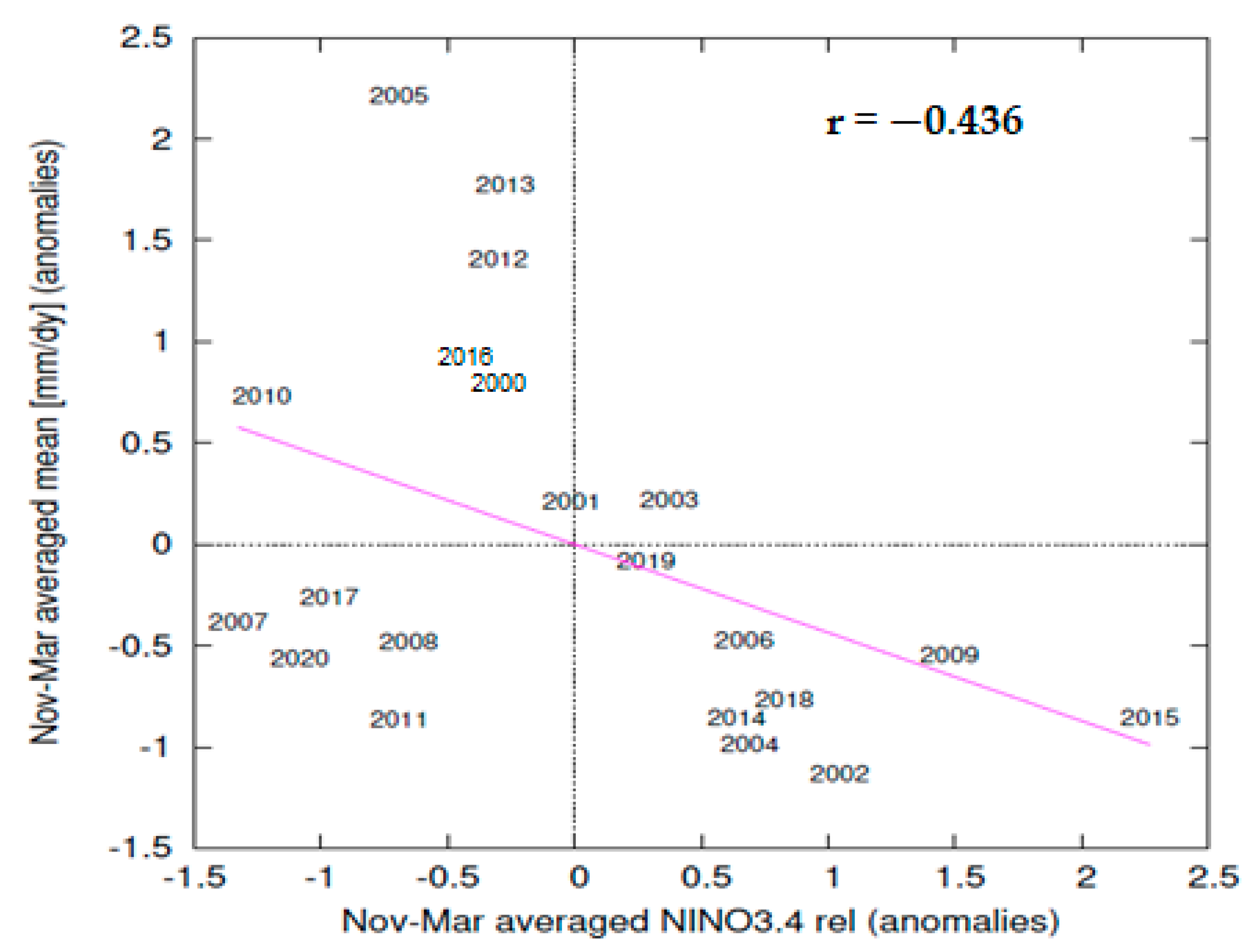
From season to season, the climate of South Africa’s Limpopo Province is also influenced by remote phenomena from hot spots in the Indian and Pacific Oceans. The El Niño Southern Oscillation (ENSO) is a dominant phenomenon that regulates the occurrence of extreme events such as droughts, heat waves and floods in the region [
17,
21]. El Niño events over the equatorial Pacific Ocean are mostly linked to dry and hot austral summers over the northeastern interior of the country [
22,
23,
24]. During this time, fewer cloud bands form, leading to below normal rainfall over the southern African subcontinent [
15]. The circulation becomes largely anticyclonic characterized by subsidence induced a strong mid-troposheric Botswana High [
25]. In contrast, most La Niña events have been linked to positive rainfall anomalies in the region [
26], with enhanced moisture flux from the southwest Indian Ocean. Hence, the risk of flooding is enhanced during La Niña events in the northeast of South Africa. The occurrence of La Niña has also been linked to high/extreme streamflow events in several other regions in the tropics [
27,
28,
29], which increase the risk of riverine flooding. Due to its warm climate, the Limpopo Province is also vulnerable to climate-sensitive diseases such as malaria, which often peak after a flood event. After floods, ponds create conducive conditions for breeding of
Anopheles arabiensis mosquitoes, which are the common species transmitting malaria in the area [
30,
31]. Cholera outbreaks also occur in Limpopo following flood events as many rural communities do not have piped/reticulated water supply. Thus, flood events also put human health, lives and livelihoods at risk, as water-borne and vector-borne diseases become more likely. Tourism is a major economic activity in the province due to large areas of wildlife/game parks, including the renowned Kruger National Park and the Mapungubwe National Park. When floods occur, huge economic losses are incurred by the tourism sector mainly due to damage to infrastructure [
32].
As a consequence of the vulnerability of the Limpopo Province to weather and climate extremes, several studies have detailed flood vulnerabilities, water pollution, impacts and adaptation in the province, e.g., [
3,
32,
33,
34,
35,
36]. However, the majority of the literature has focused on the Luvuvhu River Catchment, which is a major sub-catchment of the Limpopo River. This study focuses on flood vulnerabilities in Mopani, a district of the Limpopo Province which has not received adequate research attention.
Although studies have tackled floods from various fields and perspectives in the region, a paucity of vulnerability assessments for rural settlements to flood hazards remains. Several local communities have been declared vulnerable to floods, but little is known about the extent of their vulnerability. Our study of floods in rural South Africa is motivated by these vulnerabilities. Several indices have been developed to assess/measure levels of flood vulnerability at different spatial scales towards flood hazard management [
37]. The more recent approaches have focused on geospatial techniques for vulnerability assessment [
37]. Several studies have defined vulnerability as a measure of potential harm to communities caused by a natural hazard, e.g., [
38,
39,
40,
41]. A number of quantitative flood vulnerability indices have been developed to investigate the extent of potential harm due to exposure, susceptibility and resilience [
42,
43,
44,
45,
46]. Tools and indicators have been documented linking theoretical concepts to strategy development, policies, decision making and adaptation [
9,
42] with all having unique and various responses to flood occurrences. This has been crucial for characterizing vulnerability indices and indicators relative to regions and focusing on physical, economic and social vulnerability [
47]. Our study combines analysis of rainfall extremes, remote sensing and geo-spatial techniques with a vulnerability assessment using a Flood Vulnerability Index (FVI) developed and detailed in Balica et al. [
42] and Balica and Wright [
48]. The FVI calculates a single number based on social, economic, environmental and physical components in the water resource system [
42].
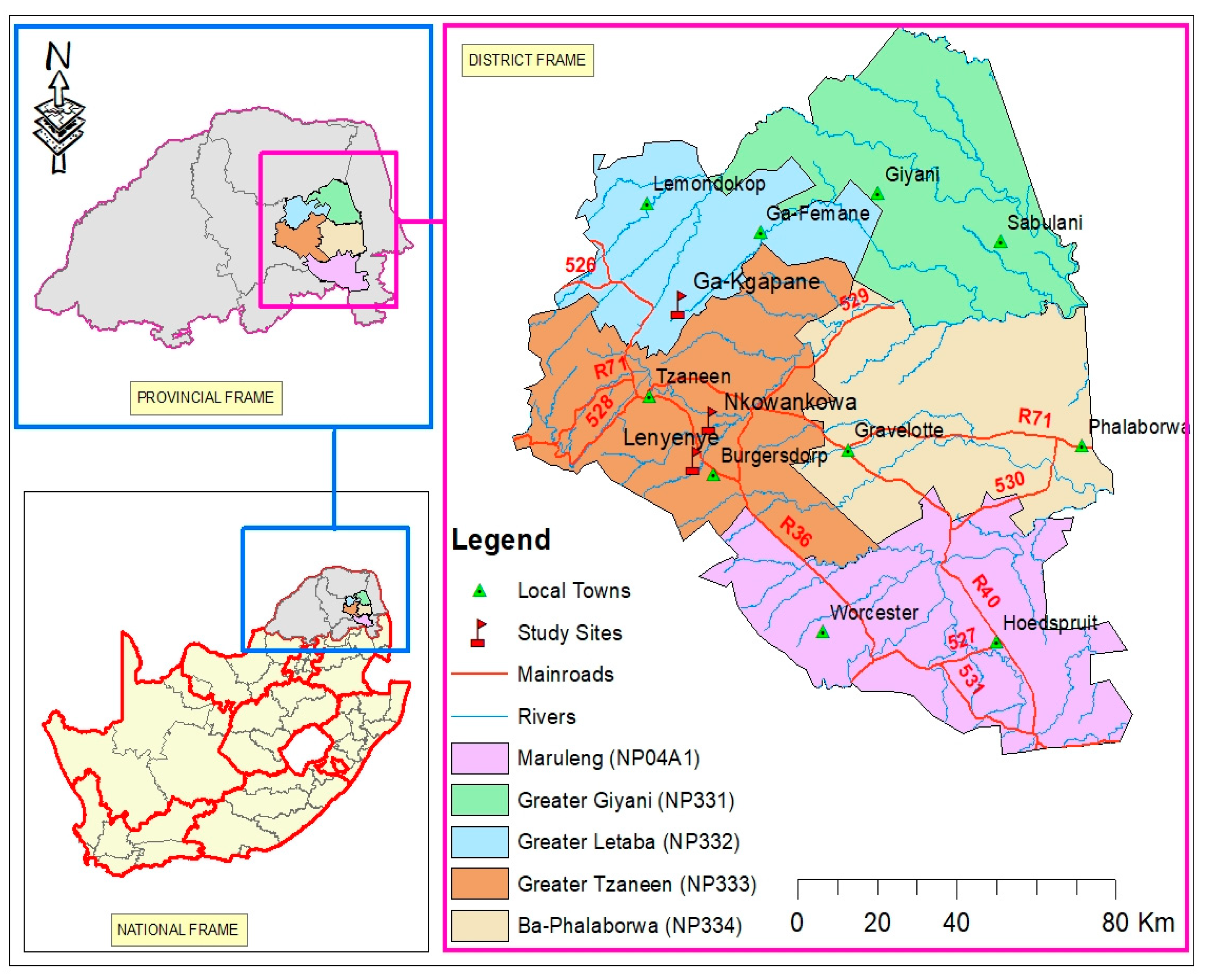
Thus, the main aim of this study is to (a) assess the nature and extent of flood vulnerability and (b) establish adaptation strategies employed by three selected rural communities in Mopani District Municipality affected by the flood hazard repeatedly in recent years. The remainder of the paper is structured as follows: a study area description precedes the data and methods section, and the results are presented as subsections. A discussion and recommendations for flood management are offered at the end.
4. Discussion
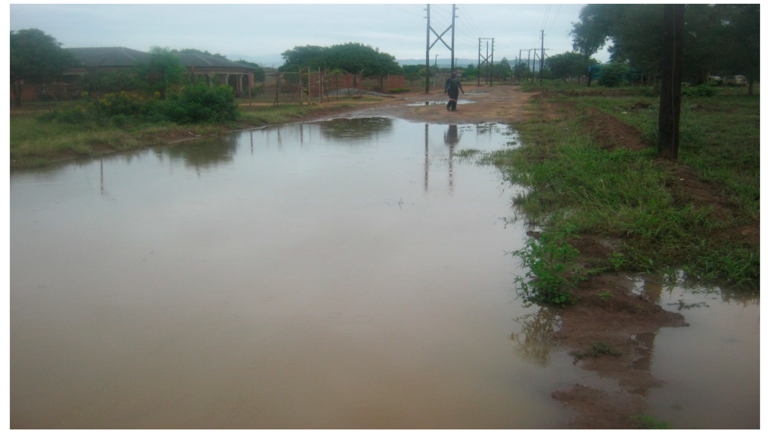
This study focused on understanding the risk and vulnerability and adaptation to flood hazards among rural communities in Greater-Tzaneen and Greater Letaba municipalities in South Africa’s northern Mopani District. We combined an analysis of vulnerability of the study sites to extreme rainfall and flooding, with physical, social and economic factors via a flood vulnerability index. In addition, resilience of a community is a key determinant of how vulnerable they may be, and this is particularly so in rural areas of South Africa; hence the focus of this study. We found that although extreme daily rainfall is rare, it occasionally occurs in this region, mainly during times of La Niña events when tropical storms and severe thunderstorms are more likely. Although there is a very small chance of tropical cyclones entering the Limpopo Province from the Mozambique Channel [
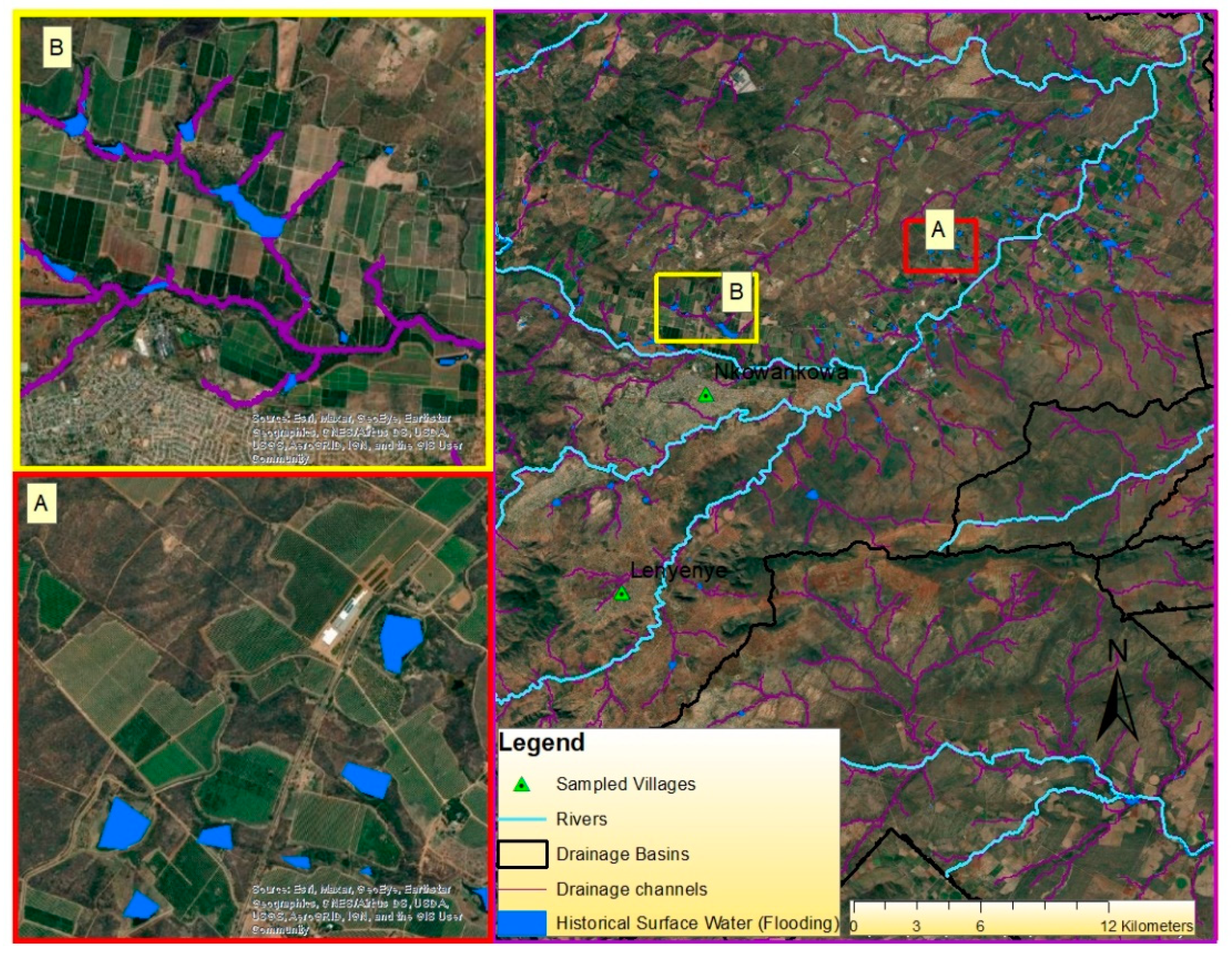
49], when they do, they cause widespread extreme rainfall and floods in the study region. In addition, poor drainage, lack of culverts or blockages in drainage channels were the other factors that compounded flood vulnerability. A geo-spatial analysis using remote sensing data revealed two types of flooding caused either by extreme rainfall or by poor drainage or blocked drainage channels. Thus, analyzing all these factors plays a significant role in flood management and adaptation to prevent excessive damage and loss of lives and livelihoods in future.
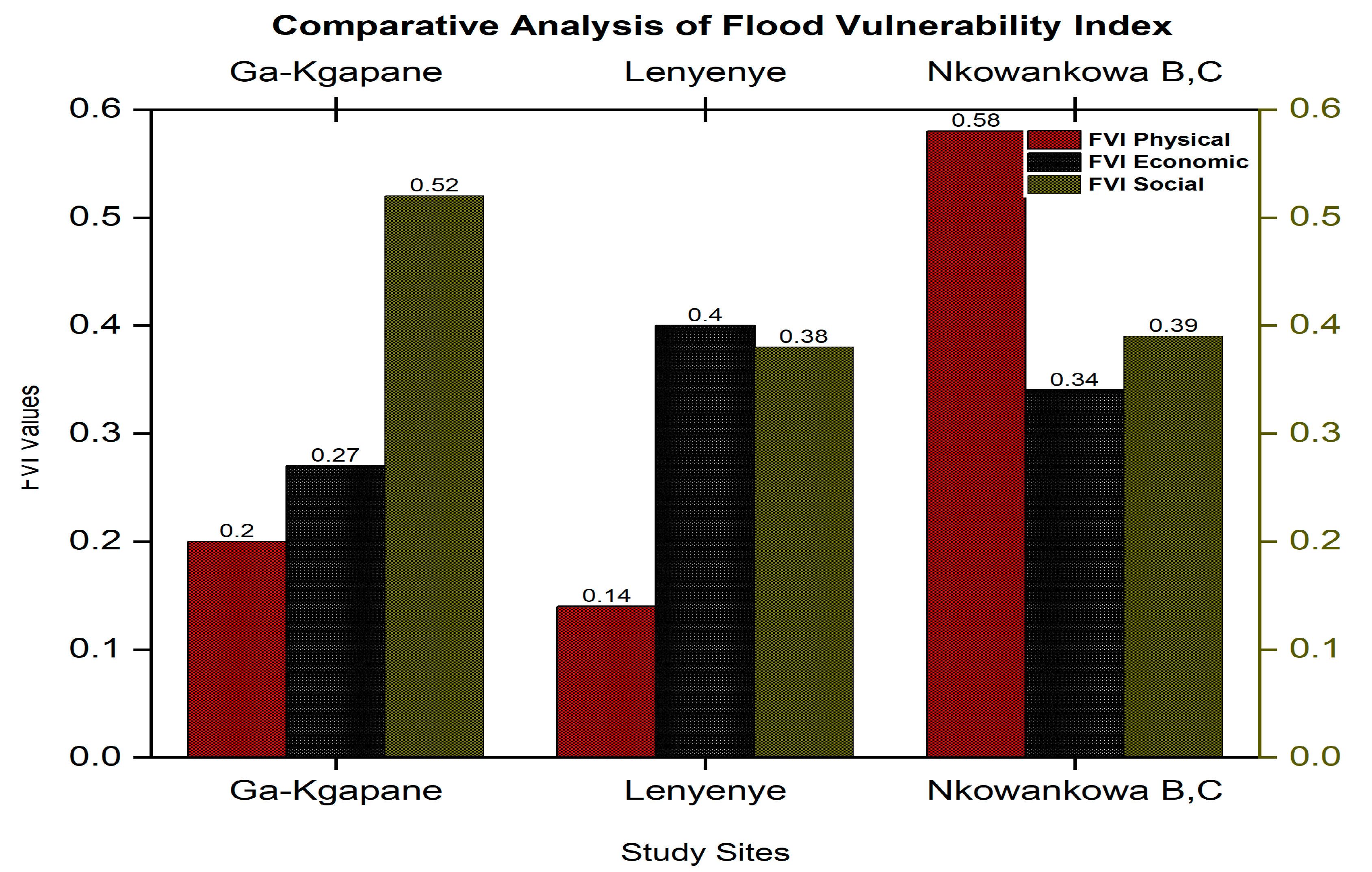
From the field survey, we calculated the FVI [
42] and found that the overall (social, economic and physical dimensions) level of flood vulnerability in the three rural settlements is ‘vulnerability to floods’. This level is considered a medium-level vulnerability such that the area/community can recover from flood damage in months [
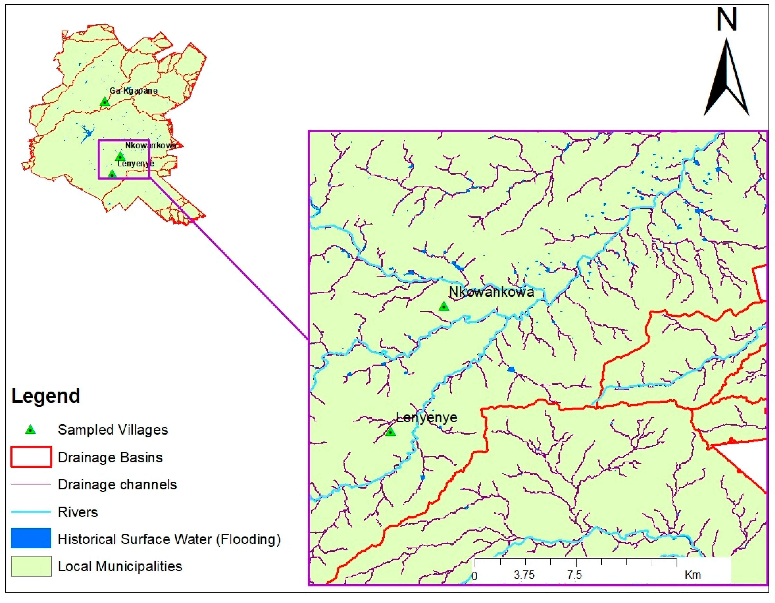
47]. However, the individual components of the FVI reflected different contributors to vulnerability levels across the three sites. Nkowankowa Section B and C had a higher vulnerability than the other two locations in the physical component because of its flat terrain and poor drainage. It is also nearer to the escarpment where rainy days are more regular. Lenyenye had the higher vulnerability to floods in the economic dimension mainly due to its high unemployment or poor wages, whereas Ga-Kgapane Masakaneng was more vulnerable in the social dimension due to low education levels and lack of awareness/preparedness. By rank, Nkowankowa Section and C was more vulnerable to floods (FVI = 0.40) than both Lenyenye (FVI = 0.34) and Ga-Kgapane Masakaneng (FVI = 0.34). Topography should be considered in Nkowankowa Section B and C during planning for the construction of future infrastructure, buildings and other development activities, as plain or flat slope areas are very prone to floods, whereas high elevations areas are free from floods but not flooding [
79]. Well-drained gravel roads can also mitigate ponding or flooding on roads, often disrupting movements of people for social and economic activities.
Vulnerability studies can be complicated. Vulnerability is a concept that is incomplete without assessing the capacity of individuals to resist the impacts of floods [
42]. There is a strong link between the components of vulnerability, as they do not operate or function independently of each other. The best means of conducting a comprehensive vulnerability study is by including all these components. Individuals can have a similar socio-economic status and physical exposure but employ different coping/adaptation strategies. Although this study dealt with historical and present-day flood vulnerabilities in Mopani District, projections of future vulnerabilities under climate change are even more important. Moreover, focusing on regional sensitivity, adaptive capacity and local exposure is critical in understanding local vulnerabilities and flood-related impacts [
80]. This helps the policy and decision makers, and civil protection and disaster managers, to know exactly where to concentrate and invest to deal with risk and hazards.
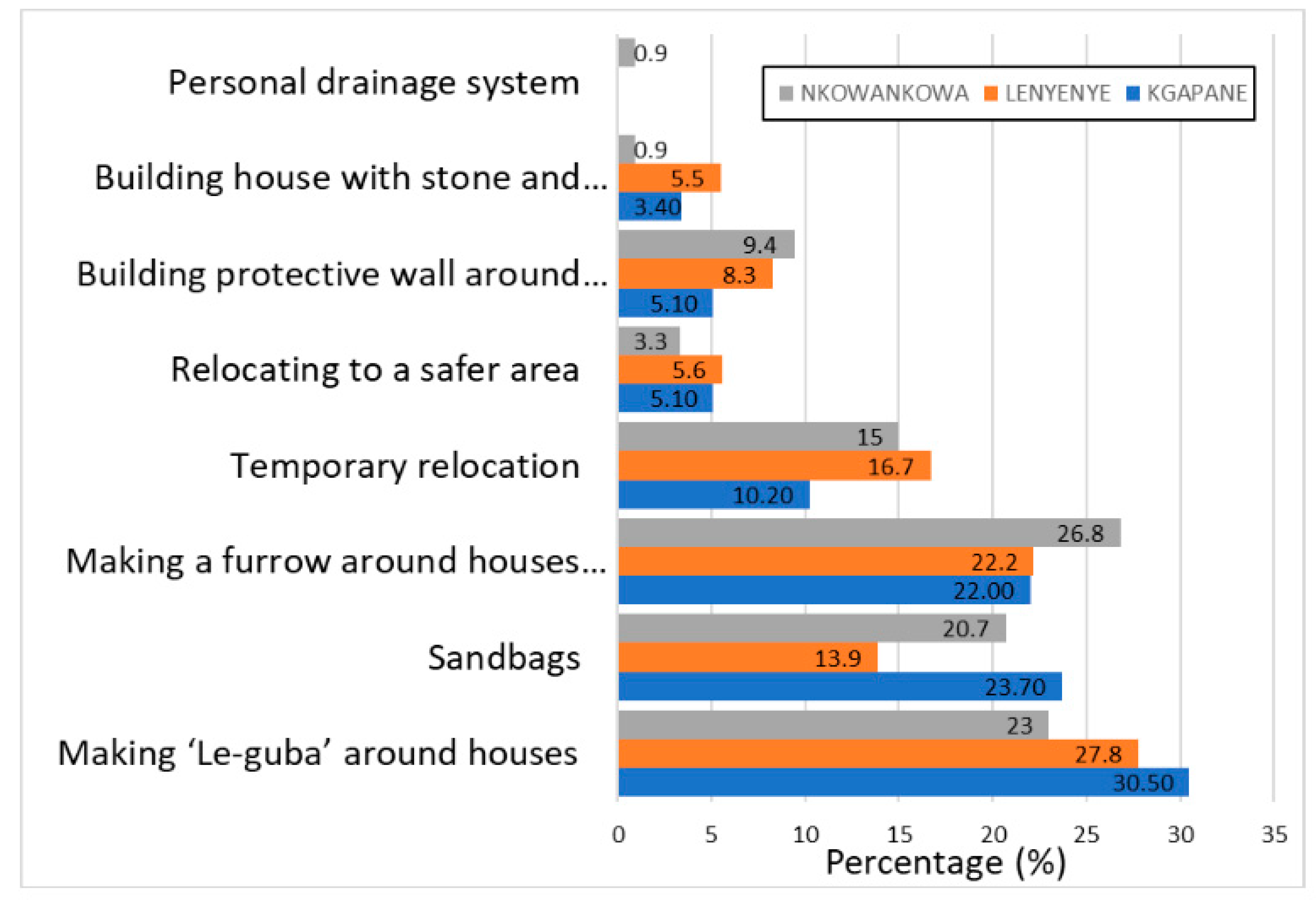
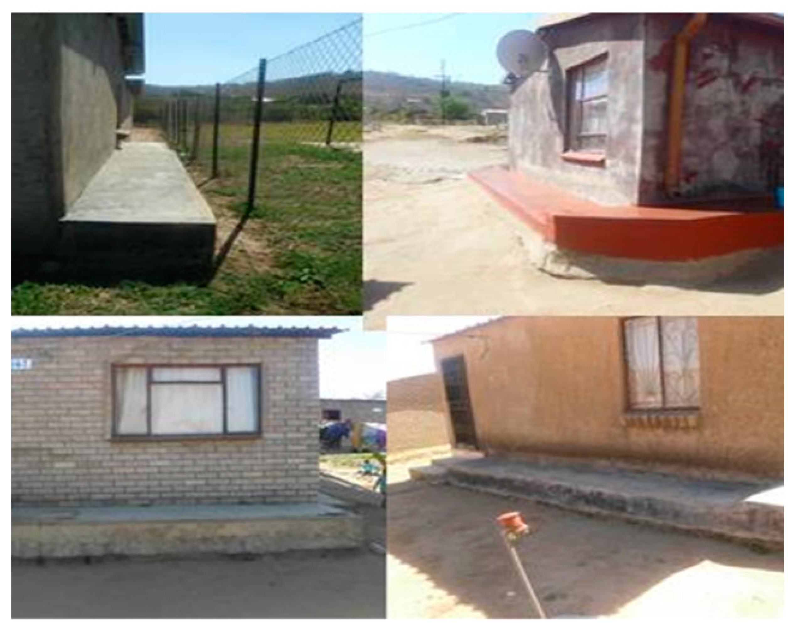
Relevant and affordable adaptation strategies/actions are required to match the vulnerability levels of each area and its components. In addition, impacts of floods experienced over a region may influence local adaptation choices [
81] with rural communities having high exposure, risk and minimal ability to recover. We found that the three study sites employed a variety of common adaptation strategies/actions to deal with the flood problem. Some strategies were more long-term, such as constructing a ‘Le-guba’, whereas others were short-term, such as temporary relocation, perhaps to higher ground. Issues of poor siting and quality of RDP houses, historical inequalities and population growth compound flood management in the region.
As the risk from floods increases, there is an urgent need to improve methods in decision support systems towards an effective early warning system, e.g., [
48]. Accurate weather forecasts of extreme precipitation are crucial, while ensuring that weather warnings reach rural communities in a timely manner in order to protect lives, livelihoods and property. Another way to reduce risk is through implementation of a raft of improved and sustainable infrastructure maintenance regimes, with future developments focused on areas less prone to flooding [
15].
There is a paucity of vulnerability assessments of rural settlements, such as those in Mopani District, where community livelihoods depend on natural resources and rain-fed subsistence agriculture, compounding their vulnerability compared to urban settlements. Despite being focused on the local scale, the findings of this study contribute to understanding the various factors that may affect vulnerability of similar rural communities to flood hazards. This is in addition to historical challenges such as lack of water supply infrastructure and good roads.


 ,
, 


