
Mapping Groundwater Potential Zones Using a Knowledge-Driven Approach and GIS Analysis

Abstract
:1. Introduction
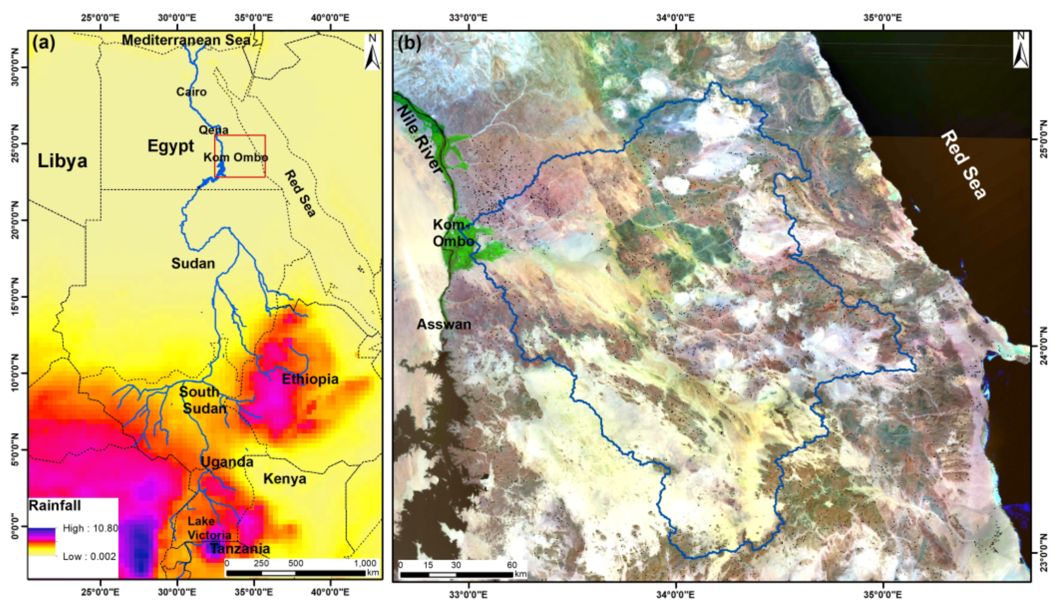
2. Study Area
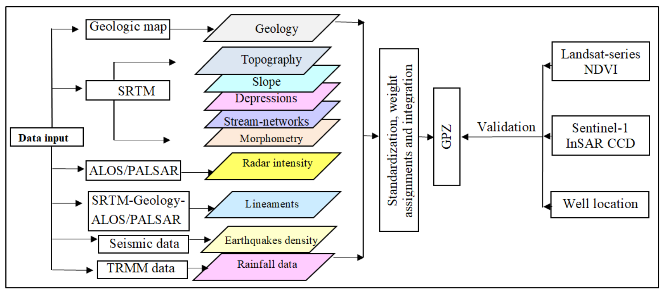
3. Data Used and Methods
4. Results
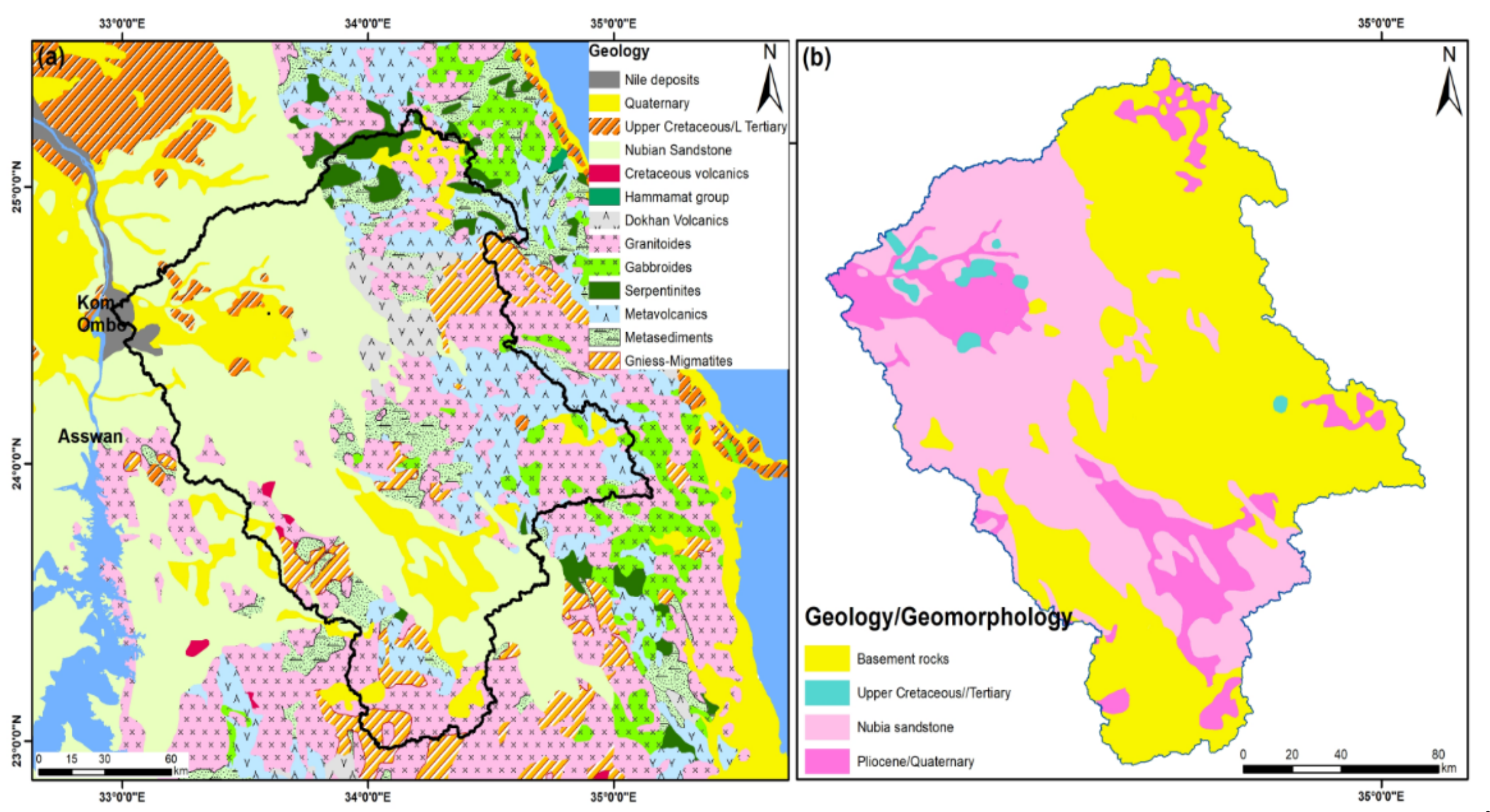
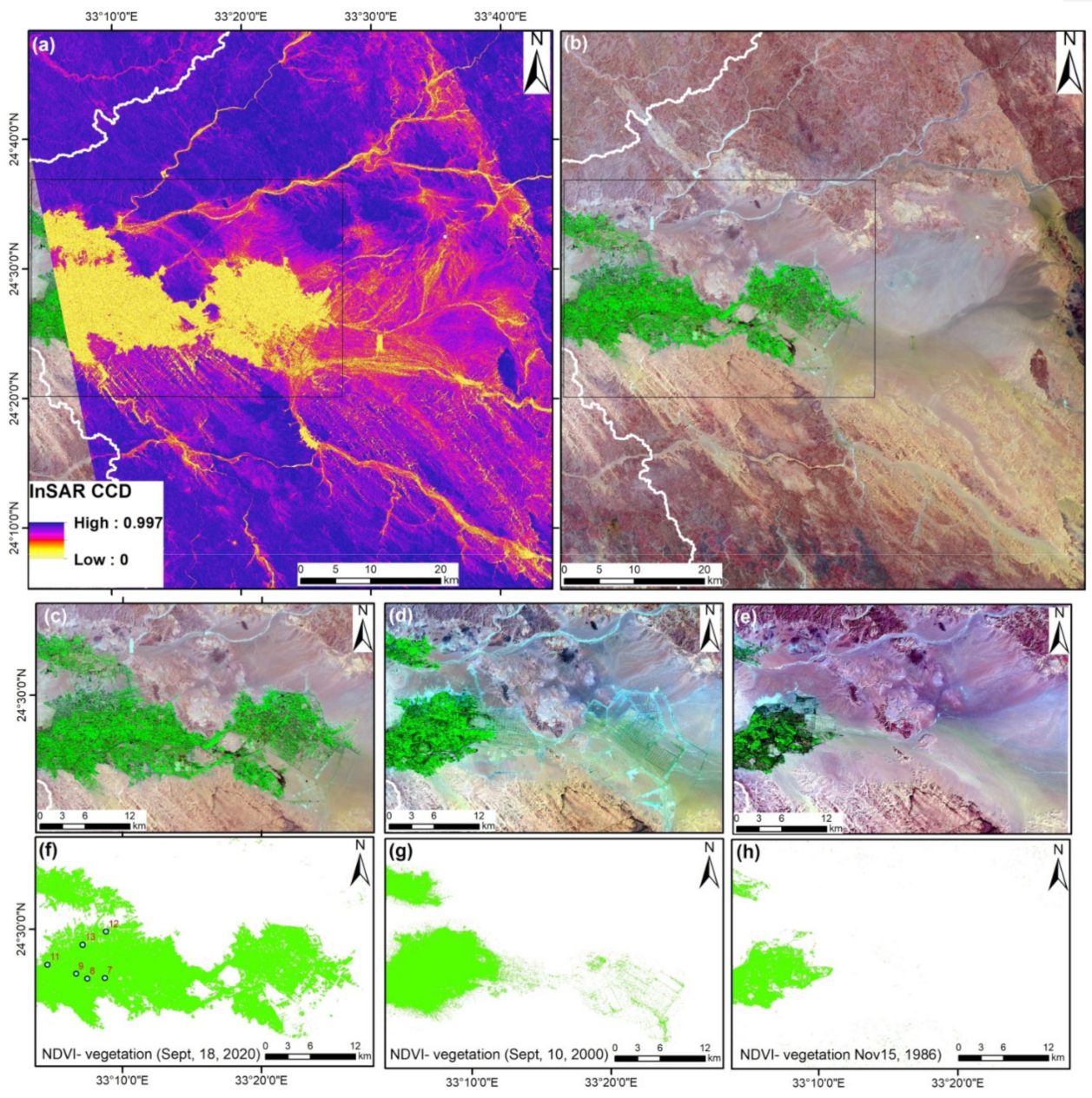
4.1. Geology/Geomorphology
4.2. Topography
4.3. Slope
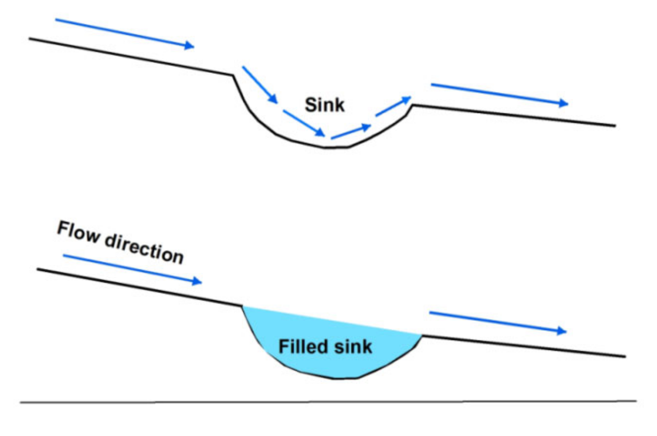
4.4. Depressions/Sinks
4.5. Stream-Networks
4.6. Morphometric Characteristics (Runoff)
4.7. Radar Intensity
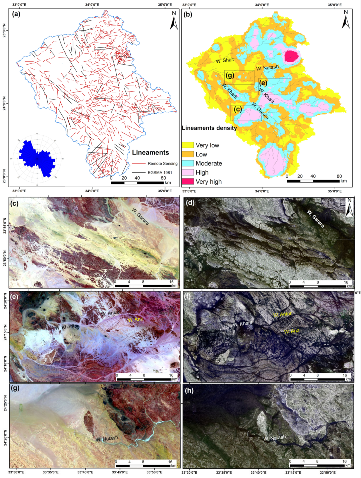
4.8. Lineaments
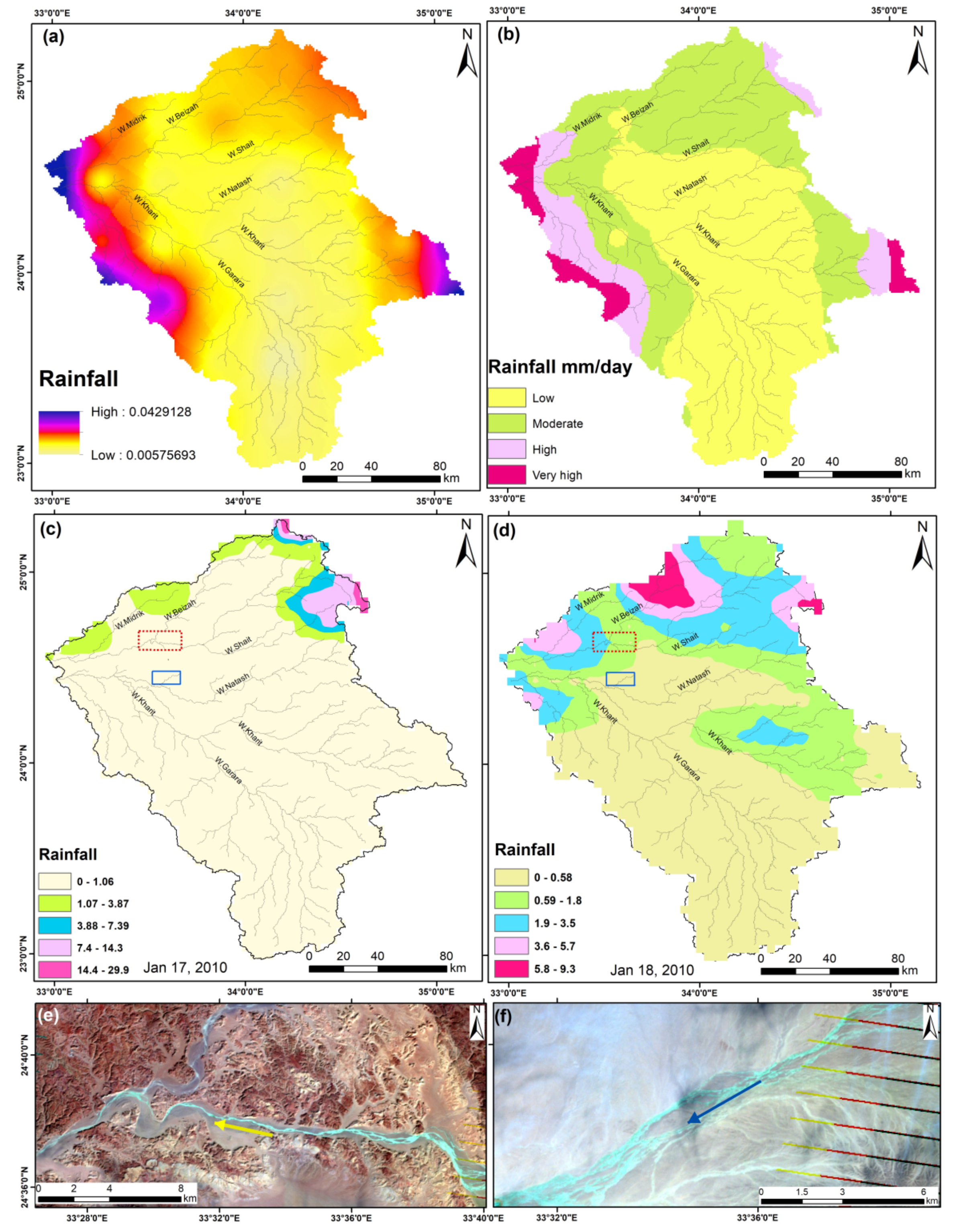
4.9. Rainfall Data (TRMM)
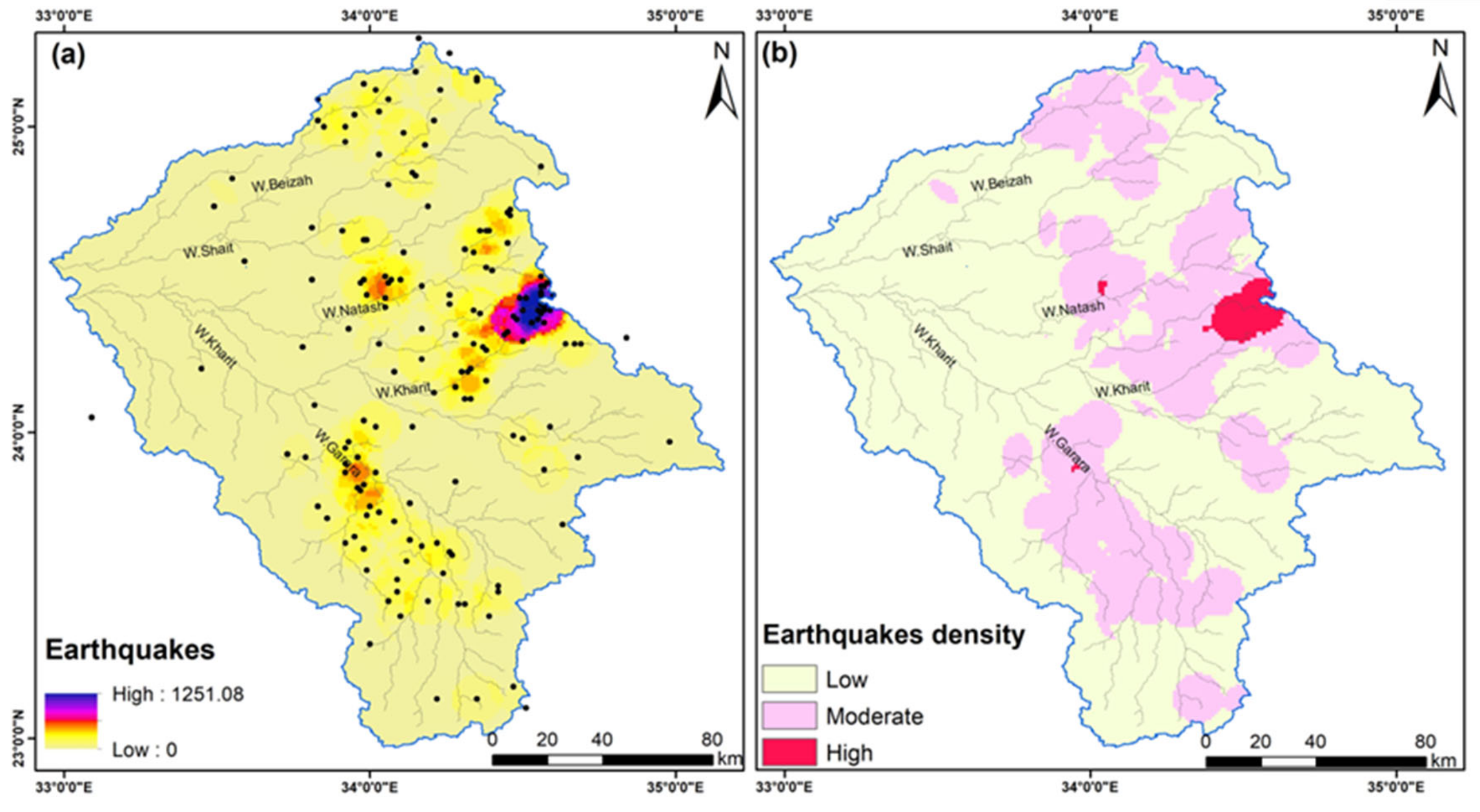
4.10. Earthquake (Seismicity)
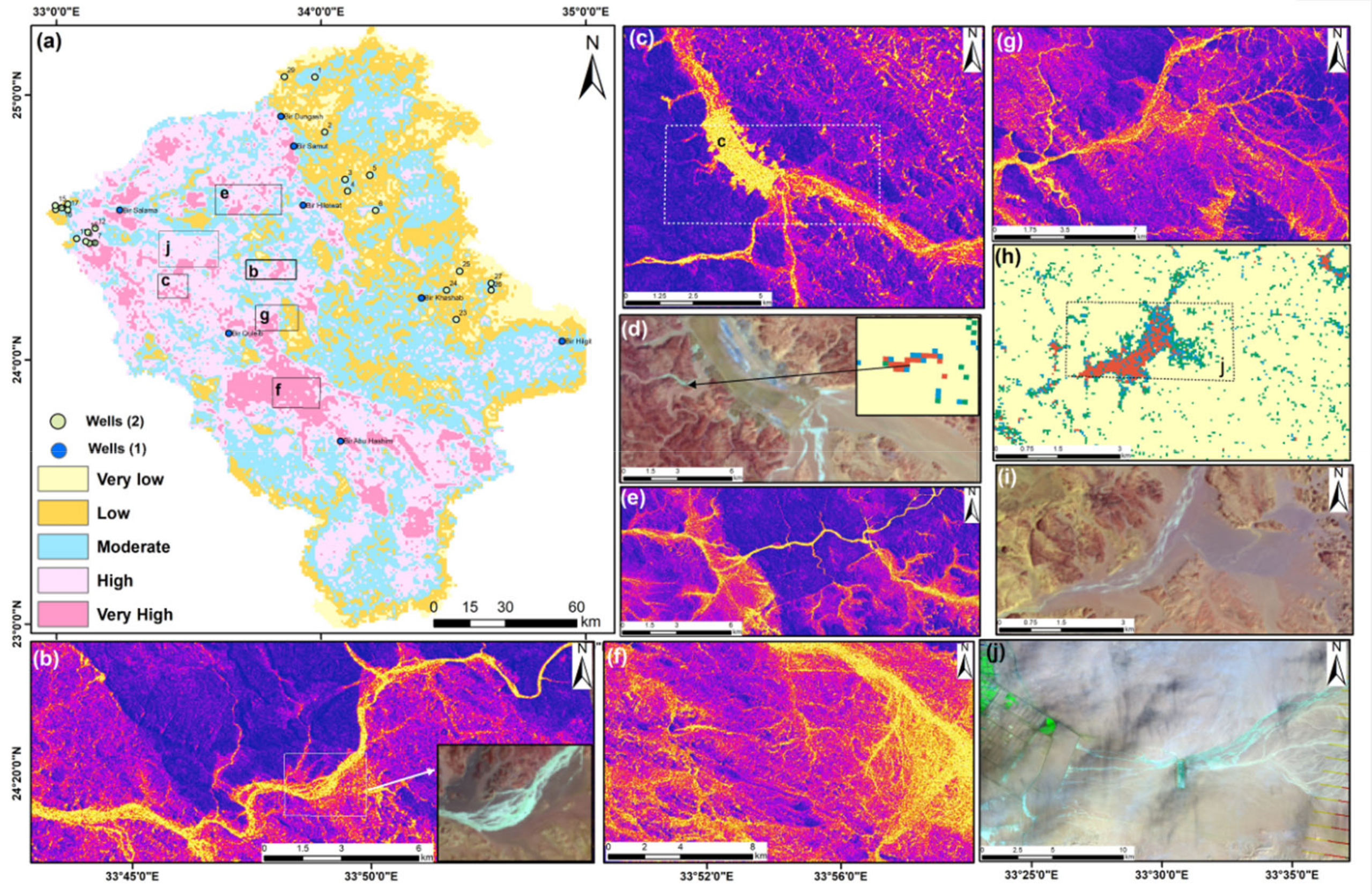
5. Groundwater Prospect Map
6. Discussion
7. Conclusions
Author Contributions
Funding
Institutional Review Board Statement
Informed Consent Statement
Data Availability Statement
Acknowledgments
Conflicts of Interest
References
- Benjmel, K.; Amraoui, F.; Boutaleb, S.; Ouchchen, M.; Tahiri, A.; Touab, A. Mapping of Groundwater Potential Zones in Crystalline Terrain Using Remote Sensing, GIS Techniques, and Multicriteria Data Analysis (Case of the Ighrem Region, Western Anti-Atlas, Morocco). Water 2020, 12, 471. [Google Scholar] [CrossRef] [Green Version]
- Abdelkareem, M.; El-Baz, F.; Askalany, M.; Akawy, A.; Ghoneim, E. Groundwater prospect map of Egypt’s Qena Valley using data fusion. Int. J. Image Data Fusion 2012, 3, 169–189. [Google Scholar] [CrossRef]
- Prabhakar, A.; Tiwari, H. Land use and land cover effect on groundwater storage. Model. Earth Syst. Environ. 2015, 1, 45. [Google Scholar] [CrossRef] [Green Version]
- UNESCO. The United Nations World Water Development Report 2015: Water for a Sustainable World; UNESCO: Paris, France, 2015. [Google Scholar]
- Mukherjee, I.; Singh, U.K. Delineation of groundwater potential zones in a drought-prone semi-arid region of east India using GIS and analytical hierarchical process techniques. CATENA 2020, 194, 104681. [Google Scholar] [CrossRef]
- Achu, A.L.; Reghunath, R.; Thomas, J. Mapping of Groundwater Recharge Potential Zones and Identification of Suitable Site-Specific Recharge Mechanisms in a Tropical River Basin. Earth Syst. Environ 2020, 4, 131–145. [Google Scholar] [CrossRef]
- Hussein, H.; Conker, A.; Grand, M. Small is beautiful but not trendy: Understanding the allure of big hydraulic works in the Euphrates-Tigris and Nile waterscapes. Mediterr. Politics 2020. [Google Scholar] [CrossRef]
- Hussein, H. The Guarani Aquifer System, highly present but not high profile: A hydropolitical analysis of transboundary groundwater governance. Environ. Sci. Policy 2018, 83, 54–62. [Google Scholar] [CrossRef] [Green Version]
- Abdelkareem, M.; El-Baz, F. Analyses of optical images and radar data reveal structural features and predict groundwater accumulations in the central Eastern Desert of Egypt. Arab. J. Geosci. 2015, 8, 2653–2666. [Google Scholar] [CrossRef]
- Moubark, K.; Abdelkareem, M. Characterization and assessment of groundwater resources using hydrogeochemical analysis, GIS, and field data in southern Wadi Qena, Egypt. Arab. J. Geosci 2018, 11, 598. [Google Scholar] [CrossRef]
- Gaber, A.; Abdelkareem, M.; Abdelsadek, I.S.; Koch, M.; El-Baz, F. Using InSAR coherence for investigating the interplay of fluvial and aeolian features in arid lands: Implications for groundwater potential in Egypt. Remote. Sens. 2018, 10, 832. [Google Scholar] [CrossRef] [Green Version]
- Mallick, J.; Khan, R.A.; Ahmed, M.; Alqadhi, S.D.; Alsubih, M.; Falqi, I.; Hasan, M.A. Modeling groundwater potential zone in a semi-arid region of Aseer using fuzzy-AHP and geoinformation techniques. Water 2019, 11, 2656. [Google Scholar] [CrossRef] [Green Version]
- Abdalla, F.; Moubark, K.; Abdelkareem, M. Groundwater potential mapping using GIS, linear weighted combination techniques and geochemical processes identification, west of the Qena area, Upper Egypt. J. Taibah Univ. Sci. 2020, 14, 1350–1362. [Google Scholar] [CrossRef]
- Odeh, T.; Mohammad, A.H.; Hussein, H.; Ismail, M.; Almomani, T. Over-pumping of groundwater, northern Jordan: A conceptual model to analyze the effects of urbanization and agricultural activities on groundwater levels and salinity. Environ. Earth Sci. 2019, 78, 40. [Google Scholar] [CrossRef] [Green Version]
- Avtar, R.; Singh, C.K.; Shashtri, S.; Singh, A.; Mukherjee, S. Identification and analysis of groundwater potential zones in Ken–Betwa river linking area using remote sensing and geographic information system. Geocarto Int. 2010, 25, 379–396. [Google Scholar] [CrossRef]
- Murmu, P.; Kumar, M.; Lal, D.; Sonker, I.; Singh, S.K. Delineation of groundwater potential zones using geospatial techniques and analytical hierarchy process in Dumka district, Jharkhand, India. Groundw. Sustain. Dev 2019, 9, 100239. [Google Scholar] [CrossRef]
- Çelik, R. Evaluation of Groundwater Potential by GIS-Based Multicriteria Decision Making as a Spatial Prediction Tool: Case Study in the Tigris River Batman-Hasankeyf Sub-Basin, Turkey. Water 2019, 11, 2630. [Google Scholar] [CrossRef] [Green Version]
- Andualem, T.G.; Demeke, G.G. Groundwater potential assessment using GIS and remote sensing: A case study of Guna tana landscape, upper blue Nile Basin, Ethiopia. J. Hydrol. Reg. Stud. 2019, 24, 100610. [Google Scholar] [CrossRef]
- Kumar, A.; Mondal, N.C.; Ahmed, S. Identification of Groundwater Potential Zones Using RS, GIS and AHP Techniques: A Case Study in a Part of Deccan Volcanic Province (DVP), Maharashtra, India. J. Indian Soc. Remote. Sens. 2020, 48, 497–511. [Google Scholar] [CrossRef]
- Al-Djazouli, M.O.; Elmorabiti, K.; Rahimi, A.; Amellah, O.; Fadil, O.A.M. Delineating of groundwater potential zones based on remote sensing, GIS and analytical hierarchical process: A case of Waddai, eastern Chad. GeoJournal 2020. [Google Scholar] [CrossRef]
- Berhanu, K.G.; Hatiye, S.D. Identification of Groundwater Potential Zones Using Proxy Data: Case study of Megech Watershed, Ethiopia. J. Hydrol. Reg. Stud. 2020, 28, 100676. [Google Scholar] [CrossRef]
- Ghosh, D.; Mandal, M.; Banerjee, M.; Karmakar, M. Impact of hydro-geological environment on availability of groundwater using analytical hierarchy process (AHP) and geospatial techniques: A study from the upper Kangsabati river basin. Groundw. Sustain. Dev. 2020, 11, 100419. [Google Scholar] [CrossRef]
- Lentswe, G.B.; Lentswe, M. Delineation of potential groundwater recharge zones using analytic hierarchy process-guided GIS in the semi-arid Motloutse watershed, eastern Botswana. J. Hydrol. Reg. Stud. 2020, 28, 100674. [Google Scholar] [CrossRef]
- Abdelkareem, M. Targeting flash flood potential areas using remotely sensed data and GIS techniques. Nat. Hazards 2017, 85, 19–37. [Google Scholar] [CrossRef]
- Abdelkareem, M.; El-Baz, F. Remote sensing of paleodrainage systems west of the Nile River, Egypt. Geocarto Int. 2017, 32, 541–555. [Google Scholar] [CrossRef]
- EGSMA. Geological Map of Egypt, Scale 1:2,000,000; The Egyptian Geological Survey and Mineral Authority: Cairo, Egypt, 1981. [Google Scholar]
- Said, R. The Geology of Egypt; A.A. Balkema: Rotterdam, The Netherlands; Brookfield, VT, USA, 1990; p. 734. [Google Scholar]
- Abdelkareem, M.; Abdalla, F.; Mohamed, S.Y.; El-Baz, F. Mapping paleohydrologic features in the arid areas of Saudi Arabia using remote-sensing data. Water 2020, 12, 417. [Google Scholar] [CrossRef] [Green Version]
- Abdelkareem, M.; Bamousa, A.O.; Hamimi, Z.; Kamal El-Din, G.M. Multispectral and RADAR images integration for geologic, geomorphic, and structural investigation in southwestern Arabian Shield, Al Qunfudhah area, Saudi Arabia. J. Taibah Univ. Sci. 2020, 14, 383–401. [Google Scholar] [CrossRef] [Green Version]
- O’Callaghan, J.F.; Mark, D.M. The extraction of drainage networks from digital elevation data. Comput. Vis. Graph. Image Process. 1984, 28, 323–344. [Google Scholar] [CrossRef]
- Abdelkareem, M.; Gaber, A.; Abdalla, F.; El-Din, G.K. Use of optical and radar remote sensing satellites for identifying and monitoring active/inactive landforms in the driest desert in Saudi Arabia. Geomorphology 2020, 362, 107197. [Google Scholar] [CrossRef]
- Havivi, S.; Amir, D.; Schvartzman, I.; August, Y.; Maman, S.; Rotman, S.R.; Blumberg, D.G. Mapping dune dynamics by InSAR coherence. Earth Surf. Process. Landf. 2018, 43, 1229–1240. [Google Scholar] [CrossRef]
- Derauw, D. Phase unwrapping using coherence measurements. In Proceedings of the SPIE 2584, Synthetic Aperture Radar and Passive Microwave Sensing, Paris, France, 21 November 1995; pp. 319–324. [Google Scholar] [CrossRef]
- Beumier, C.; Closson, D.; Lacroix, V.; Milisavljevic, N.; Yvinec, Y. Mine Action-The Research Experience of the Royal Military Academy of Belgium; InTechOpen: London, UK, 2017; p. 290. [Google Scholar]
- Bonham-Carter, G.F. Geographic Information Systems for Geoscientists: Modelling with GIS; Pergamon Press: Oxford, UK, 1994; p. 398. [Google Scholar]
- Carranza, E.J.M. Geochemical Anomaly and Mineral Prospectivity Mapping in GIS; Elsevier B.V: Amsterdam, The Netherlands, 2008. [Google Scholar]
- Voogd, J.H. Multicriteria Evaluation for Urban and Regional Planning. Ph.D. Thesis, Delftsche Uitgevers Maatschappij, Delft, The Netherlands, 1982. [Google Scholar] [CrossRef]
- Selvarani, A.G.; Maheswaran, G.; Elangovan, K. Identification of Artificial Recharge Sites for Noyyal River Basin Using GIS and Remote Sensing. J. Indian Soc. Remote Sens. 2017, 45, 67–77. [Google Scholar] [CrossRef]
- Yeh, H.-F.; Cheng, Y.-S.; Lin, H.-I.; Lee, C.-H. Mapping groundwater recharge potential zone using a GIS approach in Hualian River, Taiwan. Sustain. Environ. Res. 2016, 26, 33–43. [Google Scholar] [CrossRef] [Green Version]
- Pande, C.B.; Khadri, S.F.R.; Moharir, K.N.; Patode, R.S. Assessment of groundwater potential zonation of Mahesh River basin Akola and Buldhana districts, Maharashtra, India using remote sensing and GIS techniques. Sustain. Water Resour. Manag. 2018, 4, 965–979. [Google Scholar] [CrossRef]
- Doctor, D.H.; Young, J.A. An evaluation of automated GIS tools for delineating karst sinkholes and closed depressions from 1-meter LIDAR-derived digital elevation data. In Proceedings of the 13th Multidisciplinary Conference on Sinkholes and the Engineering & Environmental Impacts of Karst, Carslbad, NM, USA, 6–10 May 2013. [Google Scholar]
- Magesh, N.S.; Chandrasekar, N.; Soundranayagam, J.P. Delineation of groundwater potential zones in Theni district, Tamil Nadu, using remote sensing, GIS and MIF techniques. Geosci. Front. 2012, 3, 189–196. [Google Scholar] [CrossRef] [Green Version]
- Abdelkareem, M. Space Data and GIS Applications for Arid Region; South Valley University: Wadi Qena, Egypt, 2012; p. 251. [Google Scholar]
- El Bastawesy, M.; Faid, A.; Gammal, E.S.E. The Quaternary development of tributary channels to the Nile River at Kom Ombo area, Eastern Desert of Egypt, and their implication for groundwater resources. Hydrol. Process. 2010, 24, 1856–1865. [Google Scholar] [CrossRef]
- Zebker, H.A.; Rosen, P.; Hensley, S.; Mouginis-Mark, P.J. Analysis of active lava flows on Kilauea volcano, Hawaii, using SIR-C radar correlation measurements. Geology 1996, 24, 495–498. [Google Scholar] [CrossRef] [Green Version]
- Abdelsalam, M.G.; Stern, R.J.; Berhane, W.G. Mapping gossans in arid regions with Landsat TM and SIR-C images: The Beddaho Alteration Zone in northern Eritrea. J. Afr. Earth Sci. 2000, 30, 903–916. [Google Scholar] [CrossRef]
- Al-Ruzouq, R.; Shanableh, A.; Yilmaz, A.G.; Idris, A.; Mukherjee, S.; Khalil, M.A.; Gibril, M.B.A. Dam Site Suitability Mapping and Analysis Using an Integrated GIS and Machine Learning Approach. Water 2019, 11, 1880. [Google Scholar] [CrossRef] [Green Version]
- Caine, J.S.; Forster, C.B. Fault Zone Architecture and Fluid Flow: Insights from Field Data and Numerical Modeling. In Faults and Subsurface Fluid Flow in the Shallow Crust. Geophysical Monograph 113; Haneberg, W.C., Mozley, P.S., Moore, J.C., Goodwin, L.B., Eds.; American Geophysical Union: Washington, DC, USA, 1999; pp. 101–127. [Google Scholar]
- Apaydin, A. Relation of tectonic structure to groundwater flow in the Beypazari region, NW Anatolia, Turkey. Hydrogeol. J. 2010, 18, 1343–1356. [Google Scholar] [CrossRef]
- Ganapuram, S.; Kumar, G.T.V.; Krishna, I.V.M.; Kahya, E.; Demirel, M.C. Mapping of groundwater potential zones in the Musi basin using remote sensing data and GIS. Adv. Eng. Softw. 2009, 40, 506–518. [Google Scholar]
- Sibson, R.H.; Rowland, J.V. Stress, fluid pressure and structural permeability in seismogenic crust, North Island, New Zealand. Geophys. J. Int. 2003, 154, 584–594. [Google Scholar] [CrossRef] [Green Version]
- Manga, M.; Beresnev, I.; Brodsky, E.E.; Elkhoury, J.E.; Elsworth, D.; Ingebritsen, S.E.; Mays, D.C.; Wang, C.-Y. Changes in permeability caused by transient stresses: Field observations, experiments, and mechanisms. Rev. Geophys. 2012, 50. [Google Scholar] [CrossRef]
- Mastrorillo, L.; Saroli, M.; Viaroli, S.; Banzato, F.; Valigi, D.; Petitta, M. Sustained post-seismic effects on groundwater flow in fractured carbonate aquifers in Central Italy. Hydrol. Process. 2020, 34, 1167–1181. [Google Scholar] [CrossRef] [Green Version]
- Wang, C.-Y.; Manga, M. New streams and springs after the 2014 Mw6.0 South Napa earthquake. Nat. Commun. 2015, 6, 7597. [Google Scholar] [CrossRef] [PubMed] [Green Version]
- Conoco, Geological Map of Egypt, Scale 1:500,000; The Egyptian General Petroleum Corporation: Cairo, Egypt, 1987.
- Emara, M.M.; El-Sabbah, M.M.B.; Gomaa, M.A.; Mohallel, S.A. Remarks on the Hydrogeochemistry of the Area Between Idfu and Aswan, Eastern Desert, Egypt. Aust. J. Basic Appl. Sci. 2012, 6, 483–496. [Google Scholar]
- Sandford, K.S. The Pliocene and Pleistocene Deposits of Wadi Qena and of the Nile Valley between Luxor and Assiut (QAU). Q. J. Geol. Soc. 1929, 85, 493–548. [Google Scholar] [CrossRef]
- Butzer, K.W.; Hansen, C.L. Desert and River in Nubia: Geomorphology and Prehistoric Environments at the Aswan Reservoir; University of Wisconsin Press: Madison, WI, USA, 1968; p. 562. [Google Scholar]
- Abdelkareem, M.; El-Baz, F. Evidence of drainage reversal in the NE Sahara revealed by space-borne remote sensing data. J. Afr. Earth Sci. 2015, 110, 245–257. [Google Scholar] [CrossRef]
- Abdelkareem, M.; Ghoneim, E.; El-Baz, F.; Askalany, M. New insight on paleoriver development in the Nile basin of the eastern Sahara. J. Afr. Earth Sci. 2012, 62, 35–40. [Google Scholar] [CrossRef]
- El-Baz, F. Sand accumulation and groundwater in the eastern Sahara. Int. Union of Geol. Sci. 1998, 21, 147–151. [Google Scholar] [CrossRef]
- Abdel Kreem, W.F.M. Chemical and Isotopic Investigation of Groundwater Aquifers in Idfu Region on the Fringes of Qena Governorate. Master’s Thesis, Cairo University, Cairo, Egypt, 2000; p. 137. [Google Scholar]
- Cammeraat, L.H.; Imeson, A.C. The evolution and significance of soil–vegetation patterns following land abandonment and fire in Spain. CATENA 1999, 37, 107–127. [Google Scholar] [CrossRef]
- Owuor, S.O.; Butterbach-Bahl, K.; Guzha, A.C.; Rufino, M.C.; Pelster, D.E.; Díaz-Pinés, E.; Breuer, L. Groundwater recharge rates and surface runoff response to land use and land cover changes in semi-arid environments. Ecol. Process. 2016, 5, 16. [Google Scholar] [CrossRef] [Green Version]


| Thematic Layer | Rank | Normalized Layer Weight (Wi) | Detailed Features/Subclasses | Subclass | Rank | Capability Value (CVi) (Feature Normalized Weight) | Area (%) |
|---|---|---|---|---|---|---|---|
| Lithology | 5 | (0.125) | Quaternary deposits | High | 4 | 0.4 | 13.68 |
| Nubian Sandstone | Moderate | 3 | 0.3 | 34.20 | |||
| Upper Cretaceous/L-Tertiary | Low | 2 | 0.2 | 0.87 | |||
| Basement rocks | Very low | 1 | 0.1 | 51.23 | |||
| Topography | 4 | (0.1) | 91–280 | Very high | 5 | 0.33 | 17.90 |
| 280–399 | high | 4 | 0.27 | 37.07 | |||
| 399–517 | Moderate | 3 | 0.20 | 31.85 | |||
| 517–744 | Low | 2 | 0.13 | 11.70 | |||
| 744–1710 | Very low | 1 | 0.07 | 1.50 | |||
| Slope | 4 | (0.1) | 0–2.46 (nearly level ) | Very high | 5 | 0.33 | 62.15 |
| 2.46–5.71 (gently sloping) | High | 4 | 0.27 | 24.48 | |||
| 5.71–11.06 (moderately sloping) | Moderate | 3 | 0.20 | 8.84 | |||
| 11.06–19.65 (strongly sloping) | Low | 2 | 0.13 | 3.33 | |||
| 19.65–50.84 (steep–very steep) | Very low | 1 | 0.07 | 1.18 | |||
| Sinks/ Depressions | 7 | (0.175) | −82 to −8 | Very high | 8 | 0.44 | 0.906 |
| −7.99 to −5 | Moderate | 6 | 0.33 | 1.73 | |||
| −4.99 to −2 | Low | 3 | 0.17 | 6.36 | |||
| −1.99 to 0 | Very low | 1 | 0.06 | 91.00 | |||
| Stream-networks | 5 | (0.125) | 58.73–83.74 | Very high | 5 | 0.33 | 7.48 |
| 48.80–58.37 | High | 4 | 0.27 | 76.17 | |||
| 40.51–48.80 | Moderate | 3 | 0.20 | 35.43 | |||
| 29.52–40.51 | Low | 2 | 0.13 | 22.89 | |||
| 5.14–29.52 | Very low | 1 | 0.07 | 8.03 | |||
| Runoff | 2 | 0.05 | 25.02–29.57 | Very high | 5 | 0.33 | 30.23 |
| 29.57–35.70 | High | 4 | 0.27 | 9.57 | |||
| 35.70–37.03 | Moderate | 3 | 0.20 | 28.87 | |||
| 37.03–39.71 | Low | 2 | 0.13 | 8.66 | |||
| 39.7–49.71 | Very low | 1 | 0.07 | 22.67 | |||
| Radar intensity | 4 | (0.1) | 0–26.98 | Very high | 5 | 0.33 | 26.85 |
| 26.98–55.47 | High | 4 | 0.27 | 27.36 | |||
| 55.47–112.43 | Moderate | 3 | 0.20 | 27.50 | |||
| 112.43–164.06 | Low | 2 | 0.13 | 11 | |||
| 164.06–255 | Very low | 1 | 0.07 | 7.25 | |||
| Lineaments | 4 | (0.1) | 51–79 | Very high | 5 | 0.33 | 0.963 |
| 32–50 | High | 4 | 0.27 | 12.74 | |||
| 22–31 | Moderate | 3 | 0.20 | 26.91 | |||
| 13–21 | Low | 2 | 0.13 | 35.40 | |||
| 0–12 | Very low | 1 | 0.07 | 23.97 | |||
| Rainfall | 3 | (0.075) | 0.238–0.04248 | High | 4 | 0.4 | 4.77 |
| 0.017317–0.023818 | Moderate | 3 | 0.3 | 9.99 | |||
| 0.0126213–0.017317 | Low | 2 | 0.2 | 36.44 | |||
| 0.00579–0.012613 | Very low | 1 | 0.1 | 49.09 | |||
| Earthquakes | 2 | 0.05 | 431.7–1251.08 | High | 3 | 0.5 | 1.36 |
| 93.21–431.74 | Low | 2 | 0.3 | 29.92 | |||
| 0–93.2 | Very low | 1 | 0.2 | 68.71 |
| Drainage | Basin Geometry | Drainage Texture | Relief Characteristics | |||||||||||||||
|---|---|---|---|---|---|---|---|---|---|---|---|---|---|---|---|---|---|---|
| Basin_NO | U | Nu | Lu (km) | Rb | A (km2) | P (km) | Lb | Rf | Re | Rt | Rc | Fs | Dd | If | Lg | Bh | Rh | Rn |
| 1 | 6 | 789 | 3812.494 | 4.852 | 8632.454 | 783.309 | 110.542 | 0.706 | 0.948 | 1.007 | 0.177 | 0.091 | 0.442 | 0.040 | 1.132 | 0.917 | 0.008 | 0.405 |
| 2 | 5 | 583 | 2654.584 | 4.728 | 6201.148 | 642.403 | 146.962 | 0.287 | 0.605 | 0.908 | 0.189 | 0.094 | 0.222 | 0.021 | 2.250 | 1.489 | 0.010 | 0.331 |
| 3 | 5 | 202 | 858.150 | 3.728 | 2065.566 | 458.404 | 83.668 | 0.295 | 0.613 | 0.441 | 0.124 | 0.098 | 0.415 | 0.041 | 1.203 | 0.836 | 0.010 | 0.347 |
| 4 | 4 | 123 | 494.358 | 5.263 | 1198.548 | 373.799 | 81.333 | 0.181 | 0.480 | 0.329 | 0.108 | 0.103 | 0.412 | 0.042 | 1.212 | 0.934 | 0.011 | 0.385 |
| 5 | 5 | 238 | 1061.780 | 3.919 | 2451.637 | 485.397 | 90.293 | 0.301 | 0.619 | 0.490 | 0.131 | 0.097 | 0.433 | 0.042 | 1.154 | 1.244 | 0.014 | 0.539 |
| 6 | 4 | 169 | 698.795 | 4.750 | 1602.815 | 407.931 | 99.911 | 0.161 | 0.452 | 0.414 | 0.121 | 0.105 | 0.436 | 0.046 | 1.147 | 0.965 | 0.010 | 0.421 |
| 7 | 4 | 95 | 373.053 | 3.684 | 984.171 | 298.645 | 72.078 | 0.189 | 0.491 | 0.318 | 0.139 | 0.097 | 0.379 | 0.037 | 1.319 | 0.248 | 0.003 | 0.094 |
| 8 | 4 | 82 | 442.687 | 7.667 | 1057.470 | 304.204 | 76.888 | 0.179 | 0.477 | 0.270 | 0.144 | 0.078 | 0.419 | 0.032 | 1.194 | 0.408 | 0.005 | 0.171 |
| 9 | 5 | 276 | 1269.512 | 3.934 | 2763.974 | 431.642 | 63.744 | 0.680 | 0.931 | 0.639 | 0.186 | 0.100 | 0.459 | 0.046 | 1.089 | 0.400 | 0.006 | 0.184 |
| 10 | 4 | 64 | 280.441 | 4.545 | 678.213 | 272.578 | 60.438 | 0.186 | 0.486 | 0.235 | 0.115 | 0.094 | 0.414 | 0.039 | 1.209 | 0.336 | 0.006 | 0.139 |
| 11 | 4 | 70 | 370.717 | 5.000 | 816.389 | 275.334 | 37.557 | 0.579 | 0.858 | 0.254 | 0.135 | 0.086 | 0.454 | 0.039 | 1.101 | 0.242 | 0.006 | 0.110 |
| Kom Ombo Basins | 6 | 2674 | 12316.567 | 4.869 | 28452.402 | 1536.954 | 241.677 | 0.487 | 0.788 | 1.740 | 0.151 | 0.094 | 0.433 | 0.041 | 1.155 | 1.633 | 0.007 | 0.707 |
| Basin_NO | Rb | Rf | Re | Rt | Rc | Fs | Dd | If | Lg | Bh | Rh | Rn | Σ of Runoff |
|---|---|---|---|---|---|---|---|---|---|---|---|---|---|
| 1 | 3.828 | 5.000 | 5.000 | 5.000 | 4.406 | 2.987 | 4.702 | 4.106 | 4.850 | 3.165 | 2.879 | 3.797 | 49.719 |
| 2 | 3.951 | 1.927 | 2.229 | 4.484 | 5.000 | 3.362 | 1.000 | 1.000 | 1.000 | 5.000 | 3.589 | 3.131 | 35.673 |
| 3 | 4.956 | 1.986 | 2.296 | 2.066 | 1.777 | 3.904 | 4.260 | 4.148 | 4.604 | 2.905 | 3.535 | 3.278 | 39.715 |
| 4 | 3.414 | 1.151 | 1.227 | 1.488 | 1.000 | 4.596 | 4.210 | 4.419 | 4.574 | 3.220 | 4.112 | 3.619 | 37.031 |
| 5 | 4.764 | 2.027 | 2.343 | 2.323 | 2.134 | 3.801 | 4.558 | 4.374 | 4.773 | 4.214 | 5.000 | 5.000 | 45.311 |
| 6 | 3.930 | 1.000 | 1.000 | 1.929 | 1.654 | 5.000 | 4.606 | 5.000 | 4.799 | 3.319 | 3.406 | 3.938 | 39.582 |
| 7 | 5.000 | 1.212 | 1.314 | 1.431 | 2.524 | 3.722 | 3.646 | 3.504 | 4.206 | 1.019 | 1.000 | 1.000 | 29.578 |
| 8 | 1.000 | 1.134 | 1.202 | 1.180 | 2.767 | 1.000 | 4.314 | 2.845 | 4.636 | 1.532 | 1.722 | 1.691 | 25.023 |
| 9 | 4.749 | 4.808 | 4.857 | 3.095 | 4.881 | 4.199 | 5.000 | 4.983 | 5.000 | 1.507 | 2.097 | 1.807 | 46.983 |
| 10 | 4.135 | 1.184 | 1.275 | 1.000 | 1.341 | 3.412 | 4.227 | 3.891 | 4.585 | 1.302 | 1.820 | 1.404 | 29.576 |
| 11 | 3.678 | 4.065 | 4.275 | 1.101 | 2.359 | 2.176 | 4.912 | 3.878 | 4.957 | 1.000 | 2.162 | 1.143 | 35.705 |
| GPZs | Weight | Area | Wells | |
|---|---|---|---|---|
| 1 | Very high | 39–72 | 10.34% | n = 13 (44.83%) |
| 2 | High | 72–86 | 29.71% | |
| 3 | Moderate | 86–97 | 30.75% | n = 12 (41.38%) |
| 4 | Low | 97–110 | 22.62% | n = 4 (13.79%) |
| 5 | Very low | 110–487 | 6.56% |
Publisher’s Note: MDPI stays neutral with regard to jurisdictional claims in published maps and institutional affiliations. |
© 2021 by the authors. Licensee MDPI, Basel, Switzerland. This article is an open access article distributed under the terms and conditions of the Creative Commons Attribution (CC BY) license (http://creativecommons.org/licenses/by/4.0/).
Share and Cite
Zhu, Q.; Abdelkareem, M. Mapping Groundwater Potential Zones Using a Knowledge-Driven Approach and GIS Analysis. Water 2021, 13, 579. https://doi.org/10.3390/w13050579
Zhu Q, Abdelkareem M. Mapping Groundwater Potential Zones Using a Knowledge-Driven Approach and GIS Analysis. Water. 2021; 13(5):579. https://doi.org/10.3390/w13050579
Chicago/Turabian StyleZhu, Qiande, and Mohamed Abdelkareem. 2021. "Mapping Groundwater Potential Zones Using a Knowledge-Driven Approach and GIS Analysis" Water 13, no. 5: 579. https://doi.org/10.3390/w13050579
APA StyleZhu, Q., & Abdelkareem, M. (2021). Mapping Groundwater Potential Zones Using a Knowledge-Driven Approach and GIS Analysis. Water, 13(5), 579. https://doi.org/10.3390/w13050579