
Coastal Modification in Relation to Sea Storm Effects: Application of 3D Remote Sensing Survey in Sanremo Marina (Liguria, NW Italy)

 ,
,  , , ,
, , ,  and
and 
Abstract
:1. Introduction
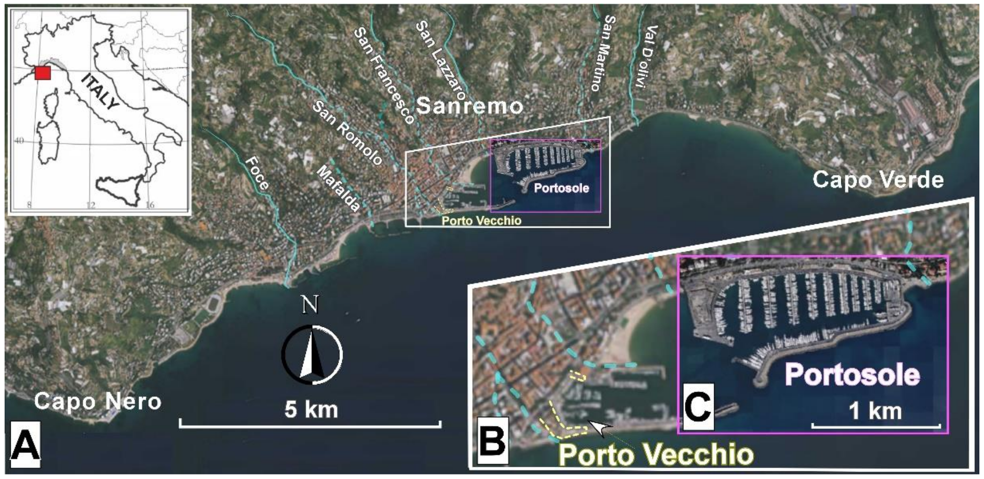
2. Study Area
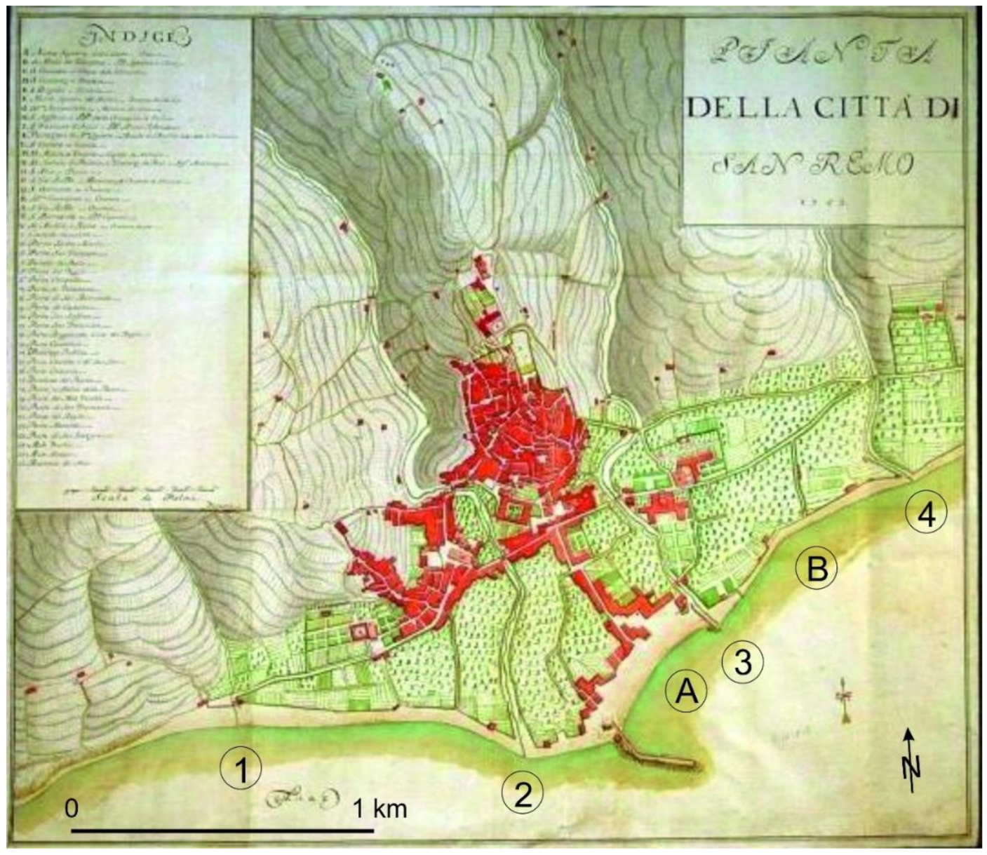
- Up to the middle of the 19th century, the coast was affected by a progradation of the beaches, thanks to the sedimentary input by the different watercourses and the erosional retreat of the sea cliffs. It is demonstrated by the historical map of Matteo Vinzoni [52], showing the former conditions of the coast in 1753 (Figure 2);
- After the second half of the 19th century, the beaches were generally affected by erosion, albeit with alternating phases of advancement and retreat. Since the beginning of the 20th century, to counteract the effects of sediments deficit connected to the port works on sediment transport, the construction of numerous defense works was necessary;
- Since 1965 up to the mid-seventies, several works of sea-embankments (reclamation area) and beach nourishment have been carried out;
- Between 1975 and 1980, the Portosole Marina was built between the Porto Vecchio (west) and the mouth of the San Martino stream (east). This has determined the current coastal layout, together with recent and further expansion and reinforcement work. The construction of Portosole caused the disappearance of pre-existing beaches, in erosion (about 13 m in the period 1944–1973) and protected by six groins. The artificial advancement of the coastline due to the construction of the infrastructures (techno-coast) was more than 350 m;
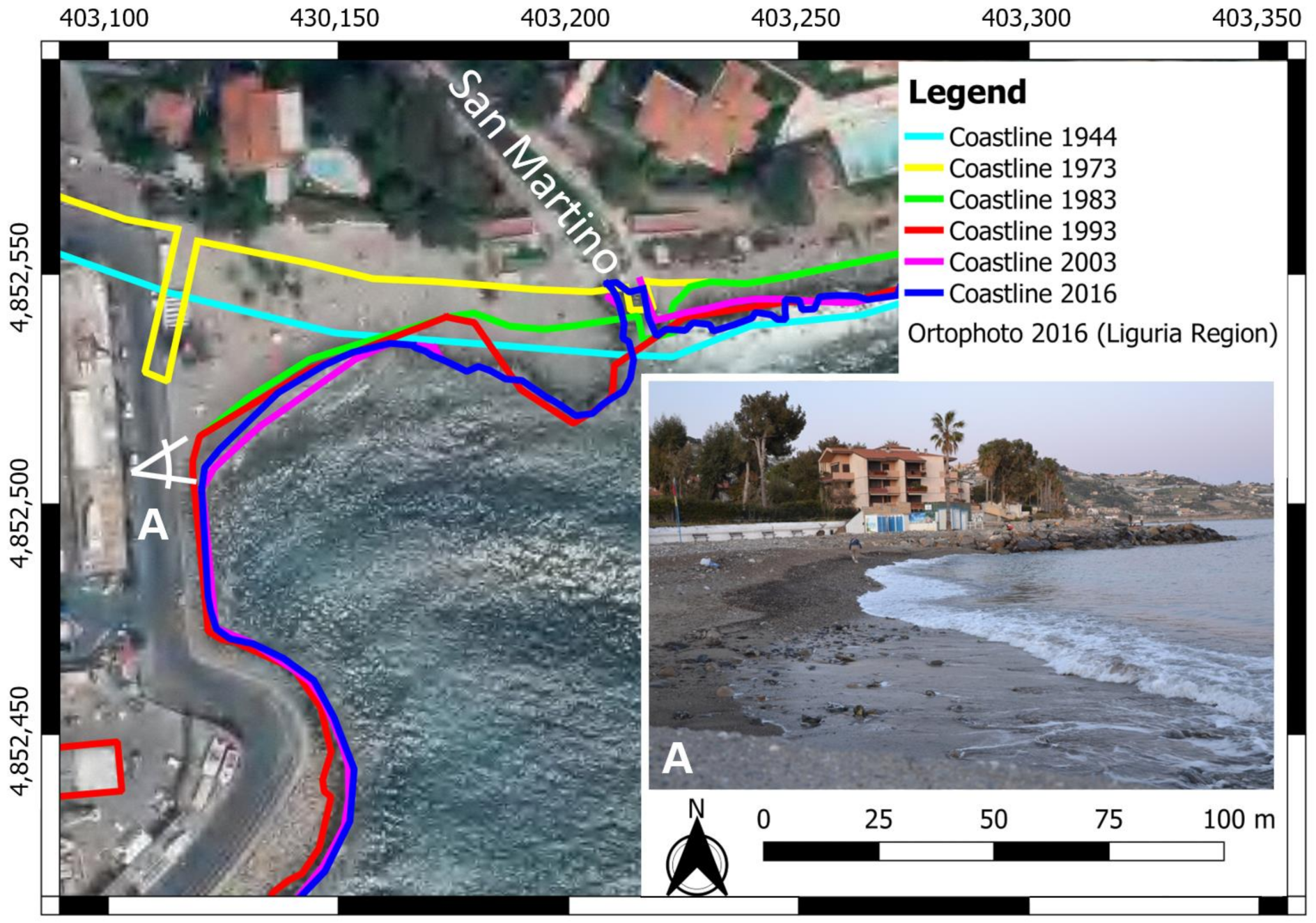
- The small beach about 90 m in extent, located between the mouth of the San Martino Stream and the root of the breakwater, assumed the characteristics of an anthropic pocket-beach [53,54,55]. In fact, it is between the maritime works and the jettied mouth of the stream, which reached its current layout between 2013 and 2016. Figure 3 shows the variations of the shoreline position over the years. Overall, the multi-temporal coastal line comparison shows a fairly stable equilibrium of the shoreline, with advancement of about 3 m (1983–2016). The alternating stages of advancement and retreat were presumably due to the restoration works at the river mouth and to small maintenance interventions of beach nourishment [56,57,58]. Since 1983 (Figure 3), the eastern side of the jetted mouth is constituted by the seawall.
3. The Event of 29 October 2018
4. Materials and Methods
4.1. Portosole
4.2. Resulting Products
5. Results
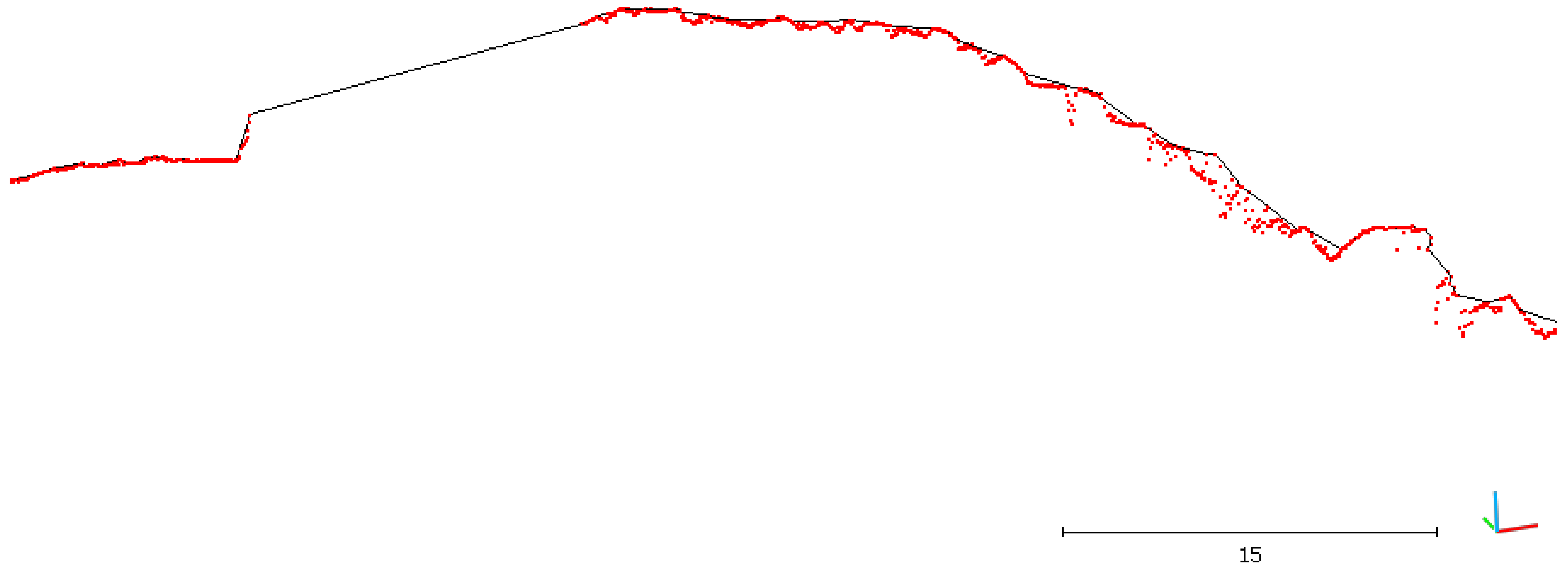
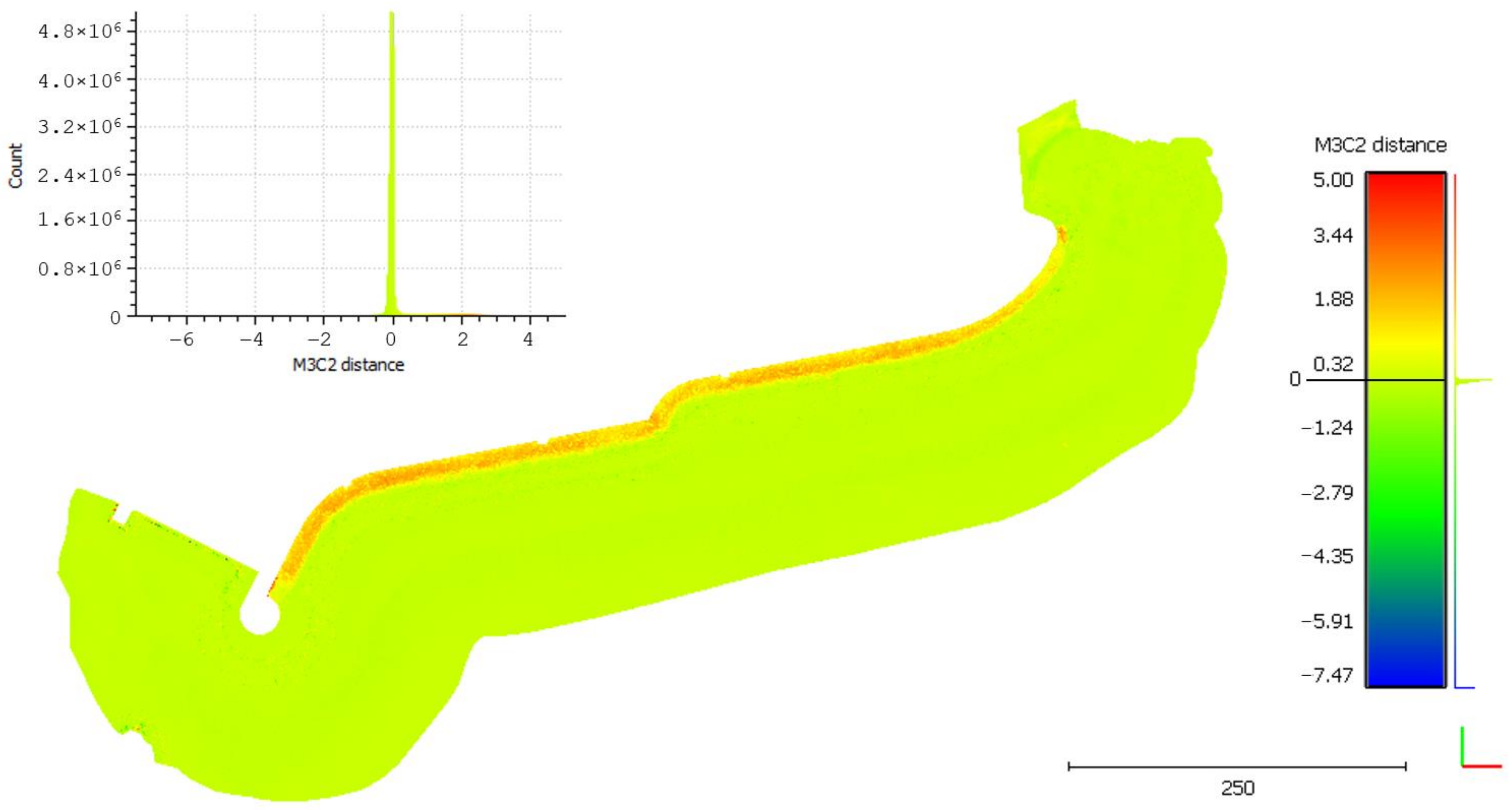
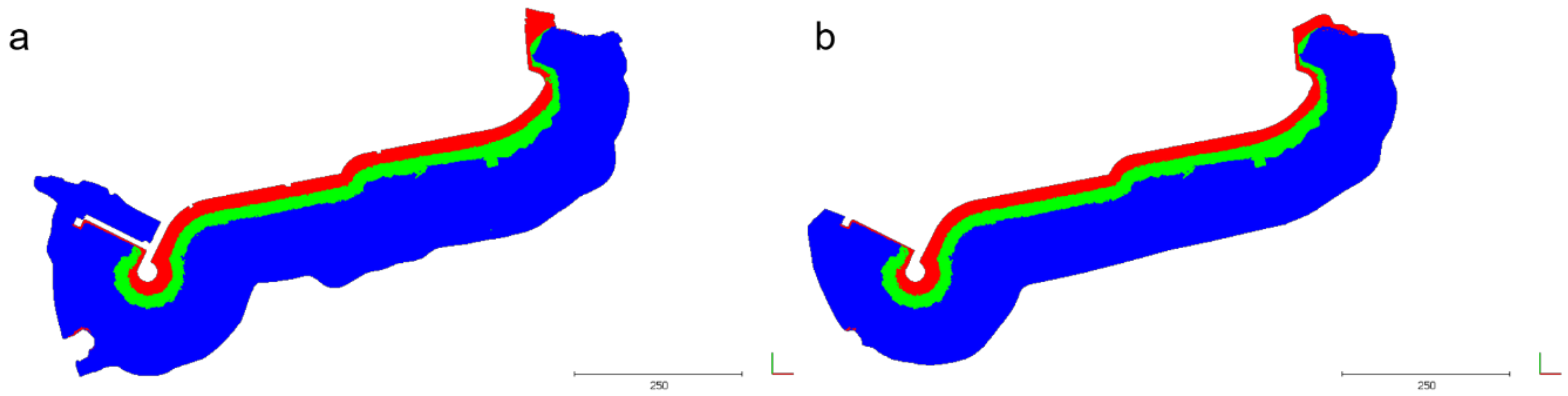
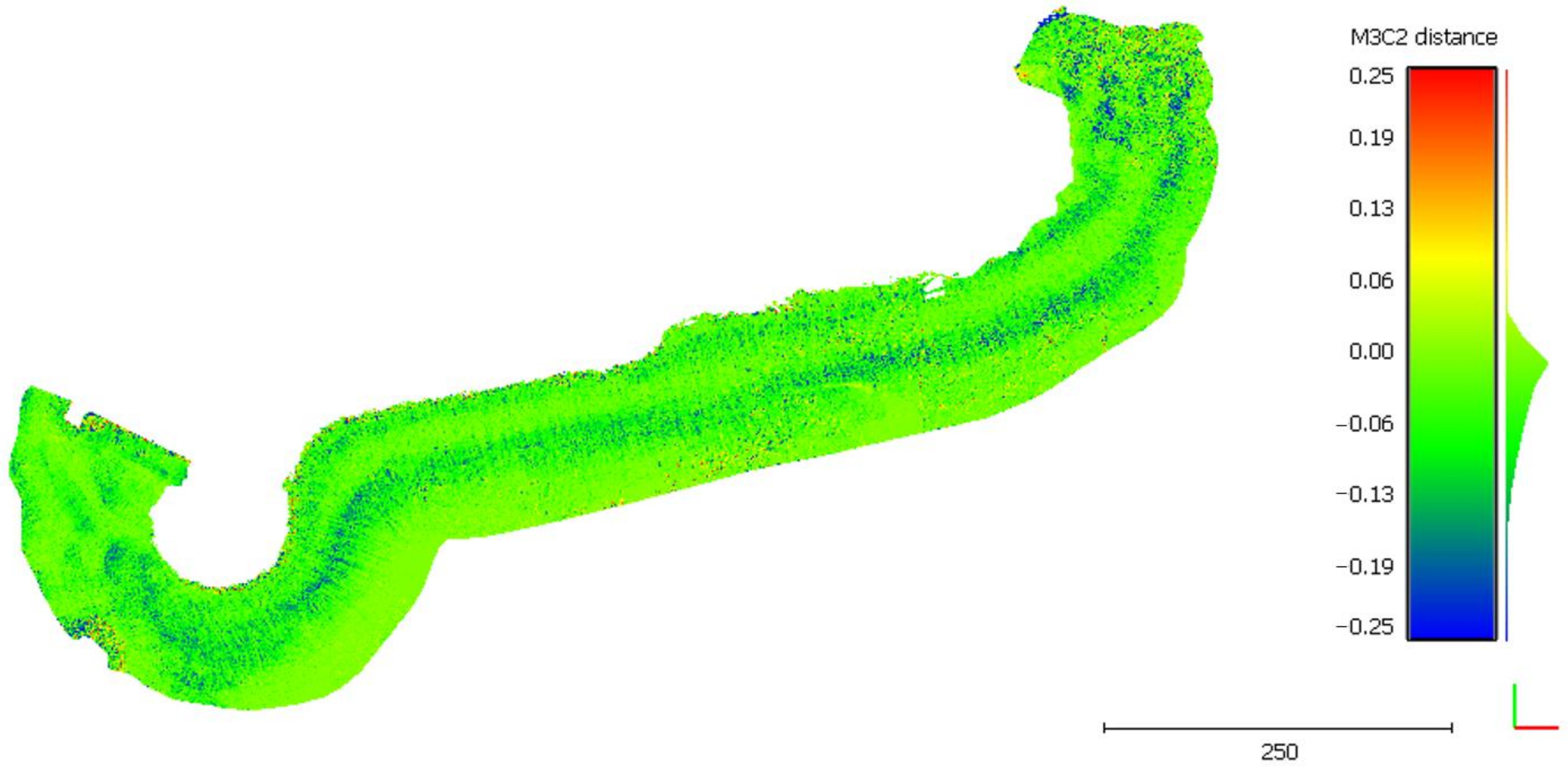
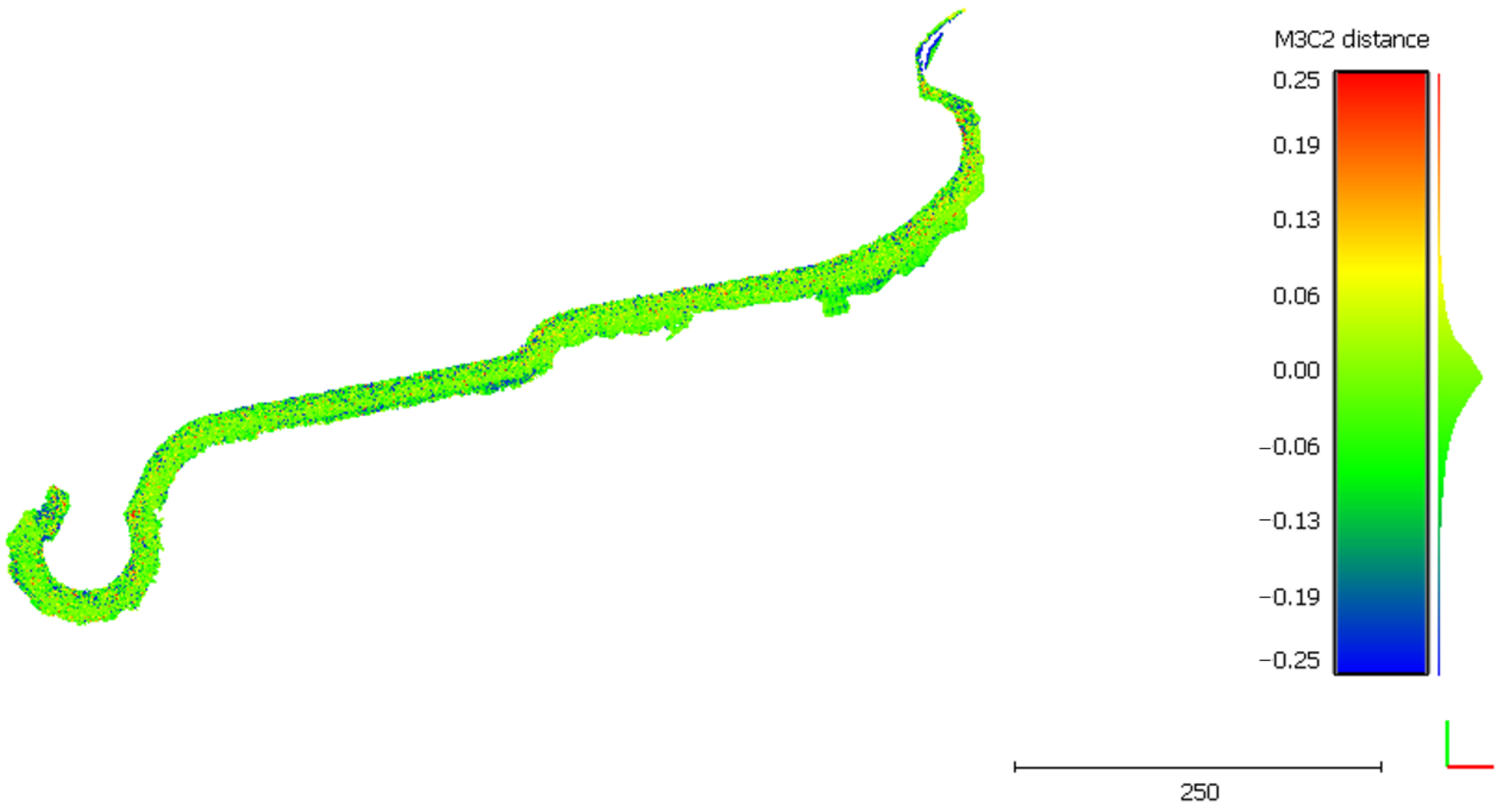
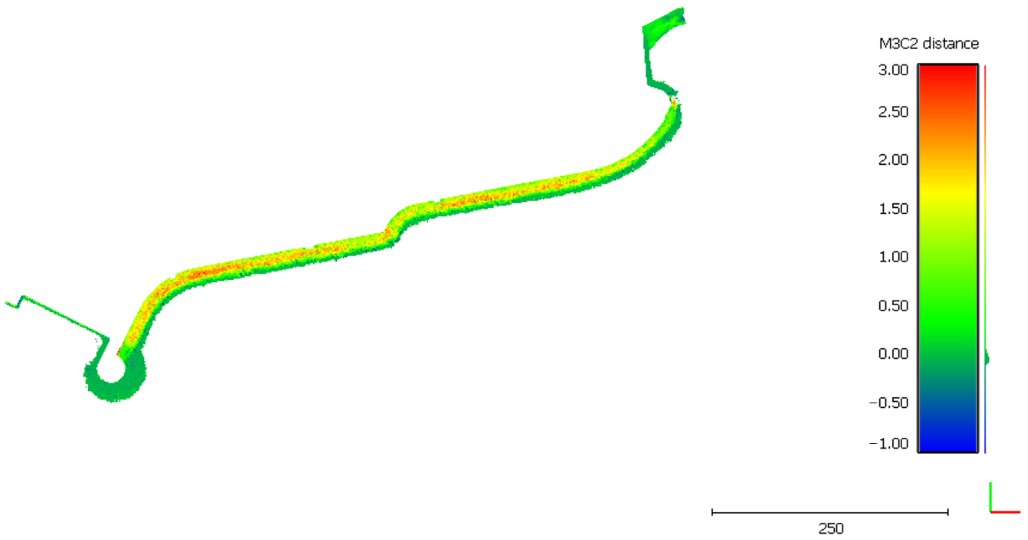
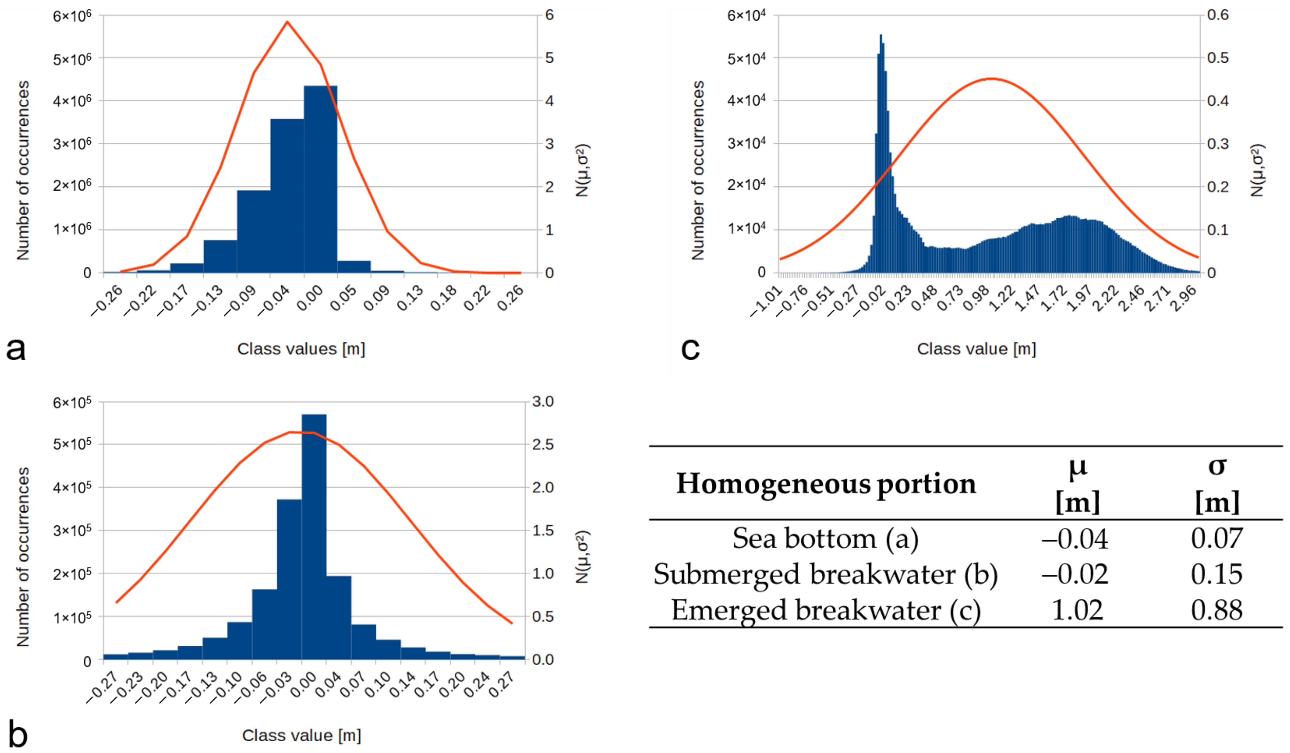
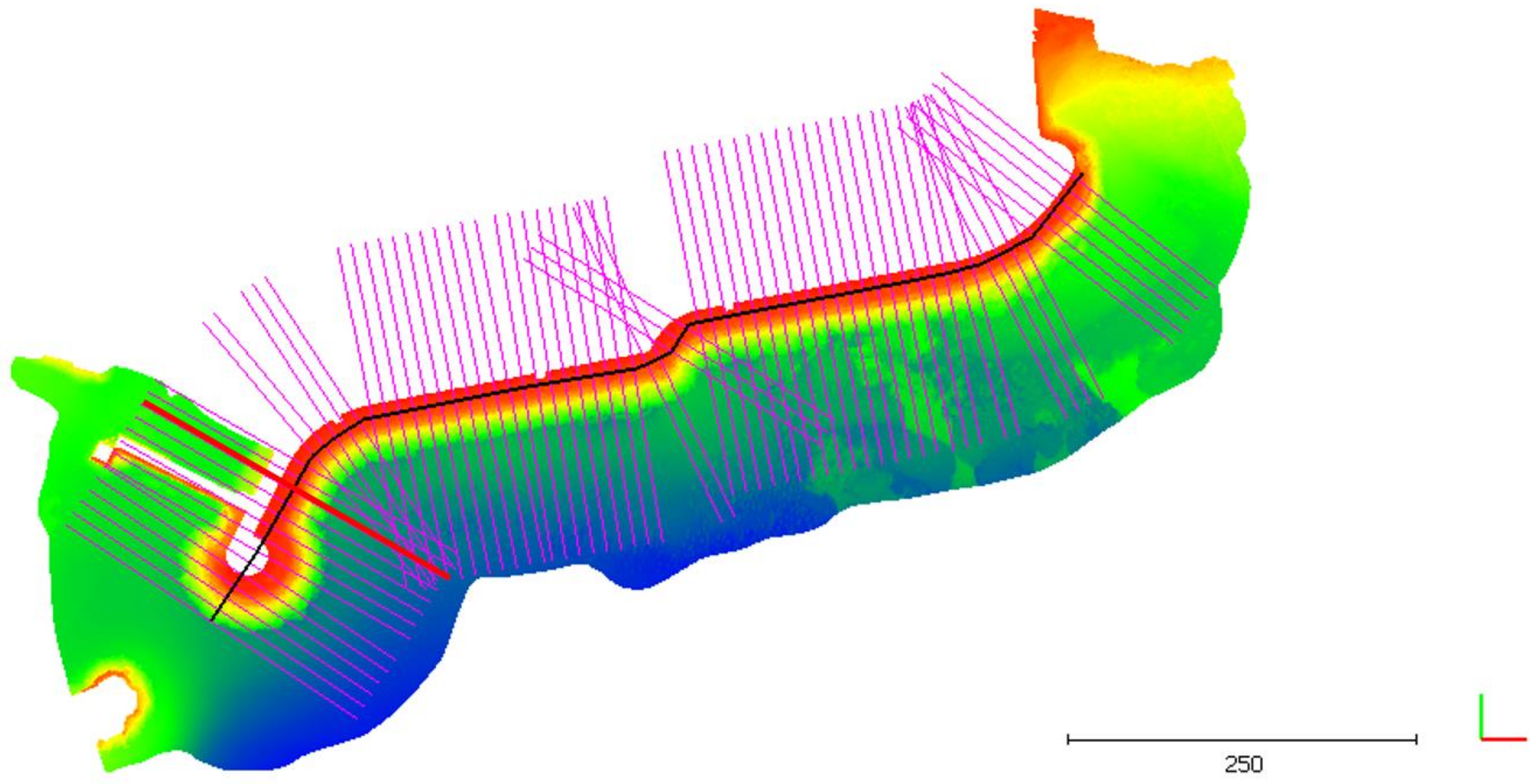
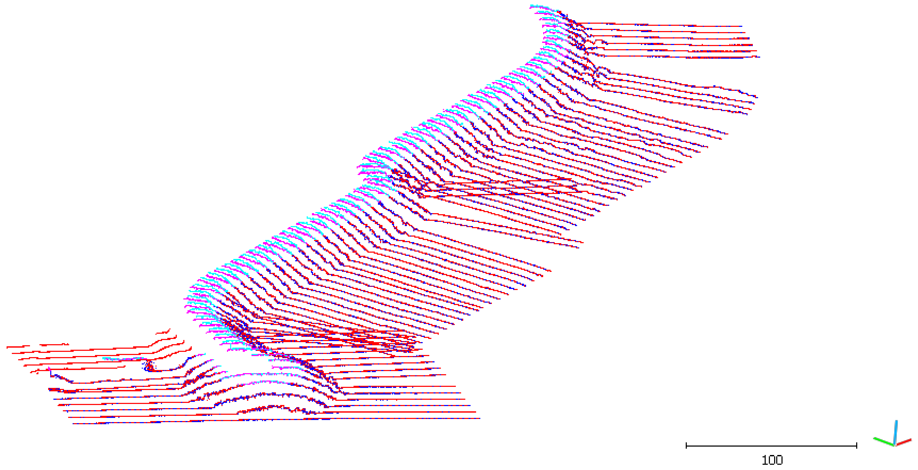
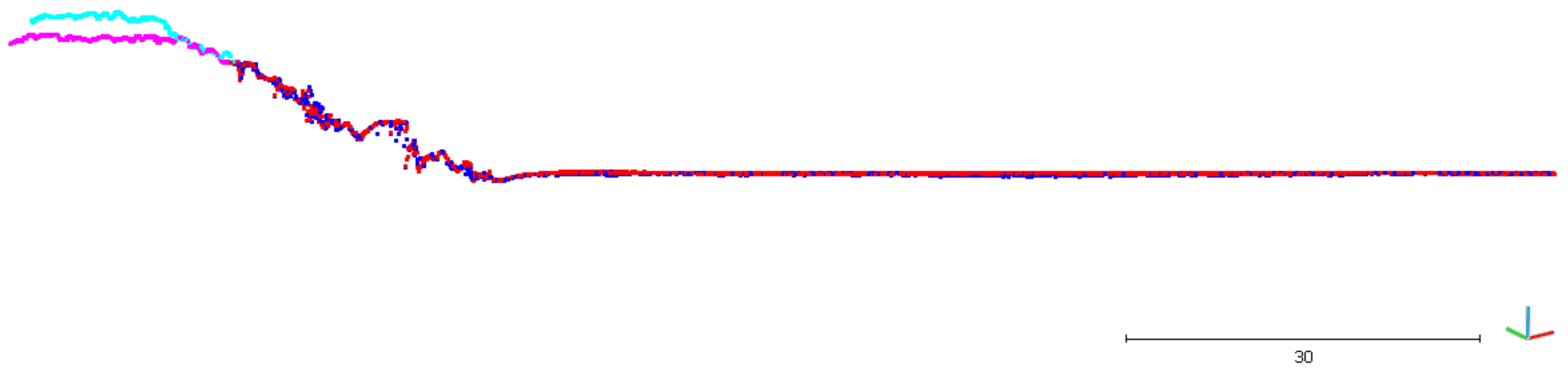
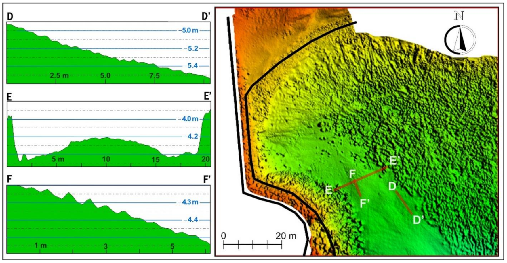
5.1. Results on DSMs Comparison
5.2. Results on Morphological and Sedimentary Dynamics of the Seabed
6. Discussion
7. Conclusions
Author Contributions
Funding
Institutional Review Board Statement
Informed Consent Statement
Data Availability Statement
Acknowledgments
Conflicts of Interest
References
- Mills, J.P.; Buckley, S.J.; Mitchell, H.L.; Clarke, P.J.; Edwards, S.J. A geomatics data integration technique for coastal change monitoring. Earth Surf. Process. Landf. J. Br. Geomorphol. Res. Group 2005, 30, 651–664. [Google Scholar] [CrossRef]
- Lague, D.; Brodu, N.; Leroux, J. Accurate 3D comparison of complex topography with terrestrial laser scanner: Application to the Rangitikei canyon (N-Z). ISPRS J. Photogramm. Remote Sens. 2013, 82, 10–26. [Google Scholar] [CrossRef] [Green Version]
- Mancini, F.; Dubbini, M.; Gattelli, M.; Stecchi, F.; Fabbri, S.; Gabbianelli, G. Using unmanned aerial vehicles (UAV) for high-resolution reconstruction of topography: The structure from motion approach on coastal environments. Remote Sens. 2013, 5, 6880–6898. [Google Scholar] [CrossRef] [Green Version]
- Monteys, X.; Harris, P.; Caloca, S.; Cahalane, C. Spatial prediction of coastal bathymetry based on multispectral satellite imagery and multibeam data. Remote Sens. 2015, 7, 13782–13806. [Google Scholar] [CrossRef] [Green Version]
- Troisi, S.; Del Pizzo, S.; Gaglione, S.; Miccio, S.; Testa, R.L. 3D models comparison of complex shell in underwater and dry environments. Int. Arch. Photogramm. Remote Sens. Spat. Inf. Sci. 2015, 40, 215–222. [Google Scholar] [CrossRef] [Green Version]
- Turner, I.L.; Harley, M.D.; Drummond, C.D. UAVs for coastal surveying. Coast. Eng. 2016, 114, 19–24. [Google Scholar] [CrossRef]
- Aguilar, F.J.; Fernandez, I.; Casanova, J.A.; Ramos, F.J.; Aguilar, M.A.; Blanco, J.L.; Moreno, J.C. 3D Coastal Monitoring from Very Sense UAV-Based Photogrammetric Point Clouds. In Advances on Mechanics, Design Engineering and Manufacturing; Springer: Cham, Switzerland, 2017; pp. 879–887. [Google Scholar]
- Capra, A.; Castagnetti, C.; Dubbini, M.; Gruen, A.; Guo, T.; Mancini, F.T.; Troyer, M. High Accuracy Underwater Photogrammetric Surveying. In Proceedings of the 3rd IMEKO International Conference on Metrology for Archeology and Cultural Heritage, Lecce, Italy, 23–25 October 2017; pp. 696–701. [Google Scholar]
- Chen, B.; Yang, Y.; Wen, H.; Ruan, H.; Zhou, Z.; Luo, K.; Zhong, F. High-resolution monitoring of beach topography and its change using unmanned aerial vehicle imagery. Ocean Coast. Manag. 2018, 160, 103–116. [Google Scholar] [CrossRef]
- Mattei, G.; Troisi, S.; Aucelli, P.P.C.; Pappone, G.; Peluso, F.; Stefanile, M. Multiscale Reconstruction of Natural and Archaeological Underwater Landscape by Optical and Acoustic Sensors. In Proceedings of the 2018 IEEE International Workshop on Metrology for the Sea, Learning to Measure Sea Health Parameters (MetroSea), Bari, Italy, 8–10 October 2018; pp. 46–49. [Google Scholar]
- Aucelli, P.P.C.; Cinque, A.; Mattei, G.; Pappone, G.; Rizzo, A. Studying relative sea level change and correlative adaptation of coastal structures on submerged Roman time ruins nearby Naples (southern Italy). Quat. Int. 2019, 501, 328–348. [Google Scholar] [CrossRef]
- Federici, B.; Corradi, N.; Ferrando, I.; Sguerso, D.; Lucarelli, A.; Guida, S.; Brandolini, P. Remote sensing techniques applied to geomorphological mapping of rocky coast: The case study of Gallinara Island (Western Liguria, Italy). Eur. J. Remote Sens. 2019, 52, 123–136. [Google Scholar] [CrossRef] [Green Version]
- Guida, S.; Corradi, N.; Federici, B.; Lucarelli, A.; Brandolini, P. Laser Scanner and Multibeam Integrated Survey for The Assessment of Rocky Sea Cliff Geomorphological Hazard. In Earth Observation Advancements in A Changing World; Chirici, G., Gianinetto, M., Eds.; AIT: Firenze, Italy, 2019; Volume 1, pp. 162–165. [Google Scholar]
- Scicchitano, G.; Pignatelli, C.; Spampinato, C.R.; Piscitelli, A.; Milella, M.; Monaco, C.; Mastronuzzi, G. Terrestrial Laser Scanner techniques in the assessment of tsunami impact on the Maddalena peninsula (south-eastern Sicily, Italy). Earth Planets Space 2012, 64, 889–903. [Google Scholar] [CrossRef] [Green Version]
- Piscitelli, A.; Milella, M.; Hippolyte, J.-C.; Shah-hosseini, M.; Morhange, C.; Mastronuzzi, G. Numerical approach to the study of coastal boulders: The case of Martigues, Marseille, France. Quat. Int. 2017, 439, 52–64. [Google Scholar] [CrossRef]
- Oprandi, A.; Mucerino, L.; De Leo, F.; Bianchi, C.N.; Morri, C.; Azzola, A.; Benelli, F.; Besio, G.; Ferrari, M.; Montefalcone, M. Effects of a severe storm on seagrass meadows. Sci. Total Environ. 2020, 748, 141373. [Google Scholar] [CrossRef]
- Biolchi, S.; Denamiel, C.; Devoto, S.; Korbar, T.; Macovaz, V.; Scicchitano, G.; Vilibic, I.; Furlani, S. Impact of the October 2018 storm Vaia on coastal boulders in the northern Adriatic Sea. Water 2019, 11, 2229. [Google Scholar] [CrossRef] [Green Version]
- Gaertner, M.A.; Jacob, D.; Gil, V.; Domínguez, M.; Padorno, E.; Sánchez, E.; Castro, M. Tropical cyclones over the Mediterranean Sea in climate change simulations. Geophys. Res. Lett. 2007, 34, 1–5. [Google Scholar] [CrossRef] [Green Version]
- Lionello, P.; Galati, M.B.; Elvini, E. Extreme storm surge and wind wave climate scenario simulations at the Venetian littoral. Phys. Chem. Earth 2012, 40, 86–92. [Google Scholar] [CrossRef]
- Gonzáles-Alemán, J.J.; Pascale, S.; Gutierrez-Fernandez, J.; Murakami, H.; Gaertner, M.A.; Vecchi, G.A. Potential Increase in Hazard from Mediterranean Hurricane Activity with Global Warming. Geophys. Res. Lett. 2019, 46, 1754–1764. [Google Scholar] [CrossRef]
- Faccini, F.; Brandolini, P.; Robbiano, A.; Perasso, L.; Sola, A. Instability, precipitation phenomena and land planning: The flood of 2002 in lower Lavagna valley (Eastern Liguria, Italy). Geogr. Fis. Din. Quat. 2005, 7, 145–153. [Google Scholar]
- Brandolini, P.; Faccini, F.; Robbiano, A.; Terranova, R. Geomorphological hazards and monitoring activity along the western rocky coast of the Portofino Promontory (Italy). Quat. Int. 2007, 171, 131–142. [Google Scholar] [CrossRef]
- Brandolini, P.; Canepa, G.; Faccini, F.; Robbiano, A.; Terranova, R. Geomorphological and geo-environmental features of the Graveglia Valley (Ligurian Apennines, Italy). Geogr. Fis. Din. Quat. 2007, 30, 99–116. [Google Scholar]
- Casella, E.; Rovere, A.; Pedroncini, A.; Mucerino, L.; Casella, M.; Cusati, L.A.; Vacchi, M.; Ferrari, M.; Firpo, M. Study of wave runup using numerical models and low-altitude aerial photogrammetry: A tool for coastal management. Estuar. Coast. Shelf Sci. 2014, 149, 160–167. [Google Scholar] [CrossRef]
- Brandolini, P.; Cevasco, A. Geo-Hydrological Risk Mitigation Measures and Land-Management in A Highly Vulnerable Small Coastal Catchment. In Engineering Geology for Society and Territory; Springer: Cham, Switzerland, 2015; Volume 5, pp. 759–762. [Google Scholar]
- Galve, J.; Cevasco, A.; Brandolini, P.; Piacentini, D.; Azañón, J.M.; Notti, D.; Soldati, M. Cost-based analysis of mitigation measures for shallow-landslide risk reduction strategies. Eng. Geol. 2016, 213, 142–157. [Google Scholar] [CrossRef]
- Carpi, L.; Mucerino, L.; Besio, G.; Corradi, N.; Ferrari, M. MAREGOT Project Experience: Integrated Approach to Understanding Coastal Dynamics Behaviour. In Proceedings of the 2019 IMEKO TC19 International Workshop on Metrology for the Sea: Learning to Measure Sea Health Parameters, MetroSea, Genoa, Italy, 3–5 October 2019; pp. 167–171. [Google Scholar]
- Ferrari, M.; Carpi, L.; Pepe, G.; Mucerino, L.; Schiaffino, C.F.; Brignone, M.; Cevasco, A. A geomorphological and hydrodynamic approach for beach safety and sea bathing risk estimation. Sci. Total Environ. 2019, 671, 1214–1226. [Google Scholar] [CrossRef]
- Mucerino, L.; Albarella, M.; Carpi, L.; Besio, G.; Benedetti, A.; Corradi, N.; Firpo, M.; Ferrari, M. Coastal exposure assessment on Bonassola bay. Ocean Coast. Manag. 2019, 167, 20–31. [Google Scholar] [CrossRef]
- Ascari, M.; Baccino, L.; Sanguineti, G. Ricerche Sulle Variazioni Delle Spiagge Italiane. Le Spiagge Della Riviera Ligure; C.N.R.: Roma, Italy, 1937; p. 328. [Google Scholar]
- Porta, M.; Buosi, C.; Trogu, D.; Ibba, A.; De Muro, S. An integrated sea-land approach for analyzing forms, processes, deposits and the evolution of the urban coastal belt of Cagliari. J. Maps 2020. [Google Scholar] [CrossRef] [Green Version]
- Mentaschi, L.; Besio, G.; Cassola, F.; Mazzino, A. Developing and validating a forecast/hindcast system for the Mediterranean Sea. J. Coast. Res. 2013, 65, 1551–1556. [Google Scholar] [CrossRef]
- Iengo, A.; del Giudice, T. Analysis of the 29 October 2018 Sea-Storm in The Ligurian Sea. In Proceedings of the 2019 IMEKO TC 19 International Workshop on Metrology for the Sea, Genoa, Italy, 3–5 October 2019; pp. 145–150. [Google Scholar]
- Pedemonte, L.; Corazza, M.; Forestieri, A. Internal Technical Event Report from CMI—ARPAL. Available online: https://www.arpal.gov.it/contenuti_statici//pubblicazioni/rapporti_eventi/2018/Report_speditivo_20181027-30_vers20181122.pdf (accessed on 6 November 2020).
- Lucarelli, A.; Brandolini, P.; Corradi, N.; De Laurentiis, L.; Federici, B.; Ferrando, I.; Lanzone, A.; Sguerso, D. Potentialities of Integrated 3D Surveys Applied to Maritime Infrastructures and to The Study of Morphological/Sedimentary Dynamics of The Seabed. In Proceedings of the IMEKO TC-19 International Workshop on Metrology for the Sea, Genoa, Italy, 3–5 October 2019; pp. 161–166. [Google Scholar]
- Giammarino, S.; Fanucci, F.; Orezzi, S.; Rosti, D.; Morelli, D.; Colbianchi, M.; Di Stefano, A.; Fravega, P.; Vannucci, G.; Piazza, M.; et al. Note Illustrative della Carta Geologica d’Italia alla scala 1:50.000. In Foglio 258–271 San Remo; ISPRA Servizio Geologico d’Italia, Regione Liguria: Genova, Italy, 2010; p. 134. Available online: https://www.isprambiente.gov.it/Media/carg/note_illustrative/258_SanRemo.pdf (accessed on 6 November 2020).
- Zingaro, M.; Refice, A.; Giachetta, E.; D’Addabbo, A.; Lovergine, F.; De Pasquale, V.; Pepe, G.; Brandolini, P.; Cevasco, A.; Capolongo, D. Sediment mobility and connectivity in a catchment: A new mapping approach. Sci. Total Environ. 2019, 672, 763–775. [Google Scholar] [CrossRef]
- Fierro, G.; Berriolo, G.; Ferrari, M. Le Spiagge Della Liguria Occidentale; Regione Liguria: Genova, Italy, 2010; p. 174. [Google Scholar]
- Corradi, N. La costa della Liguria. In La Costa d’Italia; Ginesu, S., Ed.; Carlo Delfino: Sassari, Italy, 2011; pp. 185–200. ISBN 978-88-7138-581-5. [Google Scholar]
- Brandolini, P.; Faccini, F.; Robbiano, A.; Terranova, R. Slope instability on rocky coast: A case study of Le Grazie landslides (eastern Liguria, northern Italy). Geol. Soc. Lond. Spec. Publ. 2009, 322, 143–154. [Google Scholar] [CrossRef]
- Scarpati, A.; Pepe, G.; Mucerino, L.; Brandolini, P.; Firpo, M. Rocky cliff landslide hazard: The capo Noli promontory case study (western Liguria, NW Mediterranean Sea). Rend. Online Soc. Geol. Ital. 2013, 28, 137–141. [Google Scholar]
- Fierro, G.; Berriolo, G.; Ferrari, M. Le Spiagge Della Liguria Centro-Orientale; Regione Liguria: Genova, Italy, 2015; p. 96. [Google Scholar]
- Brandolini, P. The Outstanding Terraced Landscape of The Cinque Terre Coastal Slopes (Eastern Liguria). In Landscapes and Landforms of Italy; Springer: Cham, Switzerland, 2017; pp. 235–244. [Google Scholar]
- Pepe, G.; Mandarino, A.; Raso, E.; Scarpellini, P.; Brandolini, P.; Cevasco, A. Investigation on farmland abandonment of terraced slopes using multitemporal data sources comparison and its implication on hydro-geomorphological processes. Water 2019, 11, 1552. [Google Scholar] [CrossRef] [Green Version]
- Brandolini, P.; Faccini, F.; Paliaga, G.; Piana, P. Man-made landforms survey and mapping of an urban historical center in a coastal Mediterranean environment. Geogr. Fis. Din. Quat. 2018, 41, 23–34. [Google Scholar]
- Ascione, A.; Aucelli, P.P.; Cinque, A.; Di Paola, G.; Mattei, G.; Ruello, M.; Russo Ermolli, E.; Santangelo, N.; Valente, E. Geomorphology of Naples and the Campi Flegrei: Human and natural landscapes in a restless land. J. Maps 2020. [Google Scholar] [CrossRef]
- Brandolini, P.; Mandarino, A.; Paliaga, G.; Faccini, F. Anthropogenic landforms in an urbanized alluvial-coastal plain (Rapallo city, Italy). J. Maps 2020. [Google Scholar] [CrossRef]
- Cappadonia, C.; Di Maggio, C.; Agate, M.; Agnesi, V. Geomorphology of the urban area of Palermo (Italy). J. Maps 2020, 16, 1739154. [Google Scholar] [CrossRef] [Green Version]
- Faccini, F.; Giardino, M.; Paliaga, G.; Perotti, L.; Brandolini, P.; Giardino, M.; Paliaga, G.; Perotti, L.; Brandolini, P. Urban geomorphology of Genoa old city (Italy). J. Maps 2020. [Google Scholar] [CrossRef]
- Roccati, A.; Mandarino, A.; Perasso, L.; Robbiano, A.; Luino, F.; Faccini, F. Large-scale geomorphology of the Entella River floodplain (Italy) for coastal urban areas management. J. Maps 2020. [Google Scholar] [CrossRef] [Green Version]
- Mucerino, L.; Carpi, L.; Schiaffino, C.F.; Pranzini, E.; Sessa, E.; Ferrari, M. Rip current hazard assessment on a sandy beach in Liguria, NW Mediterranean. Nat. Hazards 2021, 105, 137–156. [Google Scholar] [CrossRef]
- Vinzoni, A. Pianta della città di Sanremo (1753). In Raccolta dei Tipi, disegni e mappe, Mappe e tipi della Repubblica di Genova, involto RR, n. 2.; Archivio di Stato: Genova, Italy, 1753. [Google Scholar]
- Short, A.D.; Masselink, G. Embayed and Structurally Controlled Beaches. In Handbook of Beach and Shoreface Morphodynamics; John Wiley & Son: Chichester, UK, 1999; pp. 230–249. [Google Scholar]
- Simeoni, U.; Corbau, C.; Pranzini, E.; Ginesu, S. Le Pocket Beach. Dinamica E Gestione Delle Piccole Spiagge; FrancoAngeli: Milano, Italy, 2012; p. 177. [Google Scholar]
- Mastronuzzi, G.; Aringoli, D.; Aucelli, P.P.; Baldassarre, M.A.; Bellotti, P.; Bini, M.; Biolchi, S.; Bontempi, S.; Brandolini, P.; Chelli, A.; et al. The geomorphological map of the Italian coast: From a descriptive to a morphodynamic approach. Geogr. Fis. Din. Quat. 2017, 40, 1–36. [Google Scholar]
- Berriolo, G.; Sirito, G. Spiagge e Porti Turistici; Ulrico Hoepli: Milano, Italy, 1972; p. 430. [Google Scholar]
- Lamanna, S. Il Sistema Informativo Geografico Della Costa e Il Censimento Delle Opere Costiere Della Regione Liguria. In Lo Studio e la Rappresentazione Della Costa Ligure nel Progetto Europeo BEACHMED-E., A Cura Di Corinna Artom; Regione Liguria: Genova, Italy, 2008; pp. 113–119. [Google Scholar]
- SICoast-Regione Liguria. Available online: https://geoportal.regione.liguria.it/catalogo/mappe.html (accessed on 31 August 2020).
- Agisoft Metashape©. Available online: https://www.agisoft.com/ (accessed on 25 March 2020).
- Gagliolo, S.; Fagandini, R.; Passoni, D.; Federici, B.; Ferrando, I.; Pagliari, D.; Pinto, L.; Sguerso, D. Parameter optimization for creating reliable photogrammetric models in emergency scenarios. Appl. Geomat. 2018, 10, 501–514. [Google Scholar] [CrossRef]
- Passoni, D.; Federici, B.; Ferrando, I.; Gagliolo, S.; Sguerso, D. The estimation of precision in the planning of UAS photogrammetric surveys. Int. Arch. Photogramm. Remote Sens. Spat. Inf. Sci. 2018, 42, 837–843. [Google Scholar] [CrossRef] [Green Version]
- Fagandini, R.; Federici, B.; Ferrando, I.; Gagliolo, S.; Pagliari, D.; Passoni, D.; Pinto, L.; Rossi, L.; Sguerso, D. Evaluation Of The Laser Response Of Leica Nova Multistation MS60 For 3D Modelling And Structural Monitoring, Computational Science and Its Applications—ICCSA 2017. In Lecture Notes in Computer Science; Gervasi, O., Ed.; Springer: Cham, Switzerland, 2017; pp. 93–104. [Google Scholar]
- Teledyne Reson PDS2000. Available online: https://www.teledyne-pds.com (accessed on 25 March 2020).
- CloudCompare (version 2.10) [GPL Software]. Available online: http://www.cloudcompare.org/ (accessed on 25 March 2020).
- Vacchi, M.; Montefalcone, M.; Bianchi, C.N.; Morri, C.; Ferrari, M. The influence of coastal dynamics on the upper limit of the Posidonia oceanica meadow. Mar. Ecol. 2010, 31, 546–554. [Google Scholar] [CrossRef]
- Ferrari, M.; Montefalcone, M.; Schiaffino, C.F.; Bianchi, C.; Corradi, N.; Morri, C. Geomorphological Constraint and Boundary Effect on Posidonia Oceanica Meadows. In Rendiconti on Line Della Società Geologica Italiana; Società Geologica Italiana: Roma, Italy, 2013; Volume 28, pp. 62–65. [Google Scholar]
- Montefalcone, M.; Albertelli, G.; Nike Bianchi, C.; Mariani, M.; Morri, C. A new synthetic index and a protocol for monitoring the status of Posidonia oceanica meadows: A case study at Sanremo (Ligurian Sea, NW Mediterranean). Aquat. Conserv. Mar. Freshw. Ecosyst. 2006, 16, 29–42. [Google Scholar] [CrossRef]
- Montefalcone, M. Ecosystem health assessment using the Mediterranean seagrass Posidonia oceanica: A review. Ecol. Indic. 2009, 9, 595–604. [Google Scholar] [CrossRef]
- Diviacco, G.; Coppo, S. Atlante Degli Habitat Marini Della Liguria: Descrizione Cartografia Delle Praterie di Posidonia Oceanica e dei Principali Popolamenti Marini Costieri; Grafiche Amadeo: Imperia, Italy, 2006; p. 205. [Google Scholar]
- De Pippo, T.; Donadio, C.; Pennetta, M.; Petrosino, C.; Terlizzi, F.; Valente, A. Coastal hazard assessment and mapping in Northern Campania, Italy. Geomorphology 2008, 97, 451–466. [Google Scholar] [CrossRef]
- Aminti, P.L.; Pranzini, E. Indagine sperimentale per la ristrutturazione delle difese di Marina di Pisa. Studi Costieri 2000, 3, 57–70. [Google Scholar]
- Pranzini, E. Shore protection in Italy: From hard to soft engineering and back. Ocean Coast. Manag. 2018, 156, 43–57. [Google Scholar] [CrossRef]
- Tanner, W.F. Ripple mark indices and their uses. Sedimentology 1967, 9, 89–104. [Google Scholar] [CrossRef]
- US Army Corps of Engineers. Shore Protection Manual; Department of the Army, US Army Corps of Engineers: Washington DC, USA, 1984; Volume 2, p. 652.
- Gerhard, E. Sedimentary Basins Evolution, Facies and Sediment Budget; Springer: Berlin/Heidelberg, Germany, 2000. [Google Scholar]
- Bruun, P. The development of downdrift erosion. J. Coast. Res. 1995, 11, 1242–1257. [Google Scholar]
- Cipriani, L.E.; Ferri, S.; Iannotta, P.; Paolieri, F.; Pranzini, E. Morfologia e dinamica dei sedimenti del litorale della Toscana settentrionale. Studi Costieri 2001, 4, 119–156. [Google Scholar]
- Aminti, P.; Cipriani, L.E.; Pranzini, E. Back to the Beach: Converting Seawalls into Gravel Beaches. In Soft Shore Protection; Springer: Dordrecht, The Netherlands, 2003; pp. 261–274. [Google Scholar]
- Aucelli, P.C.; Aminti, P.L.; Amore, C.; Artom, C.; Bellotti, P.; Bozzano, A.; Caputo, C.; Castelliti, G.; Cipriani, L.E.; Cocco, E.; et al. Lo stato dei litorali italiani. Studi Costieri 2006, 10, 174. [Google Scholar]
- Migeon, S.; Cattaneo, A.; Hassoun, V.; Larroque, C.; Corradi, N.; Fanucci, F.; Dano, A.; Mercier de Lepinay, B.; Sage, F.; Gorini, C. Morphology, distribution and origin of recent submarine landslides of the Ligurian Margin (North-western Mediterranean): Some insights into geohazard assessment. Mar. Geophys. Res. 2011, 32, 225–243. [Google Scholar] [CrossRef] [Green Version]
- Brandolini, P.; Cappadonia, C.; Luberti, G.M.; Donadio, C.; Stamatopoulos, L.; Di Maggio, C.; Faccini, F.; Corrado, S.; Vergari, F.; Palliaga, G.; et al. Geomorphology of the Anthropocene in Mediterranean urban areas. Prog. Phys. Geogr. Earth Environ. 2020, 44, 461–494. [Google Scholar] [CrossRef]


| Homogeneous Portion | Deposited Volume (m3) | Eroded Volume (m3) | Surface (m2) | q (–) | Δh (m) |
|---|---|---|---|---|---|
| Sea bottom | 950 | −5964 | 113,500 | 0.16 | −0.04 |
| Submerged breakwater | 1094 | −1483 | 18,068 | 0.74 | −0.02 |
| Emerged breakwater | 15,022 | −221 | 13,688 | 67.9 | 1.08 |
Publisher’s Note: MDPI stays neutral with regard to jurisdictional claims in published maps and institutional affiliations. |
© 2021 by the authors. Licensee MDPI, Basel, Switzerland. This article is an open access article distributed under the terms and conditions of the Creative Commons Attribution (CC BY) license (https://creativecommons.org/licenses/by/4.0/).
Share and Cite
Ferrando, I.; Brandolini, P.; Federici, B.; Lucarelli, A.; Sguerso, D.; Morelli, D.; Corradi, N. Coastal Modification in Relation to Sea Storm Effects: Application of 3D Remote Sensing Survey in Sanremo Marina (Liguria, NW Italy). Water 2021, 13, 1040. https://doi.org/10.3390/w13081040
Ferrando I, Brandolini P, Federici B, Lucarelli A, Sguerso D, Morelli D, Corradi N. Coastal Modification in Relation to Sea Storm Effects: Application of 3D Remote Sensing Survey in Sanremo Marina (Liguria, NW Italy). Water. 2021; 13(8):1040. https://doi.org/10.3390/w13081040
Chicago/Turabian StyleFerrando, Ilaria, Pierluigi Brandolini, Bianca Federici, Antonio Lucarelli, Domenico Sguerso, Danilo Morelli, and Nicola Corradi. 2021. "Coastal Modification in Relation to Sea Storm Effects: Application of 3D Remote Sensing Survey in Sanremo Marina (Liguria, NW Italy)" Water 13, no. 8: 1040. https://doi.org/10.3390/w13081040
APA StyleFerrando, I., Brandolini, P., Federici, B., Lucarelli, A., Sguerso, D., Morelli, D., & Corradi, N. (2021). Coastal Modification in Relation to Sea Storm Effects: Application of 3D Remote Sensing Survey in Sanremo Marina (Liguria, NW Italy). Water, 13(8), 1040. https://doi.org/10.3390/w13081040