Abstract
An application is presented of a new methodology for the real-time operations of river-reservoir systems. The methodology is based upon an optimization/simulation modeling approach that interfaces optimization with a one and/or two-dimensional unsteady flow simulation model (U.S. Army Corps of Engineers HEC-RAS). The approach also includes a model for short-term rainfall forecasting, and the U.S. Army Corps of Engineers HEC-HMS model for rainfall-runoff modeling. Both short-term forecasted rainfall in addition to gaged streamflow data and/or NEXRAD (Next-Generation Radar) can be implemented in the modeling approach. The optimization solution methodology is based upon a genetic algorithm implemented through MATLAB. The application is based upon the May 2010 flood event on the Cumberland River system in the USA, during which releases from Old Hickory dam caused major flooding in the downstream area of Nashville, TN, USA, and allowed the dam to be placed in an emergency operational situation. One of the major features of the modeling effort and the application presented was to investigate the use of different unsteady flow modeling approaches available in the HEC-RAS, including one-dimensional (1D), two-dimensional (2D), and the combined (1D/2D) approach. One of the major results of the application was to investigate the use the different unsteady flow approaches in the modeling approach. The 2D unsteady flow modeling, based upon the diffusion wave approach, was found to be superior for the application to the Cumberland River system. The model application successfully determined real-time operations that would have maintained the flood water surface elevations at the downstream control point in Nashville below the 100-year return period river water surface and maintaining the gate openings at the Old Hickory Dam from reaching an emergency operational situation, which could have caused major losses at the dam.
1. Introduction
Real-time flood operation of river-reservoir systems is a very severe problem all around the world. Flood management includes planned management and real-time management. The modeling approach developed herein focuses on the real-time management of river-reservoir systems. Real-time flood management requires real-time inflow data to determine releases from the control facilities. Sometimes, inflow data may not be available during the event time, so forecasting the required data for the short-term, depending on the availability, is required. The modeling approach focuses on the flooding caused by large rainfall events that require immediate responses in real-time. Flood forecasting studies endeavor to produce as accurate as possible future estimates of discharges from a reservoir-river system based on the present state, forecasted rainfall, and the past behavior of the river-reservoir system. The use of real-time flood warning systems and the real-time operation of river-reservoir systems require the real-time flood forecasts that can only be performed by the type of optimization/simulation models discussed in this paper.
The basic purpose of the optimization-simulation model for the real-time flood control operation of a river-reservoir system is to maintain the discharges and/or water surface elevations throughout the system below specified or target values at specified locations during an extreme storm event. Previous models based upon simplified hydrologic routing and simplified optimization models have proven to be non-effective. The overall model is formulated as a discrete optimal control problem that interfaces both an optimization model (genetic algorithm) and simulation models for the hydrologic and hydraulic modeling, and a short-term rainfall forecasting model. The model described herein uses real-time rainfall data and real-time stream flow data. The optimization/simulation model applied herein incorporates not only the unsteady flow routing based upon both one- and/or two-dimensional unsteady flow routing using the HEC-RAS, but also interfaces the HEC-HMS rainfall-runoff model, a short-term rainfall forecasting model, and a reservoir operation model defining flow through the gate operations.
Several models for reservoir operation that include flood control as one of the purposes, and that are based upon optimization, have been developed over the years, as reviewed in detail by Che and Mays [1]. However, there have been only a very few optimization approaches interfaced with unsteady flow simulation models that consider the real-time flood-control operation (gate control operations at dams) of river-reservoir systems. There are even fewer approaches that interface simulation models: (a) for rainfall-runoff analysis using both actual rainfall and predicted short term future rainfall, and (b) for unsteady flow propagation of floods through river-reservoir systems. Models that do have this ability include those developed by Unver, et al. [2], Unver and Mays [3], Ahmed and Mays [4], and Che and Mays [1,5]. These approaches have been reviewed by Che and Mays [1], and are the basis for the newer and expanded model reported by Albo-Salih and Mays [6].
Recent efforts at developing methods for flood control operations based upon optimization include Cuevas-Velasque et al. [7], Zha et al. [8], and Zhou et al. [9]. Recent efforts at developing methods based upon optimization and a one-dimensional model for the hydraulics include Nguyen [10], and Xu, et al. [11]. New risk-based models include those by Chen et al. [12], Sun et al. [13], Uysal et al. [14], Chen et al. [15], Chen et al. [16], and Lu, et al. [17]. Flood control based on hydraulics operations and uncertainty impacts have also been studied by Witcher-Dysarz et al. [18] and Dysarz [19]. Applications of two-dimensional hydraulic modeling for flood scenarios have been explored by Urzică et al. [20]. However, none of the above recent efforts have the capabilities of modeling of real-time flood control operations of reservoirs reported herein, and by Also-Salih and Mays [6].
The modeling approach developed and tested in Albo-Salih and Mays [6], which is the basis for the application herein, is based upon an optimal control approach which interfaces simulation models for rainfall-runoff analysis (HEC-HMS), an unsteady flow simulation model (HEC-RAS) for simulating one-dimensional (1D), two-dimensional (2D), or combined 1D and 2D unsteady flows through a river-reservoir system, a model for reservoir operation defining gate operations, and a short-term rainfall forecasting model. This new modeling approach has been designed for the real-time operations of reservoir gate operations in river-reservoir systems to minimize flooding conditions. Other models have been developed recently for real-time flood control, but lack the capabilities of the model discussed and applied herein, especially an optimization model and the capability of the model to handle both the combined 1D and 2D approaches, or just the 2D approach.
2. Cumberland River Basin
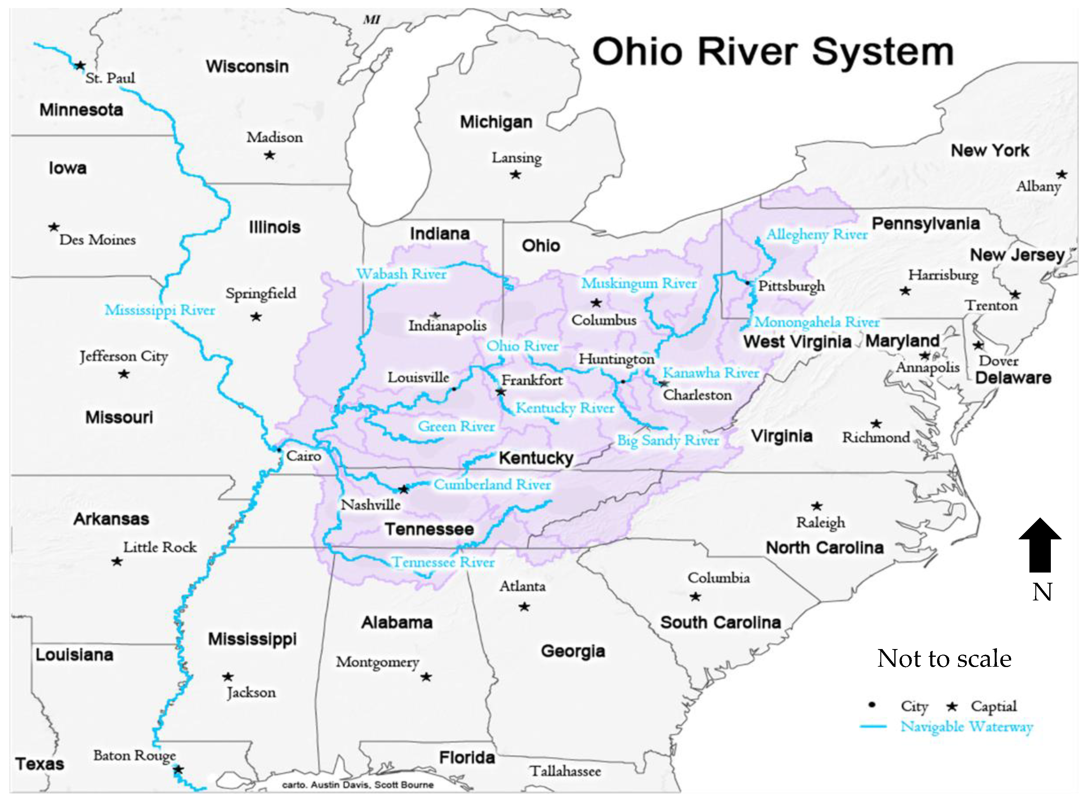
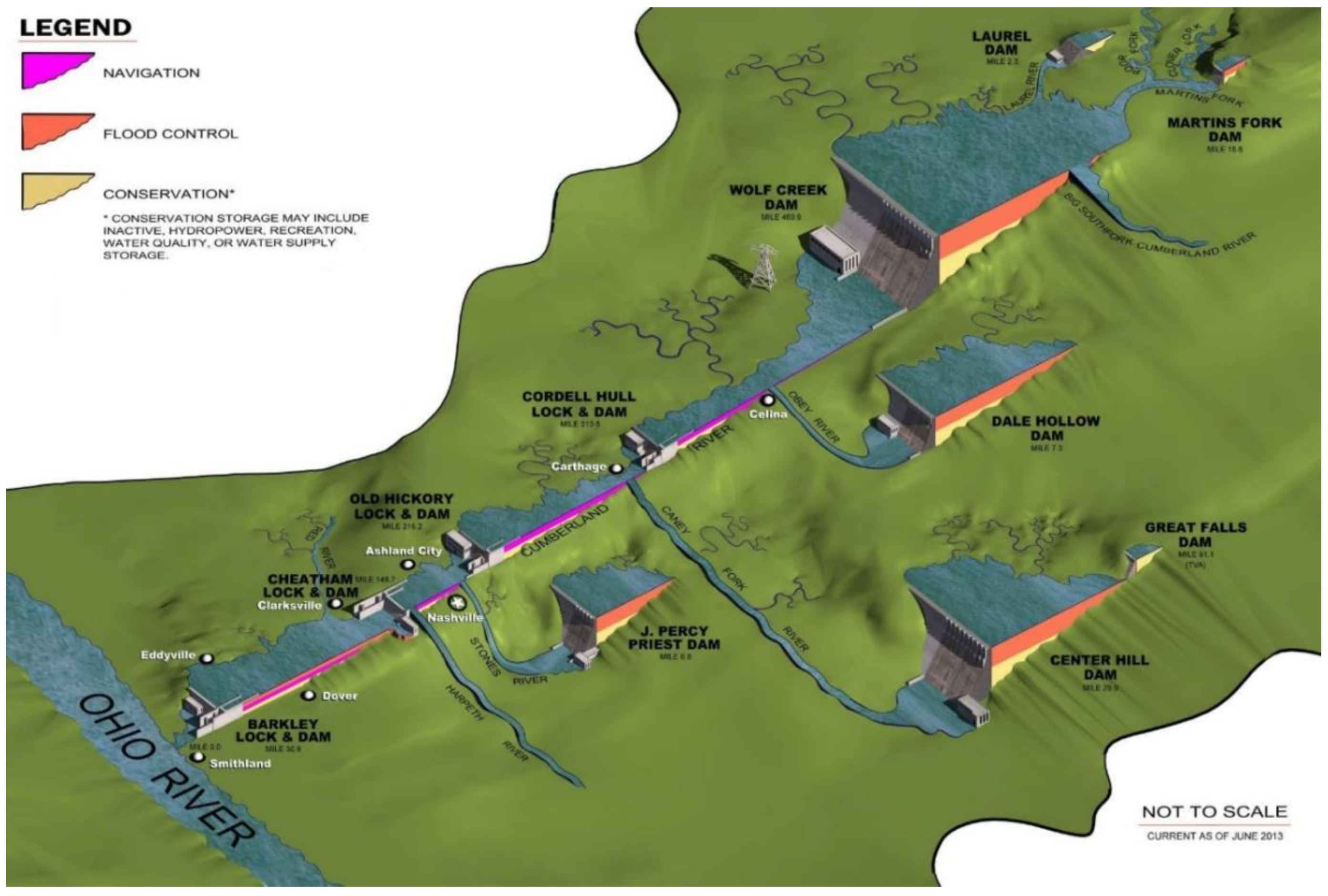
The Ohio River System is illustrated in Figure 1, which also shows the location of the Cumberland River and Nashville, Tennessee. The Cumberland River Basin, shown in Figure 2, is located entirely within the states of Kentucky and Tennessee, and has a total area of 17,914 mi2 miles, of which 10,695 square miles (60%) are in the state of Tennessee. The topography of the Cumberland River Basin changes from rugged mountains in the eastern upstream portion of the basin, to rolling low plateaus in the western, or downstream part of the basin [21,22].
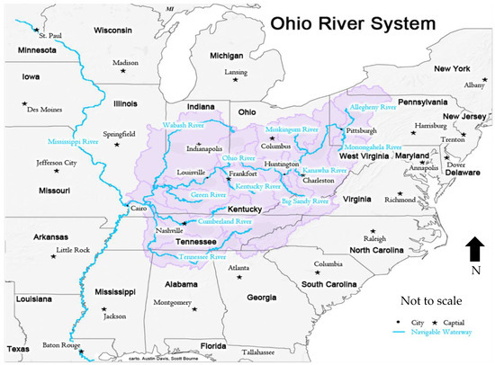
Figure 1.
Ohio River System showing the location of the Cumberland River and Nashville, TN, USA [23].
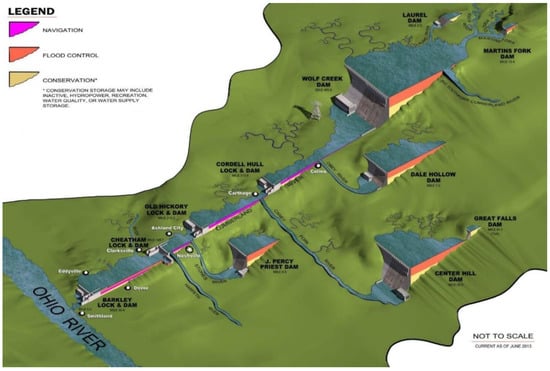
Figure 2.
Location of dam projects and purposes in the Cumberland River Basin [22].
Five projects on the Cumberland River mainstream are maintained and operated by the U.S. Army Corps of Engineers Nashville District, plus five other projects on the tributaries. The mainstream projects are the Cordell Hull, Barkley, Cheatham, Old Hickory, and Wolf Creek. The U.S. Congress has authorized Barkley, Cheatham, Old Hickory, and Cordell Hill for hydropower generation and commercial navigation. The five Corps of Engineers tributary projects, Dale Hollow, Center Hill, Martin’s Fork, Laurel, and J. Percy Priest, are congressionally authorized for flood risk management [21,22].
3. Flood Event of May 2010
Weather disturbances in the mid-level atmosphere contributed to trigger storms producing heavy rainfall over the mid-Mississippi and Lower Ohio Valley regions [24]. This rare convergence of conditions was obviously favorable for a large prolonged and powerful rainfall event over the central Continental U.S., and caused the May 2010 historic precipitation across Tennessee and Kentucky. Composite high-resolution precipitation images for 25–30 April 2010 indicated the extreme severity of rainfall several days in advance of the flooding [22]. On 30 April, a very intense storm system moved into the central parts of the United States, and, unfortunately, these precipitation images (warnings) for 25–30 April were ignored by the U.S. Army Corps of Engineers (USACE). Had the USACE not ignored these warnings, they could have started drawdowns at the Old Hickory Reservoir, which is immediately upstream of Nashville in particular, and at other upstream reservoirs. Appendix A briefly describes flooding at Old Hickory and downstream to Nashville.
3.1. Rainfall
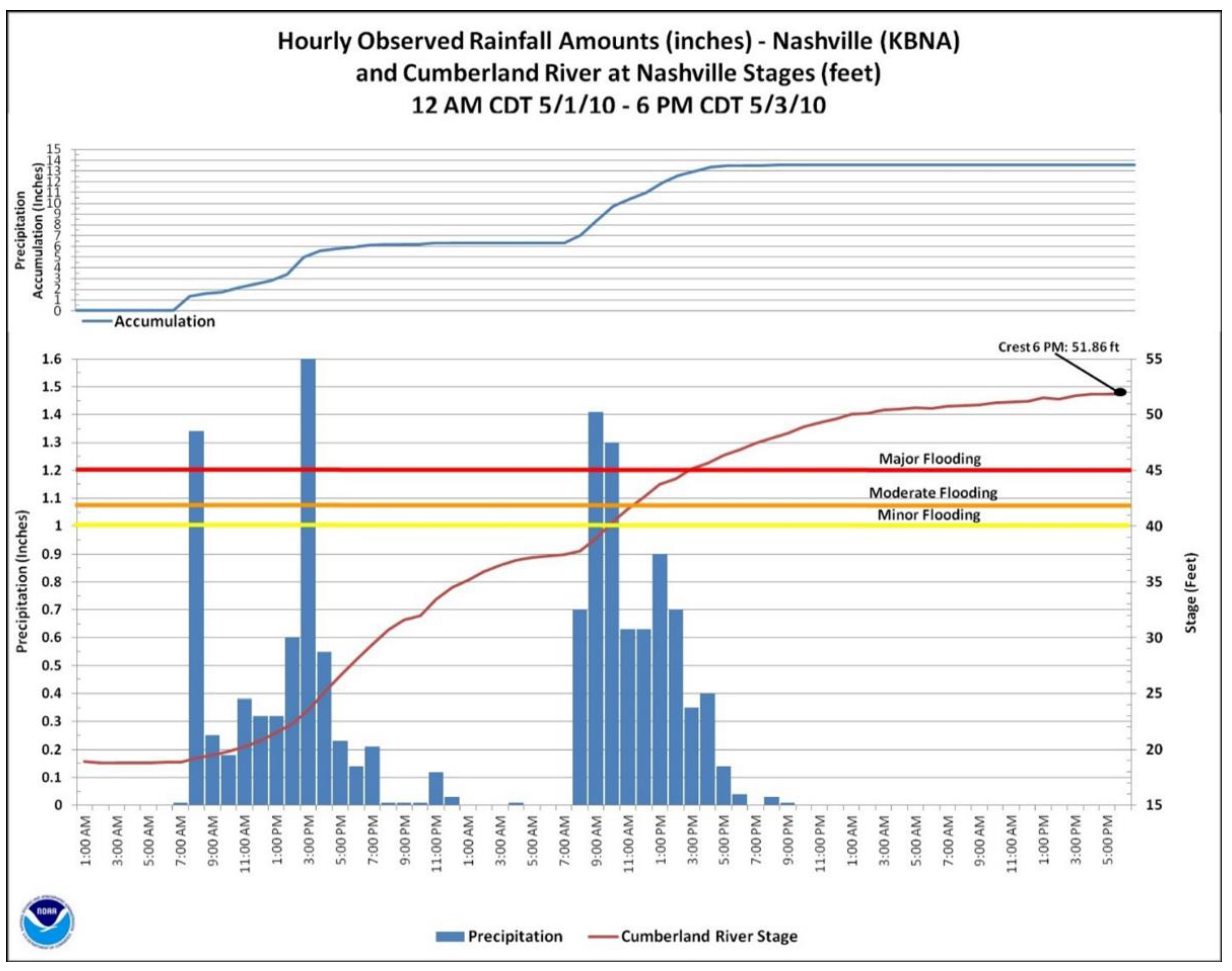
Two episodes of heavy intense rainfall across Kentucky, and western and middle Tennessee, where between 10 to 20 inches of rain fell within 36 h on 1 and 2 May, caused catastrophic flooding events. The heaviest rains fell primary on unregulated portions of the Cumberland River Basin, downstream of the reservoirs containing sufficient flood control storage to help contain the event’s runoff, and mitigate flood damages [24]. Figure 3 shows the total rainfall over 1 and 2 May 2010. Hourly and accumulative rainfall data at the Nashville International Airport are shown in Figure 3. In Nashville, over 13 inches of rain was recorded during a 36-h period; 6.23 inches on 1 May, the 3rd highest 24 h total ever on record; and 7.25 inches on 2 May, which exceeded the previous 24 h rainfall record of 6.60 inches set in September 1979 [24]. The highest weekend rainfall total was reported by the National Weather Service (NWS) Cooperative Observer in Camden, Tennessee, at 19.41 inches.
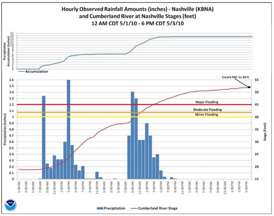
Figure 3.
Hourly and accumulative rainfall at Nashville International Airport from 12:00 a.m. 1 May 2010 to 12:00 a.m., 3 May 2010. [24].
3.2. Operation of Old Hickory Dam during 2010 Flood Event
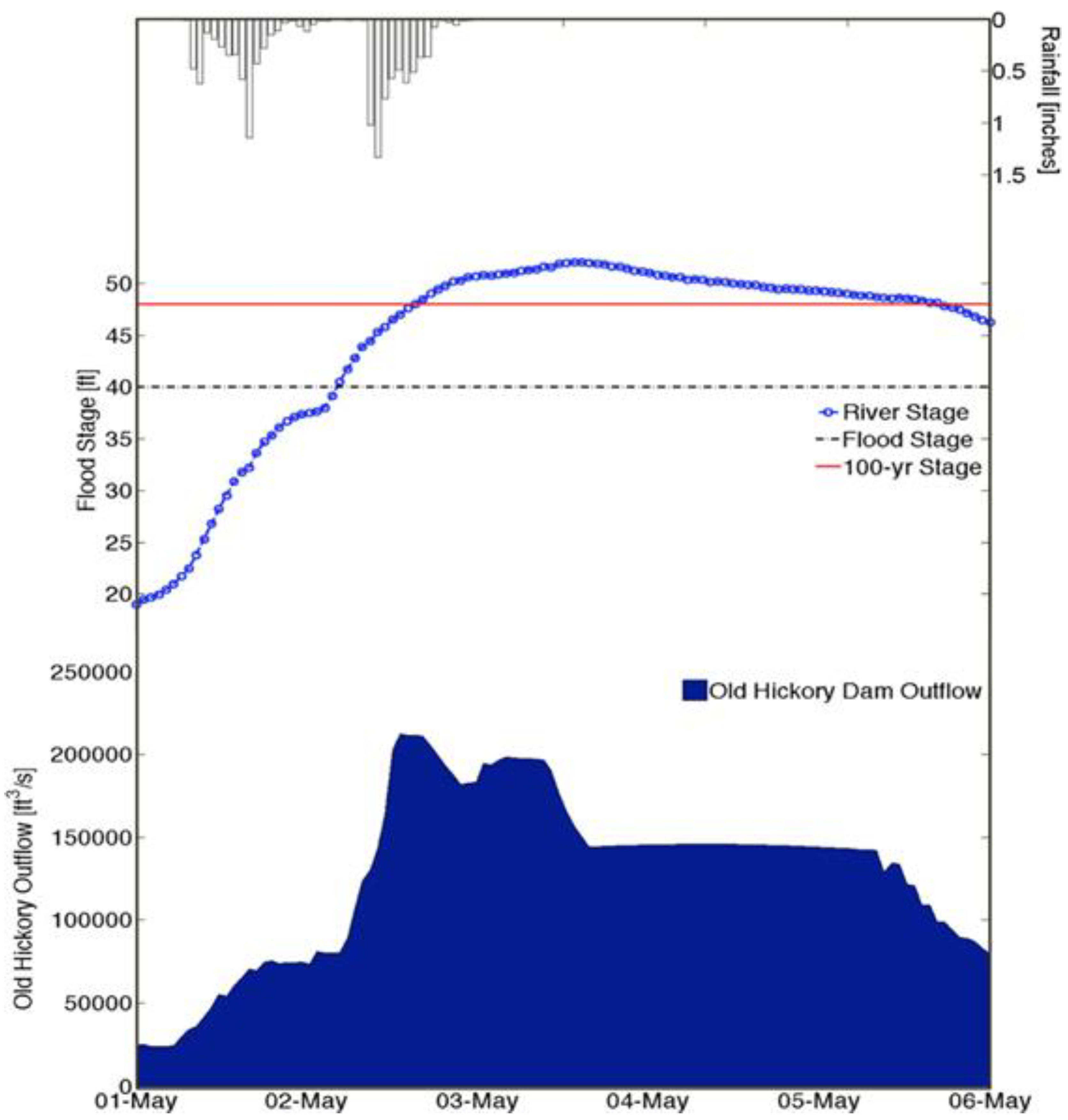
Figure 4 shows the discharge from Old Hickory dam, and the flood stage at the Nashville, Tennessee gage, as a function of time, during the 29 April–7 May 2010 event. The Cumberland River at the Nashville gage rose more than 33 ft to a peak stage of 551.86 ft on 3 May. According to Figure 4, the flood stage of 45 ft was exceeded by 6.86 ft at the Nashville gage. As stated above, had the USACE not ignored the warnings of the composite high-resolution precipitation images for 25–30 April 2010, they could have started drawdowns at Old Hickory days in advance of 1 May.
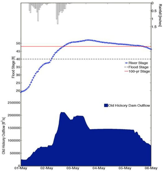
Figure 4.
Discharge at the Old Hickory Dam, and flood stage at the Nashville, TN, USA gage as a function of time during the 29 April–7 May 2010 event. [21].
4. Optimization/Simulation Model for Real-Time flood Control Operation
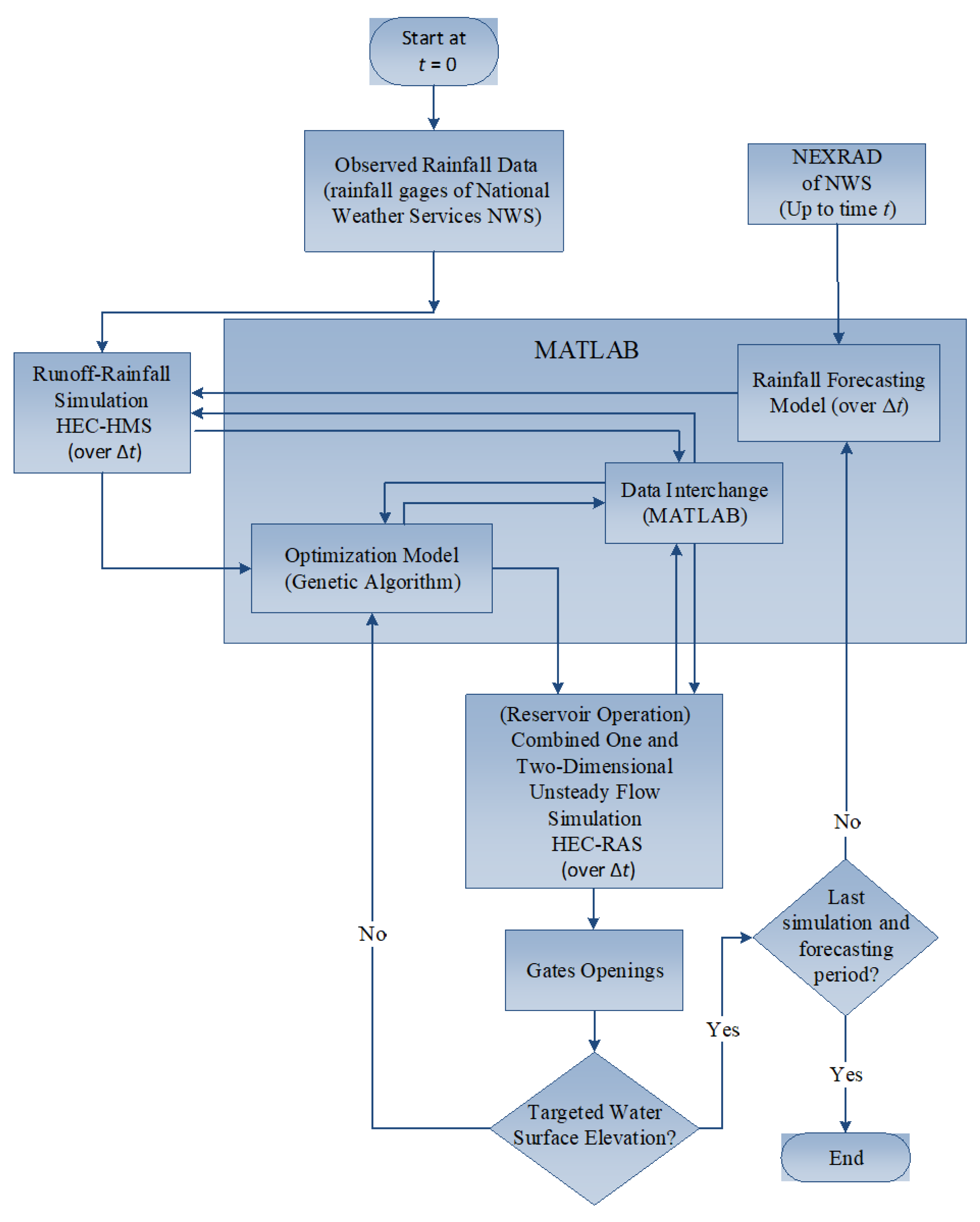
The overall mathematical formulation of the optimization/simulation modeling approach is a real time optimal control problem in which reservoir releases represent the decision variables, and the spillway gate operations represent the state variables. The basic objective of the optimization/simulation model approach, illustrated in Figure 5 for the river-reservoir system operation in real time, is to keep the discharges and/or water surface elevations below specified or target values at various locations during an extreme storm event.
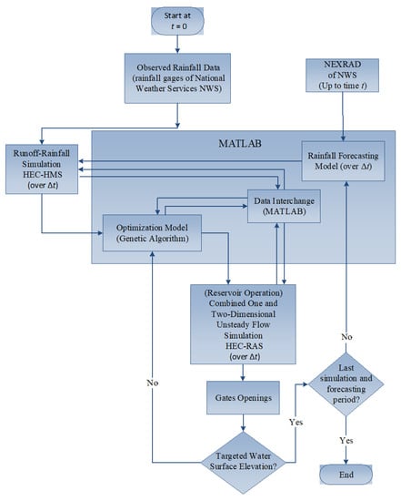
Figure 5.
Basic steps of the optimization/simulation model.
Figure 5 illustrates the over model structure and interconnection of the model components. The optimization/simulation model includes four individual simulation models interfaced through MATLAB that make up the larger simulation model as follows: a short-term rainfall forecasting model, a rainfall-runoff model (HEC-HMS), a one- and/or two-dimensional unsteady flow simulation model (HEC-RAS), and a reservoir operation model, and also illustrates the interconnection of the simulation models, and the genetic algorithm for the solution of the optimization model.
The model formulation in Appendix B is a real-time optimal control problem in which the gate operations defining the reservoir releases are the decision variables. The reduced objective function (unconstrained problem), Equation (A7), is not a well-defined continuous function, and is amenable to GA solutions when the constraints are solved using the simulation models (HEC-HMS and HEC-RAS) each time the constraints need to be solved. Classical optimization methods, such as the simplex method for linear programming, and gradient-based methods for nonlinear programming require well-defined functions. Also, derivatives of functions are required for nonlinear programming. The genetic algorithm does not require derivatives; nor does it require well-defined continuous functions.
5. Model Application to the Cumberland River System
The optimization/simulation model for the real-time operation of river-reservoir systems has been applied to the May 2010 flood event on the Cumberland River system near Nashville, TN, USA. The main objective of this model application is to demonstrate the applicability of the model for minimizing flood damages for an actual flood event in a real-time fashion on an actual river basin. Another objective of the model application is to compare the results of using the three unsteady flow simulation scenarios: one-dimensional, two-dimensional (diffusion-wave model), and combined one- and two-dimensional (diffusion-wave model), utilizing HEC-RAS 5.7 as the simulation model for the unsteady flow. This allowed comparison of the three unsteady flow simulation methodologies used with the optimization procedure. The 100-year stage and water surface elevation at the Nashville, TN, USA gage are 48 ft and 417.52 ft, respectively, and the 100-year discharge is 172,000 cfs.
5.1. Model Set-Up
The approximate watershed area of the Cumberland River system modeled in the USACE HEC-HMS model is 14,160 mi2. The modeled watershed area included head waters of the basin starting in Lechter County, KY, USA, downstream to Cheatham Dam (approximately 30 miles downstream of Nashville). The HES-HMS input was developed by the U.S Army Corps of Engineers (USACE), and consists of 66 reaches and 69 basins. The HEC-HMS was calibrated by the USACE, and validated for the May 2010 storm event by Che [25], who compared the simulated and the observed Dale Hollow reservoir inflow hydrographs for the May 2010 storm event. The USACE one-dimensional HEC-RAS unsteady flow model of the Cumberland River system consisted of 675 cross sections, 8 inline structures, 117 lateral structures, and 1 bridge. Not all the cross-sections and inline structures were modeled herein, as indicated by Figure 6. The USACE calibrated their model, and Che [25] validated the 1D unsteady flow model for the May 2010 storm event using the USACE calibrated values of Manning’s roughness coefficients, and expansion and contraction coefficients. The two-dimensional diffusion wave model built herein was based on the USACE roughness coefficients and other parameters.
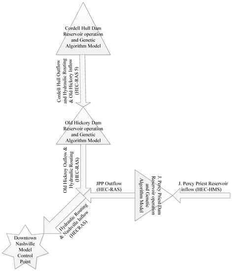
Figure 6.
Portion of Cumberland River system modeled using HEC-RAS.
The portion of the Cumberland River system modeled in the unsteady flow simulations for this application is shown in Figure 6. The purpose of this application is to illustrate how to minimize the flood damages at Nashville by keeping the flood stages (water surface elevations) under the 100-year flood stage of 48 ft at the Nashville Woodland station during a storm event. The operation of Old Hickory Dam was the major component in minimizing flood damages downstream of Old Hickory Dam.
The reservoir regulation and operation rules prepared for the U.S. Army Corps of Engineers Nashville District were used in the model to set the operation rule constraints. The HEC-RAS two-dimensional module based upon the diffusion-wave equations was selected over the full equation approach because the diffusion-wave 2D approach is much faster and more stable. The speed of computations is very important because of the many simulations required in the optimization/simulation approach.
The optimization/simulation model was applied to a portion of the Cumberland River, as shown in Figure 6. The real-time rainfall data source for the May 2010 flood event is the high-resolution grid generated by Next Generation Radar (NEXRAD), which was used for the hydrologic modeling. The portion of the Cumberland River modeled in HEC-RAS using the two-dimensional approach is from Old Hickory Dam downstream through Nashville to Cheatham Dam.
5.2. Solution Process
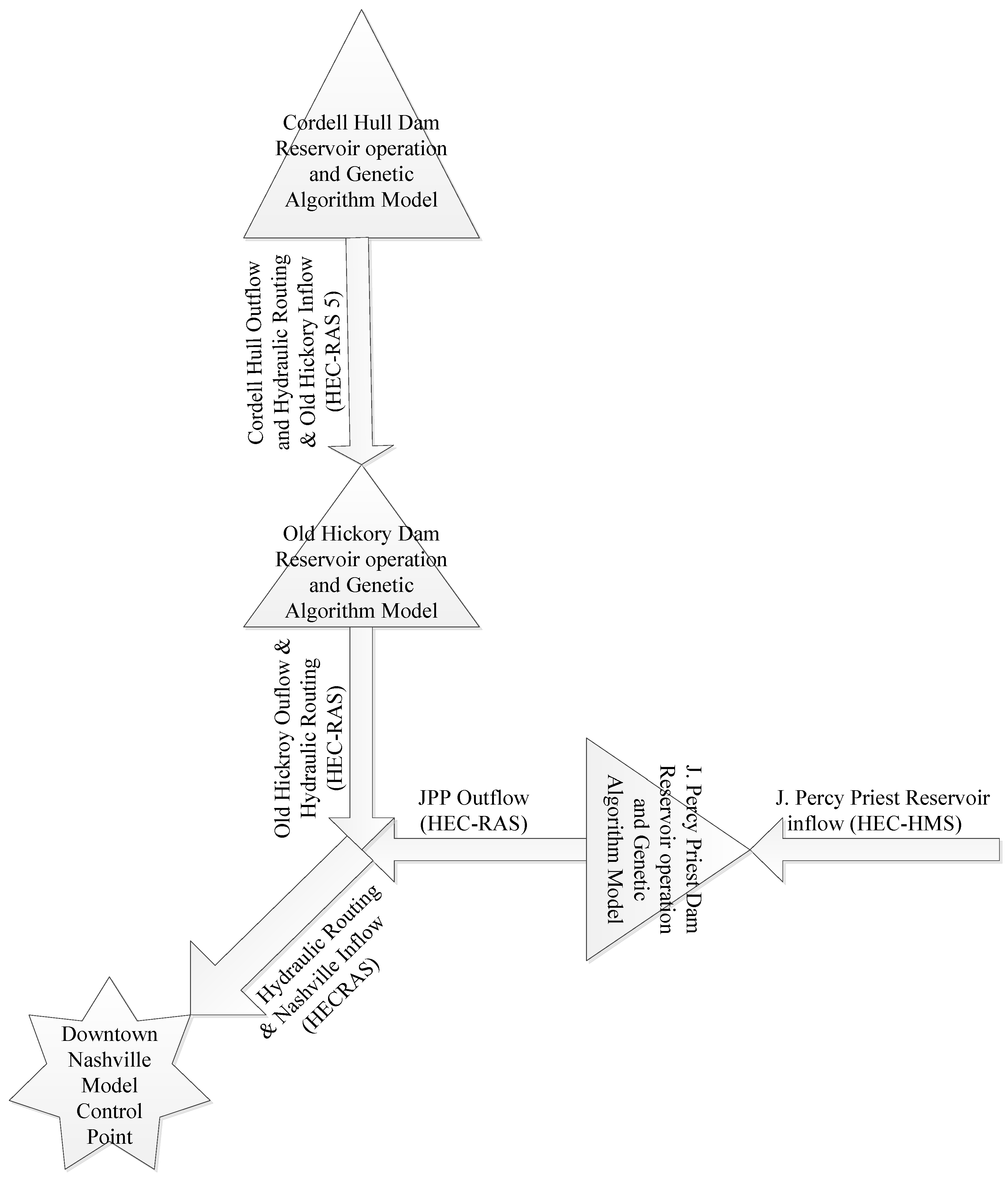
The solution process starts with the available actual rainfall data up to time t for the area upstream from the Cordell Hull and J. Percy Priest reservoirs. The MATLAB code sends the actual rainfall data to the U.S. Army Corps of Engineers HEC-HMS model to simulate the rainfall runoff process. The discharge hydrograph from the HEC-HMS model becomes the inflow for the Cordell Hull Reservoir. The inflow hydrograph enters the optimization and operation model to determine the optimal releases from the Cordell Hull dam gates. The model now calls HEC-RAS to route the releases up to Old Hickory Reservoir, where it is considered as the inflow to the Old Hickory Reservoir. Once the inflow hydrograph for Old Hickory Reservoir is determined, the operation and optimization model determine the releases for the next 4 h from the Old Hickory Dam. The optimization model employs the genetic algorithm in MATLAB to generate the initial solution considering all the operating rule constraints, described previously, and calls the unsteady flow model (HEC-RAS) to test the generated solutions, which is the time series of the Old Hickory gates openings. The unsteady flow model routes through the gate openings at both reservoirs downstream to the Woodland station at Nashville. The process continues iteratively until the objective function is satisfied. Then, the model steps to the next time t + Δt. The model continues to run until the last Δt of the storm.
The optimization model (GA) uses the last generation or the optimal solution at time t as the initial solution for time t + Δt to reduce the search time of the next step. This saves around 17 min of computation time for each iteration for this application. This computational time saving may be very valuable in real-time river-reservoir operation under flood conditions.
The most important factor that could limit this model is the simulation time for the unsteady flow calculations for each time step, and for each iteration of the GA of the optimization. Shorter simulation times allow the optimization model (GA) to increase the number of objective function evaluations, which means the number of times that the simulator (HEC-RAS) is called. Producing a faster simulation model taking into consideration the accuracy of the mode was a priority of this research. The most time-consuming parts of the overall model application are the unsteady flow simulations. Every factor that may affect the time of simulation time, including the mesh size, computation interval, mapping output, and even hydrograph interval, was considered.
To obtain faster two-dimensional unsteady simulations, the diffusion wave model was utilized using the current version of HEC-RAS instead of the full two-dimensional simulation. The portion of the Cumberland River modeled in HEC-RAS using the one- and two-dimensional approaches is from Old Hickory Dam downstream through Nashville to Cheatham Dam.
5.3. Operations of Old Hickory Dam
The time series of the gate openings at Old Hickory are the decision variables of the optimization/simulation model, including the constraints of reservoirs, such as: gate openings/discharge relationships, operation rules of the gates under flooding conditions, the hourly rate of change of gate opening, and the reservoir stage/storage relationship. The model determines the operation for each forecasting period Δt, which is 4 h for the Cumberland River.
The actual operation of the Old Hickory Dam during the event started the releases at night on 1 May 2010, despite the forecast warnings from severe rainfall several days in advance. Using the optimization/simulation model with the available forecasting information could have helped the U.S. Army Corps of Engineers make decision at Old Hickory Dam before the actual storm entered the Old Hickory Reservoir in a timely manner.
5.4. Unsteady Flow Scenarios
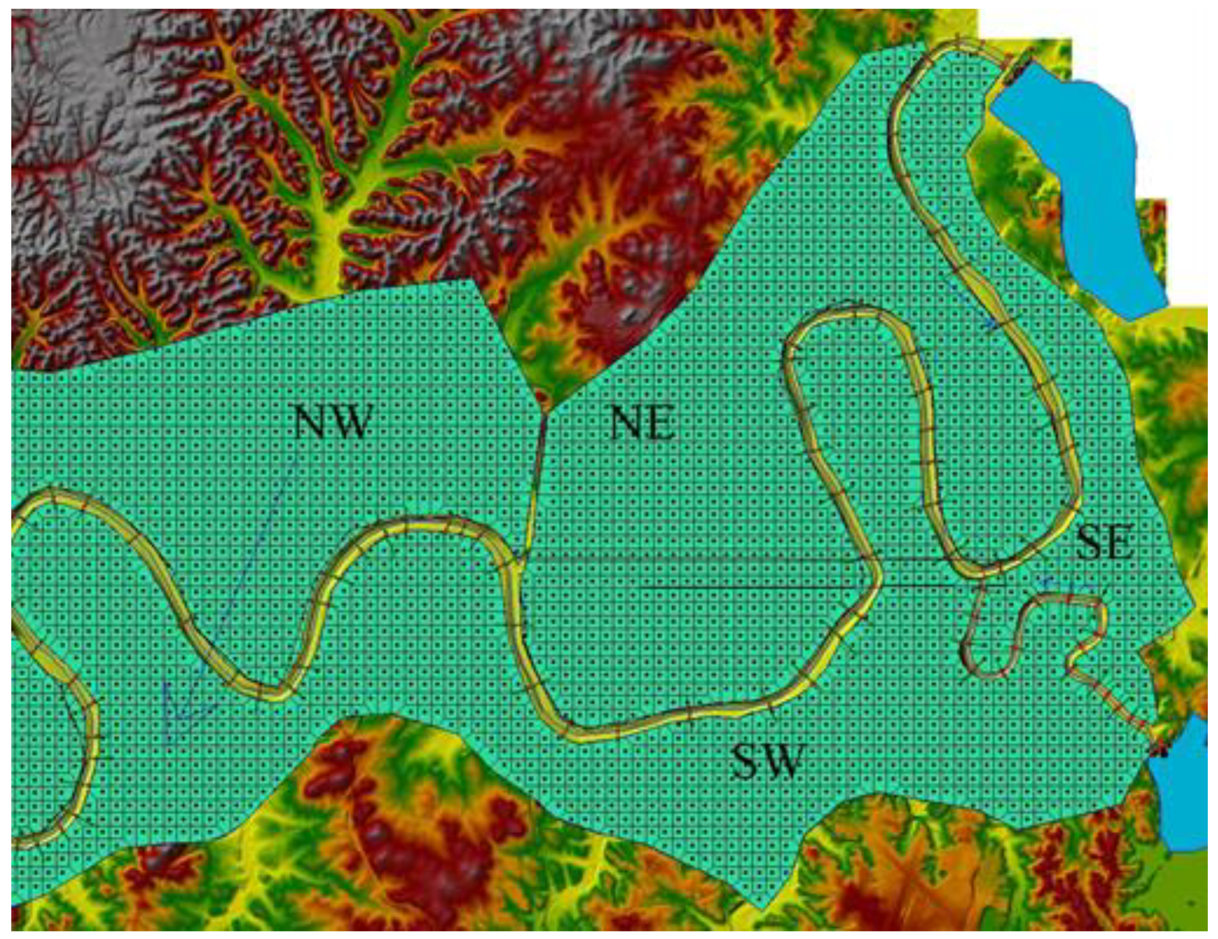
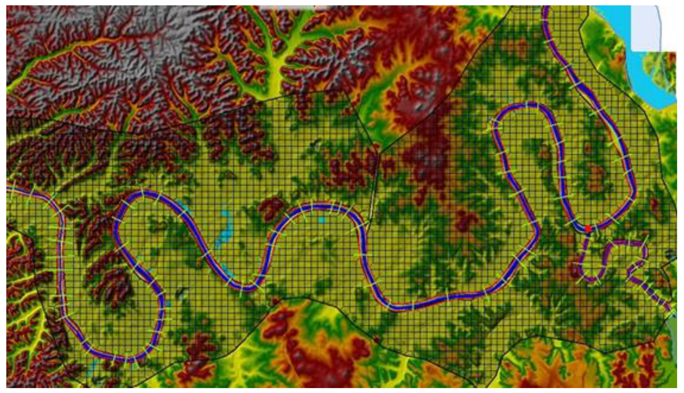
Three scenarios were adopted to simulate the unsteady flow for the May 2010 flood event. The first scenario uses combined one- and two-dimensional unsteady flow modeling, in which the Cumberland River, Nashville, TN, USA, reach has been model using the one dimensional model, whereas its flood plain was modeled using two-dimensional unsteady flow simulation. The two-dimensional area was divided into four sub regions, two on the north side of the river reach, and two on the south side, and as NE, NW, SE, and SW, as shown in Figure 7. These sub-areas were gridded into 832, 1068, 235, and 1208 cells, respectively. The total area of these cells that cover the two-dimensional modeling is around 106 square miles. The input spacing into the 2D flow area editor for the generation of cells is 1000 feet × 1000 feet.
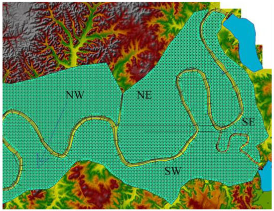
Figure 7.
Combined one- and two- dimensional areas downstream of Old Hickory and JPP (the blue arrow indicates the general flow direction from NE to SW).
The other components include: two reaches, cross sections, storage areas, laterals, inline structures, and one junction. The Nashville reach connects Old Hickory Dam at the upstream to Cheatham Dam at the downstream using 76 cross sections over the total length of 51 miles. The other reach is the Stone River reach, which links the J. Percy Priest Lake to the Nashville reach via 22 cross sections. The cross sections were extracted from the terrain model, and modified with the actual cross sections surveyed by U.S. Army Corps of Engineers. The terrain does not accurately represent the actual bathometry of a river reach because the LIDAR technology does not have the ability to penetrate water surface elevations.
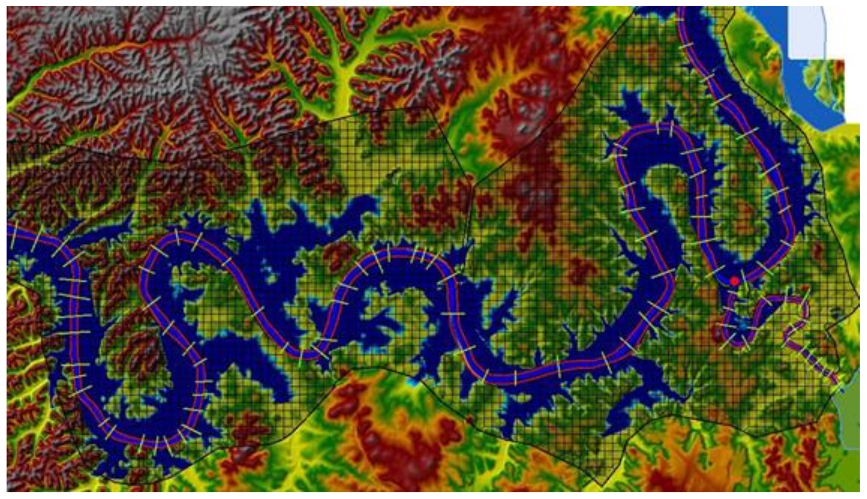
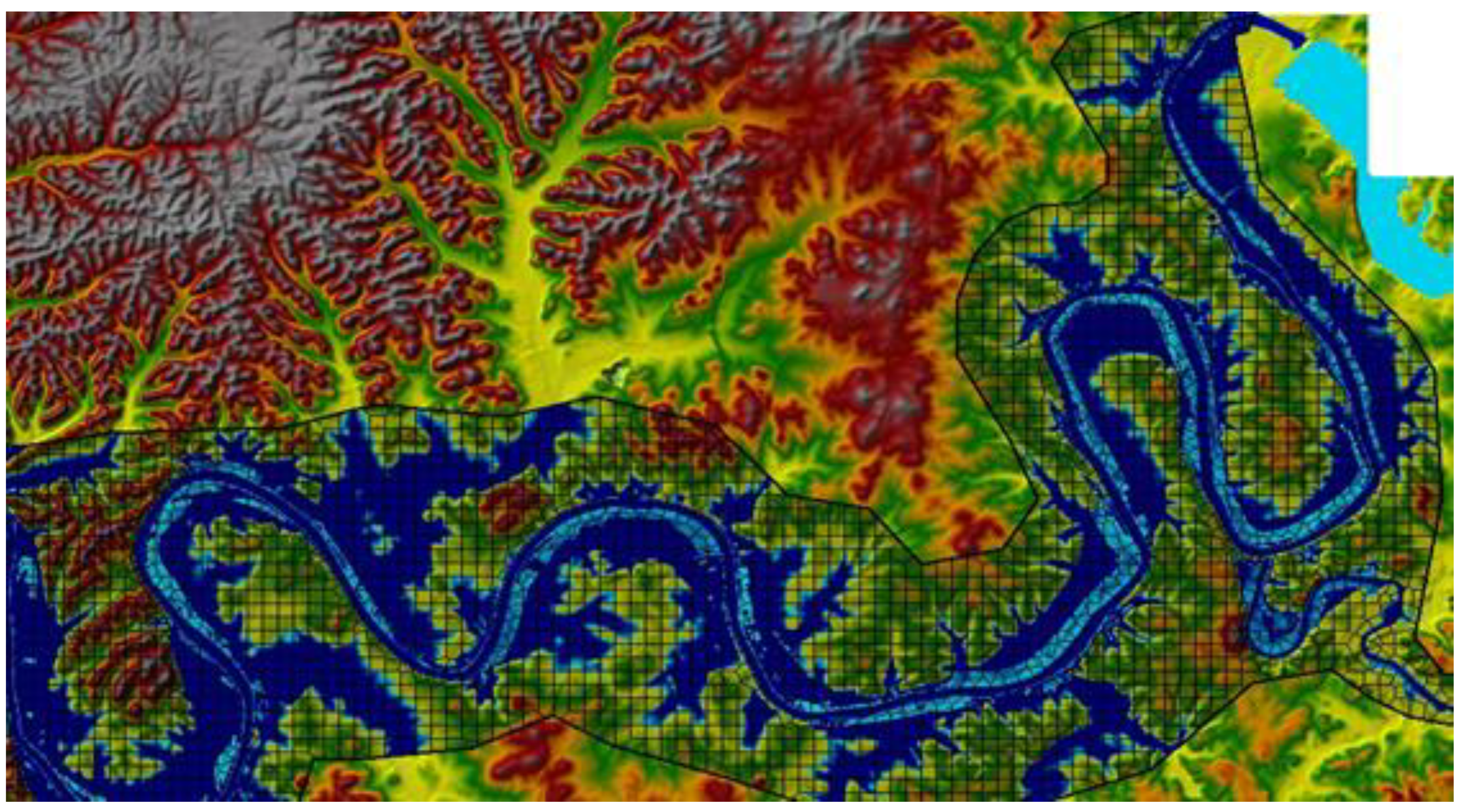
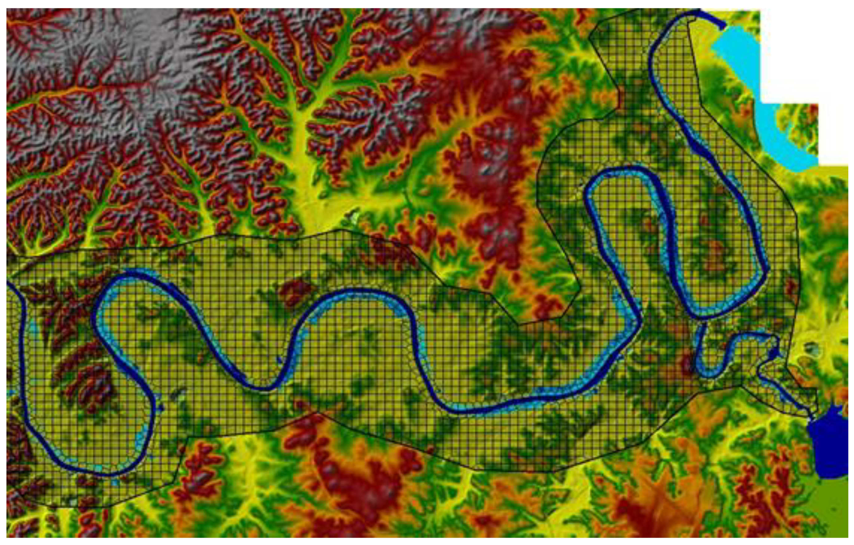
Each of the two-dimensional areas is connected to the river reach (one-dimensional area) through a lateral structure. Figure 7 also shows the combined one- and two-dimensional areas downstream of Old Hickory and JPP, where the blue arrow illustrates the general flow direction from NE to SW. Each iteration of the combined one- and two-dimensional model takes 5 to 6 min to run one unsteady flow simulation for this portion of the Cumberland river system shown in Figure 8, which is a simulated inundation map developed using the combined one- and two-dimensional approach in HEC-RAS for the May 2010 Flood Event. Figure 9 is a simulated inundation map developed using only the two-dimensional approach in HEC-RAS for the May 2010 flood event.
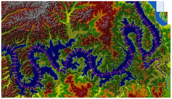
Figure 8.
Simulated inundation map using combined one- and two-dimensional approach in HEC-RAS for the May 2010 flood event.
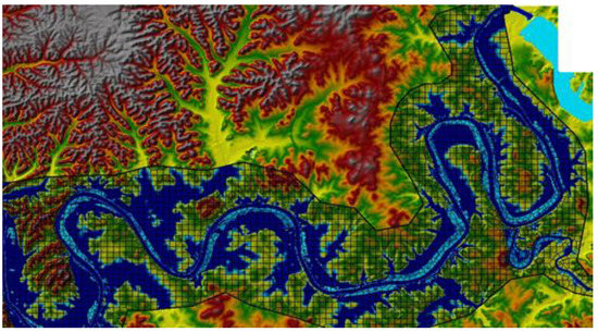
Figure 9.
Simulated flooding (inundation areas in blue) Using the HEC-RAS two-dimensional approach for the May 2010 flood event.
The second scenario uses only the two-dimensional unsteady flow modeling downstream of Old Hickory Dam. One of the problems in using only the two-dimensional approach is that terrain data does not often include the actual terrain underneath the water surface in the channel region (river bathometry) because LIDAR processing is not capable of penetrating the water surface elevation [26]. As a result, many HEC-RAS users do not prefer using only the two-dimensional approach. Thus, the terrain model of the only two-dimensional of the Nashville reach has been modified through RAS Mapper by the creation of a terrain model of the channel region only from the cross sections surveyed and measured in field by the U.S Army Corps of Engineers, and the cross-section interpolation surface.
The second scenario was set up with only a two-dimensional area enhanced with 2D break lines along the river reach to enforce the mesh generation tools to align the computational cell faces along the break lines. The two-dimensional flow element connected directly to the storage areas, Old Hickory Reservoir and J. Percy Priest Lake, using the storage area and 2D area connections that allow the input of the data of hydraulic structures, such as gates and weirs, as it is set in normal inline structures to control the flow between the two elements of area. The 2D area was divided into 3211 cells, with a maximum cell area of 2.2 M square foot, minimum cell area of 439 K square foot, and the average cell area of 974,165 square feet. The total area of these cells that cover the two-dimensional modeling is around 112.2 square miles. The input spacing of the 2D flow area editor for the generation of these cells is 1000 ft × 1000 ft, which is considered relatively coarse; the reason behind this is that any finer cell size will take a longer time to run the simulation, which may result in exceeding the lead time in which the decision for reservoir releases must be made. However, the model ran well with the suggested spacing.
Due to the limited availability of the LIDAR that were used to develop the terrain model for Nashville, the area upstream of Old Hickory Dam was modeled using only 1D unsteady flow simulation. The terrain resolution used in the model was 2.5 ft × 2.5 ft, which is considered high enough to produce more accurate and detailed hydraulic table properties for two-dimensional computational cells and cell faces.
5.5. Comparison of Simulation Scenarios
All the simulation scenarios showed close simulation results for the flood situation at Nashville during the May 2010 flooding event. The optimization and the combined one- and two- dimensional simulation, as well as the one-dimensional model, successfully kept the discharge at or below 171,809 cfs after 64 iterations. This peak discharge is only a little higher than the one-dimensional result of the simulation-optimization model, with 171,076 cfs [25].
Each simulation run of the combined one- and two- dimensional simulation required 6 to 8 min for the 4 h time interval, for which the optimization model could perform around 23 iterations. The inundation map of the observed water surface of May 2010 for Nashville simulated using the combined one- and two-dimensional simulation approach is depicted in Figure 10.
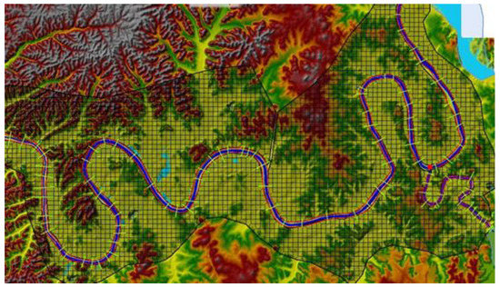
Figure 10.
Optimized inundation area (shown in blue) using combined one- and two-dimensional approach in HEC-RAS for the May 2010 flood event.
Contrary to expectations, the two-dimensional simulation model linked with the optimization model resulted in peak discharges that did not exceed 169,694 cfs during the entire period of simulation of the May 2010 storm event. This two- dimensional unsteady flow model ran faster than the combined one- and two-dimensional model, so the optimization model had more time to improve the solution. The reason why the previous model is slower than this one is because of the connection between the two-dimensional and one-dimensional areas, which is modeled as very long lateral structures.
The observed water surface elevations in the form of an inundation map for the May 2010 event at Nashville using the two-dimensional unsteady flow modeling approach (HEC-RAS) is depicted in Figure 11, which shows the flood inundation area resulting from the application of the optimization/simulation model using the two-dimensional approach.
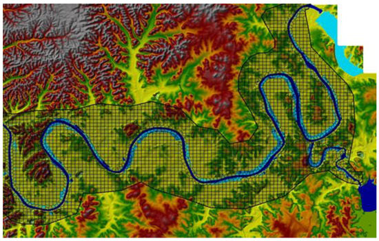
Figure 11.
Optimized flooding (inundation areas in blue) using the two-dimensional approach in the optimization/simulation model for the May 2010 flood event.
Each simulation run of the combined one- and two-dimensional simulation required 6 to 8 min, so that for a 4 h time span (Δt) between a change in possible gate operations, 30 to 40 simulations could be performed on a PC. Obviously, for a faster computer, many more simulations could be performed, but most likely would not need to be performed.
5.6. Comparison of Optimizied Operations
The basic objective of the optimization-simulation model for the river-reservoir system operation in real-time is to maintain the discharges and water surface elevations below specified or target values during an extreme storm event. For this application, the 100-year frequency values at the Woodland gaging station in Nashville, Tennessee are 417.52 ft for the water surface elevation, and 172,000 cfs for the discharge. For the optimization/simulation applications, the water surface elevation was the constraint on the optimization. A comparison is now presented of the resulting optimized operations with the actual operations by the U.S. Army Corps of Engineers (USACE) during the May 2010 flooding event.
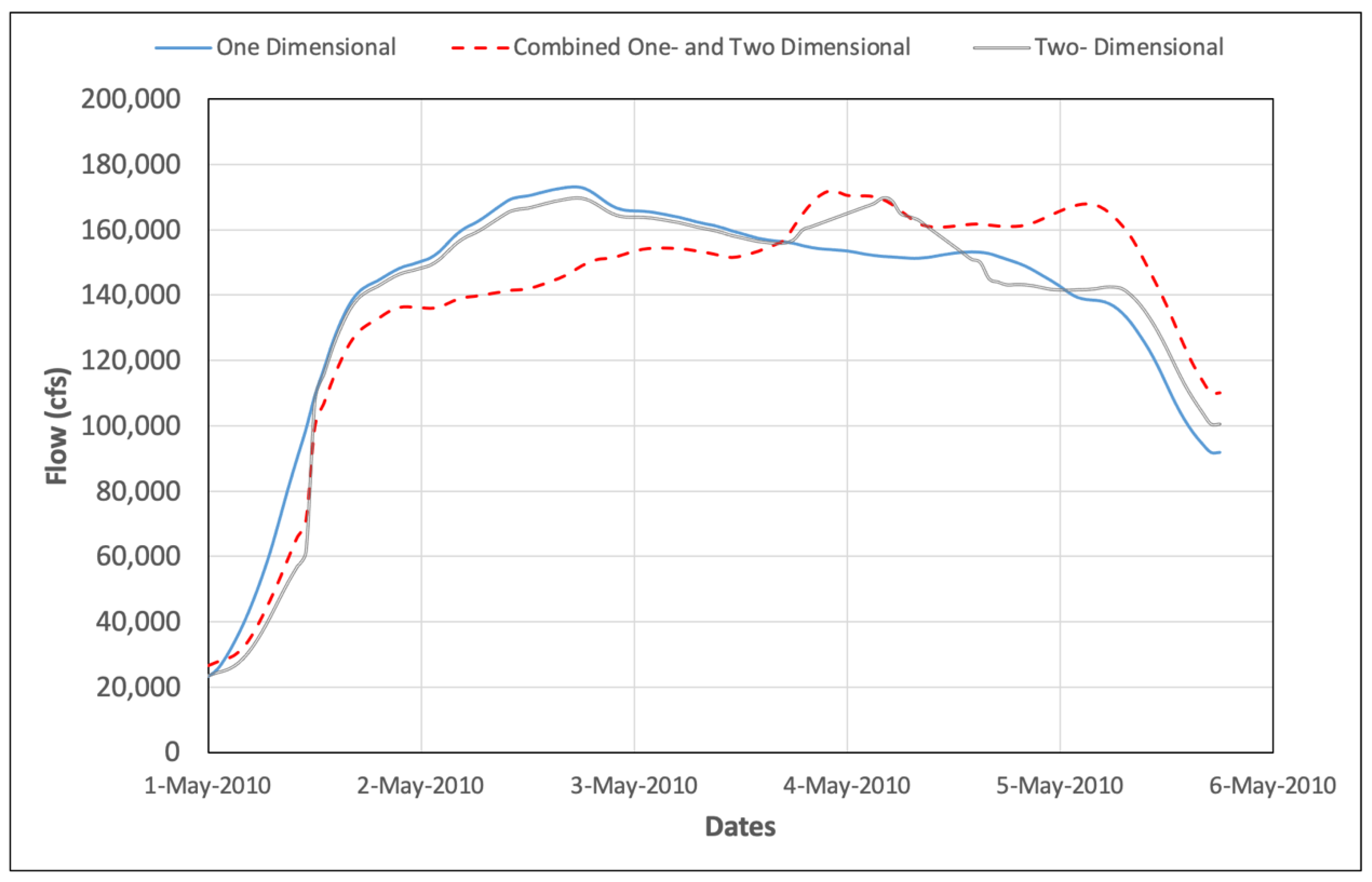
Figure 12 compares the optimized discharges at Nashville for the May 2010 flood event of each of the three unsteady flow modeling approaches. Each of the three optimized discharges for the unsteady flow routing models at the gaging stations are below the 100-year water surface elevation, but not the discharge of 172,000 cfs. However, the peak discharges from the simulations were 172,907 cfs for the 1D simulation, 171,792 cfs for the combined 1D and 2D simulation, and 169,682 for the 2D simulation approach.
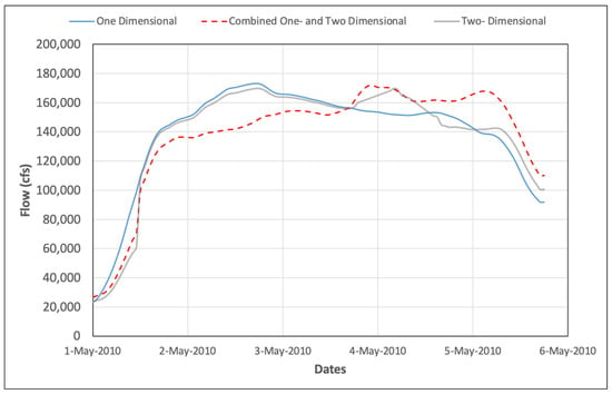
Figure 12.
Optimized discharges at Nashville for the May 2010 flood event for three scenarios of unsteady flow modeling.
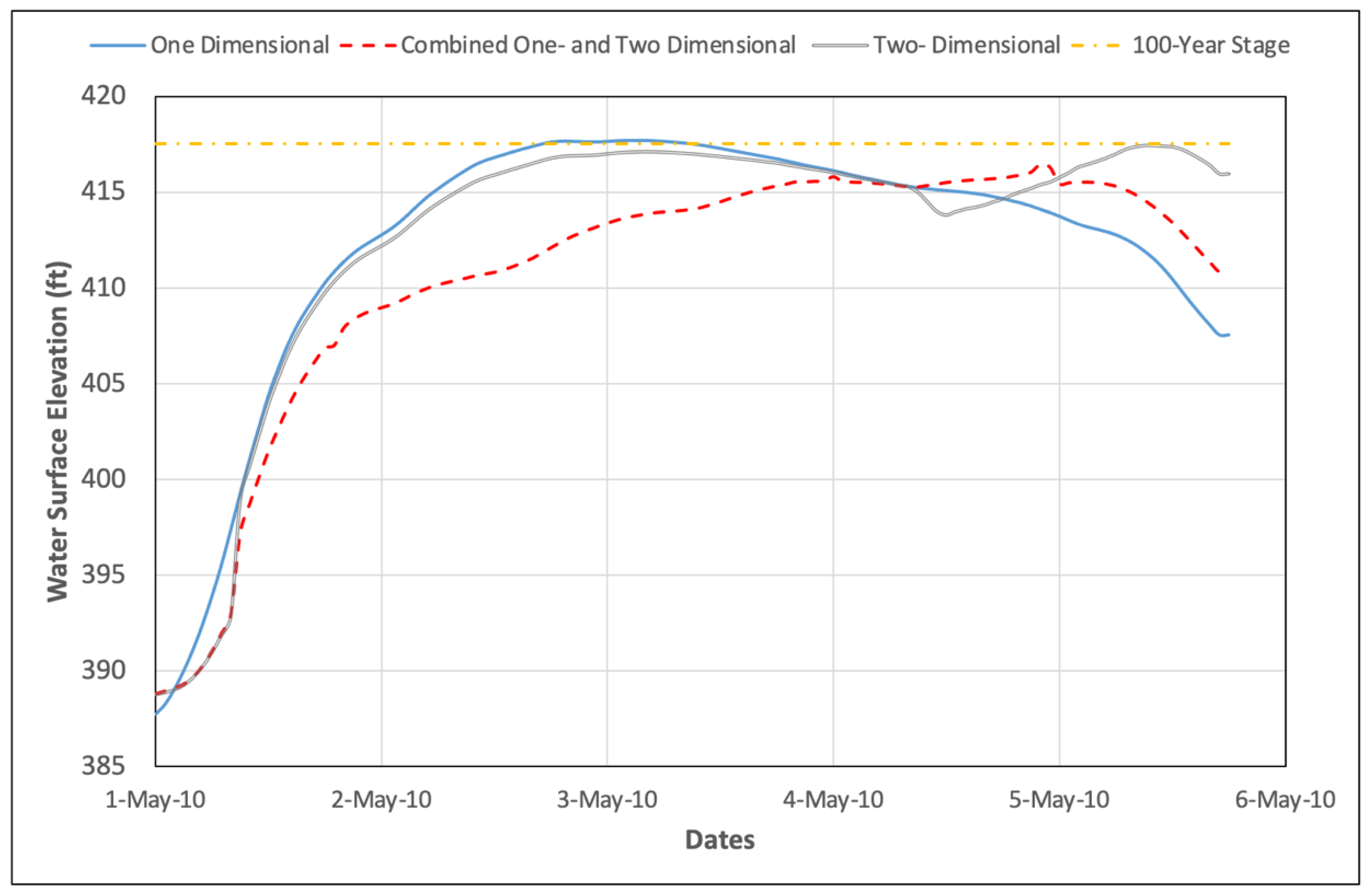
Figure 13 compares the 100-year and optimized water surface elevations for the May 2010 flood event at Nashville for the three scenarios of unsteady flow modeling. Note in the figure that the 100-year water surface elevation is shown with all the simulation water surface elevations at or below the 417.52 ft elevation (100-year).
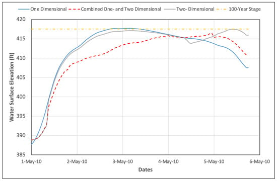
Figure 13.
Comparison of 100-year and optimized water surface elevations for the May 2010 flood event at Nashville for three scenarios of unsteady flow modeling.
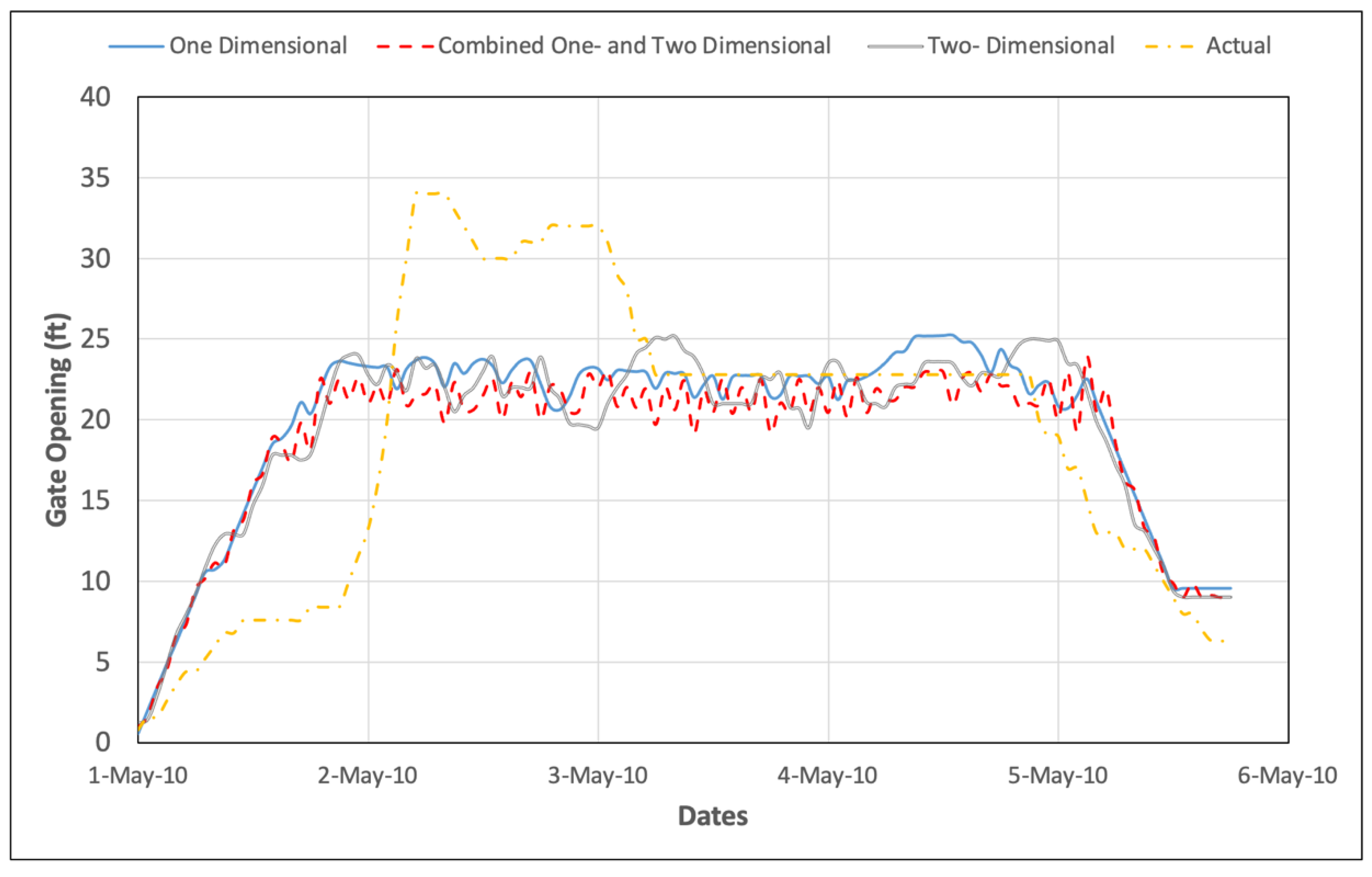
Figure 14 illustrates the differences between the optimized operations of flood gates at Old Hickory, which were all opened the same distance, as compared to the actual operations, which were all opened at the same distance. Obviously, the actual USACE operation of the gates waited too late to start opening the gates, resulting in peak gate openings of 34 ft as compared to optimized maximum gate openings of 25.23 ft for the 1D simulation, 25.2 ft for the combined 1D and 2D simulation, and 23.9 ft for the 2D simulation.
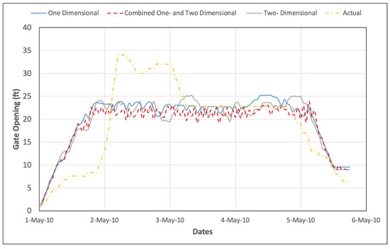
Figure 14.
Optimized and actual operations (flood gate openings) of the Old Hickory Dam during the May 2010 flooding event.
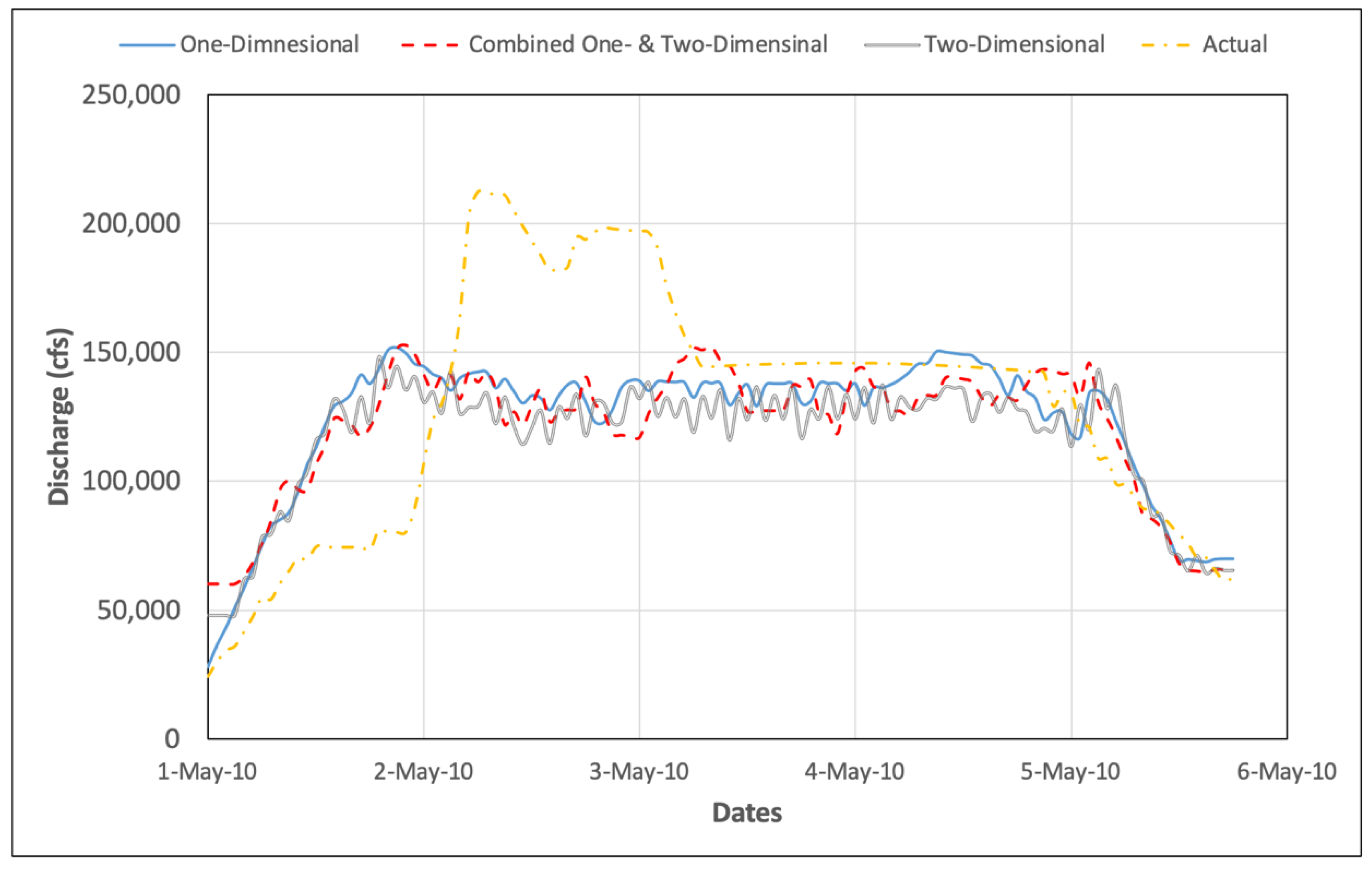
Figure 15 compares the actual releases with the optimized releases from Old Hickory Dam during the May 2010 flooding event. The actual peak release was 212,260 cfs, and the optimized peak releases were 144,860 cfs for the 1D unsteady flow model, 149,536 cfs for the combined 1D and 2D unsteady flow model, and 148,052 cfs for the 2D unsteady flow model. Obviously, the very large releases from the Old Hickory Dam resulted in the very large flows in Nashville compared with the optimized discharges.
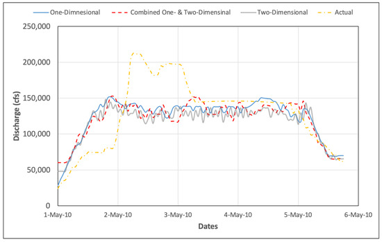
Figure 15.
Optimized and Actual Releases at Old Hickory Dam during May 2010 Flooding Event.
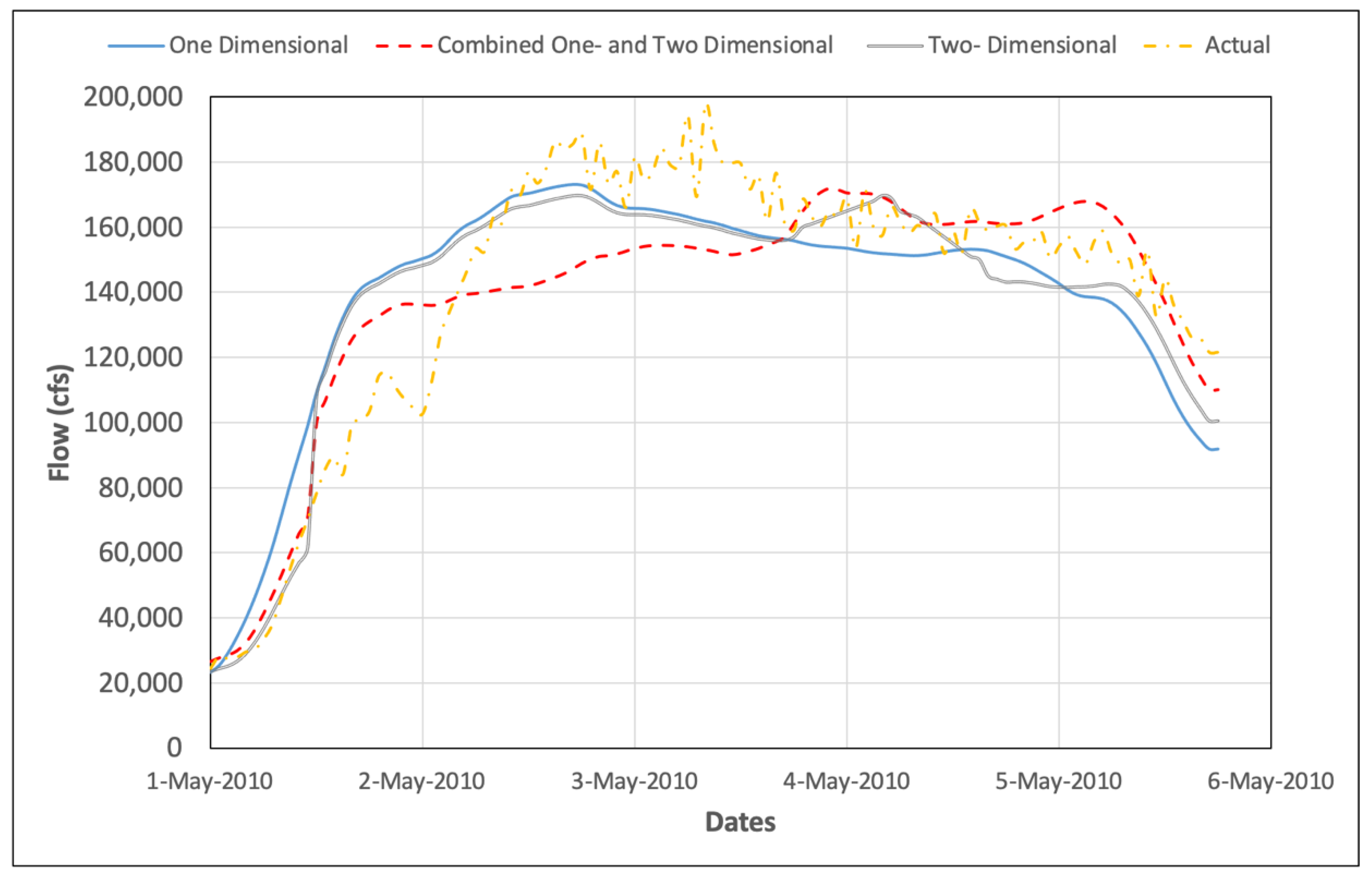
Figure 16 compares the optimized and actual flows at Nashville during the May 2010 flooding event. The actual peak discharge at Nashville was 197,865 cfs as compared to the optimized peak discharges of 171,542 cfs for the 1D unsteady flow model, and 169,000 cfs for the combined 1D and 2D model.
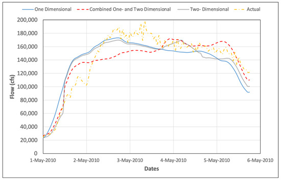
Figure 16.
Optimized and actual flows at Nashville during the May 2010 flooding event.
5.7. Discussion
The Cumberland River application of the optimization/simulation for optimal operation of the gates at Old Hickory Dam only considered one control point, which was located at Nashville. This was because the only recorded water surface elevations for the flood event were at Nashville for the purposes of the application. However, during an actual real-time application for a river-reservoir, several control points may need to be considered, making the combined one-dimensional and two-dimensional routing more accurate and more applicable, especially if control points were located in the floodplain, and not just on the mainstem of the river.
6. Conclusions
An optimization/simulation model has been developed to determine the optimal operation of gates (reservoir release schedules) before, during, and after flooding events. This model has been developed in the framework of an optimal control problem discussed in detail by Mays [27] for various types of hydrosystem operation problems. The proposed optimization/simulation model consists of four individual models (interfaced through MATLAB) that make up the larger simulation model created in this chapter, and are listed as follows: a rainfall forecasting model, a rainfall-runoff model, a one and/or two-dimensional unsteady flow model, and an reservoir operation model with a genetic algorithm optimization model. The two-dimensional optimization/simulation approach uses the U.S. Army Corps of Engineers Hydrologic Engineering Center HEC-HMS and the HEC-RAS 5.0.3 version. The reservoir operation model is optimized using the genetic algorithm within MATLAB. Although the genetic algorithm requires many function evaluations (simulation runs of HEC-RAS) to reach an optimum solution, the approach has the significant benefit of being able to interface with simulators.
The HEC-RAS program allows the modeler to choose either the full two-dimensional equations or diffusion wave equations in two-dimensions to solve the model, which are set as the default. In general, the two-dimensional diffusion wave equations have reduced computation times, and have more stable properties than using the full two-dimensional equations. Even though a wide range of modeling situations can be precisely modeled with the two-dimensional diffusion wave equation, users can always test if the full two-dimensional equations are required for their specific situation by creating another run.
The complete optimization/simulation model was applied to a portion of the Cumberland River System in Nashville, TN, USA for the flooding event of May 2010. The objective of this application is to demonstrate the applicability of the model for minimizing flood damages for an actual flood event in real-time on an actual river basin. The purpose of the application in a real-time framework would be to minimize the flood damages at Nashville, TN, USA by maintaining the flood stages under the 100-year flood stage. This application also compared the three unsteady flow simulation scenarios: one-dimensional, two-dimensional, and combined one- and two-dimensional unsteady flow.
The model application successfully determined real-time operations that would have kept the flood water surface elevations at the downstream control point in Nashville below the 100-year return period, and kept the gate openings at the Old Hickory Dam and Lock at just over 25 ft, as compared to the 34 ft used in the actual operation, which placed the dam operation in an emergency situation that could have resulted in major losses at the dam. The actual operation did, however, cause significant flows and water surface elevations well above the 100-year values in the Nashville area, causing major damage. The results of the application show the importance of the real-time optimization/simulation model.
Author Contributions
The model formation and incorporation, formal analysis, investigation, resources, data curation, and writing of the original draft were performed by the first author—H.A.-S. The conceptualization, proposing the methodology, writing the review, and editing were performed by the second author—L.W.M. The research plan was supervised, and the final draft was reviewed and edited by the third author—D.C. All authors have read and agreed to the published version of the manuscript.
Funding
This research received no external funding.
Institutional Review Board Statement
Not applicable.
Informed Consent Statement
Not applicable.
Data Availability Statement
Data and materials will be provided when request upon.
Conflicts of Interest
The authors declare that they have no known financial interests or personal relationships that could have appeared to influence the work presented.
Appendix A. What Happened at Old Hickory Lock and Dam and Downstream?
The flood of May 2010 resulted in a peak project headwater of 451.45 ft above msl, and required an estimated maximum discharge of 212,260 cfs to control reservoir levels. Prior to the flood of May 2010, based upon National Weather Service (NWS) rainfall forecasts, the pool elevation above Old Hickory Lock and Dam was lowered by approximately only 0.5 ft. This adjustment was within normal reservoir levels. Beginning at 12 p.m. on Saturday, 1 May, spillway discharges were initiated at Old Hickory Lock and Dam at a rate of approximately 5000 cfs/h, until a total flow of 75,000 cfs was reached at 11 a.m. on the same day. This discharge remained constant in an effort to allow local inflows to recede downstream, until 1 a.m. on Sunday, 2 May, when a series of spillway discharge increases were required as a result of rapidly increasing reservoir elevations. Spillway discharge increases as often as every 15 min, and as much as 10,000 cfs each, were necessary to prevent the upstream lock wall from being overtopped. Had the pool climbed 0.55 ft higher, it would have overtopped the upstream lock wall, resulting in flooding of the powerhouse, and requiring complete evacuation of the dam. It has been estimated that such an event would have resulted in a flood crest approximately 4 ft higher in Nashville than was experienced.
At 9 p.m. on Sunday, 2 May, the first spillway discharge reductions were made to manage the crest at Nashville that was forecast at that time to occur at 1 a.m. on Monday, 3 May. Additional reductions were made throughout the night; however, at 3 a.m. on Monday, 3 May, spillway discharge increases were again required as large discharges from Cordell Hull and local uncontrolled runoff had pushed the reservoir dangerously high. In an effort to reduce the flood crest through Nashville, and protect the lone remaining water treatment plant for the city, spillway discharges were reduced, beginning at 1 p.m. on Monday, 3 May. Between 1 p.m. and 5 p.m., the total discharge from Old Hickory Dam was reduced from 196,500 cfs to 144,200 cfs. These spillway gate settings were held until 9 a.m. on Wednesday, 5 May, when a series of spillway discharge reductions were made in response to steadily declining inflow to the project. By the end of the day on Thursday, 6 May, Old Hickory Lock and Dam was back within its normal operating range. Flood damages sustained at Old Hickory Lock and Dam were estimated at $11.5M.
This event caused severe flooding in Nashville and surrounding areas. Many lives were lost, and many homes and businesses were flooded and ruined. The rainfall occurred during the weekend of 1–2 May 2010. According to the National Weather Service, 13.57 inches of rain was recorded in just a 36-h period. The rainfall total doubled the previous 48-h rainfall record in Nashville. Twenty-six lives passed away as a result the flooding in Tennessee and Kentucky, including 11 in the Nashville area. Nearly 11,000 properties were damaged or destroyed by the flooding, and 10,000 people were displaced from their homes. The flood caused over $2 billion in private property damage, and $120 million in public infrastructure damage in Nashville. One year after the event, The Tennessean, citing the Nashville, TN, USA Area Chamber of Commerce, reported that 300 to 400 businesses remained closed, and 1528 jobs were “very unlikely” to return [28].
The U.S. Army Corps of Engineers (USACE) and the National Weather Service (NWS) took heat in congressional hearings after Nashville was caught off guard by the rapid rise of the Cumberland River, which crested almost 12 ft above flood stage. The USACE apologized for its handling of the crisis, and the NWS admitted that it did not clearly communicate the magnitude of the flood [28].
Appendix B
The objective function is to minimize the flow rate and/or water surface elevations at specified control points, which minimizes the water surface elevations throughout the simulation time so the objective function is expressed as:
where is the flow rate time-series or water surface elevation time series at the control-point locations (x, y) of the river-reservoir system that affects the control point location in the downstream two-dimensional area; is the penalty coefficient at control points (cells); and x, y, and t are spatial and temporal indices, respectively. The objective function allows multiple control locations.
Constraints and limitations must also be satisfied, which are classified into four main types: hydrologic constraints, hydraulic constraints, bound constraints, and operation constraints.
Hydrologic constraints represented by the rainfall-runoff relationships defined by the sub-basins areas, rainfall losses due to canopy interceptions, depression storage, soil infiltration, excess rainfall transform methods, watershed runoff routing method, internal boundary conditions, and initial conditions that depict the rainfall-runoff process in different components of a watershed system:
where is the matrix of precipitation data in the system; is the rainfall losses matrix of the watershed system; and is the watershed and reach discharge matrix of the system. The hydrologic constraints (Equation (A2)) are solved using the HEC-HMS model.
Hydraulic constraints, which are defined by the Saint-Venant equations for one-dimensional unsteady flow and the two-dimensional form of the unsteady flow equations, in addition to the related relationships of upstream boundary conditions, downstream boundary conditions, external two-dimensional flow area boundary conditions, internal two-dimensional area boundary conditions, and initial conditions that depict the flow in different components of a river-reservoir system:
where is the matrix of water surface elevations in the system; is the discharge matrix of the system. All the hydraulic constraints are in matrix form because of the dimensions of space (x, y) and time (t). Hydraulic constraints are solved using the HEC-RAS model, which includes both one-dimensional and two-dimensional capabilities.
Bound constraints include upper and lower discharge limits that define the maximum and minimum allowable reservoir releases, and flow rate at target locations:
The bars above and below the variable denote the upper limit and lower limit for that variable, respectively. Another significant hydraulic constraint is the water surface elevation bounds defined by the allowable upper limit and lower limit at specified locations in the downstream one- and two-dimensional areas, including reservoir levels:
These constraints are incorporated into the reduced objective function described later.
Operation constraints, which include the rules of reservoir operation and releases, reservoir storages and the beginning and the end of the simulation period, reservoir storage capacities, etc., are also included in the optimization/simulation model:
The above formulated optimization problem is solved using a genetic algorithm in MATLAB. Genetic algorithms iteratively solve unconstrained problems so that the hydrologic constraints (Equation (A2)) are solved by HEC-HMS each time they are evaluated, and the hydraulic constraints (Equation (A3)) are solved by the U.S. Army Corps of Engineers HEC-RAS each time they are evaluated. The bound constraints (Equations (A4)—(A6)) are placed into the reduced objective function in order to have an unconstrained optimization problem. The following is the reduced (unconstrained) problem that is solved by the genetic algorithm (GA) within MATLAB:
where are penalty weights, and the exponent n is greater than one. These penalty weights and exponent n are determined through a sensitivity analysis feature in the MATLAB genetic algorithm function. The sensitivity analyses are performed for all terms (W and N) involved in the reduced optimization model. The value of weights to be used for a particular term depends upon the relative importance of the penalty term, and the magnitude of the numeric value of the penalty term. Parameters considered for the sensitivity analyses are the value of the objective function, number of bound violations, and the number of power bound violations. The optimization model is tested for a range of values for each of the penalty weights, and a combination of penalty weights yielding the minimum objective function value and the minimal bound violations.
References
- Che, D.; Mays, L.W. Development of an Optimization/Simulation Model for Real-Time Flood-Control Operation of River-Reservoirs Systems. Water Resour. Manag. 2015, 29, 3987–4005. [Google Scholar] [CrossRef]
- Unver, O.; Mays, L.W.; Lansey, K.E. Real-time flood management model for the Highland Lakes. J. Water Resour. Plan. Manag. ASCE 1987, 113, 620–638. [Google Scholar] [CrossRef]
- Unver, O.I.; Mays, L.W. Model for Real-Time Optimal Flood Control Operation of a Reservoir System. Water Resour. Manag. 1990, 4, 21–46. [Google Scholar] [CrossRef]
- Ahmed, E.S.M.S.; Mays, L.W. Model for Determining Real-Time Optimal Dam Releases During Flooding Conditions. Nat. Hazards 2013, 65, 1849–1861. [Google Scholar] [CrossRef]
- Che, D.; Mays, L.W. Application of an Optimization/Simulation Model for Real-Time Flood-Control Operation of River-Reservoirs Systems. Water Resour. Manag. 2017, 31, 2285–2297. [Google Scholar] [CrossRef]
- Albo-Salih, H.; Mays, L.W. Testing of an Optimization-Simulation Model for Real-Time Flood Operation of River-Reservoir Systems. Water 2021, 13, 1207. [Google Scholar] [CrossRef]
- Cuevas-Velásquez, V.; Sordo-Ward, A.; García-Palacios, J.H.; Bianucci, P.; Garrote, L. Probabilistic Model for Real-Time Flood Operation of a Dam Based on a Deterministic Optimization Model. Water 2020, 12, 3206. [Google Scholar] [CrossRef]
- Zha, G.; Zhou, J.; Yang, X.; Fang, W.; Dai, L.; Wang, Q.; Ding, X. Modeling and Solving of Joint Flood Control Operation of Large-Scale Reservoirs: A Case Study in the Middle and Upper Yangtze River in China. Water 2021, 13, 41. [Google Scholar] [CrossRef]
- Zhou, C.; Sun, N.; Chen, L.; Ding, Y.; Zhou, J.; Zha, G.; Luo, G.; Dai, L.; Yang, X. Optimal Operation of Cascade Reservoirs for Flood Control of Multiple Areas Downstream: A Case Study in the Upper Yangtze River Basin. Water 2018, 10, 1250. [Google Scholar] [CrossRef] [Green Version]
- Nguyen, T.H. Optimal Operation of Multi-Reservoir System for Flood Control: Application to the Vu Gia Thu Bon Catchment, Vietnam. Ph.D. Dissertation, Université Côte d’Azur, Nice, France, 2020. [Google Scholar]
- Xu, S.; Chen, Y.; Xing, L.; Li, C. Baipenzhu Reservoir Inflow Flood Forecasting Based on a Distributed Hydrological Model. Water 2021, 13, 272. [Google Scholar] [CrossRef]
- Chen, J.; Zhong, P.-A.; Wang, M.-L.; Zhu, F.-L.; Wan, X.-Y.; Zhang, Y. A Risk-Based Model for Real-Time Flood Control Operation of a Cascade Reservoir System under Emergency Conditions. Water 2018, 10, 167. [Google Scholar] [CrossRef] [Green Version]
- Sun, Y.; Zhu, F.; Chen, J.; Li, J. Risk Analysis for Reservoir Real-Time Optimal Operation Using the Scenario Tree-Based Stochastic Optimization Method. Water 2018, 10, 606. [Google Scholar] [CrossRef] [Green Version]
- Uysal, G.; Alvarado-Montero, R.; Schwanenberg, D.; Şensoy, A. Real-Time Flood Control by Tree-Based Model Predictive Control Including Forecast Uncertainty: A Case Study Reservoir in Turkey. Water 2018, 10, 340. [Google Scholar] [CrossRef] [Green Version]
- Chen, J.; Zhong, P.-A.; An, R.; Zhu, F.; Xu, B. Risk analysis for real-time flood control operation of a multi-reservoir system using a dynamic Bayesian network. Environ. Model. Softw. 2019, 111, 409–420. [Google Scholar] [CrossRef]
- Chen, Y.; Lin, P. Bayesian network of risk assessment for a super-large dam exposed to multiple natural risk sources. Stoch. Environ. Res. Risk Assess. 2019, 33, 581–592. [Google Scholar] [CrossRef]
- Lu, Q.; Zhong, P.; Xu, B.; Zhu, F.; Ma, Y.; Wang, H.; Xu, S. Risk analysis for reservoir flood control operation considering two-dimensional uncertainties based on Bayesian network. J. Hydrol. 2020, 589, 125353. [Google Scholar] [CrossRef]
- Wicher-Dysarz, J.; Szałkiewicz, E.; Jaskuła, J.; Dysarz, T.; Rybacki, M. Possibilities of Controlling the River Outlets by Weirs on the Example of Noteć Bystra River. Sustainability 2020, 12, 2369. [Google Scholar] [CrossRef] [Green Version]
- Dysarz, T.; Wicher-Dysarz, J.; Sojka, M.; Jaskuła, J. Analysis of extreme flow uncertainty impact on size of flood hazard zones for the Wronki gauge station in the Warta river. Acta Geophys. 2019, 67, 661–676. [Google Scholar] [CrossRef] [Green Version]
- Urzică, A.; Mihu-Pintilie, A.; Stoleriu, C.C.; Cîmpianu, C.I.; Huţanu, E.; Pricop, C.I.; Grozavu, A. Using 2D HEC-RAS Modeling and Embankment Dam Break Scenario for Assessing the Flood Control Capacity of a Multi-Reservoir System (NE Romania). Water 2021, 13, 57. [Google Scholar] [CrossRef]
- U.S. Army Corps of Engineers. May 2010 Flood Event Cumberland River Basin, after Action Report. U.S. Army Corps of Engineers, Great Lakes and Ohio River Division. 2010. Available online: https://www.hsdl.org/?view&did=21310 (accessed on 16 November 2021).
- U.S. Army Corps of Engineers. Cumberland and Duck River Basins: May 2010 Post Flood Technical Report; U.S. Army Corps of Engineers: Nashville, TN, USA, 2012. [Google Scholar]
- U.S. Army Corps of Engineers. Ohio River Basin Profile; USACE: Davis, CA, USA, 2017; Available online: http://outreach.lrh.usace.army.mil/Basin/OhioRiver/ (accessed on 5 July 2021).
- U.S. National Weather Service. Record Floods of Greater Nashville: Including Flooding in Middle Tennessee and Western Kentucky, 1–4 May 2010; Silver Springs: Annapolis, MD, USA, 2011. [Google Scholar]
- Che, D. Optimization/Simulation Model for Determining Real-Time Optimal Operation of River-Reservoirs Systems during Flooding Conditions. Ph.D. Dissertation, Arizona State University, Tempe, AZ, USA, 2015. [Google Scholar]
- U.S. Army Corps of Engineers (USACE), Hydrologic Engineering Center. HEC-RAS River Analysis: 2D Modeling User’s Manual; Version 5.0; Institute of Water Resources: Davis, CA, USA, 2016. [Google Scholar]
- Mays, L.W. Optimal Control of Hydrosystems; Marcel-Dekker, Inc.: New York, NY, USA, 1997. [Google Scholar]
- Grigsby, K. 20 Things to Know about the 2010 Nashville Flood. USA Today Network—Tennessee. 2015. Available online: https://www.tennessean.com/story/news/local/2015/04/30/nashville-flood-20-things-to-know/26653901/ (accessed on 4 December 2021).
Publisher’s Note: MDPI stays neutral with regard to jurisdictional claims in published maps and institutional affiliations. |
© 2022 by the authors. Licensee MDPI, Basel, Switzerland. This article is an open access article distributed under the terms and conditions of the Creative Commons Attribution (CC BY) license (https://creativecommons.org/licenses/by/4.0/).

