The Spatial and Temporal Assessment of the Water–Land Nexus in a Changing Environment: The Huang-Huai-Hai River Basin (China)
Abstract
:1. Introduction
2. Data and Methods
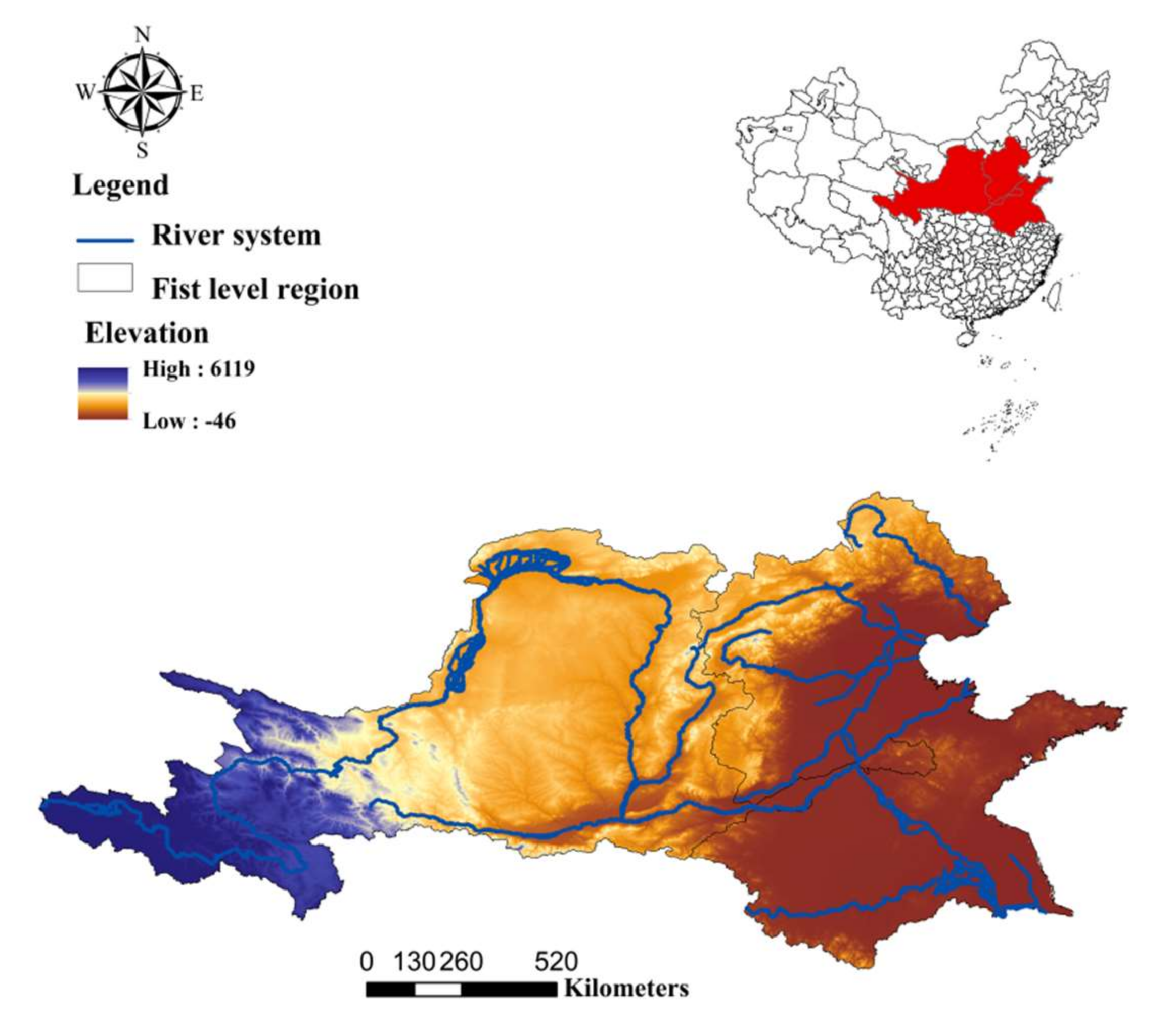
2.1. Study Area
2.2. Data
2.3. Methods
2.3.1. The Evaluation of WLN in the Huang-Huai-Hai River Basin
2.3.2. Land Use Data Analysis Method
2.3.3. Trend Analysis Method
2.3.4. Correlation and Regression Analysis
3. Results
3.1. The Variation Characteristics of Water Resources in the Huang-Huai-Hai River Basin
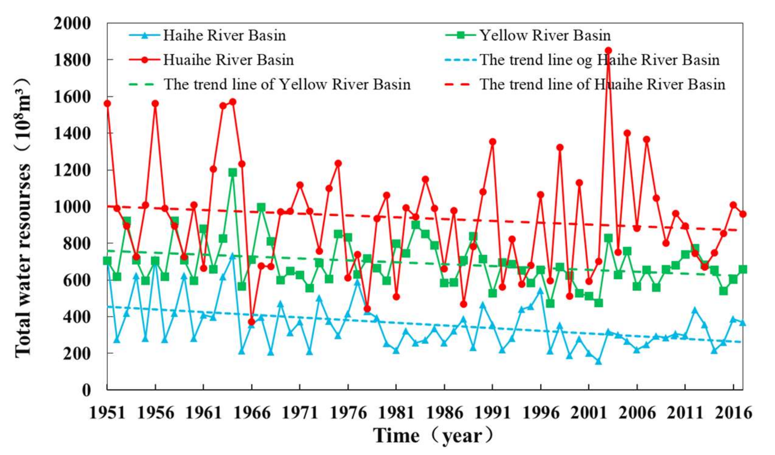
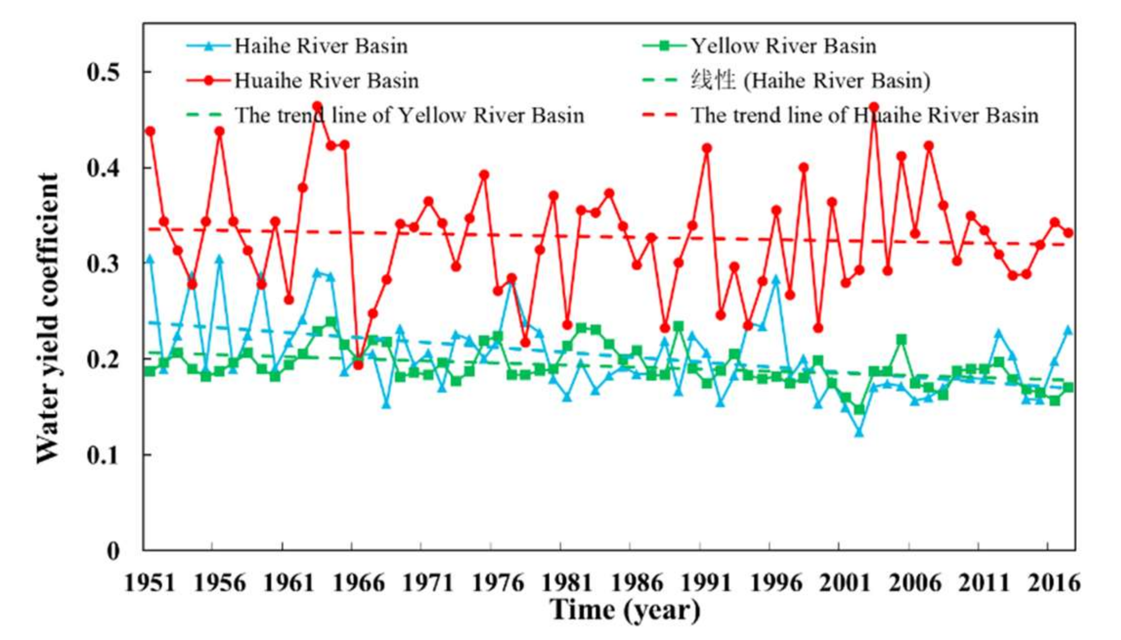
3.1.1. The Temporal Changes in Water Resources in the Huang-Huai-Hai River Basin
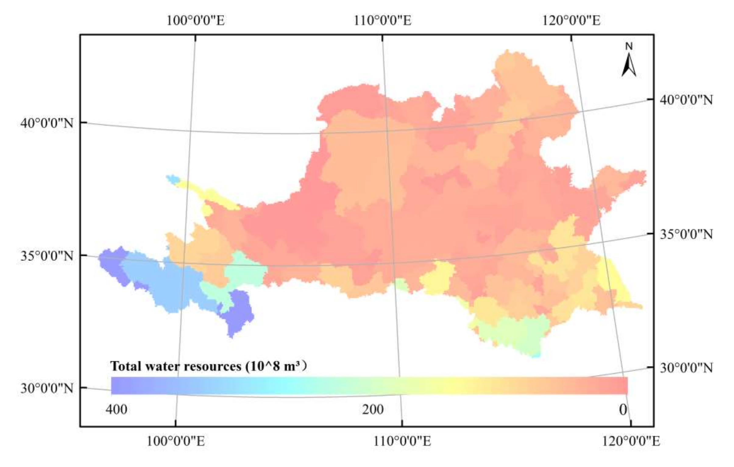
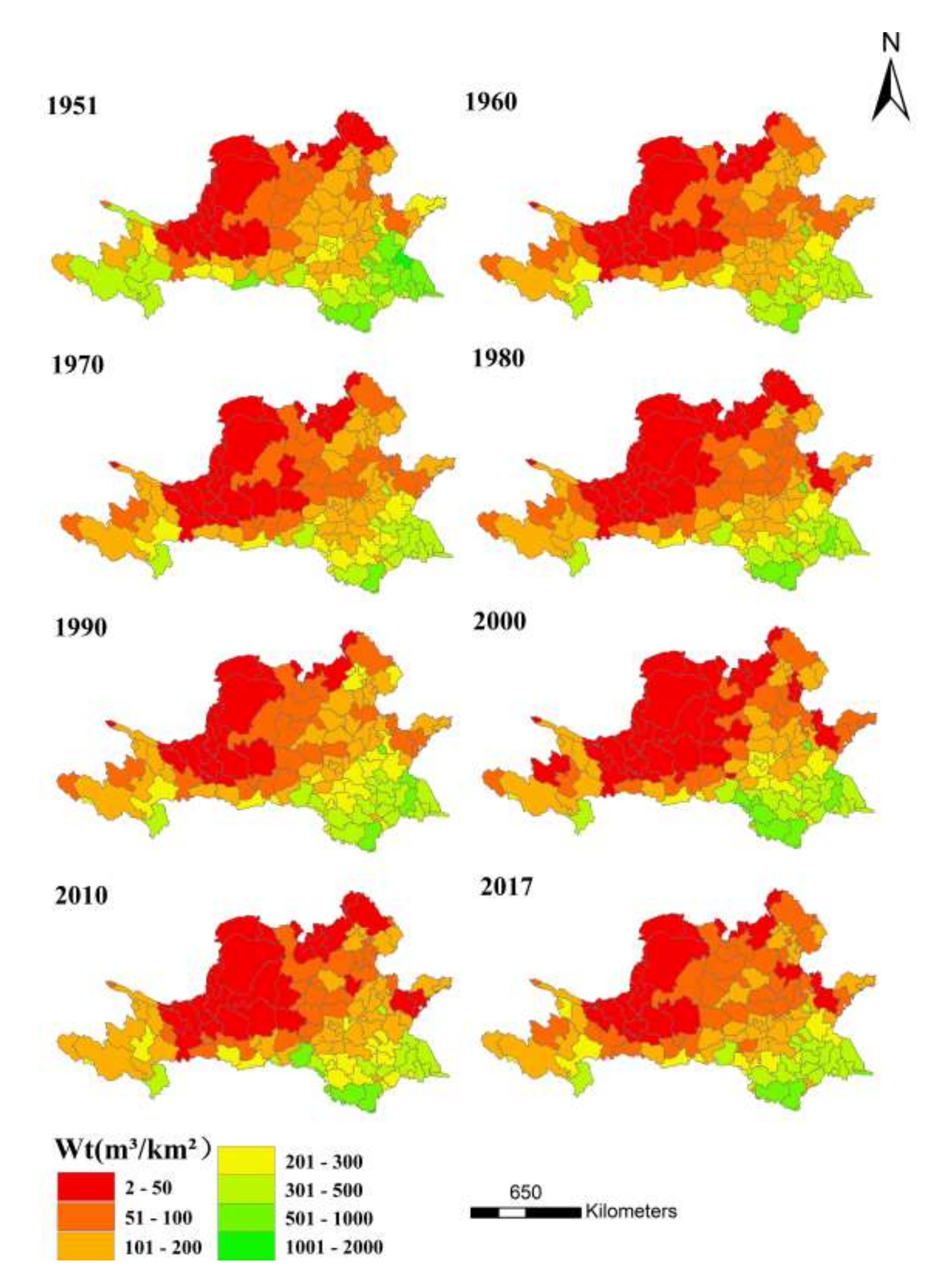
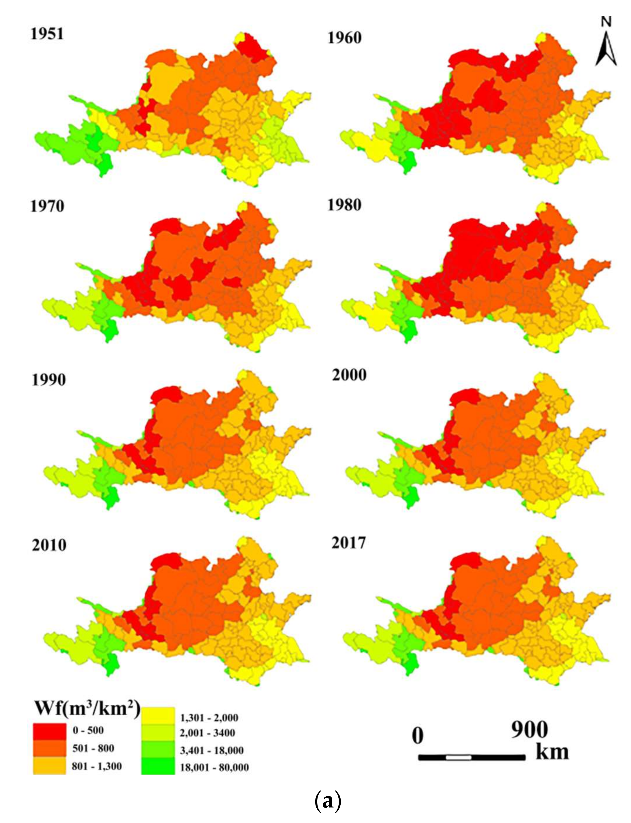
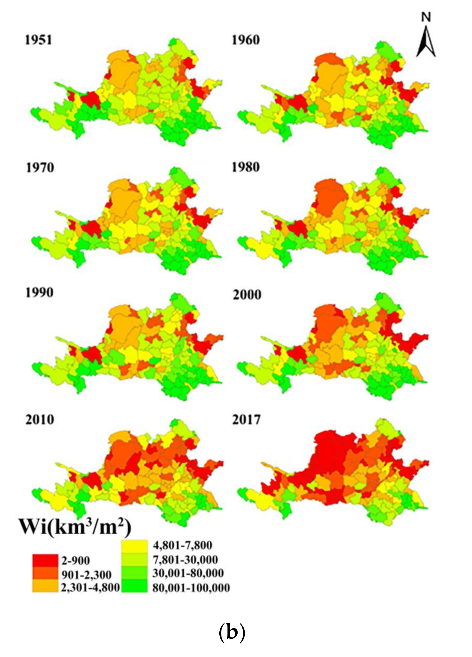
3.1.2. The Spatial Characteristics of Water Resources in the Huang-Huai-Hai River Basin
3.2. The Variation Characteristics of Land Use in the Huang-Huai-Hai River Basin
3.2.1. The Temporal Changes in Land Use in the Huang-Huai-Hai River Basin
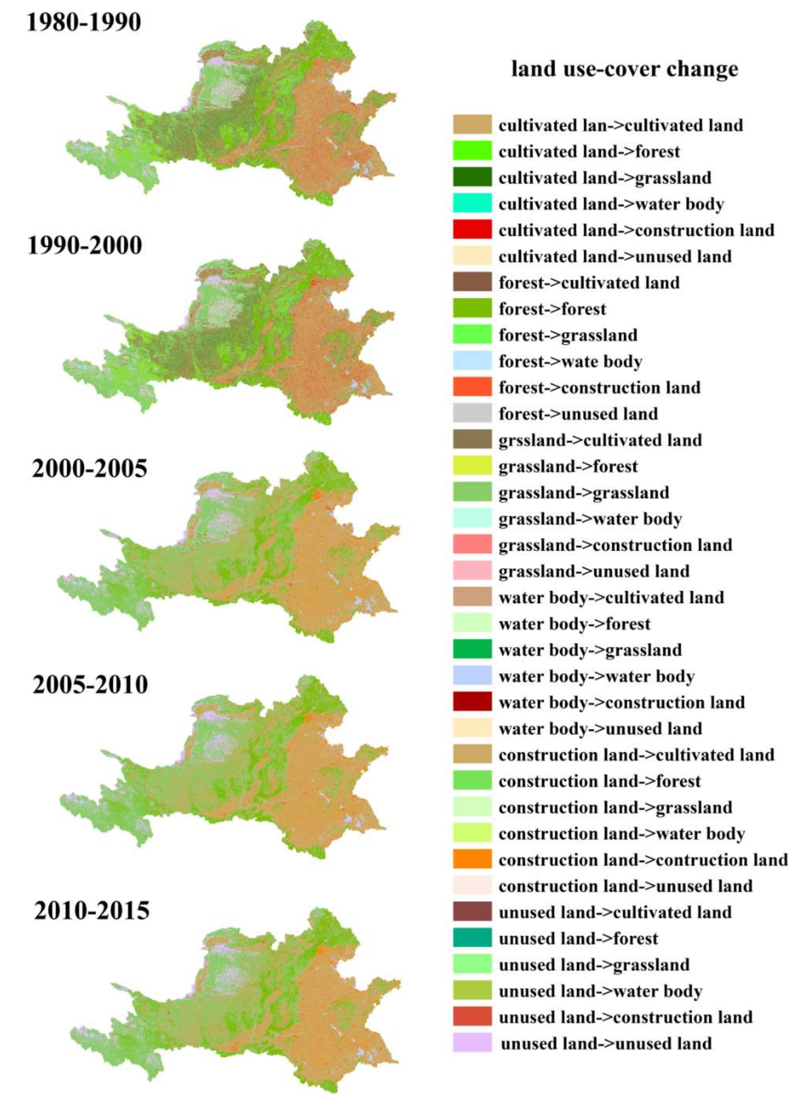
3.2.2. The Spatial Characteristics of Land Use in Huang-Huai-Hai River Basin
3.3. The Spatiotemporal Dynamic Changes in WLN Matching Patterns in the Huang-Huai-Hai River Basin
3.3.1. The Dynamic Spatiotemporal Changes in the Total WLN Matching Index among Provinces and Cities in the Huang-Huai-Hai River Basin
3.3.2. The Spatiotemporal Dynamic Changes in the Different Sectors’ WLN Matching Indexes for the Provinces and Cities in the Huang-Huai-Hai River Basin
3.4. The Dynamic Driving Factors of the Changes in WLN Matching Patterns in the Huang-Huai-Hai River Basin
4. Discussion
4.1. Advantages
4.2. Limitations
4.3. Rationality
5. Conclusions
- (1)
- The total water resources in the Huang-Huang-Hai Basin are decreasing. Among the three first-level regions in the Basin, the Haihe River region decreased the most obviously. The total water resources of the southern cities in the basin are more than those of the northern cities.
- (2)
- The areas of urban land, other construction land, rural residential land, and forest in the Huang-Huai-Hai River Basin increased from 1980 to 2015. Among them, the area of urban land increased the most. However, the areas of paddy fields, dry land, grassland, unused land, and water bodies decreased.
- (3)
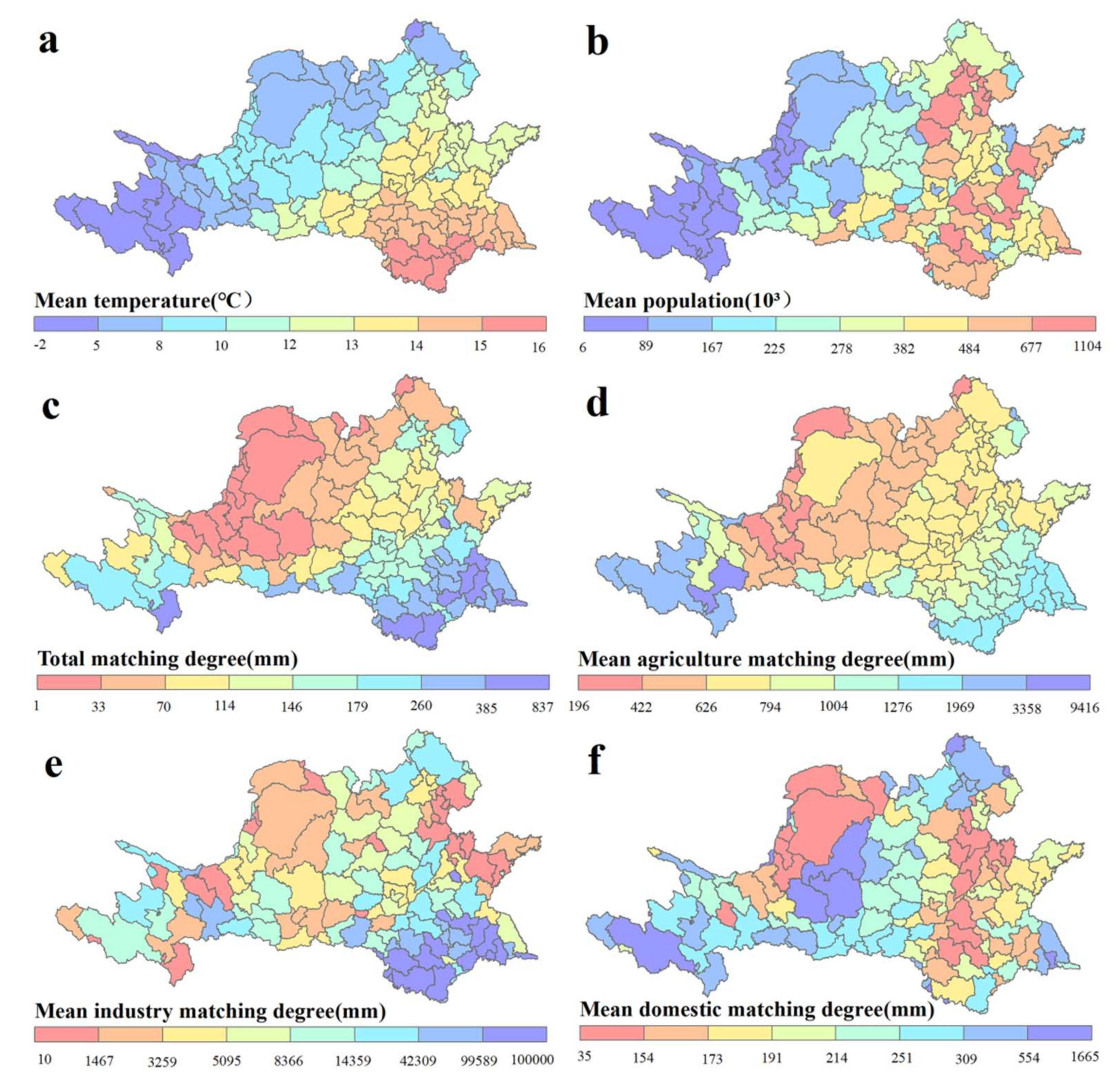
- The total matching index of the water–land nexus gradually increases from the northwest to the southeast in the basin. The agricultural WLN matching index is higher in the south than in the north. The areas where the agricultural matching indexes were too low decreased constantly from 1951 to 2017. Literally, the industrial WLN matching indexes are higher in the east and south than in the west and north. There are generally two living water-deficient zones in the Huang-Huai-Hai River Basin, and the areas with relatively high domestic WLN matching indexes across the whole basin are gradually increasing.
Author Contributions
Funding
Conflicts of Interest
References
- Pan, Y.; Si, X.W.; Jin, M.; Yang, L. Optimal allocation of water and land resource system coupling in the process of urbanization. Bull. Soil Water Conserv. 2010, 30, 216–220. [Google Scholar]
- Yang, Y.Z.; Zhang, W.K.; Feng, Z.M.; Yang, G.G.; Yang, L. Water balance in red soil hilly regions of Southern China under drought climate situations Transactions of the Chinese Society of. Agric. Eng. 2013, 29, 110–119. [Google Scholar]
- Huang, X.; Fang, H.; Wu, M.Y.; Cao, X.C. Assessment of the regional agricultural water-land nexus in China: A green-blue water perspective. Sci. Total Environ. 2022, 804, 150–192. [Google Scholar] [CrossRef] [PubMed]
- Li, M.; Fu, Q.; Singh, V.P.; Liu, D.; Li, T.X.; Li, J. Sustainable management of land, water, and fertilizer for rice production considering footprint family assessment in a random environment. J. Clean. Prod. 2020, 258, 120785. [Google Scholar] [CrossRef]
- Gang, W.; Yan, D.; He, X.; Liu, S.; Zhang, C.; Xing, Z.; Kan, G.; Qin, T.; Ren, M.; Li, H. Trends in extreme temperature indices in Huang-Huai-Hai River Basin of China during 1961–2014.Theor. Appl. Climatol. 2018, 134, 51–65. [Google Scholar]
- Shi, X.; Qin, T.; Yan, D.; Sun, R.; Cao, S.; Jing, L.; Wang, Y.; Gong, B. Analysis of the Changes in the Water Yield Coefficient over the Past 50 Years in the Huang-Huai-Hai River Basin, China. Adv. Meteorol. 2018, 2018, 6302853. [Google Scholar] [CrossRef]
- Bates, B.; Kundzewicz, Z.W.; Wu, S.; Palutikof, J.P. Climate Change and Water; Intergovernmental Panel on Climate Change: Geneva, Switzerland, 2008. [Google Scholar]
- Wang, J.W.; Wang, K.; Qin, T.L.; Nie, H.J.; Lv, Z.Y.; Liu, F.; Shi, X.; Hu, Y. Analysis and prediction of LUCC change in Huang-Huai-Hai River Basin. Open Geosci. 2020, 12, 1406–1420. [Google Scholar] [CrossRef]
- Wang, Y.; Liu, X.; Shi, L.; Shangguan, Z.; Wu, P.; Shan, L.; Zhao, X. Sustainable development of water resources and food security in Northwest China. Strateg. Study Chin. Acad. Eng. 2019, 21, 38–44. [Google Scholar]
- Yira, Y.; Diekkrüger, B.; Steup, G.; Bossa, A.Y. Modeling land use change impacts on water resources in a tropical West African catchment (Dano, Burkina Faso). J. Hydrol. 2016, 537, 187–199. [Google Scholar] [CrossRef]
- Fang, D.l.; Cai, Q.N.; Wu, F.; Chen, B.; Zhang, L.W. Modified linkage analysis for water-land nexus driven by interregional trade. J. Clean. Prod. 2022, 353, 131547. [Google Scholar] [CrossRef]
- Li, P.; Ren, L. Evaluating the effects of limited irrigation on crop water productivity and reducing deep groundwater exploitation in the North China plain using an agro-hydrological model: I. parameter sensitivity analysis, calibration and model validation. J. Hydrol. 2019, 574, 497–516. [Google Scholar] [CrossRef]
- Marhaento, H.; Booij, M.J.; Hoekstra, A.Y. Hydrological response to future land-use change and climate change in a tropical catchment. Hydrol. Sci. J.-J. Des Sci. Hydrol. 2017, 63, 1368–1385. [Google Scholar] [CrossRef] [Green Version]
- Tudose, N.C.; Cremades, R.; Broekman, A.; Sanchez-Plaza, A.; Mitter, H.; Marin, M. Mainstreaming the Nexus Approach in Climate Services Will Enable Coherent Local and Regional Climate Policies. Adv. Clim. Chang. Res. 2021, 12, 752–755. [Google Scholar] [CrossRef]
- Cremades, R.; Mitter, H.; Tudose, C.N.; Sanchez-Plaza, A.; Graves, A.; Broekman, A.; Bender, F.; Giupponi, C.; Koundouri, P.; Bahri, M.; et al. Ten principles to integrate the water-energy-land nexus with climate services for co-producing local and regional integrated assessments. Sci. Total Environ. 2019, 693, 133662. [Google Scholar] [CrossRef]
- Cremades, R.; Sanchez-Plaza, A.; Hewitt, R.J.; Mitter, H.; Baggio, J.A.; Olazabal, M.; Broekman, A.; Kropf, B.; Tudose, N.C. Guiding cities under increased droughts: The limits to sustainable urban futures. Ecol. Econ. 2021, 189, 107140. [Google Scholar] [CrossRef]
- Bernadette, K.; Erwin, S.; Hermine, M. Multi-step cognitive mapping of perceived nexus relationships in the Seewinkel region in Austria. Environ. Sci. Policy 2021, 124, 604–615. [Google Scholar]
- Liu, Y.S.; Gan, H.; Zhang, F.G. Analysis of the Matching patterns of land and water resources in Northeast China. Acta Geogr. Sinica 2006, 61, 847–854. [Google Scholar]
- Li, H.; Zhou, W.B.; Zhuang, Y.; Ma, C.; Liu, B.Y. Agricultural water and soil resources matching patterns and carrying capacity in Yan’an City. Trans. Chin. Soc. Agric. Eng. 2016, 32, 156–162. [Google Scholar]
- Liu, D.; Liu, C.; Fu, Q.; Li, M.; Faiz, M.A.; Khan, M.I.; Li, T.X.; Cui, S. Construction and application of a refined index for measuring the regional matching characteristics between water and land resources. Ecol. Indic. 2018, 91, 203–211. [Google Scholar] [CrossRef]
- Yang, G.Y.; Li, S.Y.; Wang, H.; Wang, L. Study on agricultural cultivation development layout based on the matching characteristic of water and land resources in North China Plain. Agr. Water Man. 2022, 259, 107272. [Google Scholar] [CrossRef]
- Zhang, Y.; Yan, Z.X.; Song, J.X.; Wei, A.L.; Sun, H.T.; Cheng, D.D. Analysis for spatial-temporal matching pattern between water and land resources in CentralAsia. Hydro.Res. 2020, 51, 994–1008. [Google Scholar] [CrossRef]
- Huang, K.W.; Yuan, P.; Liu, G. Research on Water and Soil Resources Matching in Sichuan Province Based on DEA. China Rural. Water Hydropower China 2015, 58–61. [Google Scholar]
- Liu, Y.T.; Wang, S.G.; Chen, B. Water–land nexus in food trade based on ecological network analysis. Eco. Indi. 2019, 97, 455–475. [Google Scholar] [CrossRef]
- Zheng, Y.X.; Hong, J.K.; Xiao, C.L.; Li, Z.M. Unfolding the synergy and interaction of water-land-food nexus for sustainable resource management: A super network analysis. Sci. Total Environ. 2021, 784, 147085. [Google Scholar]
- Shi, x.y.; Takanori, M.; Takashi, M.; Chihiro, H.; Ang, H.; Gan, X.Y. Impact of urbanization on the food–water–land–ecosystem nexus: A study of Shenzhen, China. Sci. Total Environ. 2021, 808, 152138. [Google Scholar] [CrossRef]
- Papadopoulou, C.A.; Papadopoulou, M.P.; Laspidou, C.; Munaretto, S.; Brouwer, F. Towards a low-carbon economy: A nexus-oriented policy coherence analysis in Greece. Sustainability 2020, 12, 373. [Google Scholar] [CrossRef] [Green Version]
- Li, X.; Zhang, Q.; Liu, Y.; Song, J.; Wu, F. Modeling social-economic water cycling and the water–land nexus: A framework and an application. Ecol. Model. 2018, 390, 40–50. [Google Scholar] [CrossRef]
- Totan, G.; Harish, G. Possibilistic multiattribute decision making for water resource management proble munder single-valued bipolar neutrosophic environment. Int. J. Intell. Syst. 2021, 1–28. [Google Scholar] [CrossRef]
- Yuan, Z.; Yan, D.H.; Yang, Z.Y.; Yin, J.; Yuan, Y. Temporal and spatial variability of drought in Huang-Huai-Hai River Basin, China. Theor. Appl. Climatol. 2015, 122, 755–769. [Google Scholar] [CrossRef]
- Wang, G.Q.; Zhang, J.Y. Variation of water resources in the Huang-Huai-Hai areas and adaptive strategies to climate change. Quat. Int. 2015, 380, 180–186. [Google Scholar] [CrossRef]
- Chen, B.; Hanb, M.Y.; Peng, K.; Zhou, S.L.; Shao, L.; Wu, X.F.; Wei, W.D.; Liu, S.Y.; Chen, G.Q. Global land-water nexus: Agricultural land and freshwater use embodied in worldwide supply chains. Sci. Total Environ. 2017, 613, 931–943. [Google Scholar] [CrossRef]
- Cui, B.S.; Yang, Z.F. Eco-environmental water requirement for wetlands in Huang-Huai-Hai Area, China. Prog. Nat. Sci. 2002, 12, 841–848. [Google Scholar]
- Tiwari, S.; Jha, S.K.; Sivakumar, B. Reconstruction of daily rainfall data using the concepts of networks: Accounting for spatial connections in neighborhood selection. J. Hydrol. 2019, 579, 124185. [Google Scholar] [CrossRef]
- Taylan, E.D.; Damçayırı, D. Isparta Bölgesi Yağış Değerlerinin IDW ve Kriging Enterpolasyon Yöntemleri ile Tahmini. Tek. Dergi 2016, 27, 7551–7559. [Google Scholar]
- Song, W.; Deng, X.Z. Land-use/land-cover change and ecosystem service provision in China. Sci. Total Environ. 2017, 576, 705–719. [Google Scholar] [CrossRef]
- Liu, J.Y.; Kuang, W.H.; Zhang, Z.X.; Xu, X.L.; Qin, Y.W.; Ning, J.; Zhou, W.; Zhang, S.; Li, R.; Yan, C.; et al. Spatiotemporal characteristics, patterns, and causes of land-use changes in China since the late 1980s. J. Geogr. Sci. 2014, 24, 195–210. [Google Scholar] [CrossRef]
- Sharma, S.; Saha, A.K. Statistical analysis of rainfall trends over Damodar River basin, India. Arab. J. Geosci. 2017, 10, 1–12. [Google Scholar] [CrossRef]
- Seenu, P.Z.; Jayakumar, K.V. Comparative study of innovative trend analysis technique with Mann-Kendall tests for extreme rainfall. Arab. J. Geosci. 2021, 14, 1–15. [Google Scholar]
- Hamed, K.H.; Rao, A.R. A modified Mann-Kendall trend test for autocorrelated data. J. Hydrol. 1998, 204, 182–196. [Google Scholar] [CrossRef]
- Akritas, M.G.; Murphy, S.A.; LaValley, M.P. The theil-sen estimator with doubly censored-data and applications to astronomy. J. Am. Stat. Assoc. 1995, 90, 170–177. [Google Scholar] [CrossRef]
- Zulqarnain, R.M.; Xin, X.L.; Saqlain, M.; Khan, W.A. TOPSIS Method Based on the Correlation Coefficient of Interval-Valued Intuitionistic Fuzzy Soft Sets and Aggregation Operators with Their Application in Decision-Making. J. Math. 2021, 2021, 16. [Google Scholar] [CrossRef]
- Chicco, D.; Warrens, M.J.; Jurman, G. The coefficient of determination R-squared is more informative than SMAPE, MAE, MAPE, MSE and RMSE in regression analysis evaluation. PeerJ Comput. Sci. 2021, 7, e623. [Google Scholar] [CrossRef]
- Rabia, H.; Saima, M.; Shafqat, I.; Sajawal, P. A Study of Time Series Forecasting Enrollments Using Fuzzy Interval Partitioning Method. J. Comput. Cogn. Eng. 2022, 00, 1–7. [Google Scholar]
- Krishnan, B.; Antonio, G.; Shakoor, H.; Liam, S.; Ben, A. Time series regression studies in environmental epidemiology. Int. J. Epidemiol. 2013, 42, 1187–1195. [Google Scholar] [CrossRef]
- Yuan, Y.; Yan, D.H.; Yuan, Z.; Yin, J.; Zhao, Z.N. Spatial Distribution of Precipitation in Huang-Huai-Hai River Basin between 1961 to 2016, China. Int. J. Environ. Res. Public Health 2019, 16, 3404. [Google Scholar] [CrossRef] [Green Version]

| Primary Type | Secondary Type | ||
|---|---|---|---|
| ID | Name | ID | Name |
| 1 | Arable land | 11 | Paddy field |
| 12 | Dry land | ||
| 2 | Woodland | 21 | Forestland |
| 22 | Bush | ||
| 23 | Opening | ||
| 24 | Other woodland | ||
| 3 | The grass | 31 | High coverage grassland |
| 32 | Medium coverage grass | ||
| 33 | Medium coverage grass | ||
| 4 | Waters | 41 | Graff a |
| 42 | Graff b | ||
| 43 | Reservoir pits | ||
| 44 | Permanent glacial snow | ||
| 45 | Tidal flats | ||
| 46 | On beaches | ||
| 5 | Urban and rural, industrial and mining, residential land | 51 | Urban land use |
| 52 | Rural settlements | ||
| 53 | Other construction land | ||
| 6 | Unused land | 61 | Unused land |
| 62 | The gobi | ||
| 63 | Saline-alkali land | ||
| 64 | Marsh | ||
| 65 | Bare land | ||
| 66 | Bare rock | ||
| 67 | Bare rock | ||
| 9 | 99 | Ocean | |
| Land Use Types (km2) | Time (Year) | ||||||
|---|---|---|---|---|---|---|---|
| 1980 | 1990 | 1995 | 2000 | 2005 | 2010 | 2015 | |
| Paddy field | 60,528 | 60,286 | 60,750 | 60,663 | 59,641 | 59,101 | 58,436 |
| Dry land | 543,899 | 544,379 | 530,315 | 541,269 | 535,418 | 532,721 | 529,135 |
| Forest | 188,331 | 187,450 | 196,516 | 187,754 | 189,992 | 190,514 | 190,466 |
| Grassland | 460,117 | 461,001 | 464,860 | 457,224 | 454,787 | 455,091 | 453,728 |
| Water body | 36,868 | 34,399 | 33,478 | 35,042 | 35,671 | 35,796 | 36,140 |
| Urban land | 8165 | 8950 | 12,186 | 12,548 | 15,514 | 17,401 | 19,687 |
| Rural residential land | 62,044 | 62,408 | 63,093 | 65,096 | 65,962 | 66,254 | 67,523 |
| Other construction land | 4370 | 5447 | 6224 | 6402 | 7346 | 8308 | 11,469 |
| Unused land | 74,473 | 73,841 | 71,231 | 72,787 | 74,459 | 73,603 | 72,205 |
Publisher’s Note: MDPI stays neutral with regard to jurisdictional claims in published maps and institutional affiliations. |
© 2022 by the authors. Licensee MDPI, Basel, Switzerland. This article is an open access article distributed under the terms and conditions of the Creative Commons Attribution (CC BY) license (https://creativecommons.org/licenses/by/4.0/).
Share and Cite
Liu, J.; Bao, Z.; Wang, G.; Zhou, X.; Liu, L. The Spatial and Temporal Assessment of the Water–Land Nexus in a Changing Environment: The Huang-Huai-Hai River Basin (China). Water 2022, 14, 1905. https://doi.org/10.3390/w14121905
Liu J, Bao Z, Wang G, Zhou X, Liu L. The Spatial and Temporal Assessment of the Water–Land Nexus in a Changing Environment: The Huang-Huai-Hai River Basin (China). Water. 2022; 14(12):1905. https://doi.org/10.3390/w14121905
Chicago/Turabian StyleLiu, Jing, Zhenxin Bao, Guoqing Wang, Xinlei Zhou, and Li Liu. 2022. "The Spatial and Temporal Assessment of the Water–Land Nexus in a Changing Environment: The Huang-Huai-Hai River Basin (China)" Water 14, no. 12: 1905. https://doi.org/10.3390/w14121905
APA StyleLiu, J., Bao, Z., Wang, G., Zhou, X., & Liu, L. (2022). The Spatial and Temporal Assessment of the Water–Land Nexus in a Changing Environment: The Huang-Huai-Hai River Basin (China). Water, 14(12), 1905. https://doi.org/10.3390/w14121905


