A River Channel Extraction Method Based on a Digital Elevation Model Retrieved from Satellite Imagery
Abstract
:1. Introduction
2. Research Methods and Data Sources
2.1. Study Area
2.2. Research Route and Methods
2.2.1. Research Route
2.2.2. Methods
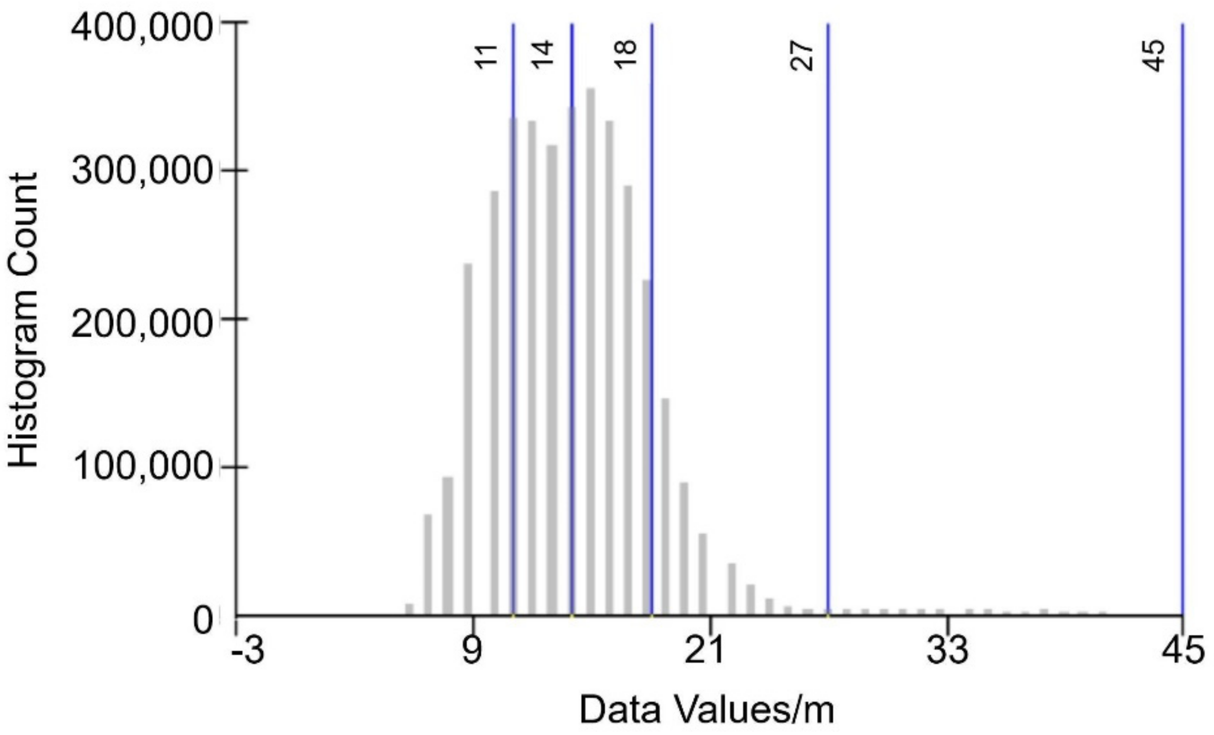
Jenks Natural Breaks Classification (Jenks) Method
NDWI
OTSU
Accuracy Verification Method
2.3. Data Source
3. Results
4. Discussion
5. Conclusions
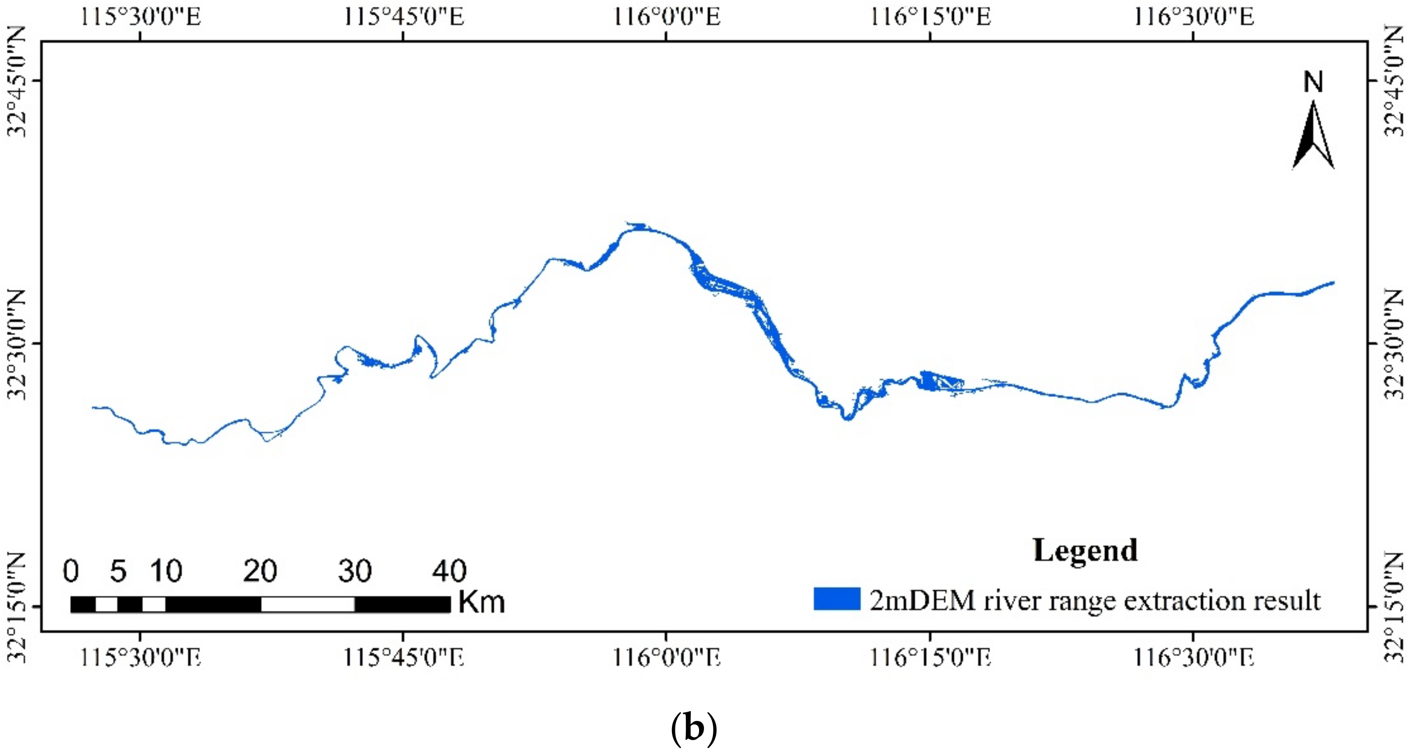
- A new method for remote sensing river range extraction based on DEM and GF-1 data is proposed by merging Jenks natural breaks classification with digital elevation model. The overall accuracy is better than 85%, and the Kappa coefficient (0.41–0.60) is moderately consistent, showing that the procedure is viable and successful;
- The extraction accuracy grows as DEM resolution increases, and the higher the DEM resolution, the better the extraction effect;
- When DEM resolution is lower than GF-1 resolution, GF-1 alone has better effect;
- The new method combining DEM channel extraction with GF-1 is more appropriate for DEM data with a DEM resolution of 5 m or higher.
- The DEM channel extraction method based solely on Jenks natural breaks classification method is better suited for obtaining high-precision DEM channel ranges in small regions.
Author Contributions
Funding
Institutional Review Board Statement
Informed Consent Statement
Data Availability Statement
Acknowledgments
Conflicts of Interest
Abbreviations
| DEM | Digital Elevation Model |
| GF-1 | GF-1 satellite |
References
- Shanxi Lingqiu Black Branch Provincial Nature Reserve Authority. In Natural Ecological Protection Noufangi; Chinese Forestry Publishing House: Beijing, China, 2013.
- Huan, W.U.; Yong-Hong, Y.I.; Wang, X. A River Bank Extracting Algorithm Based on Active Contour Model from High-Resolution Satellite Images. Remote Sens. Technol. Appl. 2006, 21, 407–413. [Google Scholar] [CrossRef]
- Gueneralp, I.; Filippi, A.M.; Hales, B.U. River-Flow Boundary Delineation from Digital Aerial Photography and Ancillary Images Using Support Vector Machines. GISci. Remote Sens. 2013, 50, 1–25. [Google Scholar] [CrossRef]
- Milad, N.J.; Alfonso, V. Reconstruction of River Boundaries at Sub-pixel Resolution: Estimation and Spatial Allocation of Water Fractions. Int. J. Geo Inf. 2017, 6, 383. [Google Scholar] [CrossRef] [Green Version]
- Yao, F.; Wang, C.; Dong, D.; Luo, J.; Shen, Z.; Yang, K. High-Resolution Mapping of Urban Surface Water Using ZY-3 Multi-spectral Imagery. Remote Sens. 2015, 7, 12336–12355. [Google Scholar] [CrossRef] [Green Version]
- Huang, C.; Chen, Y.; Zhang, S.; Wu, J. Detecting, Extracting, and Monitoring Surface Water from Space Using Optical Sensors: A Review. Rev. Geophys. 2018, 56, 333–360. [Google Scholar] [CrossRef]
- Yuan, X.Z.; Jiang, H.; Chen, Y.Z.; Wang, X. Extraction of Water Body Information Using Adaptive Threshold Value and OTSU Algorithm. Remote Sens. Inf. 2016, 31, 36–42. [Google Scholar] [CrossRef]
- Guo, Y.; Wang, Y.H.; Liu, C.P.; Gong, S.R.; Ji, Y. Bankline Extraction in Remote Sensing Images Using Principal Curves. J. Commun. 2016, 37, 80–89. [Google Scholar] [CrossRef]
- He, Z.; Li, C.; Zhang, L.; Jie, S. River Channel Extraction by Combining Grey Threshold Segmentation and Contour Form Recognition. J. Electron. Meas. Instrum. 2014, 28, 1288–1296. [Google Scholar] [CrossRef]
- Ni, L.; Zhishun, W.; Lin, W.; Zhao, J. River-Net: A Novel Neural Network Model for Extracting River Channel Based on Refined-Lee Kernel. J. Radars. 2021, 10, 324–334. [Google Scholar] [CrossRef]
- Zaidi, S.M.; Akbari, A.; Gisen, J.I.; Kazmi, J.H.; Gul, A.; Fhong, N.Z. Utilization of Satellite-Based Digital Elevation Model (DEM) for Hydrologic Applications: A Review. J. Geol. Soc. India 2018, 92, 329–336. [Google Scholar] [CrossRef]
- Barták, V. How to Extract River Networks and Catchment Boundaries from DEM: A Review of Digital Terrain Analysis Techniques. J. Landsc. Stud. 2009, 2, 57–68. [Google Scholar]
- O’Callaghan, J.F.; Mark, D.M. The Extraction of Drainage Networks from Digital Elevation Data. Comput. Vis. Graph. Image Process. 1984, 28, 323–344. [Google Scholar] [CrossRef]
- Lun, W.U.; Wang, D.M.; Zhang, Y. Research on the Algorithms of the FLow Direction Determination in Ditches Extraction Based on Grid DEM. J. Image Graph. 2006, 11, 998–1003. [Google Scholar] [CrossRef]
- Yang, H.; Cao, J. Analysis of Basin Morphologic Characteristics and Their Influence on the Water Yield of Mountain Watersheds Upstream of the Xiongan New Area, North China. Water 2021, 13, 2903. [Google Scholar] [CrossRef]
- Wu, J.; Guo, K.; Wang, M.; Xu, B. Research and Extraction of the Hydrological Characteristics Based on GIS and DEM; IEEE Publications: New York, NY, USA, 2011. [Google Scholar] [CrossRef]
- Colombo, R.; Vogt, J.V.; Soille, P.; Paracchini, M.L.; de Jager, A. Deriving River Networks and Catchments at the European Scale from Medium Resolution Digital Elevation Data. Catena 2007, 70, 296–305. [Google Scholar] [CrossRef]
- Dong, P.; Zhong, R.; Xia, J.; Tan, S. A Semiautomated Method for Extracting Channels and Channel Profiles from Lidar-Derived Digital Elevation Models. Geosphere 2020, 16, 806–816. [Google Scholar] [CrossRef] [Green Version]
- Muthusamy, M.; Casado, M.R.; Butler, D.; Leinster, P. Understanding the Effects of Digital Elevation Model Resolution in Urban Fluvial Flood Modelling. J. Hydrol. 2021, 596, 126088. [Google Scholar] [CrossRef]
- Coulson, M.R.C. In the Matter of Class Intervals for Choropleth Maps: With Particular Reference to the Work of George F Jenks. Cartogr. Int. J. Geogr. Inf. Geovis. 1987, 24, 16–39. [Google Scholar] [CrossRef]
- Jenks, G.F. Generalization in Statistical Mapping. Ann. Assoc. Am. Geogr. 1963, 53, 15–26. [Google Scholar] [CrossRef]
- Chen, J.; Yang, S.T.; Li, H.W.; Zhang, B.; Lv, J.R. Research on Geographical Environment Unit Division Based on the Method of Natural Breaks (Jenks). Int. Arch. Photogramm. Remote Sens. Spatial Inf. Sci. 2013, XL-4/W3, 47–50. [Google Scholar] [CrossRef] [Green Version]
- McFeeters, S.K. The Use of the Normalized Difference Water Index (NDWI) in the Delineation of Open Water Features. Int. J. Remote Sens. 1996, 17, 1425–1432. [Google Scholar] [CrossRef]
- Otsu, N. A Threshold Selection Method from Gray-Level Histograms. IEEE Trans. Syst. Man Cybern. 1979, 9, 62–66. [Google Scholar] [CrossRef] [Green Version]
- Hollingsworth, D.; The Workflow Reference Model, Workflow Management Coalition (WFMC). Document No. TC00-1003, No. 1.1. 1995. Available online: www.pa.icar.cnr.it/cossentino/ICT/doc/D12.1%20-%20Workflow%20Management%20Coalition%20-%20The%20Workflow%20Reference%20Model.pdf (accessed on 17 March 2022).
- Ji, L.; Zhang, L.; Wylie, B. Analysis of Dynamic Thresholds for the Normalized Difference Water Index. Photogramm. Eng. Remote Sens. 2009, 75, 1307–1317. [Google Scholar] [CrossRef]
- Goh, T.Y.; Basah, S.N.; Yazid, H.; Aziz Safar, M.J.; Ahmad Saad, F.S. Performance Analysis of Image Thresholding: Otsu Technique. Measurement 2018, 114, 298–307. [Google Scholar] [CrossRef]
- Sahoo, P.K.; Soltani, S.; Wong, A.K.C. A Survey of Thresholding Techniques. Comput. Vis. Graph. Image Process. 1988, 41, 233–260. [Google Scholar] [CrossRef]






| Data | Resolution | Data Source |
|---|---|---|
| DEM | 30 m (2020) | Geospatial Data Cloud (https://www.gscloud.cn/, (accessed on 17 March 2022)) |
| 12.5 m (2021) | Geospatial Data Cloud | |
| 5 m (2021) | China Centre for Resources Satellite Data and Application | |
| 2 m (April 2021) | Laser point cloud data extraction results | |
| GF-1 (30 May 2021) | 16 m | China Centre for Resources Satellite Data and Application |
| River section data | / | ADCP measurement results |
| Data | Real Value | Channel Area (km2) | Non-Channel Area (km2) | OA | Kappa | |
|---|---|---|---|---|---|---|
| Predictive Value | ||||||
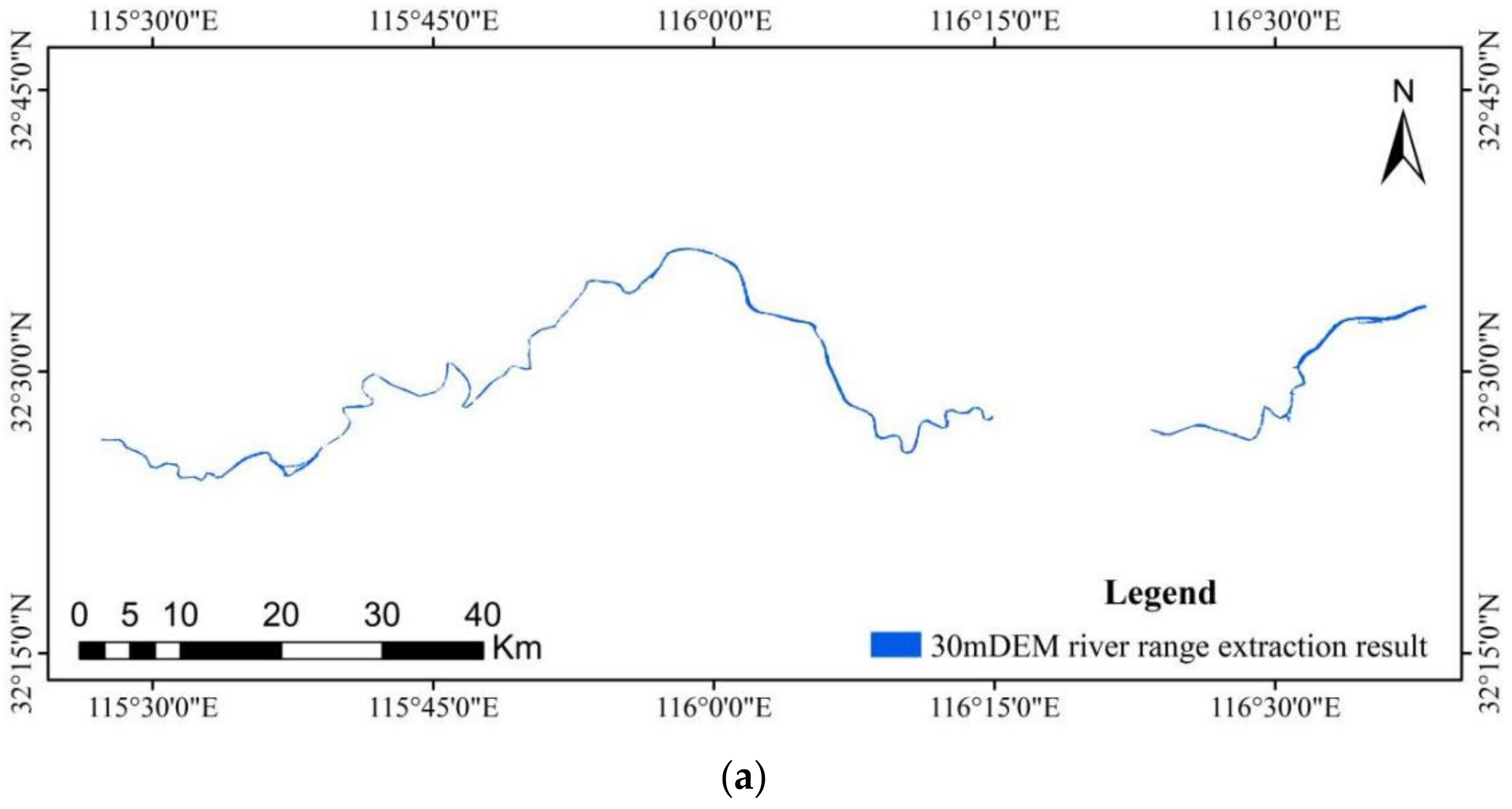
| 30 m DEM | Channel area (km2) | 28.25 | 1.69 | 89.3% | 0.44 | |
| Non-channel area (km2) | 59.22 | 482.14 | ||||
| 12.5 m DEM | Channel area (km2) | 29.17 | 1.32 | 89.6% | 0.45 | |
| Non-channel area (km2) | 58.29 | 482.51 | ||||
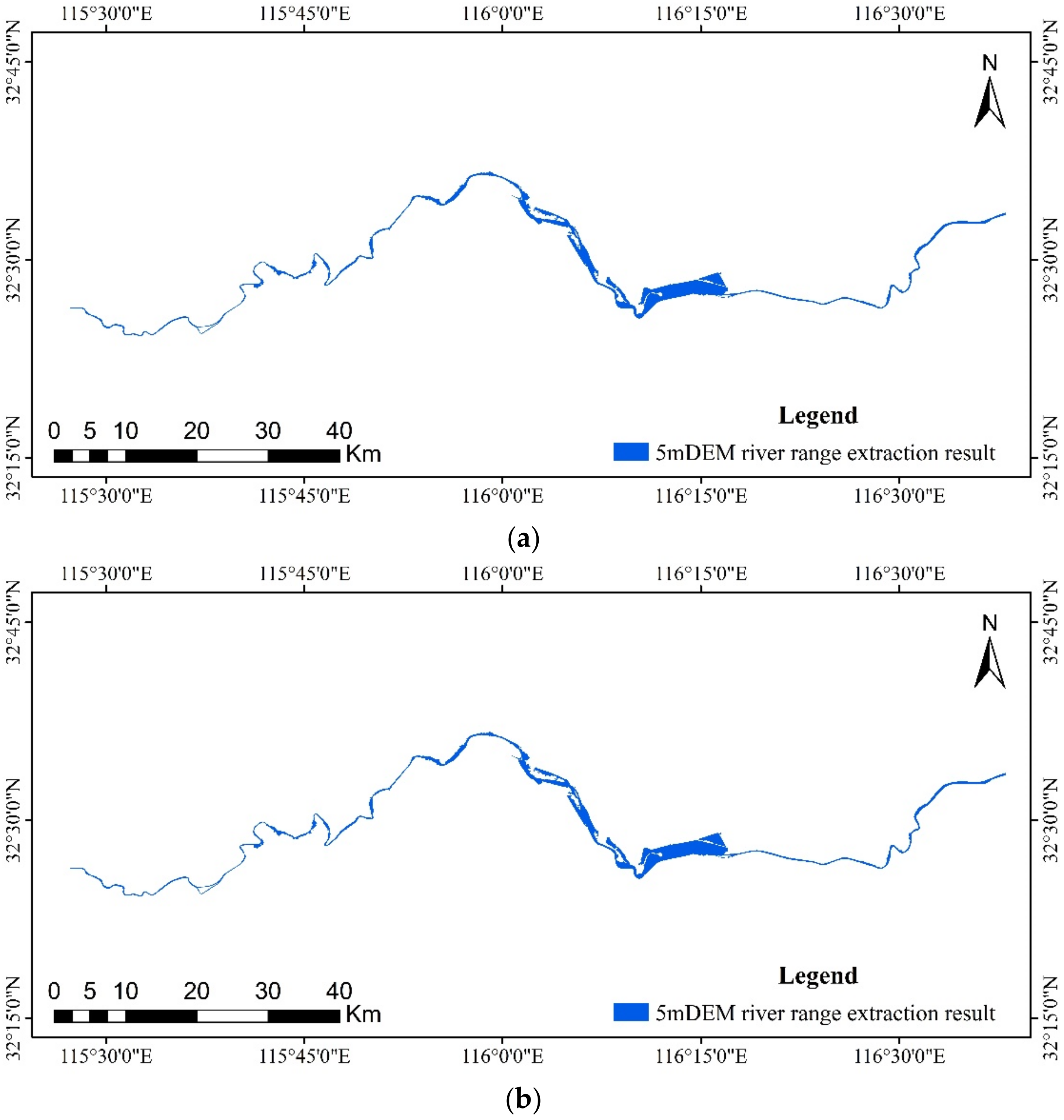
| 5 m DEM | Channel area (km2) | 49.59 | 23.00 | 89.3% | 0.56 | |
| Non-channel area (km2) | 37.87 | 460.82 | ||||
| 2 m DEM | Channel area (km2) | 49.36 | 17.42 | 90.3% | 0.59 | |
| Non-channel area (km2) | 38.11 | 466.41 | ||||
| GF-1 | Channel area (km2) | 39.38 | 12.25 | 89.4% | 0.51 | |
| Non-channel area (km2) | 48.09 | 471.58 | ||||
| Data | Real Value | Channel Area (km2) | Non-Channel Area (km2) | OA | Kappa | |
|---|---|---|---|---|---|---|
| Predictive Value | ||||||
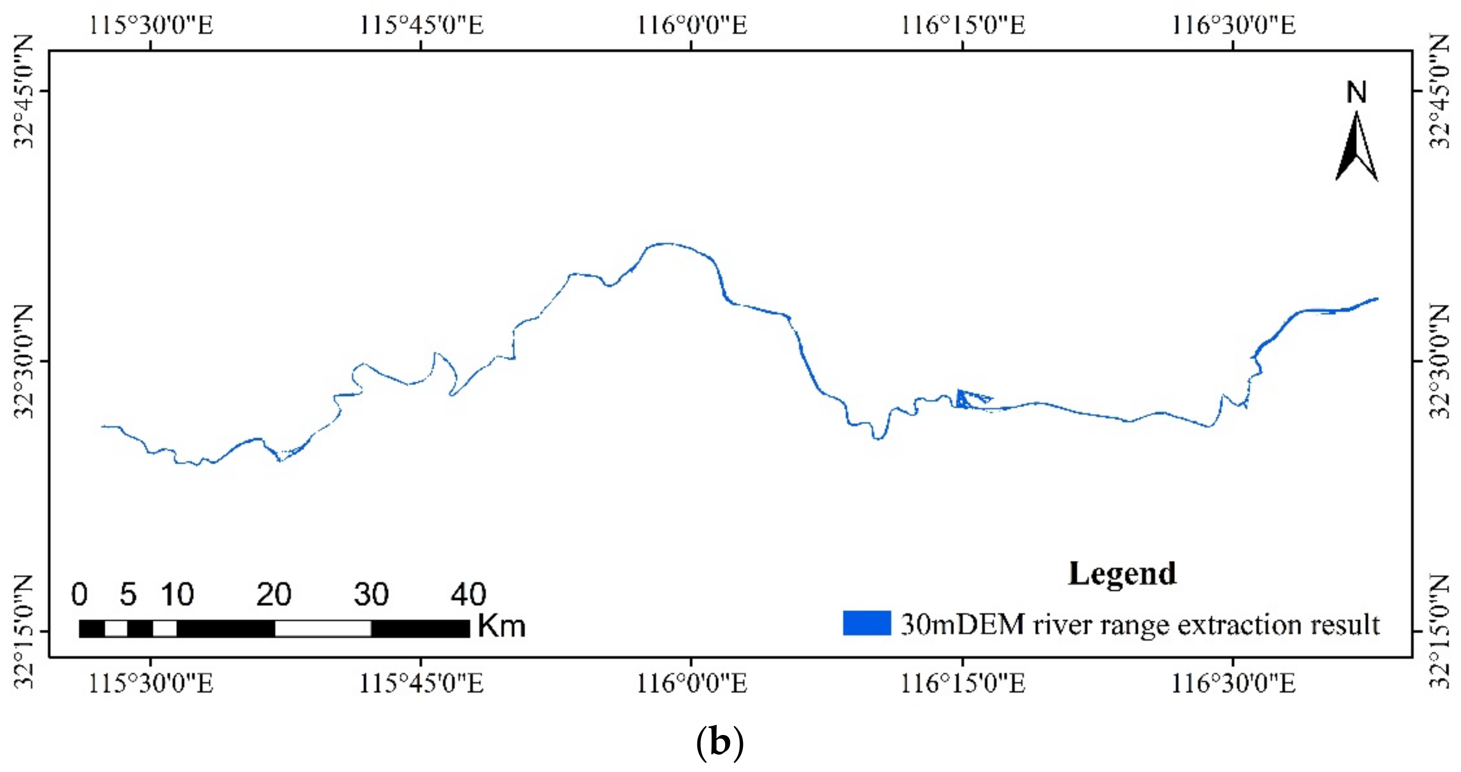
| 30 m DEM | Channel area (km2) | 31.43 | 3.61 | 89.6% | 0.47 | |
| Non-channel area (km2) | 56.05 | 480.22 | ||||
| 12.5 m DEM | Channel area (km2) | 32.12 | 3.26 | 89.7% | 0.48 | |
| Non-channel area (km2) | 55.36 | 480.57 | ||||
| 5 m DEM | Channel area (km2) | 49.59 | 23.01 | 89.3% | 0.56 | |
| Non-channel area (km2) | 37.87 | 460.82 | ||||
| 2 m DEM | Channel area (km2) | 49.48 | 17.42 | 90.3% | 0.59 | |
| Non-channel area (km2) | 37.99 | 466.41 | ||||
Publisher’s Note: MDPI stays neutral with regard to jurisdictional claims in published maps and institutional affiliations. |
© 2022 by the authors. Licensee MDPI, Basel, Switzerland. This article is an open access article distributed under the terms and conditions of the Creative Commons Attribution (CC BY) license (https://creativecommons.org/licenses/by/4.0/).
Share and Cite
Gui, R.; Song, W.; Pu, X.; Lu, Y.; Liu, C.; Chen, L. A River Channel Extraction Method Based on a Digital Elevation Model Retrieved from Satellite Imagery. Water 2022, 14, 2387. https://doi.org/10.3390/w14152387
Gui R, Song W, Pu X, Lu Y, Liu C, Chen L. A River Channel Extraction Method Based on a Digital Elevation Model Retrieved from Satellite Imagery. Water. 2022; 14(15):2387. https://doi.org/10.3390/w14152387
Chicago/Turabian StyleGui, Rongjie, Wenlong Song, Xiao Pu, Yizhu Lu, Changjun Liu, and Long Chen. 2022. "A River Channel Extraction Method Based on a Digital Elevation Model Retrieved from Satellite Imagery" Water 14, no. 15: 2387. https://doi.org/10.3390/w14152387
APA StyleGui, R., Song, W., Pu, X., Lu, Y., Liu, C., & Chen, L. (2022). A River Channel Extraction Method Based on a Digital Elevation Model Retrieved from Satellite Imagery. Water, 14(15), 2387. https://doi.org/10.3390/w14152387


