Abstract
The topography of the Puyang River catchment is complex and includes hills and plains. The Zhuji basin in the middle reaches a densely populated area facing serious flooding issues, due to the upstream flooding and downstream backwater. To address the problem, this study applies the Xin’anjiang hydrological model and IFMS 1D-2D hydrodynamic model, to simulate flood scenarios. The simulation results demonstrated that the hydrological model and the -hydrodynamic model together are a feasible tool to monitor the flooding process in the Puyang River catchment. In addition, different flood scenarios which consider disaster-inducing factors and flood control operations are simulated by the model. Reasonable solutions are analyzed for the local flood management.
1. Introduction
The Puyang River catchment is located in the southern region of the Qiantang River delta. Due to its geographical location and climate conditions, the catchment has suffered several floods throughout history. Flood events have become more frequent in recent years, due to the ongoing urbanization and climate change, leading to significant socio-economic consequences [1,2,3,4,5,6,7,8]. To reduce flood losses, there is an urgent need for the Puyang River catchment to explore flood simulation methods. These methods are expected to be able to simulate and analyze different scenarios, which can guide the flood control management in the future. However, the topography of the Puyang River catchment has a feature of high ends with a low basin in the middle. The river streams are affected by the inflows from the upstream mountains and high tides from downstream. This causes problems when applying the Xin’anjiang model [9], as the downstream tidal effects on the flood duration cannot be considered in the Muskingum channel confluence routing of the model. Meanwhile, due to uncertainty factors, such as climate change and urban development, a hydrodynamic model alone is not capable to simulate the impact of the rainfall variations on the fluvial floods in the catchment [10,11,12].
The hydrological-hydrodynamic model has emerged to fix the simulation gap that a single model cannot complete [13,14,15,16,17,18]. This article applies the hydrological model and the hydrodynamic model by a simple connection—the output of the hydrological model is served as the input for the hydrodynamic model, the results of which will have no impact on the first model. Currently, this method is commonly used between the hydrological and hydrodynamic models, i.e., the hydraulic linkage between the upstream and downstream is realized by inputting the output of the hydrological model into the hydrodynamic model [19,20]. The simulation of the inundation process of the fluvial floods is achieved by the internal coupling of the 1D and 2D hydrodynamic models.
Flood simulation with the above linked hydrological-hydrodynamic models has been studied by several scholars. Han et al. [21] linked the SCS hydrological model to the MIKE 11 hydrodynamic model and applied it to assess the impact of the regional precipitation on the flooding process of the river network in the Jiaxing area. In the Tai Lake catchment, Liu et al. [22] developed the linked VIC hydrological-ISIS hydrodynamic model to analyze the flood risks under different scenarios in mountainous and plain areas. While Dong et al. [23] and Luo et al. [24] studied the effect of the land use change on the drainage modulus in plain areas by linking the hydrological and hydrodynamic models. However, most applications do not further consider the coupling of the 1D and 2D hydrodynamic models, which can realize the whole process simulation and enable the analysis of the inundation scenarios. Therefore, such coupled models can improve the accuracy and operational capability of the flood hazard assessment [25,26].
Based on previous research, this paper aims to link the Xin’anjiang hydrological model and the IFMS 1D2D hydrodynamic model [27] for the upstream mountains and downstream basins in the Puyang River catchment. The inability of the Xin’anjiang model (i.e., the Muskingum channel confluence routing) and the hydrodynamic model (i.e., difficulty of responding to rainfall changes) are improved. The hydrological-hydrodynamic model is applied to the flood scenario simulations to analyze flood inundation under extreme rainfall events and anthropogenic activities, which is expected to promote an integrated flood and emergency response management of the Puyang River catchment.
2. Study Area
The Puyang River catchment is located in the southern region of the Yangtze River delta, with a total area of 3451.5km2. The climate of the Puyang catchment is dominated by subtropical monsoons, showing a feature of distinct seasons with abundant rainfall. During summer and autumn, frequent tropical storms and typhoons are the main cause of floods in the catchment.
The terrain of the Puyang River catchment is complex, including hills, basins and plains. The basin in the midstream is a densely inhabited area. Due to the topography, flood risks in the midstream are high during heavy rains. There are many lakes and cultivated fields in the low-lying areas along the river. These areas are identified as key protection zones for flood control by the government of Zhuji City [28], of which the safety is mainly dependent on the existing embankments along the river. The special geographical location and the developed socio-economic development require an integrated flood control management. In the Puyang River catchment, engineering projects have been constructed, including reservoirs, flood detention areas and pump stations. These infrastructures help to store, divert and discharge water during floods, which improves the drainage capacity of the lake and farming areas.
3. Methods
3.1. Hydrological-Hydrodynamic Model
This paper develops a three-layer Xin’anjiang model to simulate the runoff process in the upstream mountainous areas. For the downstream area, an IFMS 1D and 2D hydrodynamic coupling model is developed to simulate floods and overland flows. The outcomes of the Xin’anjiang model are used as inputs for the 1D and 2D hydrodynamic models. As the historical flood disasters in the Puyang River catchment are always with dyke breaches or overtopping, the flow exchange between the 1D and 2D is therefore via the dyke breaches or overtopping. The relationship between hydrological model and hydrodynamic model is presented in Figure 1.

Figure 1.
Hydrological-hydrodynamic model.
3.2. Xin’anjiang Model in the Upstream Mountainous Area
The Xin’anjiang model was proposed by Zhao et al. (1992) [9] in the 1980s, with its core on the storage capacity curve in the catchment. The model has a 4-layer structure, including evapotranspiration, runoff production, separation of the runoff components and flow concentration. The Xin’anjiang model is applicable for humid regions, hence, it is applied in the upstream mountainous area of the catchment. The whole catchment is divided into eight sub-catchments, based on the topography, flow directions and river networks, see Figure 2 for the location of each sub-catchment, and the detailed information of each sub-catchment is presented in Table 1.
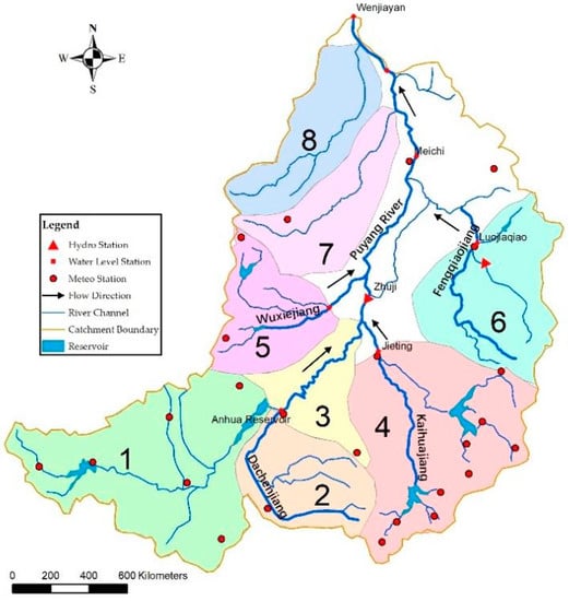
Figure 2.
Hydrological division of the Puyang River catchment. (The division range of each sub-catchment in Figure 2: (1) the catchment of the Anhua Reservoir; (2) upstream catchment of the Longtan section of Dachenjiang River; (3) catchment between the Anhua Reservoir and Yajiayang; (4) upstream catchment of the Jieting water level station in Kaihuajiang River; (5) upstream catchment of the Shuimotou section of Wuxiejiang River; (6) upstream catchment of the Luojiaqiao section of Fengqiaojiang River; (7) the Huangtongjiang river catchment; (8) the Yongxing river catchment.).

Table 1.
Hydrological division of the Puyang River catchment.
Due to the inconsistency of the collected data, the hydrological model and the hydrodynamic model are calibrated separately. In the Puyang River catchment, the long-time series flow observation data can only be collected at the Anhua Reservoir and the Zhuji hydrological station. Hence, for the two sub-catchments where the Anhua Reservoir and Zhuji hydrological station are located, a Xin’anjiang model is set up and the model parameters are calibrated. The hydrological parameters of the Anhua Reservoir are applied to the Dachenjiang River catchment, while the sub-catchments of Kaihuajiang River, Wuxiejiang River and Fengqiaojiang River adopt the hydrological parameters of the Zhuji hydrological station. To take local lateral inflows into account, the flooding process in the sub-catchment of the Zhuji hydrological station is transposed to other sub-catchments, based on the area ratios. The flood information and data between 1989 and 2014 are used for the calibration and validation of the Anhua Reservoir, in which, the 12 flood events that occurred between 1989 and 1999, are used for the calibration, and five flood events that occurred in the period between 2007 and 2014 are validated. For the Zhuji hydrological station, the data between 1987 and 2017 are applied, in which, the 17 flood events that occurred in the period between 1987 and 1999 are calibrated and the seven events that occurred between 2007 and 2017 are validated. The initial values of the simulation are set according to the prior information, and are finalized by the dynamic parameter optimization.
The calibration results are presented in Table 2 and Table 3. The parameters are [9] K: the ratio of the potential evapotranspiration to pan evaporation; WM: the areal mean tension water capacity; WUM/WLM: the upper/lower layer of the WM; C: the coefficient of deep evapotranspiration; B: the parameter in the distribution of the tension water capacity; SM: the areal mean free water storage capacity; EX: the parameter in the distribution of the free water storage capacity; KI/KG: the coefficients contributing to the interflow/groundwater storage; CS: the route parameter of the flow concentration within the sub-basin; CI/CG: the recession constants of the lower interflow/groundwater storage; and KE/XE: the parameters of the Muskingum method.

Table 2.
Parameters of the Xin’anjiang model in the Anhua Reservoir catchment.

Table 3.
Parameters of the Xin’anjiang model in the Zhuji catchment.
3.3. 1D Unsteady Flow Model
The model simulation of the channel flows uses the Saint-Venant equations, which can be written as follows.
In which, A is the cross-section area, m2; t is the time, s; Q is the discharge, m3 s−1; x is the distance, m; q is the lateral inflow per unit length, m3 s−1/m; η is the water level, m; g is the gravitational acceleration, m s−2; and Sf is the slope friction, s2 m−3.
The hydrodynamic modelling area is the main Puyang River, starting from the Anhua Reservoir to the Puyang River estuary, see Figure 3. The upstream model boundaries for the tributaries are Longtan at Dachengjiang River, the Jieting hydrological station at Kaihuajiang River, Shuimotou at Wuxiejiang River, and Luojiaqiao at Fengqiaojiang River.
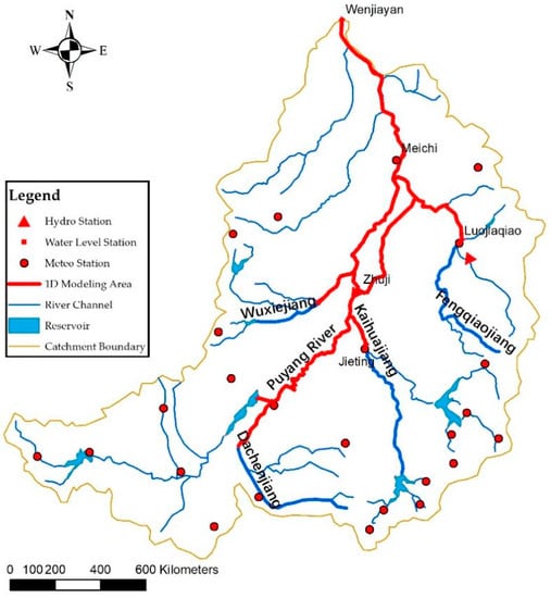
Figure 3.
1D hydrodynamic modeling area.
The numerical simulation of the 1D hydrodynamic model has high requirements on the parameters of the river cross-sections, while it is also greatly affected by the shape of the cross-sections. Hence, six historical flood events in the past two decades are selected for the parameter calibration and validation. Five of the six flood events are used for the calibration, which occurred in 1997, 2007, 2012, 2013 and 2014, while the validation uses the No. 20110613 flood. The inflow boundary of the 1D hydrodynamic model is the simulation results of the Xin’anjiang model in the upstream mountains, in which the flood of the Anhua Reservoir needs to be inputted after the flood regulating calculation. The outflow boundary is the observed water level at Wenjiayan. The results of the roughness calibration of the river reaches are presented in Table 4.

Table 4.
Hydraulic roughness coefficient of Puyang River.
3.4. 2D Overland Model
The overland flow movements are described by the 2D shallow water equations with an average water depth. The low-lying areas along the river embankments are divided into 2D grids, based on the topography, while the embankments and flood gates are modeled as overflow structures. The 2D shallow water equations can be written as follows.
In which, h is the water depth, m; u is the flow velocity in the x-direction, m/s−1; v is the flow velocity in the y-direction, m/s−1; Sx and Sy are the source terms. The Godunov method [29] is applied for the numerical discretization of the differential equations.
Taking the location of the Zhuji hydrological station as a boundary point, the upstream area is delineated by 45 m contour lines and 25 m contour lines for its downstream area. The total 2D grid area is 488.7 km2, see Figure 4. Due to the limited observation data, an empirical value is applied for the roughness of the 2D hydrodynamic model, which is 0.06.
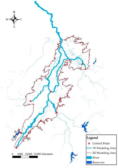
Figure 4.
1D and 2D hydrodynamic modeling area.
4. Results and Discussions
4.1. Model Simulation Results
It can be seen from Table 5 that the Xin’anjiang model shows a good performance in simulating the runoff process in the upstream mountainous areas. The relative errors between the observed data and the simulation results are all less than 20%. The deterministic coefficients for all flood process simulations are greater than 0.7, except for one flood event (No. 20110613) at the Zhuji hydrological station. The lower coefficient for flood No. 20110613 is probably due to the slow flood recession caused by extreme rainfall, as the Xin’anjiang model could not meet the accuracy requirements for the flood recession simulation.

Table 5.
Validation results of the Xin’anjiang model.
Using the calibrated coefficients for the model validation, the absolute errors between the observed and simulated water levels at Zhuji and Meichi hydrological stations are less than 0.2 m, and the relative errors of discharge are less than 20%, which is acceptable (see Table 6). The hydrological-hydrodynamic model shows an accurate simulation result of the flood peak and the process of the flood recession during the No. 20110613 historical flood (see Figure 5). Therefore, the hydrological-hydrodynamic model is considered to be feasible and can be applied to the Puyang River catchment.

Table 6.
Simulation results of the 1D hydrodynamic model for the historical flood No.20110613.
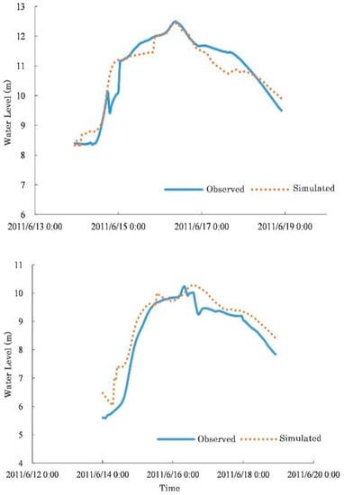
Figure 5.
Hydrographs of the historical flood No. 20110613 at Zhuji (above) and Meichi (below) hydrological stations.
The lakes and cultivated fields along the Puyang River are the key protection areas. Due to the tidal effects, the downstream area of the Meichi hydrological station has a longer duration of high-water levels during rainfall, which puts more pressure on the flood control in this region. To improve this situation, Zhuji City regenerated the flood storage and detention area of Gao Lake for flood diversion at midstream. Meanwhile, the embankment standard is also upgraded. Considering the impacts of the changes in the hazard factors and the hydraulic engineering infrastructures, two scenarios are set, which are the combination of floods and tides and historical flood events. For each scenario, different sub-scenarios are simulated. The sub-scenarios under the combination of the floods and tides are set according to the Flood Control Plan of Puyang River Catchment (2019) [30] that is issued by Water Authority of Zhejiang Province. The design storms with five different return periods (T = 5, 10, 20, 50, 100 years) are considered. The descriptions for each sub-scenario are shown in Table 7. In total, there are nine sub-scenarios.

Table 7.
Flood scenario description of the Puyang River basin.
4.2. Scenario 1: Combination of Floods and Tides
The simulation results of scenario 1 are shown in Figure 6, with different return periods of the design storms (5, 10, 20, 50, and 100 years). The inundation areas and flood depths are analyzed for each sub-scenario, and the parallel comparisons between sub-scenarios are carried out (see Table 8).
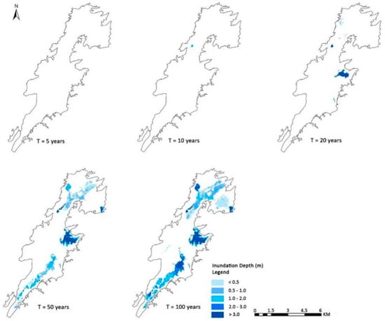
Figure 6.
Inundation maps of the five sub-scenarios of scenario 1.

Table 8.
Comparison of the simulation results of the five sub-scenarios.
From the flood depth map, there is no flood inundation under the design storm with a return period of five years. For the flood with a return period of 10 years, most areas in the catchment are well protected, even the downstream tides are unfavorable and the flood diversion at Gao Lake is not operated. Under this scenario, only Zangma Lake and Yuetang Lake are inundated. When the flood with a return period of 20 years and high tides are combined, the safety of the majority in the catchment can be under control except for a few reaches. However, there are risks of dykes breaking and overtopping in the areas with standard 10 year flood protection. Under this scenario, the dykes breaking in some areas can divert the flood to some extent, which protects other risky areas that are more developed.
During the floods of 50 years and 100 years, when there are high tides downstream, most of the low-lying lakes and fields along the river are inundated due to the dyke breaches. The water level reaches 11 m in Gao Lake, under these scenarios. If the flood return period is over 100 years, only the downtown area of Zhuji City is safe. The inundation area is 65.94 km2, posing high risks of life and economic losses. The simulated maximum flood level at Zhuji hydro-station reaches to 13.75 m (designed level 13.83 m), while the maximum flood level at the Meichi hydro-station reaches 11.11 m (designed level 11.3 m). In this case, the government has to implement an emergency response plan to avoid any potential losses.
4.3. Scenario 2: Historical Flood Events
The Gao Lake flood detention area is regenerated by the city to improve the capacity of flood prevention and regulation. In scenario 2, different historical flood events are simulated by the hydrological-hydrodynamic model (see Figure 7). The results are compared to evaluate the flood detention performance of Gao Lake (see Table 9). Historical floods are applied for simulating two cases. The first is the historical flood restoration, which aims to analyse the flood inundation caused by the actual dyke breaches. The other is the historical flood recurrence, which is to simulate the flood inundation if the historical floods recur under current conditions. In 1997 and 2011, many lakes and agricultural lands were inundated, due to flood disasters. Hence, two typical historical flood events, which occurred on the 9th of July 1997 and the 13th of June 2011, are selected for the simulation.
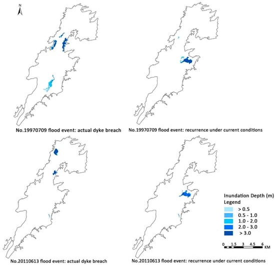
Figure 7.
Inundation maps of the historical scenario.

Table 9.
Flood simulation results comparison between the historical and current situations.
The simulation results show that both the inundation area and flood depth are significantly reduced under the scenarios of the dyke reinforcement and operation of the flood diversion at Gao Lake. Historically, the 1997 flood event had a great impact on the catchment, leading to a 13.76 km2 area inundated and with a maximum flood depth of over 3 m. Considering the reinforcements of the flood protection system, the inundation area is significantly reduced to 1.07 km2, under the current situation if the 1997 flood event reoccurs. Similarly, the simulation results of the reoccurrence of the 2011 flood event show limited impacts on the catchment. With the diversion at Gao Lake, the whole catchment is well protected.
The upgrading and reinforcement of the current embankments can effectively protect the low-lying areas. Meanwhile, the flood diversion at midstream can reduce the potential risks of losses, which is essential for the emergency response. However, there are still a few sections of embankments that cannot meet the protection standard, which makes inner-dyke areas prone to flooding. These areas will be the priority of the flood control planning in the Puyang River catchment, in the future.
5. Conclusions
Due to the impacts of several uncertainty factors in the Puyang River catchment, e.g., downstream tides and hazard factors, a single model cannot accurately simulate the flooding process. The paper develops a Xin’anjiang hydrological and IFMS hydrodynamic model for the flood simulation in the Puyang River catchment. Following the calibration and validation of the model, it is applied to simulate the different scenarios and analyse the impacts of the change in the hazard factors and the upgrade of hydraulic engineering infrastructures. Some conclusions can be drawn from the simulation results. First, the model shows a good performance in reflecting the hydrological and hydrodynamic characteristics in the Puyang River catchment, which provides an innovative insight for flood simulations in the catchments with complex terrains. Secondly, flood disasters in the Puyang River catchment are closely linked to extreme rainfall. Under the current flood prevention standards, when floods with a return period of over 50 years occur, the emergency response is essential to reduce losses, in addition to flood control and regulation. Thirdly, flood diversion at midstream at Gao Lake is key to reducing the downstream flood risks. It indicates that the cascading flood detention and optimal flood regulation can effectively alleviate the flood control pressure in the catchment. In the future, the feasibility of the joint operations of the upstream reservoirs, midstream flood detention areas and the downstream pump stations can be considered. By integrating the flood control operation and management of the upstream and downstream areas, the flood prevention capacity can be enhanced.
Author Contributions
Conceptualization, H.Z.; methodology, B.Z. and X.W.; validation, X.Q. and T.M.; formal analysis, B.Z. and H.Z.; resources, X.Q. and T.M.; writing—original draft preparation, H.Z. and B.Z.; writing—review and editing, S.Q. and W.F.; visualization, X.W. and H.S. All authors have read and agreed to the published version of the manuscript.
Funding
This work is financially supported by the projects of the Zhejiang Key Research and Development Program (2021C03017); Water Conservancy Science and Technology Foundation of Jiangsu Province (No. 2020024); National Natural Science Foundation of China (52079079, U2240203).
Institutional Review Board Statement
Not applicable.
Informed Consent Statement
Not applicable.
Data Availability Statement
Not applicable.
Conflicts of Interest
The authors declare no conflict of interest.
References
- Meli, M.; Romagnoli, C. Evidence and Implications of Hydrological and Climatic Change in the Reno and Lamone River Basins and Related Coastal Areas (Emilia-Romagna, Northern Italy) over the Last Century. Water 2022, 14, 2650. [Google Scholar] [CrossRef]
- van Vliet, M.T.; Franssen, W.H.; Yearsley, J.R.; Ludwig, F.; Haddeland, I.; Lettenmaier, D.P.; Kabat, P. Global river discharge and water temperature under climate change. Glob. Environ. Chang. 2013, 23, 450–464. [Google Scholar] [CrossRef]
- Guerriero, L.; Ruzza, G.; Calcaterra, D.; Di Martire, D.; Guadagno, F.M.; Revellino, P. Modelling Prospective Flood Hazard in a Changing Climate, Benevento Province, Southern Italy. Water 2020, 12, 2405. [Google Scholar] [CrossRef]
- Gigović, L.; Pamučar, D.; Bajić, Z.; Drobnjak, S. Application of GIS-Interval Rough AHP Methodology for Flood Hazard Mapping in Urban Areas. Water 2017, 9, 360. [Google Scholar] [CrossRef]
- Cea, L.; Costabile, P. Flood Risk in Urban Areas: Modelling, Management and Adaptation to Climate Change. A Review. Hydrology 2022, 9, 50. [Google Scholar] [CrossRef]
- Jiménez Cisneros, B.E.; Oki, T.; Arnell, N.W.; Benito, G. Freshwater resources. In Climate Change 2014: Impacts, Adaptation, and Vulnerability, Part A: Global and Sectoral Aspects; Field, C.B., Barros, V., Dokken, D., Mach, K., Eds.; Contribution of Working Group II to the Fifth Assessment Report of the Intergovernmental Panel on Climate Change; Cambridge University Press: Cambridge, UK, 2014. [Google Scholar]
- Hirabayashi, Y.; Mahendran, R.; Koirala, S.; Konoshima, L.; Yamazaki, D.; Watanabe, S.; Kim, H.; Kanae, S. Global flood risk under climate change. Nat. Clim. Chang. 2013, 3, 816–821. [Google Scholar] [CrossRef]
- Hirabayashi, Y.; Kanae, S.; Emori, S.; Oki, T.; Kimoto, M. Global projections of changing risks of floods and droughts in a changing climate. Hydrol. Sci. J. 2008, 53, 754–772. [Google Scholar] [CrossRef]
- Zhao, R.J. The Xin’anjiang model applied in China. J. Hydrol. 1992, 135, 371–381. [Google Scholar]
- Ikeuchi, H.; Hirabayashi, Y.; Yamazaki, D.; Kiguchi, M.; Koirala, S.; Nagano, T.; Kotera, A.; Kanae, S. Modeling complex flow dynamics of fluvial floods exacerbated by sea level rise in the Ganges–Brahmaputra–Meghna Delta. Environ. Res. Lett. 2015, 10, 124011. [Google Scholar] [CrossRef]
- David, A.; Schmalz, B. Flood hazard analysis in small catchments: Comparison of hydrological and hydrodynamic approaches by the use of direct rainfall. J. Flood Risk Manag. 2020, 13, e12639. [Google Scholar] [CrossRef]
- Chomba, I.C.; Banda, K.E.; Winsemius, H.C.; Chomba, M.J.; Mataa, M.; Ngwenya, V.; Sichingabula, H.M.; Nyambe, I.A.; Ellender, B. A review of coupled hydrologic-hydraulic models for floodplain assessments in Africa: Opportunities and challenges for floodplain wet-land management. Hydrology 2021, 8, 44. [Google Scholar] [CrossRef]
- Zeng, Z.Q.; Yang, M.X.; Lei, X.H.; Liang, J.; Yuan, X.H.; Pan, C. A review of hydrological-hydrodynamic coupling models for river-basin systems. China Rural. Water Hydropower 2017, 9, 72–76. [Google Scholar]
- Zhang, Y.; Zhou, J.; Lu, C. Integrated Hydrologic and Hydrodynamic Models to Improve Flood Simulation Capa-bility in the Data-Scarce Three Gorges Reservoir Region. Water 2020, 12, 1462. [Google Scholar] [CrossRef]
- Jha, M.K.; Afreen, S. Flooding Urban Landscapes: Analysis Using Combined Hydrodynamic and Hydrologic Modeling Approaches. Water 2020, 12, 1986. [Google Scholar] [CrossRef]
- Chen, Y.-M.; Liu, C.-H.; Shih, H.-J.; Chang, C.-H.; Chen, W.-B.; Yu, Y.-C.; Su, W.-R.; Lin, L.-Y. An Operational Forecasting System for Flash Floods in Mountainous Areas in Taiwan. Water 2019, 11, 2100. [Google Scholar] [CrossRef]
- Hoch, J.M.; Eilander, D.; Ikeuchi, H.; Baart, F.; Winsemius, H.C. Evaluating the impact of model complexity on flood wave propagation and inundation extent with a hydrologic–hydrodynamic model coupling framework. Nat. Hazards Earth Syst. Sci. 2019, 19, 1723–1735. [Google Scholar] [CrossRef]
- Brandmeyer, J.E.; Karimi, H.A. Coupling methodologies for environmental models. Environ. Model. Softw. 2000, 15, 479–488. [Google Scholar] [CrossRef]
- Chang, L.; Liu, K.L.; Yao, C. Real-time flood forecasting system for complicated river channels: A case study from Wangjiaba to Xiaoliuxiang section in the Huaihe River basin. J. Lake Sci. 2013, 25, 422–427. [Google Scholar]
- Ruan, S.; Li, G.C. Hydrologic-hydraulic coupling model and its application. China Rural. Water Hydropower 2013, 2013, 9–11+15. [Google Scholar]
- Han, C.; Mei, Q.; Liu, S.G. Research and application on a coupled hydrological and hydrodynamic model in plain tidal river network. Chin. J. Hydrodyn. 2014, 29, 706–712. [Google Scholar]
- Liu, L.; Xu, Z.X. Hydro-dynamic simulation of flood in the Taihu Basin. J. Beijing Norm. Univ. (Nat. Sci.) 2012, 48, 530–536. [Google Scholar]
- Dong, P. Analysis of drainage modulus in drainage area of Hunhe river basin based on hydrohydrodynamic coupling model. Tech. Superv. Water Resour. 2018, 2018, 145–148. [Google Scholar]
- Luo, W.B.; Wang, X.G.; Qiao, W. Effects of land-use change on drainage modulus in plain lake area based on a coupled hydrological and hydrodynamic model. J. Yangtze River Sci. Res. Inst. 2018, 35, 76–81. [Google Scholar]
- Yin, Z.E.; Yin, J.; Xu, S.; Wen, J. Community-based scenario modelling and disaster risk assessment of urban rain-storm waterlogging. J. Geogr. Sci. 2011, 21, 274–284. [Google Scholar] [CrossRef]
- Nogherotto, R.; Fantini, A.; Raffaele, F.; Di Sante, F.; Dottori, F.; Coppola, E.; Giorgi, F. A combined hydrological and hydraulic modelling approach for the flood hazard mapping of the Po river basin. J. Flood Risk Manag 2021, 15, e12755. [Google Scholar] [CrossRef]
- Yu, H.J.; Ma, J.M.; Zhang, D.W.; Mu, J. Application of IFMS Urban software in urban flood risk mapping. China Flood Drought Manag. 2018, 28, 13–17. [Google Scholar]
- The People’s Government of Zhuji. Flood Prevention and Drought Control Manual in Zhuji; The People’s Government of Zhuji: Zhuji, China, 2018.
- Wang, Z.L.; Geng, Y.F.; Jin, S. The two-dimensional flood routing simulation. Chin. J. Comput. Mech. 2007, 2007, 533–538. [Google Scholar]
- The People’s Government of Zhejiang Province. Flood Control Plan of Puyang River Catchment; The People’s Government of Zhejiang Province: Hangzhou, China, 2019.
Publisher’s Note: MDPI stays neutral with regard to jurisdictional claims in published maps and institutional affiliations. |
© 2022 by the authors. Licensee MDPI, Basel, Switzerland. This article is an open access article distributed under the terms and conditions of the Creative Commons Attribution (CC BY) license (https://creativecommons.org/licenses/by/4.0/).