
Mapping Groundwater Potential Zones Using Analytical Hierarchical Process and Multicriteria Evaluation in the Central Eastern Desert, Egypt


Abstract
:1. Introduction
2. Materials and Methods
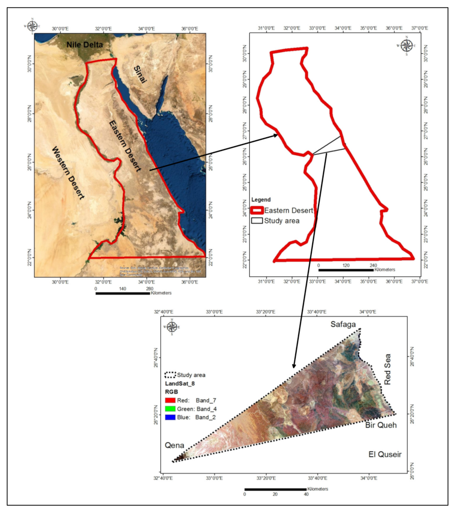
2.1. Study Area
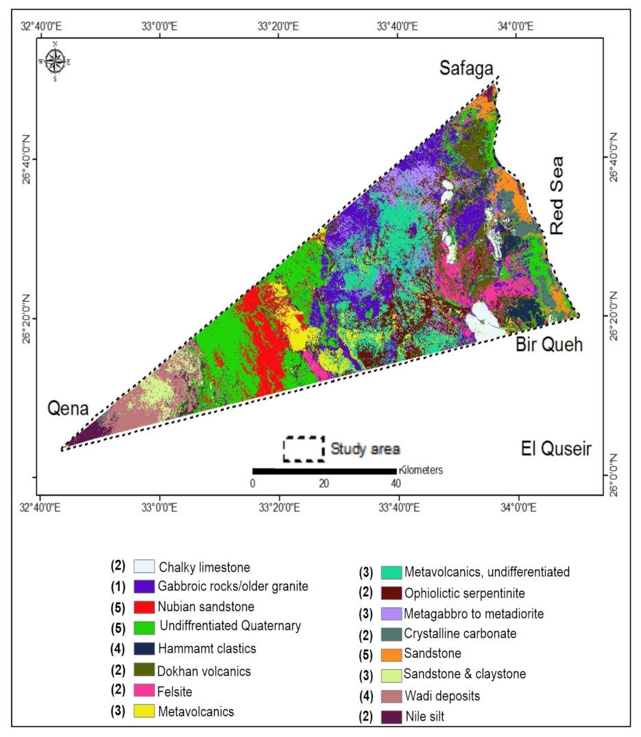
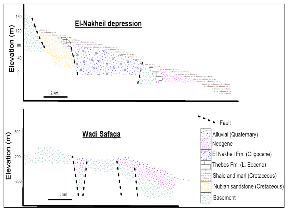
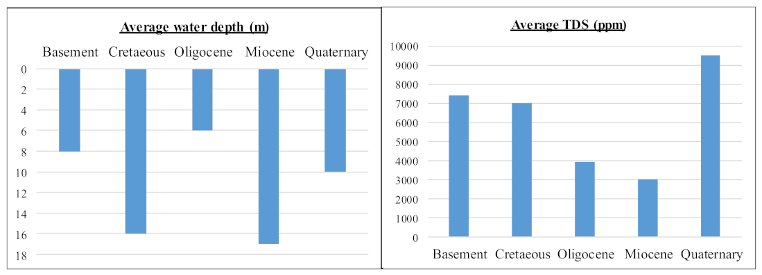
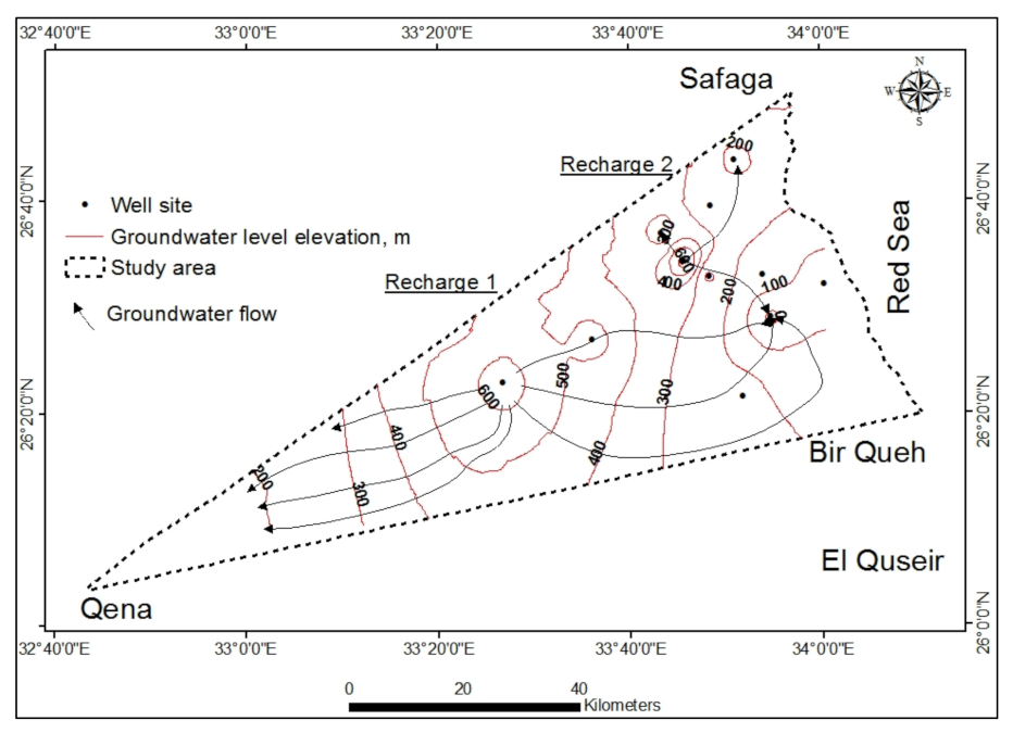
Geology and Hydrogeology
2.2. Data Sets
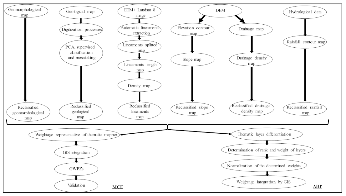
2.3. Methodology
3. Results and Discussions
3.1. Groundwater Potential Parameters
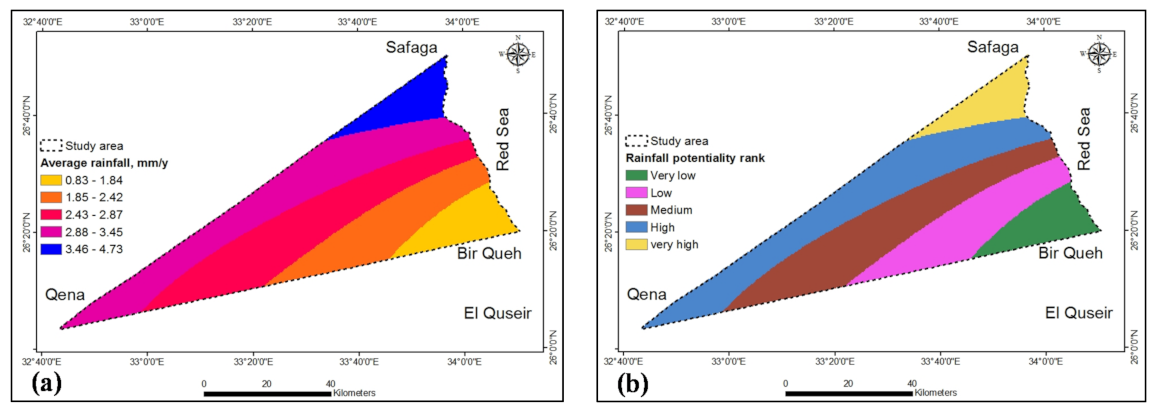
3.1.1. Rainfall
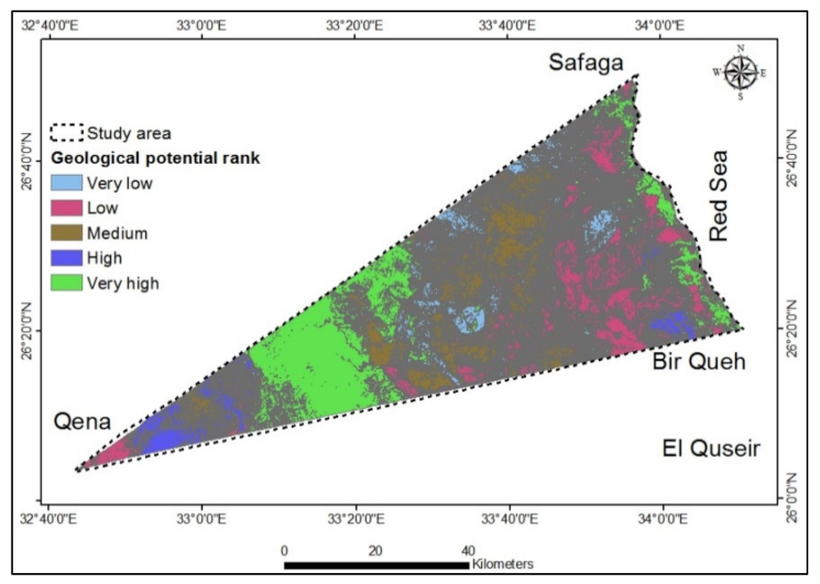
3.1.2. Geology
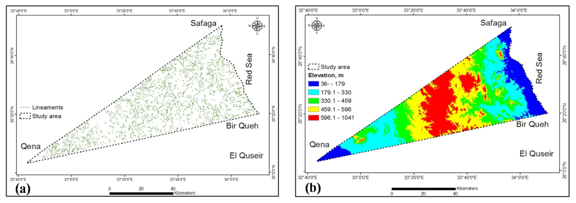
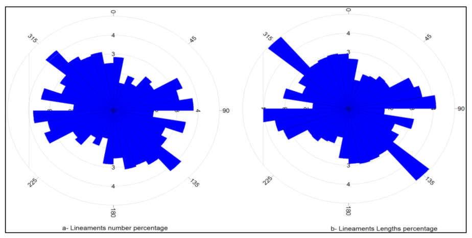
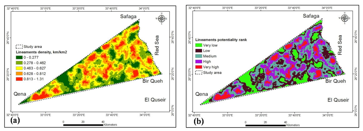
3.1.3. Rock Fractures
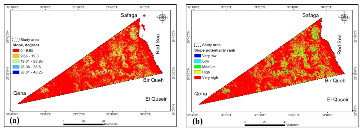
3.1.4. Slope
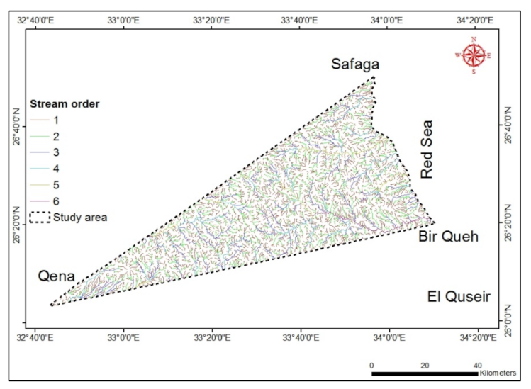
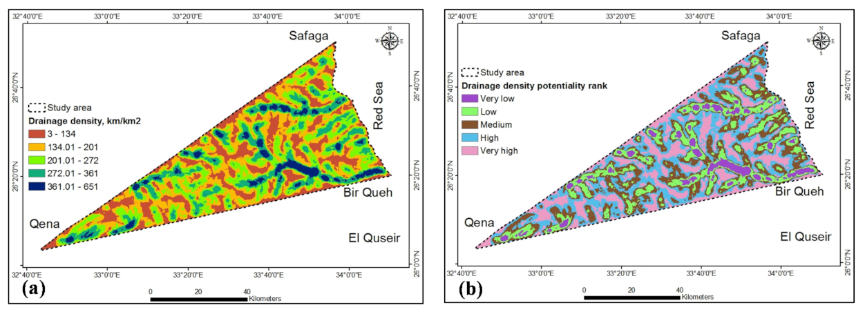
3.1.5. Drainage Density
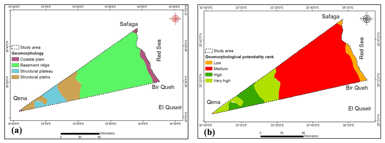
3.1.6. Geomorphology
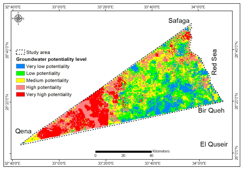
3.2. GWPZs Mapping
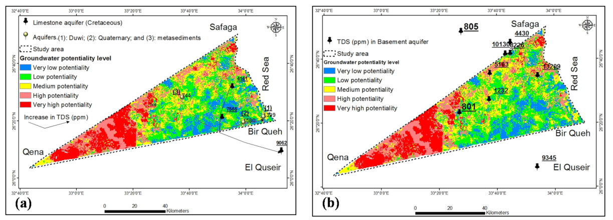
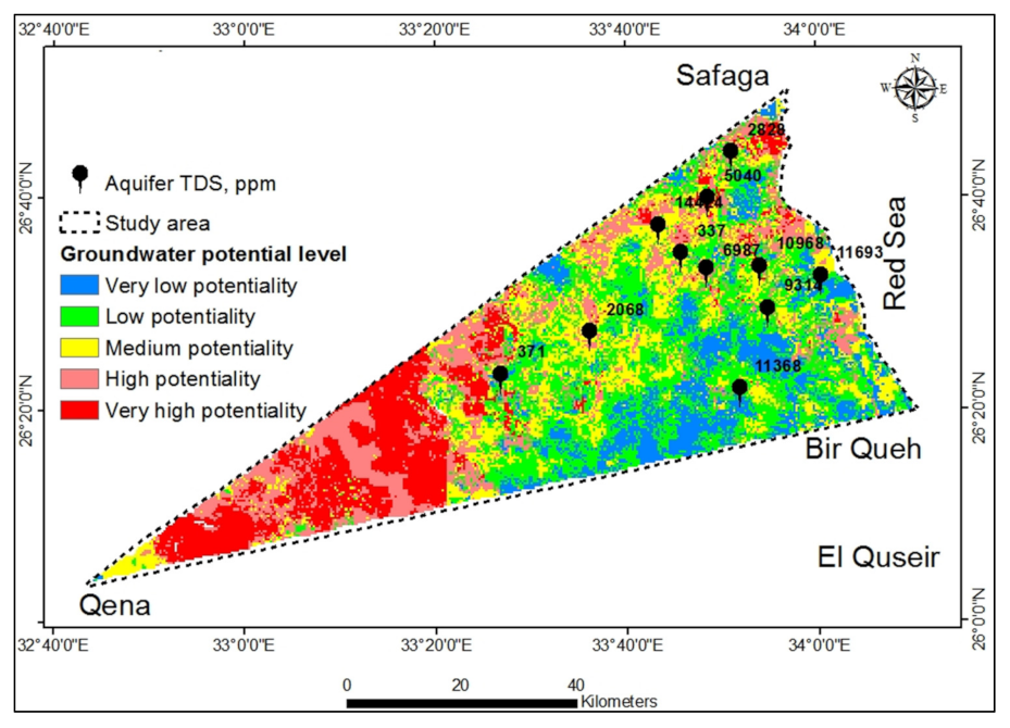
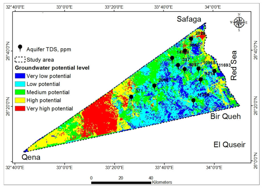
3.2.1. GWPZs by MCE and Its Validation
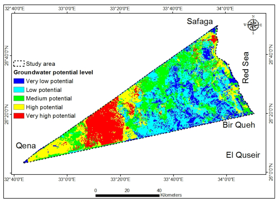
3.2.2. GWPZs by AHP and Its Validation
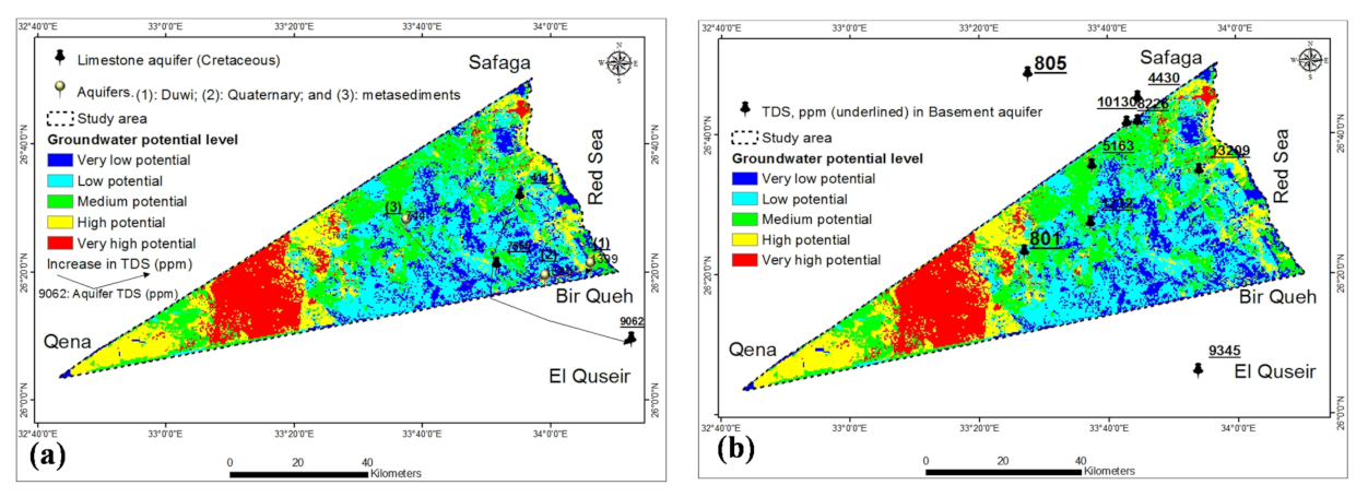
3.3. Comparison between MCE and AHP Techniques
4. Conclusions
Supplementary Materials
Author Contributions
Funding
Institutional Review Board Statement
Informed Consent Statement
Data Availability Statement
Conflicts of Interest
References
- Gaber, A.; Koch, M.; Griesh, M.H.; Sato, M. SAR Remote sensing of buried faults: Implications for groundwater exploration in the Western Desert of Egypt. Sens. Imaging Int. J. 2011, 12, 133–151. [Google Scholar] [CrossRef]
- IPCC. Climate Change 2007: The Physical Science Basis. In Contribution of Working Group I to the Fourth Assessment Report of the Intergovernmental Panel on Climate Change; Solomon, S., Qin, D., Manning, M., Chen, Z., Marquis, M., Averyt, K.B., Tignor, M., Miller, H.L., Eds.; Cambridge University Press: Cambridge, UK; New York, NY, USA, 2007; 996p. [Google Scholar]
- Gheith, H.; Sultan, M. Construction of a hydrologic model for estimating Wadi runoff and groundwater recharge in the Eastern Desert, Egypt. J. Hydrol. 2002, 263, 36–55. [Google Scholar] [CrossRef]
- Mosaad, S. Geomorphologic and geologic overview for water resources development: Kharit basin, Eastern Desert, Egypt. J. Afr. Earth Sci. 2017, 134, 56–72. [Google Scholar] [CrossRef]
- Naim, G. Floods of Upper Egypt Governorates; Egyptian Geological Survey and Mining Authority: Cairo, Egypt, 1995. [Google Scholar]
- Agarwal, R.; Garg, P. Remote sensing and GIS based groundwater potential & recharge zones mapping using multi-criteria decision making technique. Water Resour. Manag. 2016, 30, 243–260. [Google Scholar]
- Sander, P.; Minor, T.B.; Chesley, M.M. Ground-water exploration based on lineament analysis and reproducibility tests. Groundwater 1997, 35, 888–894. [Google Scholar] [CrossRef]
- Eastman, J.R. Multi-Criteria Evaluation and Geographical Informationn Systems; Longley, P.A., Goodchild, M.F., Magurie, D.J., Rhind, D.W., Eds.; John Wiley and Sons: New York, NY, USA, 1996; Volume 1, pp. 493–502. [Google Scholar]
- Taheri, A.; Zare, M. Groundwater artificial recharge assessment in Kangavar Basin, a semi-arid region in the western part of Iran. Afr. J. Agric. Res. 2011, 6, 4370–4384. [Google Scholar]
- Chowdhury, A.; Jha, M.K.; Chowdary, V.M. Delineation of groundwater recharge zones and identification of artificial recharge sites in West Medinipur district, West Bengal, using RS, GIS and MCDM techniques. Environ. Earth Sci. 2010, 59, 1209–1222. [Google Scholar] [CrossRef]
- Meshram, K.S. Effect of Artificial Recharge Structures on Ground Water Availability in Semi-critical Area in Chhattisgarh. Ph.D. Thesis, Indira Gandhi KrishiVishwavidyalaya, Raipur, India, 2010; pp. 4–23. [Google Scholar]
- Samson, S.; Elangovan, K. Delineation of groundwater recharge potential zones in Namakkal District, Tamilnadu, India using remote sensing and GIS. J. Indian Soc. Remote Sens. 2015, 43, 769–778. [Google Scholar] [CrossRef]
- Deepika, B.; Avinash, K.; Jayappa, K.S. Integration of hydrological factors and demarcation of groundwater prospect zones: Insights from remote sensing and GIS techniques. Environ. Earth Sci. 2013, 70, 1319–1338. [Google Scholar] [CrossRef]
- Deepa, S.; Venkateswaran, S.; Ayyandurai, R.; Kannan, R.; Prabhu, M.V. Groundwater recharge potential zones mapping in upper Manimuktha Sub basin Vellarriver Tamil Nadu India using GIS and remote sensing techniques. Modeling Earth Syst. Environ. 2016, 2, 137. [Google Scholar] [CrossRef] [Green Version]
- Machiwal, D.; Rangi, N.; Sharma, A. Integrated knowledge- and data-driven approaches for groundwater potential zoning using GIS and multi-criteria decision making techniques on hard-rock terrain of Ahar catchment, Rajasthan, India. Environ. Earth Sci. 2015, 73, 1871–1892. [Google Scholar] [CrossRef]
- El Mekki, O.A.; Laftouhi, N.-E. Combination of a geographical information system and remote sensing data to map groundwater recharge potential in arid to semi-arid areas: The Haouz Plain, Morocco. Earth Sci. Inform. 2016, 9, 465–479. [Google Scholar] [CrossRef]
- Voogd, H. Multi-Ctiteria Evaluation for Urban and Regional Planning, Pion, London. Water Resour. Manag. 1983, 24, 921–939. [Google Scholar]
- Todd, D.K.; Mays, L.W. Groundwater Hydrology, 3rd ed.; John Wiley & Sons: Hoboken, NJ, USA, 2013. [Google Scholar]
- Adiat, K.A.N.; Nawawi, M.N.M.; Abdullah, K. Assessing the accuracy of GIS-based elementary multi-criteria decision analysis as a spatial prediction tool—a case of predicting potential zones of sustainable groundwater resources. J. Hydrol. 2012, 440, 75–89. [Google Scholar] [CrossRef]
- Pradhan, R.M.; Guru, B.; Pradhan, B.; Biswal, T.K. Integrated multi-criteria analysis for groundwater potential mapping in Precambrian hard rock terranes (North Gujarat), India. Hydrol. Sci. J. 2021, 66, 961–978. [Google Scholar] [CrossRef]
- Roy, S.; Hazra, S.; Chanda, A.; Das, S. Assessment of groundwater potential zones using multi-criteria decision-making technique: A micro-level case study from red and lateritic zone (RLZ) of West Bengal, India. Sustain. Water Resour. Manag. 2020, 6, 4. [Google Scholar] [CrossRef]
- Jothibasu, A.; Anbazhagan, S. Modeling groundwater probability index in Ponnaiyar River basin of South India using analytic hierarchy process. Model. Earth Syst. Environ. 2016, 2, 109. [Google Scholar] [CrossRef] [Green Version]
- Khan, M.Y.A.; ElKashouty, M.; Subyani, A.M.; Tian, F.; Gusti, W. GIS and RS intelligence in delineating the groundwater potential zones in Arid Regions: A case study of southern Aseer, southwestern Saudi Arabia. Appl. Water Sci. 2022, 12, 3. [Google Scholar] [CrossRef]
- Saaty, T.L. The Analytic Hierarchy Process: Planning, Priority Setting, Resources Allocation; McGraw: New York, NY, USA, 1980. [Google Scholar]
- Abdalla, F. Mapping of groundwater prospective zones using remote sensing and GIS techniques: A case study from the Central Eastern Desert, Egypt. J. Afr. Earth Sci. 2012, 70, 8–17. [Google Scholar] [CrossRef]
- Said, R. The Geology of Egypt; Elesvier Publication: Amsterdam, The Netherlands, 1962. [Google Scholar]
- Said, R. The Geology of Egypt; Balkema, A.A., Ed.; Brookfield: Rotterdam, The Netherlands, 1990; p. 734. [Google Scholar]
- El Ramly, I.M. Final Report on Geomorphology, Hydrology Planning for Groundwater Resources and Reclamation in Lake Nasser Region and Its Environs; Cen And Des Inst.: Cairo, Egypt, 1972; p. 603. [Google Scholar]
- EGPC/Conoco. Photogeological Interpretation Map, Scale (1: 100,000); CORALI: Cairo, Egypt, 1987. [Google Scholar]
- Gomaa, M.A. Hydrogeological Studies between Quesir-Safagaarea, Eastern Desert, Egypt. Master’s Thesis, Ain Shams Univ., Cairo, Egypt, 1992; p. 172. [Google Scholar]
- ElKashouty, M. Watershed delineation and morphometric analysis using remote sensing and GIS mapping techniques in Qena-Safaga-BirQueh, Central Eastern Desert. Int. J. Water Resour. Environ. Eng. 2020, 12, 22–46. [Google Scholar]
- El Shazly, E.M. The geology of the Egyptian region. In The Ocean Basins and Margins; Springer: Boston, MA, USA, 1977; pp. 379–444. [Google Scholar]
- Gomaa, M.D.; Meraj, N.M.; Khaled, A.A. Assessment of several flood estimation methodologies in Makkah metropolitan area, Saudi Arabia. Arab. J. Geosci. 2013, 6, 985–993. [Google Scholar]
- Moneim, A.A.A.; Seleem, E.M.; Zeid, S.A.; Samie, S.G.A.; Zaki, S.; Abu El-Fotoh, A. Hydrogeochemical characteristics and age dating of groundwater in the Quaternary and Nubian aquifer systems in Wadi Qena, Eastern Desert, Egypt. Sustain. Water Resour. Manag. 2015, 1, 213–232. [Google Scholar] [CrossRef] [Green Version]
- Elbeih, S.F.; Belal, A.A.B.; Zaghloul, E.S.A. Hazards mitigation and natural resources evaluation around Sohag–Safaga highway, Eastern Desert, Egypt. Egypt. J. Remote Sens. Space Sci. 2011, 14, 15–28. [Google Scholar] [CrossRef] [Green Version]
- Abdalla, F.A.; Khalifa, I.H. Effects of phosphate mining activity on groundwater quality at WadiQueh, Red Sea, Egypt. Arab. J. Geosci. 2013, 6, 1273–1282. [Google Scholar] [CrossRef]
- Eastman, J.R.; Jin, W.; Kyem, A.K.; Toledano, J. Raster Procedures for Multi-Criteria/Multi-Objective Decisions. Photogramm. Eng. Remote Sens. 1995, 61, 539–547. [Google Scholar]
- O’leary, D.W.; Friedman, J.D.; Pohn, H.A. Lineament, linear, lineation: Some proposed new standards for old terms. Geol. Soc. Am. Bull. 1976, 87, 1463–1469. [Google Scholar] [CrossRef]
- Edet, A.E.; Okereke, C.S.; Teme, S.C.; Esu, E.O. Application of remote-sensing data to groundwater exploration: A case study of the Cross-River State, southeastern Nigeria. Hydrogeol. J. 1998, 6, 394–404. [Google Scholar] [CrossRef]
- Pradeep, R. Remote sensing techniques to locate ground water potential zones in upper Urmil River Basin, District Chhatarpur—Central India. J. Indian Soc. Remote Sens. 1998, 26, 135–147. [Google Scholar]
- Sreedhar, G. Mapping of groundwater potential zones in the Musi basin using remote sensing data and GIS. Adv. Eng. Softw. 2009, 40, 506–518. [Google Scholar]
- Al Saud, M. Mapping potential areas for groundwater storage in WadiAurnah Basin, western Arabian Peninsula, using remote sensing and geographic information system techniques. Hydrogeol. J. 2010, 18, 1481–1495. [Google Scholar] [CrossRef]
- Das, B.; Pal, S.C. Assessment of groundwater recharge and its potential zone identification in groundwater-stressed Goghat-I block of Hugli District, West Bengal, India. Environ. Dev. Sustain. 2020, 22, 5905–5923. [Google Scholar] [CrossRef]
- Strahler, A.N. Quantitative geomorphology of drainage basins and channel networks. In Handbook of Applied Hydrology; Chow, V.T., Ed.; McGraw Hill Book Company: New York, NY, USA, 1964; pp. 4–11. [Google Scholar]
- Horton, R.E. Drainage basin characteristics. Trans. Am. Geophys. Union 1932, 13, 348–352. [Google Scholar] [CrossRef]
- Patra, S.; Mishra, P.; Mahapatra, S.C. Delineation of groundwater potential zone for sustainable development: A case study from Ganga Alluvial Plain covering Hooghly district of India using remote sensing, geographic information system and analytic hierarchy process. J. Clean. Prod. 2018, 172, 2485–2502. [Google Scholar] [CrossRef]
- Butler, M.; Wallace, J.; Lowe, M. Ground-Water Quality Classification Using GIS Contouring Methods for Cedar Valley, Iron County, Utah. Digit. Mapp. Tech. 2002, 2, 207. [Google Scholar]
- Asadi, S.S.; Vuppala, P.; Reddy, M.A. Remote sensing and GIS techniques for evaluation of groundwater quality in municipal corporation of Hyderabad (Zone-V), India. Int. J. Environ. Res. Public Health 2007, 4, 45–52. [Google Scholar] [CrossRef] [Green Version]
- Yammani, S. Groundwater quality suitable zones identification: Application of GIS, Chittoor area, Andhra Pradesh, India. Environ. Earth Sci. 2007, 53, 201–210. [Google Scholar] [CrossRef]


| Ranges of Lineaments Length (m) | |||||||
|---|---|---|---|---|---|---|---|
| 3.6–523 | 523.1–1001 | 1001–1500 | 1500–2003 | 2003–2571 | 2571–2925 | 3870.5 | |
| Count: | 913 | 1023 | 722 | 119 | 29 | 9 | 1 |
| Minimum: | 3.6 | 502.9 | 1001.3 | 1500.3 | 2003.1 | 2571.1 | - |
| Maximum: | 502.9 | 1001.3 | 1500 | 2003.1 | 2571.1 | 2925.3 | - |
| Sum: | 334,356.1 | 786,459 | 846,725.1 | 200,890.4 | 64,063.7 | 24,612 | 3870.5 |
| Mean: | 366.2 | 768.8 | 1172.7 | 1688.2 | 2209.1 | 2734.7 | - |
| Standard Deviation: | 99.3 | 175.7 | 128.2 | 142.2 | 147.8 | 128.9 | - |
| Total lineaments lengths = 2,260,976.8 m | |||||||
| Lengths of Orders (m) | ||||||
|---|---|---|---|---|---|---|
| 1st Order | 2nd Order | 3rd Order | 4th Order | 5th Order | 6th Order | |
| Count: | 2859 | 1301 | 747 | 324 | 166 | 73 |
| Minimum: | 4.6 | 57.3 | 44 | 44 | 124.5 | 44 |
| Maximum: | 9999.5 | 5301.7 | 5040.5 | 6964.8 | 2433.9 | 3721.4 |
| Sum: | 2,747,627.2 | 1,223,748 | 662,852.6 | 288,390.6 | 128,068.7 | 57,225.9 |
| Mean: | 961 | 940.6 | 887.4 | 890.1 | 771.5 | 783.9 |
| Standard Deviation: | 810.8 | 748 | 698.6 | 773.6 | 533.7 | 622 |
| Total stream lengths = 5,107,912.9 m | ||||||
| MCE | AHP | |||
|---|---|---|---|---|
| GWPZs | Area (km2) | Area (%) | Area (km2) | Area (%) |
| Very low | 580.3 | 14.3 | 259.7 | 6.1 |
| Low | 1172.3 | 29 | 1138.6 | 26.9 |
| Medium | 825.7 | 20.4 | 1479.3 | 34.9 |
| High | 780.7 | 19.3 | 693.4 | 16.4 |
| Very high | 686.6 | 17 | 667.2 | 15.7 |
| Aquifer Type | TDS (ppm) | MCE Method | AHP Method |
|---|---|---|---|
| Metasediments | 744 | High potential | Medium Potential |
| Quaternary | 1580 | Outside | Outside |
| Duwi | 1399 | High potential | Low potential |
| Limestone | 4141 | Low potential | Very low potential |
| Limestone | 7565 | Very low potential | Very low potential |
| Limestone | 9062 | Outside | Outside |
| Basement | 805 | Outside | Outside |
| Basement | 4430 | Outside | Outside |
| Basement | 9345 | Outside | Outside |
| Basement | 801 | Very high potential | High potential |
| Basement | 1232 | Very high potential | High potential |
| Basement | 5163 | High potential | Medium Potential |
| Basement | 13,209 | Medium potential | Medium Potential |
| Basement | 8226 | Medium potential | Medium Potential |
| Basement | 10,130 | Medium potential | Medium Potential |
| Borehole Type | TDS (ppm) | MCE Method | AHP Method |
|---|---|---|---|
| Drilled | 2827.9 | Medium potential | Medium potential |
| Shaft | 11,693.4 | Low potential | Low potential |
| Shaft | 9313.89 | Low potential | Very low potential |
| Hand dug | 11,368.2 | Very low potential | Very low potential |
| Hand dug | 10,967.9 | Medium potential | Medium potential |
| Hand dug | 5040.49 | Medium potential | Medium potential |
| Drilled | 14,424.2 | Medium potential | Very low potential |
| Hand dug | 337.07 | Low potential | Low potential |
| Drilled | 6986.9 | Low potential | Medium potential |
| Drilled | 2068 | Medium potential | Medium potential |
| Hand dug | 371 | High potential | High potential |
| Parameters | Geomorphology | Geology | Lineaments | Slope | Drainage | Rainfall | Weight |
|---|---|---|---|---|---|---|---|
| Geomorphology | 6 | 5 | 4 | 3 | 2 | 1 | 0.41 |
| Geology | 6/2 | 5/2 | 4/2 | 3/2 | 2/2 | 1/2 | 0.2 |
| Lineaments | 6/3 | 5/3 | 4/3 | 3/3 | 2/3 | 1/3 | 0.14 |
| Slope | 6/4 | 5/4 | 4/4 | 3/4 | 2/4 | 1/4 | 0.1 |
| Drainage | 6/5 | 5/5 | 4/5 | 3/5 | 2/5 | 1/5 | 0.082 |
| Rainfall | 6/6 | 5/6 | 4/6 | 3/6 | 2/6 | 1/6 | 0.068 |
| Total | 1 |
Publisher’s Note: MDPI stays neutral with regard to jurisdictional claims in published maps and institutional affiliations. |
© 2022 by the authors. Licensee MDPI, Basel, Switzerland. This article is an open access article distributed under the terms and conditions of the Creative Commons Attribution (CC BY) license (https://creativecommons.org/licenses/by/4.0/).
Share and Cite
Khan, M.Y.A.; ElKashouty, M.; Tian, F. Mapping Groundwater Potential Zones Using Analytical Hierarchical Process and Multicriteria Evaluation in the Central Eastern Desert, Egypt. Water 2022, 14, 1041. https://doi.org/10.3390/w14071041
Khan MYA, ElKashouty M, Tian F. Mapping Groundwater Potential Zones Using Analytical Hierarchical Process and Multicriteria Evaluation in the Central Eastern Desert, Egypt. Water. 2022; 14(7):1041. https://doi.org/10.3390/w14071041
Chicago/Turabian StyleKhan, Mohd Yawar Ali, Mohamed ElKashouty, and Fuqiang Tian. 2022. "Mapping Groundwater Potential Zones Using Analytical Hierarchical Process and Multicriteria Evaluation in the Central Eastern Desert, Egypt" Water 14, no. 7: 1041. https://doi.org/10.3390/w14071041
APA StyleKhan, M. Y. A., ElKashouty, M., & Tian, F. (2022). Mapping Groundwater Potential Zones Using Analytical Hierarchical Process and Multicriteria Evaluation in the Central Eastern Desert, Egypt. Water, 14(7), 1041. https://doi.org/10.3390/w14071041