1. Introduction
In the context of rapid urbanization and global climate change, cities are facing many challenges such as rapid climate change, frequent flooding, and increased water pollution. BI can be implemented as a sustainable development strategy to address the urban environmental crisis and improve urban resilience, playing a role in all categories of ecosystem services (e.g., supporting, regulating, provisioning, and cultural) [
1]. BI is a network of aquatic ecosystems consisting of spaces and corridors covered by water bodies, which include natural or seminatural water bodies and artificially constructed water-bony surfaces [
2], such as rivers, lakes, wetlands, natural coastlines, reservoirs, artificial river embankment, artificial watercourses, etc. BI contributes to water purification, flood protection, and overall climate change adaptation, as well as provides various kinds of cultural ecosystem services [
3,
4,
5,
6]. BI also plays a key role in improving public health and people’s well-being, promoting regional economic development, and maintaining urban ecosystem services [
7,
8,
9]. However, the installation and use of BI depend on the different development needs of the city, such as alleviating urban flooding [
10,
11], promoting physical and mental health [
12,
13], and enhancing biodiversity [
14,
15], which are ultimately reflected in the design of urban BI. BI can offset the impacts of gray infrastructures, such as hardened roads, building construction, and drainage pipes which are common features in cities experiencing significant urban development. So is BI [
3]. However, there is rare evidence proving the value and ability of BI to provide ecosystem services for cities and their human population [
16].
In the last two decades, the concept of green infrastructure has gained attention. Apart from BI, green infrastructure also refers to natural or artificial green spaces such as forests, grasslands, plant and animal habitats, and farms that provide a wider range of ecosystem services to better address environmental issues and support human well-being [
17,
18,
19]. Therefore, BI is placed in the broader framework of green infrastructure research, called blue–green infrastructure [
20,
21]. However, as urbanization is gaining momentum, human activities are more frequent, urban construction is expanding, and water pollution is increasing [
22]. Against this backdrop, BI is exposed to fragmentation, and green corridor connections are weakening, in addition to facing the other difficulties associated with great area loss and quality degradation [
23]. This phenomenon has been hidden in the framework of the abroad discussion of green infrastructure. Therefore, it is imperative to study the spatial and temporal changes of BI network patterns in the context of rapid urbanization in order to assess its current status. In this manner, the targeted protection and restoration of the sustainable functions of BI ecosystem services can be carried out.
Currently, the main focus of BI research is on its ecological service functions [
24,
25,
26], value estimation [
26,
27], protection, and space optimization [
28,
29], with perspectives mainly drawn from environmental science, land management, ecology, and so on. According to the study results, BI is deeply affected by urbanization, and its ecological function is weakening greatly [
23,
30]. In addition, the number and quality of BI are dropping, which is mainly attributed to the greater need for grey infrastructure, dramatic climate change, and serious pollution associated with organic and inorganic compounds. In this context, building an urban BI network based on the natural capital is seen as the most profitable protection strategy for urban development and a key breakthrough to improving urban ecological services [
31,
32,
33].
In recent years, some experts have researched ecological networks of different kinds and dimensions from the point of view of landscape ecology theory. Several methods and models have been explored, including morphological spatial pattern analysis (MSPA) and minimum cumulative Resistance (MCR), which have been widely adopted [
34,
35,
36]. MSPA identifies ecological regions with high landscape connectivity from the pixel level through land use raster data; thus, the selection of BI sources can be more scientific. In the light of various resistance factors, such as topography and human activities, MCR models simulate the least cost path between sources by combining landscape connectivity indices, graph theory, and gravity models based on the geographic information system (GIS). The existing studies have conducted in-depth explorations in source selection, resistance factor selection, corridor importance identification, and network optimization [
37,
38], which provide an important reference for this study.
With the high-quality development of China’s economy, increasingly prominent environmental problems have attracted attention within political and academic circles. Under the guiding ideology of regional development integration proposed by the Chinese government, the research on the ecological economy at the scale of river basins has become a frontier hotspot, such as the Yangtze River Delta [
39] and the Huaihe River Ecological and Economic Belt [
40,
41]. However, the crucial strategic value of the Hanjiang Ecological Economic Zone as an important link between the economic development of the central and western regions of China has yet to receive sufficient attention. The Hanjiang Ecological Economic Zone in China has a developed water system with dense rivers and lakes. With the implementation of the Central Line Project of South-to-North Water Diversion in December 2014, the flow of the Hanjiang river’s middle and lower reaches is reduced, and the water level is lowered during the dry period of the river. The ecological environment has been exposed to strong negative influences [
42]. In order to ensure the water volume of the Hanjiang river’s middle and lower reaches, the plan for a cascade reservoir and Yangtze River diversion to the Hanjiang River has also been carried out. In spite of this, the Hanjiang River’s middle and lower reaches are still water-starved, and the ecological environment faces continual deterioration [
43]. In addition, as a result of rapid urbanization, the continuous outward expansion will inevitably lead to the conflict between eco-environmental protection and economic development and bring serious challenges to the development of the region.
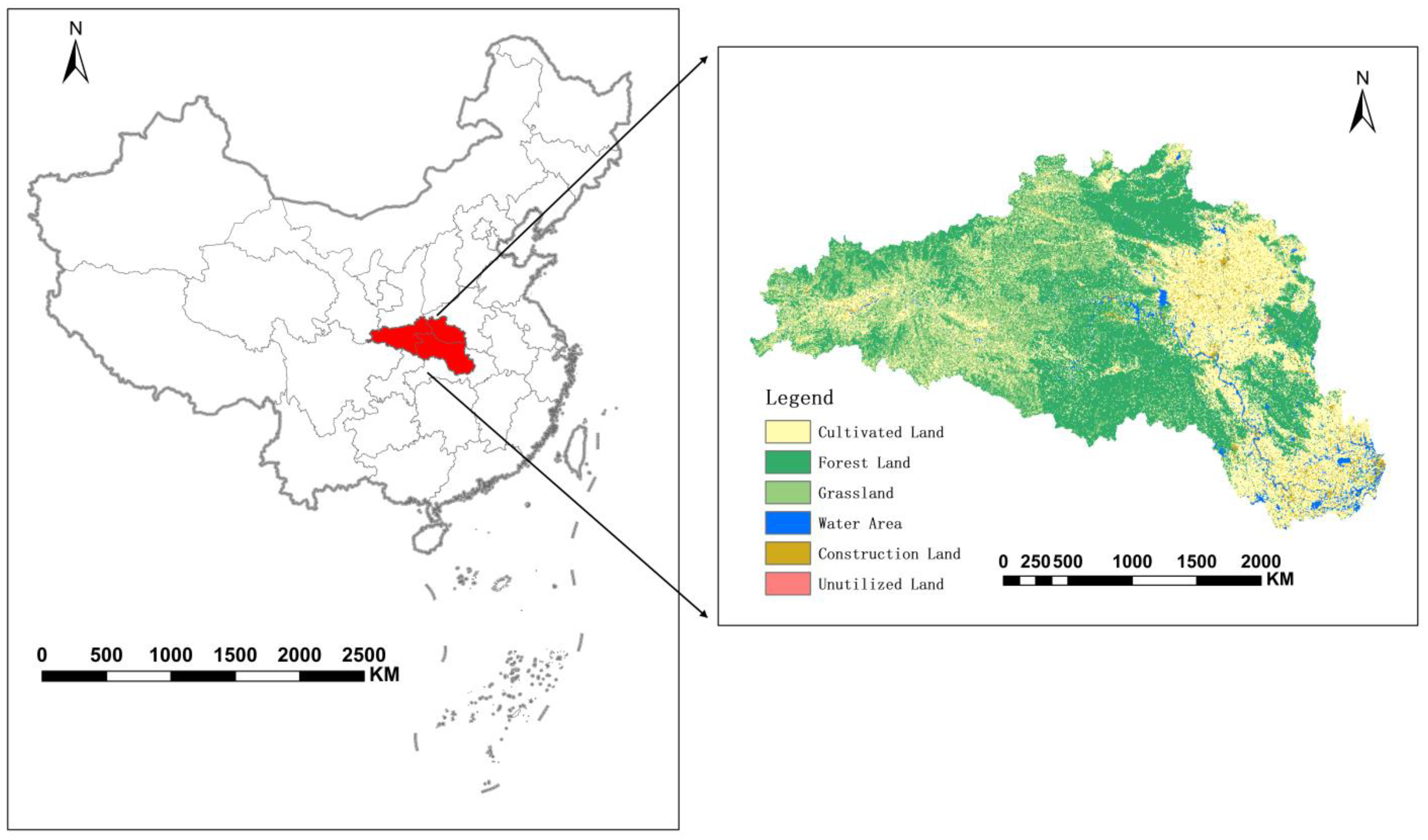
In this study, software platforms such as ArcGIS, The Environment for Visualizing Images (ENVI), Guidos, and Conefor are applied to the Hanjiang Ecological Economic Zone. The MSPA method was adopted to identify and extract the core areas that are important for species migration and energy exchange. The landscape connectivity index was utilized to assess landscape connectivity within the core area, and patches in the core area with a high patch importance index were regarded as BI sources. Based on the MCR Model, it simulates the potential corridors and adopts a gravity model to identify important corridors for the purpose of constructing a potential BI network in the study area. Thus the temporal and spatial pattern variation of the BI network in the Hanjiang Ecological Economic Zone from 2010 to 2020 was explored. The research results can provide an important reference and basis for the optimization of the BI network pattern in the Hanjiang Ecological Economic Zone and provide a reference for the planning of BI network patterns in other regions.
4. Discussion
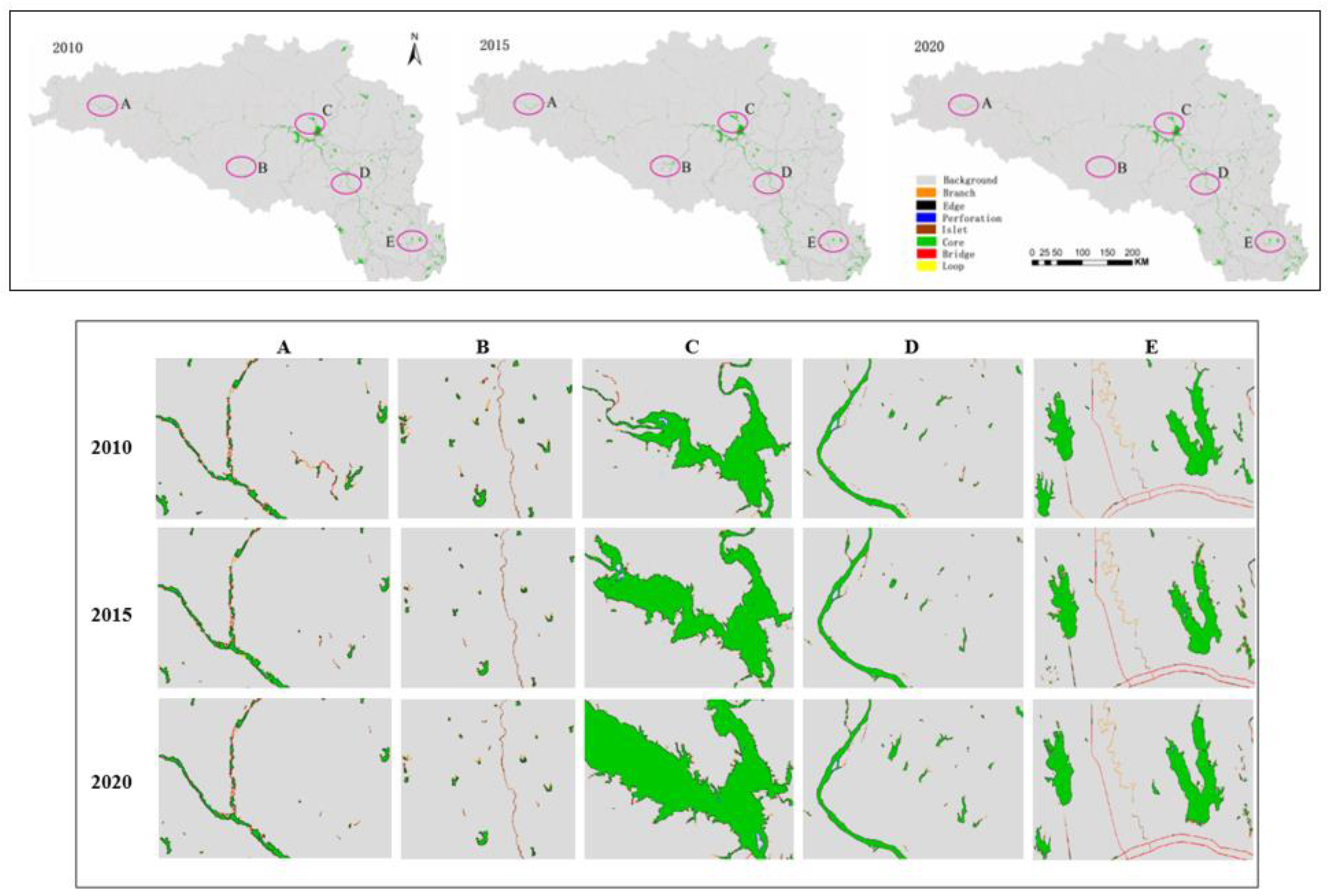
(1). The choice of research scale is important when using MSPA to analyze raster images of the landscape because the results of MSPA analysis are closely related to the variation in granularity. Therefore, it is very important to choose an appropriate analysis scale for MSPA research [
52,
53]. Different image raster sizes in the same study area will change the analysis results accordingly [
54]. For example, an increase in the image raster size of the study area may lead to the disappearance or classification of the original smaller area patches into other categories, such as small cores may be reclassified as islets, some bridges may become branches, and some branches may disappear. The Hanjiang Ecological Economic Zone is large, and a larger image raster size can cause some small patches with good connectivity to be lost or change categories types [
36,
53]. This is why the particle size at the urban scale is set to 30 m. After several tests of the threshold, this granularity can better maintain the original data characteristics, but the reasonableness of the scale still needs further study.
In addition, the edge width needs to be set during the MSPA landscape pattern analysis, and the setting of the edge width represents the size of the extent of the edge effect produced by the patches. The edge width affects the impacted range of the edge effect of the patch. For example, an extension of the edge width will result in a reduction in the core area of the landscape type and an increase in the noncore elements, so the size of the edge width has a greater impact on MSPA analysis results [
55]. The edge effect is an important concept in ecology, which is of great significance to ecological processes, species protection, and habitat protection. It must be considered in the functional planning of nature reserves [
56]. In this study, considering the area scale and data accuracy, the edge width threshold was set to 1. Since the input image raster size was 30 m × 30 m, the edge effect is 30 m. However, the edge effect is pertinent and complex. The width of the edge effect varies with different landscape properties, patch shapes, and different research objectives [
57]. As a result, the width of the edge effect set in this study is not applicable to some specific species, and the characteristics of the protected species and the nature and shape of the study area landscape also need to be considered when setting the edge effect width.
(2). For the reasons that different connectivity distance thresholds will have different impacts on the important value of patches, the betweenness centrality, and the landscape’s connectivity, it is necessary to set the connectivity distance threshold when calculating the landscape connectivity based on
PC and
IIC [
58,
59]. For example, a patch is considered connected only if the distance between patches is less than a set threshold, and the opposite is not connected. In this context, this paper determines the connectivity distance threshold by comprehensively analyzing the following factors: the condition of different distance thresholds, the changes in the area and number of patches, the number of components, and the changes in patch area in the biggest component, the area of the individual patch, and the distribution of the area of a single patch and the important value of the patch [
60]. When the connectivity distance threshold is 10,000 m, the area and number of connected patches vary greatly, and both large-area patches and small-area patches show higher important values. In addition, in order to ensure the comparability of data between years, the connectivity probability was set to 0.5. However, the setting of the connectivity distance threshold needs to take into account the dispersal distance of species, which often varies among species. Therefore, the scientific determination of this distance threshold needs more argumentation.
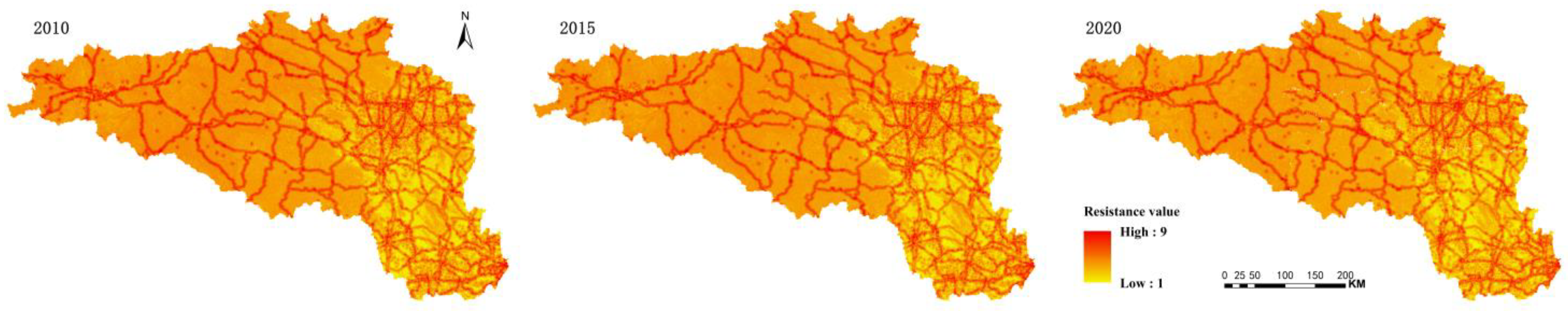
(3). MCR Model is used to simulate the potential BI corridor. The selection of resistance factors is the basis of BI network construction, and the construction of the resistance surface system is still controversial [
36], although constructing resistance surfaces by selecting resistance factors from topography, landscape types, and human activities in this paper have been reported in scientific literature. Due to the lack of detailed research data, this paper does not take the influence of the living habits of different species and the distribution of settlements and other factors on the construction of the resistance surface into consideration. In addition, the weight of resistance factors is subjective because there are no data on the relationship between species dispersal and resistance factors [
61]. It needs to be further studied and discussed in more detail in the follow-up.
(4). In the context of the implementation of the Central Line Project of South-to-North Water Diversion and the cascade reservoir project, the downstream area of Danjiangkou Reservoir shows hydrological characteristics of reduced flow and lower water level during the dry period [
62], and water quality deteriorates sharply [
42,
43]. Subsequently, with the implementation of the Yangtze River diversion to the Hanjiang and ecological restoration projects, the water quality in the Hanjiang River’s middle and lower reaches has transitioned from heavier pollution to moderate pollution and shows a trend of continuing improvement [
63]. This is consistent with the results of this study. From 2010 to 2015, the total BI area and core area decreased, the landscape connectivity decreased, and the BI network was simplified. From 2015 to 2020, the total BI area and core area increased, the landscape connectivity improved, and the BI network tended to be complex. This indicates that the study on the change of BI network pattern integrating MSPA, Landscape Connectivity Index,
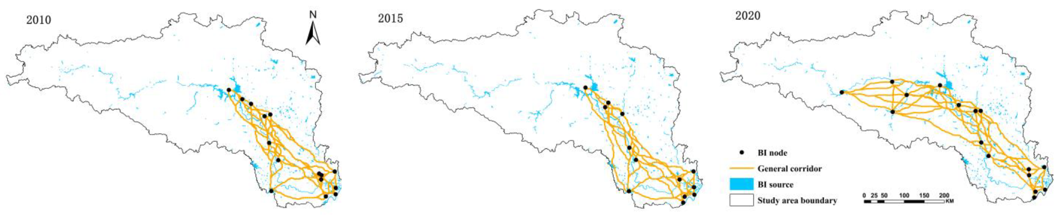
MCR model, and gravity model can reflect the hydrological characteristics and landscape pattern of water bodies in the study area from the macroscopic perspective. The research results can provide a reference for BI network planning in the study area and provide a reference for the planning of BI network patterns in other regions.
5. Conclusions
A study of the Hanjiang Ecological Economic Zone was undertaken in order to explore the temporal and spatial variation of the BI Network Pattern from 2010 to 2020. This study constructed a BI network involving three periods of time by means of the MSPA method and MCR model from the perspective of the identification of BI source, the evaluation of landscape connectivity, and BI corridor simulation. The following conclusions are achieved.
(1). In accordance with the MSPA method, the structural types that are essential to the landscape connectivity, such as the core and the bridge, are identified from the pixel level. The analysis of the temporal and spatial variation of the BI network pattern shows that the total area of BI first decreased and then increased. The change was especially obvious in the Hanjiang River’s middle and lower reaches. The patch area in the core area continually shrinks, and the degree of landscape fragmentation became more and more serious from 2010 to 2015. The patch area in the core has been repaired and expanded, and the degree of landscape fragmentation has gradually decreased since 2015. This is mainly a result of the compensation project after the Central Line Project of the South-to-North Water Diversion Project was carried out, and comprehensive governance of water resources in the Hanjiang Ecological Economic Zone occurred during this period.
(2). Based on the IIC and PC of the landscape index, the integral connectivity level of the core patches in the Hanjiang Ecological Economic Zone was quantitatively estimated. The results show that the integral connectivity of the landscape decreased from 2010 to 2015 with the increase in the degree of landscape fragmentation. The condition has improved since 2015. The integral connectivity level and possible connectivity level of the landscape display an increasing trend, and the growth rate also speeds up. However, the integral level of connectivity remains low, which is related to fewer BI sources serving as a stepping-stone and the rapid expansion of urban space.
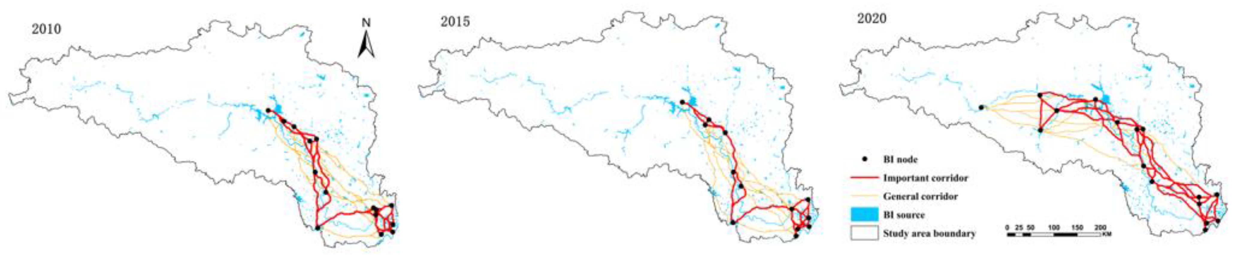
(3). In virtue of such resistance factors as natural conditions and human activities, the ecological resistance surface is constructed. Comprehensive resistance gradually increases from east to west. The potential BI corridors were generated by means of the MCR model. They are centered in the Hanjiang River’s middle and lower reaches and are expanding to the upstream area. The important corridors and patches are identified by calculating the interaction force value between BI sources based on the gravity model, and a BI network is constructed. BI network structure is quantitatively evaluated by way of network closure index, degree index, and network connectivity index. The results reveal that the network structure is simple first and then complex, which is in line with the change in the number of BI source patches. It means that the changes in the number and area of BI sources are directly related to the change in the BI network pattern.
This paper reveals the spatial and temporal evolution characteristics of the BI network pattern in the Hanjiang Ecological Economic Zone during 2010–2020, which can provide references for optimizing the BI network and formulating BI protection policies in the study area. However, there are some limitations to this study. Firstly, when adopting MSPA and landscape connectivity analysis, the thresholds have a large impact on the analysis results, and the scientific setting of thresholds still needs further exploration. In future studies, characteristics of species and study areas should be considered to determine the thresholds in an integrated manner. Secondly, although this paper provides a basic framework for resistance surface construction, it still needs to be optimized. The selection of resistance factors is not comprehensive enough, and the weight of resistance factors is also subjective. Under the condition that the relevant data are available, the resistance factors should be included, and the species dispersal characteristics should be considered to establish a more suitable resistance surface system. Lastly, there is no comprehensive analysis of the ecological network of the study area by combining other land-use types. Moving forward, green infrastructure such as forest, grassland, and cultivated land should be included in the construction of a regional ecological network in order to provide comprehensive support for urban ecological development. In the future, our team will conduct follow-up research considering the above aspects.


