
Hydrogeochemistry and Isotope Hydrology of Surface Water and Groundwater in the Mountain Watersheds of Daqing River, North China

Abstract
:1. Introduction
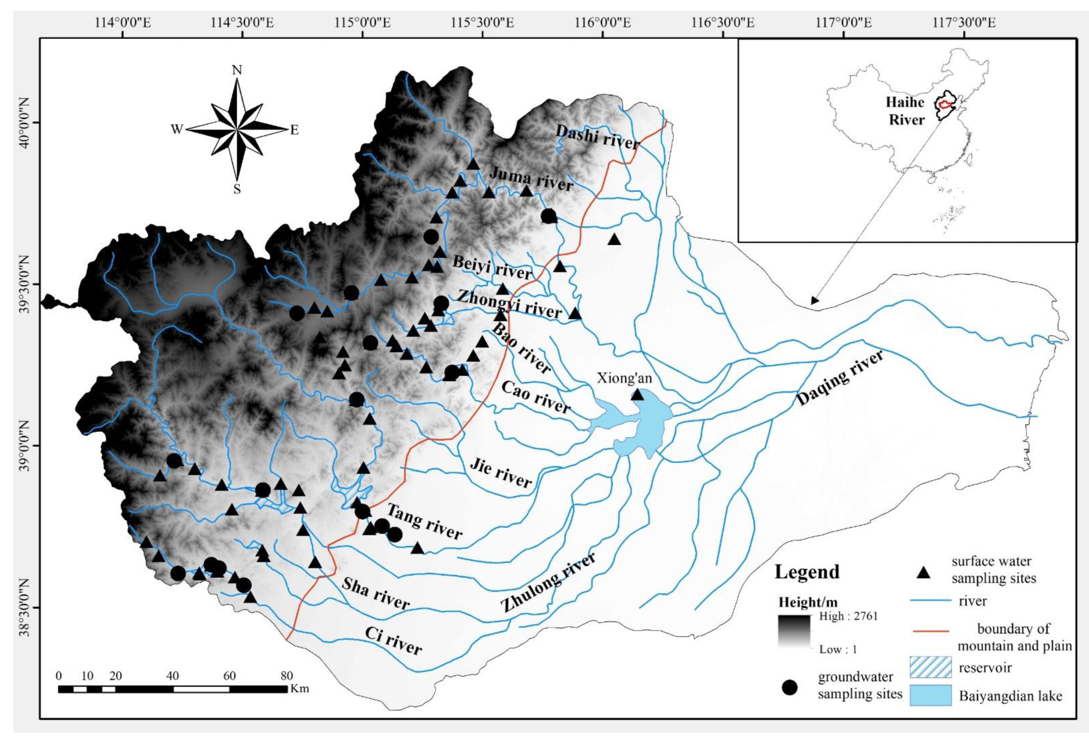
2. Study Area
3. Methodology
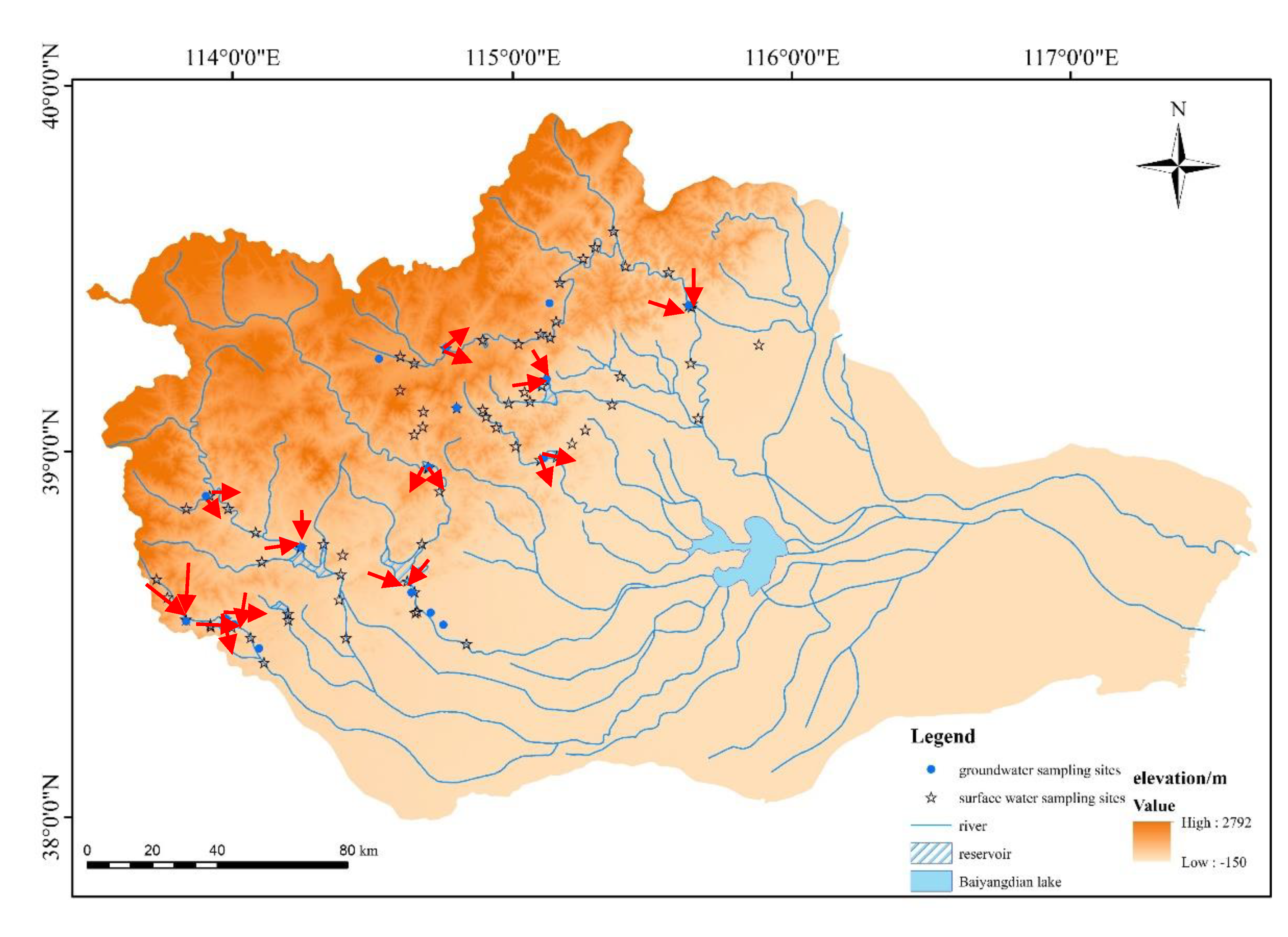
3.1. Sampling
3.2. Laboratory Work
3.3. Transformation Relationship between Surface Water and Groundwater
4. Results and Analysis
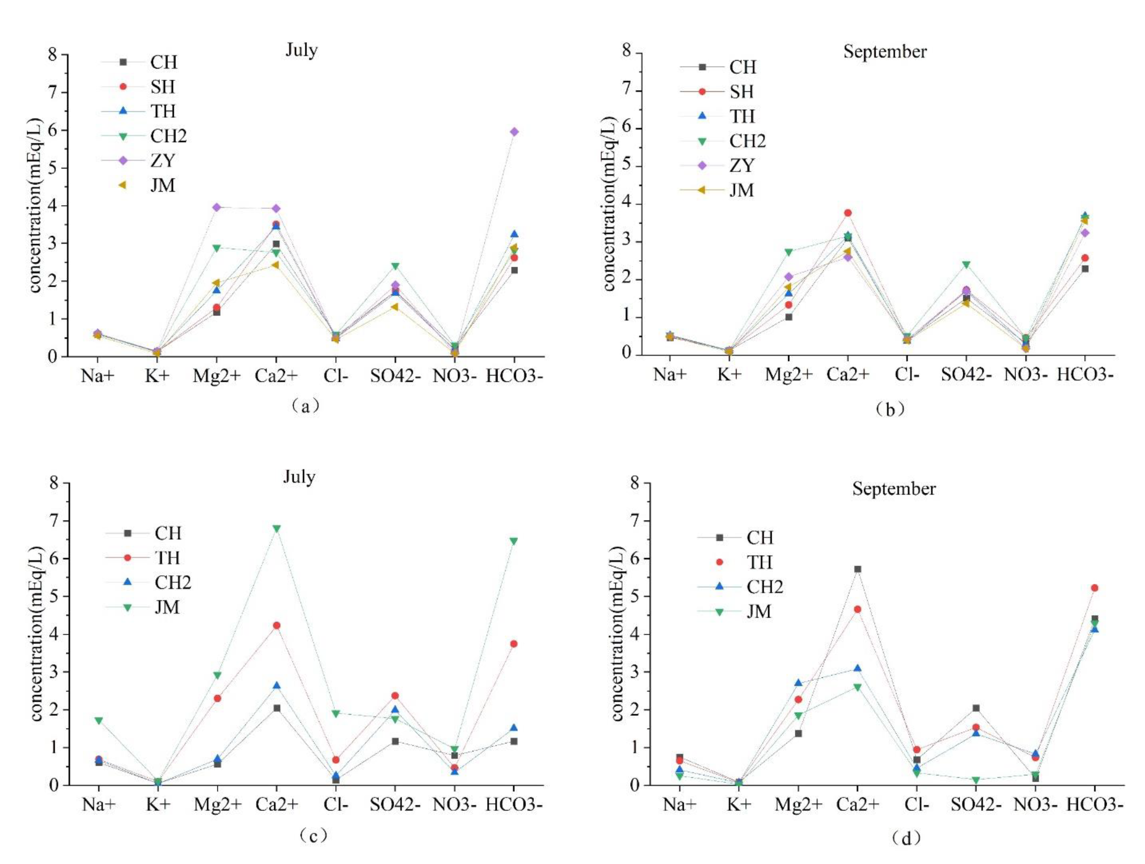
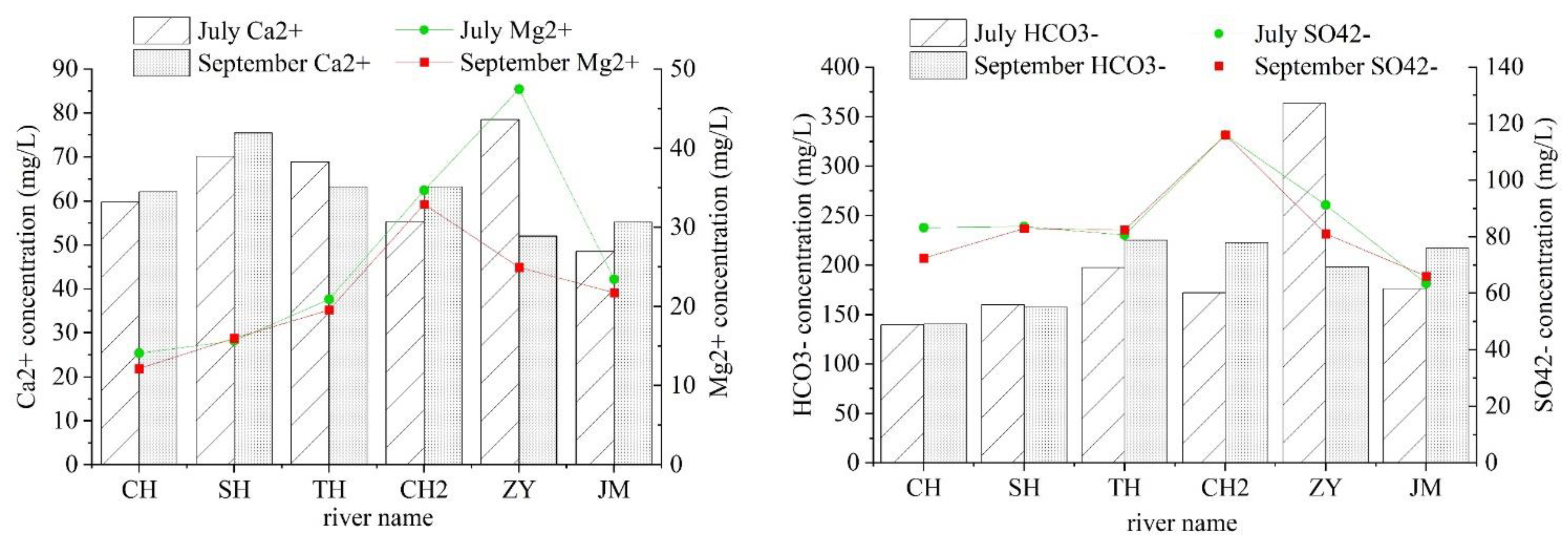
4.1. Analysis of Hydrochemical Characteristics
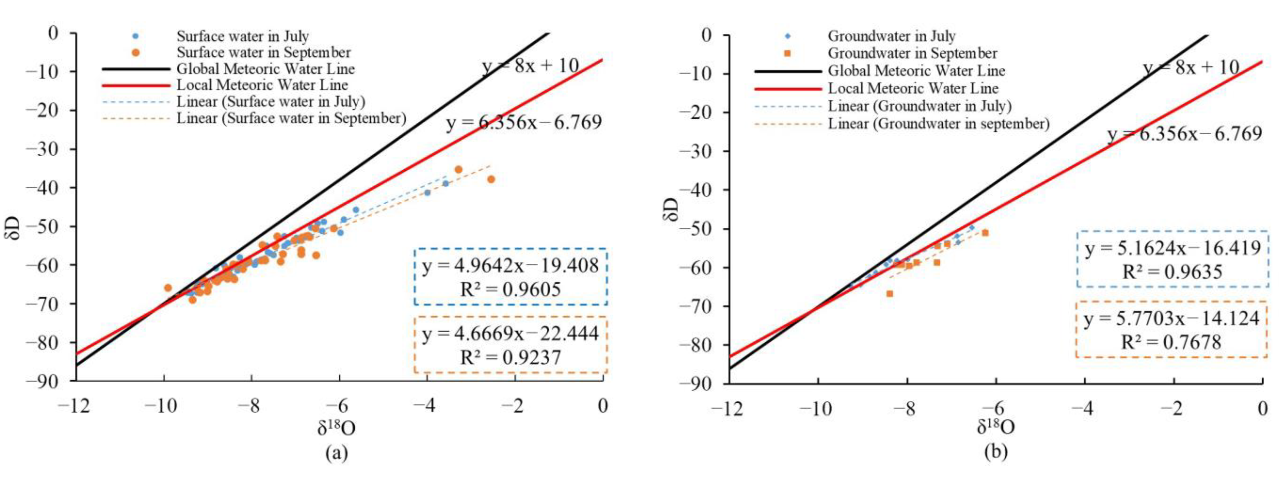
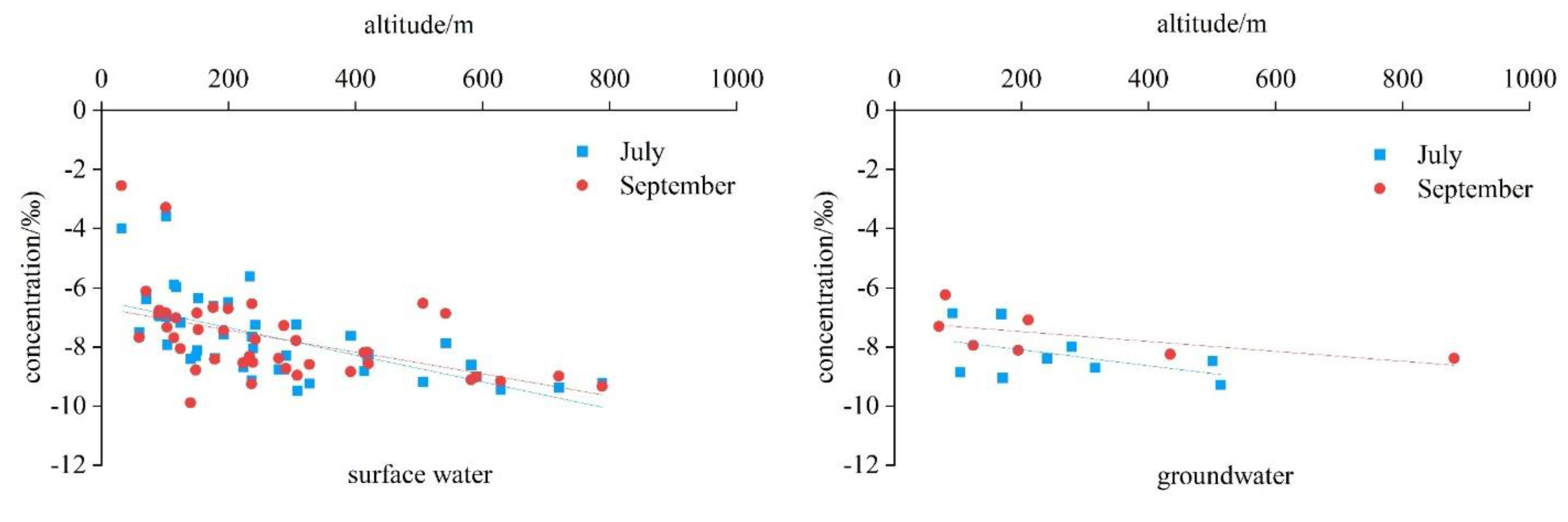
4.2. Isotopic Characteristic
5. Discussion
5.1. Isotopes and Chemical Characteristics of Water
5.2. Correlation between Isotopic Composition and Hydrochemical
5.3. Transformation Relationship between Surface Water and Groundwater
6. Conclusions
Author Contributions
Funding
Institutional Review Board Statement
Informed Consent Statement
Data Availability Statement
Conflicts of Interest
References
- Hynes, H.B.N. The Ecology of Running Waters. Ecology 1970, 52, 731–732. [Google Scholar]
- Ellen, W. Mountain Rivers; American Geophysical Union: Washington, DC, USA, 2000. [Google Scholar]
- Sophocleous, M. Interactions between groundwater and surface water: The state of the science. Hydrogeol. J. 2002, 10, 52–67. [Google Scholar] [CrossRef]
- Woessner, W.W. Stream and fluvial plain groundwater interactions. Ground Water 2000, 38, 423–429. [Google Scholar] [CrossRef]
- Edlund, M.; Almendinger, J.; Fang, X.; Hobbs, J.; VanderMeulen, D.; Key, R.; Engstrom, D. Effects of climate change on lake thermal structure and biotic response in northern wilderness lakes. Water 2017, 9, 678. [Google Scholar] [CrossRef] [Green Version]
- Alexakis, D.E.; Kiskira, K.; Gamvroula, D.; Emmanouil, C.; Psomopoulos, C.S. Evaluating toxic element contamination sources in groundwater bodies of two Mediterranean sites. Environ. Sci. Pollut. Res. 2021, 28, 34400–34409. [Google Scholar] [CrossRef] [PubMed]
- Gamvroula, D.; Alexakis, D.; Stamatis, G. Diagnosis of groundwater quality and assessment of contamination sources in the Megara basin (Attica, Greece). Arab. J. Geosci. 2012, 6, 2367–2381. [Google Scholar] [CrossRef]
- Alexakis, D.E. Meta-evaluation of water quality indices application into groundwater resources. Water 2020, 12, 1890. [Google Scholar] [CrossRef]
- Gad, M.; Saleh, A.H.; Hussein, H.; Farouk, M.; Elsayed, S. Appraisal of surface water quality of nile river using water quality indices, spectral signature and multivariate modeling. Water 2022, 14, 1131. [Google Scholar] [CrossRef]
- Wang, W.K.; Li, J.T.; Wang, Z.; Feng, X.Z.; Xu, M.; Wang, W.M.; Yang, L.J. Evolution of the Relationship between River and Groundwater and Several Scientific Problems. J. Jilin Univ. (Earth Sci. Ed.) 2007, 2, 231–238, (In Chinese with English Abstract). [Google Scholar]
- Song, X.F.; Liu, X.C.; Xia, J.; Yu, J.J.; Tang, C.Y. Research on the transformation relationship between surface water and groundwater in the Huaisha River basin based on environmental isotope technology. Sci. China 2007, 37, 102–110, (In Chinese with English Abstract). [Google Scholar]
- Zhang, B.; Song, X.F.; Zhang, Y.H.; Han, D.M.; Yang, L.H.; Tang, C.Y. Relationship between surface water and groundwater in the second Songhua River basin. Adv. Water Sci. 2014, 25, 336–347, (In Chinese with English Abstract). [Google Scholar]
- Cook, P.G.; Favreau, G.; Dighton, J.C.; Tickell, S. Determining natural groundwater influx to a tropical river using radon, chlorofluorocarbons and ionic environmental tracers. J. Hydrol. 2003, 277, 74–88. [Google Scholar] [CrossRef]
- Song, X.F.; Liu, X.; Xia, J.; Zhang, X.C.; Yu, J.J.; Zhang, Y.H. Interactions Between Surface Water and Groundwater in Chabagou Catchment Using Hydrogen and Oxygen lsotopes. J. Basic Sci. Eng. 2009, 17, 8–20, (In Chinese with English Abstract). [Google Scholar]
- Zhang, Y.H.; Wu, Y.Q.; Wen, X.H.; Su, J.P. Application of environmental isotopes in water cycle. Adv. Water Sci. 2006, 17, 738–747, (In Chinese with English Abstract). [Google Scholar]
- Bajracharya, R.; Nakamura, T.; Ghimire, S.; Man Shakya, B.; Kazi Tamrakar, N. Identifying Groundwater and River Water Interconnections Using Hydrochemistry, Stable Isotopes, and Statistical Methods in Hanumante River, Kathmandu Valley, Central Nepal. Water 2020, 12, 1524. [Google Scholar] [CrossRef]
- Mahlangu, S.; Lorentz, S.; Diamond, R.; Dippenaar, M. Surface water-groundwater interaction using tritium and stable water isotopes: A case study of Middelburg, South Africa. J. Afr. Earth Sci. 2020, 171, 103886. [Google Scholar] [CrossRef]
- Hao, S.; Li, F.D.; Li, Y.H.; Qiao, Y.F.; Zhu, N.; Fu, K. Transformation Between Surface Water and Groundwater in Ebinur Lake Basin Based on Hydrogen and Oxygen Stable lsotopes. J. Soil Water Conserv. 2021, 35, 172–185, (In Chinese with English Abstract). [Google Scholar]
- Xia, J. A Perspective on Hydrological Base of Water Security Problem and its Application Study in North China. Prog. Geogr. 2002, 6, 517–526, (In Chinese with English Abstract). [Google Scholar]
- Zhou, G.F.; Xie, W.J. Study on Meteorological Drought and Water Resource Situation of the Haihe River Basinin the Last 20 Years. Land Resour. Inf. 2021, 1–5, (In Chinese with English Abstract). Available online: https://web02.cnki.net/kmobile/Journal/detail/DKCJ/GTZQ20211020000 (accessed on 20 March 2022).
- Yao, P.; Lu, G. Hydrochemical and isotopic characteristics of the Juma River and their implications. Environ. Sci. 2017, 36, 1525–1536, (In Chinese with English Abstract). [Google Scholar]
- Chen, Y. Pore-Water and Groundwater Hydrochemical Characteristics and Hydrogeochemical Processes in Baiyangdian Lake Basin; China University of Geosciences: Beijing, China, 2018. [Google Scholar]
- Yuan, R.Q.; Song, X.F.; Wang, P.; Zhang, Y.H.; Wang, S.Q.; Tang, C.Y. Impacts of percolation in Baiyangdian Lake on groundwater. Adv. Water Sci. 2012, 23, 751–756, (In Chinese with English Abstract). [Google Scholar]
- Sun, C.J.; Chen, W. Relationship Between Groundwater and Surface Water Based on Environmental Isotope and Hydrochemistry in Upperstream of the Haihe River basin. Sci. Geogr. Sin. 2018, 3, 790–799. [Google Scholar]
- Yang, R.X.; Hou, B.D.; Lu, F.; Liang, C.; Zhao, Y.; Xiao, W.H. Preliminary analysis and promotion of water resources carrying capacity for Xiong’an New Area. Water Resour. Hydropower Eng. 2019, 50, 19, (In Chinese with English Abstract). [Google Scholar]
- Sakakibara, K.; Tsujimura, M.; Song, X.F.; Zhang, J. Spatiotemporal variation of the surface water effect on the groundwater recharge in a low-precipitation region: Application of the multi-tracer approach to the Taihang Mountains, North China. J. Hydrol. 2017, 545, 132–144. [Google Scholar] [CrossRef]
- Liu, Y.Y. Evolution Analysis and Health Assessment of Baiyangdian Wetland Ecosystem; Hebei Agricultural University: Hebei, China, 2019. [Google Scholar]
- Yuan, X.M.; Liu, Q.; Ma, X.J.; Sun, Y.S.; Yan, S.R.; Li, M. Hydrochemical Characteristics and Possible Controls of the Surface Water in Baiyangdian lake basin. Environ. Eng. 2020, 38, 1–6, (In Chinese with English Abstract). [Google Scholar]
- Yang, H.; Cao, J.S. Analysis of basin morphologic characteristics and their influence on the water yield of mountain watersheds upstream of the Xiong’an New Area, North China. Water 2021, 13, 2903. [Google Scholar] [CrossRef]
- Clark, I.D.; Fritz, P. Environmental Isotopes in Hydrogeology, 2nd ed.; Taylor and Francis: Abingdon, UK; Chemical Rubber Company Press: Boca Raton, FL, USA, 1997. [Google Scholar]
- Aiken, G.R.; Achim, A.; Amundson, R.G.; Luis, A.A.; Aravena, R.O. Isotope Tracers in Catchment Hydrology; Elsevier BeslotenVennootschap: Amsterdam, The Netherlands, 1998. [Google Scholar]
- Katherine, W.D.; Eileen, P. Investigating hydraulic connections and the origin of water in a mine tunnel using stable isotopes and hydrographs. Appl. Geochem. 2009, 24, 2266–2282. [Google Scholar]
- Dansgaard, W. Stable isotope in precipitation. Tellns 1964, 16, 436–468. [Google Scholar]
- Allison, G.B. The relationship between 180 and deuterium in water in sand columns undergoing evaporation. J. Hydrol. 1982, 55, 163–169. [Google Scholar] [CrossRef]
- Joussaume, S.; Sadourny, R.; Jouzel, J. A general circulation model of water isotope cycles in the atmosphere. Nature 1984, 311, 24–29. [Google Scholar] [CrossRef]
- Siegenthaler, U.; Oeschge, R.H. Correlation of 18O in precipitation with temperature and altitude. Nature 1980, 285, 314–317. [Google Scholar] [CrossRef]
- Araguas, L.; Froe hlich, K.; Rozanski, K. Stable isotope composition of precipitation over Southeast Asia. J. Geophys. Res. (Atmos.) 1998, 103, 28721–28742. [Google Scholar] [CrossRef]
- Ma, J.Z.; Zhang, P.; Zhu, G.F.; Wang, Y.Q.; Edmunds, W.M.; Ding, Z.Y.; He, J.H. The composition and distribution of chemicals and isotopes in precipitation in the Shiyang River system, northwestern China. J. Hydrol. 2012, 436, 92–101. [Google Scholar] [CrossRef]
- Guo, X.Y.; Feng, Q.; Wei, Y.P.; Li, Z.X.; Liu, W. An overview of precipitation isotopes over the extensive Hexi Region in NW China. Arab. J. Geosci. 2015, 8, 4365–4378. [Google Scholar] [CrossRef] [Green Version]
- Zhang, P. Hydrogen-Oxygen Isotope Geochemistry and Environmental Indication of River Water in the Dabieshan Area, the Upper Watershed of Huaihe River, China; China University of Geosciences: Beijing, China, 2019. [Google Scholar]
- Ma, X.G.; Jia, W.X.; Zhu, G.F.; Ding, D.; Pan, H.X.; Xu, X.T.; Guo, H.W.; Zhang, Y.; Yuan, R.F. Stable isotope composition of precipitation at different elevations in the monsoon marginal zone. Quat. Int. 2018, 493, 86–95. [Google Scholar]
- Kallbus, E.; Reinstorf, F.; Schirmer, M. Measuring methods for groundwater-surface water interactions: A review. Hydrol. Earth Syst. Sci. 2006, 3, 873–887. [Google Scholar] [CrossRef] [Green Version]
- Ochoa, C.G.; Sierra, A.M.; Vives, L.; Zimmermann, E.; Bailey, R. Spatio-temporal patterns of the interaction between groundwater and surface water in plains. Hydrol. Processes 2020, 34, 1371–1392. [Google Scholar] [CrossRef]


| Year | Water Type | Number | Isotope | Ca2+ | K+ | Mg2+ | Na+ | Cl− | SO42− | NO3− | HCO3− |
|---|---|---|---|---|---|---|---|---|---|---|---|
| 201809 | surface water | 42 | 18O | −0.317 * | 0.325 * | −0.014 | 0.351 * | 0.342 * | −0.02 | −0.166 | −0.223 |
| D | −0.273 | 0.370 * | −0.087 | 0.373 * | 0.380 * | 0.854 | 0.499 | 0.039 | |||
| groundwater | 5 | 18O | 0.867 | 0.767 | 0.049 | 0.934 * | 0.980 ** | 0.799 | 0.153 | 0.811 | |
| D | 0.872 | 0.889 * | 0.05 | 0.934 * | 0.873 | 0.900 * | 0.276 | 0.716 | |||
| 201907 | surface water | 42 | 18O | −0.384 * | 0.08 | 0.016 | 0.233 | 0.323 * | −0.036 | −0.073 | −0.269 |
| D | −0.333 * | 0.164 | −0.043 | 0.216 | 0.326 * | −0.001 | −0.001 | −0.288 | |||
| groundwater | 5 | 18O | 0.166 | 0.655 | 0.441 | −0.103 | 0.16 | 0.094 | −0.177 | 0.303 | |
| D | 0.199 | 0.628 | 0.45 | −0.015 | 0.208 | −0.031 | 0.065 | 0.332 |
Publisher’s Note: MDPI stays neutral with regard to jurisdictional claims in published maps and institutional affiliations. |
© 2022 by the authors. Licensee MDPI, Basel, Switzerland. This article is an open access article distributed under the terms and conditions of the Creative Commons Attribution (CC BY) license (https://creativecommons.org/licenses/by/4.0/).
Share and Cite
Zhao, Y.; Yang, H.; Cao, J. Hydrogeochemistry and Isotope Hydrology of Surface Water and Groundwater in the Mountain Watersheds of Daqing River, North China. Water 2022, 14, 1451. https://doi.org/10.3390/w14091451
Zhao Y, Yang H, Cao J. Hydrogeochemistry and Isotope Hydrology of Surface Water and Groundwater in the Mountain Watersheds of Daqing River, North China. Water. 2022; 14(9):1451. https://doi.org/10.3390/w14091451
Chicago/Turabian StyleZhao, Yuhan, Hui Yang, and Jiansheng Cao. 2022. "Hydrogeochemistry and Isotope Hydrology of Surface Water and Groundwater in the Mountain Watersheds of Daqing River, North China" Water 14, no. 9: 1451. https://doi.org/10.3390/w14091451
APA StyleZhao, Y., Yang, H., & Cao, J. (2022). Hydrogeochemistry and Isotope Hydrology of Surface Water and Groundwater in the Mountain Watersheds of Daqing River, North China. Water, 14(9), 1451. https://doi.org/10.3390/w14091451