Water 2022, 14(9), 1417; https://doi.org/10.3390/w14091417 - 29 Apr 2022
Cited by 17 | Viewed by 3784
Abstract
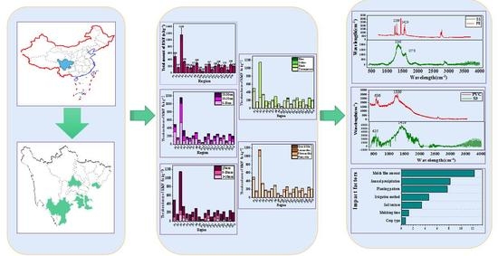
With the continuous increase in the amount of mulch film, “white pollution” caused by plastic fragments (PF) has seriously affected agricultural production progress and poses a great threat to the safety and health of the agricultural environment. In the present study, PFs collected
[...] Read more.
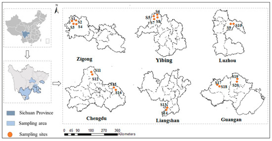
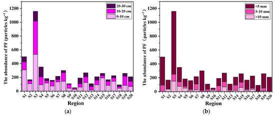
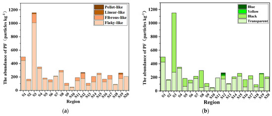
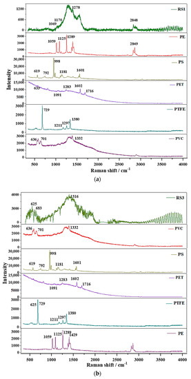
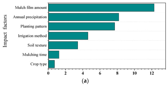
With the continuous increase in the amount of mulch film, “white pollution” caused by plastic fragments (PF) has seriously affected agricultural production progress and poses a great threat to the safety and health of the agricultural environment. In the present study, PFs collected from 20 mulched agricultural farmlands in Sichuan Province were investigated. The PFs were separated and screened following the density flotation method. Optical microscopy was used to assess the fragments’ distribution, abundance, color, size, and morphology, and Raman spectroscopy was used to identify the types. In addition, through the analysis of a questionnaire survey, a random forest (RF) model was conducted to assess the effects of environmental factors on the amount of PF. The results showed that the abundance of PFs was the highest in Lade Town, Zigong City, reaching 1158.33 ± 52.04 particles kg−1. Meanwhile, PFs were less abundant in Foyin Town, Luzhou City, with 50.00 ± 25.00 particles kg−1; the morphology features of PF in the cultivated soil were mainly transparent (60.06%) and flaky-like (83.41%), with sizes < 5 mm (63.61%). In total, 75% of the representative PFs were PE PFs, while PVC PFs were 25%. The RF model indicated that there were significant effects due to the total mulch film amount, annual precipitation, and planting pattern on the number of derived residues (PF). This study provides data indicating the urgent need to prevent and control plastic pollution in mulch farming, specifically in the soils of Sichuan Province.
Full article
(This article belongs to the Special Issue Microplastics Pollution and Solutions)
►
Show Figures
Graphical abstract


