Abstract
The Weihe Basin is a crucial part of the Fenwei Graben System and is a typical example of an extensional fault basin. Over time, the region has been developed around 212 ground fissures, with the majority of them being associated with heavy rainfall. These water-eroded ground fissures have caused serious damage to farmland, houses, and roads, with the Liangjiacun ground fissures, Meiyuancun ground fissures, and Dizhentai ground fissures being the most known. To understand the developmental characteristics and formation mechanisms of water-eroded ground fissures in the Weihe Basin, we utilized a variety of methods, including ground surveys, mapping, trenching, drilling, and geophysical exploration. These three ground fissures are distributed along corresponding fault zones, with their orientations being closely linked to local topographic changes. Additionally, the trenching profiles showed that all three typical ground fissure zones have distinct hidden holes above the paleosol. The formation of these ground fissures is closely associated with tectonic activity and heavy rainfall, with soil ruptures resulting from tectonic activity becoming the dominant channels for surface water infiltration. Furthermore, the erosion caused by heavy rainfall accelerates the rupture and expansion of ground fissures in the shallow subsurface. This paper is a valuable resource for disaster prevention and mitigation strategies aimed at mitigating the damage caused by ground fissures in the Weihe Basin.
1. Introduction
Ground fissures are surface breaks in rocks or soil caused by dynamic geological forces both within and outside the earth’s surface [1,2]. Ground fissures can result from a multitude of factors, including regional stress fields, fault structures, groundwater extraction, and rainfall. These factors give rise to ground fissures that are distributed worldwide in varying sizes and levels of severity [3,4,5,6,7,8,9,10]. Depending on the controlling factors, ground fissures can be classified as either tectonic or nontectonic. Tectonic fissures are a geological hazard resulting from tectonic forces and are typically closely associated with fault activity [11]. Numerous publications from diverse countries and regions have addressed and investigated tectonic fissures that are controlled by faults [2,11,12,13,14,15,16]. Tectonic fissures are often linked to endogenic geological processes, with crustal extension and differential block movement being crucial factors in their formation [13,16]. This phenomenon is commonly observed in areas with high tectonic activity, such as rifts and basins. For example, the most severe fissure disasters in China have occurred in the Fenwei Basin [17], and in Ethiopia, the Great Rift Valley is a prime example of such an area [13]. As human activities become more frequent, including mining and water pumping, geological faults are developing and being exposed at an accelerated rate. For instance, the extraction of groundwater in Avenida Valley has led to ground subsidence and the emergence of ground fissures [5]. Groundwater overexploitation in central and southern Arizona, USA has led to ground subsidence and ground fissures [7]. Coal mining activities in the Mavropigi village region of northern Greece have caused ground fissures [6].
In addition, there is an increasing scholarly interest in the sudden ground fissures that are caused by heavy rainfall. Such rainfall creates multiple shallow underground fracture channels caused by surface water infiltration. In the study of surface water erosion-induced geological fissures, these studies can be classified into two types. The first type is the fissure that connects with the bedrock fracture, such as the underground erosion-induced geological cracks in the Great Rift Valley of Kenya. These fissures are formed by preferential permeability channels that are controlled by the bedrock fracture, and they go through four stages: uniform permeability, dominant permeability, cavity expansion, and collapse [18]. Another type of ground fissure is caused by erosion along shallow surface fissures, which provide dominant pathways for fluid flow due to various factors, such as seismic activity, regional tectonic movements, and the long-term drying of mud cracks [4,8,19,20]. The ground fissures in the southern region of the Indian state of Uttar Pradesh were formed as a result of a prolonged drought followed by heavy rainfall. The top layer of clay became unsaturated for a significant amount of time due to the long drought, which caused the development of mud fissures extending downward to the clay silt layer at the bottom. When surface water infiltrated, it carried away finer particles of clay, silt, and sand from below the top clay layer, leading to the development of underground cavities [8].
Over 200 ground fissures have developed in the Wei River Basin, including the Xi’an ground fissure group, Kouzhen Guanshan ground fissure zone, Wei River ground fissure zone, Sanyuan Fuping ground fissure zone, and Dali ground fissure group [1,17,20,21,22,23]. These features are generated by four factors: basin structure, active faults, human activity, and loess erosion [21]. The cause of the highly scrutinized Xi’an ground fissure can be attributed to both natural factors and human activities [24]. Most of the structural fissures are connected to hidden underground faults and exhibit synsedimentary characteristics, as exemplified by the Fuping Tingzicun and Sanyuan Shuanghuaishu faults [19,20]. These ground fissures are the result of dynamic tectonic processes, including the uplifting of the upper mantle and extension of the crust, differential block movement, and fault activity [16]. The primary cause of the formation of fissures in the Wei River basin is due to tectonic faulting; however, human activities causing a human–land imbalance have accelerated the activity of these fissures [21]. During periods of heavy rainfall, a large amount of surface water infiltrates into the hidden fissures in Shuanghuaishu in Sanyuan. This infiltration causes significant erosion and scouring of the soil inside the cracks, which has accelerated the formation of ground fissures overnight [19]. Most studies on this type of fissure, both domestic and international, have mainly focused on the development characteristics and formation mechanisms of individual fissures, and lacked mechanical analysis. There is no good summary of the formation laws of the water-eroded fissures under heavy rainfall. This study uses the fissure coexistence relationship of the Dizhentai ground fissure, Liangjiacun ground fissure, and Meiyuancun ground fissure in the Weihe Basin to reveal the coexistence mechanism and discuss it.
2. Geologic Background
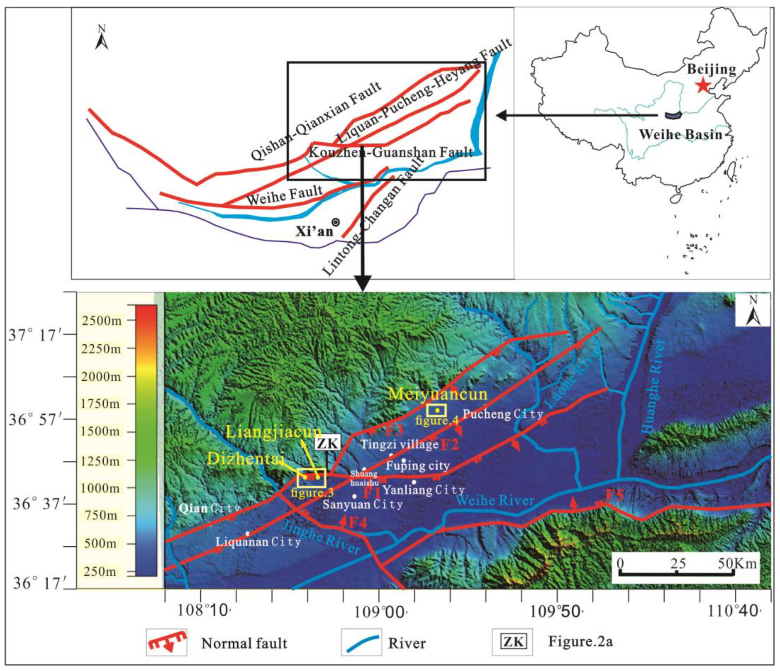
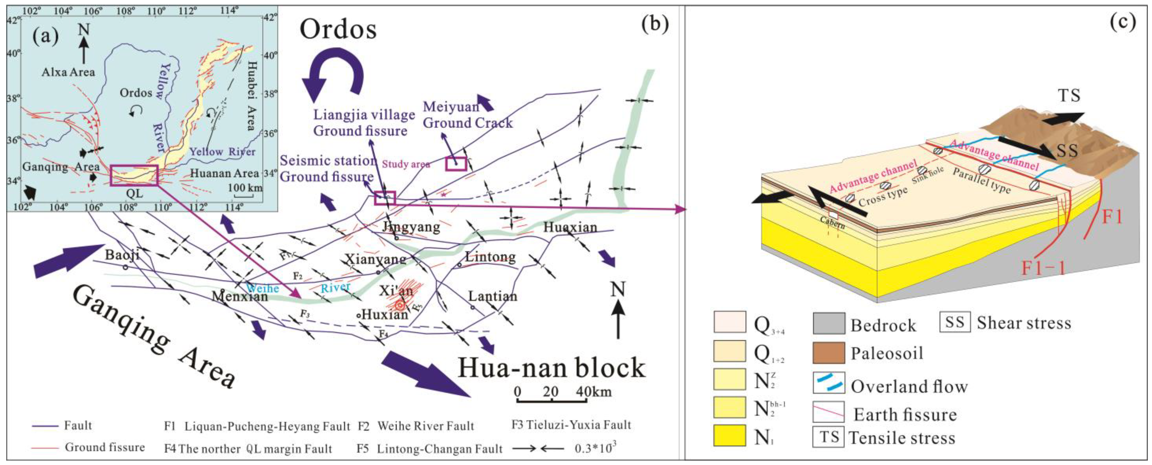
The Dizhentai ground fissures, Liangjiacun ground fissures, and Meiyuancun ground fissures are located in the northern edge of the Weihe Basin, an important part of the southern end of the Fen-Wei Basin in China. Influenced by the uplift of the Qinghai-Tibet Plateau, the eastward squeezing of the Gansu–Qinghai block, and the leftward rotation and eastward movement of the Ordos block, the basin shows a northwest–southeast tensional environment, which strengthens the activity of the active faults in the basin and provides a structural environment for the formation of the ground fissures in the basin, including the Weihe Basin and the surrounding fault basins [25].
The study area is mainly controlled by two faults, namely the Kouzhen–Guanshan Fault (F1) and the Liquan–Pucheng–Heyang Fault (F2) (Figure 1). The Koutun–Guanshan Fault is a concealed normal fault with a total length of 150 km, trending east–west and dipping southward at an angle of 50° to 70°. The fault displacement of Quaternary strata reaches up to 200 m, and in Guanshan Town, there is a difference in thickness of 1300 m of the Neogene strata between the two sides of the fault, reflecting the characteristics of a sedimentary fault. The Liquan–Pucheng–Heyang Fault is a normal fault with an overall NE–SE trend and a dip angle of 40° to 60°, with a total length of 170 km.

Figure 1.
Geologic map of the Research Area: F1, Kouzhen–Guanshan Fault; F2, Liquan–Pucheng–Heyang Fault; F3, Qishan–Qianxian Fault; F4, Jinghe–Chanhe fault; F5, Weihe fault.
The study area is located in a semihumid region with an average annual precipitation of 486.3 mm. During nonrainy periods, the unsaturated soil layer in the area can promote the development of fissures [8]. Additionally, the study area is backed by the highlands of the Ordos Block, which provides a good surface water supply environment from high to low terrain (Figure 2b). Alternating loess and paleosols are present in the study area, resulting in significant differences in the vertical direction of the lithology of shallow geological strata. Malan loess is widely distributed in the study area, and is characterized as being loose, porous, calcium-rich, and having high collapsibility. Moreover, the vertical joints are relatively developed, providing a favorable geological material basis for the development and expansion of ground fissures [19,20]. The shallow soil layers of loess and paleosol alternate vertically in the study area, with distinct differences in lithology corresponding to the deposited loess and paleosol (Figure 2a). The loess has good permeability but weak erosion resistance, making it susceptible to erosion, while the paleosol has poor permeability but strong erosion resistance, making it less susceptible to erosion. These characteristics provide a structural foundation for water erosion fissures. Weak tensile strength, loose structure, and high shrink–swell potential are important contributing factors to the development of ground fissures in the loess areas of China [26].
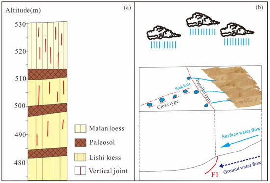
Figure 2.
Lithology and topography of the study area: (a) stratigraphic characteristics of loess and paleosol; (b) rainfall and topographical characteristics.
3. Ground Fissure Characteristics
Through the use of geological exploration techniques, including measurement, mapping, and trench excavation, the plane distribution and profile structural features of Liangjiacun ground fissures, Meiyuancun ground fissures, and Dizhentai ground fissures were analyzed. These methods provided valuable insights into the characteristics and origins of water-eroded ground fissures in the Weihe Basin.
3.1. Surveying and Mapping
The Dizhentai ground fissure is situated at the junction of the towering Cuoe Mountains and the proluvial fan in front of the mountain. The terrain slopes down gradually from north to south. This fault is about 1500 m long, and its direction ranges between 90°–100°. It is distributed intermittently in a zigzag pattern, parallel to the Kouzhen–Guanshan fault, within 100 m of the upper plate. The main fault provides an advantageous parallel-type channel (Figure 2b). The surface features of the fissure include fissures and large bead-like sinkholes, some of which are continuous along the fissure and have a significant horizontal opening without any filling material. Along the fissure zone, six sets of typical photographs have been distributed, which include three fissures (Figure 3b,c,f), tow sinkholes (Figure 3a,d), and one loess hole (Figure 3e). The fissures are relatively long with good continuity, while the loess hole has a maximum inner diameter of 27 cm with a loose soil texture, indicating that it belongs to a shallow loess hole. Due to the effect of rainfall, the maximum opening width of the fissure on the surface reaches 1 m, indicating a depth of more than 5 m.
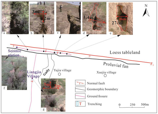
Figure 3.
Distribution of the Dizhentai ground fissure and Liangjiacun ground fissure: (a–g) typical photos.
The Liangjiacun ground fissure is located south of the Kouzhen–Guanshan margin fault, with higher elevation to the north and lower elevation to the south. The fissure is about 2000 m long, trending SE150°–SW210°, intersecting with the Kouzhen–Guanshan fault and exposed within 2 km of the upper plate of the Kouzhen–Guanshan fault. The main fissure provides an advantageous cross-type channel due to its strike-slip property (Figure 2b). The surface features of the fault include large bead-like sinkholes, which are mainly distributed within 2 km of the upper plate of the Kouzhen–Guanshan fault. The maximum surface cracking width of the fault reaches 3 m, indicating a depth of up to 5 m (Figure 3g). After heavy rainfall, the activity of the fault significantly increases, with the length, width, and depth of the cracks and sinkholes noticeably increasing.
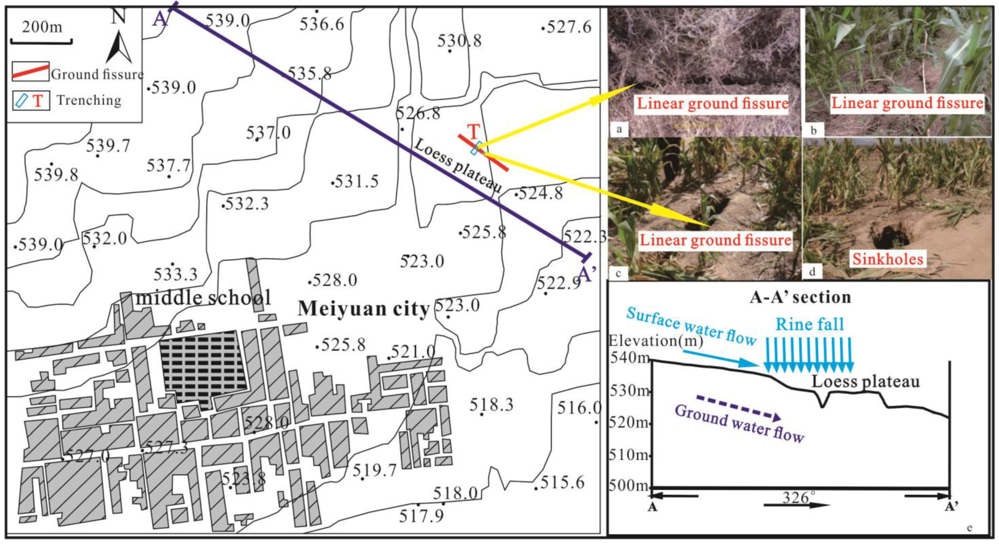
The Meiyuancun ground fissure is developed between the Qishan–Qianxian Fault (F3) and the Liquan–Pucheng–Heyang Fault (F2) (Figure 1). The fissure appeared in a cornfield in Meiyuan Town, with a length of about 200 m and a trend of NW326° (Figure 4a). According to local villagers, the fissure appeared after the Wenchuan earthquake on 12 May 2008, and was formed suddenly after heavy rain on the night of 6 June 2008. Jinlishan, about 7.5 km to the north, is a fluviatile plain with the terrain high in the northwest and low in the southeast (Figure 4e). The fissure caused surface cracking in farmland, with a maximum width of 30–40 cm, mainly developing as bead-shaped sinkholes (Figure 4d), and in some local areas, it developed in a linear shape (Figure 4a–c), but the overall size of the fissure is not large, and it extends a short distance along the trend.
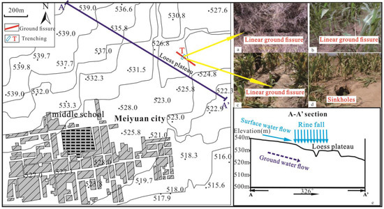
Figure 4.
Distribution and topographic map of Meiyuan ground fissure: (a–d) typical photos; (e) A-A’ section.
3.2. Trenching
In order to reveal the profile characteristics of the ground fissure, one exploratory trench was excavated, which was 20 m long, 8 m wide, and 14 m deep, at the seismic station in Kouzhen. The trench profile showed six soil layers: silt, paleosol, Malan loess, Lishi loess, silty clay, and sand gravel (Figure 5). The main fissure is nearly vertical and inclined to the north. It forms a “Y” shape with the cross-section combination of the Kouzhen–Guanshan fault. The maximum width of the surface depression is 313 cm, and the depth is about 2 m. At the bottom of the depression, two main fissures extend and have been filled with mixed soil. When the ground fissure extends downward to the first layer of paleosol layer, two cavities appear, with a maximum width of 50 cm and a maximum downward extension of 2 m, both penetrating the clay layer to the Malan loess layer (Figure 5a). The lower fissures of the cavity have been filled, and the opening amount gradually decreases downward (Figure 5b,c). There are about ten secondary fissures around the main fissure zone in the Malan loess layer, and their connectivity is good, penetrating downward to the darker-colored slope accumulation soil layer with a main lithology of gravel layer. In addition, the trench profile also revealed the displacement of the gravel layer, with a vertical displacement of 97.3 cm, indicating strong tectonic activity.
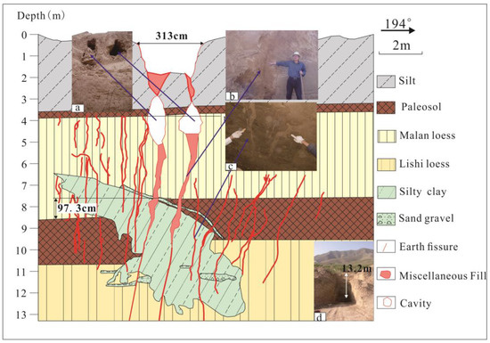
Figure 5.
Trenching of the Dizhentai ground fissure: (a) cavity photo; (b,c) typical photos; (d) Full sample of exploration groove.
In order to determine the shallow profile structural characteristics of the ground fissure, a large trench measuring 30 m long, 14 m wide and 14 m deep was excavated in Liangjiacun, Jingyang County. According to the trench profile map (Figure 6), the trench revealed the shallow structural features of the ground fissure at Liangjiacun, showing four soil layers: cultivated soil, Malan loess, paleosol, and Lishi loess. The ground fissure opens up greatly on the surface, with a width of about 1.5 m. As it extends underground, the opening decreases rapidly, and below 3 m, the crack width is only about 2 cm. The shape of the shallow part is “funnel-shaped”, with the upper part filled with mixed soil and the lower part filled with powdery clay. As the ground fissure extends downward, there is no dislocation in the stratum. When it reaches the bottom of the first paleosol layer, a cavity appears, with a width of about 1.2 m and a height of 0.8 m (Figure 6b). The upper part of the cavity is moist and has many water outlets (Figure 6d), and the bottom is covered with a layer of powdery clay about 15 cm thick (Figure 6c). An old fissure appears in the lower part, which is filled with powdery clay (Figure 6b).
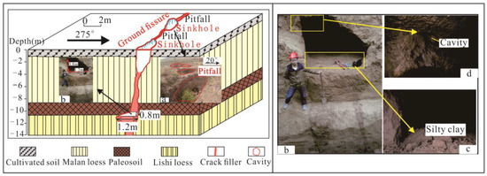
Figure 6.
Trenching of the Liangjiacun ground fissures: (a) typical photos; (b–d) cavity photo.
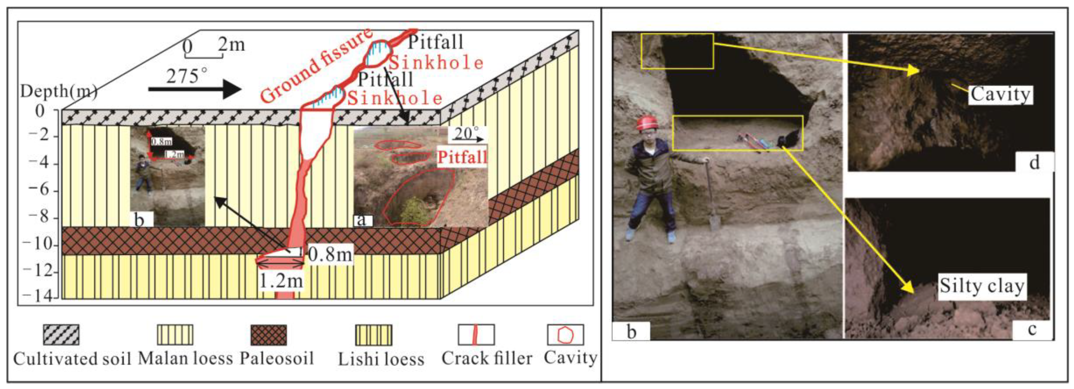
A 20 m long, 8 m wide, and 10 m deep trench was excavated in Meiyuan Town, Fuping County. According to the profile diagram of the trench (Figure 7), a total of six soil layers were exposed: cultivated soil, silty clay, Holocene loess, black loess, Malan loess, and paleosol. The profile showed that the fissure was rough, vertical, and extended downward, exhibiting tensile cracking without obvious stratigraphic dislocation. The width of the main fissure was 20–30 cm, and many small fissures developed on both sides of the main fissure. When the main fissure penetrated the first layer of clay, a cavity appeared (Figure 7a), with a maximum length of 1.2 m and a height of 15 cm. There were very few fractures (only 9) developed on the surface of the fissure above the cavity. Many small fissures developed densely on the Holocene loess and paleosol soil layers above the clay layer, with a total of 21. They were generally nearly vertical, rough, and poorly filled. This indicates that the activity of ground fissures in the area has been weak since the middle-late Holocene, and there may have been a strong regional tectonic stress field variation during the early Holocene, which caused a series of rupture deformations in the poorly plastic loess strata under extensional stress.
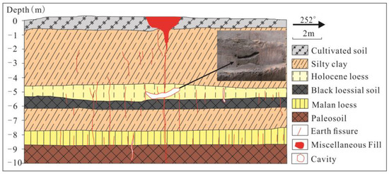
Figure 7.
Trenching of the Meiyuancun ground fissures.
4. Discussion
The ground fissures of the study area, including the Dizhentai Fissure, the Liangjiacun Fissure, and the Meiyuancun Fissure, are important components of the unique shallow water-eroded fissures in the Weihe Basin. The tectonic stress provides the initial driving force for the shallow joint fissures in loose layers. These joint fissures provide advantageous channels for both vertical surface water infiltration and lateral groundwater flow. The alternating layers of loess and paleosol provide a good geological material foundation for groundwater erosion. The terrain of higher elevation in the north and lower elevation in the south provides potential energy for groundwater.
4.1. Tectonic Formation Mechanism
The study area’s ground fissures are located in the north of the Weihe Basin, which is situated at the southern end of the Fen-Wei Graben in China (Figure 8a). The Weihe Basin is located to the east of the Gansu–Qinghai Block, to the west of the South China Block, and to the south of the Ordos Plateau. The modern tectonic activity is intense, and the entire basin is in the NNW–SSE tensional stress field (Figure 8b).
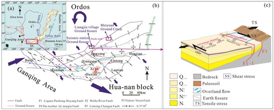
Figure 8.
Relationship between regional structure and ground fissures in the Weihe Basin: (a) Tectonic activity map of Fenwei Basin; (b) Tectonic activity map of Weihe Basin [19] (according to Peng et al., 2018); (c) Relationship between ground fractures and tectonic activity.
The direction of the Dizhentai ground fissures is consistent with that of the Kou Town–Guanshan fault, belonging to the parallel type. The development of this ground fissure is closely related to the Kou Town–Guanshan fault, and belongs to the “basin-edge fault-controlled” model dominated by the underlying Kou Town–Guanshan fault (Figure 8c). Under the action of the regional NNW–SSE extensional stress field in the Weihe Basin (Figure 8b), the activity of the edge faults causes the hanging wall to drop, forming a tensile stress zone parallel to the fault at a certain distance, and due to the low tensile strength of the loess, joint fissures are easily formed. The relationship between Liangjiacun fissures and faults is a crossing pattern (Figure 8c). They are affected by the right-lateral shearing of the northern front of the basin, which has formed a series of NNW–SSE tensional joints on the hanging wall of the front fault (Figure 8c). These joints are connected with the front fault. The Meiyuancun ground fissure is located between two faults, the Qishan–Qianxian fault (F3) and the Liquan–Pucheng–Heyang fault (F2) (Figure 1). It initially ruptured due to NNW–SSE regional tensional stress (Figure 8b), and under the influence of earthquakes, the initial rupture in the loess intensified and evolved into a near-surface weak structural plane, but its size is relatively small.
The above study areas are in different tectonic environments, including the “basin-edge faulting” mode parallel to faults, the shear-tension mode crossing faults, and the expansion mode under earthquake effects. Although the study areas are in different tectonic environments, the corresponding modes all provide the initial power for the generation of shallow fractures in loose layers. These fractures provide advantageous channels for permeation.
4.2. Hydrodynamic Extension Mechanism
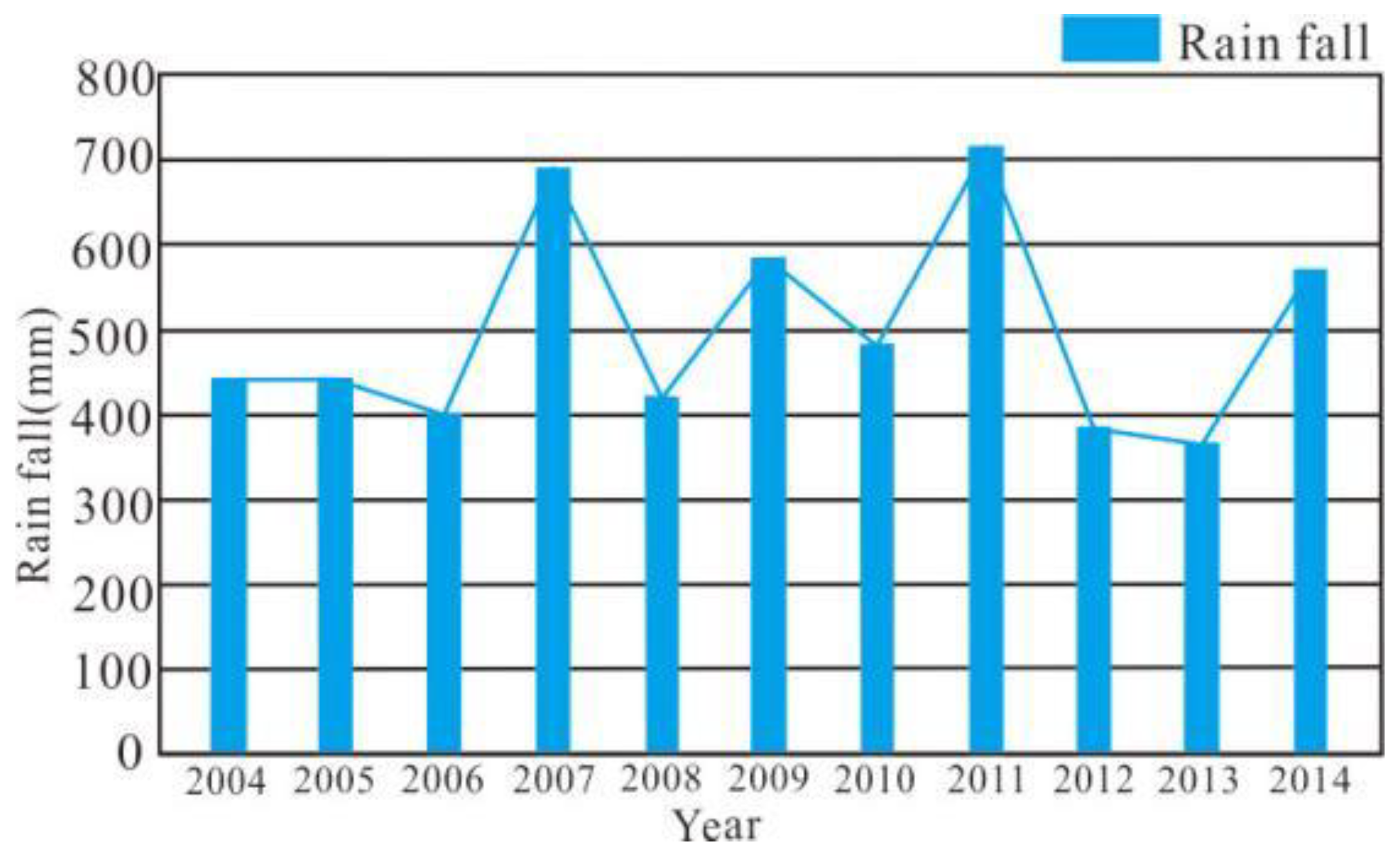
According to previous geological investigations, the ground fissures in the research area mainly appear as bead-like or large sinkholes with cavities in the shallow layer, and their activity increases significantly after rainfall. The annual maximum precipitation in the research area is 829.7 mm, and the minimum is 290.1 mm. According to the meteorological bureau’s detection (Figure 9) and investigation, the frequency of ground fissure activity was higher from 2007 to 2009, indicating a close relationship between the opening of water-eroded ground fissures and rainfall. The terrain in the research area has a common characteristic of being higher in the north and lower in the south, and the terrain changes in elevation provide potential energy for surface water and groundwater. Under conditions of heavy rainfall, rainwater will flow to low-lying areas, and groundwater in higher areas will also have hydraulic gradients, thus providing lateral flow force. In addition, a large amount of surface water generated by rainfall will flow downward through preferential channels (hidden fissures), thus providing terrain conditions for the development and generation of water-eroded ground fissures.

Figure 9.
Precipitation Histogram of Jingyang from 2004 to 2014.
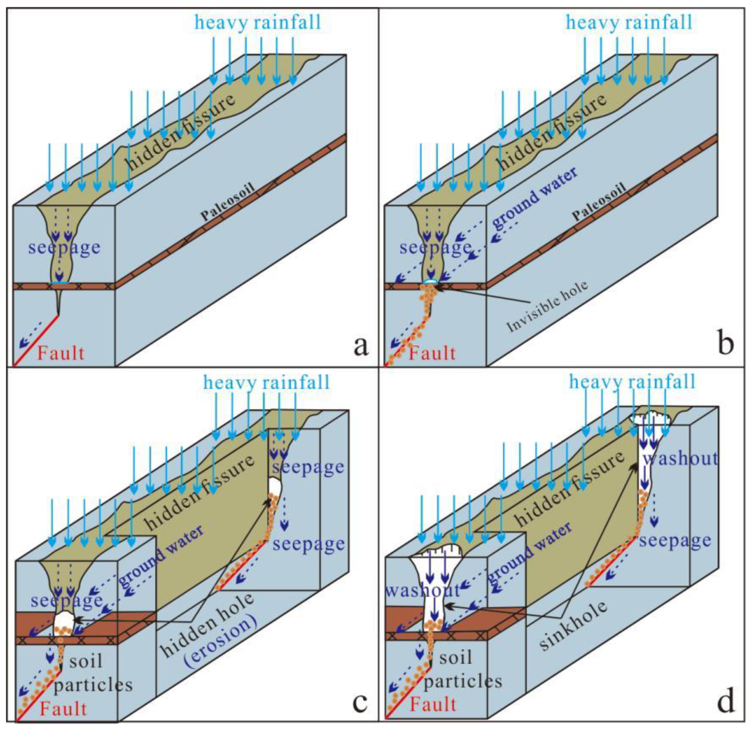
The geological strata in the study area have the characteristics of alternating loess and paleosoil (Figure 2a). Loess has good permeability while paleosoil soil has good impermeability. This feature lays the foundation for the expansion of underground cavities. Surface water infiltrates into the first layer of paleosoil or clay layer through hidden fissures and water conduits, and then gathers to erode the easily eroded loess (Figure 10a). Part of the eroded soil migrates downward along the fissures with the infiltrated water, while the other part migrates laterally with the groundwater flow. With the continuous migration of eroded particles, small cavities are formed (Figure 10b). Under repeated erosion, small cavities develop into larger cavities (Figure 10c) and then expand upward to form sinkholes (Figure 10d).
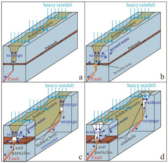
Figure 10.
Water erosion process [20] (modified from Wang et al., 2019): (a) water collects to form hole; (b) cavitation is formed by erosion; (c) collapse to form cavity; (d), further collapse to form pit.
4.3. Mechanical Analysis of Collapse
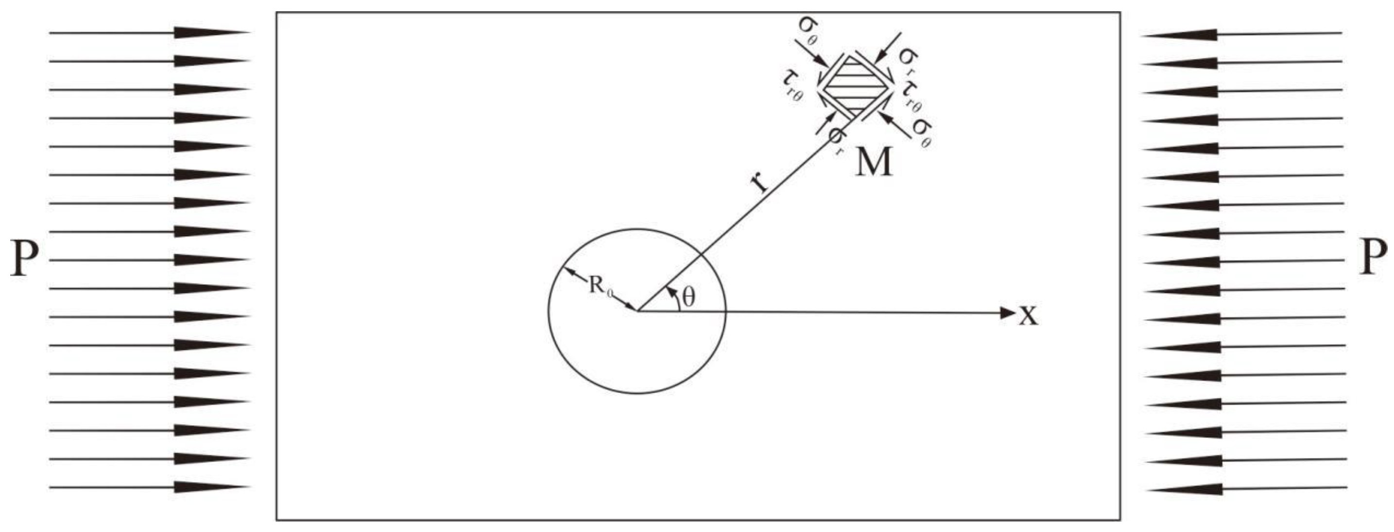
The formation of cavities is one of the important characteristics of water-eroded ground fissures. First, let us assume that this type of rock and soil can be approximately considered as a isotropic, continuous, and homogeneous linear elastic body, and the stress distribution of the surrounding rock can be calculated using the method of elastic mechanics, analyzing it as a circular cavity.
Formula (1) is the stress calculation formula for the periphery of a central hole in an infinite thin plate solved in a Cauchy problem (Figure 11), the process can be described as follows: is the compression zone, is the aperture size, is the normal stress in the direction, is the normal stress in the direction, and is the shear stress. This is applied to the calculation of stress redistribution in the surrounding rock of underground cavities.
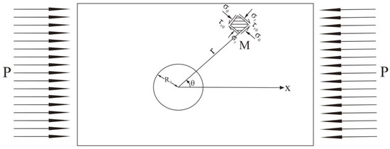
Figure 11.
Stress analysis of the Cauchy problem: , compression zone; , aperture size; , shear stress; and and , normal stress.
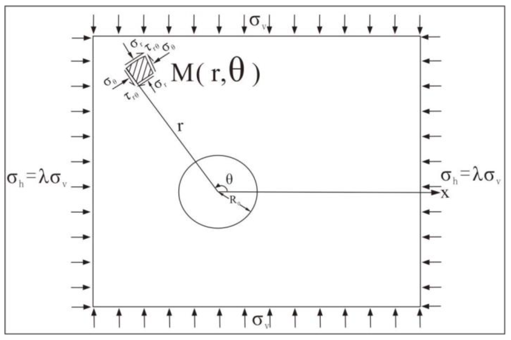
By substituting into , the stress redistribution caused by the vertical natural stress can be obtained. Combining it with the stress redistribution caused by the horizontal natural stress (). Where, the relationship between and is . The Formula (2) for the stress distribution of surrounding rock of a circular cavity (Figure 12) can be derived.
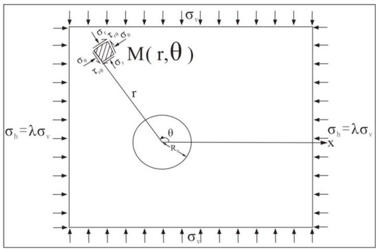
Figure 12.
Stress analysis model for surrounding rock of underground caves: , vertical natural stress; , horizontal natural stress; , aperture size; , shear stress; and and , normal stress.
When , the redistributed stress on the cavity wall is:
From Equation (3), it can be seen that there is only acting on the tunnel wall, and is related to the natural stress state and the position of the calculation point, and has nothing to do with the size of the cave.
When there is a vertical crack in the rock and soil, it can be regarded as a weak structural plane intersecting with the borehole wall along the vertical diameter. According to Equation (2), when , there is no shear stress on the structural plane; however, when , tensile stress will be generated at the top and bottom of the borehole. Under this tensile stress, the weak structural plane will be pulled apart, forming a stress reduction zone in an elliptical shape at the top and bottom (Figure 13).
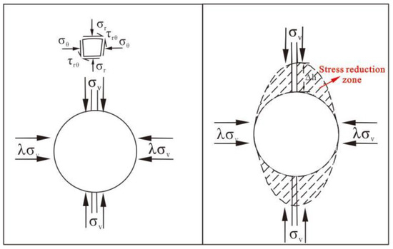
Figure 13.
The effect of vertical cracks on redistributed stress: , vertical natural stress; , horizontal natural stress; , shear stress; and , normal stress; , stress relaxed area.
The short axis of the ellipse is the same as the horizontal diameter of the cavity, which is . The long axis is parallel to the structural plane and has a size of , where is determined by the following Equation (4):
5. Conclusions
The water-eroded ground fissures in the study area are primarily characterized by the appearance of string-of-pearls-like sinkholes and cavities in the shallow parts.
The characteristics of water-eroded fissures in the study area are as follows:
(1) These three fissures are distributed along corresponding fault zones. Their orientations are closely related to local topographic changes, and cavities are generated above the paleosoil layer.
(2) The regional tectonics provide initial fracture dynamics, creating advantageous water conduits for surface water and groundwater; the northern high and south low terrain environment provides space for surface water and groundwater, and creates conditions in this space for the convergence of surface water and the flow of groundwater.
(3) The sandwiched stratigraphic structure of loess and paleosoil provides the basis for water seepage, water isolation, and water collection, and provides geological material conditions for the formation of water-eroded fissure cavities. A large amount of rainwater seeps into the soil along advantageous water conduits (hidden fractures), and over time, the upper layer of soil migrates downward continuously, eventually forming sinkholes.
(4) Sinkholes disturb each other, i.e., σ h decreases and λ decreases, when λ < 1/3, creating a stress reduction zone that promotes upward fracture propagation.
Author Contributions
Conceptualization, G.L. and F.W. (Feiyong Wang); methodology, G.L.; formal analysis, G.L.; investigation, G.L., F.W. (Feiyong Wang) and F.W. (Fujiang Wang); data curation, G.L.; writing—original draft preparation, G.L.; writing—review and editing, F.W. (Feiyong Wang), Y.Z. and X.G.; funding acquisition, F.W. (Feiyong Wang). All authors have read and agreed to the published version of the manuscript.
Funding
This study was funded by the National Science Foundation of China (NO. 42207202, 42293351, 2022XAGG0400), the CRSRI Open Research Program (Program SN: CKWV2021873/KY), the Fundamental Research Funds for the Central Universities (NO. 2-9-2021-014), and the Key Laboratory Open Fund (NO. EFGD2021-05-02, 300102262509).
Data Availability Statement
Data is contained within the article.
Conflicts of Interest
The authors declare no conflict of interest.
References
- Lee, C.F.; Zhang, J.M.; Zhang, X.Y. Evolution and origin of the ground fissures in Xi’an, China. Eng. Geol. 1996, 43, 45–55. [Google Scholar] [CrossRef]
- Burbey, T. The influence of faults in basin-fill deposits on land subsidence, Las Vegas Valley, Nevada, USA. Hydrogeol. J. 2002, 10, 525–538. [Google Scholar] [CrossRef]
- Sheng, Z.; Helm, D.C.; Li, J. Mechanisms of earth fissuring caused by groundwater withdrawal. Environ. Eng. Geosci. 2003, 9, 351–362. [Google Scholar] [CrossRef]
- Ayalew, L.; Yamagishi, H.; Reik, G. Ground cracks in Ethiopian Rift Valley: Facts and uncertainties. Eng. Geol. 2004, 75, 309–324. [Google Scholar] [CrossRef]
- Pacheco-Martínez, J.; Hernandez-Marín, M.; Burbey, T.J.; González-Cervantes, N.; Ortíz-Lozano, J.Á.; Zermeño-De-Leon, M.E.; Solís-Pinto, A. Land subsidence and ground failure associated to groundwater exploitation in the Aguascalientes Valley, México. Eng. Geol. 2013, 164, 172–186. [Google Scholar] [CrossRef]
- Kalogirou, E.E.; Tsapanos, T.M.; Karakostas, V.G.; Marinos, V.P.; Chatzipetros, A. Ground fissures in the area of Mavropigi Village (N. Greece): Seismotectonics or mining activity? Acta Geophys. 2014, 62, 1387–1412. [Google Scholar] [CrossRef]
- Conway, B.D. Land subsidence and earth fissures in south-central and southern Arizona, USA. Hydrogeol. J. 2015, 24, 649–655. [Google Scholar] [CrossRef]
- Gaur, V.P.; Kar, S.K.; Srivastava, M. Development of Ground Fissures: A Case Study from Southern Parts of Uttar Pradesh, India. J. Geol. Soc. India 2015, 86, 671–678. [Google Scholar] [CrossRef]
- Peng, J.; Qiao, J.; Sun, X.; Lu, Q.; Zheng, J.; Meng, Z.; Xu, J.; Wang, F.; Zhao, J. Distribution and generative mechanisms of ground fissures in China. J. Asian Earth Sci. 2020, 191, 104218. [Google Scholar] [CrossRef]
- Wang, F.; Peng, J.; Chen, Z.; Wang, Q.; Meng, Z.; Qiao, J.; Zhao, J. Development characteristics and mechanisms of damage-causing urban ground fissures in Datong City, China. Eng. Geol. 2020, 271, 105605. [Google Scholar] [CrossRef]
- Leonard, R.J. An Earth Fissure in Southern Arizona. J. Geol. 1929, 37, 765–774. [Google Scholar] [CrossRef]
- Ramelli, A.R.; dePolo, C.M.; Yount, J.C. Ground Cracks Associated with the 1994 Double Spring Flat Earthquake, West-Central Nevada. Bull. Seismol. Soc. Am. 2003, 93, 2762–2768. [Google Scholar] [CrossRef]
- Williams, F.M.; Williams, M.A.J.; Aumento, F. Tensional fissures and crustal extension rates in the northern part of the Main Ethiopian Rift. J. Afr. Earth Sci. 2004, 38, 183–197. [Google Scholar] [CrossRef]
- Peng, J.; Meng, L.; Lu, Q.; Deng, Y.; Meng, Z. Development characteristics and mechanisms of the Taigu–Qixian earth fissure group in the Taiyuan basin, China. Environ. Earth Sci. 2018, 77, 407. [Google Scholar] [CrossRef]
- Wang, F.; Xun, S.; Peng, J.; Huang, Q.; Lu, Q.; Meng, Z.; Qiao, J.; Liu, Y.; Jia, Z.; Zhao, J. A study of the symbiotic relationship between tectonic fissures and faults in the Fenwei Graben System, China. Environ. Earth Sci. 2020, 79, 212. [Google Scholar] [CrossRef]
- Wang, F.; Peng, J.; Lu, Q.; Meng, Z.; Qiao, J.; Zang, M.; Zhao, J. Development characteristics and dynamic mechanisms of tectonic ground fissures in Weihe Basin, China. Bull. Eng. Geol. Environ. 2021, 81, 12. [Google Scholar] [CrossRef]
- Peng, J.; Sun, X.; Lu, Q.; Meng, L.; He, H.; Qiao, J.; Wang, F. Characteristics and mechanisms for origin of earth fissures in Fenwei basin, China. Eng. Geol. 2020, 266, 105445. [Google Scholar] [CrossRef]
- Liu, Y.; Peng, J.-b.; Jiang, F.-q.; Lu, Q.-z.; Zhu, F.-j.; Qiang, X. Model test study on the formation and development of underground erosion ground fissures in the Kenya Rift Valley. J. Mt. Sci. 2022, 19, 1037–1050. [Google Scholar] [CrossRef]
- Peng, J.; Wang, F.; Cheng, Y.; Lu, Q. Characteristics and mechanism of Sanyuan ground fissures in the Weihe Basin, China. Eng. Geol. 2018, 247, 48–57. [Google Scholar] [CrossRef]
- Wang, F.; Peng, J.; Lu, Q.; Cheng, Y.; Meng, Z.; Qiao, J. Mechanism of Fuping ground fissure in the Weihe Basin of northwest China: Fault and rainfall. Environ. Earth Sci. 2019, 78, 407. [Google Scholar] [CrossRef]
- Peng, J.; Qiao, J.; Leng, Y.; Wang, F.; Xue, S. Distribution and mechanism of the ground fissures in Wei River Basin, the origin of the Silk Road. Environ. Earth Sci. 2016, 75, 718. [Google Scholar] [CrossRef]
- Zang, M.; Peng, J.; Qi, S. Earth fissures developed within collapsible loess area caused by groundwater uplift in Weihe watershed, northwestern China. J. Asian Earth Sci. 2019, 173, 364–373. [Google Scholar] [CrossRef]
- Lu, Q.; Liu, Y.; Peng, J.; Li, L.; Fan, W.; Liu, N.; Sun, K.; Liu, R. Immersion test of loess in ground fissures in Shuanghuaishu, Shaanxi Province, China. Bull. Eng. Geol. Environ. 2020, 79, 2299–2312. [Google Scholar] [CrossRef]
- Wang, Z.-F.; Cheng, W.-C.; Wang, Y.-Q. Investigation into geohazards during urbanization process of Xi’an, China. Nat. Hazards 2018, 92, 1937–1953. [Google Scholar] [CrossRef]
- He, Z.; Ma, B.; Long, J.; Zhang, H.; Liang, K.; Jiang, D. Recent ground fissures in the Hetao basin, Inner Mongolia, China. Geomorphology 2017, 295, 102–114. [Google Scholar] [CrossRef]
- Sun, P.; Peng, J.-B.; Chen, L.-W.; Yin, Y.-P.; Wu, S.-R. Weak tensile characteristics of loess in China—An important reason for ground fissures. Eng. Geol. 2009, 108, 153–159. [Google Scholar] [CrossRef]


Disclaimer/Publisher’s Note: The statements, opinions and data contained in all publications are solely those of the individual author(s) and contributor(s) and not of MDPI and/or the editor(s). MDPI and/or the editor(s) disclaim responsibility for any injury to people or property resulting from any ideas, methods, instructions or products referred to in the content. |
© 2023 by the authors. Licensee MDPI, Basel, Switzerland. This article is an open access article distributed under the terms and conditions of the Creative Commons Attribution (CC BY) license (https://creativecommons.org/licenses/by/4.0/).