1. Introduction
The sustainable management of water resources in the context of global change is a complex task that needs to be accomplished using multiple approaches. The urban, industrial, and agricultural use of water and their relationship with food, energy, and biodiversity must be quantified with precise hydrological tools as, for example, groundwater modeling and/or the development of new hydrological indexes, to allow a better understanding of the relative importance of specific hydrological processes. Densely populated or agricultural coastal areas, where access to fresh surface water commonly is limited, are largely dependent on groundwater. In a semi-arid climate, where surface water is scarce, and its availability is intermittent, the use of groundwater resources constitutes more than 80% of the total water use for urban and irrigation demand [
1]. On the other hand, groundwater is essential for the maintenance of dependent ecosystems, such as outstanding universal value (OUV) ponds and lagoons. To be deemed of outstanding universal value, a property must also meet the conditions of integrity and/or authenticity and must have an adequate protection and management system to ensure its safeguarding, as stated in the Operational Guidelines for the Implementation of the World Heritage Convention.
It is well known that the demand for groundwater as a safe alternative to surface water will increase because of rapid population development, growing demand for food and urbanization, and climate change. Climate change is expected to alter drought occurrence and intensity. Increased drought duration in many parts of the world will further challenge drought mitigation strategies [
1]. In fact, drought is one of the major causes of agricultural, economic, and environmental damage [
2]. It remains difficult to determine the onset, intensity, and duration of drought in spite of a great number of studies committed to this effort [
2,
3,
4]. One of the significant challenges in drought studies is the limited availability of long-term climatic datasets, which are crucial for the development of robust climatic models, including drought predictive models. In recent decades, numerous efforts have been made to develop and enhance drought indices. Among these, the standardized precipitation index (SPI) has emerged as a valuable tool for assessing drought dynamics in a specific region [
4]. Despite being relatively effective, this indicator has several flaws [
2]. One of the problems of using the SPI as a drought indicator is that its calculation is exclusively based on precipitation data. Other variables associated with drought, such as air temperature, are not included. The standardized precipitation evapotranspiration index (SPEI) is based on precipitation and air temperature data [
2]. The calculation of this index uses the accumulated differences between precipitation and potential evapotranspiration (see
Section 2 below). Therefore, it is an excellent method to model the effects of global warming on drought situations.
Several studies were conducted for the sustainable management of groundwater in the context of global change, using meteorological, agricultural, and hydrological indexes. The European Groundwater Drought Initiative, a pan-European collaboration, has recently highlighted the major gaps in European drought research capability related to groundwater droughts. Among the most important research performed in this area, an index was developed [
1] to determine groundwater drought, i.e., the continuous and extensive occurrence of the below average availability of groundwater. The index was named Groundwater Recharge Drought Index (GRDI). One of the main results of this work was that they were able to separate the human effects on the hydrological system from the effects of natural drought. The application of this index could also be applied to assess the sustainable management of coastal aquifers.
In a recent risk assessment of the ecological damage due to groundwater abstraction in the study area of the present work, Doñana National Park (henceforth, DNP), one of the main conclusions was that appropriate indicators to study the hydrological context of the detrital aquifer are urgently needed [
5]. Moreover, the information that we complied from EUROCODEX project for the Doñana area is quite in agreement with the studies performed over all the Guadalquivir catchment for climate change scenarios (i.e., RCP 4.5 or RCP 8.5 scenario from IPCC panel).
The authors considered that the level of scientific uncertainty is unacceptable for an iconic World Heritage site such as the DNP. To avoid any potential risk to the groundwater-dependent OUV ecosystems within DNP, it is highly recommended that the evolution of the groundwater recharge in the aquifer is studied in the future, and that an integrated water resources management is implemented. A common practice to assess this issue is to analyze future climate projections downscaled from global climate change models.
With the given suggestion in mind, the primary goals of this paper are as follows:
Incorporate historical climatic data from DNP to enhance the SPI, SPEI, and GRDI models.
Contrast these indices with those employed by the managers of DNP.
Utilize these indices to predict climatic patterns (2030–2059) under two climatic scenarios, namely RCP 4.5 and RCP 8.5 by IPCC.
1.1. Study Site
1.1.1. Climate
The DNP experiences a Mediterranean climate with hot, dry summers and mild, wet winters. During the summer months, temperatures can soar to over 40 °C while winter temperatures typically range from 5 to 15 °C. The study area receives most of its rainfall in the winter months, with an average (1970–2022 period) of 525 mm of precipitation per year. These weather conditions create a diverse landscape in Doñana, with a mix of wetlands, dunes, and forests.
1.1.2. Hydrogeology
The aeolian littoral mantle of Doñana, where we focused this study, is an unconfined dune aquifer that forms part of the Almonte-Marismas detrital aquifer system (
Figure 1), in southwest Spain. This area is located between the marshes and the sea, where many coastal ponds, situated in the dune slacks, are supported. These dune-slack ponds are mostly temporary and are directly supplied by rainfall and groundwater [
5,
6]. In the case of Santa Olalla pond, which is a permanent coastal pond, only 20% of the water inputs comes from direct rainfall and 80% from groundwater discharge [
7].
The hydroperiod of the dune ponds is determined by the discharge coming from the aeolian sand aquifer, which is recharged by rainfall. Some of the ponds were significantly affected by the lowering of the groundwater levels in the aeolian aquifer due to changes in rainfall and to pumping for public water supply to Matalascañas [
7]. There is a hydrological connection between the aeolian sand aquifer and deeper regional detrital aquifer, which also influences the pond’s hydrology. The aeolian system developed continuously from the beginning of the formation, first covering the alluvial sediments of the Almonte Formation and then non-lapping over the lateral equivalents of the Lebrija and Marismas formations [
5]. Depending on the location and altitude of the ponds, their hydrology is determined to a greater or lesser extent by both the local groundwater fluxes within the aeolian sand aquifer and the regional groundwater levels [
8].
1.1.3. Water Management
Doñana is an area enclosing a variety of conflicting water resource demands required to maintain agriculture, industry, and tourism [
9]. The Confederación Hidrográfica del Guadalquivir (CHG) is the administrative organization responsible for managing water resources in the Guadalquivir river basin in southern Spain, where the study area is encompassed. In 2020, CHG officially declared that 3 of the 6 groundwater bodies in Doñana were overexploited. In recent years, the region has been affected by prolonged droughts, which have had a significant impact on agriculture, tourism, and the environment. To address this issue, the CHG developed a drought management plan that aims to improve the resilience of the region’s water resources. This plan includes measures such as the construction of the new hydraulic infrastructure, the promotion of water conservation practices, and the implementation of more efficient irrigation systems. Additionally, the CHG is working with local stakeholders, such as farmers and tourism operators, to raise awareness about the importance of water conservation and to develop strategies for adapting to the changing climate. While the plan is still in its early stages, it is expected to represent a crucial step towards ensuring the long-term sustainability of water resources in the Guadalquivir river basin.
4. Discussion
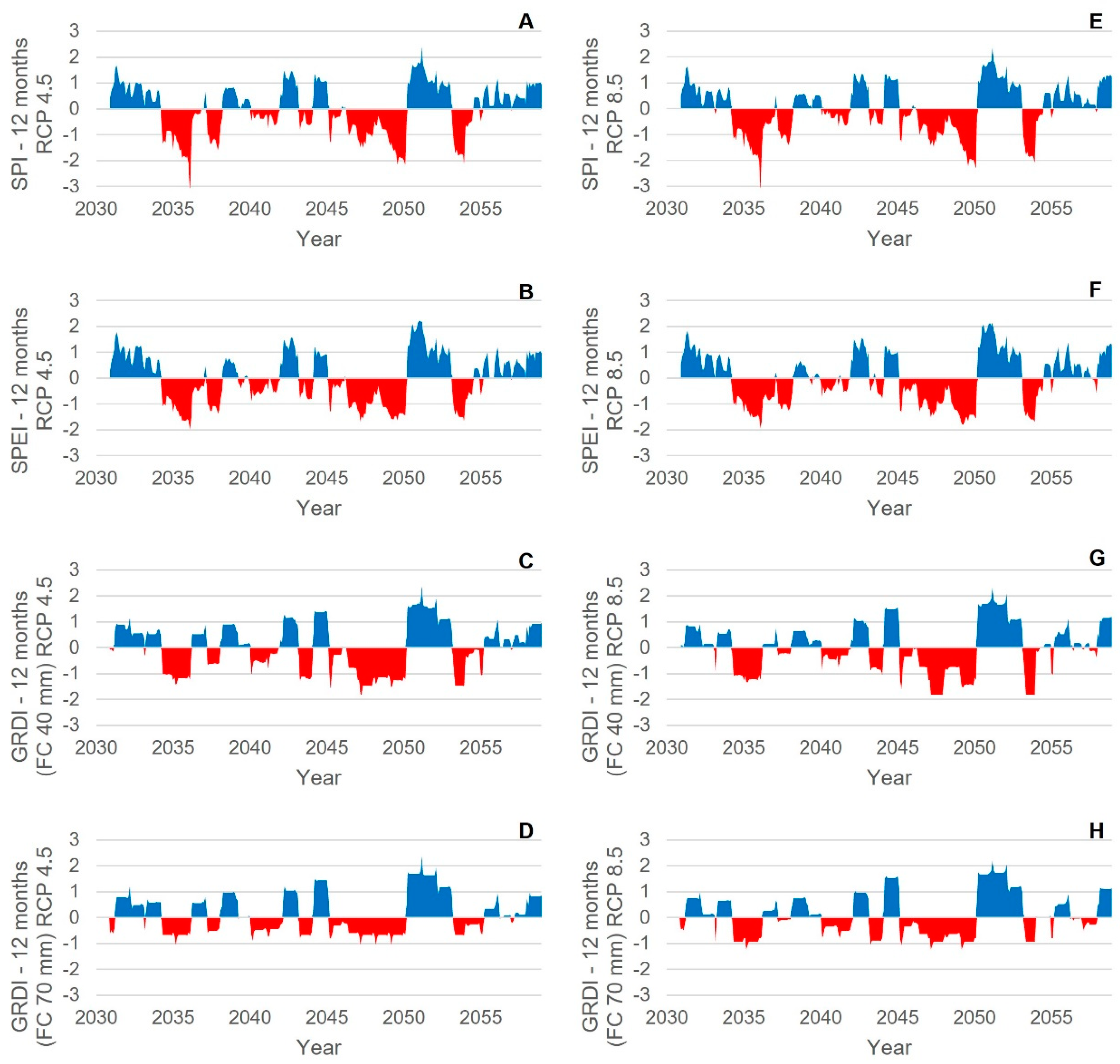
The comparison of the performance of SPI an SPIE in our case study reveals temporal consistency between both indexes (R
2: 0.98 between SPI-12 and SPEI-12 during the period 1976–2017). Similar results were obtained in Mongolia [
20]. When using SPI or SPEI to estimate the length and intensity of the droughts in the Doñana area, results are very similar. This fact can be interpreted to be of low importance in terms of evaporation in the drought assessment, compared to precipitation.
GRDI estimations with the different soil capacities (40 mm and 70 mm) are very similar for wet periods (R
2: 0.96 between GRDI-40 and GRDI-70 during the period 1976–2017). For dry periods, GRDI has more extreme values when the soil capacity is lower, and groundwater recharge is less damped by the soil effect. The length of drought periods remains similar for the three indexes used. Slight differences in GRDI (
Figure 5C,D,G,H) are because of the soil parameters that influence recharge.
This study is the first to report a specific future drought classification in the Doñana area, building on the global climate change models. Although there are previous studies that have focused on temperature, precipitation, and groundwater recharge changes [
9,
18], they do not take into account the occurrences of droughts.
According to the Guadalquivir hydrological planning [
21], in the RCP 4.5 scenario (RCP emission stabilization scenario), the average rainfall decrease between 1980–2018 and 2039 will range from 3.0% to 4.6%. We obtained that, for precipitation, there will be a decrease of 13% for the RCP 4.5 and 12% for RCP 8.5. In RCP 8.5 (scenario of increased RCP issuance), the decrease is almost triple, ranging between 10.6% and 13.0%. For the IPCC RCP 4.5 and RCP 8.5 climate scenarios, our results regarding the temperature give similar increase values compared to other studies in the whole Guadalquivir catchment [
21]. The average minimum temperature will increase between 11 and 15% and the average maximum temperature between 5% and 6%. Higher values are expected in the Doñana area during the period 2071–2100, with increases between 1.2 °C and 7.4 °C [
9].
Consistent with findings from other researchers in the study area, our study also demonstrates that simulated recharge is lower under future climate scenarios. Guardiola-Albert and Jackson [
9] estimated that, by the year 2080, aquifer recharge would experience an average decrease of 14–57% compared to historical data from 1975 to 1998. This decrease in recharge is associated with a substantial decline in groundwater levels of up to 17 m. More recent modeling based on the RCP 4.5 scenario for the year 2039 shows an average reduction of 8.5% compared to the average from 1980 to 2018. For the RCP 8.5 scenario, the reduction is more than double, with an average of 18.2% and ranging from 17.6% to 18.8% [
21].
In our study, the simulated mean recharge was statistically lower (Steele–Dwass,
p-value < 0.05) during the middle (2040–2069) to late (2070–2099) 20th century in comparison to the historical period (1950–2009). These results align with the conclusions drawn by Taylor et al. [
21] for southern Europe as a whole. Additionally, the similar findings of decreased recharge due to climate scenario simulations have been reported in other regions such as Greece [
22] and China [
23]. The latest research in Doñana area states that climate change is likely to become the greatest risk to the degradation and availability of water resources in this protected wetland [
5]. It is very likely that the greatest threat to many of Doñana’s dependent ecosystems, for example, the peridune lagoons, is related to these drought episodes. According to the Guadalquivir Hydrological Plan 2022–2027 [
21] there is no likely significant increase in flood risk as a result of climate change. Instead, there will be a higher frequency of droughts, especially 5-year droughts.
Although there was evidence from modeling that climate change could alter the hydrology and ecology of the Doñana in the future, the result of the present study does not pose evidence of an increment of droughts. Our results show a similar frequency of droughts, for the same period length of 30 years: two long periods of drought of four and five years, respectively. The significant difference is obtained for the wet periods. The periods with severely to extremely wet SPIs were 25% lower in future predictions with respect to the historical time series. In addition, the periods with severely to extremely wet SPEIs were 38% lower in future predictions with respect to the historical time series. This is precisely the current reality, as, since 2011, there has not been any wet year. This phenomenon is resulting water resources scarcity in Doñana area, which also happens in the drought periods. The significant increment in mean and maximum temperatures, which would result in a subsequent increment of ET in the area, reduces recharge rates and adds a negative effect to the OUVs of the park.
In a recent academic report [
8], some of the precipitation, temperature and ET data obtained in this research were used to model the daily evolution of the depth of one of the most important OUV ponds of Doñana, namely Santa Olalla pond. This is the only permanent pond of DNP and it is highly dependent on rainfall and the groundwater discharge from a local groundwater system. A one-dimensional model was developed to simulate the daily variations in the depth of the pond from 2030 to 2060. This modeling approach enabled the authors to predict the future condition of the pond. After calibrating and validating the model, the results indicated that the pond would experience complete drying periods starting from 2038. These dry periods would span a total of nine years, accounting for 30% of the modeled time period. Furthermore, the study projected a reduction in rainfall, although maximum daily precipitation events could still reach values as high as 156 mm/day. Another noteworthy finding from this study is the estimation of actual daily direct evaporation from the pond, which was projected to reach 15 mm/day. The average daily evaporation was determined to be 4 mm/day. See “
Supplementary Material” for more information about this report [
24]: Current water regime and modeling during the 21st century in Santa Olalla pond (Doñana National Park), presented in Spanish in 2021.
In another recent study conducted in Doñana National Park on groundwater recharge in arid and semiarid climates [
6] used a spatio-temporal kriging algorithm to analyze the rainfall variability during a long period from 1975 to 2016 and found that monthly recharge estimations range between 21 and 91% of the maximum rainfall, with overestimations in areas with uneven rainfall measurement distribution. The regional average frequency of drought days (FDD) is anticipated to increase substantially in several regions, even during the first half of the 21st century, indicating that the regional drought conditions are likely to shift toward more severe conditions. However, unprecedented regional drought conditions, in which the regional average FDD is larger than the maximum value in the past 145 years and this FDD exceedance lasts longer than five consecutive years, are projected to not be unlikely in some regions by the end of the century, even in a low-emission scenario [
4].
Future Research and Implications for Decision Makers
Future research in the context of Doñana National Park holds significant implications for decision-makers, particularly concerning global water models (GWMs) and gravimetry (GRACE) telemetry. By incorporating these approaches, together with the advances in the prediction of droughts from the application of SPI, SPEI, and GRDI indices, valuable insights can be gained to enhance water resource management and address potential challenges. Future studies could explore the integration of global water models, which provide a comprehensive understanding of water availability and distribution patterns on a global scale, with local-scale data from Doñana. This integration can enable decision makers to make informed choices regarding water allocation and conservation strategies. Furthermore, the utilization of gravimetry telemetry, such as GRACE, can offer precise measurements of water storage changes, facilitating the monitoring of groundwater levels and the assessment of water availability in the region. These advancements in research hold great potential to guide decision-making processes, ensuring the sustainable management of water resources in Doñana National Park.
Although GWMs are important tools for predicting future drought conditions, they also have inherent model biases. These biases can stem from various factors, such as the inclusion or exclusion of stomatal response to CO
2 and vegetation dynamics, domestic and industrial water withdrawal, and land use. The socioeconomic growth that leads to an increase in water withdrawal can exacerbate stream drought, but it remains challenging to obtain accurate projections or scenarios regarding these sectors. Therefore, developing appropriate and feasible adaptation plans is crucial for overcoming the expected severe dry conditions. Our research highlights potential concerns regarding existing infrastructures and practices that were designed based on historical records or experiences. They may prove insufficient in the near future to cope with droughts and wet periods in a warmer climate, particularly in specific regions. Thus, together with recent geophysical techniques developed to improve knowledge of hydrological variability at the terrestrial scale, such as GRACE [
25,
26,
27], it is imperative to improve our preparedness in the given time horizon before unprecedented drought conditions arise. Our findings contribute to a better understanding of the factors that influence droughts, decreased wet periods, and the degree of changes in such climatic behavior in DNP in the future.
5. Conclusions
The results of this study reveal a significant statistical increase in both maximum and minimum temperatures within the DNP area during the period from 2030 to 2060. The temperature rise ranges from 1.1 °C to 1.6 °C under two different climate change scenarios predicted by the IPCC (RPC 4.5 and RPC 8.5). This temperature increase is expected to contribute to a decline in recharge rates due to increased evapotranspiration. Furthermore, there will be a reduction in the frequency of wet periods, and the mean precipitation is projected to decrease from 575 mm/year to 496 mm/year (RPC 4.5) and 493 mm/year (RPC 8.5) during this period.
The analysis of drought and pluvial events Indicates the occurrence of two significant drought periods and two notable pluvial events. This study suggests that the frequency of future drought periods will be similar to that of the past. However, it is important to note that the future predictions anticipate a decrease in the occurrence of severely to extremely wet periods based on SPI and SPEI indices. These wet periods are projected to be 25% and 38% lower, respectively, compared to the historical time series.
These findings provide valuable information for the competent authority to implement appropriate mitigation measures and establish a robust integrated water resources management (IWRM) framework in the basin. It is crucial for these measures to take into account the anticipated impacts of climate change. Overall, this study highlights the importance of integrating the effects of climate change in the basin’s water management strategies.


