Article

Risk of Degradation and Coastal Flooding Hazard on Geoheritage in Protected Areas of the Semi-arid Coast of Brazil

by
Thiara Oliveira Rabelo
1,
Marco Túlio Mendonça Diniz
1,*,
Isa Gabriela Delgado de Araújo
2,
Maria Luiza de Oliveira Terto
2,
Larissa Silva Queiroz
2,
Paulo Victor do Nascimento Araújo
3 and
Paulo Pereira
4
1
Department of Geography, Seridó Higher Education Center, Federal University of Rio Grande do Norte, Natal 59078-970, Brazil
2
Centre for Humanities, Literature and Arts, Federal University of Rio Grande do Norte, Natal 59078-970, Brazil
3
Federal Institute of Education, Science and Tecnology of Rio Grande do Norte, Natal 59015-300, Brazil
4
Institute of Earth Sciences, University of Minho, 4710-057 Braga, Portugal
*
Author to whom correspondence should be addressed.
Water 2023, 15(14), 2564; https://doi.org/10.3390/w15142564
Submission received: 26 May 2023 / Revised: 4 July 2023 / Accepted: 7 July 2023 / Published: 13 July 2023

Abstract

:
Geoconservation should be incorporated in the discussions regarding climate change impacts on geoheritage degradation, especially in coastal areas that are directly affected by extreme climate events. The geoheritage degradation risk in protected areas of the Brazilian semi-arid coast was assessed using a quantitative method. A correlation with the tidal flooding hazard predicted with the climate change scenario was also considered for the study areas. The results show that most of the geosites assessed present a high risk of degradation due, mainly, to their exposure to negligence and inadequate public management regarding their uses. All geosites located in the plain areas are exposed to the risk of flooding by rising tides, which is associated with human action and leads to worrying scenarios regarding the loss of scientific and aesthetic values. The collected data support the need to rethink geoheritage management in protected areas and the mitigation of problems that may become major threats in conjunction with global climate change.

1. Introduction

Conservation Units (CU; the nomenclature for protected areas in Brazil) are increasingly important spaces for the protection of the planet’s natural characteristics. The maintenance of these areas contributes to the balance of the environment and life on Earth, through functions such as carbon storage, climate control, fertility and soil erosion control, protection of stream banks, pollination, etc., but when it comes to protecting abiotic characteristics, little has been achieved [1,2]. Impacts related to the climate changes predicted for this century foresee possible modifications in the pattern of distribution of species, communities, and transformations in the abiotic part of the ecosystems. Bruno et al. [3] relating the global climate change scenario to marine protected areas state that anthropogenic carbon emissions will lead to acute and chronic disruptions, including increased storm intensity, sea level rise, altered resurgence regimes, ocean acidification, and deoxygenation.
Such impacts will occur, without distinction, both inside and outside protected areas. In Brazil, the CU are organized under the National System of Conservation Units (SNUC). However, Federal Law No. 9985/2000 [4] that governs the SNUC does not consider the occurrence of climate change and possible management actions to circumvent the problem within them [5].
Even if the SNUC aims for the protection of natural features, the CU in Brazil have major concerns related to biodiversity and in many aspects do not direct due attention to the geodiversity present in these areas. Therefore, the importance of geodiversity in protected areas is emphasized mainly because of its intrinsic value and also because it supports the maintenance of biodiversity.
Many works at national and international levels have pointed out the importance of geoheritage conservation in the last decades [6,7,8,9,10,11] as a basis for the conservation of the history of the Earth and the maintenance of life. Geoheritage is the part of geodiversity that presents high scientific value and whose conservation is desirable for present and future generations. Kubalíková et al. [12] highlight the importance of geoheritage for sustainable development and resilience to geological hazards at a global level.
Considering the current environmental context and the growing impact of geoconservation within earth sciences and nature conservation, some works [13,14,15,16] have raised awareness of the influence of climate change on the risk of geosite degradation. In a recent study applied to Mediterranean coasts, Sakar et al. [17] point out that the direct and indirect impacts of climate change are quite evident in coastal areas around the world and highlight that global mean sea level rise represents one of the most evident and deeply studied consequences of ongoing global warming.
Climate change, caused by human activities and the resulting increase in greenhouse gas emissions, has led to global warming, with temperatures rising by 1.1 °C above pre-industrial levels from 2011 to 2020 [14]. This has resulted in numerous adverse effects on natural environments across the globe. The continued growth of greenhouse gas emissions, driven by unsustainable energy use, land-use changes, and consumption patterns, has contributed to climate-related extremes in weather and climate events, with an emphasis on flood events. With higher temperatures, the Earth system has more energy. An increase in sea level and air temperature can intensify evaporation, which, consequently, can favor the formation of clouds. In hot weather, the air can retain more moisture, which can lead to an increase in the intensity, duration, and frequency of rainfall [14].
The Brazilian Panel on Climate Change (Painel Brasileiro para as Mudanças Climáticas-PBMC) [18], in 2016, pointed out impacts related to climate change in coastal cities in Brazil, such as sea level rise, changes in the frequency and intensity of storms and the increase in rainfall and ocean temperature. These changes can already be observed in extreme events that have been happening in the last decade in cities such as Rio de Janeiro, Recife, and Fortaleza. In 2023, the intensity of storms and abnormally high levels of rainfall caused a disaster on the northern coast of the state of São Paulo.
Studies developed on the semi-arid coast of Brazil indicate the potential effects of climate change. Souto [19], Boori [20], and Aguiar et al. [21] studied the estuary of the Apodi-Mossoró River covering the municipalities of Areia Branca, Mossoró, and Grossos on the northern coast of the state of Rio Grande do Norte. Aguiar et al. [22] indicate that besides the rise in sea level, climate change will involve variations in winds and increases in sea surface temperature. These would be quickly perceived in the region, given the physical condition of the coast, as well as the effects that could affect the existing mangroves and corals. Soares and Rabelo [23] also indicate changes in the coastal environment caused by climate change, bringing the first record of coral bleaching on the coast of Ceará.
In this work, we address the potential impacts of climate change on the geoheritage of the semi-arid coast of Brazil, especially in the section known as Costa Branca (“White Coast”) that covers protected areas in the states of Rio Grande do Norte and Ceará. Tourism is a prominent activity in these areas, occurring mainly in the form of community-based tourism. For this work, we highlight the Costa Branca Tourist Pole, which according to Souza [24] is located in the western part of Rio Grande do Norte and goes up to the border with the state of Ceará. According to the authors, this region is the one that presents the least investments for tourism development compared to the other tourist poles located in coastal areas of the state.
In the region of Icapuí, in Ceará, a similar scenario affects the communities of Ponta Grossa, Redonda, Requenguela, and Tremembé, reporting that tourism in the area has a history of popular participation and a high level of politicization [25]. However, even if these areas are excluded from municipal political actions for tourism, they remain organized and productive in the community development of tourism and attracting visitors and the settlement of second homes.
The high human occupation in Brazilian coastal cities is also to be considered since it increases the potential risk related to natural disasters. The PBMC [18] points out that the most vulnerable areas to climate change are those with higher population density, which in the case of Brazil are also associated with coastal areas since 60% of the Brazilian population lives in coastal cities.

2. Materials and Methods

Twelve geosites were previously inventoried in the Costa Branca [26,27,28]. With the main aim of assessing the geoheritage risk of degradation related to climate change, a quantitative approach was performed by applying a method based on well-established concepts: fragility, vulnerability, and public use Table 1; [11,12].
This methodological analysis is in line with the main assessment methods based on the quantification of values, fieldwork, inventories, and other procedures considered essential for geoheritage analysis [29]. Some works applied to the reality of coastal environments in Brazil worked with degradation risk using similar concepts [30,31,32,33]. In this work, we apply a method that considers the three main criteria proposed by Selmi et al. [16]: natural vulnerability, anthropogenic vulnerability, and public use. Costa Branca is a section of the Brazilian semi-arid coast mostly covered by protected areas presenting specific vulnerability and fragility scenarios, being extensively used as tourism spots. Diniz et al. [34] pointed out that some of the sites analyzed in this archive could support a proposal for a geopark (the Costa Branca Geopark).

2.1. Study Area

Costa Branca is located in the region classified as the Brazilian semi-arid coast [35], which extends from Ponta do Mangue Seco (2°15′5″ S, 43°36′46″ W) in Maranhão, to Cabo Calcanhar (5°9′24″ S, 35°30′6″ W) in Rio Grande do Norte, with a length of approximately 1065 km. This part of the Brazilian coast is predominantly linear, with few indentations and the presence of beaches with ample spatial continuity.
Costa Branca is about 250 km in length and presents the largest sinuosity of the Northeast coast of Brazil with the presence of several deltaic features and high salinity in the waters of its deltas. The largest salt industries in Brazil are located there and are responsible for more than 97% of the Brazilian production of sea salt [36].
The coastal geoheritage analyzed is located in five CU (Figure 1): the Environmental Protection Area (EPA) Dunas do Rosado and the Sustainable Development Reserve (SDR) Ponta do Tubarão are located in the State of Rio Grande do Norte. The EPA Ponta Grossa, the EPA Barra Grande, and the EPA Arrombado are located in the State of Ceará.
These protected areas are considered Sustainable Use Conservation Units, according to the SNUC, allowing the presence of human activities in a sustainable manner according to their respective management plans. Table 2 presents the main characteristics of these CU geoheritage.
The diversity of the physical–environmental system of the Brazilian semi-arid coast is driven by the lithological and geomorphological contexts. The coastal systems are developed under the semi-arid climate, presenting a mosaic composed of large deltaic features, hypersaline plains, coastal terraces, and cliffs [35], with the main economic activities being aquaculture and sea salt production. Four main types of outcropping lithologies occur in the area, composed of a set of carbonate rocks (Jandaíra Formation) and siliciclastic rocks (Tibau, Barreiras, and Potengi Formations), besides mobile and fixed dunes, tidal plains, and beaches.
The 12 geosites inventoried in Costa Branca (Figure 1) have high scientific and aesthetic value due mainly to their representativeness of coastal landforms and the evolution of the Brazilian coast [26,27,28].
The geosites considered in our assessment, located in the state of Rio Grande do Norte are Ponta do Tubarão Estuarine System in the Ponta do Tubarão SDR, inventoried by Silva [21]; the geosites Falésias do Rosado, Dunas do Rosado and Falésias da Ponta do Mel, in the Dunas do Rosado EPA, inventoried by Silva [28], Terto [27], and Diniz et al. [34]. In the State of Ceará, the geosites are: Sítio Retirinho, Praia de Ponta Grossa, and Praia da Redonda, in the Ponta Grossa EPA; Praia de Picos and Vila Nova, Mirante Serra do Mar, and Requenguela Beach in the Marine Life Nurseries EPA; Mirante do Icapuí and Manibu Beach, in the Barra Grande Mangrove EPA, inventoried by Araújo [26] and Diniz, Araújo and Chagas [39] (Figure 2).
The rifting of Pangea causing the opening of the South Atlantic progressed northwards, up to this region. Close to the Borborema Province, there was a general NW-SE extension, that had as a reference the consistency of the basins with NE-SW orientation and the general trend in the proto-South Atlantic [41]. For the author, in the Brasiliano/Panafrican terrains the structural trends and weaknesses were NE-oriented, reactivated by normal faults, and the EW and NW-SE shear zones of the Proterozoic became potential sites of transfer faults and/or accommodation zones [42].
The spatial and chronological evolution of the sedimentary basins of the region were described by Matos [41] considering the work of Chang et al. [43]. The continental megasequence was fragmented into three stages. In the Syn-Rift I (Upper Jurassic), there was a reduced influence of faults and the filling of complex arid alluvial fans with coarse-grained fluvial sediments and associated evaporites. The Syn-Rift II (Lower Cretaceous) was characterized as one of the most significant, due to the supply of a series of semi-grasslands that sank rapidly along the entire margin, highlighting the northern part with the formation of deep, stratified lakes filled with shales and turbidites rich in organic matter linked to fluvio-deltaic clastic rocks, where later these lakes became shallower and more volcanic; the Syn-Rift III (late Barremian) with a final rift geometry of the East Brazilian marginal basins, and also when the sedimentation of the Cariri rift and onshore Potiguar Basin was aborted and large deformations started to occur in the Equatorial Branch [41,42].
In Costa Branca, two types of lithostratigraphic units occur. A carbonatic one, which is composed of the Jandaíra Formation; and the siliciclastic units represented by the Barreiras, Tibau, and Potengi Formations (Figure 3). Besides these units, Holocene deposits of mobile and fixed dunes, coastal ridges, tidal plains, and present beaches occur [44,45,46] as well as a dense fracture network, mainly to the southwest of the Municipality of Icapuí [45].
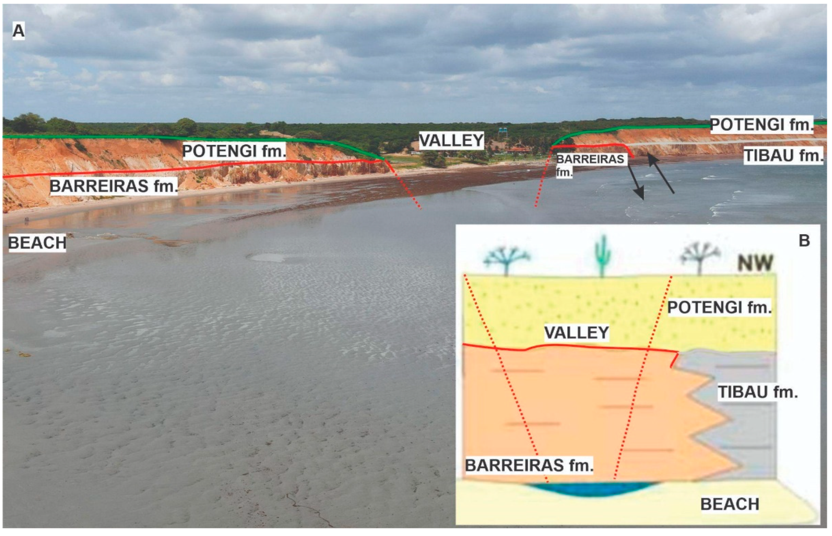
A lateral transition occurs between the Barreiras and Tibau formations (NW of the study area), as well as an overlap of the Potengi Formation on the other two (Figure 4). This can be observed mainly in the localities between Sítio Retirinho and Lagoa do Mato in Icapuí. The occurrence of faults with signs of strata basculation (10° to 20° to the east) and distension folds environments around the area of Retiro Grande testify that syndepositional tectonics acted in the Potengi Formation, which preserves its thickness along deformed sections [46,47].
In the Retirinho geosite, a large granite boulder with almost 2 m of diameter occurs in the Barreiras Formation (Figure 5). The Barreiras Formation in the area dates from the Miocene and there are no records in the literature of rivers in the area with such transport capacity. This deposit was recently discovered by cliff erosion and still has no scientific explanation for its occurrence.
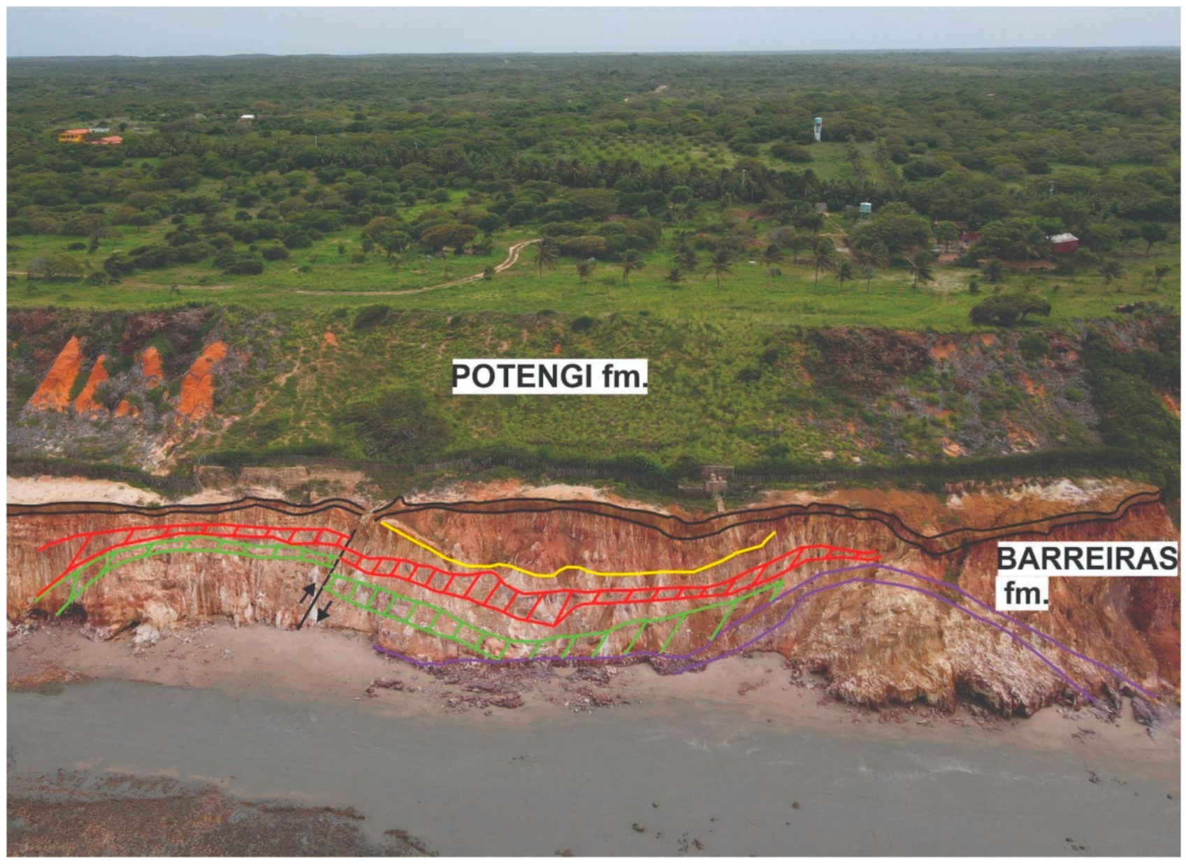
In the Ponta Grossa geosite, a system of distensional faults with structural inconsistencies can be observed in the Barreiras and Potengi formations. The cliffs of Ponta Grossa are mostly covered by dunes, reaching 80 m in height. A bypass from east to west transports the sediments to the beach. Next to this high coast section, a low coast occurs with Holocene marine terraces [39] (Figure 6).
Towards the east, deformations in the Barreiras Formation reappear at Praia da Redonda and Peroba, presenting layer tilting features, high and low-degree fractures, and fissures, similar to those that occur in Ponta Grossa geosite, with distensional and directional relict faults [46].
In Redonda Beach, the ocean is advancing over the coast and affecting the urban infrastructure, where structures have already been built to minimize the impacts of coastal erosion on houses and roads [39]. In Picos Beach, a mushroom rock landform was shaped by wind abrasion. These landforms are common in desert climates, although in this area of semi-arid climate, the intense winds were determinant for its formation, being a unique landform within a radius of at least 1000 km. Recently, it has suffered erosion of its upper part, losing its mushroom-like appearance (Figure 7).
In Vila Nova beach, the Barreiras Formation rocks occur with a contractional deformation type, related to the soft folds with hinge lines dipping to SSW in some points, reaching mainly the lower facies of this formation [46]. The rocks present stretching lineation, with exposure to dissolution processes and precipitation of quartz and iron oxide/hydroxide, as well as inverse faults with high angles, originating from a folding mechanism by flexural slip (Figure 8).
In the assessment of the geomorphological heritage of the coastal area of Icapuí (Ceará), two geodiversity sites were considered as key for the knowledge of the municipality coast: Mirantes de Icapuí and Serra do Mar. The former had its genesis related to the marine transgression of about 123 ka, reaching 6 m asl and originating the fossil cliff line and with the Last Glaciation Maximum (LGM) marine regression, which formed marine terraces remodeled in the subsequent transgression. The latter is related to a regression of about 2 ka, formed between 0.5 and 4 m asl, corresponding to 50% of the coastal plain [48,49].
The Requenguela Beach geosite is an essential support for the development of the mangrove ecosystem (Figure 9). An estuary of ebb tide delta type resulted from the mixing of the water table coming from the dunes with the ocean water. The area has characteristics of low wave energy and almost no longitudinal currents, which favors sediment deposition in the delta [39].
The Manibu Beach geosite is a typical example of a linear sandy beach (Figure 10), with a considerable tourist rate, mainly due to the proximity of Tibau Beach in the neighboring state of Rio Grande do Norte.
In the State of Rio Grande do Norte, Ponta do Mel Cliff geosite is located in the municipality of Areia Branca, where rainfall is very scarce. Fossil cliffs with marine terraces occur, with dunes in the foothills. The dunes are formed by wind channeled into the canyon that occurs in the area (Figure 11).
This coastal section contains the only tectonic landforms in the entire passive Atlantic portion of South America, which is a factor of global relevance. This is related to the uplift of the Serra do Mel dome structure (5.3 Ma), as a result of inversion compressional structures controlled by extensional regime faults that become active during compression, initiated in the rifting of the equatorial margin [50].
The dome uplift is reflected in the fossil cliffs of the coastal portion near the coastline, which reach an altitude of approximately 120 m [41] (Figure 12). Cenozoic sediments occur on the top, on the flanks, and on the base of the Serra do Mel dome structure. The occurrence of Quaternary deposits covering these structures nullifies the possibility that these differentiations are only a result of differential erosion [51] (Figure 12).
The Rosado Dunes geosite is located between the municipalities of Porto do Mangue and Areia Branca and contains the largest field of mobile dunes in the State of Rio Grande do Norte. The dunes form on the lee side of the Rosado Cliffs, having reddish coloration due to the wind erosion of the Rosado Cliffs. These reddish sediments mix with the lighter sands coming from the beach, giving the characteristic coloration to these dunes (Figure 13).
The Rosado Cliffs geosite corresponds to fossil cliffs constituted of non-consolidated Quaternary sediments. Its constitution is associated with post-Barreiras sedimentation on Pleistocene alluvial fans deposited on the Afonso Bezerra fault, which during the Holocene is in neotectonic activity [52].
The neotectonic uplift of Serra do Mel and the subsequent erosive processes generated alluvial fans that formed the Rosado cliffs during the Holocene maximum transgression. The uplift of the area is active in current times and the Holocene maximum transgression raised the sea level to approximately 2 m asl. The recent uplift identified at the base of the cliffs is about 10 m, which is due to the active tectonics of the Afonso Bezerra Fault. This area contains the only tectonic reliefs of the Brazilian coast, with the best example being the Ponta do Mel geosite [34].
The Ponta do Tubarão Estuary geosite is located in the municipality of Macau, near the Diogo Lopes village. The estuary occupies about 2000 ha and is a system consisting of barrier islands parallel to the coast, containing pontoons, tidal channels, and marine environments. In the tidal channels, sandy mudflats occur, visible during low tides [53].
In the margins of the estuary, the mangrove vegetation is quite present in the muddy areas of the tidal plain. In a generic way, the tide channel is considered an estuary, but with no connection to the river fresh water, with all continental water that supplies the mangrove coming from the water table (Figure 14).

2.2. Procedures for Quantitative Assessment

The quantification of the degradation risk of the coastal geoheritage of Costa Branca was performed according to the method of Selmi et al. [16]. These procedures were applied for the first time in Brazilian areas and focused on geoheritage assessment in Conservation Units. The main objective of the application of this method was to obtain a detailed quantitative assessment of the degradation risk based on the following criteria: natural vulnerability, anthropic vulnerability, and public use (Table 3). For this purpose, the method was adapted with the substitution of the term “geological element” for “geodiversity element”.
Regarding the “Public Use” criterion, the sub-criterion “population density” was adapted to the local reality, since all cities where the geosites are located have a population density below 100 inhabitants/km2. The total score of the degradation risk can vary from 0 to 33 points (Table 4). The geosites that achieve a score lower than 7 points are considered low degradation risk, while the highest degradation risk level is attributed to sites that achieve a total score higher than 25 points.
The assessment was based on qualitative data collected mainly through the analysis of photos and previous observations carried out in the fieldwork in March 2023 and during the stage of geoheritage inventorying [26,27,28].

3. Results and Discussion

The performed quantitative assessment shows that the Costa Branca geoheritage presents a risk of degradation classified as medium to high (Table 5).
The public use criteria present the highest scores that compose the degradation risk. The sub-criteria associated with public use are related to the human presence and the use of the geosites. All the geosites present high scores in the C7 criterion (access control), since none of them has control measures or inspection to human access, even being located in protected areas.
Most of the geosites have high scores for the degradation risk, with only 2 of the 12 geosites with medium level scores, namely the Rosado Cliffs and the Ponta do Mel Cliffs (Figure 15), both located in Rio Grande do Norte in the Dunas do Rosado EPA. These two sites are more stable within the coastal environment context, if compared to areas of dunes and beaches, due to the more consolidated lithologies and the height of these landforms, about 30 m and 120 m, respectively, further away from the direct effects of the ocean action. These characteristics contribute to lower scores in the natural vulnerability criteria, in comparison to the other sites.
Being located at the highest points of the Dunas do Rosado EPA, these two sites obtained also the lowest scores in the accessibility sub-criterion, due to the access difficulties related to the topography. Even though, the Ponta do Mel Cliffs geosite is frequently visited due to its aesthetic value and also to the associated cultural value, as it has already been the setting for movies and television series. Its characteristics resemble deserts of the north and Middle East, and usually, scenes of deserts are recorded in this area by Brazilian productions. The scientific value of these geosites is considered high according to Diniz et al. [34].
Natural gullying processes are present in these two geosites, mainly in the Rosado Cliffs; thus, these were considered when assessing the natural vulnerability, which influenced the degradation risk score. Unsustainable human activities may cause problems of geosite deterioration in the future. The scientific and aesthetic importance of these geosites associated with the risk of degradation shows that, even with a moderate risk of degradation, they need protection against human uses, mainly considering the development of tourism activity in the region.
The geosites that obtained scores ranging from 16 to 19 (high risk of degradation) are Rosado Dunes, Retirinho, Requenguela Beach, Manibu Beach, and Mirante da Serra do Mar. The Rosado Dunes are located in the same geoenvironmental macro-context as the Rosado Cliffs, though with easier accessibility and higher aesthetic appeal, which increases the risk of degradation.
The scientific value of this geosite is in the fact that it is the biggest field of mobile dunes in the state of Rio Grande do Norte. Furthermore, it presents in most of its extension, a reddish coloration due to iron oxide from sediments transported by the wind from the Rosado Cliffs geosite, constituting a unique feature in the region.
The deposition of sediments of the Rosado Dunes was considered in the criterion A1 (active processes) assessment. The dune field is currently surrounded by a grove of Prosopis juliflora (Sw) DC, popularly known as Algaroba, which has been present in the Brazilian Northeast since the 1940s. This grove occupies an area of marine terraces and has interrupted the supply of wind-borne sediments to the dune field from the beach and the marine terrace. The dense presence of this exotic species around the dune field is considered a natural physical barrier to the maintenance of the dune system, being an active biological process related to the natural vulnerability of this geosite in the medium and long term (Figure 16). In addition to the geodiversity degradation, the invasive species have caused biological pollution by suppressing the native vegetation that occupied the marine terraces and post-Barreiras deposits in the area. This process has been described in the literature as “greening” [54,55], although the fact that it occurs by invasive species deserves greater attention because, in addition to degrading geodiversity, the Algaroba is decreasing biodiversity in the area.
Criterion B1 (economic interest) also stands out in the area of Rosado Dunes, mainly due to the implementation of wind power generation plants in its surroundings. The installation of a power plant in the dunes would irreversibly compromise the conservation of this geosite, the only field of reddish dunes on the Atlantic coast of South America [34]. The dune field is still not being directly used for this purpose. However, in the last two years, there have been discussions and public hearings promoted by the Institute for Sustainable Development and Environment (IDEMA) of the State of Rio Grande do Norte, aiming at discussing the possibility of the implementation of a Wind Power Plant on the dunes, which is highly discouraged, with irreparable loss of the country’s geoheritage.
Retirinho geosite, located in the Ponta Grossa EPA, scored 16 points, with emphasis on the sub-criterion A1 (active processes) related to natural vulnerability. This is mainly due to the morphodynamic processes resulting from weathering, mass movements with sliding and landslides, deposition of sediments by wind action, and marine abrasion [39].
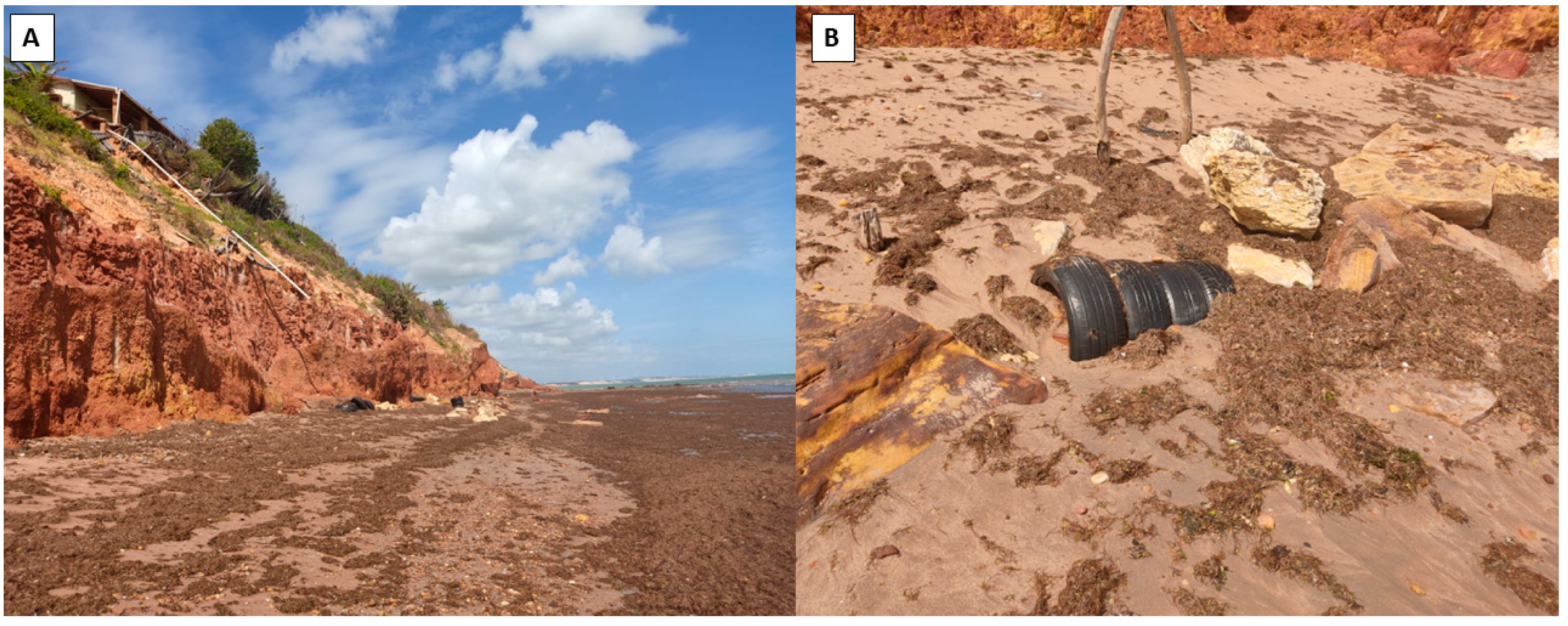
Sub-criteria C5 (physical protection), C6 (degrading use), and C7 (access control) obtained high scores for the composition of the Public Use criterion in this site. Degrading use stands out, due to the presence of solid waste and water and sewage drainage structures made without adequate planning (Figure 17).
Requenguela Beach geosite, located in the Barra Grande EPA, and Manibu Beach, located in the Arrombado EPA, stand out with a score of 18 points.
In quantifying the risk of degradation of this geosite, the highest scores were obtained in the “public use” criterion. We highlight the sub-criteria C2 (human proximity) and C3 (accessibility) since this site presents easy access and has human occupations within its coverage area. Besides the use of the site by the local population as a support for housing, the presence of ecotourism and sun and beach tourism stands out.
The Manibu Beach geosite has a similar assessment result, presenting high scores in the “public use” criterion due to the human occupations in almost the whole beach area, which correspond both to houses and bars and restaurants that aim to serve tourists and visitors (Figure 18).
The Mirante da Serra do Mar geosite scored 19 points. The panoramic view from the site is its main interest since many landforms can be observed from there (Figure 19). From these, a Holocene marine terrace largely occupied by permanent coconut agriculture stands out.
Almost all the area observed from the viewpoint is occupied by human activities, conditioning the high score obtained in almost all sub-criteria related to “public use”. Criterion C1 (legal protection) constitutes an exception since the geosite is located in an EPA, even without the proper controls of access and physical protections.
The viewpoints of the area were considered with a high risk of degradation because the assessment focused on the observed features and not the viewpoint itself. This procedure has been adopted according to the works regarding viewpoint geosites assessment [56,57].
The features observed in the Mirante da Serra do Mar geosite are marine terraces at low elevations and with the presence of agriculture. From the Icapuí viewpoint, the main urban nucleus and salt exploration activity can be seen, as well as Pleistocene terraces near the fossil cliff line and the mangrove ecosystem determined by the geomorphological environment. These viewpoints present the potential to attract sun and beach tourism practices, though they can support educational activities for all levels of education, concerning aspects referring to the advance and retreat of the sea level during the Pleistocene and Holocene.
The highest scores (20 to 21) of degradation risk were obtained by the Praias da Redonda and Peroba, Praias de Picos and Vila Nova, Mirante do Icapuí, the Ponta Grossa Beach, and the Ponta do Tubarão estuary geosites.
The Redonda and Perobas Beaches contain fixed dunes, beaches, and stratigraphic features in the cliffs. The sub-criteria related to “public use” scored the highest in this geosite, mainly due to criteria such as human proximity (C2) and lack of physical protection (C5), which consequently results in a high score regarding the degrading use of the site (C6). Human occupation is advancing on more unstable areas of the geosite, such as the beach area, which results in problems related to the action of waves and tide dynamics, bringing the need for coastal containment works in the area (Figure 20).
The Icapuí viewpoint scored 20 points due to the intense urbanization of the area, where both the viewpoint and the observed interest features are located, meaning that high scores were given in the “Public Use” criteria. This geosite stands out for its panoramic observation conditions. Tourism and urbanization are the main uses of the site [39], with religious and cultural tourism having the highest potential due to the presence of the Nossa Senhora de Lourdes and Bernadette grotto. The urbanizations in the area are of both public and private origin and are houses and buildings of various purposes making up the urban context of the city (Figure 21).
The Picos and Vila Nova beaches are located in the Marine Life Nurseries EPA. This, together with the Ponta Grossa beach and the Ponta do Tubarão estuary obtained the highest score of degradation risk (21 points). In this geosite, the sub-criterion A1 (active processes) scored the maximum due to the dynamics in the area, considered a strongly unstable environment [39]. Although the dunes and tableland have a tendency to stability, the cliffs, the beach, and the valley present indicators of erosive coastal dynamics, as one can see erosion marks, ravines, and deflation processes.
It is important to highlight that maximum scores were set in most of the “public use” sub-criteria, such as C2 (human proximity), C3 (accessibility), C5 (physical protection), C6 (degrading use), and C7 (access control). The easy accessibility to the beach and the proximity of the geosite from the nearest village strongly contribute to the increased risk of degradation, with human settlements in unstable areas both near the cliffs and in the areas closest to the beaches (Figure 22).
In the Ponta Grossa Beach geosite, the “Natural Vulnerability” criterion assessment considered active processes such as the dissection features present in the cliffs related to corrosion and dissolution processes, diffuse runoff in the flattest areas, and mass movements in the cliffs, such as slope falls and dune landslides (Figure 23).
In the criterion “Public use”, this geosite received the maximum score in most of the sub-criteria with the exception of C1 (Legal protection) and C4 (Population density). The main use of the site is for adventure tourism, ecotourism, and sun and beach tourism [39]. This was considered in the assessment of anthropogenic vulnerability through the B1 sub-criterion (economic interest).
In the same sub-criterion, the Ponta do Tubarão estuary geosite obtained the highest score because of anthropic activities such as wind power generation, salt production activity, and carciniculture being submitted to pressure from several anthropic activities (Figure 24).
A comparison of the scientific and aesthetic values previously assessed [34,39] and the degradation risk is presented (Table 6).
Most of the geosites with a high scientific value present a high risk of degradation, with the exception of the Rosado Cliffs and the Ponta do Mel Cliffs. This association indicates that the scientific features of these sites are vulnerable to degradation caused mainly by anthropic action. The aesthetic value of these geosites is also threatened because, with the exception of Manibu Beach, all of them scored above 10 points [34].
The geosites that present medium scientific and aesthetic values (Mirante Serra do Mar, Mirante do Icapuí, and Manibu Beach) are in very urbanized areas where human proximity and its associated uses cause environmental pressures and influence the risk of degradation with the loss of the natural characteristics of these sites.
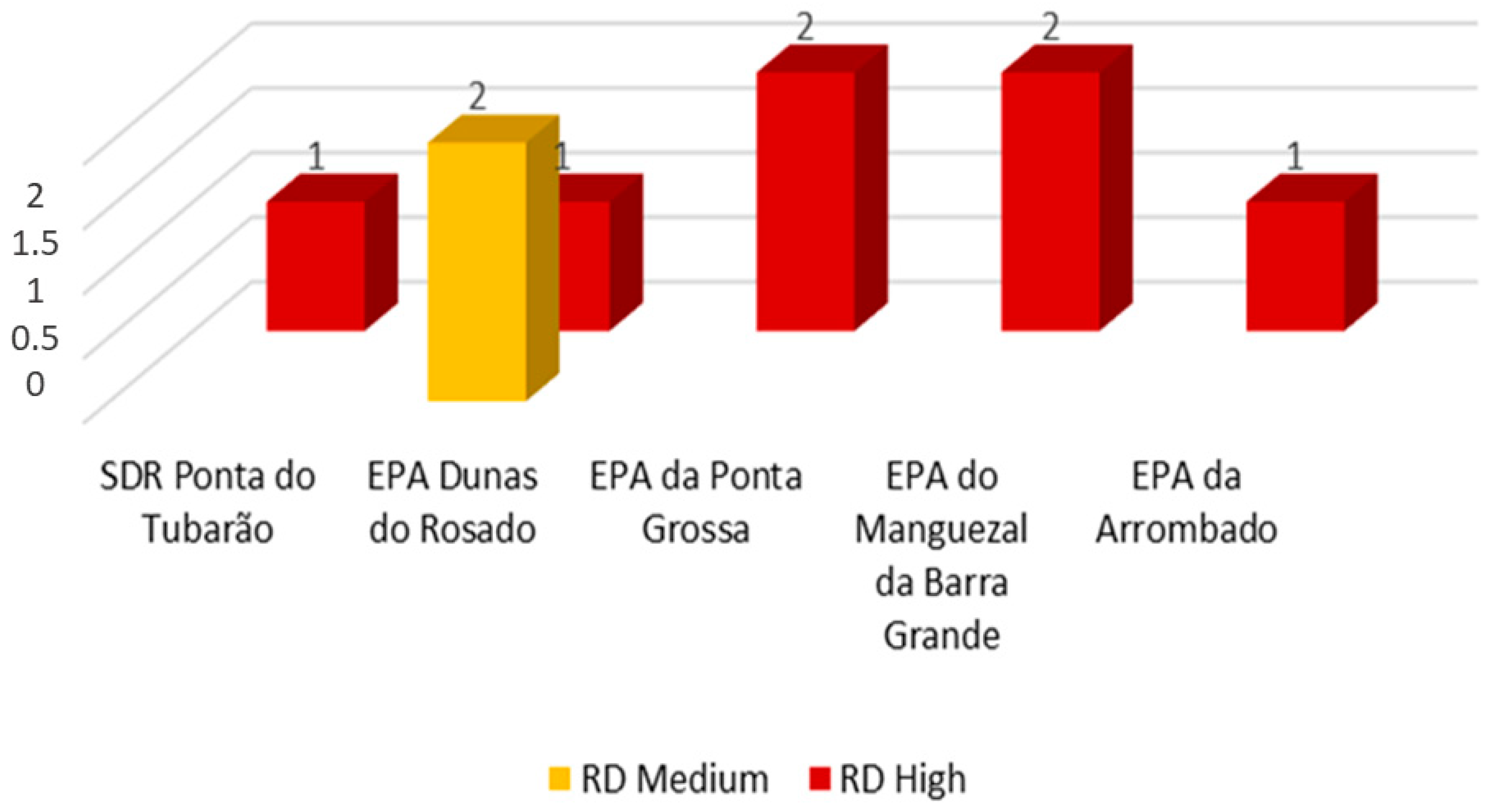
It is important to emphasize that all geosites are located in conservation units of sustainable use, according to the SNUC, in which the objective is to balance nature conservation and the sustainable use of part of its natural resources. However, in all these CU the geosites are exposed to medium and high risk of degradation (Figure 25), which should not be expected within protected areas.
The Dunas do Rosado EPA is the only protected area that has the majority of its geosites with medium scores of degradation risk, namely Rosado Cliffs and the Ponta do Mel Cliffs. This is mainly because these two geosites are in less urbanized areas and with less accessibility due to altitude and topography [58]. The other CU are all in areas where the human occupations and uses are accentuated, either due to urbanization or due to the economic potential of the region associated largely with the geodiversity of the site.
The intensification of anthropic interferences in these CU are a warning of the risk of degradation associated with man and climate change in the area linked, mainly, to the sea level signals in the semi-arid coast. The Brazilian Panel on Climate Change points out worrying changes for Brazil regarding coastal flooding and indicates that different regions of Brazil are already experiencing changes in their characteristic climates [18].
Araújo et al. [59] highlight the presence of signs of sea level rise in coastal municipalities that encompass both the Dunas do Rosado EPA and the Ponta do Tubarão SDR. The results of this research show that 16% of the study area presents high to extremely high vulnerability to tidal flooding, corresponding to 205.30 km2. Furthermore, the authors mention that flood events have become more frequent in recent years.
The geosites present in the other protected areas are also exposed to this type of consequence, enhanced by climate change (Figure 26). Aguiar et al. [21] evaluated the risk of tidal inundation due to climate change in the Apodi-Mossoró estuary, sector to the west of the Dunas do Rosado EPA and to the southeast of the Arrombado EPA and found a risk situation similar to that indicated by Araújo et al. [59]. Aguiar et al. [21] identified that flooding events can result in orders in excess of USD 147,000 and climate change scenarios show trends in increased flooding. This panorama of the coastal reality of the study area, makes the alert of extreme concern regarding the preservation of the coastal geosites pointed out.
Most of the geosites are located in areas subject to be impacted by tidal flooding, with the exception of those located at higher points. The Ponta do Mel Cliffs and Rosado Cliffs geosites, which are classified with a lower risk of degradation were not indicated as possibly impacted by the rise in tide levels because they are associated with the plateau reliefs with higher altimetric levels.
It is important to highlight that the viewpoint-type geosites obtained the highest degradation risk for having been assessed considering the areas observed from the viewpoint [57]. However, these viewpoints are not in areas susceptible to tide level rise, making anthropic vulnerability and public use criteria the main points to be considered in these sites.
The geosites located in the lowland areas are totally or partially impacted by the tidal flood forecast considering the RCP 8.5 scenario, which contributes to the increase in the natural vulnerability of these sites. It is important to emphasize that all these sites were classified with a high risk of degradation and by associating these results to the sea level rise exposure data, it is possible to state that the risk of degradation becomes even higher for these sites.
The results converge and become very worrying in the face of discussions on climate change. Extreme flooding will continue to be concentrated mainly in regions with the development of floodplains or lowland coastal zones [14,18]. However, as global warming spurs more extreme weather events, the risks extend beyond high-risk areas. Serious floods are to be expected, and in cities where they already occur, they will no longer be as sporadic but much more frequent.
For some of these geosites, such as Redonda and Perobas Beach, Picos and Vila Nova Beach, and Ponta Grossa Beach, the sea level changes associated with the human presence in the site and its different types of land use can directly impact the loss of important scientific characteristics of these sites and consequently in their aesthetic value. This information points to the relevance of the relationship between “climate change and human uses”, which intensifies the risk of geoheritage degradation in coastal areas.
This relationship in the Brazilian semi-arid coast shows that many geosites are doubly threatened, since this area presents specific characteristics of a semi-arid climate and is located in areas that, according to the IPCC [18], are more vulnerable to the occurrence of extreme climate events due to the warming of the oceans, the rise in sea level, the increase in air temperature and heat waves.
The connection between climate change and geoheritage degradation is recent [59,60,61,62,63,64]. Furthermore, apart from the work that supported our methodology [16]), we could not find others that specifically assess the degradation risk in coastal geosites due to sea level rise. The results are similar to the ones presented here, namely regarding the degradation in geosites caused by erosive processes with sea level rise. However, it is important to note that coastal erosion due to climate change sea-level rise is the subject of numerous literature studies [65,66,67,68], leading to the conclusion that, in general, coastal geosites, especially in lowland areas, are at risk, regardless of their location in the world.

4. Conclusions

The current scenario of global climate change has taken on major proportions in relation to environmental and social changes. Human interventions associated with these changes in climate corroborate a scenario of disasters and degradation risk. In this research, the geoheritage degradation risk present in the coastal conservation units of Costa Branca was assessed. In these areas, geoheritage should be protected, even more when geosites present a high risk of degradation associated mainly with human activities.
All the conservation units analyzed in this work are classified as CU of sustainable use and present clear signs of human impacts on the geoheritage, mainly through activities such as the generation of wind energy, tourism, saline exploitation activity, and the use of the area for construction. The geosites with less scientific and aesthetic value also present a high risk of degradation due to these local uses.
The assessment performed in the Costa Branca geoheritage provided a panorama of this type of coastal protected areas and draws attention to the need for the geoheritage degradation risk assessment in coastal protected areas in other parts of the world, mainly in a climate change scenario. The method used contains criteria focused on the public use of the geoheritage, which contributed to high scores obtained since all the geosites of the area are submitted directly or indirectly to human activities.
These results can be observed in connection with global climate change, which is reflected in the hazard of tidal floods in sea level rise scenarios for the semi-arid Brazilian coast. All the geosites located in plain areas are exposed to these occurrences. As extreme climate events increase, geoconservation measures must be considered in the management of coastal geoheritage.
The little knowledge by the public managers and local population about the geoheritage occurring inside the conservation units of the Brazilian semi-arid coast influences the degradation of the geosites. All the sites do not present physical barriers or visitor control and only the mangrove of Requenguela geosite has information panels.
Geoheritage degradation risk assessment is becoming increasingly important for the management of priority areas of geodiversity, especially in scenarios facing climate change where coastal environments are susceptible to these changes. The scientific and aesthetic values present in the Costa Branca geosites justify the need for a greater understanding of their risk of degradation. If the current level of degradation persists and further degradation related to climate change succeeds, not only the geoheritage is jeopardized, but also the social and economic sustainability of the area is at risk since many human activities such as tourism, salt production, and wind farms depend directly on the geodiversity features.

Author Contributions

Conceptualization, M.T.M.D. and T.O.R. Methodology, M.T.M.D.and T.O.R.; Validation, M.T.M.D., T.O.R., I.G.D.d.A., L.S.Q. and M.L.d.O.T. Investigation, M.T.M.D., T.O.R., I.G.D.d.A., L.S.Q. and M.L.d.O.T.; Data curation, T.O.R. Writing—original draft, T.O.R., I.G.D.d.A. and M.L.d.O.T.; Writing—review & editing, M.T.M.D., T.O.R., I.G.D.d.A., L.S.Q., M.L.d.O.T., P.V.d.N.A. and P.P. Supervision, M.T.M.D., P.V.d.N.A. and P.P. All authors have read and agreed to the published version of the manuscript.

Funding

This study was partially financed by the Coordenação de Aperfeiçoamento de Pessoal de Nível Superior–Brasil (CAPES)–Finance Code 001, Fundação de Amparo e Promoção da Ciência, Tecnologia e Inovação do Rio Grande do Norte (FAPERN), Conselho Nacional para o Desenvolvimento Científico e Tecnológico-Brasil (CNPq).

Data Availability Statement

Not applicable.

Acknowledgments

The authors would like to thank CAPES, FAPERN, UFRN and CAPES for funding this research. They thank CNPq for the post-doctoral fellowship of Thiara Rabelo and for the research productivity fellowship of Marco Diniz. They thank CAPES for the PhD scholarships of Maria Terto, Isa Araújo and Larissa Queiroz.

Conflicts of Interest

The authors declare no conflict of interest.

References

  1. Melillo, J.M.; Lu, X.; Kicklighter, D.W.; Reilly, J.M.; Cai, Y.; Sokolov, A.P.O. papel das áreas protegidas na mitigação das mudanças climáticas. Ambio 2016, 45, 133–145. [Google Scholar] [CrossRef]
  2. Štrba, L.; Kolačkovská, J.; Kudelas, D.; Kršák, B.; Sidor, C. Geoheritage and Geotourism Contribution to Tourism Development in Protected Areas of Slovakia—Theoretical Considerations. Sustainability 2020, 12, 2979. [Google Scholar] [CrossRef]
  3. Bruno, J.F.; Bates, A.E.; Cacciapaglia, C.; Pike, E.P.; Amstrup, S.C.; Hooidonk, R.; Henson, S.A.; Aronson, R.B. Climate change threatens the word’s marine protected areas. Nat. Clim. Change 2018, 8, 499–503. [Google Scholar]
  4. Diário Oficial da União. Lei nº 9.985, de 18 de julho de 2000; Brazilian Federal Government: Brasília, Brazil, 2000.
  5. Ogawa, F.S. Análise das Projeções de Mudanças Climáticas no Quinto Relatório do IPCC Dentro das Áreas Protegidas Brasileiras [Analysis of Climate Change Projections in the IPCC Fifth Report within Brazilian Protected Areas]. Bachelor’s Thesis, Universidade Estadual Paulista “Júlio de Mesquita”, São Paulo, Brazil, 2015. [Google Scholar]
  6. Pereira, P.J.S. Patrimônio Geomorfológico: Conceptualização, Avaliação e Divulgação. Aplicação ao Parque Natural de Montesinho [Geomorphological Heritage: Conceptualization, Evaluation and Dissemination. Application to the Natural Park of Montesinho]. Ph.D. Thesis, Universidade do Minho, Braga, Portugal, 2006. [Google Scholar]
  7. Gray, M. Geodiversity: Valuing and Conserving Abiotic Nature, 2nd ed.; John Wiley & Sons: Chichester, UK, 2013; 495p. [Google Scholar]
  8. Brilha, J. Inventory and Quantitative assessment of geosites and geodiversity sites: A review. Geoheritage 2016, 8, 119–134. [Google Scholar] [CrossRef]
  9. Meira, S.A.; Morais, J.O. Os conceitos de geodiversidade, patrimônio geológico e geoconservação: Abordagens sobre o papel da geografia no estudo da temática [The concepts of geodiversity, geological heritage and geoconservation: Approaches on the role of geography in the study of the theme]. Bol. Geogr. 2017, 11, 129–147. [Google Scholar] [CrossRef]
  10. Brilha, J. Geoheritage: Inventories and evaluation. In Geoheritage; Reynard, E., Brilha, J., Eds.; Elsevier: Chennai, India, 2018; pp. 69–85. ISBN 9780128095317. [Google Scholar]
  11. Gray, M. Geodiversity: A significant, multi-faceted and evolving, geoscientific paradigm rather than a redundant term. Proceedigns Geol. Assoc. 2021, 132, 605–619. [Google Scholar] [CrossRef]
  12. Kubalíková, L.; Irapta, P.N.; Pál, M.; Zwoliński, Z.; Coratza, P.; Van Wyk de Vries, B. Visages of Geodiversity and Geoheritage: A Multidisciplinary Approach to Valuing, Conserving and Managing Abiotic Nature; Geological Society, Special Publications: London, UK, 2023. [Google Scholar]
  13. Prosser, C.D.; Díaz-Martínez, E.; Larwood, J.G.H. Conservação de geossítios: Princípios e prática. In Geoheritage; Reynard, E., Brilha, J., Eds.; Elsevier: Chennai, India, 2018; pp. 193–221. ISBN 9780128095317. [Google Scholar]
  14. Intergovernmental Panel on Climate Change (IPCC). Climate Change 2022: Impacts, Adaptation and Vulnerability; Contribution of Working Group II to the Sixth Assessement Report of the Intergovernmental Panel on Climate Change; Pörtner, H.-O.O., Roberts, D.C., Tignor, M., Poloczanska, E.S., Mintenbeck, K., Alegría, A., Craig, M., Langsdorf, S., Löschke, S., Möller, V., et al., Eds.; Cambridge University Press: Cambridge, UK, 2023; 3056p. [Google Scholar] [CrossRef]
  15. García-Ortiz, E.; Fuertes-Gutiérrez, I.; Fernández-Martínez, E. Concepts and terminology for the risk of degradation of geological heritage sites: Fragility and natural vulnerability, a case study. Proc. Geol. Assoc. 2014, 125, 463–479. [Google Scholar] [CrossRef]
  16. Selmi, L.; Canesin, T.S.; Gauci, R.; Pereira, P.; Coratza, P. Degradation Risk Assessment: Understanding the Impacts of Climate Change on Geoheritage. Sustainability 2022, 14, 4262. [Google Scholar] [CrossRef]
  17. Sarkar, N.; Rizzo, A.; Vandelli, V.; Soldati, M. A Literature Review of Climate-Related Coastal Risks in the Mediterranean, a Climate Change Hotspot. Sustainability 2022, 14, 15994. [Google Scholar] [CrossRef]
  18. Painel Brasileiro de Mudanças Climáticas. Impacto, Vulnerabilidade e Adaptação das Cidades Costeiras Brasileiras às Mudanças Climáticas: Relatório Especial do Painel Brasileiro de Mudanças Climáticas [Impact, Vulnerability and Adaptation of Brazilian Coastal Cities to Climate Change: Special Report of the Brazilian Panel on Climate Change]; UFRJ: Rio de Janeiro, Brazil, 2016; 184p.
  19. Souto, M.V.S. Análise da Evolução Costeira do Litoral Setentrional do Estado Rio Grande do Norte, Região Sob Influência da Indústria Petrolífera [Analysis of the Coastal Evolution of the Northern Coast of Rio Grande do Norte State, a Region under the Influence of the Oil Industry]. Ph.D. Thesis, Universidade Federal do Rio Grande do Norte, Natal, Brazil, 2009. [Google Scholar]
  20. Boori, M.S. Avaliação de Impacto Ambiental e Gestão dos Recursos Naturais no Estuário Apodi Mossoró, Nordeste do Brasil [Environmental Impact Assessment and Natural Resource Management in the Apodi Mossoró Estuary, Northeastern Brazil]. Ph.D. Thesis, Universidade Federal do Rio Grande do Norte, Natal, Brazil, 2011. [Google Scholar]
  21. Aguiar, L.S.; Amaro, V.E.; Araújo, P.V.N.; Santos, A.L.S. Low Cost Geotechnology Applied to Flood Risk Assessment in Coastal Urban Areas in Climate Change Scenarios. Anuário Inst. Geociências UFRJ 2019, 42, 267–290. [Google Scholar] [CrossRef]
  22. Aguiar, L.; Amaro, V. Possíveis efeitos das mudanças climáticas no litoral do RN [Possible effects of climate change on the RN coast]. Rev. CERES 2015, 1, 108–114. [Google Scholar]
  23. Soares, M.O.; Rabelo, E.F. Primeiro registro de branqueamento de corais no litoral do Ceará (NE, Brasil): Indicador das mudanças climáticas? [First record of coral bleaching in the coast of Ceará (NE, Brazil): An indicator of climate change?]. Rev. Geociências 2006, 33, 1–10. [Google Scholar]
  24. Souza, E.B.D. Turismo, Dinâmica do Setor de Serviços e Seus Possíveis Problemas Ambientais No Litoral de Areia Branca-RN [Dynamics of the Service Sector and Its Possible Environmental Problems on the Coast of Areia Branca-RN]. Master’s Thesis, Universidade Estadual do Rio Grande do Norte, Mossoró, Brazil, 2018. [Google Scholar]
  25. Coriolano, L.N.; Pereira, M.F.S. Turismo comunitário na busca do desenvolvimento à escala humana em Icapuí, Ceará. Rev. FAEEBA Educ. Contemp. 2018, 27, 89–100. [Google Scholar] [CrossRef]
  26. Araújo, I.G.D. Geomorfodiversidade da Zona Costeira de Icapuí/CE: Definindo Geomorfossítios pelos Valores Científico e Estético [Geomorphodiversity of Icapuí/Ce Coastal Zone: Defining Geomorphosites by Scientific and Aesthetic Values]. Master’s Thesis, Universidade Federal do Rio Grande do Norte, Caicó, Brazil, 2021. [Google Scholar]
  27. Terto, M.L.O. Inventário, Quantificação e Mapeamento de Geomorfossítios a Partir da Análise de Geoformas em Tibau, Grossos e Areia Branca/RN [Inventory, Quantification and Mapping of Geomorphosites from the Analysis of Geoforms in Tibau, Grossos and Areia Branca/RN]. Master’s Thesis, Universidade Federal do Rio Grande do Norte, Natal, Brazil, 2021. [Google Scholar]
  28. Silva, F.E.B. Geopatrimônio dos Municípios de Porto do Mangue e Macau—RN [Geopatrimony of the Municipalities of Porto do Mangue and Macau—RN]. Master’s Thesis, Universidade Federal do Rio Grande do Norte, Natal, Brazil, 2021. [Google Scholar]
  29. Quesada-Valverde, M.E.; Quesada-Román, A. Worldwide trends in methods and resources promoting geoconservation, geotourism, and geoheritage. In Proceedings of the 10th IAG International Conference Geomorphology, Coimbra, Portugal, 12–16 September 2022. [Google Scholar] [CrossRef]
  30. Lopes, L.S.D. Estudo Metodológico de Avaliação do Patrimônio Geomorfológico: Aplicação no Litoral do Estado do Piauí [Methodological Study for the Evaluation of Geomorphological Heritage: Application to the Coast of Piauí State]. Ph.D. Thesis, Universidade Federal de Pernambuco, Recife, Brazil, 2017. [Google Scholar]
  31. Barros, F.M.L.; Mansur, K.L. Desafios da gestão costeira integrada da Região dos Lagos (RJ): Uma análise baseada na vulnerabilidade costeira e nos serviços ecossistêmicos da geodiversidade [Challenges of integrated coastal management in the Região dos Lagos (RJ): An analysis based on coastal vulnerability and geodiversity ecosystem services]. Rev. Bras. Geogr. IBGE 2018, 63, 73–97. [Google Scholar] [CrossRef]
  32. Santos, D.S.; Mansur, K.L.; Seoane, J.C.; Mucivuna, V.C.; Reynard, E. Methodological Proposal for the Inventory and Assessment of Geomorphosites: An Integrated Approach Focused on Territorial Management and Geoconservation. Environ. Manag. 2020, 66, 476–497. [Google Scholar] [CrossRef] [PubMed]
  33. Rabelo, T.O. Geoconservação e Risco de Degradação de Ambientes Costeiros: Uma Proposta de Avaliação do Geopatrimônio Costeiro dos Municípios de Raposa-MA e Galinhos-RN, Brasil [Geoconservation and Degradation Risk of Coastal Environments: A Proposal of Evaluation of the Coastal Geoheritage of the Municipalities of Raposa-MA and Galinhos-RN, Brazil]. Ph.D. Thesis, Universidade Federal do Rio Grande do Norte, Natal, Brazil, 2022. [Google Scholar]
  34. Diniz, M.T.M.; Terto, M.L.O.; Silva, F.E.B. Assessment of the Geomorphological Heritage of the Costa Branca Area, a Potential Geopark in Brazil. Recursos 2023, 12, 13. [Google Scholar] [CrossRef]
  35. Diniz, M.T.M.; Oliveira, G.P. Proposta de Compartimentação em microescala para o litoral do nordeste brasileiro [Microscale Compartmentalization Proposal for the Brazilian northeastern coast]. Rev. Bras. De Geomorfol. 2016, 17, 565–590. [Google Scholar] [CrossRef]
  36. Departamento Nacional de Produção Mineral. Sumário Mineral [Mineral Summary]; DNPM/DIPLAM: Rio de Janeiro, Brazil, 2014.
  37. Angelim, L.D.A.; Medeiros, V.C.; Nesi, J.R. Mapa geológico do Estado do Rio Grande do Norte; Programa Geologia do Brasil—PGB, Projeto Geologia e Recursos Minerais do Estado do Rio Grande do Norte, 1 mapa color. Scale.1:500,000; CPRM/FAPERN: Recife, Brazil, 2006.
  38. Moura-Lima, E.; Bezerra, F.H.R.; Lima-Filho, F.P.; De Castro, D.L.; Souza, M.O.L.; Fonsceca, V.P.; Aquino, M.R. 3-D geomeg1try and luminescence chronology of Quaternary soft sediment deformation structures in gravels, northeastern Brazil. Sediment. Geol. 2011, 235, 160–171. [Google Scholar] [CrossRef]
  39. Diniz, M.T.M.; Araújo, I.G.D.; Chagas, M.D. Comparative study of quantitative assessment of the geomorphological heritage of the coastal zone of Icapuí—Ceará, Brazil. Int. J. Geoheritage Park 2022, 10, 124–142. [Google Scholar] [CrossRef]
  40. Matos, R.M.D. Tectonic evolution of the Equatorial South Atlantic. Am. Geophys. Union 2000, 115, 331–354. [Google Scholar]
  41. Matos, R.M.D. The Northeast Brazilian Rift System. Tectonics 1992, 11, 766–791. [Google Scholar] [CrossRef]
  42. Maia, R.P.; Bezerra, H.H.R. Conditioning structural of relief in Northeast Brazilian. Mercator 2014, 13, 121–141, ISSN 1984-2201. [Google Scholar] [CrossRef]
  43. Chang, H.K.; Kowsmann, R.O.; Figueiredo, A.M.F. New concepts on the on the developpment of East Brazilian marginal basins. Episodes 1988, 2, 194–202. [Google Scholar] [CrossRef]
  44. Sousa, D.C. Litoestratigrafia e Deformação Cenozoica na Região de Icapuí, Ceará, e Implicações Para a Estruturação de Campos de Petróleo na Borda Ocidental da Bacia Potiguar (NE do Brasil) [Lithostratigraphy and Cenozoic Deformation in the Icapuí Region, Ceará, and Implications for Oil Field Structuring in the Western Border of the Potiguar Basin (NE Brazil)]. Ph.D. Thesis, Universidade Federal do Rio Grande do Norte, Natal, Brazil, 2003. [Google Scholar]
  45. Neto, C.A.; Junior, D.R.N.; Duarte, C.R.; Freires, E.V.; Oliveira, K.M.L. A new method for evaluating the spatial correspondence between surface and subsurface geological lineaments: A case from the Potiguar Basin, NE Brazil. J. S. Am. Earth Sci. 2022, 119, 104026. [Google Scholar] [CrossRef]
  46. Souza, D.C.; Jardim de Sá, E.F.; Antunes, A.F. Deformação neógena e suas implicações na estruturação dos campos de petróleo na região de Icapuí-Ponta Grossa (CE), Bacia Potiguar emersa. Rev. Bras. Geociências 2008, 38, 97–110. [Google Scholar] [CrossRef]
  47. Sousa, D.C.; Jardim De Sá, E.F.; Vital, H.; Nascimento, M.A.L. Falésias na Praia de Ponta Grossa, Icapuí, CE—Importantes deformações tectônicas cenozoicas em rochas sedimentares da Formação Barreiras. In Sítios Geológicos e Paleontológicos do Brasil [Geological and Paleontological Sites of Brazil], 2nd ed.; Winge, M., Schobbenhaus, C., Souza, C.R.G., Fernandes, A.C.S., Berbertborn, M., Queiroz, E.T., Eds.; CPRM: Rio de Janeiro, Brazil, 2009; pp. 501–512. [Google Scholar]
  48. Meireles, A.J.A.; Arruda, M.G.C.; Gorayebe, A.; Thiers, P.R.L. Integração dos indicadores geoambientais de flutuação do nível relativo do mar e de mudanças climáticas no litoral cearense [Integration of geoenvironmental indicators of relative sea level fluctuation and climate change on the coast of Ceará]. Mercator 2005, 4, 109–134. [Google Scholar]
  49. Meireles, A.J.A.; Santos, A.M.F.D. Evolução geomorfológica da planície costeira de Icapuí, extremo leste do Ceará, nordeste do Brasil [Geomorphological evolution of the coastal plain of Icapuí, extreme east of Ceará, northeastern Brazil]. Geografia 2011, 36, 519–534. [Google Scholar]
  50. Maia, R.P. Geomorfologia e Neotectônica no Vale do Rio Apodi-Mossoró NE/Brasil [Geomorphology and Neotectonics in the Apodi River Valley-Mossoró NE/Brazil]. Ph.D. Thesis, Universidade Federal do Rio Grande do Norte, Natal, Brazil, 2012. [Google Scholar]
  51. Barbosa, M.E.F.; Boski, T.; Bezerra, F.H.; Lima-Filho, F.P.; Gomes, M.P.; Pereira, L.C.; Maia, R.P. Late Quaternary infilling of the Assu River embayment and related sea level changes in NE Brazil. Mar. Geol. 2018, 405, 23–37. [Google Scholar] [CrossRef]
  52. Bezerra, F.H.; Castro, D.L.; Maia, R.P.; Souza, M.O.L.; Moura-Lima, E.N.; Rosseti, D.F.; Bertotti, G.; Souza, Z.S.; Nogueira, F.C.C. Postrift stress field inversion in the Potiguar Basin, Brazil—Implications for petroleum systems and evolution of the equatorial margin of South America. Mar. Pet. Geol. 2020, 111, 88–104. [Google Scholar] [CrossRef]
  53. Vital, H.; Santos, N.F.; Plácido, J.S., Jr. Morphodynamic of a Tropical Tidal Inlet: Case Study on the Rio Grande do Norte Coast, Northeast Brazil. J. Int. Coast. Zone Manag. 2008, 8, 113–126. [Google Scholar]
  54. Wang, L.; Qiu, Y.; Han, Z.; Xu, C.; Wu, S.Y.; Wang, Y.; Holmgren, M.; Xu, Z. Climate, topography and anthropogenic effects on desert greening: A 40-year satellite monitoring in the Tengger desert, northern China. Catena 2021, 209 Pt 2, 105851. [Google Scholar] [CrossRef]
  55. Jackson, D.W.; Costas, S.; González-Villanueva, R.; Cooper, A. A global ‘greening’ of coastal dunes: An integrated consequence of climate change? Glob. Planet. Change 2019, 182, 103026. [Google Scholar] [CrossRef]
  56. Mikhailenko, A.V.; Ruban, D.A. Environment of Viewpoint Geosites: Evidence from the Western Caucasus. Land 2019, 8, 93. [Google Scholar] [CrossRef]
  57. Mikhailenko, A.V.; Ruban, D.A.; Ermolaev, V.A. Accessibility of Geoheritage Sites—A Methodological Proposal. Heritage 2021, 4, 1080–1091. [Google Scholar] [CrossRef]
  58. Diniz, M.T.M.; de Araújo, I.G.D. Proposal of a Quantitative Assessment Method for Viewpoint Geosites. Resources 2022, 11, 115. [Google Scholar] [CrossRef]
  59. Araújo, P.V.N.; Amaro, V.E.; Aguiar, L.S.; Lima, C.C.; Lopes, A.B. Tidal flood area mapping in the face of climate change scenarios: Case study in a tropical estuary in the Brazilian semi-arid region. Nat. Hazards Earth Syst. Sci. 2021, 21, 3353–3366. [Google Scholar] [CrossRef]
  60. Prosser, C.; Burek, C.; Evans, D.; Gordon, J.E.; Kirkbride, V.; Rennie, A.; Walmsley, C. Conserving geodiversity sites in a changing climate: Management challenges and responses. Geoheritage 2010, 2, 123–136. [Google Scholar] [CrossRef]
  61. Sharples, C. Potential Climate Change Impacts on Geodiversity in the Tasmanian Wilderness World Heritage Area: A Management Response Position Paper; Nature Conservation Report Series 11/04; Resource Management and Conservation Division, Department of Primary Industries Parks Water and Environment: Hobart, TAS, Australia, 2011.
  62. Wignall, R.; Gordon, J.E.; Brazier, V.; MacFadyen, C.; Everett, N. A qualitative risk assessment for the impacts of climate change on nationally and internationally important geoheritage sites in Scotland. Proc. Geol. Assoc. 2018, 129, 120–134. [Google Scholar] [CrossRef]
  63. Berred, S.; Berred, K. Climate change issues, challenges, and impacts in terms of rural geo-biological and cultural tourism activity development in semiarid areas: A case study from Tata, Bani Geopark (Anti-Atlas, South Morocco). Geoheritage 2021, 13, 110. [Google Scholar] [CrossRef]
  64. Gordon, J.E.; Tormey, D.; Wignall, R.; Brazier, V.; Crofts, R. Climate change will challenge the management of geoheritage in protected and conserved areas. Parks Steward. Forum 2022, 38, 56–64. [Google Scholar] [CrossRef]
  65. Gordon, J.E.; Wignall, R.; Brazier, V.; Crofts, R.; Tormey, D. Planning for Climate Change Impacts on Geoheritage Interests in Protected and Conserved Areas. Geoheritage 2022, 14, 126. [Google Scholar] [CrossRef]
  66. Zhang, K.; Douglas, B.; Leatherman, S. Global warming and coastal erosion. Clim. Change 2004, 64, 41–58. [Google Scholar] [CrossRef]
  67. Nicholls, R.; Lowe, J. Benefits of mitigation of climate change for coastal areas. Glob. Environ. Change 2004, 14, 229–244. [Google Scholar] [CrossRef]
  68. Toimil, A.; Losada, J.; Nicholls, R.; Dalrymple, R.; Stive, M. Addressing the challenges of climate change risks and adaptation in coastal areas: A review. Coast. Eng. 2020, 156, 103611. [Google Scholar] [CrossRef]
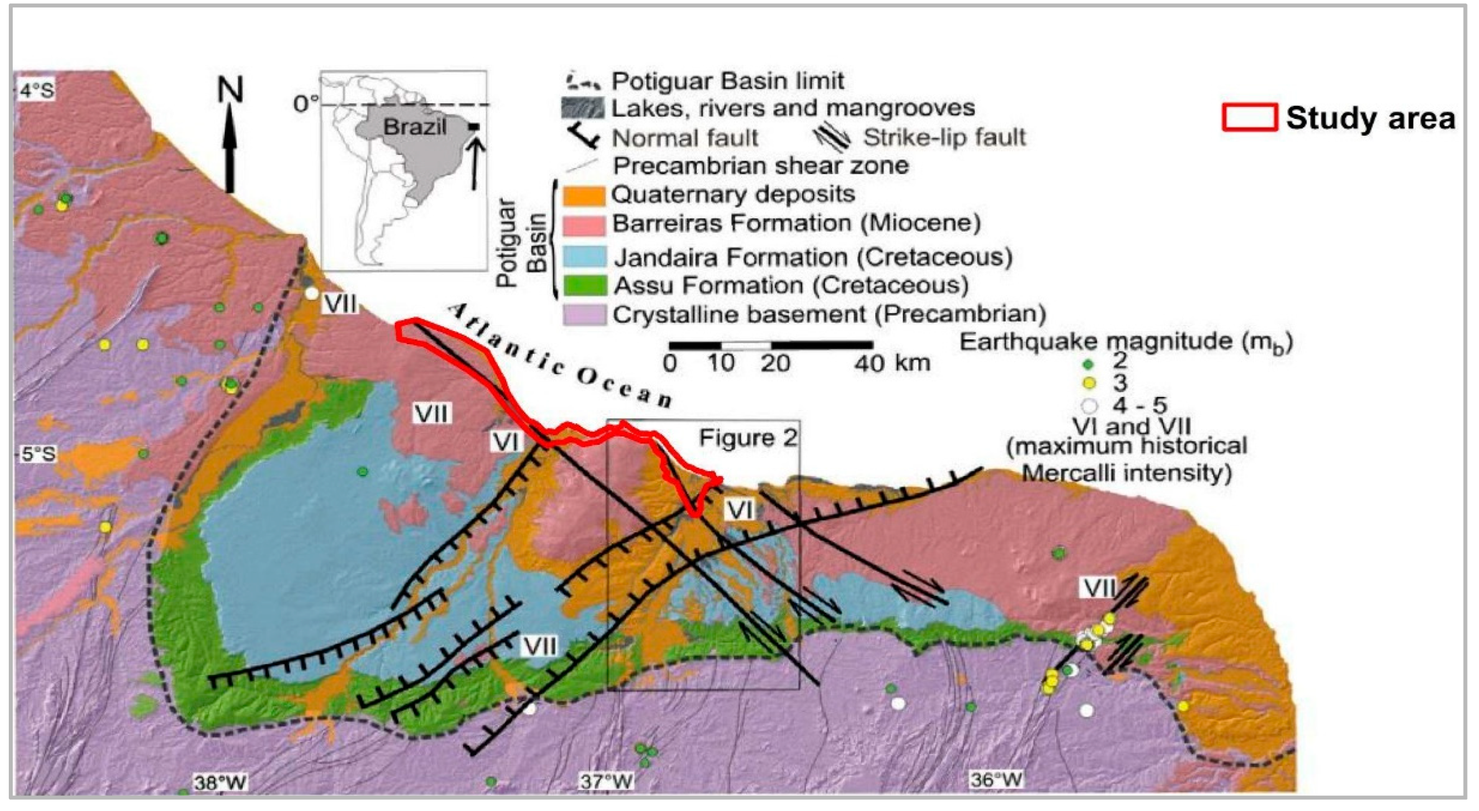
Figure 1. Geotectonic setting of the study area in the Potiguar Basin, NE Brazil. Modified from Angelim et al. [37] and Moura-Lima et al. [38].
Water 15 02564 g001
Figure 2. Location of geosites and Conservation Units (Protected Areas) inventoried in Costa Branca, semi-arid coast of Brazil. (A) Brazil; (B) Rio Grande do Norte; (C) Study area. The lithologies occurring in the Costa Branca are related to the genesis of the Potiguar Basin (Figure 1), which is characterized as a marginal type, narrowing on the eastern side and widening on the western side of the platform, as well as having associations with magmatic and sedimentary events in southern and northern Brazil. This configuration developed between 225 and 160 Ma with the separation of the Pangea supercontinent and with the deformations associated with the opening of the South Atlantic Ocean [40].
Water 15 02564 g002
Figure 3. Lithostratigraphy of the Icapuí cliffs, Ceará, Brazil. Adapted from Sousa [44].
Water 15 02564 g003
Figure 4. Retirinho geosite, where an open valley was formed by a river that no longer exists, currently occupied by a summer house: (A)-Cliffs in siliciclastic rocks of Barreiras, Potengi, and Tibau formations; (B)-Lithostratigraphy of the cliffs of Icapuí, Ceará, Brazil [44].
Water 15 02564 g004
Figure 5. Granitic boulder of almost 2 m in diameter in the Barreiras Formation, in Retirinho geosite.
Water 15 02564 g005
Figure 6. Ponta Grossa geosite, with high and low coast sections shaped in the Barreiras and Pontegi formations and Holocene marine terraces.
Water 15 02564 g006
Figure 7. Mushroom Rock landform at Picos Beach in 2020 (A) and in 2023 (B).
Water 15 02564 g007
Figure 8. Vila Nova Beach. The colored lines illustrate the Cenozoic tectonic deformation in the facies of the Barreiras Formation.
Water 15 02564 g008
Figure 9. Requenguela Beach geosite, where an ebb tide delta type occurs.
Water 15 02564 g009
Figure 10. Manibu Beach geosite, a typical example of a linear sandy beach.
Water 15 02564 g010
Figure 11. Ponta do Mel Geosite: (A) Inactive cliffs; (B) Semifixed dunes.
Water 15 02564 g011
Figure 12. Deposits of the Barreiras Formation in Serra do Mel. Modified from [50].
Water 15 02564 g012
Figure 13. Aerial view of the Rosado Dunes geosite, with the dunes containing a mixture of reddish and lighter sands.
Water 15 02564 g013
Figure 14. Ponta do Tubarão geosite.
Water 15 02564 g014
Figure 15. Rosado fossil cliffs highlighted in yellow (A) and Ponta do Mel fossil cliffs (B), the two geosites with the lowest scores regarding natural vulnerability criteria assessment.
Water 15 02564 g015
Figure 16. Barchanoid-type mobile dunes of the Rosado dune field with reddish coloration (A); Prosopis juliflora (Sw) DC forest occupying the marine terraces (B); Wind turbines on the outskirts of the Rosado Dunes geosite (C).
Water 15 02564 g016
Figure 17. Water drainage structure on a cliff at the Retirinho geosite (A); Remains of tyres left near the base of the cliffs, possibly used as fishing traps (B).
Water 15 02564 g017
Figure 18. Human presence in the Requenguela Beach (A) and Manibu Beach (B) geosites.
Water 15 02564 g018
Figure 19. Panoramic view from the Mirante da Serra do Mar geosite.
Water 15 02564 g019
Figure 20. Human occupations and coastal retaining wall in the Picos and Vila Nova beaches geosite.
Water 15 02564 g020
Figure 21. Aerial view of the Icapuí viewpoint (A). Panoramic view of the terraces surrounding the Icapuí viewpoint, observed from there (B).
Water 15 02564 g021
Figure 22. Buildings near the cliffs of the Picos and Vila Novas Beach geosites.
Water 15 02564 g022
Figure 23. Ponta Grossa Beach geosite, with yellow arrows indicating dune landslides.
Water 15 02564 g023
Figure 24. Advance of urbanization in the Ponta do Tubarão estuary geosite.
Water 15 02564 g024
Figure 25. Geoheritage degradation risk in the protected areas (CU) of Costa Branca, Brazil.
Water 15 02564 g025
Figure 26. Impacted and non-impacted areas by the tidal flood hazard under the IPCC RCP 8.5 scenario, in the conservation units of Costa Branca, Brazil.
Water 15 02564 g026
Table 1. Concepts related to geoheritage degradation risk [11,12].
ConceptDefinition
Natural vulnerabilityThe sensitivity of a geosite to being damaged or destroyed by natural processes not involved in its creation.
Anthropogenic VulnerabilityThe sensitivity of a geosite to be damaged or destroyed by human activities related to its economic value due to its geological characteristics (mining, quarrying, collecting, etc.).
Public useThe susceptibility of a geosite to damage due to its location and its current or possible use (vandalism, lack of access control, lack of physical protection, etc.).
FragilityThe sensitivity of a geosite to damage by processes involved in its creation and directly related to its geological characteristics.
Table 2. Main characteristics of the geoheritage in the conservation units of Costa Branca, Brazil [26,27,28].
CU NameLocationLaw/Creation DecreeMain Characteristics of Geoheritage
EPA Dunas do RosadoMunicipality of Porto do Mangue
(Rio Grande do Norte)
Decree n°. 27,695 of 21 February 2018Area of relevant geological interest with geomorphologic prominence with the presence of cliffs, dunes, estuaries, domes, hypersaline deserts, and areas of magmatism.
SDR Ponta do TubarãoMunicipality of Macau and Guamaré
(Rio Grande do Norte)
State Law n° 8.349 of 18 July 2003Area of relevant geomorphological interest, mainly due to the presence of a complex estuarine system Ponta do Tubarão with fluvial-marine depositions that occur in the geoforms of spit, barrier island, sandbars, and beaches.
EPA da Ponta GrossaMunicipality of Icapuí (Ceará)Municipal Law n° 262/98 of 8 April 1998Area of relevant geomorphologic interest with emphasis on the presence of escarpments, boarders, mobile dunes, viewpoints, beaches, sandy banks, and paleocliffs.
EPA do Manguezal da Barra GrandeMunicipality of Icapuí (Ceará)Municipal Law No. 634/14 of 25 February 2014An area with relevant geomorphological interest due to the presence of the Barra Grande estuarine system, estuarine plains, estuary, and marine terraces.
EPA Berçários da Vida MarinhaMunicipality of Icapuí (Ceará)Municipal Law No. 890/2021 of 15 December 2021An area of relevant geomorphologic interest, with an emphasis on the presence of escarpments, tableland, mobile dunes, viewpoints, beaches, and sandy banks.
Table 3. Criteria, parameters, indicators, and points used for the quantitative assessment of the risk of geosite degradation. Adapted from Selmi et al. [16].
CriteriaSub-CriteriaIndicatorsPoints
Natural
Vulnerability
Active
processes
No active processes affect the geosite0
One active process affects the geosite episodically1
One active process affects the geosite continuously or seasonally2
Two or more active processes affect the geosite3
ProximityNo possibility of degradation0
One possible active process in proximity of the geosite1
Two possible active processes in proximity of the geosite2
More than two active processes in proximity of the geosite3
Anthropogenic
Vulnerability
Economic interestNo geodiversity elements of economic interest0
The geosite has an element of geodiversity of economic interest1
The geosite has two elements of geodiversity of economic interest2
The geosite has more than two elements of geodiversity of economic interest3
Private InterestNo geodiversity elements of private interest0
The geosite has a collectible element of geodiversity for private interest1
The geosite has two collectible geodiversity elements of private interest2
The geosite has more than two elements of geodiversity collectible for private interest3
Public UseLegal
protection
The geosite is protected for its geoheritage0
The geosite is inside a protected natural area1
The geosite is inside an area protected for other values (historical, cultural, etc.)2
The geosite is not in a protected area3
Human proximityThe geosite is located less than 100 m from a potential degradation activity3
The geosite is located less than 500 m from a potential degradation activity2
The geosite is located less than 1 km from a potential degradation activity1
The geosite is located more than 1 km from a potential degradation activity0
AccessibilityThe geosite is located less than 100 m from a paved road and bus parking space3
The geosite is located less than 100 m from a paved road2
The geosite is located less than 100 m from a gravel road or between 100 and 500 m from a paved road1
The geosite is located more than 100 m from a gravel road or more than 500 m from a paved road/no direct access0
Population densityThe geosite is not located near human occupation0
The geosite is located in a village or town in the rural area of a city1
The geosite is located in the urban area of a city2
The geosite is located in a city considered to be a regional center3
Physical
protection
Geosite has no protection3
Geosite with structure for tourists, but without physical protection of the geoheritage2
Geosite with physical protection but without structure for tourists1
Geosite with physical protection of geoheritage features and structure for tourists0
Degrading useNo degradation from public use0
One element of degradation1
Two elements of degradation2
More than two elements of degradation3
Control of
access
No control at all3
The geosite is monitored by one method of control2
The geosite is monitored by two methods of control1
the geosite is monitored by more than two methods of control0
Table 4. Classification of the risk of degradation of geosites: partial and total scores; risk level [12].
CriteriaPartial ScoreTotal ScoreTotal Score on Degradation RiskRisk Level
Natural Vulnerability0–60–330–7low
Anthropogenic Vulnerability0–6>7 ≤ 15medium
Public Use0–21>15 ≤ 25high
>25Very high
Table 5. Results of the quantitative assessment of the risk of degradation of the Costa Branca geosites.
GeositeSTATENatural VulnerabilityAnthropic VulnerabilityPublic UseRisk of Degradation
A1A2TotalB1B2TotalC1C2C3C4C5C6C7Total
Ponta do Tubarão estuaryRN01130313313331721
Rosado CliffsRN20210112213031215
Dunas do RosadoRN21310112213031216
Ponta do Mel cliffsRN0111001011203810
Retirinho siteCE30310110113331216
Ponta Grossa beachCE30310113313331721
Redonda/Peroba beachsCE20210113313331720
Picos/Vila Nova beachsCE30310113313331721
Serra do Mar viewpointCE00010113323331819
Requenguela beachCE00020213313231618
Icapuí viewpointCE00020213323331820
Manibu beachCE01100013313331718
Note(s): Acronyms: A1: Active processes/A2: Proximity/B1: Economic interest/B2: Private Interest/C1: Legal protection/C2: Human Proximity/C3: Accessibility/C4: Population Density/C5: Physical Protection/C6: Degrading use/C7: Access Control; Risk of Degradation: Medium Water 15 02564 i001; High Water 15 02564 i002.
Table 6. Scientific value, aesthetic value, and degradation risk assessment results for the geoheritage of Costa Branca, Brazil.
GeositeScientific Value 1Aesthetic Value 1Risk of Degradation
Ponta do Tubarão estuary251621
Rosado Cliffs251715
Dunas do Rosado241616
Ponta do Mel cliffs221710
Retirinho site261216
Ponta Grossa beach251921
Redonda/Peroba beachs241220
Picos/Vila Nova beachs241621
Serra do Mar viewpoint171519
Requenguela beach251618
Icapuí viewpoint171520
Manibu beach19918
Note(s): 1 According to [34,39]. Water 15 02564 i003 Medium; Water 15 02564 i004 High.
Disclaimer/Publisher’s Note: The statements, opinions and data contained in all publications are solely those of the individual author(s) and contributor(s) and not of MDPI and/or the editor(s). MDPI and/or the editor(s) disclaim responsibility for any injury to people or property resulting from any ideas, methods, instructions or products referred to in the content.