Article

Temporal and Spatial Analysis of Water Resources under the Influence of Coal Mining: A Case Study of Yangquan Basin, China

1
College of Marine Sciences, Shanghai Ocean University, Shanghai 201308, China
2
Research Center on Flood and Drought Disaster Reduction, Institute of Water Resources and Hydropower Research, Beijing 100038, China
3
School of Public Security, People’s Public Security University of China, Beijing 100038, China
4
College of Water Resources, North China University of Water Resources and Electric Power, Zhengzhou 450046, China
5
College of Hydrology and Water Resources, Hohai University, Nanjing 210098, China
*
Author to whom correspondence should be addressed.
Water 2023, 15(17), 3058; https://doi.org/10.3390/w15173058
Submission received: 31 May 2023 / Revised: 6 August 2023 / Accepted: 21 August 2023 / Published: 27 August 2023
(This article belongs to the Section Hydrology)

Abstract

:
The activities of coal mining often lead to the formation of underlying runoff areas and have great impacts on both the basin hydrological cycle and water resource management. In order to investigate the changes in the hydrological processes of the coal goaf catchment, this paper analyzes and explores the coal mining influences on the hydrological processes in a small watershed in the Yangquan Basin of China. To disentangle the mining process, a distributed hydrological model, which highlighted the integration of sub-hydrological processes, was developed and implemented in the study area. The calibration and validation results indicated that the developed model simulated streamflow well. This was indicated by the Nash–Sutcliffe model efficiency (NS) and the Coefficient of Correlation (r2) for monthly runoff. The model was first calibrated in the period of 1990–2004 and then validated in the period of 2005–2018. Different scenarios were simulated and cross-compared in order to study the mining effects; the rainfall and runoff of each hydrological station are positively correlated in 2009–2018, and the scenario of change in mining area is negatively correlated with runoff in 2009–2018. The contribution of the changing input variables (rainfall and coal mining area) to the runoff of the Yangquan Basin was analyzed qualitatively and quantitatively; the impact contribution rates of mining activities are 85.96% and 39.34% during the mining and recovery periods in Yangquan station, respectively. The hydrological simulations provided a better understanding of runoff changes in the Yangquan Basin. The analysis results indicate that the hydrologic response to the mining process in Yangquan Basin is changing, and it thus draws attention to other mining places over the world. Methods used in this study can be applied in other regions to orientate the policy-making process.

1. Introduction

A long-term unsustainable and unscientific coal mining activity is one of the main driving factors leading to the loss of water resources in the catchment. By changing the land use distribution and the geological structures in the catchment, the coal mining goaf creates an extra water passage that connects the land surface and the subsoil layer [1,2]. As a result, more surface water will infiltrate into soils, and the total runoff at the catchment outlet will be strongly decreased. Therefore, in a water-poor area such as the Shanxi province in China, the local stakeholders are eager to have an integrated method for analyzing coal mining impacts on hydrological processes [3,4].
To investigate coal mining impacts on hydrological processes, Knighton et al. mainly focused on streamflow simulation under a variable geological and coal mining policy [5,6,7,8]. Wei et al. [4] used a combination analysis of an empirical formula and a fitting formula to find the influences of coal mining on shallow water resources and produced a water resource leakage differentiation graph for the Shennan mining area based on a geological map and soil layer group thickness chart. Similarly, Jiang et al. [9] established the Yellow River Water Balance model (YRWBM) and proved that coal mining is an important reason for the runoff change in the study river. Wu et al. [10] applied the SWAT mode to quantitatively identify the changes in river runoff caused by coal mining impacts in the catchment. Tang et al. [11] summarized the research on the influence of coal mining on small-scale floods in recent years and found that the flood simulation accuracy of the study area, covered by goaf, can be improved by tuning the model parameters. The existing research has proven that coal mining activities have important impacts on catchment water resources. However, a long-term hydrological modeling analysis of the catchment under coal mining impacts is still unclear [12,13].
Among different modeling approaches, the distributed hydrological model has been commonly considered an effective modeling tool for investigating and understanding the hydrological processes in the coal mining catchment. Compared with the traditional modeling method, the distributed modeling method in this study can improve the efficiency and accuracy of modeling; therefore, it is important to transform from traditional modeling to modular modeling [14]. Previous modeling applications have laid the foundation for this study. For instance, (i) the Xin’anjing model [15,16] can realize the continuous simulation of rainfall and runoff and is mainly used in semi-humid and humid regions, (ii) the distributed Geomorphology-Based Hydrological Model (GBHM) includes two main simulated hydrological processes: hydrological simulation at each hillslope and river routing in the river network [17,18], (iii) the precipitation-runoff modeling system (PRMS) developed by the United States Geological Survey that can evaluate the impacts of various hydrological units [12], and (iv) the spatiotemporal variable source mixed runoff (SVSMR) model proposed by Liu et al. [19], which considers the unsaturated soil infiltration process on different geomorphological hydrological response units, analyzes the main parameter characteristics of different soil types and also revealed the characteristics of the underlying surface and rainfall–runoff generation in a small watershed.
Shanxi province is located in the middle part of China, and around 60% of the province area has been characterized as a water shortage area that lacks irrigation and drinking water resources [20]. As a typical coal mining province in China, among 118 county and city administrative units in the province, there are 94 countries and cities identified as rich coal resource areas. Under current conditions, the loss and pollution of available water resources in Shanxi province are becoming more serious [21,22,23].
This paper aims to apply an improved modeling approach to simulate the variation of surface runoff in relation to changes in meteorological and geological conditions. Choosing the Yangquan catchment (485 km2) located in the eastern part of Shanxi as the study area [24], this paper presents (1) a modification of the existing SVSMR model, (2) test scenario results to show how the new model performs with variation in rainfall and mining in the affected area, and (3) discussion of rainfall/runoff results from the new model for the Yangquan catchment.

2. Materials and Methods

2.1. Study Area

The Yangquan Basin (485 km2) is located in the eastern part of Shanxi province. There are two runoff gage stations in this basin—Yangquan and Jiujie. As a result of the coal mining activities in Shanxi province, the coal goaf-impacted area in this basin is around 108.2 km2, which accounts for 21.5% of the total area [17]. Using ENVI (Environment for Visualizing Images), land use patterns were interpreted from 2.5 m resolution image classification [25]. The main type of land use is pasture land, which accounts for 68.6%, and the minimum type of land use is water area, which accounts for 1.2% of the total study area (Figure 1).
The catchment climate follows the inland plateau and warm temperate monsoon climate. Air temperature decreases in the fall, and so does rainfall. The cold air activity in winter is frequent, with a cold and dry climate, and the weather is sunny; meanwhile, precipitation is scarce. The average annual temperature from 1958 to 2012 in Shanxi Province was 8.6 °C, the highest value was 10.2 °C, and the lowest value was 7.4 °C; the overall trend shows a significant increase in fluctuation [26].
The catchment topography was derived from the Geospatial data cloud website within a 25 m spatial resolution [27]; the river network extends over approximately 208.85 km.
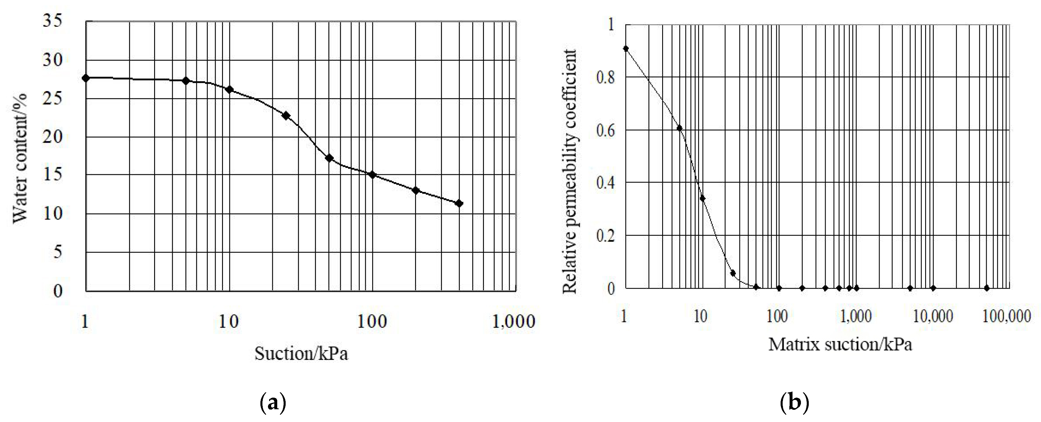
The soil distribution was obtained through field soil exploration and a survey combined with the second national soil census in China [28]: the loam accounts for 66.7%, the clay accounts for 32.5%, and the remaining 0.8% is sandy soil. Experiments on soil and water characteristics in the Yangquan Basin were also performed, and we obtained the soil water characteristic curve shown in Figure 2.
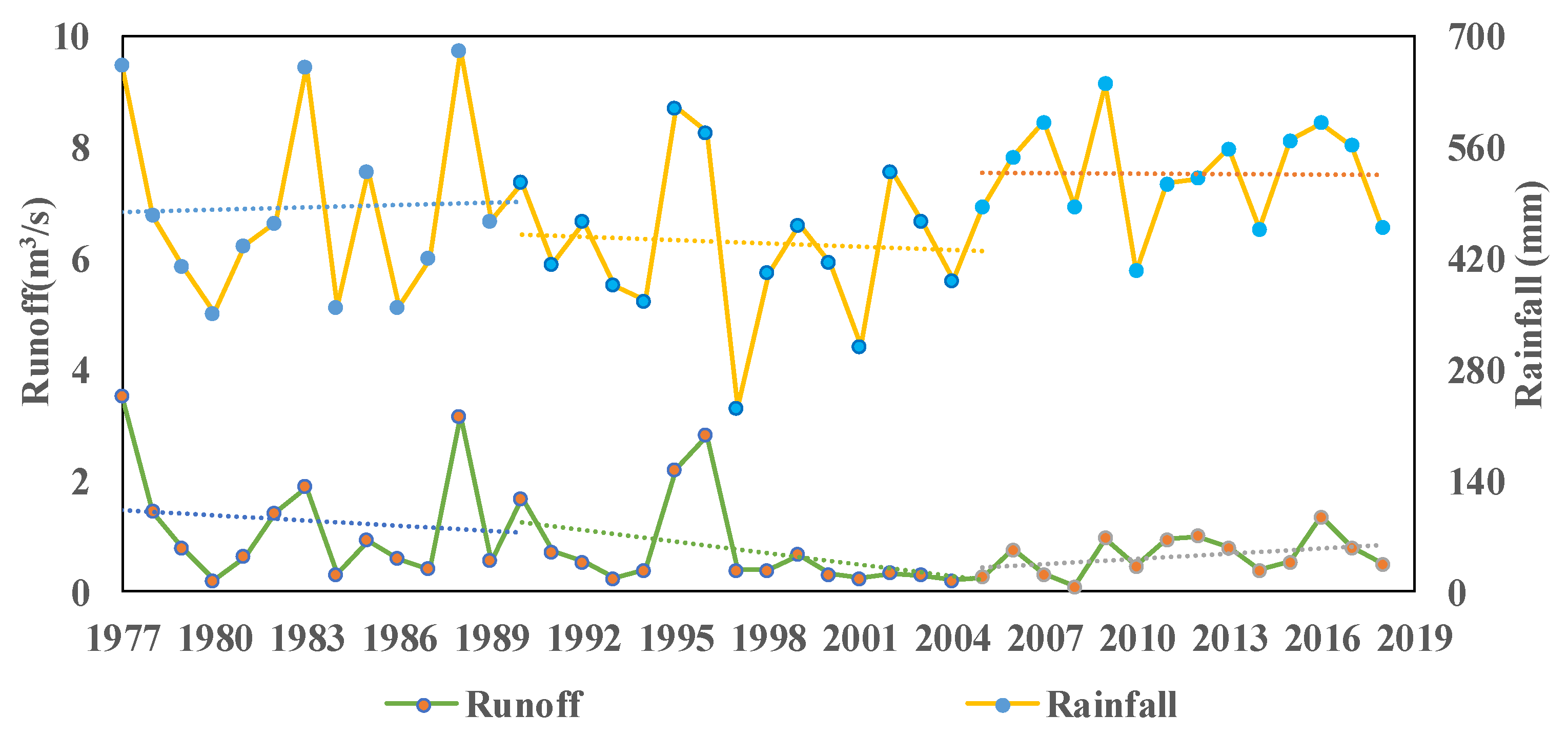
Supported by the Shanxi Hydrological Bureau, we collected the two hydrological stations’ daily rainfall and runoff for the period of 1977–2018 in this study. A simple trend analysis was conducted for both variables, as shown in Figure 3. The changing trends of daily rainfall and runoff exhibited some similarities during the periods of 1977–1990 and 2005–2019. However, the reasons for the abrupt change observed between 1991 and 2005 remain unclear. Apart from the influence of rainfall, surface runoff may also be affected by other factors, such as coal mining [29,30].
To investigate whether coal mining has an impact on surface runoff, additional data were sought in this study. The available data indicate that coal mining activity in the Yangquan Basin has been booming since 1990, resulting in a series of changes in the underlying surface. After 2005, due to the state control of coal mining activities, the development of goaf became stable [31]. Combining daily rainfall and runoff trends, and considering the existing data, the inflection point of the hydrological series, the mining time, and the gradual change in the underlying surface, the total research period is divided into three sequential subperiods. The period of 1977–1990 is regarded as a natural state, called the natural period; 1991–2018 is called the period of change, in which 1991–2004 is called the first stage of the change period, and 2005–2018 is called the second phase of the change period. The characteristics of different periods in the Yangquan Basin are shown in Table 1.

2.2. Modeling Approach

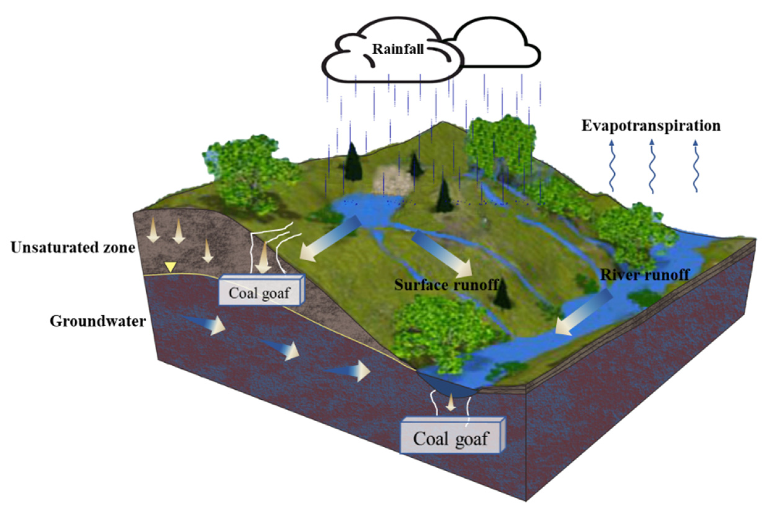
Coal mining activities often generate coal goaf in the catchment, which may increase the surface and subsurface water exchange process (Figure 4). When the rainfall–runoff process occurs in the catchment, more rainfall infiltrates into soils; thus, less surface runoff flows to the catchment outlet. Moreover, during a flood event, as more stream water may flow into the coal goaf through the crack below the riverbed, the flood peak could obviously be reduced. In order to represent the impacts of the coal goaf on the rainfall–runoff process of the catchment, an improved modeling approach based on the SVSMR model proposed by Liu et al. has been designed [19].

2.2.1. SVSMR Model

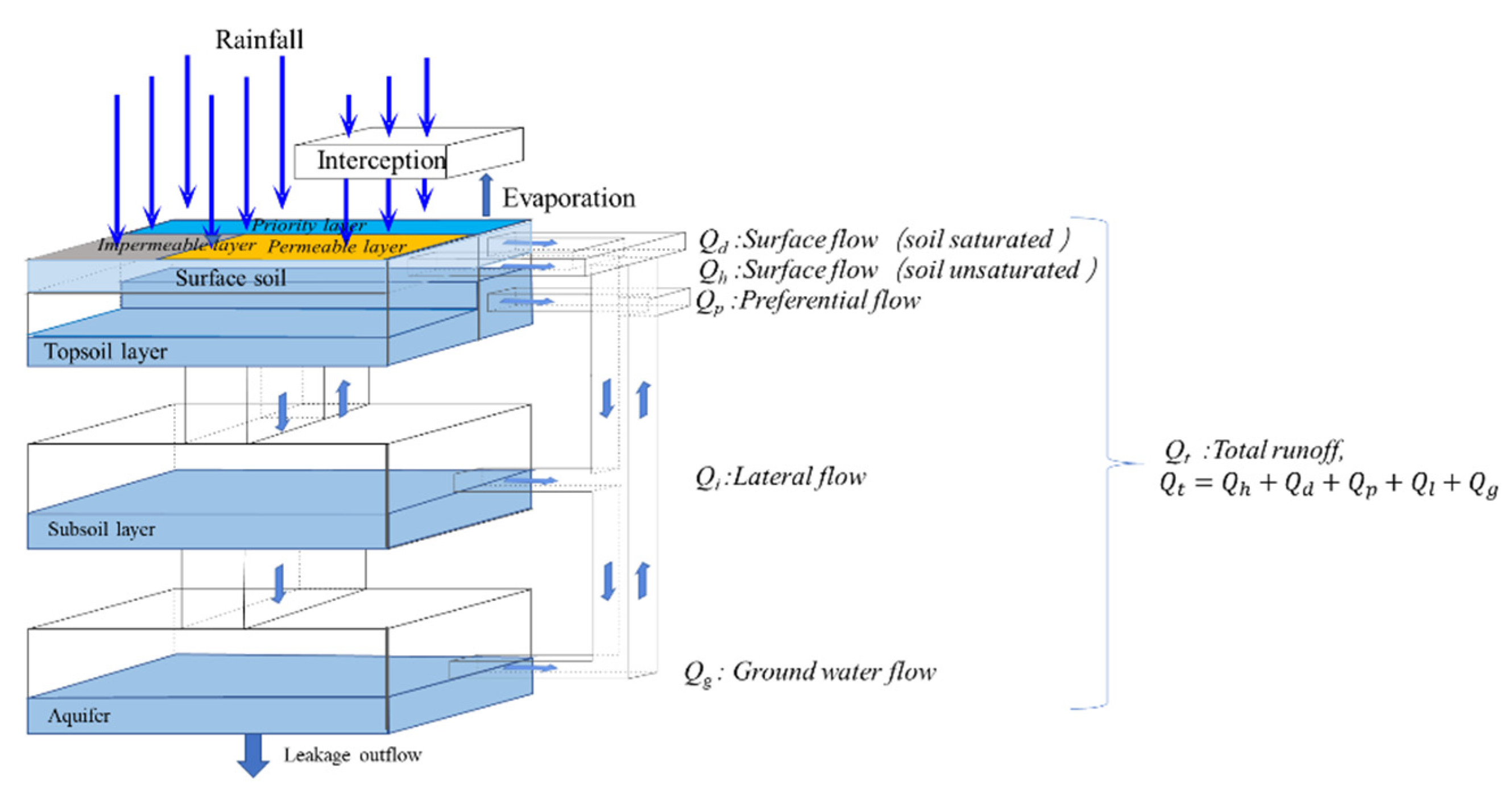
The SVSMR model is built based on the modular modeling structure and uses different runoff-generating mechanisms for different hydro-geomorphological response units, depending on their geological/hydrological characteristics. By using Geographic Information System (GIS) and Remote Sensing (RS) technologies, the model first identifies landform features (e.g., terrain, land use, vegetation cover, and soil type) on a hillslope scale, then defines the runoff generation mechanism depending on the characteristics of each hydro-geomorphological response unit [21,32]. The SVSMR model first used the GARTO model to calculate the infiltration process when the rainfall intensity exceeds the soil infiltration capacity. Using the one-dimensional numerical method proposed by Lai and Talbot [33], the infiltration and redistribution processes in the vadose zone are simulated. The GARTO model consisted of two main parts, including the Green–Ampt infiltration with Redistribution (GAR) model and the Talbot–Ogden (T-O) infiltration and redistribution method in a discretized moisture content domain [34]. It shows a better way to represent the exchange flow between surface water and groundwater compared with other methods like the classical Richard’s equation and the Green–Ampt (GA) [35] method. Then, the flow in the underground area is theoretically divided into three parts, including topsoil flow, subsoil flow, and aquifer flow (Figure 5). Integrated with the surface flow directly generated by the rainfall–runoff process, the river convergence process is calculated based on the kinematic wave method. The main parameters of the SVSMR model are classified into 4 categories, including evaporation parameters, interception parameters, infiltration parameters, and soil water dynamic balance parameters [36,37].

2.2.2. Model Improvement

The existing SVSMR model has been operationally used for forecasting flash flooding in 20 provinces in China (such as Henan and Hainan provinces) [38]. However, when this model is applied to a watershed with a special underlying surface like goaf, the model result is obviously overestimated, and relevant improvements should be implemented on the runoff generation and concentration mechanism of the goaf area.
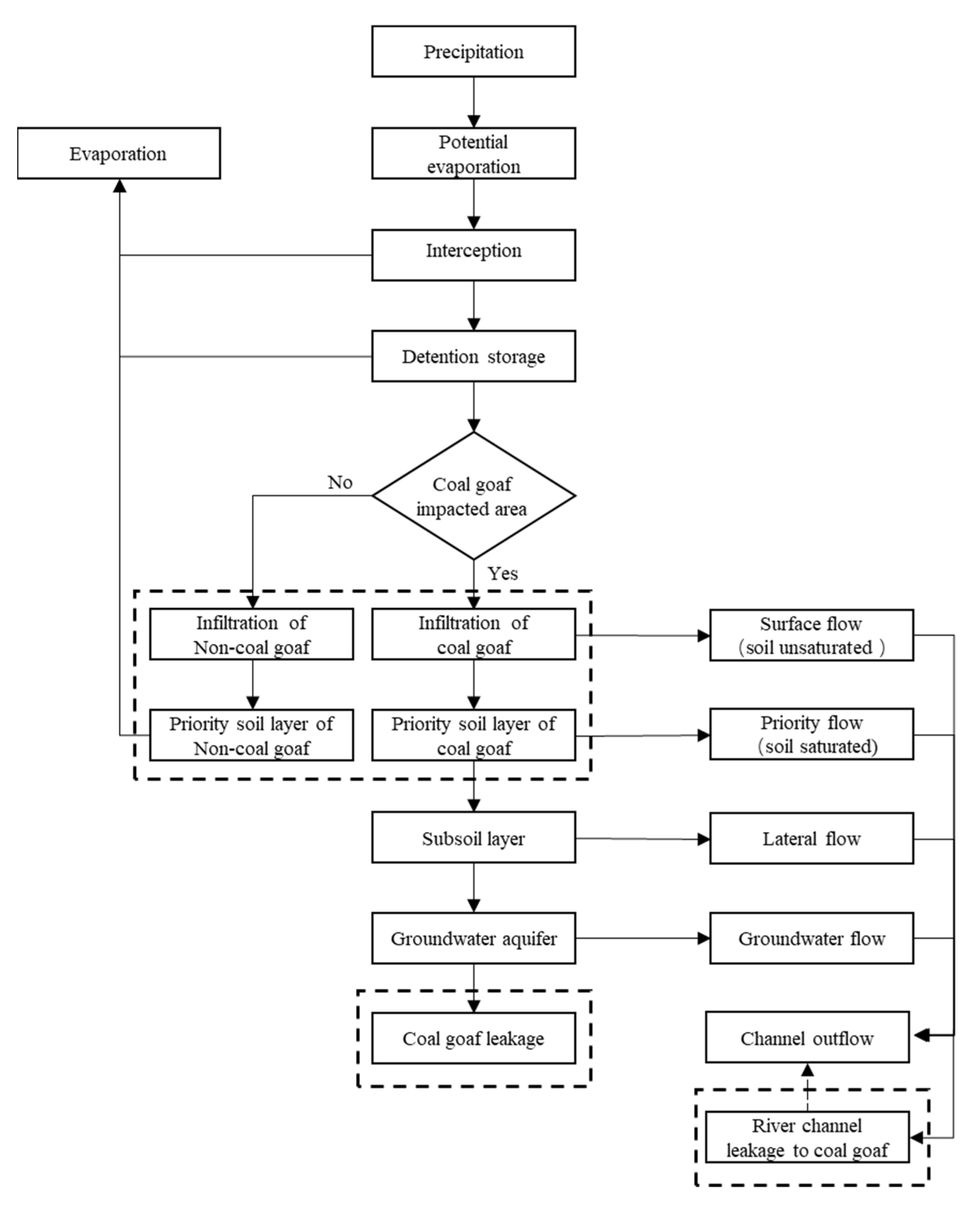
The improved parts of the SVSMR model are highlighted in Figure 6.
The improved model is based on the assumption that the goaf area within the simulated catchment will be unchanged during the whole modeling period. Then, depending on the location of the goaf area, the flow contributions to the river runoff are calculated separately:
  • When the goaf area is located under the land surface:
K m = β K s
Q m = K m W m
where Km is the equivalent permeability coefficient (mm/s) to the coal goaf impacted area, and β is the Empirical coefficient (-), which needs to be calibrated carefully. Ks is the soil saturated hydraulic conductivity (mm/s), Qm is the seepage discharge of goaf (mm), and Wm is the water content of the hollow fissure reservoir (mm). So, the total surface runoff can be calculated by the equation below:
Q t = Q h + Q d + Q p + Q l + Q g + Q m
where Qt is the total surface runoff; Qh and Qd are the surface runoff under unsaturated and saturated soil conditions, respectively; Qp is the preferential flow; Ql is the lateral flow; and Qg is the groundwater flow.
2.
When the goaf area is located under the riverbed:
We assumed that the loss of river flow caused by leakage to the coal goaf area below the riverbed is related to the quantity of river discharge.
S i = k Q i t
where Si is the amount of seepage (m3) in the river during time step i; k is the equivalent leakage coefficient [-]; Qi is the river discharge (m3/s) above the coal goaf area at time step I; and t is the calculation time interval (s).

2.3. Modeling Setup

With heterogeneous surface topography, land use, and soil distribution, the Yangquan Basin was divided into 53 hydrological response units. According to the runoff generation and confluence process of each hydrological response unit, the model is built based on each unit of similar generation and confluence process. Then the confluence process algorithm is used to link the sub-basin integration model to form an integration hydrological process model for the entire basin scale. A time–space source hydrological model, which is suitable for the preferential flow mechanism of the underlying surface of the coal goaf in the Yangquan Basin, was constructed. The model can allow for analysis of the runoff generation and confluence process of the coal goaf.

2.3.1. Validation of the Improved Model

The daily runoff at the Yangquan and Jiujie stations was selected for the model calibration (1990–2004) and validation (2005–2018). Based on the previous runoff simulation research [39,40,41] and our research, sensitive parameters were chosen in this study for calibration of the model. During the verification period, the paper used the original model and the improved model to verify the effect, and the effect of the model was evaluated using Nash-Sutcliffe Efficiency (NS) and Coefficient of Correlation (r2).
The Nash-Sutcliffe Efficiency (NS) was used to compare and assess the observed and simulated datasets. The equations were given as follows [42]:
N S = 1 t = 1 m ( Q o b s Q s i m ) 2 t = 1 m ( Q o b s Q o ) 2
where Q o b s , Q s i m ,   a n d   Q o are the observed data, simulated data, and average observed data, respectively, and m is the total number of data records. NS indicates more accurate simulation as it approaches 1. When NS is negative, the model is a worse predictor than the measured mean [43].
r 2 = t = 1 m Q o b s , t Q ¯ o b s Q s i m , i Q ¯ s i m 2 / t = 1 m Q o b s , t Q ¯ o b s 2 t = 1 m Q s i m , t Q ¯ s i m 2  
where   Q o b s   a n d   Q s i m are the measured and simulated data; similar to NS, as r2 approaches 1, the model more accurately simulates the measured data [43].

2.3.2. Scenario Analysis

The study of runoff response to the changes in meteorological conditions and coal mining activities is mainly to model the variation of catchment total runoff. These scenarios are set up according to the fluctuation in rainfall in the area, which is about 5–10%. This paper uses the following scenario analyses to quantitatively analyze the response of the runoff to the mining areas and rainfall in the Yangquan Basin:
  • Scenario 1: 2009–2018 mining area and reduce 5% rainfall in 2009–2018
  • Scenario 2: 2009–2018 mining area and reduce 10% rainfall in 2009–2018
  • Scenario 3: 2009–2018 mining area and increase 5% rainfall in 2009–2018
  • Scenario 4: 2009–2018 mining area and increase 10% rainfall in 2009–2018
  • Scenario 5: 2009–2018 rainfall and reduce 5% mining area in 2009–2018
  • Scenario 6: 2009–2018 rainfall and reduce 10% mining area in 2009–2018
  • Scenario 7: 2009–2018 rainfall and increase 5% mining area in 2009–2018
  • Scenario 8: 2009–2018 rainfall and increase 10% mining area in 2009–2018
The formula for change rate of runoff in year and month is:
η = (yi − y)/y × 100%
where η represents the average change rate of runoff (year, month); yi represents the average runoff (year, month) under the i scenario; and y represents the average real runoff (year, month) during the current year.

3. Results

3.1. Model Calibration and Validation

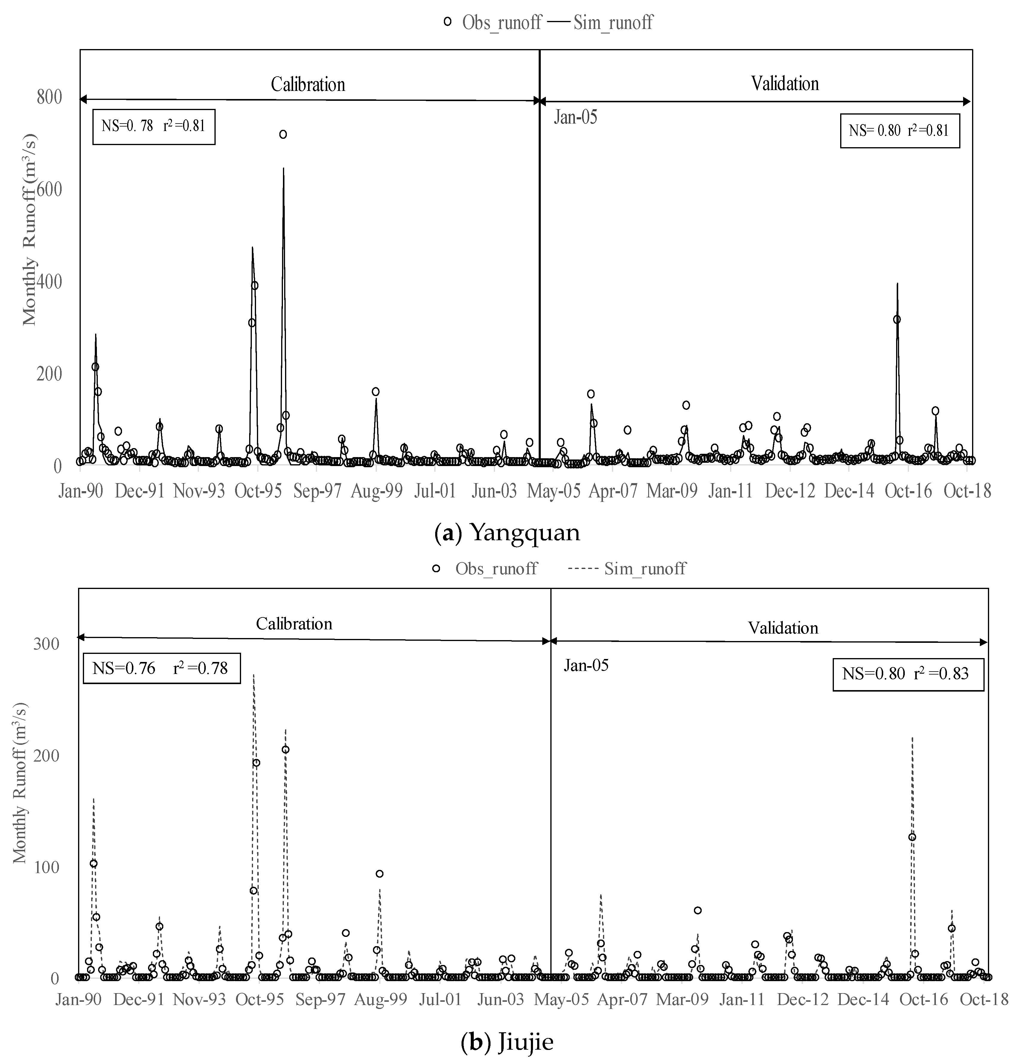
The NS value and r2 value are 0.78 and 0.81 in Yangquan and 0.76 and 0.78 in Jiujie, respectively, demonstrating good results between monthly simulated values and observed values in the calibration period. For the validation dataset, the NS value is 0.80, and the r2 value is 0.81 in Yangquan and 0.80 and 0.83 in Jiujie, respectively, showing that the validation results were comparable to the calibration dataset. Thus, the improved model can be used to simulate runoff in the basin, and the best-simulated parameters are shown in Table 2. The simulation results were extracted within the monthly time step to show in the figure (Figure 7).

3.2. Time–Space Response of Runoff under Scenarios

3.2.1. Annual Runoff Response Results

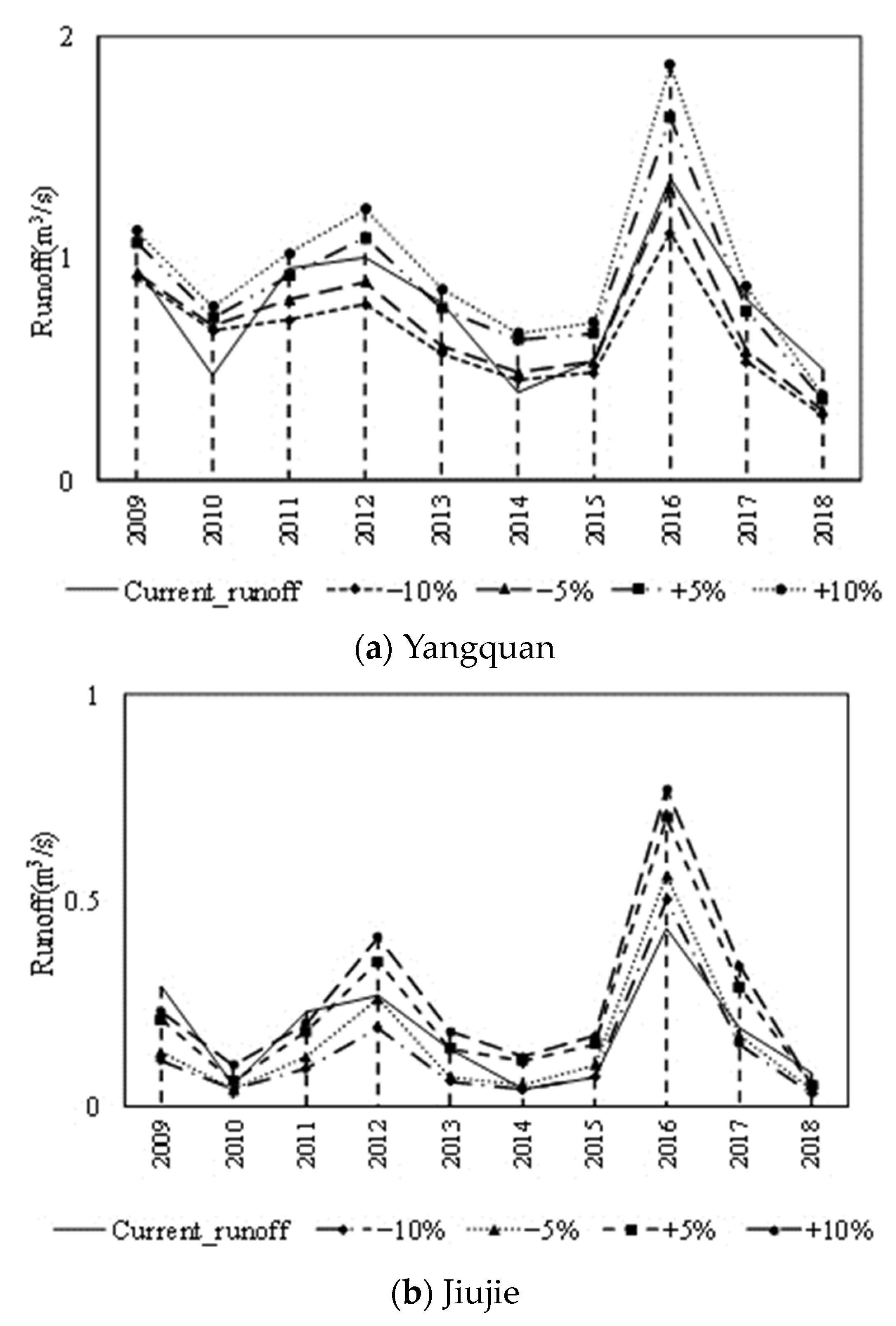
The runoff variation of meteorological and geological impacts is shown in Figure 8. The rainfall and runoff of each hydrological station are basically positively correlated in 2009–2018. The runoff of different hydrological stations has different levels of response to the increase or decrease in rainfall; in the case of reduced rainfall, the runoff response was relatively large in the Yangquan station in 2017, while the runoff response of the Jiujie station was obvious in 2013. Under the scenario of increased rainfall, the streamflow response of the Jiujie station was higher than that of the Yangquan station, and both the Yangquan and Jiujie stations showed greater runoff in 2014. 2014 is a year with a low level of runoff, and the runoff of the Jiujie station is smaller than that of the Yangquan station. This shows that the effect of rainfall is more obvious when the runoff is small. Rainfall was increased and decreased by the same proportion, but the respective changes in runoff response were disproportionate, indicating that in addition to rainfall, there are other factors that affect the runoff.
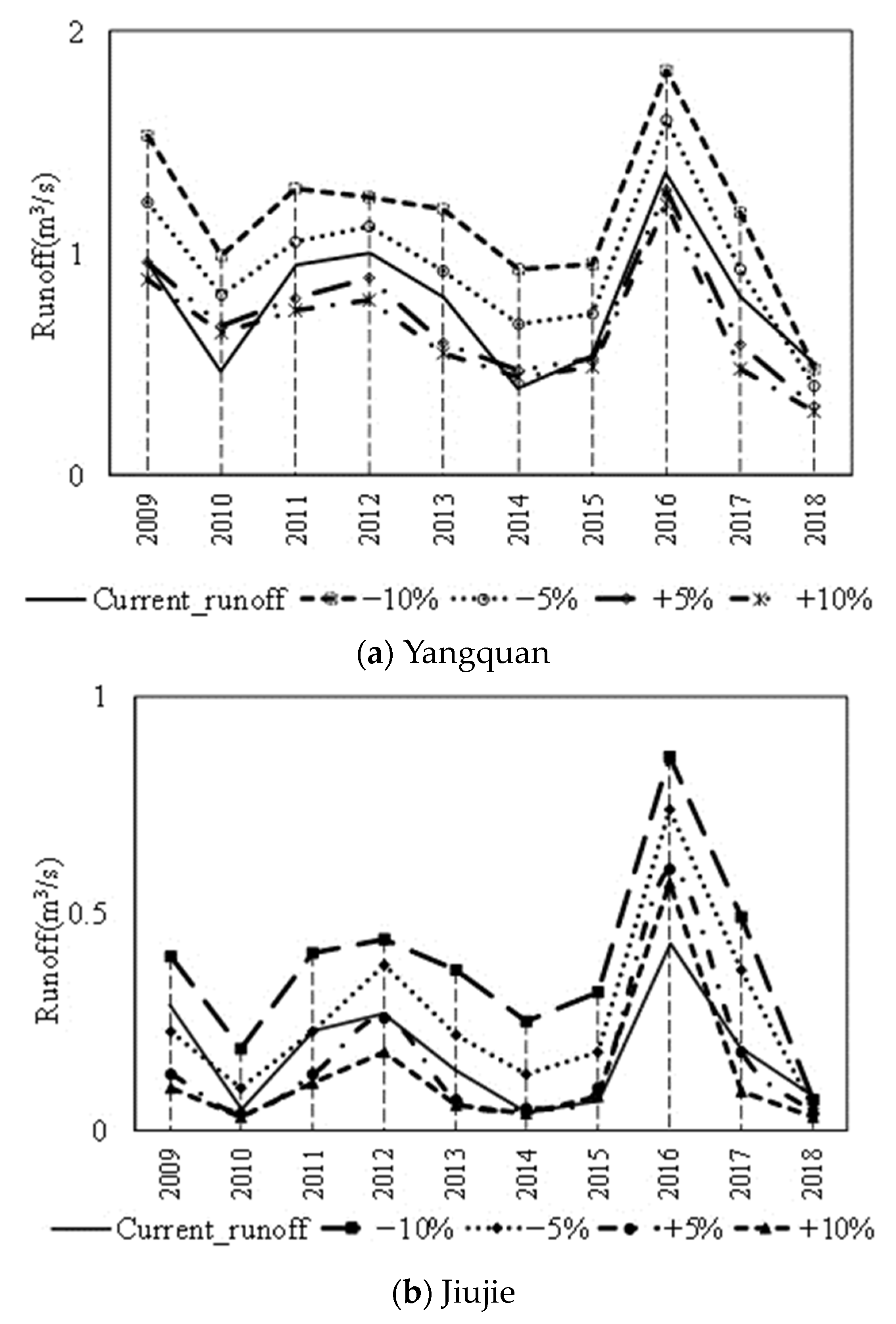
The results in Figure 9 show that the scenarios for change in mining area are negatively correlated with runoff, especially when the mining area is reduced by 10%, and the runoff shows an increasing trend. The degrees of response of runoff to the change in mining area are different for the Yangquan and Jiujie stations. The response of runoff to the reduction in the goaf area is greater than the response to the increase in the goaf area. In the case of a 5% and 10% reduction in the area of the goaf, the increase in the runoff of the Yangquan and Jiujie stations was the most obvious in 2014. In the case of a 5% and 10% increase in the area of the goaf, the runoff reduction of the Yangquan station was more pronounced in 2017, while the Jiujie station had a significant reduction in runoff in 2013. In most of the annual runoff responses under the mining area change scenarios, the Jiujie station showed more runoff than the Yangquan station. The area of the coal goaf in the Jiujie station is not extensive, implying that the Jiujie station is sensitive to the change in the goaf, and the impact of mining area change is more obvious in the runoff.

3.2.2. Seasonal Runoff Response Results

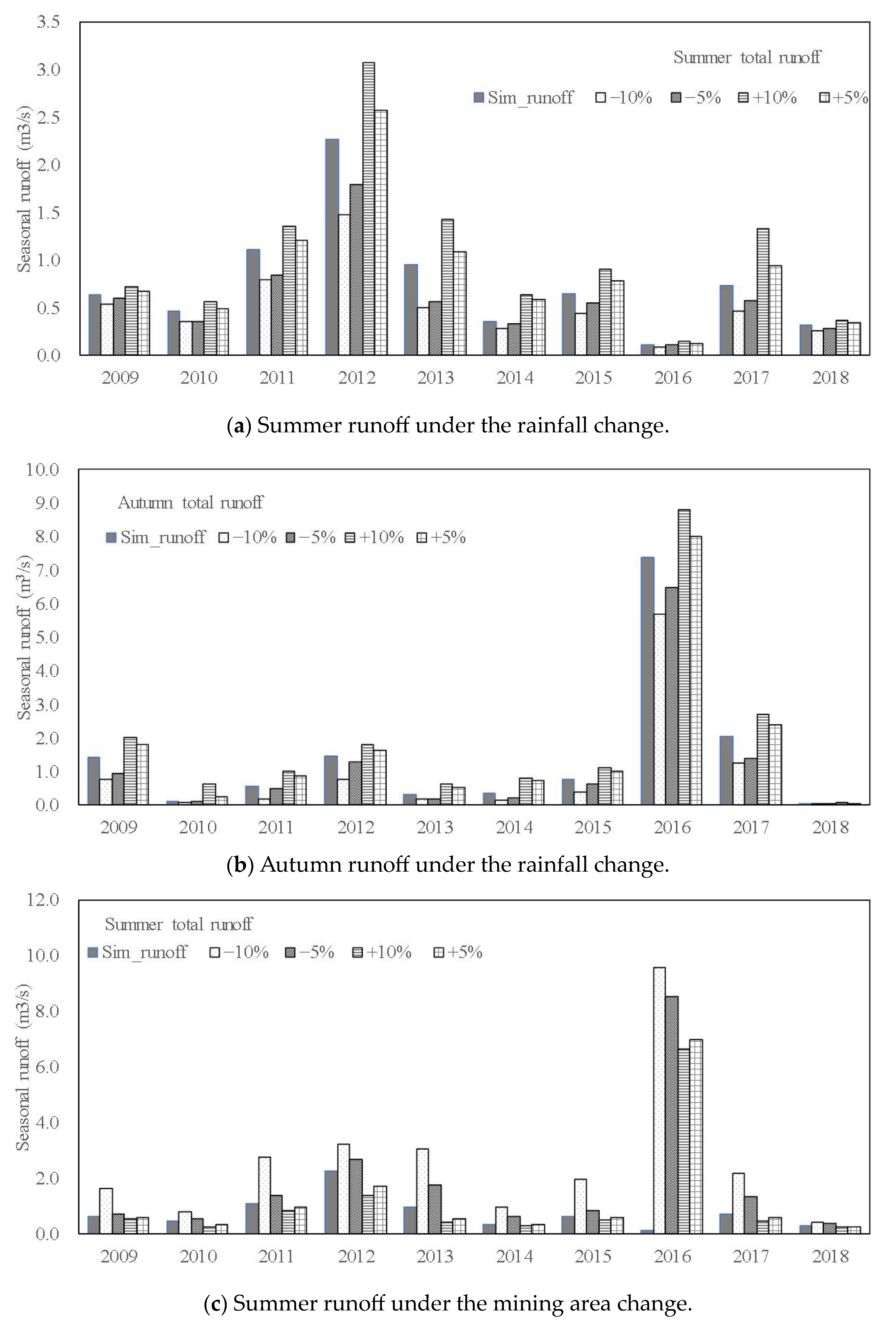
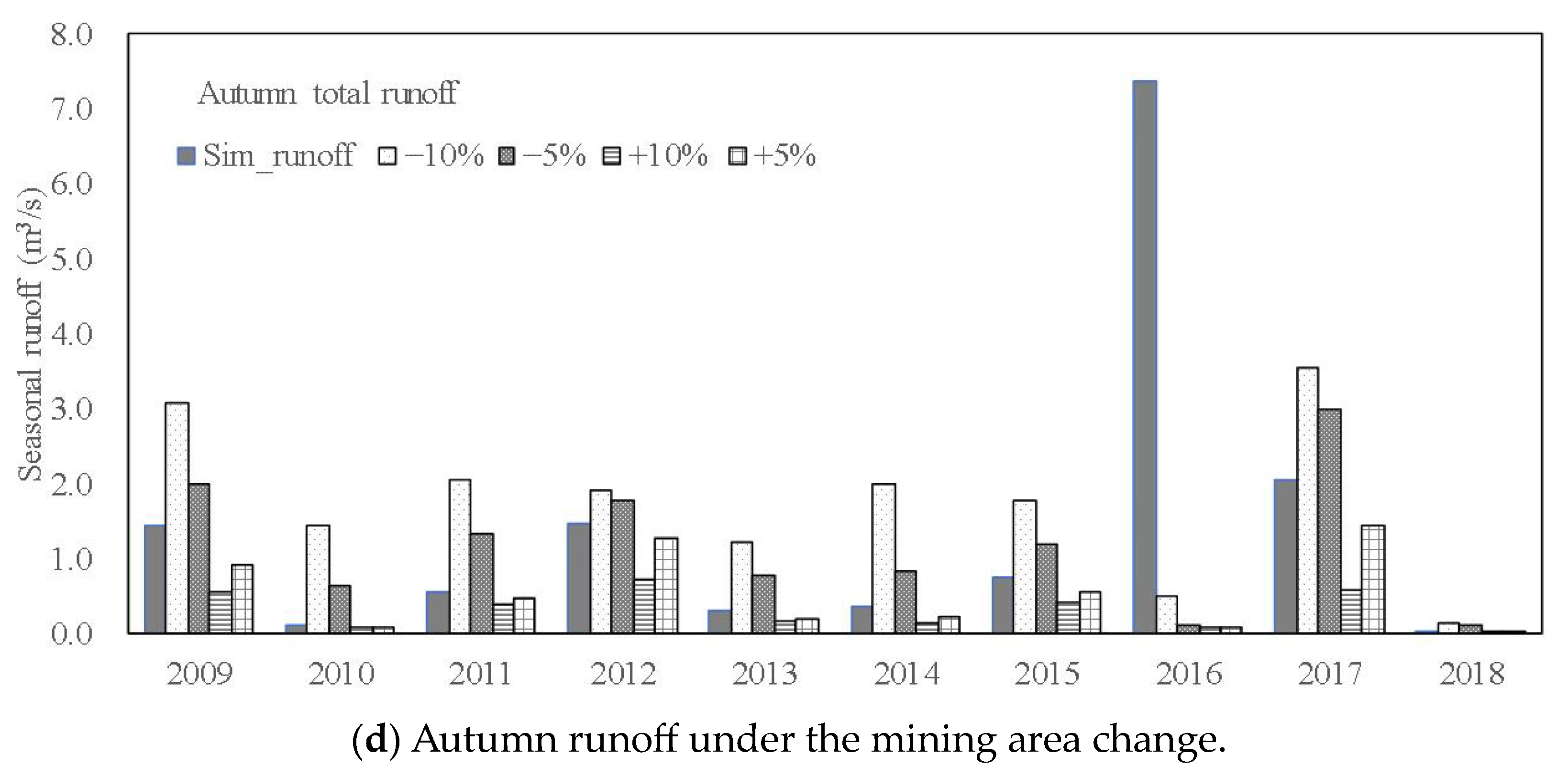
In order to better analyze the annual runoff response to rainfall and the mining area of the Yangquan Basin, the seasonal average runoff change rate of the Yangquan and Jiujie stations was calculated, which was based on the monthly average runoff under different scenarios. Among these, spring is from March to May, summer is from June to August, autumn is from September to November, and winter is from December to February. The effects of rainfall and mining area changes on seasonal runoff in the Yangquan and Jiujie stations are analyzed based on scenario simulation results (shown in Figure 10 and Table 2).
The results show that for the impact of rainfall and mining area changes on runoff, the response trends in the Yangquan and Jiujie stations are consistent. In most years, the runoff increases with increased rainfall and reduced mining area. The effects of rainfall and mining area changes on runoff are mainly concentrated in summer and autumn, and the runoff response in summer and autumn is greater than that in spring and winter. Between 2009 and 2018, with a 10% reduction in rainfall and a 10% increase in mining area, the degrees of runoff reduction in spring and winter increased year by year. In spring and winter, when rainfall and mining areas changed at the same percentage, the impact of the mining area changes on runoff was greater than the impact of rainfall changes on runoff.
In order to better study the influence of rainfall and mining area on runoff, this paper uses the Yangquan hydrological station as an example to calculate the runoff variation rate of each season under different scenarios (shown in Table 3).
Taking the Yangquan station as an example in the case of the rainfall change, in the spring, when the rainfall increases and decreases by the same proportion, the runoff change responds accordingly, such as in 2009, 2010, 2014, 2015, 2017. When the rainfall increases by 5% and decreases by 5%, the range of runoff changes is consistent; in summer, in most years, the effect of reduced rainfall on runoff has a greater impact on runoff than the increase in rainfall; in autumn, as the proportion of rainfall increases, the runoff response also shows significant changes; in winter, with the change in the proportion of rainfall increase and decrease, the trend of runoff response is not obvious, which shows the impact of rainfall changes on runoff is reduced.
For the mining area change scenarios, in the spring and winter, the impact of the change in the mining area on the runoff is gradually increasing, and the impact of reducing the mining area is greater than that of increasing the mining area. For example, in spring 2018, when the mining area was reduced by 5%, the change in runoff was about three times that for the situation of a 5% increase in the mining area. The change in runoff after the mining area was reduced by 10% is about four times that of the change in runoff after the mining area was increased by 10%; in summer and autumn, the change in runoff is fluctuant. The influence of the reduction in the mining area is much greater than the increase in the mining area on the runoff. When the mining area is reduced by 5% and 10%, the change rate for the runoff is quite different. When the mining area increases, the difference in the change rate for the runoff is small. This shows that under certain conditions when the impact of the mining area on runoff has been maximized, the runoff will not obviously change as the area of the mining area increases.

4. Discussion

Through the above analysis, the paper finds that the change in runoff in the Yangquan Basin is most affected by human activities—mainly coal mining activities. In order to quantitatively analyze the impact of rainfall and the mining area on runoff in the Yangquan Basin, this paper divides the study time into “natural period”, “exploitation period”, and “recovery period” [44]. The average runoff in the natural period can be obtained from the observation data, which is the benchmark runoff; second, based on the original hydrological model before the improvement, we can calculate the runoff during the mining and recovery periods without considering the impact of the mining area, and the difference from the benchmark runoff is the impact of rainfall change on runoff; finally, the difference between actual observation of runoff and calculation of runoff, considering the impact of the mining area, is the impact of human activities on runoff [45,46]. The results of the calculation of the runoff changes due to rainfall and human activities in the Yangquan Basin are shown in Table 4.
It can be concluded that mining activity is the main driving factor for the significant decline of runoff in the Yangquan Basin. The impact of coal mining on runoff in the Yangquan Basin is greater than the impact of rainfall on runoff during the mining period (1991–2004) [47,48]. The impacts on the runoff during the mining and recovery periods are both negative, and their contribution rates are 85.96% and 39.34%, respectively. The impact of rainfall on runoff during the recovery period is greater than that in the mining period, and the impact contribution rates are 60.66% and 14.04%, respectively. The impact contribution rates of rainfall on runoff reduction have been increasing over the years, and the contribution rate of mining activities on runoff has decreased. This indicates that the impact of human activities is gradually decreasing during the recovery period, and human activities had the most serious impact on the underlying surface during the mining period because the large-scale mining of coal mines caused serious changes in the underlying surface. Since 2005, the introduction of relevant coal mining remediation measures by the Chinese government has played a significant role in reducing coal mining activities, which protects water resources in the Yangquan Basin.

5. Conclusions

This study illustrates a systematic procedure for the calibration and validation of a hydrological model for the Yangquan Basin. Based on the formation mechanism of the goaf, a hydrological model considering the influence of the special underlying surface of the goaf is established.
(1) The annual runoff of the two hydrological stations in the Yangquan Basin is verified by the model, and the evaluation indicators meet the requirements, indicating that the improved model has good applicability in the Yangquan Basin and can be used to study the hydrological response under the influence of the mining area.
(2) Taking 2008–2018 as the base period, the effects of rainfall and mining area change on runoff in the Yangquan Basin were studied under different scenarios. The rainfall and runoff of each hydrological station were basically positively correlated, while the change in mining area was negatively correlated with runoff. The effects of rainfall and mining area changes on runoff are mainly concentrated in summer and autumn, and the runoff response in summer and autumn is greater than that in spring and winter. In spring and winter, when rainfall and mining areas change by the same percentage, the impact of changes in the mining area on runoff is greater than the effect of rainfall changes on runoff.
(3) During the coal mining period, the impact of human activities on runoff was much greater than the impact of rainfall on runoff, and this is the main reason for the sudden change in the rainfall–runoff relationship in the Yangquan Basin in 1990. The pre-exploitation rainfall has the same trend as the runoff. The impact of rainfall on runoff rises before and after the mining period and decreases during the mining period. The contribution rates of the rainfall on runoff are 14.04% and 60.66% during the mining and recovery periods, respectively, and the contribution rate of mining activities on runoff is gradually decreasing. During the mining and recovery periods, the impact contribution rates of mining activities are 85.96% and 39.34%, respectively.
Through hydrological simulation, this study provides a better understanding of runoff changes in the Yangquan Basin. The results indicate that the hydrological response to mining activities in the Yangquan Basin is undergoing changes, which can draw attention from other mining regions worldwide. To mitigate water-related hazards and resource depletion caused by mining activities, the methods used in this study can be applied in the policy-making processes of other regions to achieve sustainable development.

Author Contributions

Conceptualization, C.L. and Q.M.; methodology, C.L. and Z.X.; software, L.W.; validation, Z.X. and J.L.; formal analysis, Z.X.; investigation, J.L.; resources, Z.X.; data curation, Z.X.; writing—original draft preparation, J.L.; writing—review and editing, Z.X. and S.H.; visualization, Z.X.; supervision, W.S.; project administration, C.L.; funding acquisition, C.L. All authors have read and agreed to the published version of the manuscript.

Funding

This research was funded by “Spatiotemporal Variable Source Mixed Runoff Generation Model and Mechanism” of Innovation Team Project (No. JZ0145B2017), National Key R&D Program of China (No. 2018YFC1508105), Research and Application of Key Technologies for Dynamic Early Warning of Flash Flood Disasters in Henan Province (HNSW-SHZH-2015-06).

Data Availability Statement

All authors made sure that all data and materials support published claims and comply with field standards.

Acknowledgments

This research was supported by “Spatiotemporal Variable Source Mixed Runoff Generation Model and Mechanism” of Innovation Team Project (No. JZ0145B2017), National Key R&D Program of China (No. 2018YFC1508105), Research and Application of Key Technologies for Dynamic Early Warning of Flash Flood Disasters in Henan Province (HNSW-SHZH-2015-06), and Study on the infiltration mechanism of the special underlying surface of the coal mined-out area in Shanxi Province and the application of the results of the production and convergence of the coal mined-out area (ZNGZ2015-008_2).

Conflicts of Interest

The authors declare no conflict of interest.

References

  1. Wang, F. Study on the influence of coal mining on water resources in Shanxi. Henan Water Conserv. S. N. Water Transf. 2015, 19, 50–51. [Google Scholar]
  2. Hu, W.; Zhao, C. Evolution of Water Hazard Control Technology in China’s Coal Mines. Mine Water Environ. 2021, 40, 334–344. [Google Scholar] [CrossRef]
  3. Zhao, T. Study on the relationship between coal resources exploitation and water resources in Shanxi Province. Product. Res. 2016, 1, 40–44. [Google Scholar]
  4. Wei, Q.; Li, W.; Li, T.; Chang, J.; Wang, Q. Effects of Coal Mining on Shallow Water Resources in Semiarid Regions: A Case Study in the Shennan Mining Area, Shaanxi, China. Mine Water Environ. 2017, 36, 104–113. [Google Scholar]
  5. Knighton, J.; Walter, M. Critical rainfall statistics for predicting watershed flood responses: Rethinking the design storm concept. Hydrol. Process. 2016, 30, 3788–3803. [Google Scholar] [CrossRef]
  6. Zhang, L.; Karthikeyan, R.; Bai, Z.; Srinivasan, R. Analysis of streamflow responses to climate variability and land use change in the Loess Plateau region of China. Catena 2017, 154, 1–11. [Google Scholar] [CrossRef]
  7. Anand, J.; Gosain, A.K.; Khosa, R.; Srinivasan, R. Regional scale hydrologic modeling for prediction of water balance, analysis of trends in streamflow and variations in streamflow: The case study of the Ganga River basin. J. Hydrol. Reg. Stud. 2018, 16, 32–53. [Google Scholar] [CrossRef]
  8. Phung, Q.A.; Thompson, A.L.; Baffaut, C.; Costello, C.; Sadler, E.J.; Svoma, B.M.; Lupo, A.; Gautam, S. Climate and Land Use Effects on Hydrologic Processes in a Primarily Rain-Fed, Agricultural Watershed. J. Am. Water Resour. Assoc. 2019, 55, 1196–1215. [Google Scholar] [CrossRef]
  9. Jiang, X.; Gu, X.; He, H. The Influence of Coal Mining on Water Resources in the Kuye River Basin. J. Nat. Resour. 2010, 2, 126–133. [Google Scholar]
  10. Wu, X.; Dong, Y. Recognition of runoff changes in mining area based on SWAT model. Environ. Sci. Technol. 2018, 41, 175–180. [Google Scholar]
  11. Li, T.; Zhang, Y. Study on simulation of special underlying surface runoff in goaf area. Water Resour. Hydropower Eng. 2022, 53, 31–42. [Google Scholar]
  12. Leavesley, G.; Lichty, R.; Troutman, B. Precipitation-Runoff Modeling System: User’s Manual. J. Landolt-Börnstein—Group II Mol. Radic. 1991, 4, 206–207. [Google Scholar]
  13. Li, J.; Qiao, Y.; Lei, X.; Kang, A.; Wang, M.; Liao, W.; Wang, H.; Ma, Y. A two-stage water allocation strategy for developing regional economic-environment sustainability. J. Environ. Manag. 2019, 244, 189–198. [Google Scholar] [CrossRef] [PubMed]
  14. Xu, Z.; Cheng, L. Progress on studies and applications of the Distributed Hydrological Models. J. Hydraul. Eng. 2010, 41, 1009–1017. [Google Scholar]
  15. Zhao, R. The Xinanjiang Model Applied in China. J. Hydrol. 1992, 135, 371–381. [Google Scholar]
  16. Lin, K.; Lv, F.; Chen, L.; Singh, V.P.; Zhang, Q.; Chen, X. Xinanjiang model combined with Curve Number to simulate the effect of land use change on environmental flow. J. Hydrol. 2004, 519, 3142–3152. [Google Scholar] [CrossRef]
  17. Ma, H.; Yang, D.; Tan, S.K.; Gao, B.; Hu, Q. Impact of climate variability and human activity on streamflow decrease in the Miyun Reservoir catchment. J. Hydrol. 2010, 389, 317–324. [Google Scholar] [CrossRef]
  18. Yang, D.; Herath, S.; Musiake, K. Hillslope-based hydrological model using catchment area and width functions. Hydrol. Sci. J. 2002, 47, 49–65. [Google Scholar] [CrossRef]
  19. Liu, C.J.; Wen, L.; Zhou, J.; Zhao, X.T.; Guo, L.; Wei, Y.Q. Comparative analysis of hydrological and hydrodynamic calculation method for flash flood in small watershed. J. China Inst. Water Resour. Hydropower Res. 2019, 17, 262–270. [Google Scholar]
  20. Wen, L.; Liu, C. Development of hydrological model considering the coal mined-out area special underlying surface and its application in small basins of Shanxi Province. J. Glaciol. Geocryol. 2017, 39, 375–383. [Google Scholar]
  21. Guo, L.; Ding, L.; Sun, D.; Liu, C.; He, B.; Liu, R. Key techniques of flash flood disaster prevention in China. J. Hydraul. Eng. 2018, 49, 101–114. [Google Scholar]
  22. Niu, X.; Li, Z.; Yang, Z. Effects of Coal Mining on Water Resources in Shanxi Province; Shanxi Coalfield Hydrogeology Team, 2003. [Google Scholar]
  23. Guo, Q.; Han, Y.; Yang, Y.; Fu, G.; Li, J. Quantifying the Impacts of Climate Change, Coal Mining and Soil and Water Conservation on Streamflow in a Coal Mining Concentrated Watershed on the Loess Plateau, China. Water 2019, 11, 1054. [Google Scholar] [CrossRef]
  24. Li, P.; Qian, H.; Howard, K.; Wu, J. Building a new and sustainable “Silk Road economic belt”. Environ. Earth Sci. 2015, 74, 7267–7270. [Google Scholar] [CrossRef]
  25. Li, P.; Wu, J.; Qian, H.; Lyu, X.; Liu, H. Origin and assessment of groundwater pollution and associated health risk: A case study in an industrial park, northwest China. Environ. Geochem. Health 2014, 36, 693–712. [Google Scholar] [CrossRef] [PubMed]
  26. Rong, X.; Pang, J.; Han, J. Distribution trends of drought and flood disasters and climate background from 1958 to 2012 in Shanxi province. J. Arid. Land Resour. Environ. 2018, 32, 97–102. [Google Scholar]
  27. Gu, P. Impact Studies on the Mechanism and Quantitative Model of Coal Mining on River Runoff in Gujiao City of Shanxi Province. Master’s Thesis, Zhengzhou University, Zhengzhou, China, 2015. [Google Scholar]
  28. Li, P.; Li, X.; Meng, X.; Li, M.; Zhang, Y. Appraising groundwater quality and health risks from contamination in a semiarid region of northwest China. Expo. Health 2016, 8, 361–379. [Google Scholar] [CrossRef]
  29. Li, P.; Qian, H.; Wu, J.; Zhang, Y.; Zhang, H. Major ion chemistry of shallow groundwater in the Dongsheng coalfield, Ordos basin, China. Mine Water Environ. 2013, 32, 195–206. [Google Scholar] [CrossRef]
  30. Li, P.; Tian, R.; Xue, C.; Wu, J. Progress, opportunities, and key fields for groundwater quality research under the impacts of human activities in China with a special focus on western China. Environ. Sci. Pollut. Res. 2017, 24, 13224–13234. [Google Scholar] [CrossRef]
  31. Chang, J. On Influence of Coal Mining in Coal-mining Areas in Shanxi Province on Water Resource. Product. Res. 2015, 2, 63–67+161. [Google Scholar]
  32. Liu, S.; Li, W.; Wang, Q. Zoning method for environmental engineering geological patterns in underground coal mining areas. Sci. Total Environ. 2018, 634, 1064–1076. [Google Scholar] [CrossRef]
  33. Lai, W.; Ogden, F.L.; Steinke, R.C.; Talbot, C.A. An efficient and guaranteed stable numerical method for continuous modeling of infiltration and redistribution with a shallow dynamic water table. Water Resour. Res. 2015, 51, 1514–1528. [Google Scholar] [CrossRef]
  34. Talbot, C.; Ogden, F. A method for computing infiltration and redistribution in a discretized moisture content domain. Water Resour. Res. 2008, 44, 8. [Google Scholar] [CrossRef]
  35. Green, W.; Ampt, G. Studies on soil physics 1: The flow of air and water through soils. J. Agric. Sci. 1911, 4, 1–24. [Google Scholar]
  36. Andreas, K.; Nikola, R. Sustainable development of energy, water and environment systems. Water Resour. Manag. 2011, 10, 33–39. [Google Scholar]
  37. Sridhar, V.; Kang, H.; Ali, S.A. Human-Induced Alterations to Land Use and Climate and Their Responses for Hydrology and Water Management in the Mekong River Basin. Water 2019, 11, 1307. [Google Scholar] [CrossRef]
  38. Research and Application on Key Technologies of Dynamic Flood Warning in Henan Province; China Institute of Water Resources and Hydropower Research: Beijing, China, 2015.
  39. Abbaspour, K.C.; Yang, J.; Maximov, I.; Siber, R.; Bogner, K.; Mieleitner, J.; Zobrist, J.; Srinivasan, R. Modelling hydrology and water quality in the pre-alpine/alpine Thur watershed using SWAT. J. Hydrol. 2007, 333, 413–430. [Google Scholar] [CrossRef]
  40. Bieger, K.; Hörmann, G.; Fohrer, N. Detailed spatial analysis of SWAT-simulated surface runoff and sediment yield in a mountainous watershed in China. Hydrol. Sci. J. 2014, 60, 784–800. [Google Scholar] [CrossRef]
  41. Ghaffari, R.; Aranyosi, A.J.; Richardson, G.P.; Freeman, D.M. Tectorial membrane travelling waves underlie abnormal hearing in Tectb mutant mice. Nat. Commun. 2010, 1, 96. [Google Scholar] [CrossRef]
  42. Nash, J.; Sutcliffe, J. River flow forecasting through conceptual models part I—A discussion of principles. J. Hydrol. 1970, 10, 282–290. [Google Scholar] [CrossRef]
  43. Moriasi, D.N.; Arnold, J.G.; Van Liew, M.W.; Bingner, R.L.; Harmel, R.D.; Veith, T.L. Model evaluation guidelines for systematic quantification of accuracy in watershed simulations. Am. Soc. Agric. Biol. Eng. 2007, 50, 885–900. [Google Scholar] [CrossRef]
  44. Xin, Z.; Li, Y.; Zhang, L.; Ding, W.; Ye, L.; Wu, J.; Zhang, C. Quantifying the relative contribution of climate and human impacts on seasonal streamflow. J. Hydrol. 2019, 574, 936–945. [Google Scholar] [CrossRef]
  45. Kendorski, F. Effect of High-Extraction Coal Mining on Surface and Ground Waters. In Proceedings of the 12th Conference on Ground Control in Mining, Morgantown, WV, USA, 3–5 August 1993. [Google Scholar]
  46. Chiew, F.; Fu, G.; Post, D.; Zhang, Y.; Wang, B.; Viney, N. Impact of coal resource development on streamflow characteristics: Influence of climate variability and climate change. Water 2018, 10, 1161. [Google Scholar] [CrossRef]
  47. Sun, S.; Chen, H.; Ju, W.; Song, J.; Zhang, H.; Sun, J.; Fang, Y. Effects of climate change on annual streamflow using climate elasticity in Poyang Lake Basin, China. Theor. Appl. Climatol. 2013, 112, 169–183. [Google Scholar] [CrossRef]
  48. Wu, J.; Sun, Z. Evaluation of shallow groundwater contamination and associated human health risk in an alluvial plain impacted by agricultural and industrial activities, mid-west China. Expo. Health 2016, 8, 311–329. [Google Scholar] [CrossRef]
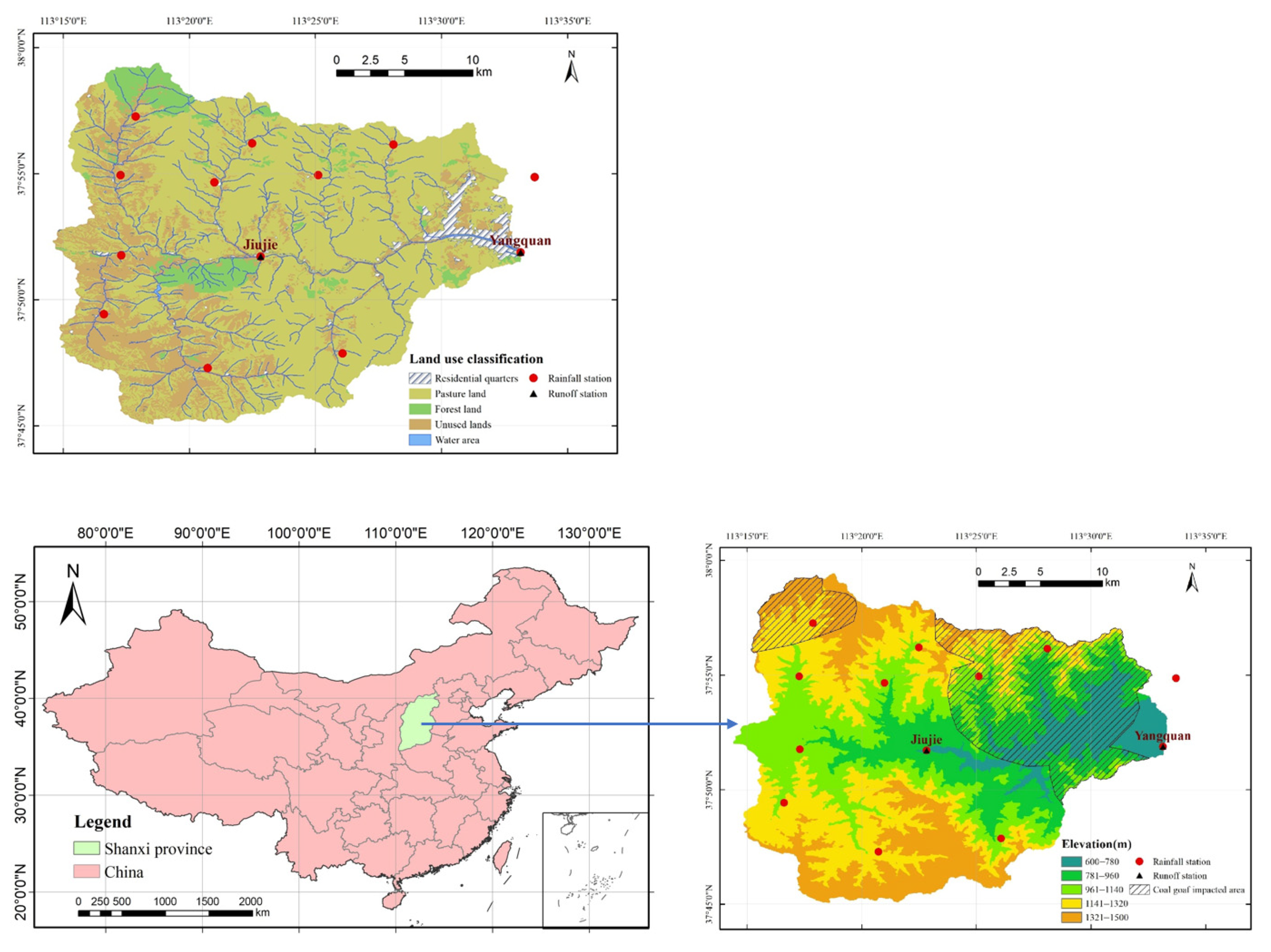
Figure 1. Goaf distribution and land use classification of Yangquan Basin.
Water 15 03058 g001
Figure 2. Soil water characteristic curve. (a) Relationship between water content and suction, and (b) relationship between relative permeability coefficient and matrix suction.
Water 15 03058 g002
Figure 3. Annual rainfall and annual runoff in Yangquan Basin.
Water 15 03058 g003
Figure 4. Schematic diagram of the runoff movement.
Water 15 03058 g004
Figure 5. Runoff generation model structure.
Water 15 03058 g005
Figure 6. Calculation flow chart of the improved SVSMR model.
Water 15 03058 g006
Figure 7. Observed and simulated monthly runoff of calibration and validation in Yangquan and Jiujie stations.
Water 15 03058 g007
Figure 8. Annual runoff response under rainfall change scenarios.
Water 15 03058 g008
Figure 9. Annual runoff response under the mining area change scenarios.
Water 15 03058 g009
Figure 10. Seasonal runoff responses under different scenarios in Jiujie station.
Water 15 03058 g010aWater 15 03058 g010b
Table 1. The characteristics of different periods in Yangquan Basin.
PeriodYearCharacteristicInfluence
Before mining1977–1990No mining activitiesLittle influence
Mining1991–2004Unreasonable activitiesInfluence on the underlying surface
After mining2005–2018Sustainable mining activitiesReduced influence on the underlying surface
Table 2. List of sensitive parameters in the model.
NamesDescriptionsCalibration Results
K c Daily evaporation coefficient [-]0.85
I C S Interception capacity of major vegetation types in summer [mm]6.32
p e r f d Percentage of watershed [%]0.13
W f d Mean water storage in depression [mm]4.92
K m Soil hydraulic conductivity (mm/s) of the coal goaf [m/s]1.14 × 10 −5
K s Saturated hydraulic conductivity [m/s]1.14 × 10 −6
θ c Porosity [-]0.43
θ r Residual water content [-]0.078
α VG model parameter [-]0.036
n VG model parameter [-]1.56
θ 0 Initial water content of soil [-]0.12
θ f c Field water holding rate [-]0.40
k s 2 g Soil leakage coefficient to groundwater [m/d]0.15
p e r i p Percentage of impervious area [-]0.10
p e r p Priority flow area percentage [-]0.16
k p 1 Priority outflow linear coefficient [-]0.079
k p 2 Priority outflow nonlinear coefficient [-]0.14
k i 1 Linear coefficient of effluent flow in soil [-]0.62
k i 2 Nonlinear coefficient of effluent flow in soil [-]0.72
k g s Groundwater reservoir leakage coefficient [-]0.0027
k g Lateral outflow coefficient [-]0.0041
kequivalent leakage coefficient [-]0.4023
α o f p Kinematic parameter alpha for overland flow routing [-]1.10
n o f p Kinematic parameter m for overland flow routing [-]1.75
α c h a n Kinematic parameter alpha for channel flow routing [-]1.20
n c h a n Kinematic parameter m for channel flow routing [-]1.56
Table 3. The seasonal runoff variation rate under different scenarios in Yangquan station.
SeasonYearΔ RainfallΔ Mining Area
−10%−5%+5%+10%−10%−5%+5%+10%
2009−0.79%−0.40%0.40%0.79%6.86%3.86%−3.91%−6.92%
2010−1.00%−0.50%0.50%1.51%10.54%5.02%−4.01%−7.03%
2011−1.78%−1.17%0.57%1.18%11.81%5.90%−3.55%−6.50%
2012−3.88%−1.94%1.28%2.55%14.14%7.10%−5.15%−8.37%
Spring2013−4.96%−2.81%2.15%3.55%15.61%7.85%−4.30%−7.11%
2014−4.02%−2.42%2.42%4.02%19.32%8.86%−4.02%−8.03%
2015−6.69%−3.34%3.34%7.57%24.72%12.74%−4.22%−8.52%
2016−6.80%−3.84%2.96%5.92%27.36%12.72%−5.76%−9.76%
2017−6.53%−3.27%3.27%7.61%31.51%13.07%−4.31%−7.57%
2018−9.57%−4.90%5.68%9.57%32.41%15.04%−4.90%−8.80%
2009−17.87%−15.99%−12.71%−9.37%36.04%10.27%−7.34%−13.65%
2010−3.18%−1.94%1.75%3.69%26.10%7.01%−4.25%−7.19%
2011−19.28%−10.25%0.85%17.50%55.09%17.33%−10.40%−15.78%
2012−19.77%−11.05%14.99%34.70%31.96%15.19%−10.14%−17.22%
Summer2013−25.11%−18.44%11.76%31.22%88.49%37.31%−17.68%−25.63%
2014−12.56%−7.45%22.50%28.71%69.84%30.36%−7.06%−13.12%
2015−15.92%−8.29%14.59%23.97%70.20%22.64%−7.05%−12.67%
2016−15.92%−7.05%8.91%18.32%26.81%12.25%−8.32%−11.63%
2017−21.94%−11.95%14.41%43.30%114.80%47.73%−12.35%−19.55%
2018−12.50%−8.23%9.27%18.02%47.81%22.81%−8.23%−13.02%
2009−14.63%−11.25%8.38%13.48%56.00%13.97%−14.79%−22.47%
2010−8.67%−7.02%7.05%22.89%76.73%29.16%−9.57%−12.91%
2011−19.62%−6.12%8.81%15.11%45.84%24.39%−8.48%−18.04%
2012−14.22%−4.66%4.66%8.61%19.38%10.87%−6.80%−18.12%
2013−14.00%−11.41%16.78%23.33%75.25%38.48%−13.23%−17.25%
Autumn2014−18.72%−11.96%21.53%29.39%105.30%34.85%−14.69%−20.90%
2015−17.73%−8.52%9.62%16.22%49.20%21.83%−10.11%−17.30%
2016−8.70%−4.47%4.24%6.64%79.04%12.94%−6.30%−10.04%
2017−21.87%−15.43%13.51%32.12%67.52%40.45%−15.28%−30.19%
2018−13.08%−7.68%8.55%14.84%51.97%25.66%−9.94%−13.08%
20090.00%0.00%0.51%0.51%8.48%4.18%−3.68%−6.46%
2010−0.57%−0.57%1.02%1.02%10.06%5.28%−3.76%−6.37%
2011−2.45%−1.81%0.00%1.23%10.86%5.43%−4.21%−7.24%
2012−2.04%−1.39%2.04%2.77%13.65%6.86%−4.09%−6.80%
Winter2013−3.83%−1.54%1.57%3.05%15.34%7.64%−3.83%−7.61%
2014−3.52%−1.76%2.59%5.19%19.91%10.37%−3.52%−7.78%
2015−5.79%−3.82%1.97%4.86%25.12%10.65%−4.75%−7.64%
2016−6.39%−4.31%2.08%5.28%25.56%11.67%−6.39%−9.58%
2017−6.05%−4.77%2.47%6.09%30.26%13.34%−6.05%−8.39%
2018−10.86%−6.80%2.78%6.85%35.30%14.98%−6.80%−10.86%
Table 4. The impact of rainfall and human activities on runoff in Yangquan Basin.
YearAverage QobsAverage QsimRainfall ChangesMining Activities
ΔQΔ% ΔQΔ%
(m3/s)(m3/s)(m3/s)(%)(m3/s)(%)
1977–19901.261.27
1991–20040.71.19−0.08−14.04%−0.49−85.96%
2005–20180.660.9−0.37−60.66%−0.24−39.34%
Note: Qobs is the observed runoff, Qsim is the simulated runoff, ΔQ is the amount of runoff change, and Δ% is the contribution rate to the runoff from different changes.
Disclaimer/Publisher’s Note: The statements, opinions and data contained in all publications are solely those of the individual author(s) and contributor(s) and not of MDPI and/or the editor(s). MDPI and/or the editor(s) disclaim responsibility for any injury to people or property resulting from any ideas, methods, instructions or products referred to in the content.