Article

Groundwater Circulation Mechanism of the Upstream Area of Beiniuchuan River Using Isotope–Hydrochemical Tracer

1
Civil-Military Integration Center of Geological Survey, China Geological Survey, Chengdu 610036, China
2
Institute of Hydrogeology and Environmental Geology, Chinese Academy of Geological Science, Shijiazhuang 050061, China
*
Author to whom correspondence should be addressed.
Water 2023, 15(22), 4000; https://doi.org/10.3390/w15224000
Submission received: 8 October 2023 / Revised: 13 November 2023 / Accepted: 15 November 2023 / Published: 17 November 2023

Abstract

:
In order to achieve the rational development and utilization of underground water resources in the Dongsheng mining area under coal mining conditions, we selected the upstream area of Beiniuchuan River as a typical region. Through field investigations, sampling tests, and the application of hydrochemical and isotope techniques, we traced the groundwater circulation mechanism in the Dongsheng mining area. The results indicate that the majority of the Quaternary alluvial and Salawusu Formation groundwater is of the HCO3-Ca type, with a TDS content below 300 mg/L. However, in some areas, the hydrochemical type becomes complex due to anthropogenic contamination. The shallow-buried Yan’an Formation groundwater is either of the HCO3-Ca·Mg type or the HCO3·SO4-Ca·Mg type, with TDS content ranging from 200 to 750 mg/L. The Yan’an Formation at depths greater than 40 m exhibits complex water chemistry, with a TDS content higher than 500 mg/L, and it belongs to the Cl-Na type, with TDS around 700 mg/L. The hydrogen and oxygen isotope results indicate that the local groundwater is primarily recharged via atmospheric precipitation. The 3H and 14C results show that the Quaternary alluvial and shallow-buried Yan’an Formation groundwater has a fast turnover rate, while the deep-buried Yan’an Formation and Yan’chang Formation groundwater have a slower turnover rate. The regional groundwater circulation can be generalized into three flow systems: shallow, intermediate, and deep. Under the influence of coal mining activities, the water circulation conditions in the study area have undergone significant changes. The sealing integrity of the Yan’an Formation has been compromised, and precipitation and shallow groundwater have enhanced the vertical infiltration capacity of the formation, increasing the proportion of groundwater participating in the intermediate flow system. As a result, the river runoff mainly dependent on the discharge from the shallow flow system has drastically decreased.

1. Introduction

Dongsheng Coalfield is one of the 14 large-scale coal bases planned and constructed by the government. At the same time, the coalfield is one of the important areas in northern China that suffers from aridity and water scarcity. Coal mining activities have disturbed the aquifer structure, altered the groundwater circulation pattern, and exacerbated water shortages in this area [1,2,3,4]. Groundwater resources account for over 70% of local drinking water resources. Therefore, the effective protection of groundwater during the coal mining process is one of the key issues in Dongsheng Coalfield [5,6,7,8]. Beiniuchuan River is an important river in Dongsheng Coalfield, and the aquifer conditions and its relationship with coal seams in this area are representative [9]. However, there are few studies on the specific groundwater circulation mechanism in this typical region.
The groundwater circulation pattern is an essential basis for the development, utilization, management, and protection of groundwater resources [10,11,12,13]. Environmental tracers, such as water chemical composition and hydrogen–oxygen–carbon isotopes, serve as markers and time indicators for water circulation. They are widely used in groundwater circulation studies in arid regions [4,14,15,16]. Their applications mainly focus on identifying the sources of groundwater [17,18,19], recharge and discharge processes [20,21,22], and groundwater ages [23,24,25], as well as determining hydraulic connections [26,27,28,29] and the transformation relationship and quantity between surface water and groundwater [30,31,32,33]. Beiniuchuan River is a river located in the southern part of Dongsheng Coalfield. Since the 1960s, the annual runoff of the Beiniuchuan River has decreased from 126 million cubic meters to 25 million cubic meters (2000–2010 average) [34]. Therefore, this study takes the upper and middle reaches of the Beiniuchuan River, the main runoff area, as the research area. Based on the regional hydrogeological conditions, hydrogen–oxygen isotopes, carbon isotopes, and water chemical composition are used as tracers to investigate the groundwater circulation characteristics in the upper and middle reaches of the Beiniuchuan River. This study aims to provide a scientific basis for the management and protection of groundwater resources and water supply security in the coalfield area.

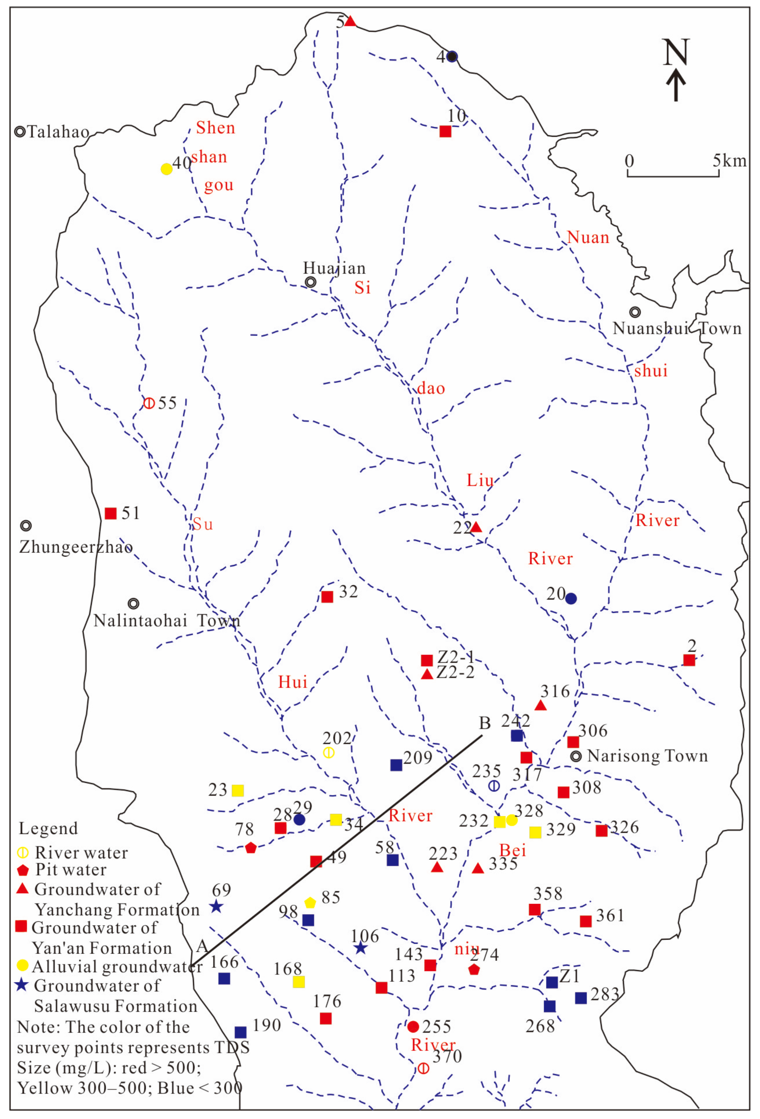
2. Overview of the Study Area

The upper and middle reaches of the Beiniuchuan River are located in the border area between Ordos City, Inner Mongolia Autonomous Region, and Yulin City, Shaanxi Province. The main tributaries are the Shuhui River and the Nuanshui River. The terrain in the region is mainly composed of low hills, with a relative elevation difference ranging from 50 to 200 m. The overall topography is higher in the north and lower in the south, with multiple levels of valleys and the development of aeolian sand dunes in the southern part. The climate in the study area is arid, with an average annual precipitation of 350.6 mm and an average annual evaporation of about 2300 mm [35].
Dongsheng Coalfield is a large Jurassic coal-bearing basin. The main coal-bearing stratum is the Middle–Lower Jurassic Yan’an Formation (J1–2y) [36], and its sedimentary basement is the Upper Triassic Yan’chang Formation (T3y). Overlying strata include the Neogene (N) and the Upper Pleistocene Salawusu Formation (Q3s), Quaternary alluvial deposits ( Q 4 al + pl ), and Quaternary aeolian sand deposits ( Q 4 eol ). The overlying strata exhibit discontinuity, with alluvial deposits mainly distributed along the valleys, while the Salawusu Formation and aeolian sands are scattered. The thickness of the main strata is shown in Table 1. Currently, the coal seams primarily mined are the third, fourth, and sixth seams, with the fourth seam being the most prominent. The coal seams are generally buried at depths of 16 to 120 m.
Based on the groundwater occurrence conditions in the area, the main aquifers can be classified into the Quaternary unconsolidated porous aquifer and the clastic rock porous-fractured aquifer [37,38]. The unconsolidated aquifer includes gravelly sand in alluvial deposits and fine sand in the Salawusu Formation. The porous-fractured aquifer consists of sandstone in the Yan’an Formation and fine sandstone in the Yan’chang Formation. The groundwater level in the Quaternary aquifer is generally less than 10 m deep, flowing in the same direction as the slope of the terrain, mainly discharging into the valleys and rivers in the form of springs or subflow (see Figure 1). The mudstone layers above and below the third and fourth coal seams, as well as the bottom mudstone of the Yan’an Formation, act as aquitards. The porous-fractured water in the Yan’an Formation is typically divided into three aquifer intervals—I, II, and III—with water levels ranging from 3 to 80 m deep. The pressurized porous-fractured water in the Triassic Yan’chang Formation has a water level of less than 10 m deep, with some areas exhibiting artesian flow. The overall groundwater abundance in the area is relatively low, with individual well yields ranging from 10 to 100 cubic meters per day. In some areas with thicker aquifers in the Salawusu Formation, the well yield can exceed 100 cubic meters per day, serving as an important local drinking water source. According to the results of the pumping test, the permeability coefficient of the Quaternary strata is 3 to 10 m per day, while the permeability coefficient of the Yan’an Formation and Yan’chang Formation ranges from 0.006 to 0.200 m per day.

3. Sampling and Testing

From June to August 2015, a total of 48 sets of water samples were collected in the upper and middle reaches of the Beiniuchuan River (Figure 2). Among them, there were 4 sets of river water samples, 3 sets of mine water samples, and 41 sets of groundwater samples. Well water samples were pumped for at least 5 min before collection. Polyethylene brown bottles with a capacity of 500 mL were used for sampling, and the bottles were rinsed with distilled water and sample water three times before sampling. The water samples were filtered through 0.45 μm filter membranes, and cation samples were acidified with HNO3 to a pH value of less than 2 before preservation. The groundwater sampling wells mainly consisted of wells used for domestic purposes, with a depth generally less than 20 m for Quaternary groundwater sampling wells. The bedrock groundwater wells had a depth of 100 to 200 m, and the entire section of the sampling wells was equipped with filter pipes. In hilly areas, water samples were collected from the Yan’an Formation, while in the valley areas, some sampling wells contained mixed water samples from the Yan’an Formation and Yan’chang Formation.
Sample testing and analysis were carried out at the Underground Water Mineral Water and Environmental Monitoring Center of the Ministry of Natural Resources. The chemical testing of water includes the routine analysis of eight major ions, with a testing accuracy of ±1%. The reliability of the hydrochemical data was assessed by checking ion balances; ion charge imbalances were within ±5%.
Hydrogen and oxygen stable isotopes were determined using a Picarro L2130-i isotope analyzer, with the testing results reported as deviations in permil (‰) relative to Vienna Standard Mean Ocean Water (VSMOW). The precision of δ2H is ±0.1‰, and that of δ18O is ±0.025‰. Tritium (3H) and radiocarbon (14C) were both measured using the ultra-low background liquid scintillation counter Quantulus1220. The results of tritium (3H) testing are reported in tritium units (TU) with a typical precision of 1 TU, while the results of 14C are reported in Percent Modern Carbon (pmC), with a typical precision of 1 pmC. Some test results are shown in Table 1.

4. Isotopes and Hydrochemical Characteristics

4.1. Hydrochemical Characteristics

The hydrochemical results of river water, pit water, and groundwater from different aquifers are plotted on a Piper diagram (Figure 3). From the diagram, it can be observed that there are significant differences in hydrochemistry among different aquifers, indicating their distinct roles in the water cycle [39,40].
The Total Dissolved Solids (TDS) of groundwater in the alluvial and Salawusu formations are generally less than 300 mg/L, and the predominant hydrochemical type is bicarbonate–calcium (HCO3-Ca). Both formation aquifers consist of sand layers with strong topographic incisions, leading to active water alternation and short durations of dissolution and filtration processes. In some alluvial groundwater, there are elevated concentrations of SO 4 2 and NO 3 , TDS exceeds 300 mg/L, and the hydrochemical type is bicarbonate–sulfate–calcium (HCO3·SO4-Ca) or bicarbonate–nitrate–calcium (HCO3·NO3-Ca). This indicates the influence of anthropogenic pollution, possibly caused by direct mixing with pit water or mixing of river water containing pit water. It also suggests that the aquifer conditions are open and have a fast circulation rate.
The groundwater in the Yan’an Formation exhibits diverse hydrochemical types. Based on the classification of anions, it mainly includes bicarbonate (HCO3)-type, bicarbonate–sulfate (HCO3·SO4)-type, and bicarbonate–chloride (HCO3·Cl)-type, with a relatively high TDS content ranging from 182 to 842 mg/L. The differences in hydrochemical characteristics of the groundwater reflect variations in water cycle conditions. In the shallow weathered fractures and altered rocks of the Yan’an Formation, the groundwater has good openness and favorable recharge conditions. Therefore, the hydrochemical types of samples collected at depths less than 40 m or with water table depths less than 10 m are mainly bicarbonate–calcium–magnesium (HCO3-Ca·Mg)-type or bicarbonate–sulfate–calcium–magnesium (HCO3·SO4-Ca·Mg)-type, with TDS contents ranging from 200 to 750 mg/L. In the deeper parts of the Yan’an Formation aquifer, the dominant hydrochemical type is bicarbonate (HCO3)-type. At the headwaters of the near-stream valleys, the predominant cation is usually calcium (Ca) or calcium–magnesium (Ca·Mg), while sodium (Na) is the primary cation in the middle and lower reaches of the valleys. In the downstream sections of the valleys, the hydrochemical type is mainly bicarbonate–chloride–sodium (HCO3·Cl-Na)-type (TDS greater than 500 mg/L). These hydrochemical characteristics reflect the evolution of hydrochemical types along the flow paths in the deep Yan’an Formation. The groundwater in the Yan’chang Formation has a chloride–sodium (Cl-Na) hydrochemical type, with TDS generally around 700 mg/L.

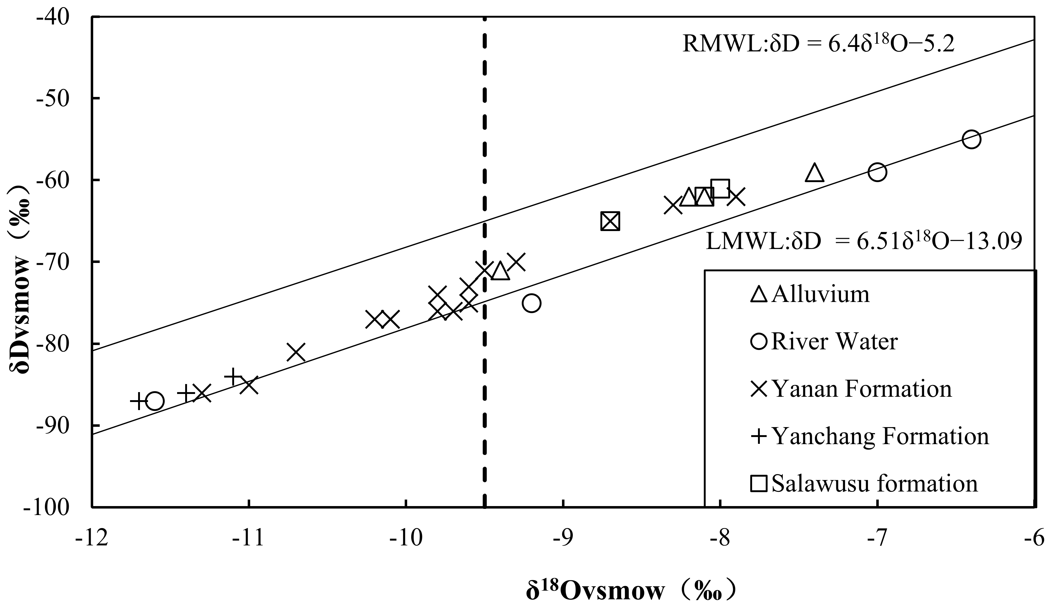
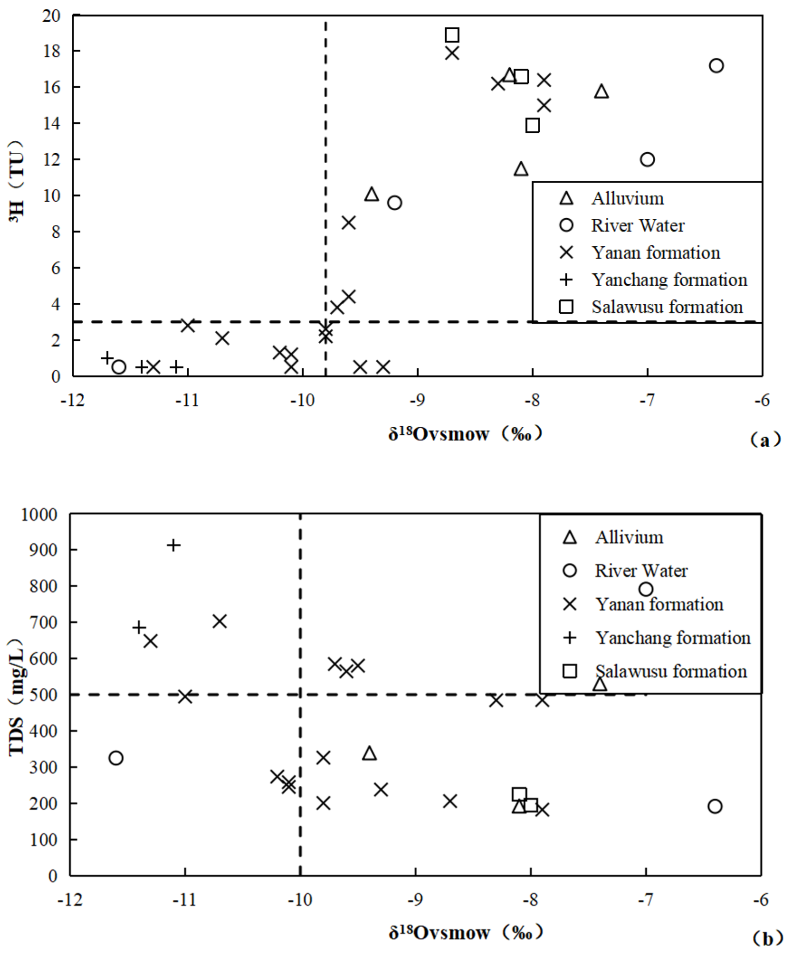
4.2. Hydrogen and Oxygen Stable Isotopic Characteristics

There is a wealth of research on hydrogen and oxygen stable isotopes in precipitation near the study area. Liu [41] collected rainwater isotope data from Ordos and its surrounding areas (including data from the International Atomic Energy Agency and provincial and regional monitoring stations) and developed the Regional Meteoric Water Line (RMWL) equation.
δD = 6.4δ18O − 5.2
The number of precipitation samples (n) is 120, with a goodness of fit (R2) of 0.91.
The average values of δ18O and δDin atmospheric precipitation in the region are −8.31‰ and −56.70‰, respectively.
Guo Qiaoling [42] and others collected summer precipitation samples about 30 km south of the study area. The equation for the local meteoric water line (LMWL) was determined as follows:
δD = 6.51 δ18O − 13.09 (n = 9).
The average values of δ18O and δD for the LMWL are −9.04‰ and −71.94‰, respectively.
Both the slopes of the two precipitation lines are less than 8, and the intercepts are less than 10, indicating a dry climate in the study area with significant evaporation of precipitation. As shown in Figure 4, the data points of local river water and groundwater are located below the regional precipitation line and on both sides of the local meteoric water line, indicating that the river water and groundwater mainly receive local precipitation recharge and undergo significant evaporation during the recharge process. The range of δ18O in river water is −11.6‰ to −6.4‰, and the range of δD is −87‰ to −55‰. The range of δ18O in groundwater is −11.7‰ to −7.4‰, and the range of δD is −75‰ to −55‰. River water mainly comes from mine drainage, springs, and a small amount of atmospheric precipitation. There is a significant difference in the hydrogen and oxygen stable isotope values of river water, reflecting the differences in the isotope characteristics of the groundwater that recharges it. Overall, the heavy isotopes of the Yan’chang Formation groundwater are poorer than those of the Yan’an Formation groundwater, and the heavy isotopes of the Yan’an Formation groundwater are poorer than those of the Quaternary groundwater, reflecting the differences in the recharge environment. According to previous studies, the climate has generally been warming in the past 30,000 years, indicating that the Yan’chang Formation groundwater is recharged during earlier periods of lower temperatures [43].

4.3. Radiogenic Isotope Characteristics

The values of radiogenic isotopes 3H and 14C can roughly reflect the circulation rate of groundwater [44,45]. The half-life of 3H is 12.32 years, and the half-life of 14C is commonly used as 5730 years. It is generally believed that groundwater recharge before 1952 does not contain tritium (3H), while a 3H content greater than 1TU indicates that groundwater is mainly recharged after 1952.
The regional groundwater has a strong spatial distribution pattern in 3H content. The 3H content in the Quaternary and shallow weathered fracture water of the Yan’an Formation is generally 10–18 TU, indicating a faster cycle. However, the 3H content in the fractured water of the Yan’an Formation bedrock varies greatly, ranging from 0 to 19 TU. The 3H content in the Yan’chang Formation groundwater is less than 1 TU, indicating non-modern groundwater recharge.
The 14C activity of groundwater in the study area ranges from 0.8 to 54 pmC. The Yan’chang Formation groundwater has a very low value of 0.8 pmC, indicating a very low circulation rate. The 14C activity of the shallow Quaternary groundwater is 40–50 pmC, indicating a relatively faster cycle. The 14C activity of the Yan’an Formation groundwater is 15–30 pmC, reflecting a moderate circulation rate. The 14C content of the mixed water samples from the Yan’an Formation and Yan’chang Formation is 15 pmC.

5. Discussion

5.1. Characteristics of Groundwater Circulation

The isotopic and hydrochemical differences in groundwater reflect the changes in water circulation conditions under large-scale coal mining in the study area [46,47]. With a δ18O value of −9.5‰ as the boundary (dashed line in Figure 4), the isotopic and hydrochemical characteristics of groundwater in the study area show significant differences. The δ18O values of the Quaternary groundwater (and most river water) are greater than −9.5‰, and some of the Yan’an Formation groundwater also has δ18O values greater than −9.5‰, indicating good hydraulic connection or similar water circulation characteristics between the Quaternary groundwater and this part of the Yan’an Formation groundwater. This inference can be further supported by the relationship between δ18O and 3H content, as well as the relationship between δ18O and TDS content, as shown in Figure 5a. Points with δ18O values greater than −9.8‰ are distributed in the upper-right corner of the graph, and the 3H content is greater than 3 TU, indicating relatively fast renewal and alternation between the Quaternary groundwater and some of the Yan’an Formation groundwater. Points with δ18O values less than −9.8‰ are distributed in the lower-left corner of the graph, and the 3H content is less than 3 TU, indicating a slower renewal between some of the Yan’an Formation groundwater and the Yan’chang Formation groundwater. As shown in Figure 5b, with a δ18O value of −10‰ as the boundary, points with δ18O values greater than −10‰ are distributed in the lower-right corner of the graph, and the TDS content is less than 500 mg/L, indicating a shorter groundwater infiltration time. Points with δ18O values less than −10‰, on the other hand, have a TDS content mostly greater than 500 mg/L, indicating a longer infiltration time.
Chen and Zhang [48,49] et al. studied the change in roof strata crack due to mining activities and directed the change in aquifer permeability. Ma et al. [10] identified the mechanism of the aquifer due to mining activities and explained that mining activities have led to water-flowing fracture zone development and that the state of the aquifer has been compromised. These studies could help to prove the viewpoints of this study.
Combining the hydrogeological conditions of the study area with the hydrochemical and isotopic characteristics mentioned above reflects the hydraulic connection between aquifers and their recharge capacity. There are no stable and continuous aquitards between the Yan’an Formation and the overlying Quaternary aeolian sand and alluvial deposits in the study area. After atmospheric precipitation infiltrates into the subsurface through the permeable Quaternary loose layer, it directly enters the sandstone aquifer through the weathered fractures in the upper layer of the Yan’an Formation. Therefore, the groundwater recharge rate in this part of the Yan’an Formation is relatively fast, with δ18O values greater than −10‰ (close to the δ18O values of local precipitation), TDS concentrations less than 500 mg/L, and 3H concentrations greater than 3 TU. The mudstone at the bottom of the Yan’an Formation has good aquitard properties, so the chemical and isotopic characteristics of the groundwater in the Yan’an Formation are significantly different from those in the underlying Yan’chang Formation, and there is no hydraulic connection between them.
It was previously believed that there were three relatively confined aquifers in the Yan’an Formation, and groundwater flows along the stratigraphic dip within the sandstone aquifers. This investigation found that the groundwater level burial depth in the Yan’an Formation can be significantly divided into two groups, with one group having a burial depth of less than 10 m and the other group having a burial depth of greater than 40 m. The hydrochemical and isotopic characteristics of the two groups are basically consistent with the characteristics defined by δ18O values of −9.5‰ to −10‰, indicating that the connectivity of the aquifers has increased after the destruction of regional aquitards due to coal mining. A total of 20 sets of water samples were used for this analysis: 15 sample sets have 3H concentrations of more than 1 TU and 5 sample sets have 3H concentrations of less than 1 TU. Only a few Yan’an Formation groundwater samples have 3H concentrations of less than 1 TU, indicating that the confinement of the Yan’an Formation has been compromised and recharge has increased. Precipitation and shallow groundwater can recharge the deep Yan’an Formation through vertical infiltration. Therefore, the occurrence conditions of groundwater in the Yan’an Formation have undergone significant changes and can be generalized as having a shallow layer and a deep layer.

5.2. Conceptual Model of Groundwater Circulation

The age of groundwater intuitively reflects the speed and renewal capacity of groundwater circulation and is one of the key components of the groundwater circulation model [50]. Based on the known initial input concentration of a certain radioactive isotope, the age of groundwater can be calculated using the radioactive decay equation.
t = −1/λln(A/A0)
where t is the age of groundwater; λ is the decay constant of the radioactive isotope (3H or 14C), with a decay constant of 0.05626/a for 3H and 1.2096 × 10⁻⁴/a for 14C; A is the content of the radioactive isotope (3H or 14C) in the sample; and A0 is the content of 3H or 14C in the groundwater at recharge.
The 3H content of precipitation in this study mainly refers to references [51,52], and the initial 14C content of groundwater is determined to be 36.5 pmC by extrapolation based on the relationship between 3H and 14C contents [18].
The estimated ages of groundwater based on 3H content are shown in Table 2.
The calculated 14C ages of the Yan’an Formation groundwater range from 0 to 7700 years, and the age of the Yan’chang Formation (Z2-2) groundwater is 32,000 years.
To analyze the groundwater circulation pattern in the study area, the hydrochemical and isotopic characteristics were generalized and plotted along the typical profile A-B (Figure 2), as shown in Figure 6. Based on the spatial distribution characteristics of the hydrochemical and isotopic features of the groundwater in the study area, it is generalized as a three-level flow system controlled via topographic and geological conditions, namely, shallow, intermediate, and deep.
(1)
Shallow Quaternary Pore–Yan’an Formation Weathered Fracture Flow System: The shallow layer has a well-developed pore–fracture system, good conditions for infiltration recharge from precipitation, and fast groundwater circulation and renewal. The age of groundwater generally ranges from 0 to 20 years, with a circulation depth of 10 to 50 m. This flow system is scattered and mainly based on secondary valleys as discharge reference planes. The TDS concentration of groundwater is generally less than 300 mg/L, and the hydrochemical type is HCO3-Ca.
(2)
Intermediate Yan’an Formation Fracture–Pore Flow System: The development of pore–fracture is relatively poor and heterogeneous. Groundwater recharge takes a longer process, and the circulation renewal is slower. The age of groundwater increases gradually from the top of hills to river valleys, with a maximum age of approximately 6000 years and a circulation depth of 50 to 150 m. This flow system is continuously distributed, mainly relying on the Beiniuchuan River and its main tributaries as discharge reference planes. The TDS concentration of groundwater ranges from 200 to 500 mg/L, and the hydrochemical type is mainly HCO3.
(3)
Deep Yan’chang Formation Fracture–Pore Flow System: The development conditions for pore–fracture are extremely poor. Groundwater recharge takes a long time, and the renewal is very slow. The age of groundwater can reach tens of thousands of years. The main recharge of groundwater occurs in the eastern outcrop area of the Yan’chang Formation in the study area, flowing downstream along the stratigraphic dip. The circulation depth of groundwater is generally deeper than 100 to 150 m, and in the low-lying areas of valleys, it can be deeper than 50 m. The hydrochemical type of groundwater is Cl-Na.

6. Conclusions

The sources of groundwater recharge in the study area are local atmospheric precipitation. The Quaternary strata and the shallow Yan’an Formation are well connected hydraulically, and groundwater is recharged through the surface loose sand layer and the fractured Yan’an Formation. Various levels of valleys serve as discharge reference planes for groundwater, which is discharged to rivers (beds) in the form of springs or subsurface flow, ultimately converging in the Beiniuchuan River.

Author Contributions

Investigation, formal analysis, data curation, and writing—original draft, L.C.; investigation, supervision, and writing—review and editing, P.Z.; supervision, P.L.; investigation, X.G.; investigation, W.Z.; investigation, L.M. All authors have read and agreed to the published version of the manuscript.

Funding

This research was supported by the State Key Program of the National Natural Science Foundation of China (41130637) and the China Geological Survey Project (DD20230432 and DD20230509).

Data Availability Statement

The authors confirm that the data supporting the findings of this study are available within the article.

Acknowledgments

We would like to thank the professional reviewers and the editors.

Conflicts of Interest

The authors declare no conflict of interest.

References

  1. Hong, G.; Ma, F.S.; Guo, J.; Li, K.P.; Lu, R. Assessment of Water Sources and Mixing of Groundwater in a Coastal Mine: The Sanshandao Gold Mine, China. Mine Water Environ. 2018, 37, 351–365. [Google Scholar]
  2. Li, P.Y.; Qian, h.; Wu, J.H.; Zhang, Y.Q.; Zhang, H.B. Major Ion Chemistry of Shallow Groundwater in the Dongsheng Coalfield, Ordos Basin, China. Mine Water Environ. 2013, 32, 195–206. [Google Scholar] [CrossRef]
  3. Yue, H.; Chen, C. Study of Hydrogeological Characteristics and roundwater Circulation Pattern in Shendong Mining Area. Coal Technol. 2017, 36, 113–115. [Google Scholar]
  4. Fu, C.C.; Li, X.Q.; Ma, J.F.; Liu, L.X.; Gao, M.; Bai, Z.X. A hydrochemistry and multi-isotopic study of groundwater origin and hydrochemical evolution in the middle reaches of the Kuye River basin. Appl. Geochem. 2018, 98, 82–93. [Google Scholar] [CrossRef]
  5. Fan, L.M.; Ma, X.D.; Ji, R.J. Progress in engineering practice of water-preserved coalmining in western eco-environment frangible area. J. China Coal Soc. 2015, 40, 1711–1717. [Google Scholar]
  6. Gu, D.Z. Theory framework and technological system of coal mine underground reservoir. China Coal Soc. 2015, 40, 239–246. [Google Scholar]
  7. Zhang, M.S.; Dong, Y.; Du, R.J.; Gu, X.F. The strategy and influence of coal mining on the groundwater resources at the energy and chemical base in the north of Shaanxi. Earth Sci. Front. 2010, 17, 235–246. [Google Scholar]
  8. Zhang, D.S.; Fan, G.W.; Ma, L.Q.; Wang, X.F. Aquifer protection during long wall mining of shallow coal seams: A case study in the Shendong Coalfield of China. Int. J. Coal Geol. 2011, 86, 190–196. [Google Scholar] [CrossRef]
  9. Wang, Z.R. Study on coal mine hydro-geological classification standards in Shendong Mining Area. Saf. Incoal Mines 2017, 47, 86–89. [Google Scholar]
  10. Ma, J.F.; Li, X.Q. Study on models of aquifer failure caused by coal mining in Shendong Mining Area. Coal Sci. Technol. 2019, 47, 207–213. [Google Scholar]
  11. Zhao, D.J.; Liu, Y.M.; Sun, Y.H.; Zhao, Y.; Bai, F.T. Experiments and simulations of underground artificial freezing with the use ofnatural cold resources in cold regions. Build. Environ. 2015, 87, 224–233. [Google Scholar] [CrossRef]
  12. Qiao, X.J.; Li, G.M.; Li, M.; Zhou, J.L.; Du, J.; Sun, Z.H. Influence of coal mining on regional karst groundwater system: A case study in west mountain area of Taiyuan city, nouthern China. Environ. Earth Sci. 2011, 64, 1525–1535. [Google Scholar] [CrossRef]
  13. Barbieri, M.; Barberio, M.D.; Banzato, F.; Billi, A.; Boschetti, T.; Franchini, S.; Gori, F.; Petitta, M. Climate change and its effect ongroundwater quality. Environ. Geochem. Health 2021, 45, 1133–1144. [Google Scholar] [CrossRef] [PubMed]
  14. Herczeg, A.L.; Leaney, F.W. Review: Environmental-Tracers in Arid-Zone Hydrology. Hydrogel. J. 2011, 19, 17–29. [Google Scholar] [CrossRef]
  15. Liu, P.; Hoth, N.; Drebenstedt, C.; Sun, Y.J.; Xu, Z.M. Hydro-geochemical paths of ulti-layer groundwater system in coalmining regions—Using multivariate statistics and geochemical modeling approaches. Sci. Total Environ. 2017, 601–602, 1–14. [Google Scholar] [CrossRef] [PubMed]
  16. Qian, J.Z.; Peng, Y.X.; Zhao, W.D.; Ma, L.; He, X.R.; Lu, Y.H. Hydrochemical processes and evolution of karst groundwater in thenortheastern Huaibei Plain, China. Hydrogeol. J. 2018, 26, 1721–1729. [Google Scholar] [CrossRef]
  17. Huang, Q.B.; Qin, X.Q.; Yang, Q.Y.; Liu, P.Y.; Zhang, J.S. Identification of dissolved sulfate sources and the role of sulfuric acid incarbonate weathering usingδ13CDICandδ34S in karst area, northern China. Environ. Earth Sci. 2016, 75, 51. [Google Scholar]
  18. Qu, S.; Wang, G.C.; Shi, Z.M.; Xu, Q.Y.; Guo, Y.Y.; Ma, L.; Sheng, Y.Z. Using stable isotopes (δD, δ18O, δ34S and δ87Sr/δ86Sr) to identify sources of water in abandoned mines in the Fengfeng coal mining district, northern China. Hydrogeol. J. 2018, 26, 1443–1453. [Google Scholar] [CrossRef]
  19. Chen, J.S.; Liu, X.Y.; Wang, C.Y.; Rao, W.B.; Tan, H.B.; Dong, H.Z.; Sun, X.X.; Wang, Y.S.; Su, Z.G. Isotopic constraints on the origin of groundwater in the Ordos Basin of northern China. Environ. Earth Sci. 2012, 66, 505–517. [Google Scholar] [CrossRef]
  20. Jia, Y.F.; Guo, H.M.; Xi, B.D.; Jiang, Y.H.; Zhang, Z.; Yuan, R.X.; Yi, W.X.; Xue, X.L. Sources ofgroundwater salinity and potential impact on arsenic mobility in the western Hetao Basin, Inner Mongolia. Sci. Total Environ. 2017, 601–602, 691–702. [Google Scholar] [CrossRef]
  21. Yin, L.H.; Hou, G.C.; Su, X.S. Isotopes (δD and δ18O) in precipitation, groundwater and surface water in the Ordos Plateau, China: Implications with respect to groundwater recharge and circulation. Hydrogeol. J. 2011, 19, 429–443. [Google Scholar] [CrossRef]
  22. Huang, T.M.; Ma, B.Q.; Pang, Z.H.; Li, Z.; Li, Z.B.; Yin, L. How does precipitation recharge groundwater in loess aquifers: Evidence from multiple environmental tracers. J. Hydrol. 2020, 583, 124532. [Google Scholar] [CrossRef]
  23. Dong, W.H.; Kang, B.; Du, S.H.; Shi, X.F. Estimation of shallow groundwater ages and circulation rates in the Henan Plain, China: CFC and deuterium excess methods. Geosci. J. 2013, 17, 479–488. [Google Scholar] [CrossRef]
  24. Sherif, M.I.; Sultan, M.; Sturchio, N.C. Chlorine isotopes astracers of solute origin and age of groundwaters from the EasternDesert of Egypt. Earth Planet. Sci. Lett. 2019, 510, 37–44. [Google Scholar] [CrossRef]
  25. Ma, Z.Y.; Zhang, X.L.; He, D. A Study of 36Cl age for the deep geothermal water in the Guanzhong Basin. Hydrogeol. Eng. Geol. 2016, 43, 157–163. [Google Scholar]
  26. Wang, J.Y.; Chen, J.S.; Lu, B.H.; Tong, H.B.; Tan, Z.C.; Sun, Y.Y.; Lin, T.; Wang, Y.S. Review and prospect ofisotopehydrology. J. Hohai Univ. 2015, 43, 406–413. [Google Scholar]
  27. Shi, X.F.; Dong, W.H.; Li, M.Z.; Yan, Z. Evaluation of groundwater renewability in the Henan Plains, China. Geochem. J. 2012, 46, 107–115. [Google Scholar] [CrossRef]
  28. Huang, T.M.; Ma, B.Q. The origin of major ions of groundwater in a loess aquifer. Water 2019, 11, 2464. [Google Scholar] [CrossRef]
  29. Zhang, C.C.; Li, X.Q.; Ma, J.F.; Wang, Z.X.; Hou, X.W. Stable isotope and hydrochemical evolution of shallow groundwater in mining area of the Changzhi Basin, northern China. Environ. Earth Sci. 2022, 81, 294. [Google Scholar] [CrossRef]
  30. Su, X.S.; Xu, W.; Yang, F.T.; Zhu, P.C. Using new mass balance methods to estimate gross surface water and groundwater exchange with naturally occurring tracer222Rn in data poor regions: A case study in northwest China. Hydrol. Process. 2015, 29, 979–990. [Google Scholar] [CrossRef]
  31. Li, J.; Pang, Z.H.; Yang, G.M.; Tian, J.; Tong, A.L.; Zhang, X.Y.; Hu, S.M. Million-year-old groundwater revealed by krypton-81 dating in Guanzhong Basin, China. Sci. Bull. 2017, 62, 1181–1184. [Google Scholar] [CrossRef] [PubMed]
  32. Liu, F.; Song, X.F.; Yang, L.H.; Han, D.M.; Zhang, Y.H.; Ma, Y.; Bu, H.M. The role of anthropogenic and natural factors in shaping the geochemical evolution of groundwater in the Subei Lake basin, Ordos energy base, Northwestern China. Sci. Total Environ. 2015, 538, 327–340. [Google Scholar] [CrossRef] [PubMed]
  33. Yin, L.H.; Hou, G.C.; Dou, Y.; Tao, Z.P.; Li, Y. Hydrogeochemical and isotopic study of groundwater in the habor lake basin of the Ordos plateau, NW China. Environ. EarthSci. 2011, 64, 1575–1584. [Google Scholar] [CrossRef]
  34. Chen, X.H.; Guo, Q.L.; Chen, Z.H. The runoff variation characteristic and influencing factors in Beiniuchuan River. J. Arid. Land Resour. Environ. 2015, 29, 186–191. [Google Scholar]
  35. Bian, Z.F.; Lei, S.G.; In, H.; Chang, L.Q.; Zhang, R.C.; Zhou, C.J.; He, X. Integrated method of RS and GPR for monitoring the changes in the soil moisture and groundwater environment due to underground coal mining. Environ. Geol. 2009, 57, 131–142. [Google Scholar] [CrossRef]
  36. Miao, X.X.; Wang, C.S.; Bai, H.B. Hydrogeologic characteristics of mine water hazards in Shendong mining area. Min. Saf. Eng. 2010, 27, 285–291. [Google Scholar]
  37. Ma, L.Q.; Zhang, D.S.; Jia, J.L.; Zhao, Y.S.; Cao, X.Q.; Bo, Z.P.; Zhao, Y.F. The recycling mode and technique of water in desertification area of Shendong Coal Mine. Energy Procedia 2012, 14, 20–25. [Google Scholar]
  38. Tao, X.; Zhang, G.; Qiao, J. A genetic discussion on coal sulfur and ash in Jurassic north Shaanxi and Huanglong coalfields. Coal Geol. China 2012, 24, 11–14. [Google Scholar]
  39. Lee, C.L.; Chin, K.L.; H’ng, P.S.; Rashid, U.; Maminski, M.; Khoo, P.S. Effect of pretreatment conditions on the chemical-structural characteristics of coconut and palm kernel shell: A potentially valuable precursor for eco-efficient activated carbon production. Environ. Technol. Innov. 2021, 21, 101309. [Google Scholar] [CrossRef]
  40. Li, T.K.; Liu, B.S.; Bi, X.H.; Wu, J.H.; Zhang, Y.F.; Feng, Y.C. Size and chemical characteristics of particles emitted from typical rural biomass cookstoves in North China. Atmos. Res. 2021, 249, 105295. [Google Scholar] [CrossRef]
  41. Liu, J.; Guo, H.L.; Liu, F.L.; Wei, W.; Zhang, L.; Zhang, X.Y. The variations of stable isotopes (δD and δ18O) inthe precipitation in Baotou area. J. Arid. Land. Resour. Environ. 2013, 27, 157–162. [Google Scholar]
  42. Guo, Q.L.; Xiong, X.Z.; Jiang, J.R. Analysis of isotopic and hydrochemical charicteristics of different water in Kuye River Basin. J. Soil. Water Conserv. 2016, 30, 237–242. [Google Scholar]
  43. Liu, F.; Wang, S.; Wang, L.S.; Shi, L.M.; Song, X.F.; Yeh, T.C.; Zhen, P.N. Coupling hydrochemistry and stable isotopes to identify the major factors affecting groundwater geochemical evolution in the Heilongdong Spring Basin, North China. J. Geochem. Explor. 2019, 205, 106352. [Google Scholar] [CrossRef]
  44. Ruan, Y.F.; Zhao, L.J.; Xiao, H.L.; Zhou, M.X.; Cheng, G.D. The groundwater in the Heihe River basin: Isotope age and renewability. J. Glaciol. Geocryol. 2015, 37, 767–782. [Google Scholar]
  45. Wan, Y.Y.; Su, X.S.; Dong, W.H. Evaluation of groundwater renewal ability in the Ordos Cretaceous groundwater basin. J. Jilin Univ. (Earth Sci. Ed.) 2010, 40, 623–630. [Google Scholar]
  46. Tang, C.L.; Jin, H.; Liang, Y.P. Using Isotopic and Hydrochemical Indicators to Identify Sources of Sulfate in Karst Groundwater of the Niangziguan Spring Field, China. Water 2021, 13, 390. [Google Scholar] [CrossRef]
  47. Guo, Y.Y.; Lyu, Z.C.; Wang, G.C.; Ma, L.; Xu, Q.Y.; Huang, X.J.; Gao, S.Z. Hydrogeochemical simulation of groundwater in Eastern Fengfeng mining area. Coal Geol. Explor. 2016, 44, 101–105. [Google Scholar]
  48. Chen, L.; Zhang, F.W.; Yao, H.C.; Han, Z.T.; Qian, L.; Chen, L.; Jiang, C.C. Using of key stratum theory to study the structural development of roof aquifer. ACTC Geol. (Engl. Ed.) 2015, 89, 2090–2093. [Google Scholar]
  49. Zhang, F.W.; Chen, L.; Yao, H.C. Progress of hydrogeological research in mining areas and its mid-and long-term trend. ACTC Geologica Sinnca (Chin. Ed.) 2016, 90, 2464–24753. [Google Scholar]
  50. Huang, T.M.; Pang, Z.H.; Li, J.; Xiang, Y.; Zhao, Z.J. Mapping ground water renewability using age data in the Baiyang Alluvial Fan, NWChina. Hydrogeol. J. 2017, 25, 743–755. [Google Scholar] [CrossRef]
  51. Hou, G.C. Groundwater system and Water Circulation Patter in Ordos Cretaceous Groundwater Basin. Ph.D. Thesis, Jilin University, Changchun, China, 2008. [Google Scholar]
  52. Liu, F.T. Research on Groundwater Circulation and Hydrochemical Transport in the North of Ordos Cretaceous Basin Based on Isotope Technology. Ph.D. Thesis, Jilin University, Changchun, Chian, 2008. [Google Scholar]
Figure 1. Hydrogeological profile of Beiniuchuan River valley. 1—gravel pebble; 2—silty fine sand; 3—floury soil; 4—sandstone; 5—sandy mudstone; 6—mudstone; 7—unconfined water line.
Water 15 04000 g001
Figure 2. The location of sample points.
Water 15 04000 g002
Figure 3. Piper diagram of hydrochemical characteristics of groundwater.
Water 15 04000 g003
Figure 4. O-δD relationship between river water and groundwater in the study area.
Water 15 04000 g004
Figure 5. Relationship between δ18O and 3H content of groundwater (subfigrues (a)), and relationship between δ18O and TDS content (subfigrues (b)).
Water 15 04000 g005
Figure 6. Conceptual model of groundwater circulation in the study area.
Water 15 04000 g006
Table 1. Results of hydrochemical environmental isotopes of groundwater in the study area.
NumberSampleWell DepthWater DepthTDSHydrochemical Typeδ2Hδ18O3H14C
Layer(m)/m(mg/L) (‰)(‰)(TU)(pmC)
275River water −75−9.29.6
235River water 191.1HCO3-Ca·Mg−55−6.417.2
370River water 791.6HCO3·SO4-Na·Ca−59−712
202River water 324.7HCO3·SO4-Ca·Na−87−11.6<1
20Q4al+pl43.5250.7HCO3-Ca·Mg
40Q4al+pl4.22.61410.4HCO3·SO4-Ca·Na
29Q4al+pl162.19192HCO3-Ca−62−8.111.5
232Q4al+pl83.95339.1HCO3·SO4-Ca−71−9.410.1
255Q4al+pl127.27530.2HCO3·NO3-Ca−59−7.415.8
106Q3s 224HCO3-Ca−62−8.116.6
328J1–2y1206.9485HCO3·SO4-Ca·Na−62−7.91554.14
176J1–2y125.77580.1SO4·HCO3-Ca·Na−71−9.5<1
209J1–2y4.53245.7HCO3-Ca·Mg
329J1–2y62.6484.5HCO3·SO4-Ca·Mg−63−8.316.2
49J1–2y3023.47755.2HCO3·SO4-Ca
308J1–2y1408507.7HCO3·SO4-Na
32J1–2y1005.3624.9HCO3·SO4-Ca·Na
51J1–2y1003.89842.9SO4·HCO3-Ca·Na
28J1–2y1303.9564.4SO4·HCO3-Na−75−9.64.4
34J1–2y8360.5325.7HCO3-Na−76−9.82.228.19
58J1–2y150105244.7HCO3-Na−77−10.1<132.43
168J1–2y10060.5494.7HCO3-Na−85−112.816.85
190J1–2y14059.84181.9HCO3-Ca·Mg−62−7.916.4
242J1–2y15080273.2HCO3-Na·Ca−77−10.21.324.52
268J1–2y13037.25237.5HCO3-Ca·Mg−70−9.3<1
283J1–2y16080257.9HCO3-Na·Ca·Mg−77−10.11.228.7
113J1–2y12072.29703.1Cl-HCO3·Na−81−10.72.114.35
143J1–2y12068.3556.1SO4·HCO3·Cl-Ca·Na
358J1–2y15017.44584.7HCO3·Cl-Na−76−9.73.8
Z1J1–2y20035 −65−8.718.939.92
361J1–2y15065557.8HCO3·Cl-Na
Z2-1J1–2y8018 −73−9.68.5
Z2-2T3y2000720.5Cl-Na−87−11.710.8
306J1–2y + T3y20032.4648.4Cl-Na−86−11.3<115.44
317J1–2y + T3y1508.4620.7Cl-Na
223T3y1801.5706.4Cl-Na
316T3y1800686.5Cl-Na−86−11.4<1
Table 2. Estimated ages of groundwater based on 3H content.
3H content/TU1~33~88~1312~20
Groundwater age/a>6050~6010~200~10
Disclaimer/Publisher’s Note: The statements, opinions and data contained in all publications are solely those of the individual author(s) and contributor(s) and not of MDPI and/or the editor(s). MDPI and/or the editor(s) disclaim responsibility for any injury to people or property resulting from any ideas, methods, instructions or products referred to in the content.

