


Shrinking Desert Channel Response to Increasing Human Interferences and Changing Natural Factors in the Upper Yellow River


Abstract
:1. Introduction
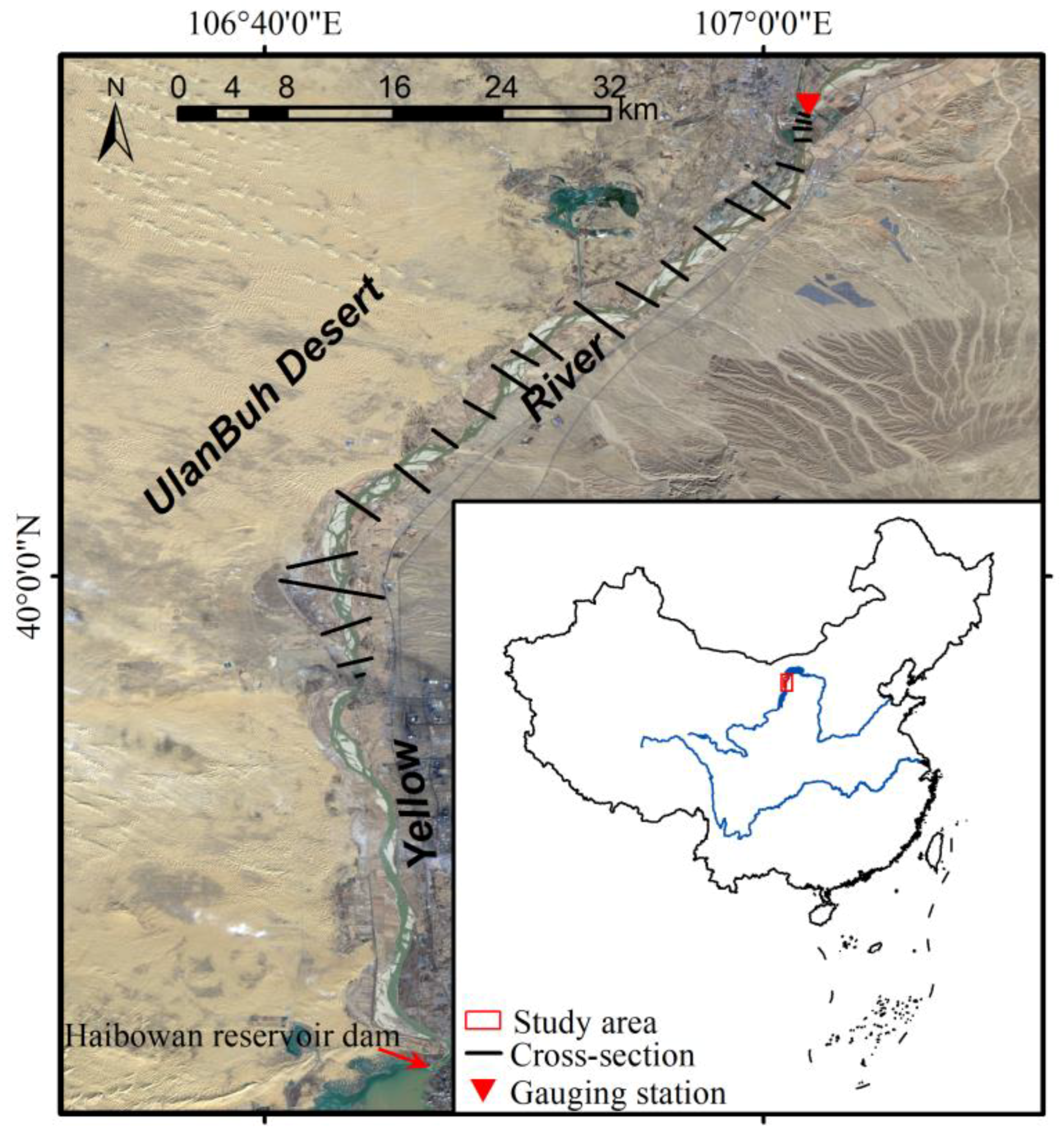
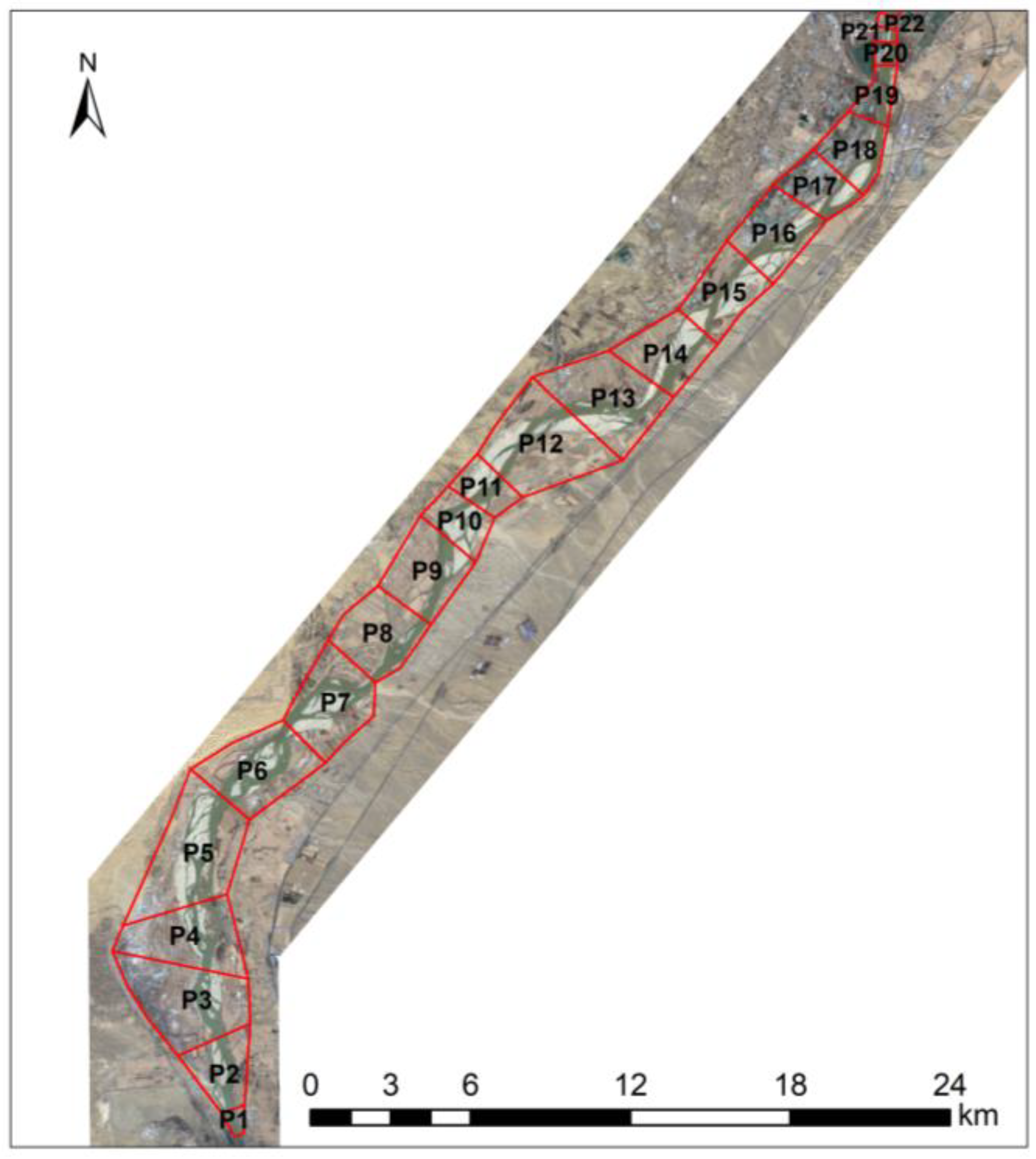
2. Study Area
3. Data and Methods
3.1. Data
3.2. Methods
3.2.1. Mann–Kendall Test
3.2.2. Wavelet Analysis
3.2.3. Estimation of Erosion and Sedimentation
4. Results
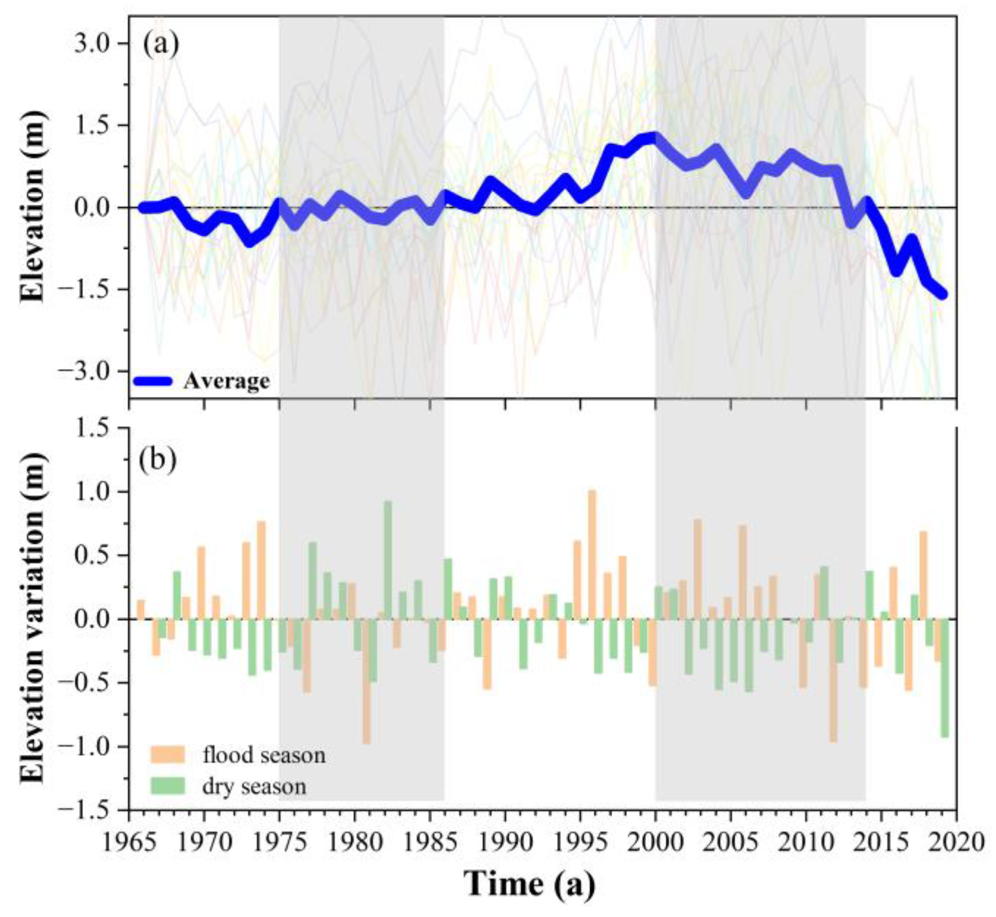
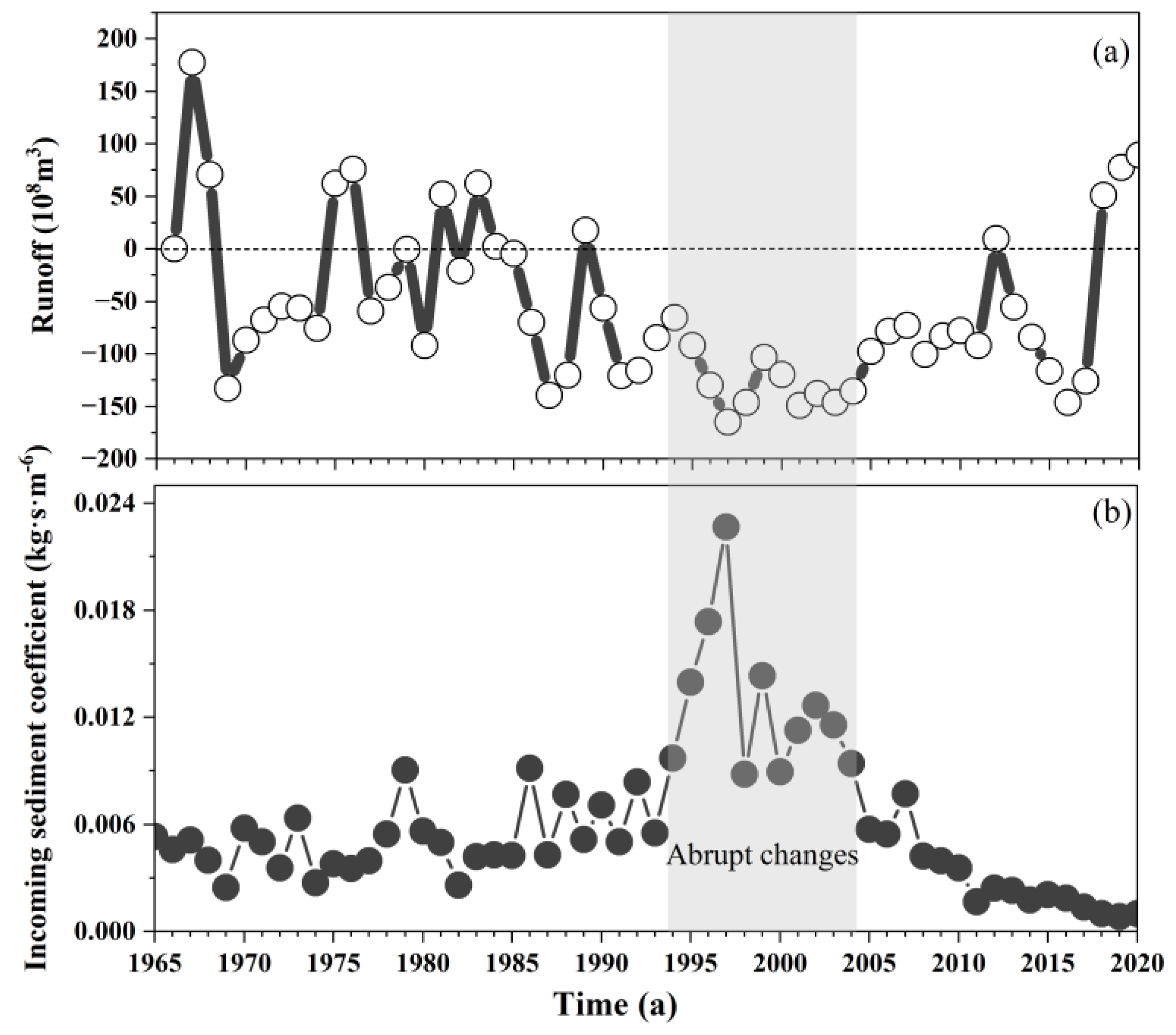
4.1. Channel Scouring–Silting Annual Changes
4.1.1. Talweg
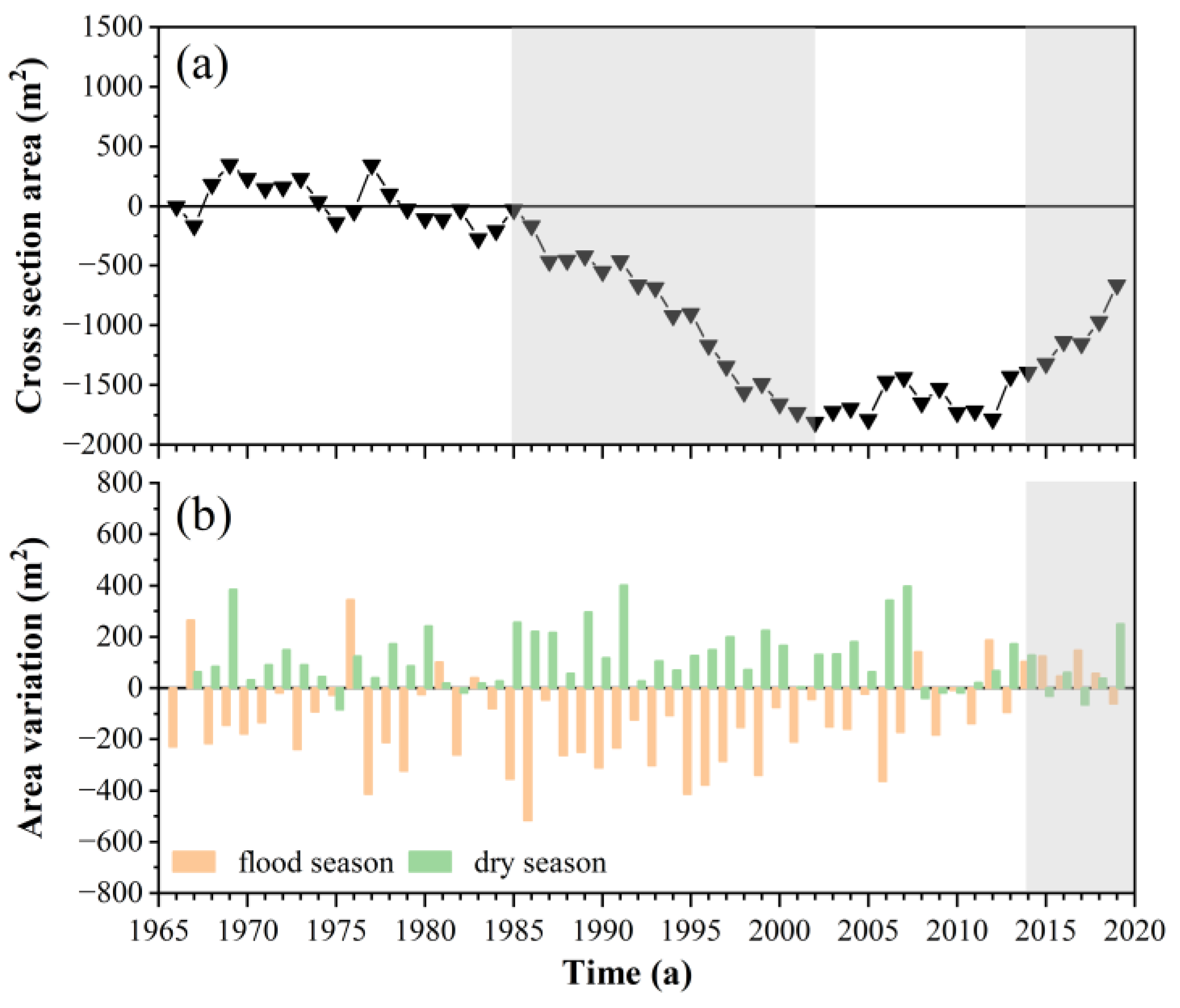
4.1.2. Channel Cross-Section Area
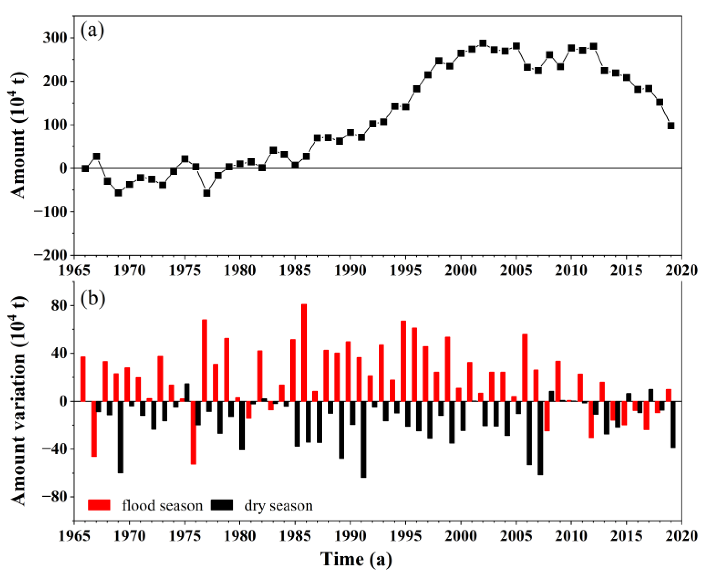
4.1.3. Scouring–Deposition Amount
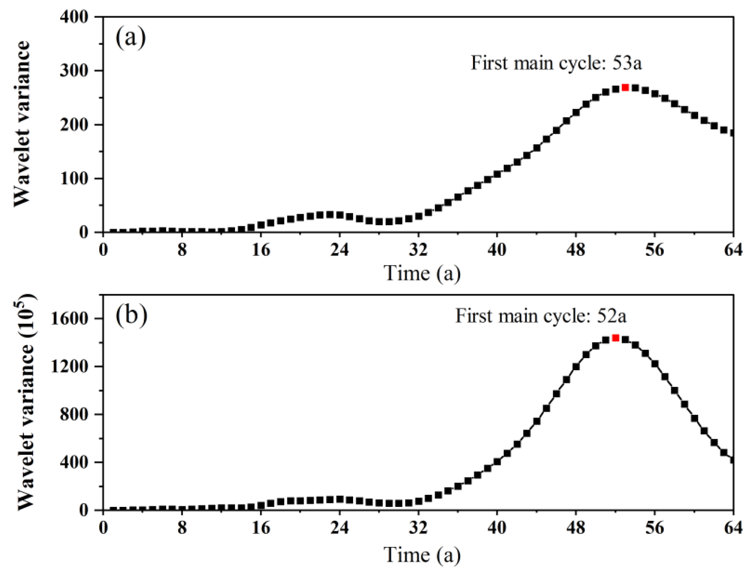
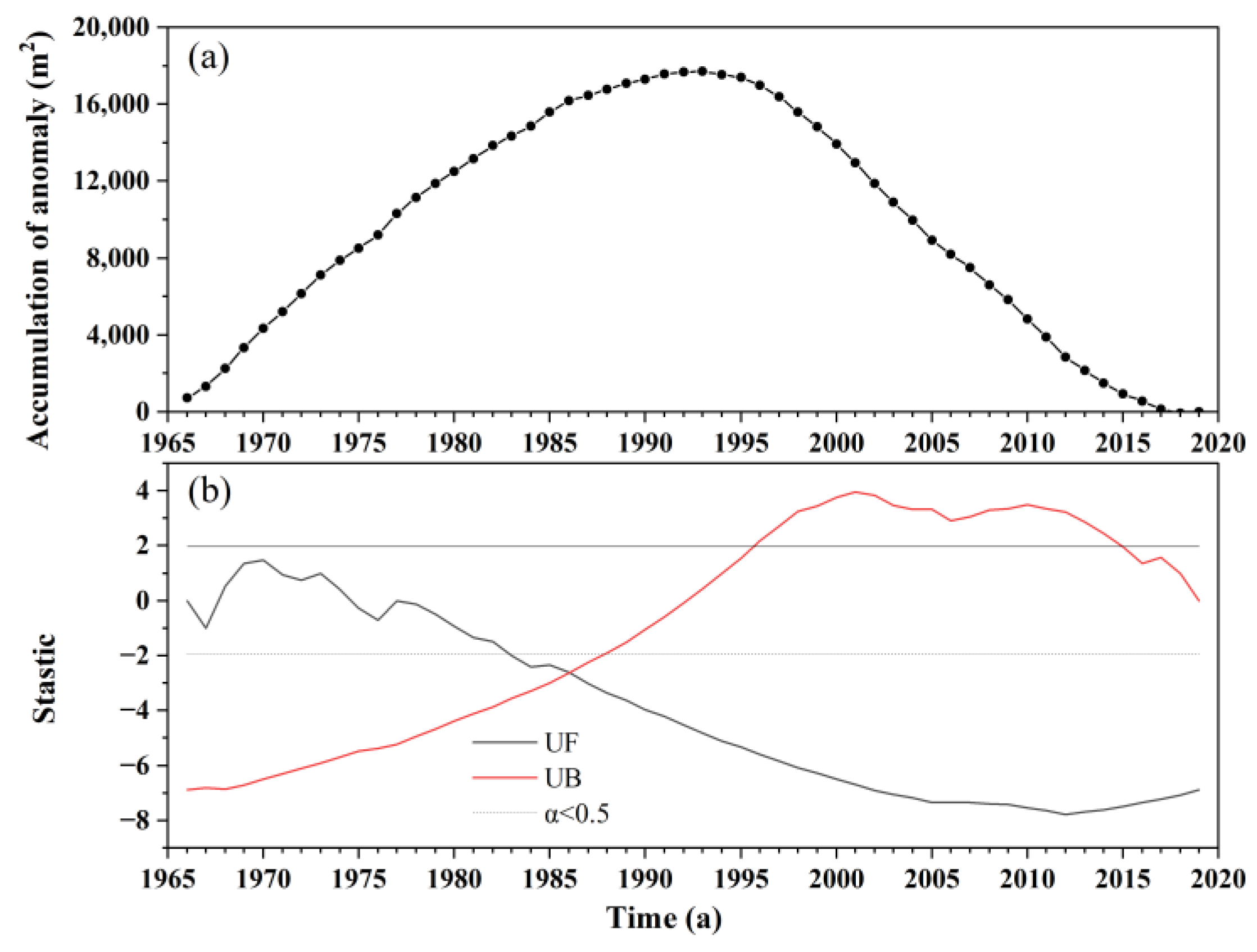
4.2. Evolution Cycle of Scouring–Depositing
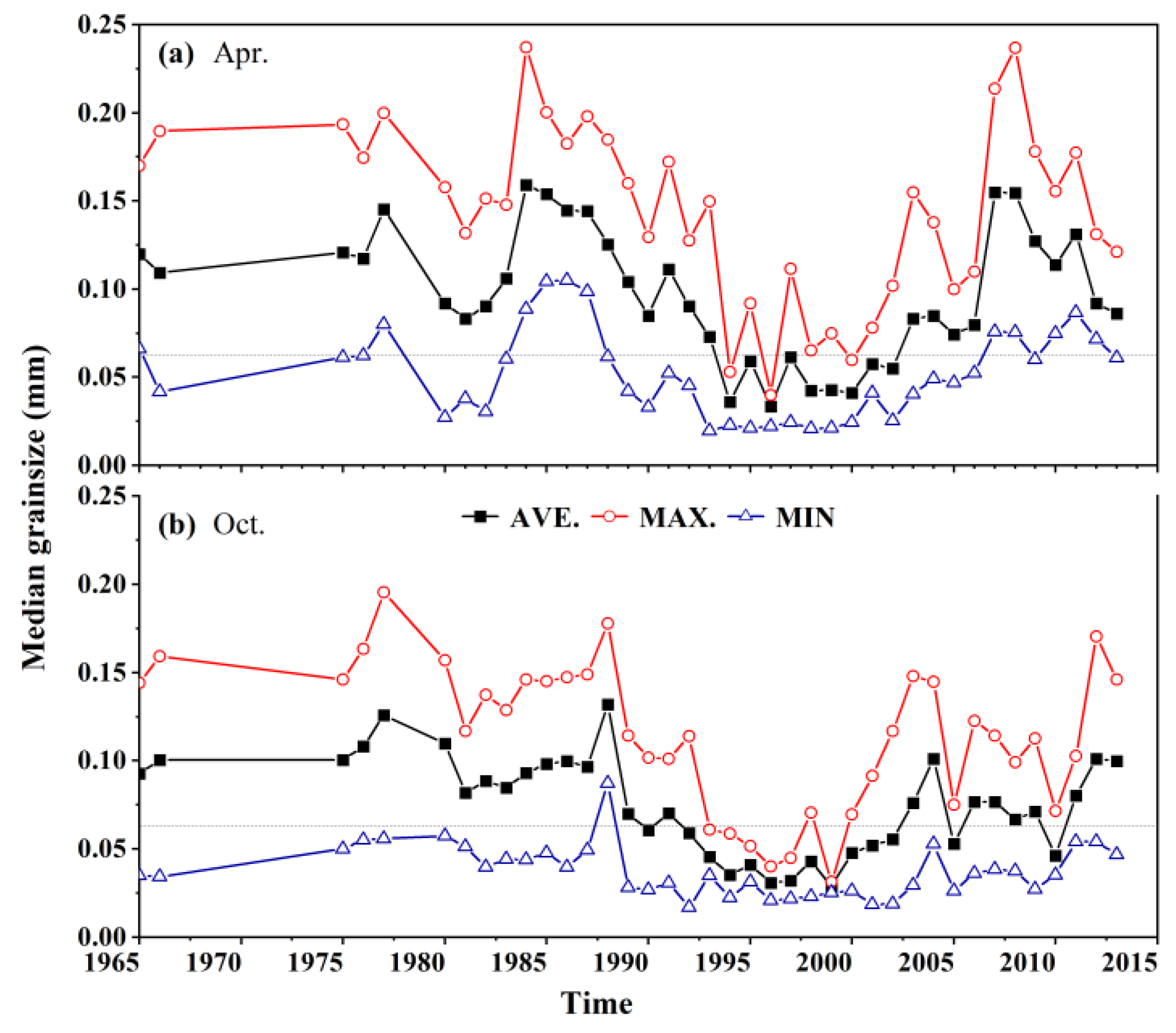
4.3. Bedload Grain Size Changes
5. Discussions
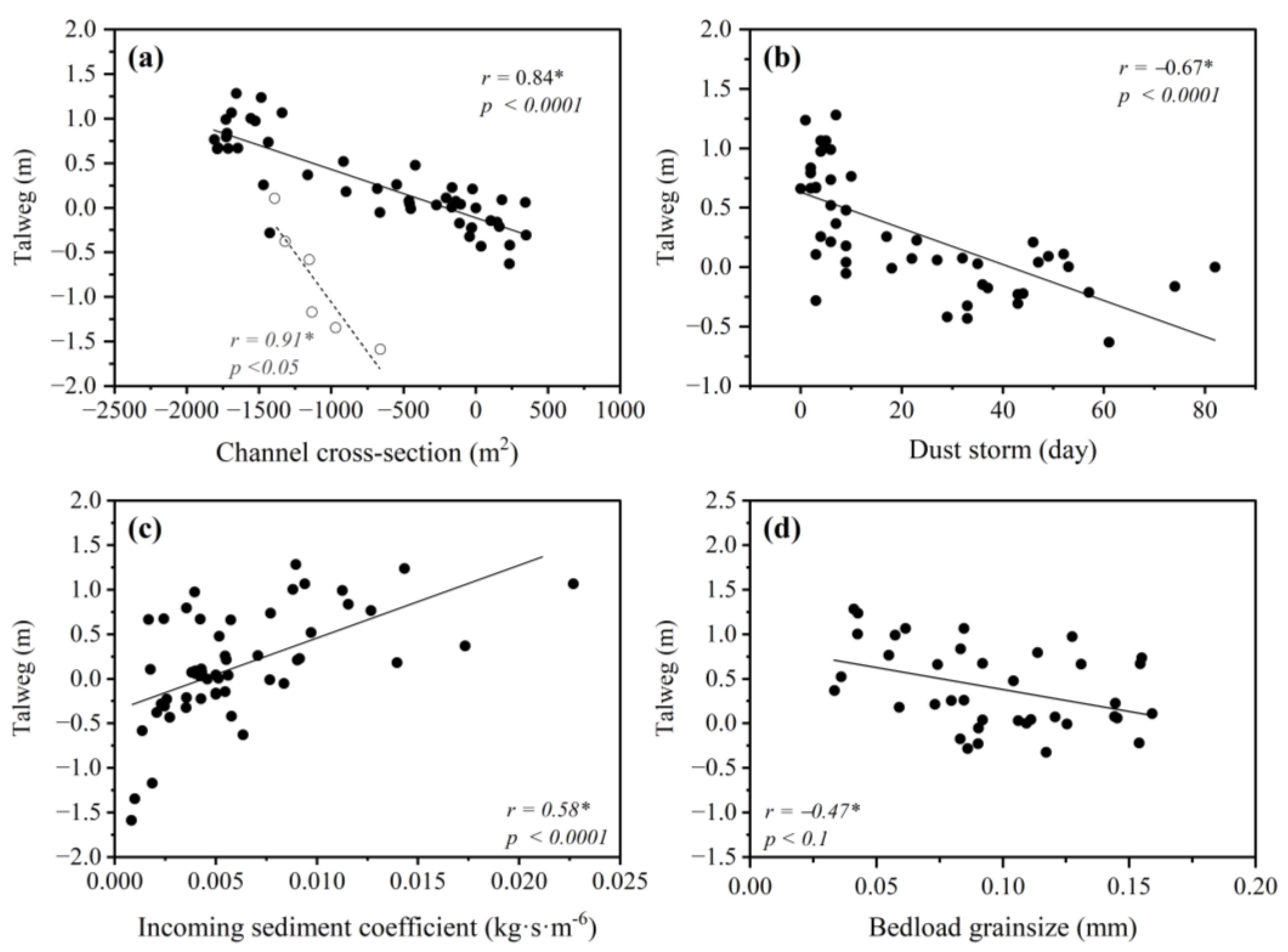
5.1. Relationship between Talweg and River Cross-Section Area
5.2. Bank Ecological Restoration
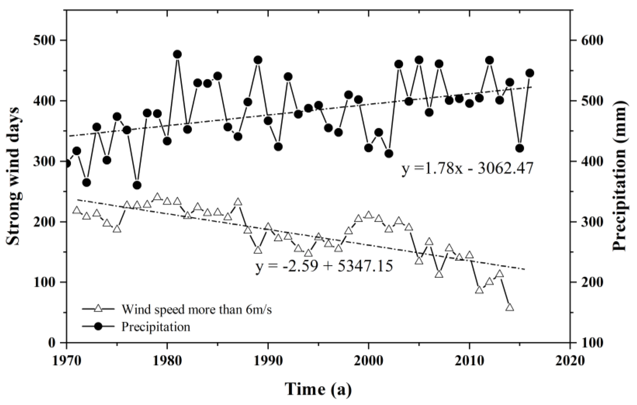
5.3. Aeolian and Fluvial Factors
5.4. Uncertainties and Limitations
6. Conclusions
Author Contributions
Funding
Data Availability Statement
Acknowledgments
Conflicts of Interest
References
- Leopold, L.B.; Wolman, M.G. River Channel Patterns: Braided, Meandering and Straight. Prof. Geogr. 1957, 9, 39–85. [Google Scholar]
- Miall, A.D. A review of the braided-river depositional environment. Earth-Sci. Rev. 1977, 13, 1–62. [Google Scholar] [CrossRef]
- Chang, H.H. Minimum stream power and river channel patterns. J. Hydrol. 1979, 41, 303–327. [Google Scholar] [CrossRef]
- Schumm, S.A. Patterns of alluvial rivers. Annu. Rev. Earth Planet. Sci. 1985, 13, 5. [Google Scholar] [CrossRef]
- Graf, W.L. Channel instability in a braided, sand bed river. Water Resour. Res. 1981, 17, 1087–1094. [Google Scholar] [CrossRef]
- Lane, S.N.; Richards, K.S.; Chandler, J.H. Discharge and sediment supply controls on erosion and deposition in a dynamic alluvial channel. Geomorphology 1996, 15, 1–15. [Google Scholar] [CrossRef]
- Bridge, J.S. The interaction between channel geometry, water flow, sediment transport and deposition in braided rivers. Geol. Soc. Lond. Spec. Publ. 1993, 75, 13–71. [Google Scholar] [CrossRef]
- Frings, R.M. Downstream fining in large sand-bed rivers. Earth-Sci. Rev. 2008, 87, 39–60. [Google Scholar] [CrossRef]
- Wang, S. Channel Pattern Specialities and the Formation of the Lower Reaches of the Yellow River. Acta Geosicientia Sin. 2003, 24, 73–78. [Google Scholar]
- Chien, N. On the Classification and causes of formation of different channel patterns. Acta Geogr. Sin. 1985, 40, 1–10. [Google Scholar]
- Lewin, J.; Brewer, P.A. Predicting channel patterns. Geomorphology 2001, 40, 329–339. [Google Scholar] [CrossRef]
- Sarma, J.N. Fluvial process and morphology of the Brahmaputra River in Assam, India. Geomorphology 2005, 70, 226–256. [Google Scholar] [CrossRef]
- Wang, S.; Fan, X. Flood Processes and Channel Responses in Typical Years of the Different Channel Patterns in Neimenggu Reaches of the Upper Yellow River. Prog. Geogr. 2010, 29, 565–571. [Google Scholar]
- Schumm, S.A. A tentative classification of alluvial river channels. In Proceedings of the United States Geological Survey Circular, Millard County, UT, USA, 1 January 1963. [Google Scholar]
- Sarker, M.H.; Thorne, C.R.; Aktar, M.N.; Ferdous, M.R. Morpho-dynamics of the Brahmaputra–Jamuna River, Bangladesh. Geomorphology 2014, 215, 45–59. [Google Scholar] [CrossRef]
- Vitek, J.D. Geomorphology: Perspectives on observation, history, and the field tradition. Geomorphology 2013, 200, 20–33. [Google Scholar] [CrossRef]
- Arfa-Fathollahkhani, A.; Ayyoubzadeh, S.A.; Shafizadeh-Moghadam, H.; Mianabadi, H. Spatiotemporal Characterization and Analysis of River Morphology Using Long-Term Landsat Imagery and Stream Power. Water 2022, 14, 3656. [Google Scholar] [CrossRef]
- Schuurman, F.; Ta, W.; Post, S.; Sokolewicz, M.; Busnelli, M.; Kleinhans, M. Response of braiding channel morphodynamics to peak discharge changes in the Upper Yellow River. Earth Surf. Process. Landf. 2018, 43, 1648–1662. [Google Scholar] [CrossRef]
- Dissanayake, D.; Roelvink, J. Effect of Sediment Transport Formulation on Long-Term Morphology; European Geophysical Union (EGU): Vienna, Austria, 2008. [Google Scholar]
- Li, J. Development Environment and Evolution Patterns of Linear Dunes in the Qaidam Basin; Xi’an Jiaotong University Press: Xi’an, China, 2020. [Google Scholar]
- Davis, W.M. The geographical cycle. Geogr. J. 1899, 14, 481–504. [Google Scholar] [CrossRef]
- Bagnold, R.A. The Movement of Desert Sand. Geogr. J. 1936, 157, 342–365. [Google Scholar] [CrossRef]
- Tooth, S. Process, form and change in dryland rivers: A review of recent research. Earth-Sci. Rev. 2000, 51, 67–107. [Google Scholar] [CrossRef]
- Yang, H.; Shi, C. Spatial and temporal variations of aeolian sediment input to the tributaries (the Ten Kongduis) of the upper Yellow River. Aeolian Res. 2018, 30, 1–10. [Google Scholar] [CrossRef]
- Al-Masrahy, M.A.; Mountney, N.P. A classification scheme for fluvial-aeolian system interaction in desert-margin settings. Aeolian Res. 2015, 17, 67–88. [Google Scholar] [CrossRef]
- Belnap, J.; Munson, S.M.; Field, J.P. Aeolian and fluvial processes in dryland regions: The need for integrated studies. Ecohydrology 2011, 4, 615–622. [Google Scholar] [CrossRef]
- Liu, B.; Coulthard, T.J. Mapping the interactions between rivers and sand dunes: Implications for fluvial and aeolian geomorphology. Geomorphology 2015, 231, 246–257. [Google Scholar] [CrossRef]
- Breshears, D.D.; Whicker, J.J.; Johansen, M.P.; Pinder, J.E. Wind and water erosion and transport in semi-arid shrubland, grassland and forest ecosystems: Quantifying dominance of horizontal wind-driven transport. Earth Surf. Process. Landf. 2003, 28, 1189–1209. [Google Scholar] [CrossRef]
- Bullard, J.E.; McTainsh, G.H. Aeolian-fluvial interactions in dryland environments: Examples, concepts and Australia case study. Prog. Phys. Geogr. 2003, 27, 471–501. [Google Scholar] [CrossRef]
- Field, J.P.; Breshears, D.D.; Whicker, J.J. Toward a more holistic perspective of soil erosion: Why aeolian research needs to explicitly consider fluvial processes and interactions. Aeolian Res. 2009, 1, 9–17. [Google Scholar] [CrossRef]
- Langford, R.P. Fluvial-aeolian interactions: Part I, modern systems. Sedimentology 2010, 36, 1023–1035. [Google Scholar] [CrossRef]
- Ta, W.; Wang, H.; Jia, X. Downstream fining in contrasting reaches of the sand-bedded Yellow River. Hydrol. Process. 2011, 25, 3693–3700. [Google Scholar] [CrossRef]
- Smith, N.D.; Smith, D.G. William River: An outstanding example of channel widening and braiding caused by bed-load addition. Geology 1984, 12, 78–82. [Google Scholar] [CrossRef]
- Li, S.; Dong, G.; Shen, J.; Yang, P.; Liu, X.; Wang, Y.; Jin, H.; Wang, Q. Formation mechanism and development pattern of aeolian sand landform in Yarlung Zangbo River valley. Sci. Sin. Terrae 1999, 42, 272–284. [Google Scholar] [CrossRef]
- Li, Y.; Wang, H.; Ma, Q. Responses of the Braided Channel to Reduced Discharge and Lateral Inputs of Aeolian Sand in the Ulan Buh Desert Reach of the Upper Yellow River. Environ. Earth Sci. 2018, 77, 379. [Google Scholar] [CrossRef]
- Jia, X.; Wang, H.; Li, Y. Desert channel erosion, accretion characteristics and their implications for aeolian–fluvial interactions: A case study in a desert watershed in the Ordos Plateau, China. Environ. Earth Sci. 2021, 80, 371. [Google Scholar] [CrossRef]
- Wang, H.; Jia, X.; Li, Y.; Peng, W. Selective deposition response to aeolian–fluvial sediment supply in the desert braided channel of the upper Yellow River, China. Nat. Hazards Earth Syst. Sci. 2015, 15, 1955–1962. [Google Scholar] [CrossRef]
- Yang, G.; Ta, W.; Dai, F.; Liu, Y.; Jing, K.; Li, B.; Zhang, O.; Lu, R.; Hu, L.; Tao, Y. Contribution of Sand Sources to the Silting of Riverbed in Inner Mongolia Section of Huanghe River. J. Desert Res. 2003, 23, 54–61. [Google Scholar]
- Jia, X.; Wang, H.; Xiao, J. Geochemical elements characteristics and sources of the riverbed sediment in the yellow river’s desert channel. Environ. Earth Sci. 2011, 64, 2159–2173. [Google Scholar] [CrossRef]
- Pang, H.; Pan, B.; Garzanti, E.; Gao, H.; Zhao, X.; Chen, D. Mineralogy and geochemistry of modern Yellow River sediments: Implications for weathering and provenance. Chem. Geol. 2018, 488, 76–86. [Google Scholar] [CrossRef]
- Yang, G. Symposia on Blown-Sand Disaster; Ocean Press: Beijing, China, 2005. (In Chinese) [Google Scholar]
- Xu, X. China annual vegetation index (NDVI) spatial distribution data set. In Registration and Publication System of Resources and Environmental Science Data; Chinese Academy of Sciences: Beijing, China, 2018. [Google Scholar] [CrossRef]
- Mann, H.B. Nonparametric test against trend. Econometrica 1945, 13, 245–259. [Google Scholar] [CrossRef]
- Kendall, M.G. Rank Correlation Methods; APA: Camberwell, Australia, 1975. [Google Scholar]
- Percival, D.B.; Walden, A.T. Wavelet Methods for Time Series Analysis; Cambridge University Press: Cambridge, UK, 2000. [Google Scholar]
- Kasai, M.; Marutani, T.; Brierley, G. Channel bed adjustments following major aggradation in a steep headwater setting: Findings from Oyabu Creek, Kyushu, Japan. Geomorphology 2004, 62, 199–215. [Google Scholar] [CrossRef]
- Ta, W.; Xiao, H.; Dong, Z. Long-term morphodynamic changes of a desert reach of the Yellow River following upstream large reservoirs’ operation. Geomorphology 2008, 97, 249–259. [Google Scholar] [CrossRef]
- Wang, S.; Fu, B.; Piao, S.; Lu, Y.; Ciais, P.; Feng, X.; Wang, Y. Reduced sediment transport in the Yellow River due to anthropogenic changes. Nat. Geosci. 2015, 9, 38–41. [Google Scholar] [CrossRef]


Disclaimer/Publisher’s Note: The statements, opinions and data contained in all publications are solely those of the individual author(s) and contributor(s) and not of MDPI and/or the editor(s). MDPI and/or the editor(s) disclaim responsibility for any injury to people or property resulting from any ideas, methods, instructions or products referred to in the content. |
© 2023 by the authors. Licensee MDPI, Basel, Switzerland. This article is an open access article distributed under the terms and conditions of the Creative Commons Attribution (CC BY) license (https://creativecommons.org/licenses/by/4.0/).
Share and Cite
Li, Y.; Jia, X.; Wang, H.; Wang, J.; Ma, Q. Shrinking Desert Channel Response to Increasing Human Interferences and Changing Natural Factors in the Upper Yellow River. Water 2023, 15, 4226. https://doi.org/10.3390/w15244226
Li Y, Jia X, Wang H, Wang J, Ma Q. Shrinking Desert Channel Response to Increasing Human Interferences and Changing Natural Factors in the Upper Yellow River. Water. 2023; 15(24):4226. https://doi.org/10.3390/w15244226
Chicago/Turabian StyleLi, Yongshan, Xiaopeng Jia, Haibing Wang, Jian Wang, and Qimin Ma. 2023. "Shrinking Desert Channel Response to Increasing Human Interferences and Changing Natural Factors in the Upper Yellow River" Water 15, no. 24: 4226. https://doi.org/10.3390/w15244226
APA StyleLi, Y., Jia, X., Wang, H., Wang, J., & Ma, Q. (2023). Shrinking Desert Channel Response to Increasing Human Interferences and Changing Natural Factors in the Upper Yellow River. Water, 15(24), 4226. https://doi.org/10.3390/w15244226