Disaster Mechanism and Evolution Characteristics of Landslide–Debris-Flow Geohazard Chain Due to Strong Earthquake—A Case Study of Niumian Gully
Abstract
:1. Introduction
2. Study Area
2.1. Topographic Features
2.2. Geological Background
2.3. Meteorological and Hydrological Characteristics
3. General Situation of Landslides and Debris Flows in Niumian Gully
3.1. Landslide
3.2. History of Debris Flow Activities
4. Influence Factors of the Landslide–Debris-Flow Geohazard Chain
4.1. The Influence of Strong Earthquakes on Landslide Instability
4.2. Landslides Provides Source Materials for Debris Flows
4.3. Rainfall-Induced Debris Flows
5. Results and Discussion
- (1)
- Formation mechanism of landslide–debris-flow geohazard chain
- (2)
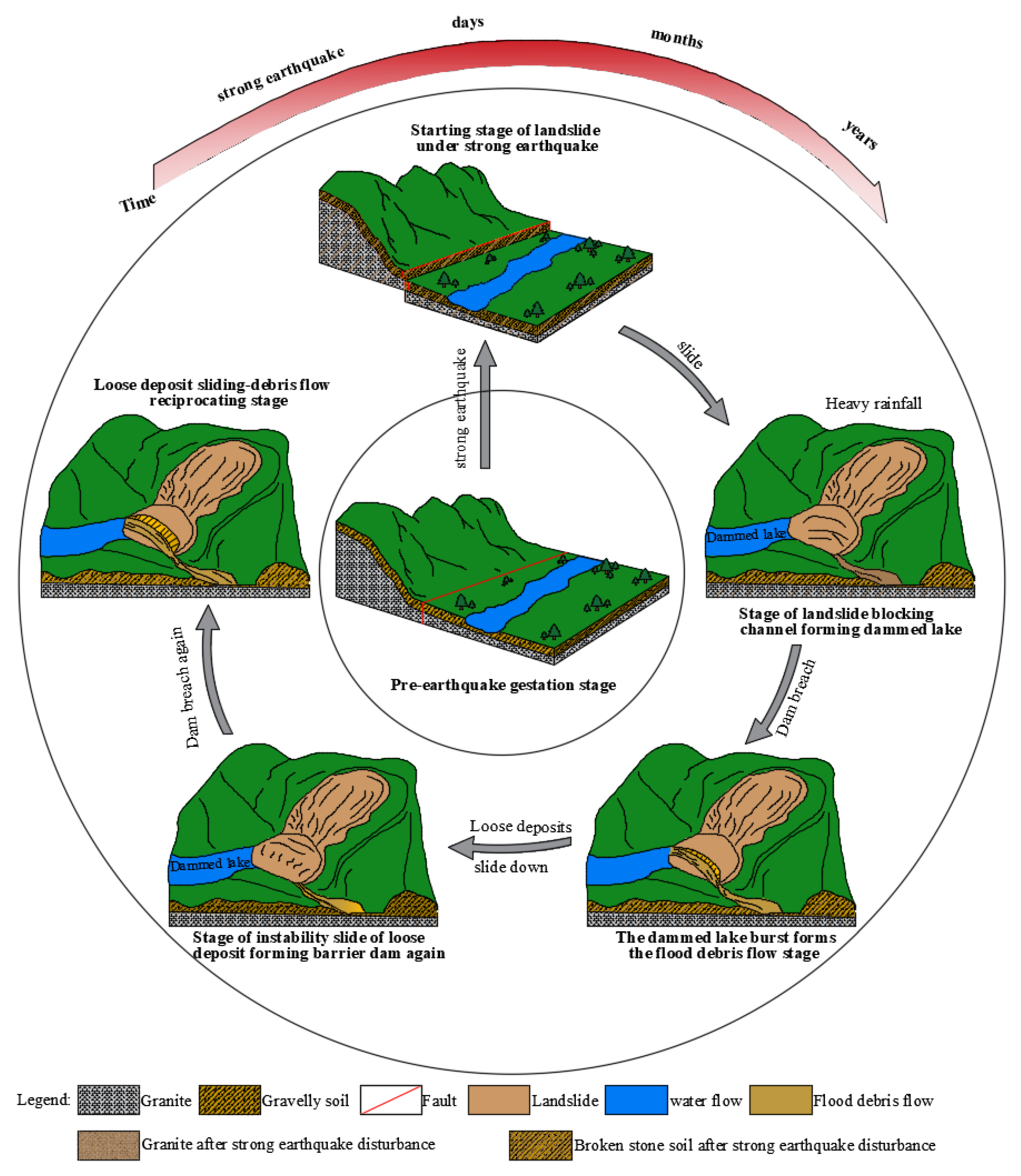
- Evolution process of the landslide–debris-flow geohazard chain
- (1)
- Pre-earthquake gestation: The Longmen Mountain fault zone had historically never recorded an earthquake with magnitude greater than 7. There had been a relatively long period of safety in this area before the “5.12” earthquake, and some energy had accumulated near the fault zone [56].
- (2)
- Starting of a landslide under strong earthquake: The landslide area is located in the hanging wall of the Longmen Mountain fault zone. In the event of a strong earthquake, the hanging wall is squeezed and lifted strongly, the potential energy increases, and the slope begins to slide easily. When a strong earthquake occurred, the accumulated sliding in the study area reached 230.51 m, far exceeding the critical sliding in the Longmen Mountain earthquake area. The slope in the study area could not be restored to its original state when the strong earthquake stopped, and the slope lost stability and formed a landslide.
- (3)
- Landslide blocking the channel and forming a dammed lake: As a result of the strong earthquake, the landslide accelerated downward after starting into motion, and maintained a high-speed sliding state before reaching the bottom of the gully. It collided with the slope on the other bank when it reached the bottom of the gully, resulting in the disintegration of the sliding body and the formation of a debris flow. With the increase in water level at the upstream end of the dam, a dammed lake was formed, as the debris flow blocked the channel, forming a temporary barrier dam.
- (4)
- Bursting of the dammed lake to form the flood debris flow: After the dammed lake was formed, due to its obstruction and energy dissipation, a large number of debris flow solid sources were deposited in the dammed lake. The gravity of the fluid passing through the dammed dam was severely reduced and the fluid rushed out of the groove at the front edge of the dammed body. As a result of the discharge of water, loose deposits were then washed downstream to form a larger-scale debris flow.
- (5)
- Unstable sliding of loose deposits: When the debris flow moved downstream, the front edge of loose deposit body was cut and eroded to form a narrow deep groove, and the front edge of landslide accumulation developed near the empty surface. As a result of erosion and undercutting caused by water flow or debris flow, the front edge of the landslide mass near the trench side further collapsed and formed a barrier dam once again.
- (6)
- Loose deposit sliding–debris flow reciprocating stage: The front edge of the loose deposits slid down, forming a dam to induce a new flood-burst debris-flow. With the decrease in the material source of the gully bank slope, the solid material source of the debris flow silted up, the bank slope gradient gradually decreased, and the development of the debris flow gradually declined until it stopped.
6. Conclusions
- (1)
- The Niumian Gully landslide–debris-flow geohazard chain was formed by strong earthquakes and rainfalls. As a result of the earthquakes, rock mass breakages, collapses, and landslides were triggered in the earthquake research area, providing abundant material sources for debris flows. The earthquakes also resulted in a significant reduction in the critical level of rainfall required for debris flow initiation in the research area. In the event of heavy rainfall, loose deposits are easily triggered, leading to catastrophic debris flows.
- (2)
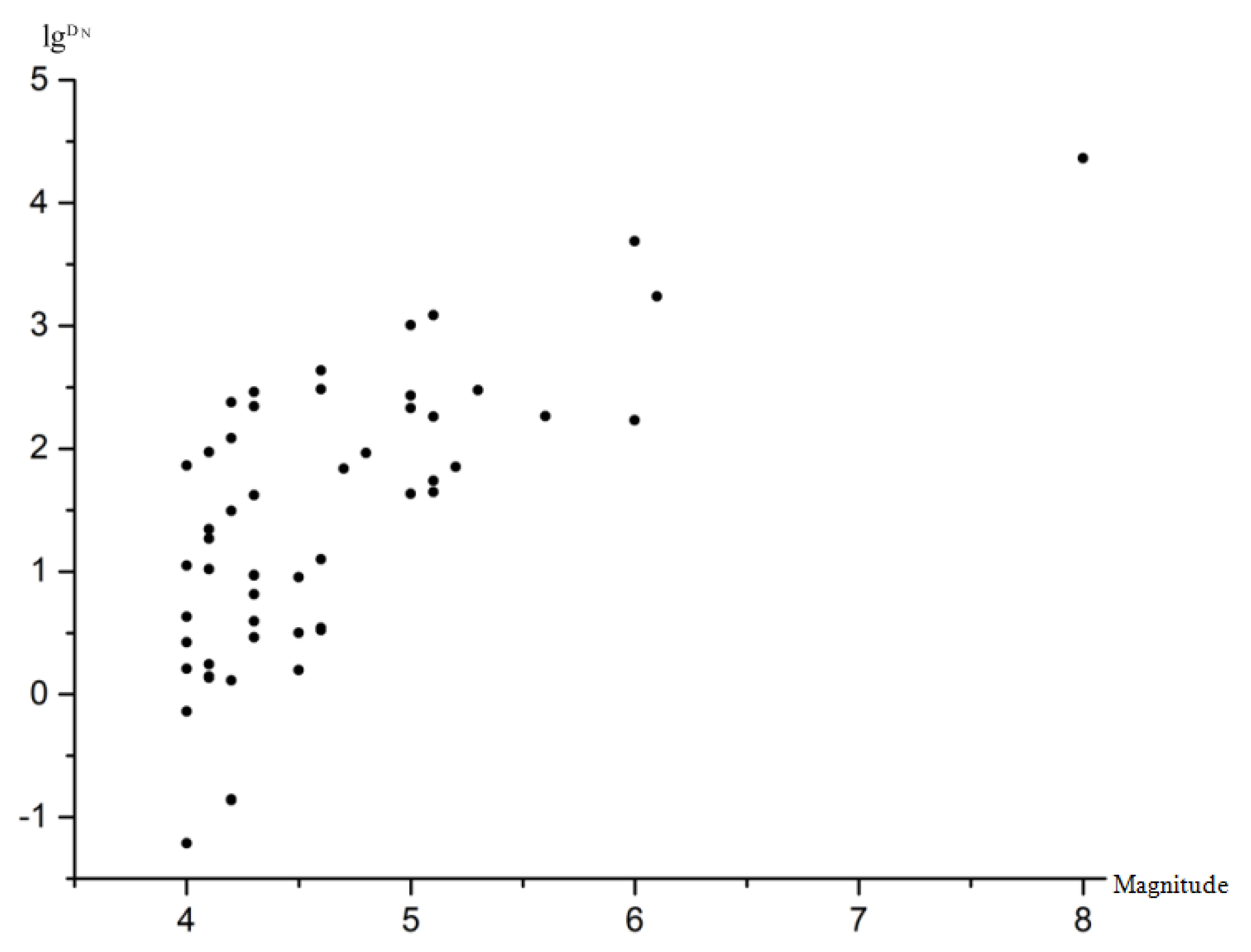
- In Wenchuan County, 145 earthquakes have been recorded, of which the Wenchuan Ms 8.0 earthquake had the greatest impact on the study area. Due to the earthquake, the accumulative sliding of the slope reached 230.51 m—far exceeding the critical sliding—and the slope was permanently damaged, resulting in a landslide.
- (3)
- Before the Wenchuan earthquake in 2008, Niumian Gully was a clear water gully. Unfavorable geological phenomena such as collapse and landslides in the basin were not obvious, and only a small volume of loose deposits was observed in the gully, with a total amount of approximately 93.97 × 10⁴ m3. After the earthquake, Niumian Gully was transformed into a high-frequency debris-flow gully. Adverse geological disasters such as collapses and landslides in the study area affected by the earthquake subsequently strongly developed, with the material source amount caused by collapse and landslide having been estimated as approximately 695.22 × 10⁴ m3, providing abundant loose solid materials for the occurrence of debris flows.
- (4)
- The characteristics of the Niumian Gully landslide–debris-flow geohazard chain are landslide instability–debris-flow, flood-burst debris-flow, and reciprocating debris flow models. Moreover, the Niumian Gully landslide–debris-flow geohazard chain development process can be summarized in the following stages: pre-earthquake gestation, starting of landslide under strong earthquake, landslide blocking channel and forming a dammed lake, burst dammed lake forming the flood-burst debris-flow, unstable sliding of loose deposits, and reciprocating loose deposit sliding–debris-flows. It is expected that the evolution of the geohazard chain will continue until the loose deposits on both banks are exhausted or the slope of the bank becomes less steep, at which point the loose deposits will no longer slide.
Author Contributions
Funding
Institutional Review Board Statement
Informed Consent Statement
Data Availability Statement
Conflicts of Interest
Appendix A. Rainfall-Induced Debris Flows
- (1)
- The critical rainfall model of gully-debris-flow-after-earthquake calculation formula is as follows:
| Parameter | Value |
|---|---|
| Catchment area A (km2) | 10.7 |
| Width of channel b (m) | 91.5 |
| Slope angle (°) | 25 |
| Sediment density (kg/m2) | 2050 |
| Water density (kg/m2) | 1000 |
| Thickness of loose deposits D (m) | 9 |
| Internal friction angle (°) | 28 |
| Cohesion (kPa) | 14 |
| Hydraulic conductivity coefficient T (m2/d) | 60 |
- (2)
- Critical rainfall model derived from frequency of debris flows and rainstorms
| Frequency Type | Standard of Classification | Scoring Standard |
|---|---|---|
| Extremely high frequency | A few to a dozen times a year | 6 |
| High frequency | Once or twice to several times a year | 5 |
| Sub-high frequency | Once every few years to once or twice a year | 4 |
| Intermediate frequency | Every ten years to every few years | 3 |
| Low frequency | Every few decades to every ten years | 2 |
| Extra low frequency | Once a hundred years to once every few decades | 1 |
| Rainfall | |||
|---|---|---|---|
| 1 h | Lower limit value /(mm/h) | ||
| Upper limit value /(mm/h) | |||
| 10 min | Lower limit value /(mm/10min) | ||
| Upper limit value /(mm/10min) | |||
| Rainfall | |||||||
|---|---|---|---|---|---|---|---|
| 5 | 0.085 | 0.106 | 7.5 | 20 | 1 h rainfall (mm/h) | I60min = 6.64 | I60min = 0 |
| I60max = 10.31 | I60max = 3 | ||||||
| 10 min rainfall (mm/h) | I10min = 2.49 | I10min = 0 | |||||
| I10max = 4.02 | I10max = 1.53 |
Appendix B
| Earthquake Magnitude(Ms) | Longitude | Latitude | The Distance to the Epicenter (km) | Earthquake Peak Acceleration (gal) |
|---|---|---|---|---|
| 4 | 31.2 | 103.1 | 37.1 | 2.452384928 |
| 4 | 31.3 | 103.4 | 29.4 | 3.55899096 |
| 4 | 31.27 | 103.39 | 25.87 | 4.341358061 |
| 4 | 30.86 | 103.31 | 23.52 | 5.018298566 |
| 4 | 30.86 | 103.37 | 21.17 | 5.871243119 |
| 4 | 30.9 | 103.4 | 16.4 | 8.464044712 |
| 4 | 31.1 | 103.4 | 8.29 | 19.9891648 |
| 4.1 | 31.27 | 103.6 | 29.53 | 4.142657647 |
| 4.1 | 31.3 | 103.4 | 29.4 | 4.171247106 |
| 4.1 | 30.9 | 103.2 | 28.23 | 4.442706854 |
| 4.1 | 31.2 | 103.5 | 18.63 | 8.23180998 |
| 4.1 | 31.1 | 103.3 | 15.68 | 10.45442023 |
| 4.1 | 31 | 103.3 | 14.78 | 11.31937306 |
| 4.1 | 31.1 | 103.5 | 8.35 | 22.74244336 |
| 4.2 | 31.34 | 103.16 | 42.82 | 2.676954895 |
| 4.2 | 31.4 | 103.6 | 42.77 | 2.682091032 |
| 4.2 | 31.3 | 103.6 | 32.91 | 4.088871065 |
| 4.2 | 31 | 103.3 | 14.63 | 13.26530827 |
| 4.2 | 31.1 | 103.5 | 8.35 | 26.00558706 |
| 4.2 | 31.1 | 103.5 | 8.35 | 26.00558706 |
| 4.2 | 31 | 103.4 | 5.91 | 36.88251656 |
| 4.3 | 31.28 | 103.61 | 31.26 | 5.171513335 |
| 4.3 | 31.3 | 103.5 | 29.33 | 5.704729417 |
| 4.3 | 30.95 | 103.19 | 25.99 | 6.849502941 |
| 4.3 | 31 | 103.2 | 23.71 | 7.846395917 |
| 4.3 | 31 | 103.2 | 23.67 | 7.86582914 |
| 4.3 | 31 | 103.3 | 14.68 | 15.2235601 |
| 4.3 | 31 | 103.5 | 7.02 | 35.42610896 |
| 4.3 | 31 | 103.4 | 6.04 | 40.91080745 |
| 4.5 | 31.4 | 103.3 | 42.59 | 4.303732606 |
| 4.5 | 31.3 | 103.2 | 37.35 | 5.302067856 |
| 4.5 | 31.3 | 103.2 | 37.35 | 5.302067856 |
| 4.5 | 31.3 | 103.4 | 29.24 | 7.724696882 |
| 4.6 | 31.4 | 103.5 | 40.57 | 5.401854879 |
| 4.6 | 31.4 | 103.5 | 40.24 | 5.472018972 |
| 4.6 | 31.3 | 103.4 | 29.38 | 8.867659771 |
| 4.6 | 31.1 | 103.5 | 8.54 | 42.14306413 |
| 4.6 | 31 | 103.5 | 7.02 | 50.94548044 |
| 4.7 | 31.2 | 103.5 | 18.53 | 19.43877454 |
| 4.8 | 31.2 | 103.4 | 18.3 | 22.5351409 |
| 5 | 31.3 | 103.5 | 29.38 | 15.412298 |
| 5 | 31.3 | 103.4 | 29.38 | 15.412298 |
| 5 | 30.9 | 103.4 | 15.75 | 34.87637656 |
| 5 | 31 | 103.3 | 14.15 | 39.51027124 |
| 5 | 31 | 103.5 | 6.81 | 81.17318134 |
| 5.1 | 31.3 | 103.3 | 31.82 | 15.68648968 |
| 5.1 | 31.3 | 103.5 | 29.65 | 17.34636402 |
| 5.1 | 31.2 | 103.5 | 18.66 | 32.0587289 |
| 5.1 | 31 | 103.5 | 6.81 | 89.85627985 |
| 5.2 | 31.3 | 103.5 | 29.65 | 19.72306798 |
| 5.3 | 31.2 | 103.4 | 18.27 | 41.65571443 |
| 5.6 | 31.3 | 103.4 | 29.49 | 32.25102228 |
| 6 | 31.4 | 103.6 | 42.37 | 30.98509765 |
| 6 | 31 | 103.5 | 6.81 | 194.8098796 |
| 6.1 | 30.9 | 103.4 | 15.75 | 109.4868574 |
| 8 | 31 | 103.4 | 6.04 | 469.1166735 |
References
- Chai, H.J.; Liu, H.C.; Zhang, Z.Y. The catalog of Chinese landslide dam events. J. Geol. Hazards Environ. Preserv. 1995, 6, 1–9. [Google Scholar]
- Yin, G.H.; Li, J.; Zhang, Y.; Yang, Z. Statistical analysis and research of landslides caused by Nileke. Inland Earthq. 2001, 15, 56–63. [Google Scholar]
- Wang, J.; Bai, M.; Xiao, S. A study on compound mechanism of earthquake-related sliding displacements on gently inclined loess slope. Chin. J. Geotech. Eng. 2001, 23, 445–449. [Google Scholar]
- He, N.; Fu, Q.X.; Zhong, W.; Yang, Z.Q.; Cai, X.Q.; Xu, L.J. Analysis of the formation mechanism of debris flows after earthquakes—A case study of the Legugou debris flow. Front. Ecol. Evol. 2022, 10, 1053687. [Google Scholar] [CrossRef]
- Li, Z.S. The state of the art of the research on seismic landslide hazard at home and abroad. J. Catastrophology 2003, 18, 64–70. [Google Scholar]
- Sun, C. Developing and distributing characteristics of collapses and landslides during strong historic earthquake in China. J. Nat. Disasters 1997, 6, 25–30. [Google Scholar]
- Cui, P.; Zhuang, J.Q.; Chen, X.C.; Zhang, J.Q.; Zhou, X.J. The characteristics of debris flow activities after the Wenchuan earthquake and the countermeasures. J. Sichuan Univ. Eng. Sci. Ed. 2010, 42, 10–19. [Google Scholar]
- Liang, Y.F.; Pei, X.J.; Cui, S.H.; Zhu, L.; Gao, H.H.; Dong, Y. Study on the chain effect of geological hazards in Huangdongzigou induced by Wenchuan earthquake and the measures to break the chain. Disaster Sci. 2018, 33, 9. [Google Scholar]
- Yang, X.Y. Study on the development background of geological hazards in Ludian. Yunnan People’s Yangtze River 2018, 49, 57–61. [Google Scholar]
- Wang, T.; Wang, J.K.; Pan, D. The formation mechanism of Kangjiapo landslide in Hanyuan, Sichuan, and the analysis of landslide dam debris flow disaster chain. Chin. J. Geol. Hazards Prev. 2020, 31, 1–7. [Google Scholar]
- Zhong, Y.; Bian, S.Q.; Yang, Y.P.; Jin, J.C.; Huang, F.C.; Chen, G. Disaster model and risk assessment of landslide debris flow disaster chain in mountain and gorge area—Taking Zhouqu Lijiajie as an example. J. Lanzhou Univ. Nat. Sci. Ed. 2022, 58, 372–384. [Google Scholar]
- He, S.; Li, D.; Luo, W.Y. Study on the rainfall and aftershock threshold for debris flow of post-earthquake. J. Mt. Sci. 2011, 8, 750–756. [Google Scholar] [CrossRef]
- Shou, K.J.; Hong, C.Y.; Wu, C.C. Spatial and temporal analysis of landslides in Central Taiwan after 1999 Chi-Chi earthquake. Eng. Geol. 2011, 123, 122–128. [Google Scholar] [CrossRef]
- Lin, C.W.; Liu, S.H.; Lee, S.Y. Impacts of the Chi-Chi earthquake on subsequent rainfall-induced landslides in central Taiwan. Eng. Geol. 2006, 86, 87–101. [Google Scholar] [CrossRef]
- Guo, X.; Cui, P.; Li, Y. Intensity–duration threshold of rainfall-triggered debris flows in the Wenchuan earthquake affected area, China. Geomorphology 2016, 253, 208–216. [Google Scholar] [CrossRef]
- Qiao, J.P.; Huang, D.; Yang, Z.J.; Meng, H.J. Discussion on macro epicenter of Wenchuan Earthquake Disaster. Science 2013, 28, 1–5. [Google Scholar]
- Li, N.; Tang, C.; Bu, X.H.; Li, H.B. Analysis on the characteristics and evolution of debris flow in Wenchuan County after the “5.12” earthquake. J. Eng. Geol. 2020, 28, 1233–1245. [Google Scholar]
- Yu, B.; Xie, H.; Wang, S.G.; Zhang, S.C.; Lu, K.; Han, L. The active trend of debris flow gully in Wenchuan County after the “5.12” Wenchuan earthquake. J. Nat. Disasters 2011, 20, 68–73. [Google Scholar]
- Tang, C.; Chang, M. Catastrophic debris flows on 13 August 2010 in the Qingping area, southwestern China: The combined effects of a strong earthquake and subsequent rainstorms. Geomorphology 2012, 139, 559–576. [Google Scholar] [CrossRef]
- Gao, H.H.; Pei, X.J.; Cui, S.H.; Zhu, L.; Liang, Y.F. Statistical analysis on the development, distribution and evolution characteristics of geological disasters after the Wenchuan earthquake. J. Yangtze River Acad. Sci. 2019, 36, 73. [Google Scholar]
- Lan, J.; Chen, X.L. Evolution characteristics of landslide disaster induced by 2008 Ms8.0 Wenchuan earthquake in Yingxiu area. Seismogeology 2020, 42, 125–146. [Google Scholar]
- Huang, R.Q. Post effect analysis of Wenchuan earthquake geological disasters. J. Eng. Geol. 2011, 19, 145–151. [Google Scholar]
- Cui, S.H.; Pei, X.J.; Wang, G.H. Based on the ring shear test, explored the initiation mechanism of large-scale landslides in the Wenchuan earthquake. J. Geotech. Eng. 2017, 39, 2268–2277. [Google Scholar]
- Yang, Z.; Zhao, X.; Chen, M.; Zhang, J.; Yang, Y.; Chen, W.; Bai, X.; Wang, M.; Wu, Q. Characteristics, Dynamic Analyses and Hazard Assessment of Debris Flows in Niumiangou Valley of Wenchuan County. Appl. Sci. 2023, 13, 1161. [Google Scholar] [CrossRef]
- Yang, Q.; Fan, X.M.; Xu, Q.; Dai Lan, X.; Ren, J. Research on the deformation history and formation mechanism of Tangjiawan landslide in Beichuan. Hydrogeol. Eng. Geol. 2018, 45, 6–15. [Google Scholar]
- Tang, C.; Zhu, J.; Qi, X.; Ding, J. Landslides induced by the Wenchuan earthquake and the subsequent strong rainfall event: A case study in the Beichuan area of China. Eng. Geol. 2011, 122, 22–33. [Google Scholar] [CrossRef]
- Lu, Y.X.; Wei, L.; Liu, K.; Li, T.L.; Zheng, H.Z.; Wang, C.Y.; Yang, B. Study on the site effect of ground motion in the landslide concentrated area of the 1920 Haiyuan earthquake. J. Seism. Eng. 2020, 42, 1151–1158. [Google Scholar]
- Zhu, Y.X.; Dai, F.C.; Yao, X.; Tu, X.B.; Shi, X.S. Field investigation and numerical simulation of the seismic triggering mechanism of the Tahman landslide in eastern Pamir, Northwest China. Bull. Eng. Geol. Environ. 2019, 78, 5795–5809. [Google Scholar] [CrossRef]
- Ghorbanzadeh, O.; Xu, Y.; Zhao, H.; Wang, J.; Zhong, Y.; Zhao, D.; Zang, Q.; Wang, S.; Zhang, F.; Shi, Y.; et al. The Outcome of the 2022 Landslide4Sense Competition: Advanced Landslide Detection From Multisource Satellite Imagery. IEEE J. Sel. Top. Appl. Earth Obs. Remote Sens. 2022, 15, 9927–9942. [Google Scholar] [CrossRef]
- Fan, X.; Scaringi, G.; Korup, O. Earthquake-induced chains of geologic hazards: Patterns, mechanisms, and impacts. Rev. Geophys. 2019, 57, 421–503. [Google Scholar] [CrossRef] [Green Version]
- Zhou, X.; Cui, P.; Li, Z. Development and application of integrated test equipment for permeability and settlement of gravelly soil in triggering area of debris flow. Chin. J. Rock Mech. Eng. 2012, 31, 1281–1289. [Google Scholar]
- Qing, F.; Meng, X.M.; Guo, F.Y.; Zhao, Y. Analysis of the characteristics of the “August 7” debris flow disaster in Wenxian County, the Wenchuan earthquake disturbed area—Taking Yangtang Valley as an example. J. Lanzhou Univ. Nat. Sci. Ed. 2021, 57, 6. [Google Scholar]
- Tang, C.; Zhu, J.; Li, W.L.; Liang, J.T. Rainfall-triggered debris flows following the Wenchuan earthquake. Bull. Eng. Geol. Environ. 2009, 68, 187–194. [Google Scholar] [CrossRef]
- Huang, X.; Tang, C. Quantitative analysis of dynamic characteristics of erosion collapse debris flow in strong earthquake area. J. Eng. Geol. 2017, 25, 1491–1500. [Google Scholar]
- Wang, Y.S.; Zhao, B.; Li, J. Mechanism of the catastrophic June 2017 landslide at Xinmo Village, Songping River, Sichuan Province, China. Landslides 2018, 15, 333–345. [Google Scholar] [CrossRef]
- Huang, R.Q.; Xu, Q. Preliminary study on dynamic characteristics of large landslide disaster induced by 5.12 Wenchuan earthquake. J. Eng. Geol. 2008, 16, 721–729. [Google Scholar]
- Li, F.; Li, S.M.; Yang, Y.; Li, J.; Yuan, L.W.; Cheng, R.; Mao, J. Study on Development Characteristics of Shawan Dagou Landslide Debris Flow Based on Time Series In SAR. Adv. Geophys. 2023, 3, 1–11. [Google Scholar]
- Wang, J.; Cui, Y.; Choi, C.E. The Effect of Climate Change on Alpine Mountain Hazards Chain: A Case Study in Tianmo Ravine, Tibet, China. In Proceedings of the 8th International Congress on Environmental Geotechnics, Hangzhou, China, 28 October–1 November 2018; Volume 3, pp. 461–470. [Google Scholar]
- Zhuang, J.Q.; Cui, P.; Ge, Y.G. Risk Assessment of Debris Flow Gullies along Duwen Highway after—“5.12” Earthquake AU Zhuang, Jianqi. J. Sichuan Univ. Eng. Sci. Ed. 2009, 3, 131–139. [Google Scholar]
- Pan, J.; Li, H.; Si, J.; Pei, J.; Fu, X.; Chevalier, M.L.; Liu, D. Rupture process of the Wenchuan earthquake (Mw 7.9) from surface ruptures and fault striations characteristics. Tectonophysics 2014, 619, 13–28. [Google Scholar] [CrossRef]
- Li, Y.; Zhou, R.J.; Yan, L. Surface Fracture and Deformation Characteristics of Yingxiu Beichuan Fault. J. Geol. 2008, 82, 1688–1706. [Google Scholar]
- Yang, Z.Q.; Liao, L.P.; Yang, W.K. Discussion on Formation Conditions, Development Trend and Prevention of Debris Flow in Niumian Valley. Geod. Geodyn. 2011, 31, 71–74. [Google Scholar]
- Data Sharing Infrastructure of National Earthquake Data Center. Available online: http://data.earthquake.cn (accessed on 16 March 2023).
- Cao, Z.; Wang, Y.; Zhang, H.; Liu, Y.; Liu, S.; Yin, L.; Zheng, W. Study on spatio-temporal characteristics of earthquakes in southwest China based on z-value. Open Geosci. 2022, 14, 185–207. [Google Scholar] [CrossRef]
- Liu, J.M.; Wang, T.; Shi, J.S.; Li, Z.T. Sichuan Jiuzhaigou Ms7.0 earthquake landslide emergency quick assessment. J. Geomech. 2017, 23, 639–645. [Google Scholar]
- Wang, X.Y.; Nie, G.Z. Preliminary analysis on the characteristics of landslide induced by Ms8.0 Wenchuan earthquake and its corresponding relationship with ground motion parameters. J. Geotech. Eng. 2009, 31, 1378–1383. [Google Scholar]
- Wang, X.Y.; Nie, G.Z.; Wang, D.W. Analysis of Wenchuan earthquake induced landslides using strong earthquake records. J. Rock Mech. Eng. 2009, 28, 2369–2376. [Google Scholar]
- Wang, X.Y. Research on rapid assessment technology of earthquake landslide disaster and its impact on emergency response International Earthquake. Dynamics 2010, 29, 2159. [Google Scholar]
- Yu, Y.X.; Wang, S.Y. Attenuation relationship between peak horizontal bedrock acceleration and response spectrum in the northeastern Qinghai Tibet Plateau. J. Seismol. 2004, 26, 591–600. [Google Scholar]
- Xu, G.X.; Yao, L.K.; Li, C.H.; Wang, X.F. Slope permanent displacement prediction model based on strong motion records of Wenchuan earthquake. J. Geotech. Eng. 2012, 34, 1131–1136. [Google Scholar]
- Wang, M.; Wang, J.; Wang, Y.M.; Wang, X.G.; Jiang, Y. Analysis of remote sensing dynamic change characteristics of debris flow in Niujuan gully in Wenchuan earthquake area. China Environ. Remote Sens. Appl. Technol. Forum 2014, 11, 286–296. [Google Scholar]
- Huang, R.Q.; Li, W.L. Study on the development and distribution of geological disasters triggered by the “5.12” Wenchuan earthquake. J. Rock Mech. Eng. 2008, 27, 2585–2592. [Google Scholar]
- Wilson, R. Predicting areal limit of earthquake-induced landsliding, evaluating earthquake hazards in the Los Angeles region-an earth-science perspective. US Geol. Surv. Prof. Pap. 1985, 1360, 317–345. [Google Scholar]
- Wang, X.Y.; Nie, G.Z.; Wang, S. Evaluation criteria for ground motion acceleration of landslides induced by Wenchuan earthquake. J. Seismol. 2011, 33, 82–90. [Google Scholar]
- Yao, L.K. Discussion on the estimation of critical rainfall from the frequency of debris flow and rainstorm. J. Soil Water Conserv. 1988, 2, 72–77. [Google Scholar]
- Li, H.B.; Xu, Z.Q.; Wang, H. Wenchuan earthquake main slip zone (psz): Oblique thrust fault in Yingxiu Beichuan fault zone. Geol. China 2013, 40, 121–139. [Google Scholar]




| Landslide | Source Type | Length (m) | Width (m) | Thickness (m) | Source Volume (104 m3) |
|---|---|---|---|---|---|
| Landslide H01 | Residual accumulation | 270 | 120 | 5 | 16.2 |
| Lower accumulation | 210 | 54 | 9 | 10.2 | |
| Landslide H02 | Residual accumulation | 380 | 250 | 17 | 161.5 |
| Landslide–debris-flow accumulation | 800 | 15 | 10 | 12.0 | |
| Landslide–debris-flow accumulation | 1020 | 90 | 28 | 257.0 | |
| Landslide H03 | Landslide–debris-flow accumulation | 147 | 100 | 24 | 35.3 |
Disclaimer/Publisher’s Note: The statements, opinions and data contained in all publications are solely those of the individual author(s) and contributor(s) and not of MDPI and/or the editor(s). MDPI and/or the editor(s) disclaim responsibility for any injury to people or property resulting from any ideas, methods, instructions or products referred to in the content. |
© 2023 by the authors. Licensee MDPI, Basel, Switzerland. This article is an open access article distributed under the terms and conditions of the Creative Commons Attribution (CC BY) license (https://creativecommons.org/licenses/by/4.0/).
Share and Cite
He, N.; Qu, X.; Yang, Z.; Xu, L.; Gurkalo, F. Disaster Mechanism and Evolution Characteristics of Landslide–Debris-Flow Geohazard Chain Due to Strong Earthquake—A Case Study of Niumian Gully. Water 2023, 15, 1218. https://doi.org/10.3390/w15061218
He N, Qu X, Yang Z, Xu L, Gurkalo F. Disaster Mechanism and Evolution Characteristics of Landslide–Debris-Flow Geohazard Chain Due to Strong Earthquake—A Case Study of Niumian Gully. Water. 2023; 15(6):1218. https://doi.org/10.3390/w15061218
Chicago/Turabian StyleHe, Na, Xiangyang Qu, Zhiquan Yang, Linjuan Xu, and Filip Gurkalo. 2023. "Disaster Mechanism and Evolution Characteristics of Landslide–Debris-Flow Geohazard Chain Due to Strong Earthquake—A Case Study of Niumian Gully" Water 15, no. 6: 1218. https://doi.org/10.3390/w15061218
APA StyleHe, N., Qu, X., Yang, Z., Xu, L., & Gurkalo, F. (2023). Disaster Mechanism and Evolution Characteristics of Landslide–Debris-Flow Geohazard Chain Due to Strong Earthquake—A Case Study of Niumian Gully. Water, 15(6), 1218. https://doi.org/10.3390/w15061218


