Article

Repeatability of Hydroacoustic Results versus Uncertainty in Assessing Changes in Ecological Status Based on Fish: A Case Study of Lake Widryńskie (Poland)

by
Andrej Hutorowicz
Hydroacoustic Laboratory, National Inland Fisheries Research Institute, Oczapowskiego 10, 10-719 Olsztyn, Poland
Water 2024, 16(10), 1368; https://doi.org/10.3390/w16101368
Submission received: 9 April 2024 / Revised: 6 May 2024 / Accepted: 8 May 2024 / Published: 11 May 2024

Abstract

:
Assessments of changes in the ecological state of aquatic ecosystems are always burdened with uncertainty, which results from environmental reasons and poor repeatability of measurement results of elements enabling the assessment. This study determines the uncertainty related to the elements of the assessment of the hydroacoustic structure of fish communities’ (1) vertical target strength distribution (TS) in two-meter layers of water and (2) changes in the area where fish were recorded (which was determined on the basis of maps of their distribution in 2 m deep water layers). The object of this study was a lake (depth: 27 m) in which at the end of June 2016 the O2 concentration was <1.4 mg L−1 below 8 m depth, which resulted in the accumulation of fish to a depth of 6 m. Hydroacoustic acquisition was carried out along transects arranged in the east–west (WE), north–south (NS), and zigzag (ZZ) directions in three repetitions. It was shown that the empirical probability of obtaining statistically different results was 2/9 when (1) Kendall’s τ coefficient, used to determine the similarity of the TS distribution, was less than 0.7—moderate correlation—and (2) fish occurrence areas in two cases (WE and ZZ on the third day of research) in layers 2–4 m and 4–6 m differed statistically significantly from the average area for all repetitions by 10–14% and 56–66% (p < 0.05), respectively. The obtained results indicate quite good repeatability of acoustic measurements; however, in order to reduce the uncertainty, it is recommended that tests be conducted in this type of lake in three series of measurements.

1. Introduction

With the introduction of the obligation to assess ecological quality under the Water Framework Directive (EU-WFD, 2000), a problem arose of the proper integration of partial assessments and the uncertainty of the final assessment of the ecological status of water bodies [1,2]. Findings based on repeated measurements over historical time frames have often been questioned due to the limited spatial and temporal frequency of data and the spatial and temporal heterogeneity of biological communities [3,4]. Studies have appeared in the literature testing various integration scenarios, which include, among others, high uncertainty (large standard deviation) associated with one biological element and its impact on the risk of misclassification [1]. In parallel, research has been undertaken to estimate the error resulting from the variability in the results obtained by different researchers conducting repeated studies of the same transect or the same sample, etc. [5,6]. New measures for estimating uncertainty in the scope of groups of water indicators and groups of water quality indicators have been proposed, followed by an assessment of ecological status related to the hierarchy of classification procedures and an analysis of the frequency of occurrence of uncertainty intervals in the assessment of ecological status [7].
Previous research has drawn attention to measurement uncertainty as an inherent element of the assessment of biological indicators of water bodies.
The occurrence of random errors in the measurements of biological indicators of water ecological status assessment was simulated using Monte Carlo models. The long data series obtained in this way were used to identify values that did not fall within the range of the “true” class. They were used to estimate the probability of misclassification [8]. Another study analyzed the impact on the classification of the ecological status of lakes by changing the frequency of phytoplankton sampling and omitting some of the three indicators (calculated from chlorophyll a concentration, total phytoplankton biomass, and total cyanobacteria biomass) from the Phytoplankton Multimetric for Polish Lakes (PMPL index) [9].
Hydroacoustic methods, developed for several decades, are now considered reliable and are routinely used in scientific research and the monitoring of aquatic ecosystems [10]. The European Committee for Standardization, on the basis of the Water Framework Directive, has adopted a standard for sampling and procedures for “fish population abundance estimates of pelagic and profundal waters > 15 m mean depth with the acoustic beam oriented vertically, and the inshore and surface waters of water bodies > 2 m depth with the beam oriented horizontally” [11]. Previous studies have shown that differences in the density or biomass of fish assessed at different frequencies (38, 70, 120, and 200 kHz) are usually so small (and statistically significant) that they can be considered insignificant in fish population management [10]. However, with typical eutrophic ecosystems, fish densities (>600 fish ha−1) in temperate lakes may be significantly lower for 200 kHz systems [12]. Moreover, at night fish usually disperse in the water column, which allows the detection of a single echo and accurate estimation of fish size [13,14]. The differences between the pelagic fish biomass assessed by the hydroacoustic method during the day and at night may be even more than five times higher (e.g., 62 and 11 kg/ha in Lake Sauka in Latvia) [15]. Hydroacoustic data also show that smaller fish can gather at shallower depths [13]. Clear seasonal differences in habitat use by different fish species have also been observed [16] and population estimates in spring may even be several times higher than ones in summer (e.g., 4.0–8.5 larger in Crystal Lake in Vilas County, Wisconsin) [17]. However, many studies have concluded that hydroacoustic techniques can be successfully used to quantify the density and size distribution of fish [18].
The method of analyzing acoustic data proposed in a previous study [19], which may enable the detection of significant changes in the structure of ichthyofauna in lakes and on this basis a change in the ecological state, requires determining the uncertainty of the results. An attempt to determine such uncertainty based on the results collected in Lake Widryńskie was the aim of this study.

2. Materials and Methods

The analyses were carried out on the basis of data collected on 21/22, 22/23, and 27/28 June 2016 in the dimictic Lake Widryńskie (Figure 1). This lake is located in north-eastern Poland in the area of the Great Masurian Lake District (latitude: 54.0383°; longitude: 21.6067°). The total area of the lake is 1.239 km2, the volume is 10.6 × 10⁶ m3, the average depth is 8.5 m, and the maximum depth is 27.0 m. No systematic monitoring studies have been conducted in Lake Widryńskie. Only in 2000, as part of the State Environmental Monitoring, was the state of water purity assessed on a three-point scale based on physicochemical and several biological indicators. The water of this reservoir was classified as having class II purity [20].
Hydroacoustic methods, which are often used to assess fish numbers, require an appropriate density of the measurement network. Aglen [21] defined the cover factor as the ratio of the length of all transects to the square root of the lake area. In order to determine the minimum value of the coverage coefficient in a given lake, which ensures relative stability of the estimated values of fish numbers and their distribution, comparisons of changes in these parameters were carried out while reducing the number of transects [22]. In order to reduce the risk of error, research was also carried out in (three) repetitions according to the same survey routes [23].
Field measurements were conducted from 21:57 to 01:34 using a Simrad EY500 with a 120 kHz frequency echosounder (Simrad A Konsberg Company, Bergen, Norway), which worked with a 4 × 10° elliptical transducer pointing vertically downward. The transducer was mounted on a special position-stabilizing frame. Since the short duration (“length”) of the pulse ensures very good vertical resolution [24], during these tests, the pulses were 0.3 ms long and were sent at the maximum frequency. Hydroacoustic research was carried out at a speed of 8 km h−1 every night (on 21/22 June; 22/23 June; and 27/28 June 2016) along three types of transects (Figure 1):
-
Transects running in the east–west direction (marked with the abbreviation WE in the text);
-
Zigzag transects (ZZ);
-
Transects running in the north–south direction (NS).
The total length of the transects, which covered the entire surface of the lake (Figure 1), ranged from 7.6 km (ZZ) to 9.3 km (NS). Therefore, the so-called degree of coverage (Λ), defined by Aglen [21] as the ratio of the total length of acoustically tested transects (in km) to the square root of the lake surface (in km2), ranged from 7.6 to 9.2. Since the degree of cover should be at least 3.0 and preferably around or above 6.0 [25], the coefficient of variation of estimated fish abundance could be expected to be much less than 10% [26].
On 22 June, the concentration of dissolved oxygen in water and the temperature in the vertical profile were measured. Measurements were taken using a YSI 5740 Dissolved Oxygen and Temperature probe (Yellow Springs Instruments Co., Inc., Yellow Springs, OH, USA).
Hydroacoustic data were processed according to the scheme proposed in a paper describing changes in Lake Dejguny [19]. The data were processed using the Simrad EP500 system ver. 5.3 for post-processing the echo data produced by the Simrad EY 500 (the condition adopted in the scheme; data analysis was appropriate for the type of echo sounder). Signals in the range of −50 dB to −17 dB in TS intervals of 3 dB width were analyzed. This range was adopted, in this analysis scheme, because of the low effectiveness of gill nets in fishing for small fish [27]. Gill nets do not effectively catch roach (Rutilus rutilus L.), perch (Perca fluviatilis L.), and rudd (Scardinius erythrophtalmus L.) less than 40–50 mm in length [27,28]. The single-fish echoes were evaluated in water layers 2 m deep from the surface to the bottom of the lake. The number of fish (n) with a specific target strength (TS) was used to construct diagrams depicting the distribution of the target strength across the lake and the distribution of the TS in the water column. The consistency of the changes in the target strength (TS) distributions with depth in the 9 compared replicates (3 transect types on 3 consecutive test days) was evaluated using Kendall’s tau correlation coefficient (τ). This coefficient expresses the correlation of traits measured on an ordinal scale [29] and assesses the similarity of the arrangement of objects in data sets from two periods r and s. The reference distribution (s) was the distribution of mean n values for each TS interval. The calculations were performed in R version 3.6.3 using the moments package. During interpretation, the convention proposed by Guilford [30] was used (Table 1).
Re-analysis of echograms in sections of 100 pings, i.e., about 30 m long, allowed data to be obtained for mapping the spread of fish in selected layers (with the largest number of single-fish echoes). Visualization of XYZ data (where XY specifies the location of the point in a rectangular coordinate system and Z specifies the n fish detected) was performed through mapping in Surfer. A regular grid of values was created using the kriging method with a linear variogram. Based on this, maps were generated in which isolines surrounded areas with a given number n of detected echoes of individual fish, i.e., for n = 1, n = 5, n = 10, and n = 15 to n = 20. The data also included XY coordinates depicting the coastline. Fish echo areas (n ≥ 1) were determined in Surfer. In order to determine the spread of distributions describing the size of areas designated separately for n ≥ 1, 5, and 10 single-fish echoes, the coefficient of variation (CV) was used, which is defined as the ratio of the standard deviation σ to the average value x ¯ :
C V = δ x ¯   100 %   ,
and
δ = x x ¯ 2   f N 1
It was assumed that CV = 5% is small, above 10% is quite large, and above 30% is very large [31].
Boxplots were used to identify potential outliers (xo), where any observation x that satisfied the pattern of inequalities was as follows:
x o > q 0.75 + 1.5 I Q R or x o < q 0.25 1.5 I Q R
where q0.25 means the first quartile; q0.75 represents the third quartile; and IQR is the difference between the third and first quartiles.
Next, it was checked whether each potential outlier (xo) differed significantly from the set of other measurements that met the IQR criterion. The difference (D) between the mean of this population (μ1) and those of individual potential outliers (xo) is as follows:
D = μ 1 x o   or   D = x o μ 1
The average error of this difference (ΕD) was determined:
E D = δ 1 N 1 + 1 N 1
where δ1 is the standard deviation of random variable x 1 and N 1 is the sum of frequencies.
The probability of the difference (D) between the mean of this population (μ1) and those of individual potential outliers (xo) was estimated based on Student’s t-test for degrees of freedom n = N1 − 1.
Based on the essence of the large fish indicator, the IND index was calculated [19]. According to the idea of the large fish indicator [32], the IND value is simply the ratio of the sum of the number of fish with a total length greater than the assumed threshold that defines “large fish” (TLLarge) to the number of all fish (larger than TLAll). In a previous study, which described this method using the example of data from Lake Dejguny, the limits for TLLarge were ≥30 cm and for TLAll they were ≥10 cm [33]. As indicated by Hutorowicz et al. [19], the equation that best described the relationship between target strength (TS) and total fish length (LC) indicated that the corresponding target strength values were −38 dB and −47 dB, respectively. The index was determined according to the following equation (in a previous study [19], other TS ranges were mistakenly provided):
I N D = 38   d B 29   d B n T S   / 47   d B 29   d B n T S
where nTS is the number of fish with a specific target strength (TS). According to this assumption, the comparison of IND values at the beginning and at the end of a given period should allow for an effective and successful assessment of changes in ecological status [19].

3. Results and Discussion

The number of single-fish echoes identified in individual studies ranged from 1417 to 3356 (Figure 2a). The variability in these results was very high; the coefficient of variation (CV) = 110%, but all values met the IQR criterion (on the boxplot chart, even the most extreme values were not marked as potential outliers (Figure 2b)). Student’s t-test did not confirm the existence of a statistically significant difference (p = 0.111) between the number of single-fish echoes recorded on zigzag transects (ZZ) and the number of fish echoes recorded on the remaining transects (WE and NS).
The skewness of the mean echo number distribution was 0.36, which indicated weak positive asymmetry (Figure 3). In all nine replicates, the peak echo number of individual fish was recorded in the range of –47 < TS < –44 dB. The share of fish with TS > −38 dB, i.e., the largest fish that are the target of fishermen, was very small and ranged within very narrow limits from 1% to 2%. It was therefore several times (4–8 times) smaller than the one recorded in 2021 in Lake Dejguny and over 12 times smaller than the one recorded in 2008 [19].
The TS distribution of single-fish echoes (average value from nine repetitions) in water layers at depths from 0 to 24 m (Figure 4a) was the result of changes in the concentration of oxygen dissolved in water (Figure 4b). Fish were concentrated in the upper layers of water (up to 8 m deep). The greatest number of fish (i.e., 62% of all detected) was recorded in the layer from 2 to 4 m and 36% of echoes were recorded at a depth of 4–6 m. In the remaining layers, there was a maximum of less than 5% (0–2 m), but with less than 8 m depth, with an oxygen concentration less than 1.4 mg L−1 (Figure 4b), and this accounted for only about 0.1%.
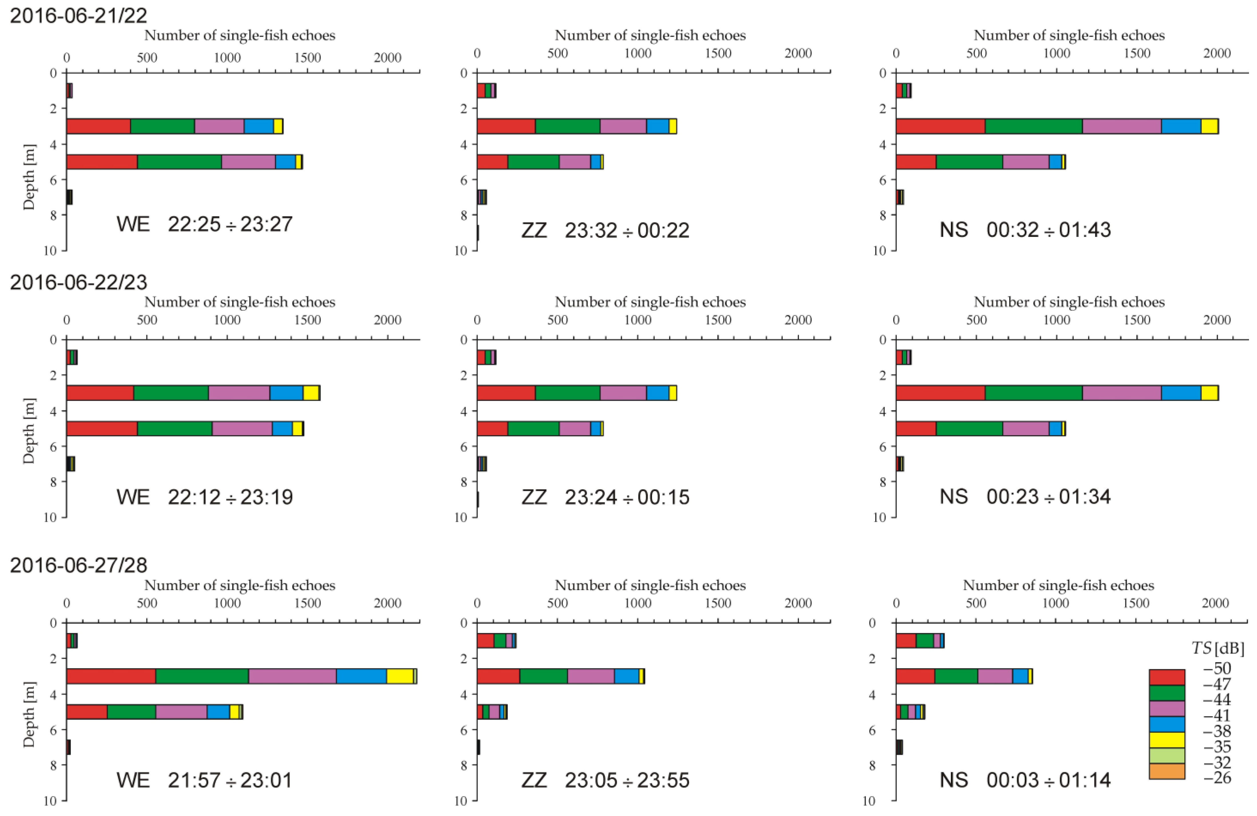
The variation in the TS distribution of single-fish echoes in profiles within individual types (WE, NS, and ZZ) from the nights of 21/22 and 22/23 June was relatively small (Figure 5). However, in this case, in the WE profile from 21/22 June, the maximum number of fish was surprisingly recorded in the 4–6 m layer, and not 2–4 m as in other profiles. However, greater differences occurred between individual types of transects. The number of fish in layer 4–6 in the ZZ and NS transects was 0.45 to 0.65 of the number of fish in the 2–4 m layer, while in the WE profiles it was 0.93 to 1.08. The greatest number of fish is usually recorded in the 2–4 m layer, but on the night of 21/22 June in the WE transects the greatest number of fish was recorded between a depth of 4 and 6 m (Figure 5). Very large differences were observed as a result of research conducted on the night of 27/28 June. Along the WE transects, the highest number of fish and the maximum number of fish in the 2–4 m layer and the maximum number of fish with TS in the range of −38 dB to −35 dB were recorded. However, later (between 11:05 p.m. and 01:14 a.m.) the maximum number of fish was found in the 0–2 m layer and the minimum number of fish was found in the 2–4 m layer.
Despite this, the obtained values of Kendall’s τ coefficient (Table 2) determined the strength of the detected relationships in most cases as having a strong or very dependable relationship correlation (from 0.7 to 1.0), and only in a few cases was it found to be average (moderate correlation; substantial relationship) (from 0.40 to 0.69).
The obtained results indicate that despite the clear concentration of fish in the epilimnion of the lake, it is possible to obtain repeatable series of fish numbers in water layers, i.e., target strength distribution in 2 m layers. In Lake Widryńskie, all distributions of the numbers of the single-fish echoes in water layers did not differ statistically significantly, with p < 0.05 from the average calculated from nine measurements (Table 2). Only two of the nine series were moderately correlated with average values.
The graphs in Figure 5 show that the number of individual fish echoes recorded on transects ZZ 27/28 and NS 27/28 at night on 27/28 June between 23:05 and 01:14 was lower than on the other transects. However, the identification of outliers using the 1.5 × IQR rule showed that only two values (numbers of fish in layers 0–2 m and 4–6 m in the NS 27/28 profile) were greater or less than the upper or lower cutoff limits, respectively (Figure 6). Moreover, in the ZZ 27/28 profile, the number of fish in the 4–6 m layer was only 5% higher than the above-mentioned outlier in this layer from the NS 27/28 profile.
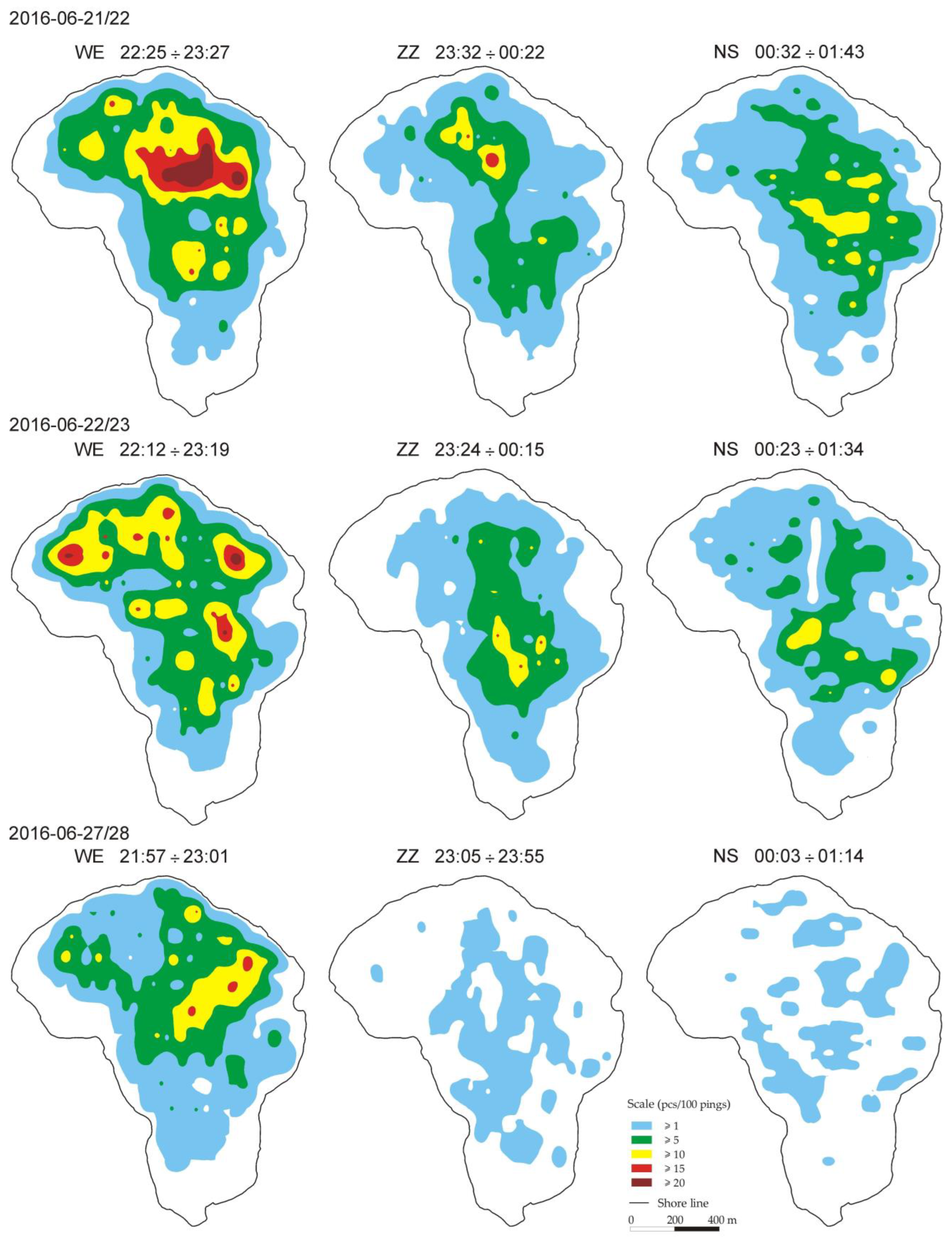
Imaging the probable area where the presence of at least one fish (n ≥ 1) or more could be registered in layers 2–4 m and 4–6 m using the kriging method procedure in the Surfer program confirmed significant changes in the distribution of fish during the research (Figure 7 and Figure 8). At the same time, it indicated that, at least in the case of Lake Widryńskie, assessing changes in the size of the surface area greater than five individuals/100 pings may lead to erroneous conclusions. In as many as two out of nine of the analyzed repetitions (recorded on the night of 27/28 June) it was not possible to demonstrate such densities, and it was not the result of a change in the number of fish or a change in habitat conditions. This was due to the spatial heterogeneity of the fish. As pointed out by Kelly et al. [3], communities show both spatial and temporal heterogeneity. The problem of the low repeatability of the research was undoubtedly the result of the concentration of fish in the epilimnion and the physical limitations of a shallow water environment in acoustic research, which leads to fish being avoided and errors in estimates [34,35].
These findings are confirmed by the values of the coefficient of variation in the size of the area in layers 2–4 m and 4–6 m. The CV of the area in the layer 2–4 m, where the registration of fish (n > 1) could be expected, was 6.5%. According to the adopted grading scale, it can be concluded that the differences were relatively small. In the other two analyzed cases, i.e., for n > 5 and n > 10 fish, the CV was 34% and 63%, respectively, which indicated very high variability. In the 4–6 m layer, the CV values for n > 1, n > 5, and n > 10 were 32%, 71%, and 120%, respectively, so they were not only greater than 30%, a threshold value indicating very high variability, but also much higher than the CV values determined in the 2–4 m layer. This could be related to a much smaller number of fish detected during the research, which could have resulted in greater fish avoidance during the research.
The existence of large or very large differences in the size of the area where fish could be found in individual areas is also indicated by boxplots (Figure 9). Even for areas with n > 1 in the 2–4 m layer, as many as two values recorded along EW transects (from 21/22 and 27/28 June) did not meet the IQR criterion and were marked as outliers. A comparison of these results with the remaining ones showed a statistically significant true difference between these results with a significance level of p = 0.014 and p = 0.004, respectively. They were 10% smaller and 14% larger, respectively, than the average area determined from the remaining repetitions.
In the 4–6 m layer, the outlier results were the areas for n > 1 determined on the night of 27/28 June along the NS and ZZ transects. They differed significantly from the mean value by as much as 56% and 66% of its value, with p < 0.001. Adopting these results in analyses of changes in ecological status could result in a significant error.
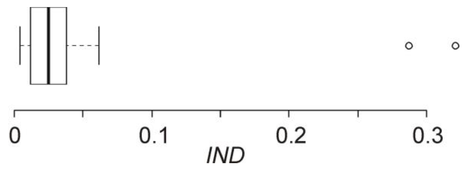
The IND coefficient calculated according to Equation (3) ranged from 0.004 to 0.036 (average: 0.019 for n = 9). The maximum IND value for Lake Widryńskie was close to the value of IND = 0.041 in the 2–16 m layer in Lake Dejguny in 2008 (Figure 10), in which the TS distribution structure of fish was similar to that in Lake Widryńskie (according to Hutorowicz, unpublished data), almost eight times smaller than the value of IND in the layer from 2 to 34 m, and almost nine times smaller than in the layer of 16–34 m in Lake Dejguny, which in 2008 was dominated by fish with TS > −41 dB [19].
As already mentioned, the IND coefficient was modeled on the large fish indicator, which was developed by Greenstret et al. for use in the North Sea, and is the proportion of the total fish biomass of a given set of species in a given water body that exceeds a specified threshold length [36]. This indicator allows one to determine the diversity of the size and structure of specific fish communities and reflects changes in the population size and structure of individual species, as well as changes in the relative abundance of species with different body lengths [37]. The IND indicator proposed in the previous publication [33] is based not on fish biomass but on the number of fish with a specific target strength, and its meaning is assumed to be identical to the large fish indicator. It was concluded that the large fish indicator, which effectively shows the disproportionately increased relative abundance of smaller fish compared to larger individuals, may be a good metric for assessing “the ecological status (“health”) of fish communities” [38], especially those that are influenced by fisheries with strong size-selective pressures, resulting in high mortality rates among larger fish [39]. However, it can be assumed that this metric of size composition will be equally effective in assessing changes in the structure of fish communities that are caused by other reasons.
Practice has shown that the large fish index is not a universal index enabling the assessment of different fish communities in all regions [32]. This indicator had to be adapted to assess changes in another group of species in the Celtic Sea. A different length threshold was adopted to define large fish and a different target percentage of large fish in the community was set [32]. Admittedly, the threshold for the length of large fish (30 cm) adopted for Lake Dejguny and, based on it, the threshold value of TS = −38 dB [33] also turned out to be appropriate for assessing the structure of fish in Lake Widryńskie. However, this does not rule out the fact that it may be necessary to adapt the IND to local conditions in the future. It will be necessary to establish a different TS threshold for large fish. This necessity is suggested by unpublished, partial results obtained in Jeziora Pluszne [40].

4. Conclusions and Future Research Directions

Research has shown that in shallow waters (and also in anthropogenically changed waters, where fish concentrate primarily in the epilimnion), analyses of changes in the area occupied by fish (in layers 2 m deep) and analyses of target strength distribution (TS distribution) in 2 m layers should be based on at least three series of acoustic measurements. This is due to the high probability of collecting heterogeneous data (in this research, the empirical probability was estimated at >20%).
The obtained results do not rule out the usefulness of the proposed IND size composition indicator. However, taking into account its specificity, we propose providing it together with the value of the target strength threshold defining large fish, i.e., taking into account the structure of fish communities in Lake Widryńskie, in the notation “IND−38dB”.
Of course, this research does not exhaust questions related to the proposed method for assessing changes in the ecological state based on acoustic data. Future studies should determine the uncertainty of results in deeper water layers (i.e., below a depth of 10 m). Moreover, in order to determine the “sensitivity” of the described method, it is necessary to collect and analyze acoustic data from long-term monitoring of one lake. Their sensitivity is confirmed by the research of Braun and Mehner [41], according to which the impact of eutrophication on the size spectrum of the pelagic fish community in Lake Stechlin over a 12-year period was reflected only by hydroacoustic methods. They should allow determining the limit values of Kendall’s tau (τ) coefficient, which indicate a different type of fish number pattern in diagrams illustrating the TS distribution in water layers. Long-term data should also make it possible to confirm or reject the usefulness of the analysis of areas where fish are recorded for assessing changes in the ecological status/“health” of fish communities.

Funding

This research was funded by the National Inland Fisheries Research Institute in Olsztyn as part of the statutory research activity (topic no. Z-017).

Data Availability Statement

Data are contained within the article.

Acknowledgments

I would like to thank Lech Doroszczyk and Marcin Białowąs, who were involved in field work related to the acquisition of acoustic data used in this study. Separately, I would also like to express my gratitude to the recently deceased Bronisław Długoszewski, for all the help he often provided me with in hydroacoustic research.

Conflicts of Interest

The author declares no conflicts of interest.

References

  1. Moe, J.; Solheim, A.L. Zintegrowana ocena stanu ekologicznego i szacowanie ryzyka błędnej klasyfikacji [Integrated ecological status assessment and misclassification risk assessment]. In Ecological Status Assessment of the Waters in the Wel River Catchment. Guidelines for Integrated Assessment of Ecological Status of River and Lakes to Support River Basin Management Plans; Wydawnictwo IRS: Olsztyn, Poland, 2010; pp. 267–290. [Google Scholar]
  2. Moe, J.; Solheim, A.L.; Soszka, H.; Gołub, M.; Hutorowicz, A.; Kolada, A.; Picińska-Fałtynowicz, J.; Białokoz, W. Integrated assessment of ecological status and misclassification of lakes: The role of uncertainty and index combination rules. Ecol. Indic. 2015, 48, 605–615. [Google Scholar] [CrossRef]
  3. Kelly, M.; Bennion, H.; Burgess, A.; Ellis, J.; Juggins, S.; Guthrie, R.; Jamieson, J.; Adriaenssens, V.; Yallop, M. Uncertainty in ecological status assessments of lakes and rivers using diatoms. Hydrobiologia 2009, 633, 5–15. [Google Scholar] [CrossRef]
  4. Andricevic, R. Ecological quality assessment under uncertainty for transitional and coastal waters: Central Eastern Adriatic Sea study. Ecol. Indic. 2022, 138, 108850. [Google Scholar] [CrossRef]
  5. Szoszkiewicz, K.; Zbierska, J.; Ławniczak, A.E.; Jusik, S.; Szwabińska, M. Makrofty [Macrophytes]. In Ecological Status Assessment of the Waters in the Wel River Catchment. Guidelines for Integrated Assessment of Ecological Status of River and Lakes to Support River Basin Management Plans; Wydawnictwo IRS: Olsztyn, Poland, 2010; pp. 39–53. [Google Scholar]
  6. Hutorowicz, A.; Napiórkowska-Krzebietke, A.; Pasztaleniec, A.; Hutorowicz, J.; Solheim, A.L.; Skjelbred, B. Fitoplankton [Phytoplankton]. In Ecological Status Assessment of the Waters in the Wel River Catchment. Guidelines for Integrated Assessment of Ecological Status of River and Lakes to Support River Basin Management Plans; Wydawnictwo IRS: Olsztyn, Poland, 2010; pp. 143–168. [Google Scholar]
  7. Loga, M. An Estimation of Uncertainty Measures, Confidence and Precision, of Surface Water Status Assessment. Ochr. Sr. 2016, 38, 15–23. [Google Scholar]
  8. Loga, M.; Wierzchołowska-Dziedzic, A. Probability of misclassifying biological elements in surface waters. Environ. Monit. Assess. 2017, 189, 647. [Google Scholar] [CrossRef]
  9. Hutorowicz, A.; Pasztaleniec, A. Uncertainty in phytoplankton–based lake ecological status classification: Implications of sampling frequency and metric simplification. Ecol. Indic. 2021, 127, 107754. [Google Scholar] [CrossRef]
  10. Mouget, A.; Goulon, C.; Axenrot, T.; Balk, H.; Lebourges-Dhaussy, A.; Godlewska, M.; Guillard, J. Including 38 kHz in the standardization protocol for hydroacoustic fish surveys in temperate lakes. Remote Sens. Ecol. Conserv. 2019, 5, 332–345. [Google Scholar] [CrossRef]
  11. CSN EN 15910; Water Quality—Guidance on the Estimation of Fish Abundance with Mobile Hydroacoustic Methods. 2014. p. 41. Available online: https://standards.iteh.ai/catalog/standards/cen/4ba5b80e-c23b-4b25-b52f-acea4339c28a/en-15910-2014 (accessed on 22 April 2024).
  12. Guillard, J.; Lebourges-Dhaussy, A.; Balk, H.; Colon, M.; Jóźwik, A.; Godlewska, M. Comparing hydroacoustic fish stock estimates in the pelagic zone of temperate deep lakes using three sound frequencies (70, 120, 200 kHz). Inland Waters 2014, 4, 435–444. [Google Scholar] [CrossRef]
  13. Andrade, F.M.; Prado, I.G.; Loures, R.C.; Zambaldi, L.P.; Pompeu, P.S. Hydroacoustic evaluation of the spatial and temporal distribution of fish in the upstream proximity of a dam in a neotropical reservoir. Acta Ichthyol. Piscat. 2019, 49, 329–339. [Google Scholar] [CrossRef]
  14. Girard, M.; Goulon, C.; Tessier, A.; Vonlanthen, P.; Guillard, J. Comparisons of day-time and night-time hydroacoustic surveys in temperate lakes. Aquat. Living Resour. 2020, 33, 9. [Google Scholar] [CrossRef]
  15. Jůza, T.; Muška, M.; Blabolil, P.; Kočvara, L.; Sajdlová, Z.; Dumpis, J.; Medne, R. Spatial fish distribution in autumn in a shallow mesotrophic lake, assessed by hydroacoustic surveys, trawling, and beach seining. J. Fish Biol. 2024. [Google Scholar] [CrossRef]
  16. Rudolfsen, T.A.; Watkinson, D.A.; Charles, C.; Kovachik, C.; Enders, E.C. Developing habitat associations for fishes in Lake Winnipeg by linking large scale bathymetric and substrate data with fish telemetry detections. J. Great Lakes Res. 2021, 47, 635–647. [Google Scholar] [CrossRef]
  17. Mrnak, J.T.; Sikora, L.W.; Jake Vander Zanden, M.; Hrabik, T.R.; Sass, G.G. Hydroacoustic Surveys Underestimate Yellow Perch Population Abundance: The Importance of Considering Habitat Use. N. Am. J. Fish. Manag. 2021, 41, 1079–1087. [Google Scholar] [CrossRef]
  18. Guo, A.; Yuan, J.; Chu, T.; Lian, Q. Hydroacoustic assessment of fish resources in three reservoirs: The effects of different management strategies on fish density, biomass and size. Fish. Res. 2019, 215, 90–96. [Google Scholar] [CrossRef]
  19. Hutorowicz, A. Use of Hydroacoustic Methods to Assess Ecological Status Based on Fish: A Case Study of Lake Dejguny (Poland). Water 2024, 16, 282. [Google Scholar] [CrossRef]
  20. Raport o Stanie Środowiska Województwa Warmińsko-Mazurskiego w 2008 roku [Report on the State of the Environment in the Warmian-Masurian Voivodeship in 2008]; Biblioteka Monitoringu Środowiska: Olsztyn, Poland, 2009; pp. 1–151.
  21. Algen, A. Random Errors of Acoustic Fish Abundance Estimates in Relation to the Survey Grid Density Applied; FAO Fisheries Report; FAO: Rome, Italy, 1983; Volume 300, pp. 293–298. [Google Scholar]
  22. Doroszczyk, L.; Długoszewski, B.; Godlewska, M. Badania hydroakustyczne ichtiofauny jeziora Hańcza [Hydroacoustic studies of the ichthyofauna of Lake Hańcza]. In Środowisko I Ichtiofauna Jeziora Hańcza [Environment and Ichthyofauna of Lake Hańcza]; Wydawnictwo IRS: Olsztyn, Poland, 2008; pp. 191–201. [Google Scholar]
  23. Białowąs, M.K. Wykorzystanie Tradycyjnych Technik Połowu i Metod Hydroakustycznych do Oceny Populacji Sielawy (Coregonus albula) w Jeziorze Widryńskim [Assessment of Vendance (Coregonus albula) Population Using Hydroacoustics and Fish nets—Example of Lake Widryńskie]. Master’s Thesis, University of Warmia and Mazury in Olsztyn, Olsztyn, Poland, 2017. [Google Scholar]
  24. Simrad PX Configurator. Catch Monitoring Software. Reference Manual (Release 22.4). 2022. Available online: https://www.simrad.online/cm/pxc/ref/pxc_ref_en_a4.pdf (accessed on 22 April 2024).
  25. Emmrich, M.; Winfield, I.J.; Guillard, J.; Rustadbakken, A.; Vergès, C.; Volta, P.; Jeppesen, E.; Lauridsen, T.L.; Brucet, S.; Holmgren, K.; et al. Strong correspondence between gillnet catch per unit effort and hydroacoustically derived fish biomass in stratified lakes. Freshw. Biol. 2012, 57, 2436–2448. [Google Scholar] [CrossRef]
  26. Godlewska, M.; Długoszewski, B.; Doroszczyk, L.; Jóźwik, A. The relationship between sampling intensity and sampling error—Empirical results from acoustic surveys in Polish vendace lakes. Fish. Res. 2009, 96, 17–22. [Google Scholar] [CrossRef]
  27. Prchalová, M.; Kubečka, J.; Říha, M.; Mrkvička, T.; Vašeka, M.; Jůza, T.; Kratochvíl, M.; Peterka, J.; Draštíka, V.; Křížekd, J. Size selectivity of standardized multimesh gillnets in sampling coarse European species. Fish. Res. 2009, 96, 51–57. [Google Scholar] [CrossRef]
  28. Tušer, M.; Guillard, J.; Rustadbakken, A.; Mehner, T. Comparison of fish size spectra obtained from hydroacoustics and gillnets across seven European natural lakes. Can. J. Fish. Aquat. Sci. 2022, 79, 2179–2190. [Google Scholar] [CrossRef]
  29. Walesiak, M. Zagadnienie oceny podobieństwa zbioru obiektów w czasie w syntetycznych badaniach porównawczych [On the problem of similarity of sets of the same objects in time in synthetic comparative studies]. Przegląd Stat. 1993, 40, 95–102. [Google Scholar]
  30. Van Aswegen, A.S.; Engelbrecht, A.S. The relationship between transformational leadership, integrity and an ethical climate in organisations. S. Afr. J. Hum. Resour. Manag. 2009, 7, 1–9. Available online: http://www.sajhrm.co.za (accessed on 24 February 2024). [CrossRef]
  31. Iwaniszewska, C. Matematyka dla Biologów [Mathematics for Biologists]; Uniwersytet Mikołaja Kopernika: Toruń, Poland, 1974; pp. 1–89. [Google Scholar]
  32. Modica, L.; Velasco, F.; Preciado, I.; Soto, M.; Greenstreet, S.P.R. Development of the large fish indicator and associated target for a Northeast Atlantic fish community. ICES J. Mar. Sci. 2014, 71, 2403–2415. [Google Scholar] [CrossRef]
  33. Hutorowicz, A.; Ulikowski, D.; Tunowski, J. Comparison of Size Distribution of Fish Obtained from Gill Netting and the Distributions of Echoes from Hydroacoustics in Lake Dejguny (Poland). Water 2023, 15, 1117. [Google Scholar] [CrossRef]
  34. Draštik, V.; Kubečka, J. Fish avoidance of acoustic survey boat in shallow waters. Fish. Res. 2005, 72, 219–228. [Google Scholar] [CrossRef]
  35. Godlewska, M.; Długoszewski, B.; Doroszczyk, L. Day/night effects of passing boat on fish distribution in the shallow Malta reservoir. Hydroacoustics 2009, 12, 61–68. [Google Scholar]
  36. Greenstreet, S.P.R.; Rogers, S.I.; Rice, J.C.; Piet, G.J.; Guirey, E.J. Development of the EcoQO for the North Sea fish community. ICES J. Mar. Sci. 2011, 68, 1–11. [Google Scholar] [CrossRef]
  37. Shephard, S.; Fung, T.; Houle, J.E.; Farnsworth, K.D.; Reid, D.G.; Rossberg, A.G. Size-selective fishing drives spcies composition in the Celtic Sea. ICES J. Mar. Sci. 2012, 69, 223–234. [Google Scholar] [CrossRef]
  38. Greenstreet, S.P.R. Biodiversity of North Sea fish: Why do the politicians care but marine scientists appear oblivious to this issue? ICES J. Mar. Sci. 2008, 65, 1515–1519. [Google Scholar] [CrossRef]
  39. Beverton, R.J.H.; Holt, S.J. On the dynamics of exploited fish populations. Fish. Investig. 1957, 19, 1–533. [Google Scholar]
  40. Hutorowicz, A. (Hydroacoustic Laboratory, National Inland Fisheries Research Institute, Olsztyn, Poland). Analysis of the IND index value in Lake Pluszne (Poland). 2024; (Unpublished work). [Google Scholar]
  41. Braun, L.-M.; Mehner, T. Size Spectra of Pelagic Fish Populations in a Deep Lake—Methodological Comparison between Hydroacoustics and Midwater Trawling. Water 2021, 13, 1559. [Google Scholar] [CrossRef]
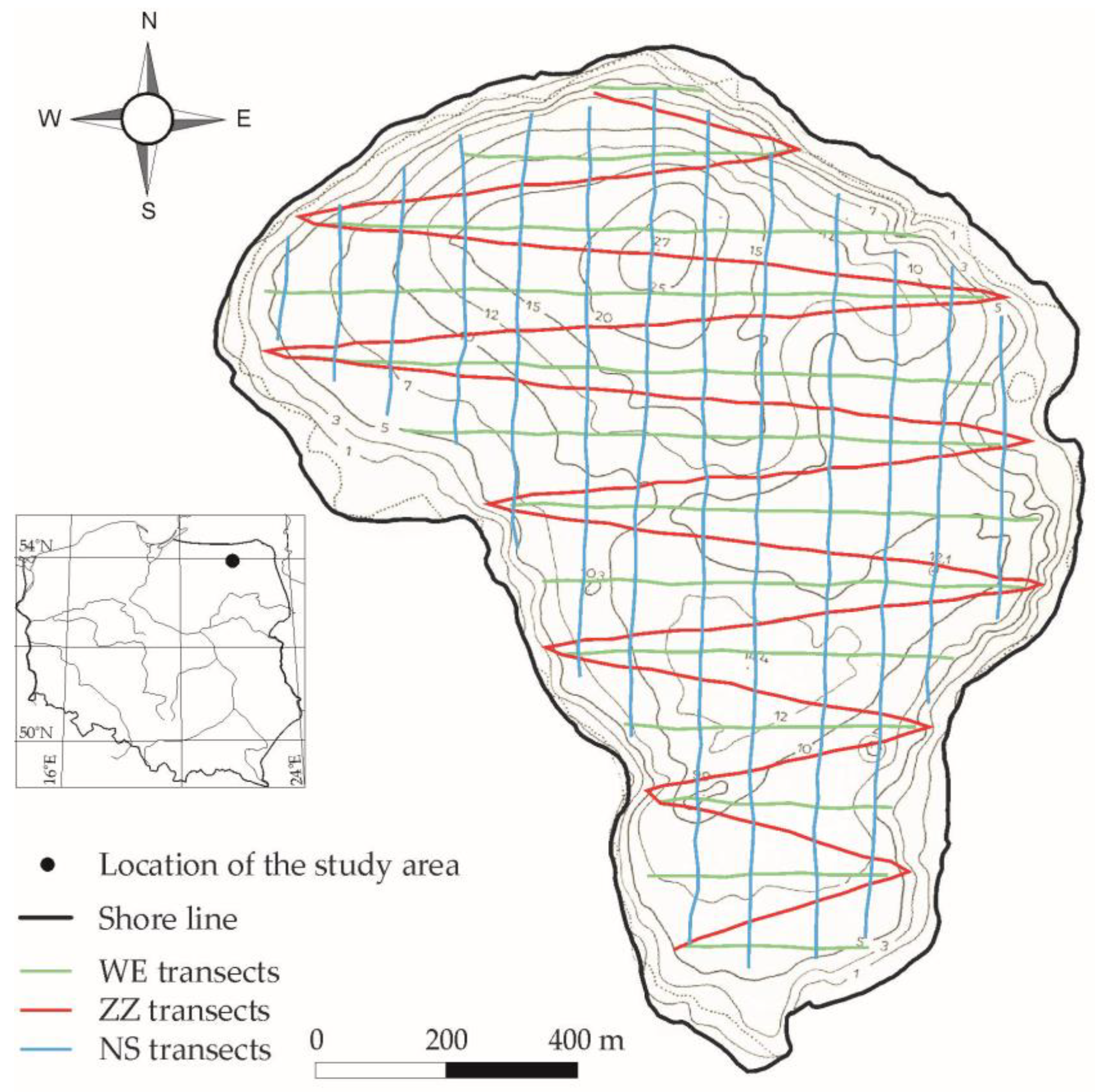
Figure 1. The bathymetric plan of Lake Widryńskie (of the National Inland Fisheries Institute in Olsztyn) with acoustic exploration routes (WE—east–west; ZZ—zigzag transects; NS—north–south) in June 2016.
Water 16 01368 g001
Figure 2. The number of single-fish echoes recorded on transects arranged in the east–west (WE), north–south (NS), and zigzag (ZZ) directions during research carried out on 21/22, 22/23, and 27/28 June 2016 in Lake Widryńskie (a); a boxplot showing the diversity of these data and a lack of potential outliers (b).
Water 16 01368 g002
Figure 3. Target strength (TS) distribution in Lake Widryńskie based on tests conducted on 21/22, 22/23, and 27/28 June 2016 in Lake Widryńskie.
Water 16 01368 g003
Figure 4. Target strength (TS) distribution (average TS from 9 measurements in dB) at a depth of 0–24 m (a) and temperature and oxygen profiles (b) in Lake Widryńskie on June 21/22, 22/23, and 27/28, 2016.
Water 16 01368 g004
Figure 5. Target strength (TS) distribution in 2 m layers at a depth of 0 to 10 m on transects arranged in the east–west (WE), north–south (NS), and zigzag (ZZ) directions, which were recorded during research carried out on 21/22, 22/23, and 27/28 June 2016 in Lake Widryńskie. Testing hours are given next to the transect symbols.
Water 16 01368 g005
Figure 6. Number of fish (single-fish echoes) in water layers recorded during hydroacoustic research on Lake Widryńskie being carried out on 21/22, 22/23, and 27/28 June 2016. The circles mark outliers identified by the 1.5 × IQR rule.
Water 16 01368 g006
Figure 7. Mapping the distribution of fish numbers in sections of 100 pings at a depth of 2–4 m in Lake Widryńskie on 21/22, 22/23, and 27/28 June 2016. WE—east–west transects; ZZ—zigzag transects; NS—north–south transects.
Water 16 01368 g007
Figure 8. Mapping the distribution of fish numbers in sections of 100 pings at a depth of 4–6 m in Lake Widryńskie on 21/22, 22/23, and 27/28 June 2016. WE—east–west transects; ZZ—zigzag transects; NS—north–south transects.
Water 16 01368 g008
Figure 9. Variation in the area (A≥1) where fish were recorded (n ≥ 1 individuals/100 pings) and were recorded in larger numbers of n ≥ 5 (A≥5) and n ≥ 10 (A≥10) in sections of 100 pings at depths of 2–4 and 4–6 m in Lake Widryńskie on 21/22, 22/32, and 27/28 June 2016.
Water 16 01368 g009
Figure 10. A boxplot showing the variation in the IND index value, which was estimated on the basis of 9 measurements of the number of fish in three types of transects (WE, ZZ, and NS) in Lake Widryńskie on 21/22, 22/23, and 27/28 June 2016, and the IND value from Lake Dejguny in 2008 and 2016, according to Hutorowicz [19]. Potential outliers (marked with circles) illustrate the diversity of IND values in Lake Dejguny in 2008 in water layers of 2–34 m and 16–34 m (Hutorowicz, unpublished data).
Water 16 01368 g010
Table 1. Guilford’s interpretation of the magnitude of significant correlations (r) after Aswegen and Engelbrecht [30].
Absolute Value of rInterpretation
<0.19Slight; almost no relationship
0.20–0.39Low correlation; definite but small relationship
0.40–0.69Moderate correlation; substantial relationship
0.70–0.89High correlation; strong relationship
0.90–1.00Very high correlation; very dependable relationship
Table 2. Values of Kendall’s τ coefficient when examining the correlation between series and the average of 9 cases of single-fish echoes (nx) in the target strength (TS) intervals in Lake Widryńskie at the end of June 2016.
n 50 n 29 n n−50n−47n−44n−41n−38n−35n−32n−29
WE 21/220.756 **0.833 **0.697 *0.885 **0.947 **0.889 **0.897 **0.724 **0.674 *
ZZ 21/220.756 **0.935 **0.789 **0.840 **0.947 **0.905 **0.813 **1.000 **N
NS 21/220.940 **0.846 **0.877 **0.840 **0.947 **1.000 **0.966 **0.976 **N
WE 22/230.538 *0.667 *0.572 *0.812 **0.947 **1.000 **0.966 **1.000 **0.674 *
ZZ 22/230.657 *0.660 *0.839 **0.872 **1.000 **0.711 **0.983 **1.000 **0.674 *
NS 22/230.773 **0.935 **0.877 **0.872 **0.947 **1.000 **0.966 **1.000 **0.976 **
WE 27/280.872 **0.887 **0.852 **0.928 **0.905 **0.711 **0.915 **0.729 **N
ZZ 27/280.777 **0.685 *0.667 *0.917 **0.919 **0.947 **0.966 **0.810 **0.976 **
NS 27/280.849 *0.738 **0.837 **0.832 **0.872 **1.000 **0.848 **1.000 **0.674 *
Note: Nn = 0; statistically important correlations with p < 0.01—**; p < 0.05—*.
Disclaimer/Publisher’s Note: The statements, opinions and data contained in all publications are solely those of the individual author(s) and contributor(s) and not of MDPI and/or the editor(s). MDPI and/or the editor(s) disclaim responsibility for any injury to people or property resulting from any ideas, methods, instructions or products referred to in the content.