Article

Study on the Typical Environmental Factors in the Middle Part of Zhoushan Fishery Based on HY-1C/D and Other Multi-Source Data

1
Marine Science and Technology College, Zhejiang Ocean University, Zhoushan 316004, China
2
Hubei Key Laboratory of Marine Geological Resources, China University of Geosciences, Wuhan 430074, China
*
Author to whom correspondence should be addressed.
Water 2024, 16(10), 1387; https://doi.org/10.3390/w16101387
Submission received: 27 March 2024 / Revised: 29 April 2024 / Accepted: 8 May 2024 / Published: 13 May 2024
(This article belongs to the Section Oceans and Coastal Zones)

Abstract

:
This study utilizes satellite data, including HY-1C/D, along with reanalysis data, to unveil the typical environmental characteristics of the sea surface in the middle of Zhoushan fishery. The article addresses three main issues. The first one is the development of an ocean primary productivity (OPP) inversion algorithm model. The second one is the study of chlorophyll-α (Chl-α) concentration and OPP distribution characteristics in Zhoushan fishery using China’s domestically produced ocean satellite HY-1C/D CZI data. The last one is the revelation of the characteristics of typical environmental factors on the sea surface at Zhoushan fishery by combining HY-1C/D with multi-source data. The results show the following: (1) The middle part of Zhoushan fishery exhibits significant seasonal and regional variations in Chl-α concentration and OPP. Chl-α concentration ranges mainly between 0.2 and 2.9 µg/L, with higher concentrations in spring and summer and lower Chl-α concentrations in autumn and winter. Spatially, Chl-α concentration gradually decreases from west to east. The OPP in the study area ranges from 100 mg·m−2d−1 to 1000 mg·m−2d−1, with high OPP values distributed on the western side, ranging from 400 mg·m−2d−1 to 1000 mg·m−2d−1, and gradually decreasing seaward. The highest OPP occurs in summer and the lowest in winter. (2) The correlation analysis between Chl-α concentration and OPP revealed a strong positive relationship. Consequently, this study developed an empirical model for estimating OPP based on Chl-α concentration and validated its feasibility. The model applies to areas with Chl-α concentrations ranging from 0.2 to 4 µg/L. (3) The convergence of freshwater injection, multiple ocean currents, and seasonal upwelling in the study area brings about a rich supply of nutrients. Additionally, the region is characterized by suitable conditions, including optimal Chl-α concentrations, OPP, SST, salinity, currents, and geological water depths. The synergistic effect of these factors together contributed to the formation of Zhoushan fishery.

1. Introduction

The ocean environment has a significant impact on the distribution of fishery resources. Changes in water environmental factors such as chlorophyll-α (Chl-α) concentration [1], ocean primary productivity (OPP) [2], sea surface temperature (SST) [3], salinity [4], nutrients, and phytoplankton can affect the activity and growth of fish resources.
Chl-α concentration is one of the crucial parameters for the remote sensing of ocean color. It is also an important parameter for measuring the distribution of phytoplankton and assessing the level of eutrophication in seawater [5].
The convergence zone between the Kuroshio and Subarctic Boundary Current in the North Pacific Ocean exhibits distinct frontal features in terms of Chl-α concentration. The gradient distribution pattern of Chl-α concentration correlates with the distribution of the central fishery [6]. Prior studies found that squid fisheries occur at the edges of the frontal zone of Chl-α areas during summer and autumn [7]. J. Lumban Gaol [8] analyzed Chl-α concentration and Sardinella lemuru catch in the Bali Strait from 1997 to 1999. The study revealed a fluctuating trend in sardine catch, with Chl-α concentration showing a significant positive correlation with sardine capture. Zhu Wenbin [9] analyzed the distribution characteristics of Engraulis japonicus fry resource density along the coast of Zhejiang and investigated the environmental factors influencing its distribution. The results indicated a positive and linear correlation between Chl-α concentration and the resource density of Engraulis japonicus fry.
OPP plays an important role in the formation of fisheries. Estimating OPP is of great significance to fishery resource management. OPP refers to the ability of producers such as phytoplankton, benthic plants (including stationary seaweeds, mangroves, and seaweeds), and autotrophic bacteria to produce organic matter through photosynthesis [10]. OPP is influenced by light intensity [11], nutrients [12], temperature [13], salinity [14], and human activities [15]. OPP affects the spatial distribution and abundance of phytoplankton. Therefore, it determines the potential output of marine fisheries.
There are many studies focused on the method of estimating fishery resources by using OPP. Taking mackerel as an example, studies have shown that OPP and standardized Catch Per Unit Effort (CPUE) have a significant non-linear relationship (p < 0.05), which is an inverted parabola. The amount of mackerel resources increases with an increase in OPP, but when OPP further increases, the amount of mackerel resources shows a downward trend [16]. Meanwhile, the relationship between OPP and fish resources in the Northwest Pacific Ocean shows a significant positive correlation (p < 0.05) between the average latitude of the optimal OPP and the latitude of fishing effort from July to November. The position of fishing effort is not randomly distributed in fisheries, and may be affected by the latitude distribution of the optimal OPP [17].
Apart from Chl-α and OPP, measurements of SST have practical value in the research around marine fisheries. Fish tend to swim to areas with suitable temperatures if there is a significant temperature change in the environment [18]. In the East China Sea, the production of Japanese Spanish mackerel is concentrated in the southern fishing ground with higher SST, as well as in the northern fishing ground near the mouth of the Yangtze River with lower SST [10]. Prior studies have found that tuna catch has increased in Eastern Pacific countries with rising SST [19]. The suitable SST for Chilean jack mackerel is 9 °C to 16 °C, and its abundance is positively correlated with the abundance of planktonic organisms [20]. Over the past 15 years, the SST in the Flores Sea has increased by 2.5 °C. This change has impacted the habitats of upper-middle-layer fish in these waters, leading to a decrease in catch volume in areas with a higher than usual temperature [21]. These three key factors combined with other environmental factors join together to contribute to the formation of fisheries.
Traditional monitoring methods often lack effective spatiotemporal analysis, making it challenging to comprehensively monitor spatial, temporal, and representative marine environmental factors, as well as conduct macro-scale research [14]. Satellite remote sensing technology, which is capable of acquiring surface information on a continuous, large scale on a high-precision basis around the clock, is an effective solution to this problem [22]. In recent years, many researchers have analyzed the relationship between various marine environmental factors and fishery resources by combining satellite data [23].
The Haiyang series satellites are ocean water color satellites independently developed and launched by China. HY-1C was launched on 7 September 2018, and HY-1D was successfully launched on 11 June 2020. The latter will carry out joint observations with the HY-1C satellite in the morning and afternoon [24]. The HY-1C/D CZI boasts a resolution of up to 50 m and a swath width exceeding 950 km [25]. Compared to most satellites used in ocean studies, the HY-1C/D CZI can provide clearer images, aiding in the identification and monitoring of smaller oceanic features. Additionally, it enables extensive environmental monitoring. With multiple spectral bands, the HY-1C/D CZI can capture various types of environmental information. It excels in specific applications such as green algae blooms, sea ice, nearshore aquaculture, and typhoon remote sensing monitoring, providing more accurate monitoring results [24]. Hongquan Xie et al. [26] used HY-1B satellite L2 data in the Yellow Sea region in 2014 with VGPM and GIS technology to estimate marine primary productivity and analyze the temporal and spatial changes in ocean environmental factors. HY-1C and HY-1D, combined, have great application potential in investigating fishery environmental factors.
Zhoushan fishery possesses unique geographical conditions that make it an excellent fishing ground and the largest offshore fishing ground in China [27]. The abundant aquatic resources in Zhoushan fishery support a diverse ecosystem, including over 300 species of fish. It is well known for its abundant production of large yellow croaker, little yellow croaker, hairtail, and cuttlefish [28].
This study delves into the environmental features of fishing grounds, taking into account a range of factors such as Chl-α concentration, OPP, seawater temperature, the dynamics of current, wind, and salinity, and the depth of the water. This study aims to achieve three main objectives: (1) To establish an OPP inversion algorithm model, exploring the application potential of China’s domestic water color satellite HY-1C/D. (2) To utilize domestic marine satellite HY-1C/D CZI data to deeply investigate the spatiotemporal distribution characteristics of Chl-α concentration and OPP in Zhoushan fishery, providing references for regional marine environmental management. (3) To integrate HY-1C/D and other multi-source data to systematically analyze the characteristics of and variations in surface environmental factors in Zhoushan fishery, revealing the interrelationships between fisheries and environmental factors, and providing a scientific basis for future fisheries’ environmental monitoring and protection.

2. Data and Method

2.1. Study Area

Zhoushan fishery, with an approximate area of 53,000 square kilometers, is the largest fishery in China (Figure 1) [28]. Zhoushan fishery is famous for its rich biodiversity, making it a crucial habitat for numerous species [29]. Benefiting from its unique geographical location, this area is shaped by the intricate interplay of ocean currents and topography, creating habitats conducive to the survival of diverse marine organisms (Figure 1a) [30]. It serves as a vital spawning and feeding ground for a multitude of economical fish and shrimp species [31].

2.2. Satellite Data

HY-1C and HY-1D were launched on 7 September 2018 and 11 June 2020. Two satellites for combined morning and afternoon observations can increase the number of observations and improve global coverage capability [32]. HY-1C and HY-1D are sun-synchronous orbit satellites with an orbit altitude of 789 km. They are equipped with five sensors: a coastal zone imager (CZI), a Chinese ocean color and temperature scanner (COCTS), an ultraviolet imager (UVI), an on-board satellite calibration spectrometer (SCS), and an automatic identification system (AIS).
The CZI can acquire real-time data in areas of sea–land interaction, monitor offshore waters, islands, and coastal zones, and study the distribution of ocean colors in important estuaries and harbors. The spatial resolution is less than 50 m and the width is greater than 950 km. The sensor contains 4 bands, and the parameters are shown in Table 1.
The HY-1C/D satellites provide different levels of products. The L1A products are the DN values for each band, and are radiometrically calibrated to obtain the L1B products. L1B products are atmospherically corrected to obtain the L2A products, which are the basis for the inversion of various oceanographic elements. L2B and L2C data have different application products: L2B contains suspended sediment concentration (SSC) data and the normalized difference vegetation index (NDVI), and L2C products include Secchi disk depth (SDD) and Chl-α concentration. In this study, L2A data from the CZI carried by the HY-1C/D satellite were obtained from the China Ocean Satellite Data Service (https://osdds.nsoas.org.cn/ (accessed on 16 December 2023)).
The Moderate-resolution Imaging Spectroradiometer (MODIS) is a large-scale spaceborne remote sensing instrument developed by NASA (National Aeronautics and Space Administration) and NOAA (National Oceanic and Atmospheric Administration) of the United States. It was first launched aboard the Terra satellite in 1999, and subsequently on the Aqua satellite. MODIS functions as a multispectral sensor, featuring 36 spectral bands with moderate resolution levels (ranging from 0.25 µm to 1 µm), conducting earth surface observations every 1–2 days [33].
MODIS satellite data consist of different levels of products, including raw data (L0), radiometric data (L1A), radiance data (L1B), surface products (L2), statistical data (L3), and model data (L4). Each level of data has different processing and application purposes. MODIS data is obtained from NASA Ocean Color (https://oceancolor.gsfc.nasa.gov/ (accessed on 5 July 2023)).

2.3. In Situ Data and Process

The in situ data comprise two seasonal cruises: one in summer from 10 August to 17 August 2020, and the other in winter from 29 November to 10 December 2020.
The measurement of in situ Chl-α concentration was conducted using spectrophotometry, with the specific steps completed as follows [34]: (1) Collect 500 mL of surface seawater using polyethylene bottles. Add 0.2 mL of magnesium carbonate suspension to a specific volume of the sample, thoroughly mix, and filter using a 60 mm diameter microporous membrane filter. After ensuring the filter is free from moisture, continue suctioning for several minutes. Place the filter membrane containing the concentrated sample in a dark, dry freezer for storage. Proceed with the next steps after the completion of the voyage. (2) Place the filter membrane containing the concentrated sample into a mortar, add 3ml of acetone solution until the filter paper is dampened, grind the filter membrane, and then add a small amount of 90% acetone solution to fully grind the filter membrane. Next, wash the ground filter membrane and acetone solution into a graduated centrifuge tube using 90% acetone solution, with a total volume not exceeding 6 mL, and soak in the dark at 4 °C for 24 h. (3) Place the centrifuge tubes in the centrifuge and centrifuge at a speed of 4000 r/min for 20 min. Transfer the supernatant to a calibrated 10 mL graduated tube, add a small amount of 90% acetone solution to the centrifuge tube containing the original extraction solution, suspend the precipitate again, and centrifuge. Combine the supernatants. Repeat this process 2–3 times until the precipitate is free of pigment. Adjust the volume of the supernatant to 10 mL. (4) Calculate the final Chl-a concentration using spectrophotometry. Set up two parallel samples for all samples, and take the average of the two measurements as the final result.
The measurement of water primary productivity was conducted using the light and dark bottle method, with the specific operational steps completed as follows [35]: First, surface water samples are collected, ensuring an adequate quantity for experimental repeatability. These collected water samples are promptly transferred into pre-prepared light and dark bottles, ensuring they are filled to avoid the formation of air bubbles. The initial dissolved oxygen concentration at the time of bottling is then recorded. Subsequently, these bottles are returned to the environment at a depth of 0.5 m. The white bottles are exposed to natural light for photosynthesis, while the dark bottles are covered to facilitate only respiration. After 24 h of exposure, the dissolved oxygen concentration in the water samples within the bottles is measured again. By comparing the changes in dissolved oxygen concentration between the light and dark bottles, we calculated the primary productivity of the water.

2.4. Temperature, Wind, Salinity, Current, and Chl-a Concentration Data

SST, wind, salinity, and current data were analyzed to assess the environmental factors in Zhoushan fishery. SST data were derived from the Jet Propulsion Laboratory’s (JPL) Multi-Sensor Level 4 foundation SST merged analysis product. This dataset boasts global multi-scale coverage with exceptional ultra-high spatial resolution, reaching up to 1 km.
The wind data were derived from the Global Ocean Hourly Reprocessed Sea Surface Wind and Stress dataset, which combines scatterometer observations with ECMWF ERA5 reanalysis model variables to provide hourly sea surface wind and stress fields. These data were corrected for biases using temporally averaged difference fields, ensuring the accuracy of the wind measurements. The spatial resolution of these data was 1/12 degree.
The salinity and sea-bottom water potential temperature data were obtained from the Global Ocean Physics Reanalysis dataset, which relies on the real-time global forecasting system of CMEMS. It utilizes the NEMO platform model, driven by ERA5 reanalysis for recent years, and assimilates various observational data through a reduced-order Kalman filter. The spatial resolution of these data was 1/12 degree.
The current data originated from the Global Ocean Physics Analysis and Forecast dataset, provided by the Operational Mercator global ocean analysis and forecast system, with a spatial resolution of 1/12 degree.
Chl-α concentration data were obtained from the biogeochemical hindcast for global oceans dataset, which is produced at Mercator Ocean (Toulouse, France). It uses a PISCES biogeochemical model (available on the NEMO modeling platform). The spatial resolution of these data was 0.25° by 0.25°.
These satellite-derived datasets emanate from multiple reputable institutions, showcasing high spatial resolution and extensive temporal coverage. The accuracy of these data has been verified by institutions and numerous scholars [36,37,38,39,40]. Additionally, in many scientific studies, monthly average data like these are also utilized to unveil the seasonal variation characteristics of environmental elements in a region [38,41,42]. Thus, they enable an in-depth understanding of the environmental conditions within Zhoushan fishery.

2.5. Data Processing

Geometric correction is first performed using a polynomial geometric correction model to remove geometric distortion in the satellite images [43]. Then, the image brightness grayscale values are converted to absolute radiometric brightness, and this process is called radiometric calibration [44]. Atmospheric correction involves removing the radiometric errors caused by atmospheric effects, which mainly include the effects of Rayleigh scattering and aerosol scattering [45]. We choose clear and dry images, which can effectively reduce the influence of aerosols. Rayleigh correction can eliminate most of the atmospheric effects, after which Chl-α concentration and OPP can be effectively inverted [46].
The model [32] used for Chl-α concentration inversion in the waters of Zhoushan fishery, based on HY-1C/1D CZI data, is presented as Equations (1) and (2):
ρ = 12.81 × X 3 + 38.17 × X 2 39.17 × X + 14.9
X = ( B 1 / B 2 ) × ( B 3 / B 2 ) 0.45
Here, ρ represents Chl-α concentration, measured in µg/L. B1, B2, and B3 correspond to the remote sensing reflectance in the first, second, and third bands of the CZI, respectively.
To investigate the relationship between the primary productivity and fishery resources in Zhoushan fishery, this study utilizes MODIS data to infer the OPP of Zhoushan fishery based on the VGPM. The VGPM is a reference model for physiological processes that has the advantages of high estimation accuracy and practicality and has become the main research method for remote sensing research on primary productivity.
Behrenfeld [47] later validated the VGPM, and finally simplified the depth-integrated primary productivity equation as Equation (3).
P P e u = 0.66125 × P o p t B × E 0 E 0 + 4.1 × Z e u × C o p t × D i r r
where P P e u is the primary productivity (in mgC/m2) integrated from the surface layer to the true photic zone; P o p t B t is the maximum rate of carbon fixation in the water column (in mgC/(mgChl·h)); E 0 is the PAR intensity (in mol quanta/m2) at the sea surface; and Z e u is the depth of the photic zone (in m). C o p t is the chlorophyll concentration at P o p t B , which can be replaced by the surface Chl-α concentration (in µg/L). D i r r is the photoperiod (in h).
P o p t B = 0.071 × T   3.2 × 10 3 × T 2 + 3.0 × 10 5 × T 3 C + ( 1.0 + 0.17 × T 2.5 × 10 3 × T 2 + 8.0 × 10 5 × T 3 )
Kameda [48] expressed P o p t B as a function of SST and Chl-α concentration, based on an analysis of the observed data, as Equation (4), where T represents SST and C represents Chl-α concentration.
To enhance the applicability of the VGPM to Case II water, Ye et al. [49] refined the calculation method for euphotic layer depth. They adjusted the computation by utilizing the diffuse attenuation coefficient at 490 nm to estimate the euphotic layer depth, as delineated in Formula (5).
Z e u = 4.605 / [ 1.3386 K d 490 + 0.4215 ]
where Z e u represents the euphotic depth and K d 490 refers to the attenuation coefficient of the 490nm wavelength in the water column.
The model is suitable for Case II water, making it applicable to the study area addressed in this study. After processing and calculating the satellite data, we obtained the monthly average OPP of Zhoushan fisheries in 2017 and 2018.

3. Results

3.1. Chl-α Concentration in Study Area

In this study, MODIS monthly mean Chl-α concentration data for Zhoushan fishery for 24 months in 2017 and 2018 were obtained and analyzed for the study area.
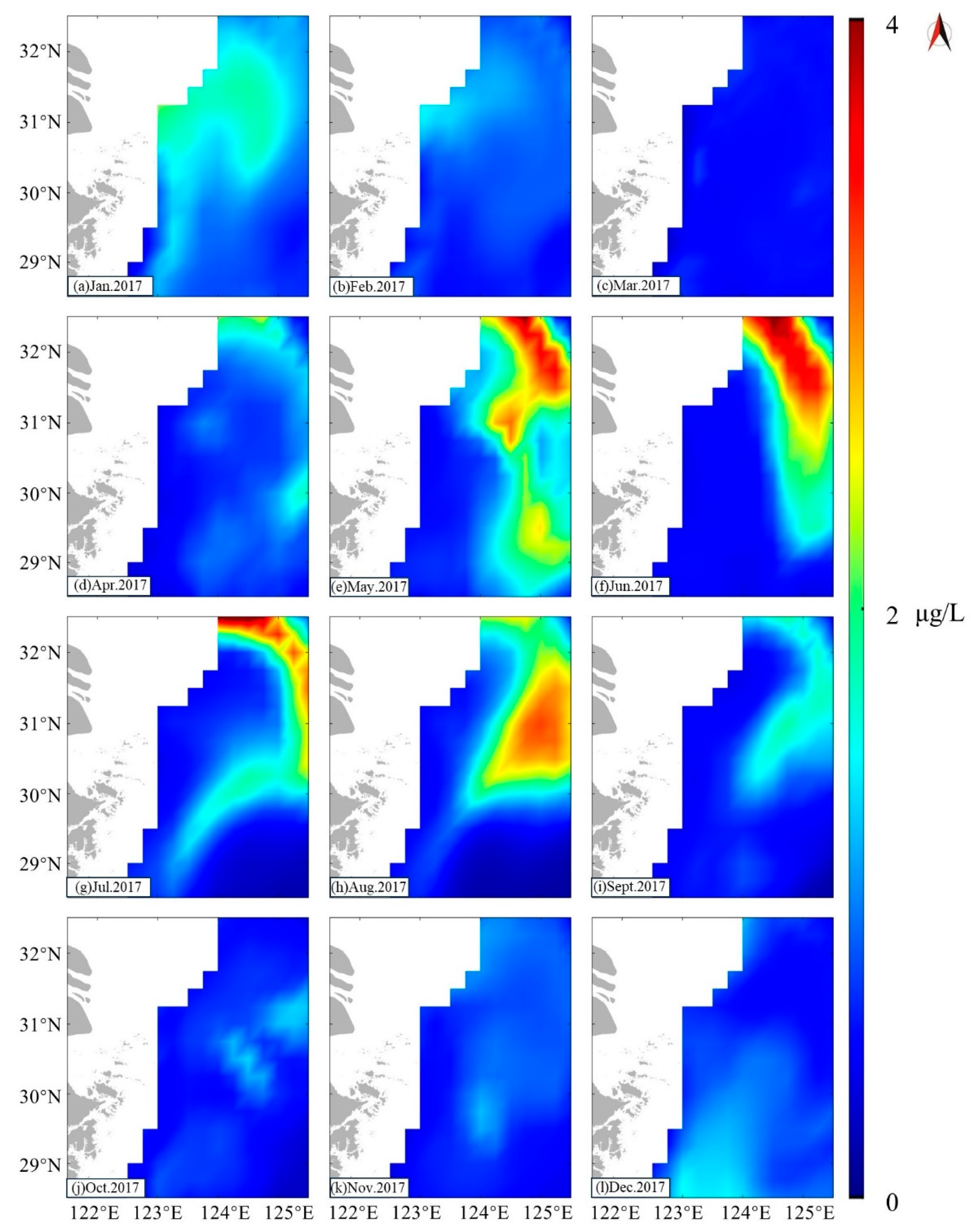
In the study area, we observed distinct seasonal variations in Chl-α concentration, with the highest levels typically occurring in summer, followed by spring and autumn, and the lowest in winter (Figure 2). The Chl-α concentration predominantly ranged from 0.2 to 5 µg/L (Figure 2). Specifically, Chl-α concentration was generally between 1 and 5 µg/L in summer, occasionally reaching up to 7 µg/L in certain offshore regions (Figure 2e–g,q–s). During spring and autumn, Chl-α concentration was similar, approximately spanning from 0.5 to 3 µg/L, with potential increases to around 4 µg/L in some areas (Figure 2b–d,n–p). In winter, Chl-α concentration typically varied between 0.2 and 2.5 µg/L, and could peak at about 3 µg/L in certain western areas (Figure 2a,k–m,w,x).
From October to April, the distribution of Chl-α concentration in the study area was relatively uniform, predominantly ranging from 0.2 to 3 µg/L (Figure 2a–d,j–p,v–x). Notably, in April, the concentration showed a significant increase, reaching up to 5 µg/L (Figure 2d,p). Conversely, from May to September, the Chl-α concentration distribution was more heterogeneous. In the western area of the study area, the concentration was higher, typically varying from about 3 to 5 µg/L, and occasionally peaking at 6 µg/L in certain areas (Figure 2e–i,q–u). Meanwhile, the eastern region exhibited the year’s lower concentration level, ranging from 0.2 to 2 µg/L (Figure 2e–i,q–u).
Meanwhile, we selected a total of 40 HY-1C and HY-1D CZI images from 2019 to 2023 to obtain the Chl-α concentrations in Zhoushan fishery by using the chlorophyll model inversion applicable to Zhoushan fishery, and analyzed the study area. Twenty-five of these images are shown as examples in Figure 3.
In the study area, Chl-α concentration varied between approximately 0.1 and 2.9 µg/L, exhibiting distinct seasonal differences (Figure 3). In spring and summer, Chl-α concentration was higher, typically ranging from 1 to 2.9 µg/L, with peak values observed in summer, occasionally soaring to 5 µg/L in western offshore areas (Figure 3d–p). Conversely, in fall and winter, the Chl-α concentration was comparatively lower, spanning from 0.1 to 1.4 µg/L (Figure 3a–c,q–t). Particularly in winter, most areas recorded Chl-α concentrations below 1 µg/L, with the lowest observed concentration being merely 0.1 µg/L (Figure 3t).
The distribution of Chl-α concentration in the study area has a clear regional character. The Chl-α concentration shows a decreasing trend from west to east (Figure 3). In spring and summer, the distribution of Chl-α concentration is more uniform, with levels slightly higher in the western and southern sides of the study area than in the northern part (Figure 3d–p). In fall, Chl-α concentration is higher in the western side of the study area than in the eastern side (Figure 3q–s). In winter, Chl-α concentration is lower in the central and southeastern parts of the study area and higher in the western and northern regions (Figure 3a–c,t).
After obtaining the Chl-α concentrations in Zhoushan fishery using the HY-1C/D CZI, we validated the remotely sensed Chl-α concentration data against the in situ Chl-α concentration measurements. The results are depicted in Figure 4. Following a correlation analysis, we achieved a determination coefficient (R2) of 0.90 and a root mean square error (RMSE) of 0.21, which indicates that the chlorophyll data acquired by HY-1C/D for the Zhoushan fishery are reliable.
We obtained the distribution of Chl-α concentration at a water depth of 40 m in the Zhoushan fishing grounds using reanalysis data (Figure 5).
In the study area, Chl-α concentration at a depth of 40 m was significantly lower than that at the sea surface, yet it exhibited similar seasonal variation characteristics. Periods of high concentration were predominantly concentrated in the summer season, with the highest concentration typically found in the eastern side of the study area. The maximum Chl-α concentration value reached up to 3.5 μg/L during the peak of summer (Figure 5f-h). As autumn approached, the high-concentration areas remained on the eastern side of the study area but decreased to around 2 μg/L (Figure 5i). In January, the distribution of Chl-α concentration at a depth of 40 m was more uniform, with an average value of 1.8 μg/L (Figure 5a). For the majority of the time and across most of the study area, the Chl-α concentration remained below 1 μg/L.

3.2. Distribution of Monthly Mean OPP

The OPP mainly ranged from 100 to 1000 mg·m−2 d−1 (Figure 6). It was higher closer to the islands, with values of 400 to 1000 mg·m−2 d−1 (black-dashed ellipses in Figure 6). It decreased towards the open sea, with values in the range of 100 to 700 mg·m−2 d−1 (black-dashed squares in Figure 6). The OPP in the study area region exhibited a distinct seasonal variation. The lowest OPP occurred in winter (Figure 6a,b,l–n,x), around 300~400 mg·m−2 d−1, and then gradually increased month by month. The highest values were observed in July and August (Figure 6g,h,s,t). The OPP in spring and autumn was approximately the same, ranging from 400 to 700 mg·m−2 d−1(Figure 6c–e,j–k,o–q,u–w).
The areas with higher OPP (black-dashed ellipses in Figure 6) were concentrated in the coastal regions west of 124° E, parallel to the coastline. In the area east of 124° E and south of 31° N (black-dashed squares in Figure 6), the OPP was generally below 200 mg·m−2 d−1, except in spring when it increased to around 400 mg·m−2 d−1, in some areas even reaching 700 mg·m−2 d−1 (Figure 6d,p). In the regions closer to the open sea and at higher latitudes (red-dashed circles in Figure 6), the OPP followed a similar pattern, with the highest values in summer, followed by spring and autumn, and the lowest in winter (Figure 6).

3.3. The Relationship between Chl-α Concentration and OPP

To investigate the relationship between Chl-α concentration and OPP, we employed a pixel-by-pixel method to compute their correlation within the study area. We have included an additional analysis correlating in situ Chl-a concentration with OPP to further confirm the relationship between the two.
Based on the correlation analysis of Chl-a and OPP obtained by MODIS, we calculated a Pearson correlation coefficient of 0.78 between Chl-α concentration and OPP. Simultaneously, we conducted an in situ correlation analysis of Chl-a and OPP, yielding a correlation coefficient of 0.83. The combination of these two results demonstrates a significant positive correlation between the variables (Figure 7). This means that as the Chl-α concentration increases, the OPP also shows an increasing trend. Chl-α, as a key indicator of marine phytoplankton abundance, has a direct impact on OPP. Phytoplankton convert inorganic carbon into organic matter through photosynthesis [50]. Therefore, under appropriate environmental conditions such as sufficient light and adequate nutrition, the increase in Chl-α concentration usually affects the enhancement of OPP.

3.4. Establishment of OPP Inverse Model

This study established an empirical model for the inversion of OPP based on Chl-a concentration, aiming to reveal detailed distribution patterns of OPP in the study area. Linear, exponential, and logarithmic fitting were conducted separately on the selected 60 sets of in situ OPP data and Chl-α concentration data. The results are shown in Table 2.
From the table, it can be seen that the fitting of the polynomial models is better compared to other models. According to the distribution pattern of OPP, as well as the comprehensive evaluation based on R2 and RMSE, the exponential fitting model of Model 3 is the best model, with a coefficient of determination R2 of 0.8377 and an RMSE of 107.65. Therefore, the final empirical inversion model for estimating OPP based on the Chl-a concentration in Zhoushan fishery is determined as shown in Equation (6).
y = 60.66 + 55.9 x + 91.3 x 2 8.24 x 3
where y represents OPP, and x represents Chl-a concentration.
This is an empirical algorithm for estimating OPP based on Chl-α concentration. The model is developed based on satellite data and in situ measurements from Zhoushan fishery and is applicable to case II water. It is specifically tailored to Zhoushan fishery, where the Chl-a concentration ranges from 0.2 to 4 µg/L. To validate the feasibility of the new model, in situ OPP data were used for model verification. The correlation coefficient between the modeled OPP and the in situ OPP data was computed, resulting in R2 = 0.83 and RMSE = 135.19 (Figure 8), indicating that the new model is suitable for estimating OPP in Zhoushan fishery.
Based on the newly established OPP model, we selected 25 Chl-α concentration images to obtain the distribution of OPP in Zhoushan fishery from March 2019 to March 2023, as shown in Figure 9.
The OPP in the study area ranged from 100 to 950 mg·m−2 d−1, exhibiting significant seasonal variations (Figure 9). OPP levels were highest in summer, typically ranging from 300 to 950 mg·m−2 d−1. In spring and autumn, OPP was lower than in summer, ranging from approximately 200 to 500 mg·m−2 d−1. During winter, OPP in the study area was at its lowest, with most areas ranging only from 50 to 300 mg·m−2 d−1. On 18 January 2023, OPP levels were relatively high compared to the winter average, with most areas exceeding 500 mg·m−2 d−1.
The distribution of OPP in the study area exhibits significant regional characteristics. Overall, there is a decreasing trend from west to east. The distribution is relatively uniform in spring and summer. In autumn, OPP is higher on the west side of the study area compared to the east side. In winter, OPP is lower in the central and southeastern parts of the study area, while it is higher in the western and northern parts.

3.5. Temperature in Study Area

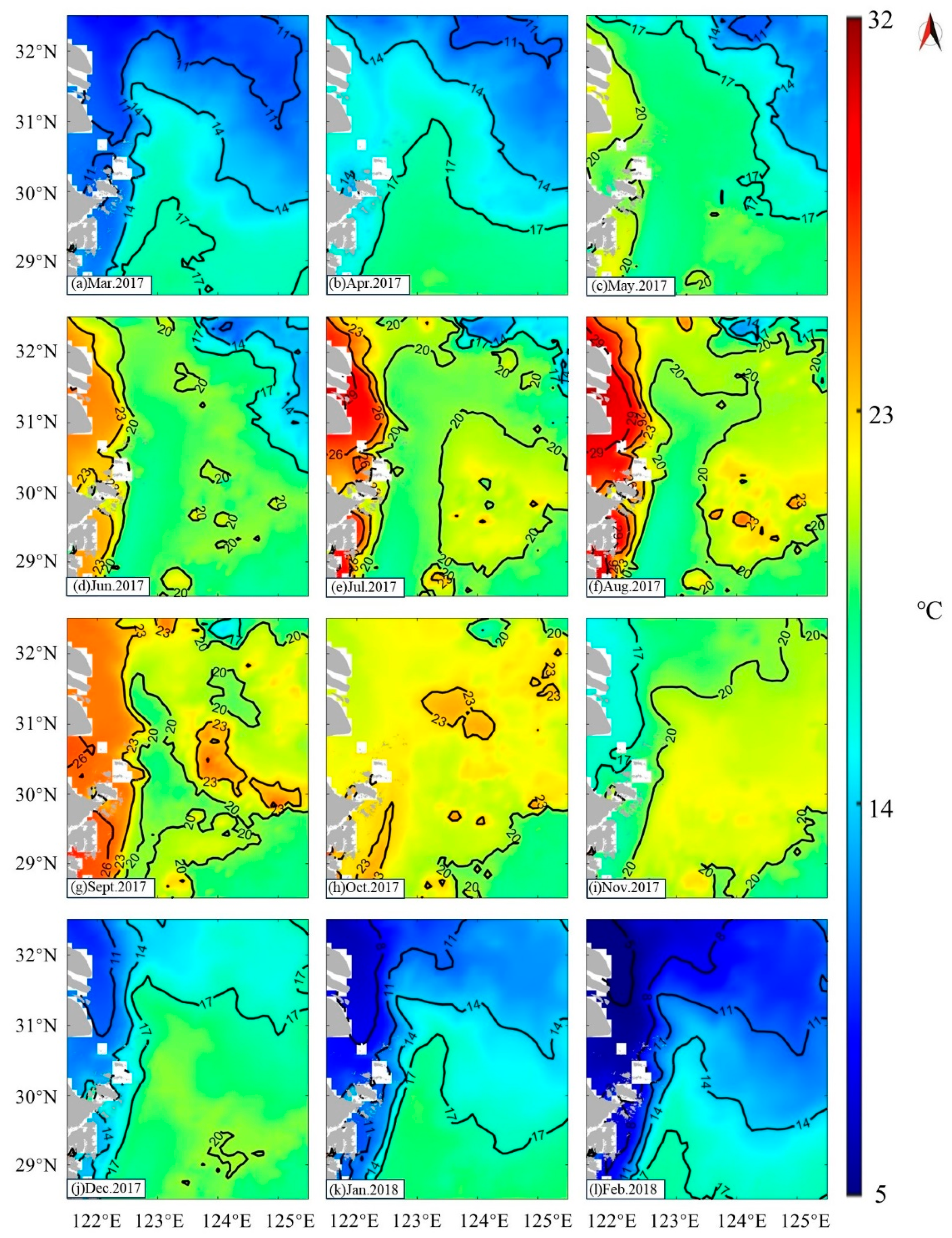
The SST in Zhoushan fishery is generally in the range of 5 °C to 31 °C, showing significant seasonal and spatial variations (Figure 10).
During the summer, the average temperature reaches 29 °C. Near the region of 122.5° E and 30.5° N (black circles), an upwelling phenomenon occurs, causing the water temperature in that area to be lower than in the surrounding areas (Figure 10b–d). In the spring and autumn seasons, the water temperatures in the feeding area region are similar, ranging from 20 to 22 °C (Figure 10a,e–g,k,l). However, during the winter, the SST in this area is at its lowest, ranging from only 10 to 18 °C. During winter, in the maritime region near 123° E and 31° N (red circles), a conspicuous tongue-shaped warm front is observed, characterized by isotherms protruding northward (Figure 10h–j).
The temperature variation in the bottom seawater throughout the year is less pronounced than that of the surface seawater (Figure 11). The lowest monthly average temperature at the seabed within the study area occurs in February, with the minimum temperature being around 10 °C (Figure 11l). Conversely, the highest temperature at the seabed, which is approximately 24 °C, is observed in September (Figure 11g). Similar to the surface seawater, the bottom layer also exhibits distinct seasonal changes, with higher temperatures during the summer and autumn, and lower temperatures in the winter and spring. The greatest difference between the surface and bottom temperatures occurs in the summer, reaching up to a 10 °C differential in August (Figure 11f). In contrast, during the spring and winter, the surface and bottom temperatures are more closely aligned, and their distribution and trends are also similar.

3.6. Hydrological Factors and Salinity

In addition to SST, Chl-α concentration, and OPP, other environmental factors including hydrological conditions and salinity were also analyzed in Zhoushan fishery (Figure 7).
The velocity and direction of currents in Zhoushan fishery undergo significant seasonal variations. During spring (Figure 12a), seawater primarily flows in the northeast direction with relatively slow currents. In summer (Figure 12b), the current velocities increase and shift towards the north, particularly around the nearshore islands and reefs where the currents can be stronger. In autumn (Figure 12c), the predominant current direction is southward and southwestward, accompanied by reduced current velocities. In winter (Figure 12d), the current direction shifts northwestward, resembling the patterns observed in summer.
In the Zhoushan fishery, wind speed and direction vary throughout the year due to seasonal changes, weather patterns, and geographical factors. In spring (Figure 12e), the prevailing winds come from the northeast, with an average speed around 6 to 7 m/s. Areas near Hangzhou Bay and the Yangtze River estuary may experience slightly higher speeds of around 11 m/s. During summer (Figure 12f), the wind speed in the Zhoushan marine area remains relatively stable, mainly influenced by southeast winds typically ranging from 7 to 10 m/s. Winter brings stronger winds to the Zhoushan marine area due to the influence of cold air masses, with north and northeasterly winds being the dominant directions during this season (Figure 12h).
The salinity of the Zhoushan fishery is subject to various influencing factors, including season, tides, freshwater input, and oceanic meteorology. During the summer, salinity exhibits a relatively uniform distribution, with most areas having salinity levels around 33 (Figure 12j). In the Zhoushan archipelago region, there is a dense distribution of isohaline lines. During the spring and autumn seasons, salinity ranges from 30 to 33 (Figure 12i, k). In the winter, the salinity in the study area can exceed 34 (Figure 12l).

4. Discussion

4.1. Factors Contributing to the Formation of Zhoushan Fishery

The study area is located south of the Yangtze River estuary along the western Pacific Ocean. It is a typical spawning and feeding ground, with fertile water, abundant feeding organisms, and a suitable hydrological environment, so it is a good place for various aquatic organisms to reproduce, find bait, and grow [51].
The capacity of Zhoushan fishery to function as a premium feeding ground is determined by a multitude of factors, including SST, depth, Chl-α concentration, OPP, currents, salinity, and wind.

4.1.1. Temperature

The thermal adaptability of different fish species varies significantly, and SST is one of the crucial influencing factors in the formation of fish feeding grounds [52,53]. Zhoushan fishery is located at the convergence of warm and cold oceanic currents, with SST fluctuating between 10 and 30 °C, providing an ideal habitat for fish [54].
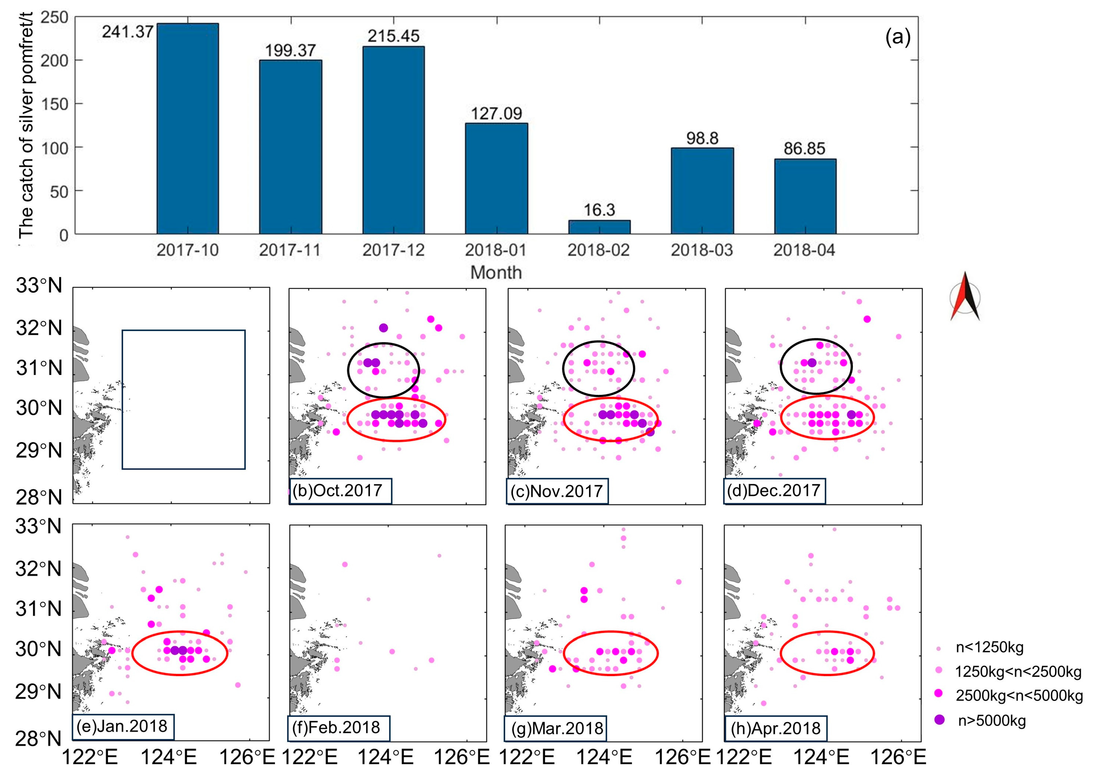
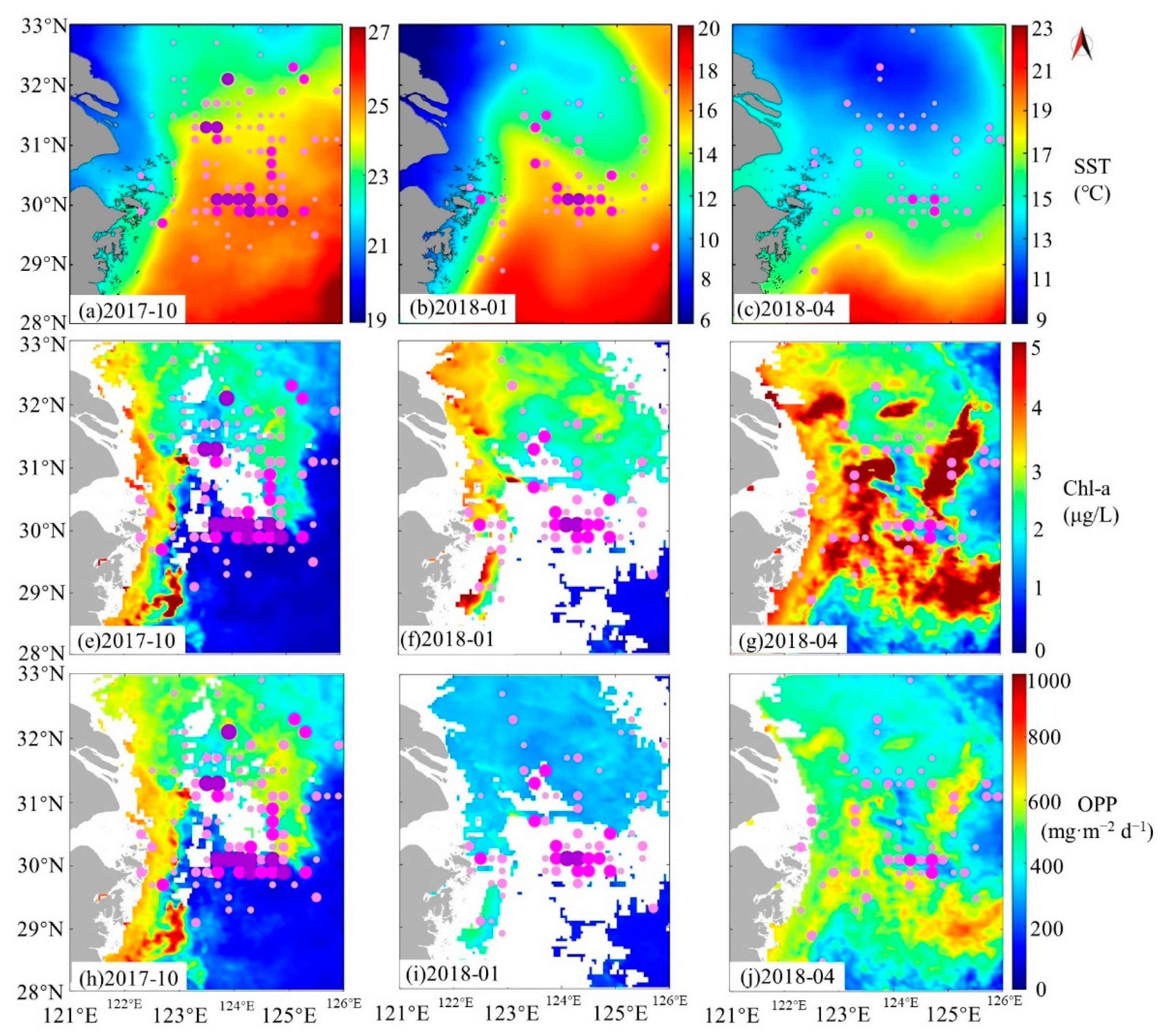
Fish reproduction and feeding behaviors are significantly influenced by water temperature [55]. Most of the fish typical of Zhoushan fishery spawn in spring and summer, and will be active in spawning ground areas after March and April, when SSTs have warmed significantly compared to winter. Silver pomfret is a warm-water pelagic cluster economic fish [56] that is a good example of this phenomenon. The distribution of silver pomfret is closely related to SST. Every spring, as the SST rises, the silver pomfret stock will migrate seasonally from east to west from the deep-water area into the offshore estuarine area. This leads to an increase in silver pomfret stock in Zhoushan fishery in spring (Figure 13). On the contrary, in winter, silver pomfret will go to the deep-water area to overwinter, so the distribution number in Zhoushan fishery will gradually decrease (Figure 13). Additionally, from the monthly catch distribution of silver pomfret, it can be observed that after the decrease in sea temperature, silver pomfret mainly distribute in areas with relatively higher sea temperatures (Figure 14). During the months with higher SSTs, silver pomfret exhibit significant aggregation to both the 30° N and 31.5° N areas. After the SST decreases, the distribution of silver pomfret in the area of 31.5° N becomes less frequent, yet there is still a high-density aggregation at 30° N (Figure 14). The Japanese mackerel is an important pelagic fish in the East China Sea. Research indicates that variations in SST can influence the migratory routes of Japanese mackerel, leading to an uneven distribution of resources [57].

4.1.2. Chl-α and OPP

Chl-α and OPP are directly linked to the formation of marine food chains [58,59,60]. Phytoplankton serves as a key food source for many fish species, and their growth and reproduction are driven by OPP [2,61,62]. Consequently, seasonal variations in Chl-α and OPP levels directly impact the availability of food resources for fish. Spring and summer emerge as periods of elevated Chl-α concentration in Zhoushan fishery, coinciding with heightened OPP during these seasons. In the nearshore region, OPP can exceed 1000 mg·m−2d−1. Abundant sunlight, suitable temperatures, and the injection of Changjiang Diluted Water and other tributaries collectively provide optimal growth conditions, fostering phytoplankton reproduction [63,64]. Fish tend to select areas with higher OPP as feeding grounds due to the abundance of food resources. This phenomenon positions Zhoushan fishery as a thriving feeding area [65].
The silver pomfret has a complex diet, loving aquatic grasses as well as animal bait, with zooplankton and phytoplankton being the favorite foods of this fish [66]. April through June is the breeding season for silver pomfret. Chl-α concentration and OPP, two key marine environmental factors, mutually influence the distribution of silver pomfret. In winter, when Chl-α concentration and OPP are at their lowest, silver pomfret migrate to their overwintering grounds. As spring arrives, the increase in Chl-α concentration and OPP indicates a surge in phytoplankton and other primary producers, attracting silver pomfret to feed. At this time, silver pomfret are distributed in areas with a high Chl-α concentration and a high level of OPP. During the spring and summer, they are active in foraging and spawning grounds, which are characterized by high Chl-α concentration and high OPP. By autumn, after spawning, silver pomfret begins to prepare for the winter. Chl-α concentration and OPP are lower in autumn than in summer, and combined with the high-density aggregation of fish and predation, this results in lower Chl-α concentrations and OPP in areas where silver pomfret are more abundant. In winter, factors such as the drop in SST prevent phytoplankton growth, leading to a decrease in Chl-a concentration and a decline in OPP [67]. Prior to this, silver pomfret were already feeding and reproducing in feeding and spawning grounds, so they were able to migrate to deeper waters to overwinter by winter.

4.1.3. Current and Wind

Zhoushan fishery is situated within a convergence zone of ocean currents, encompassing the influence of Changjiang Diluted Water discharge, the Taiwan Warm Current, and coastal cold currents [68]. The influx of nutrient-rich and organic-laden waters from the Yangtze River and Qiantang River fosters the proliferation of planktonic organisms upon entering the ocean [69]. These planktonic organisms constitute a vital component of the primary food sources for fish. The confluence of cold and warm currents offers fish species a wider array of temperature choices. Thermophilic fish can thrive in the warm current, while cold-water species can inhabit the cold current. Consequently, this favorable condition fosters the survival and proliferation of numerous fish populations in the vicinity of Zhoushan. The convergence of warm and cold currents also generates water turbulence, leading to an influx of copious nutrients, planktonic organisms, and benthic organisms [70,71]. This amalgamation of factors has consequently transformed Zhoushan fishery into a foraging ground.
Zhoushan fishery experiences pronounced seasonal variations in winds, especially during the summer when southerly winds predominate (Figure 7f). According to Ekman’s drift theory, the persistent southerly winds lead to offshore movement of the surface seawater along the southeastern coast, causing a compensatory upwelling of deeper seawater towards the shore. This process creates coastal upwelling (Figure 6d–f). Because upwelling can bring a substantial amount of minerals from the seafloor to the surface, it provides abundant nutrients for aquatic plants near the coast, leading to their luxuriant growth. This flourishing growth of aquatic plants attracts various fish species for feeding and spawning. Consequently, it plays a significant role in the formation of feeding grounds.

4.1.4. Other Factors

Other factors such as water depth and salinity also play a significant role in influencing the distribution of fishery resources and are a crucial factor in the formation of feeding grounds [72,73,74]. The water depth in the feeding ground area ranges from 30 to 80 m. Water depth influences the distribution of planktonic and benthic organisms in the ocean. Shallow waters are more likely to accumulate planktonic organisms, thereby attracting fish in search of food [75]. Suitable water depth provides an optimal habitat, and certain fish species may require specific depth ranges for reproduction and egg hatching [76]. The topography of the Zhoushan fishing ground also has a profound effect on upwelling by guiding the bottom flow upward and regulating the position and intensity of the tidal front [77].
Salinity also influences the distribution of fisheries resources. Within the optimal salinity range, the energy consumed by fish to maintain internal osmotic pressure can be minimized [78]. Changes in salinity beyond the adaptive range of silver pomfret will make the fish show a stress response, but will also affect the silver pomfret’s digestive enzymes, antioxidant enzymes, and the vitality of important regulatory enzymes [79]. Silver pomfret generally spawns near coastal reefs and sandy beaches at a water depth of 10 to 20 m and a salinity between 26.00 and 31.00 [80]. So, Zhoushan fishery’s seawater salinity distribution is suitable for silver pomfret reproduction. Salinity is a major factor promoting the formation of silver pomfret spawning grounds.
Due to the limitations of the data, the types of data we can analyze are limited. In future studies of fishing grounds, we will analyze more data to conduct a more in-depth study of the fishery.

4.1.5. Relationships between Different Environmental Factors

Sea temperature not only affects the metabolism and distribution of organisms, but also has a close relationship with Chl-a concentration [81]. Warm seawater can promote the reproduction of plankton, thereby increasing Chl-a concentration, providing abundant food sources for fish. At the same time, Chl-a concentration is an indicator of primary productivity [82]. A high Chl-a concentration indicates a high abundance of phytoplankton, which may in turn increase OPP. OPP forms the basis of the marine food web, directly affecting the abundance of fishery resources [83]. Regions with high OPP often support more fish and other marine organisms, forming fishing grounds.
Salinity is closely related to water density, playing a crucial role in ocean currents and circulation [84]. Currents and wind play important roles in regulating the distribution of sea water temperature and salinity, while also affecting the transport of nutrients and the aggregation of organisms within the water. Water depth affects the distribution of light, temperature, and pressure in the ocean, exerting a significant influence on habitat selection and the distribution of marine organisms [85]. Different depth zones are suitable for the life of different biological populations [86].
The interaction of these environmental factors constitutes the dynamic balance of the marine ecosystem. Changes in any one of these factors may cause a chain reaction that will have an impact on marine ecology and fishery resources.

4.2. Advantages of the Model

The new OPP model utilizes HY-1C/D CZI data, which feature a high spatial resolution of 50 m, allowing for a detailed study of the characteristics of marine environmental elements. This model is simpler in composition, more convenient in use, and more efficient in calculation than previous models. The model can derive OPP based on chlorophyll data alone, without the need for excessive parameters, thus avoiding errors that can arise from having too many parameters. Other existing models for retrieving OPP require multiple parameters and also have lower resolution. We validated the results obtained from the model using in situ OPP data, indicating that the model has high accuracy and practical application value.

4.3. Suggestions for the Protection and Development of Zhoushan Fishery

Scientific fry release involves the strategic deployment of fish fry based on monitoring data on the fishing environment, taking into consideration the optimal growth conditions and varying life cycles of different fish species. By selecting appropriate timing and locations for fry release, this approach significantly enhances the effectiveness of fry stocking, replenishing losses incurred through fishing activities in the fishery. Given the gradual depletion of nearshore fishery resources, coupled with the underutilization of deep-sea resources, the development of deep-sea marine ranching emerges as a promising avenue for the fisheries industry. The sustainable exploitation of deep-sea marine resources not only serves as a novel direction for fisheries development, but also helps alleviate the strain on nearshore marine resources, contributing to a more balanced and sustainable approach. The implementation of these two measures holds great promise for fostering the sustainable development of fishery resources.
Remote sensing technology holds significant potential for application in fisheries management. Therefore, based on remote sensing technology, we propose three suggestions for the development of Zhoushan fishery: (1) The establishment and enhancement of a marine ecological environment monitoring system. We suggest leveraging remote sensing technology to establish a comprehensive marine ecological environment monitoring system. This system would monitor key indicators such as seawater temperature, chlorophyll concentration, and ocean acidification levels. By integrating field survey data, we can establish a precise assessment system for fishing ground environments and provide data support for the scientific management of fishery resources. (2) Establishing an environmental change early-warning system based on remote sensing data. This system would monitor sudden environmental events such as red tides and marine pollution in real time, mitigating their adverse impacts on fishery resources. (3) Marine ranch planning and management. This would involve utilizing remote sensing technology to assist in the site selection, planning, and management of marine ranches, optimizing their layout to enhance the natural recovery capabilities of marine biological resources.

5. Conclusions

This study analyzed the detailed variations in Chl-α concentration in Zhoushan fishery using HY-1C/D and multi-source data, revealing the detailed distributions of Chl-α concentration and OPP in the middle part of Zhoushan fishery. The feeding ground exhibits significant seasonal and regional variations in Chl-α concentration and OPP. Chl-α concentration ranges mainly between 0.2 and 2.9 µg/L, with higher concentration in spring and summer and lower Chl-α concentration levels in autumn and winter. Spatially, Chl-α concentration gradually decreases from west to east. The OPP in the study area ranges from 100 mg·m−2d−1 to 1000 mg·m−2d−1, with high OPP values distributed on the western side, ranging from 400 mg·m−2d−1 to 1000 mg·m−2d−1, and gradually decreasing seaward. The highest OPP occurs in summer and the lowest in winter.
In this study, a correlation analysis was conducted between Chl-a concentration and OPP, and a significant positive correlation was found between the two. This suggests that as Chl-α concentration increases, there is a corresponding upward trend in OPP. Such a relationship highlights the critical role of Chl-α as a proxy for phytoplankton biomass, which directly influences OPP in marine ecosystems. Essentially, higher Chl-α levels typically reflect greater phytoplankton abundance, leading to increased photosynthetic activity and thus, elevated OPP.
Based on the study of the correlation between Chl-α concentration and OPP, we developed an empirical model for the retrieval of OPP based on Chl-α concentration. The feasibility of this model has been validated and it is applicable to marine areas where the Chl-a concentration ranges from 0.2 to 4 µg/L.
The confluence of various environmental factors collectively contributes to the formation of feeding grounds and spawning grounds. The region is characterized by suitable conditions, including optimal Chl-α concentrations, OPP, SST, salinity, currents, and geological water depths. Situated in a convergence zone of multiple ocean currents, including coastal currents, upwelling currents, and the Kuroshio, the interactive effects of these currents, along with inland runoff, further supply the feeding ground with abundant nutrients, promoting the formation of the fishery.
This study integrates Chinese ocean color satellite HY-1C/D CZI data with multisource information to investigate detailed environmental elements of fishery, thereby exploring the potential application of Chinese ocean color satellites. Simultaneously, it provides valuable insights for the environmental monitoring and sustainable development of coastal fisheries.

Author Contributions

Conceptualization, L.C. and X.Z.; methodology, L.C. and X.Z.; software, X.Z. and M.Y.; validation, X.Z., M.Y. and R.T.; formal analysis, X.Z. and R.T.; investigation, X.Z. and M.Y.; resources, L.C.; data curation, X.Z.; writing—original draft preparation, L.C. and X.Z.; writing—review and editing, X.Z. and R.T.; visualization, X.Z.; supervision, L.C. and X.Z.; project administration, L.C.; funding acquisition, L.C. All authors have read and agreed to the published version of the manuscript.

Funding

This work is supported by the following research projects: Basic Public Welfare Research Program of Zhejiang Province (LGF21D010004); the Science Foundation of Donghai Laboratory (DH-2022KF01010).

Data Availability Statement

Publicly available datasets were analyzed in this study.

Acknowledgments

The authors would like to thank the China Centre for Resources Satellite Data and Application for providing the HY-1C/D CZI data.

Conflicts of Interest

The authors declare no conflicts of interest.

References

  1. Cai, L.; Tang, R.; Yan, X.; Zhou, Y.; Jiang, J.; Yu, M. The Spatial-Temporal Consistency of Chlorophyll-a and Fishery Resources in the Water of the Zhoushan Archipelago Revealed by High Resolution Remote Sensing. Front. Mar. Sci. 2022, 9, 1022375. [Google Scholar] [CrossRef]
  2. Chassot, E.; Bonhommeau, S.; Dulvy, N.K.; Mélin, F.; Watson, R.; Gascuel, D.; Le Pape, O. Global Marine Primary Production Constrains Fisheries Catches. Ecol. Lett. 2010, 13, 495–505. [Google Scholar] [CrossRef] [PubMed]
  3. Boltaña, S.; Sanhueza, N.; Aguilar, A.; Gallardo-Escarate, C.; Arriagada, G.; Valdes, J.A.; Soto, D.; Quiñones, R.A. Influences of Thermal Environment on Fish Growth. Ecol. Evol. 2017, 7, 6814–6825. [Google Scholar] [CrossRef]
  4. Bœuf, G.; Payan, P. How Should Salinity Influence Fish Growth? Comp. Biochem. Physiol. Part C Toxicol. Pharmacol. 2001, 130, 411–423. [Google Scholar] [CrossRef]
  5. Shan, J.; Yicheng, W.; Renfeng, M.A. Change Conalysis of Chlorophyll Concentration in the East China Sea and Its Response to Seawater Temperature. Bull. Surv. Mapp. 2020, 6, 39. [Google Scholar]
  6. Mao, Z.; Zhu, Q.; Gong, F. Satellite remote sensing of chlorophyll a concentration in the north Pacific Fisher. Shuichan Xuebao 2005, 29, 270–274. [Google Scholar]
  7. Fan, X.; Wu, Y. Relation between chlorophyl II and SST fronts of the North Pacific and the distribution of squid fishing grounds. Fish. Inf. Strategy 2016, 31, 44–53. [Google Scholar]
  8. Gaol, J.L.; Pasaribu, B.; Manurung, D.; Endriani, R. The Fluctuation of Chlorophyll-A Concentration Derived from Satellite Imagery and Catch of Oily Sardine (Sardinella Lemuru0) in Bali Strait. Int. J. Remote Sens. Earth Sci. (IJReSES) 2010, 1, 14–30. [Google Scholar] [CrossRef]
  9. Zhu, W.; Zhu, H. Distribution of juvenile anchovy Japonicus and its relationship with environmental factors along the coast of Zhejiang. J. Fish. Sci. China 2021, 28, 1175–1183. [Google Scholar]
  10. Li, G.; Chen, X. Study on the Relationship between Catch of Mackerel and Environmental Factors in the East China Sea in Summer. J. Mar. Sci. 2009, 27, 1–8. [Google Scholar]
  11. Li, W.; Wang, X.; Li, S. Effects of Intensity and Environment Factors on Marine Primary Productivity. J. Xiamen Univ. (Nat. Sci.) 1989, 28, 423–426. [Google Scholar]
  12. Shen, Y.; Zhang, H.; Ma, X.; Kong, D.; Ma, L. The Influence for the Ocean Primary Yield-Power (Chlorofucine) with the Change of Inorganic Nitrogen and Reactive Phosphate in the Bohai Ocean Gulf. Environ. Monit. Chin. 2004, 20, 52–54. [Google Scholar]
  13. Morin, A.; Lamoureux, W.; Busnarda, J. Empirical Models Predicting Primary Productivity from Chlorophyll a and Water Temperature for Stream Periphyton and Lake and Ocean Phytoplankton. J. N. Am. Benthol. Soc. 1999, 18, 299–307. [Google Scholar] [CrossRef]
  14. Xu, P.; Mao, F.; Jin, P.; Cheng, Q. Spatial-Temporal Variations of Chlorophyll-a in Qiandao Lake Using GF1_WFV Data. China Environ. Sci. 2020, 40, 4580–4588. [Google Scholar]
  15. Sun, Q.; Hong, Y.; Lu, F. A Study on the Correlation between the Marine Primary Productivity of Pearl River Estuary and Human Activities. Sci.-Tech Innov. Product. 2019, 12–15. [Google Scholar]
  16. Wenjiang, G.; Xinjun, C.; Feng, G.; Gang, L. Study on the Dynamics of Biomass of Chub Mackerel Based on Ocean Net Primary Production in Southern East China Sea. Haiyang Xuebao 2013, 35, 121–127. [Google Scholar]
  17. Wei, Y.; Xinjun, C.; Qian, Y. Relationship between Spatio-Temporal Dynamics of Neon Flying Squid Ommastrephes Bartramii and Net Primary Production in the Northwest Pacific Ocean. Haiyang Xuebao 2016, 38, 64–72. [Google Scholar]
  18. Murawski, S.A. Climate Change and Marine Fish Distributions: Forecasting from Historical Analogy. Trans. Am. Fish. Soc. 1993, 122, 647–658. [Google Scholar] [CrossRef]
  19. Mediodia, H.J.P. Effects of Sea Surface Temperature on Tuna Catch: Evidence from Countries in the Eastern Pacific Ocean. Ocean Coast. Manag. 2021, 209, 105657. [Google Scholar] [CrossRef]
  20. Zhou, B. A study on the relationship between the distribution of fishing ground of Chilean Jack mackerel (Trachrus murphyi) and marine environment based on the fishery. In Proceedings of the Fishery Science and Technology Innovation and Development Mode Change–2011 Chinese Fisheries Society Annual Meeting Paper Abstract Collection, Xiamen, China, 15 November 2011; p. 592. [Google Scholar]
  21. Putri, A.R.S.; Zainuddin, M.; Musbir, M.; Mustapha, M.A.; Hidayat, R.; Putri, R.S. Impact of Increasing Sea Surface Temperature on Skipjack Tuna Habitat in the Flores Sea, Indonesia. IOP Conf. Ser. Earth Environ. Sci. 2021, 763, 012012. [Google Scholar] [CrossRef]
  22. Fan, W.; Zhou, S.; Cui, X.; Wang, D.; Shen, X. The Application Research and development of Satellite Remote Sensing for Marine Fisheries. J. Ocean. Technol. 2002, 21, 15–21. [Google Scholar]
  23. Yue, H.; Zhao, T.; Chen, L.; Lin, S. Test of the Ocean Color Radiant Models in SeaWiFS Data. Mar. Environ. Sci. 1999, 18, 57–61. [Google Scholar]
  24. Jianqiang, L.; Xiaomin, Y.; Qingjun, S.; Jing, D.; Bin, Z. Products of HY-1C/D Ocean Color Satellites and Their Typical Applications. Natl. Remote Sens. Bull. 2023, 27, 1–13. [Google Scholar]
  25. Tong, C.; Mu, B.; Liu, R.-J.; Ding, J.; Zhang, M.-W.; Xiao, Y.-F.; Liang, X.-J.; Chen, X.-Y. Atmospheric Correction Algorithm for HY-1C CZI over Turbid Waters. J. Coast. Res. 2019, 90, 156–163. [Google Scholar] [CrossRef]
  26. Xie, H.; Guo, C. Spatio-Temporal Variation of Primary Productivity of the Yellow Sea Using HY-1B Satellite Data. Mod. Surv. Mapp. 2017, 40, 13–16. [Google Scholar]
  27. Tang, R.; Cai, L.; Yan, X.; Ye, X.; Xu, Y.; Yin, J. Study of the Response of Environmental Factors of the Coastal Area in Zhoushan Fishery to Typhoon In-Fa Based on Remote Sensing. Remote Sens. 2023, 15, 3349. [Google Scholar] [CrossRef]
  28. Liu, P.; Yu, Y.; Liu, C. Studies on the Situation of Pollution and Countermeasures of Control of the Oceanic Environment in Zhoushan Fishing Ground—The Largest Fishing Ground in China. Mar. Pollut. Bull. 1991, 23, 281–288. [Google Scholar] [CrossRef]
  29. Ni, H.; Lu, J. Present Utilization Situation of Main Fishery Resources in Zhoushan Fishing Ground. Ying Yong Sheng Tai Xue Bao J. Appl. Ecol. 2003, 14, 569–572. [Google Scholar]
  30. Qi-long, Z.; Fan, W.; Wei-hong, Z.; Xiao-hui, T. Seasonal Characteristics in the Water Masses in Zhoushan Fishing Ground and Adjacent Region. Haiyang Xuebao 2007, 29, 1–9. [Google Scholar]
  31. Yongdong, Z.; Haiwei, J.; Rijin, J. The Category Composition and Abundance Distributions of Ichthyoplankton along the North-Central Coast of Zhejiang Province in Spring and Summer. J. Fish. China 2011, 35, 881–889. [Google Scholar]
  32. Cai, L.; Yu, M.; Yan, X.; Zhou, Y.; Chen, S. HY-1C/D Reveals the Chlorophyll-a Concentration Distribution Details in the Intensive Islands’ Waters and Its Consistency with the Distribution of Fish Spawning Ground. Remote Sens. 2022, 14, 4270. [Google Scholar] [CrossRef]
  33. Deng, Y.; Zhang, Y.; Li, D.; Shi, K.; Zhang, Y. Temporal and Spatial Dynamics of Phytoplankton Primary Production in Lake Taihu Derived from MODIS Data. Remote Sens. 2017, 9, 195. [Google Scholar] [CrossRef]
  34. Johan, F.; Jafri, M.Z.; Lim, H.S.; Wan Maznah, W.O. Laboratory Measurement: Chlorophyll-a Concentration Measurement with Acetone Method Using Spectrophotometer. In Proceedings of the 2014 IEEE International Conference on Industrial Engineering and Engineering Management, Selangor, Malaysia, 9–12 December 2014; pp. 744–748. [Google Scholar]
  35. Hammer, U.T. Primary Production in Saline Lakes. In Proceedings of the Salt Lakes; Williams, W.D., Ed.; Springer: Dordrecht, The Netherlands, 1981; pp. 47–57. [Google Scholar]
  36. Le Traon, P.Y.; Reppucci, A.; Alvarez Fanjul, E.; Aouf, L.; Behrens, A.; Belmonte, M.; Bentamy, A.; Bertino, L.; Brando, V.E.; Kreiner, M.B.; et al. From Observation to Information and Users: The Copernicus Marine Service Perspective. Front. Mar. Sci. 2019, 6, 234. [Google Scholar] [CrossRef]
  37. Madec, G.; Bourdallé-Badie, R.; Bouttier, P.-A.; Bricaud, C.; Bruciaferri, D.; Calvert, D.; Chanut, J.; Clementi, E.; Coward, A.; Delrosso, D.; et al. NEMO Ocean Engine. 2017. Available online: https://zenodo.org/records/3248739 (accessed on 20 April 2024).
  38. Wang, H.; You, Z.; Guo, H.; Zhang, W.; Xu, P.; Ren, K. Quality Assessment of Sea Surface Salinity from Multiple Ocean Reanalysis Products. J. Mar. Sci. Eng. 2023, 11, 54. [Google Scholar] [CrossRef]
  39. Hersbach, H.; Bell, B.; Berrisford, P.; Hirahara, S.; Horányi, A.; Muñoz-Sabater, J.; Nicolas, J.; Peubey, C.; Radu, R.; Schepers, D.; et al. The ERA5 Global Reanalysis. Q. J. R. Meteorol. Soc. 2020, 146, 1999–2049. [Google Scholar] [CrossRef]
  40. Cummings, J.A.; Smedstad, O.M. Variational Data Assimilation for the Global Ocean. In Data Assimilation for Atmospheric, Oceanic and Hydrologic Applications (Volume II); Springer: Berlin/Heidelberg, Germany, 2013; pp. 303–343. ISBN 978-3-642-35088-7. [Google Scholar]
  41. Yang, J.; Zhang, S.; Wang, H. Preliminarily Comparative Study on the Applicability of ERA5 and ERA5-Land Ground Wind Speed Data over China’s Land Region. Clim. Environ. Res. 2024, 29, 36–44. [Google Scholar]
  42. Liu, H.; Dong, L.; Yan, R.; Zhang, X.; Guo, C.; Liang, S.; Tu, J.; Feng, X.; Wang, X. Evaluation of Near-Surface Wind Speed Climatology and Long-Term Trend over China’s Mainland Region Based on ERA5 Reanalysis. Clim. Environ. Res. 2021, 26, 299–311. [Google Scholar]
  43. Xueping, W. Geometric Rectification and Effect Analysis of Remote Sensing Image. Comput. Appl. Softw. 2008, 25, 102–105. [Google Scholar]
  44. Zhengqing, G.; Zhigao, Y.; Xianfeng, W. Relative Radiometric Calibration and Radiometric Calibration Site. Remote Sens. Aer. Photogr. 2009, 4, 48–53. [Google Scholar]
  45. Cai, L.; Zhou, M.; Liu, J.; Tang, D.; Zuo, J. HY-1C Observations of the Impacts of Islands on Suspended Sediment Distribution in Zhoushan Coastal Waters, China. Remote Sens. 2020, 12, 1766. [Google Scholar] [CrossRef]
  46. Li, H.; He, X.; Ding, J.; Bai, Y.; Wang, D.; Gong, F.; Li, T. The Inversion of HY-1C-COCTS Ocean Color Remote Sensing Products from High-Latitude Seas. Remote Sens. 2022, 14, 5722. [Google Scholar] [CrossRef]
  47. Behrenfeld, M.J.; Falkowski, P.G. Photosynthetic Rates Derived from Satellite-Based Chlorophyll Concentration. Limnol. Oceanogr. 1997, 42, 1–20. [Google Scholar] [CrossRef]
  48. Kameda, T.; Ishizaka, J. Size-Fractionated Primary Production Estimated by a Two-Phytoplankton Community Model Applicable to Ocean Color Remote Sensing. J. Oceanogr. 2005, 61, 663–672. [Google Scholar] [CrossRef]
  49. Ye, H.; Chen, C.; Sun, Z.; Tang, S.; Song, X.; Yang, C.; Tian, L.; Liu, F. Estimation of the Primary Productivity in Pearl River Estuary Using MODIS Data. Estuaries Coasts 2015, 38, 506–518. [Google Scholar] [CrossRef]
  50. Deng, Y.; Zhang, Y.; Li, D. Progress and Prospect of Remote Sensing on Phytoplankton Primary Productivity Estimation. Remote Sens. Inf. 2017, 32, 1–9. [Google Scholar]
  51. Yu, C.; Chen, Q.; Chen, X.; Ning, P.; Zheng, J. Species Composition and Quantitative Distribution of Fish in the Zhoushan Fishing Ground and Its Adjacent Waters. Oceanol. Limnol. Sin. /Hai Yang Yu Hu Chao 2010, 41, 410–417. [Google Scholar]
  52. Klemas, V. Fisheries Applications of Remote Sensing: An Overview. Fish. Res. 2013, 148, 124–136. [Google Scholar] [CrossRef]
  53. Laurel, B.J.; Copeman, L.A.; Spencer, M.; Iseri, P. Temperature-Dependent Growth as a Function of Size and Age in Juvenile Arctic Cod (Boreogadus Saida). ICES J. Mar. Sci. 2017, 74, 1614–1621. [Google Scholar] [CrossRef]
  54. Zhang, Q.; Wang, F. Climatological Analysis of Water Masses in Zhoushan Fishing Ground and Adjacent Region. Oceanol. Limnol. Sin. 2004, 35, 48–54. [Google Scholar]
  55. Shan, X.; Jin, X. Diversity of Fish Community Structure in the Spring-Time Offshore Waters at the Yangtze River Estuary. Oceanol. Limnol. Sin. 2011, 42, 32–40. [Google Scholar]
  56. Jian-sheng, L.; Fen, H.; Li-ping, Y. Study on the Rational Utilization of Pampus Argenteus Resources in the East China Sea Region. J. Nat. Resour. 2014, 29, 1420–1429. [Google Scholar]
  57. Guan, W.; Chen, X.; Li, G. Influence of Sea Surface Temperature and La Niña Event on Temporal and Spatial Fluctuation of Chub Mackerel (Scomber Japonicus) Stock in the East China Sea. J. Shanghai Ocean. Univ. 2011, 20, 102–107. [Google Scholar]
  58. Arrigo, K.R.; Worthen, D.; Schnell, A.; Lizotte, M.P. Primary Production in Southern Ocean Waters. J. Geophys. Res. Ocean. 1998, 103, 15587–15600. [Google Scholar] [CrossRef]
  59. Pace, M.L.; Knauer, G.A.; Karl, D.M.; Martin, J.H. Primary Production, New Production and Vertical Flux in the Eastern Pacific Ocean. Nature 1987, 325, 803–804. [Google Scholar] [CrossRef]
  60. Polovina, J.J.; Howell, E.; Kobayashi, D.R.; Seki, M.P. The Transition Zone Chlorophyll Front, a Dynamic Global Feature Defining Migration and Forage Habitat for Marine Resources. Prog. Oceanogr. 2001, 49, 469–483. [Google Scholar] [CrossRef]
  61. Oglesby, R.T. Relationships of Fish Yield to Lake Phytoplankton Standing Crop, Production, and Morphoedaphic Factors. J. Fish. Res. Bd. Can. 1977, 34, 2271–2279. [Google Scholar] [CrossRef]
  62. Saifullah, A.S.M.; Kamal, A.H.M.; Idris, M.H.; Rajaee, A.H.; Bhuiyan, M.K.A. Phytoplankton in Tropical Mangrove Estuaries: Role and Interdependency. For. Sci. Technol. 2016, 12, 104–113. [Google Scholar] [CrossRef]
  63. Wang, Y.; Jiang, H.; Jin, J.; Zhang, X.; Lu, X.; Wang, Y. Spatial-Temporal Variations of Chlorophyll-a in the Adjacent Sea Area of the Yangtze River Estuary Influenced by Yangtze River Discharge. Int. J. Environ. Res. Public Health 2015, 12, 5420–5438. [Google Scholar] [CrossRef] [PubMed]
  64. Gong, G.-C.; Wen, Y.-H.; Wang, B.-W.; Liu, G.-J. Seasonal Variation of Chlorophyll a Concentration, Primary Production and Environmental Conditions in the Subtropical East China Sea. Deep Sea Res. Part II Top. Stud. Oceanogr. 2003, 50, 1219–1236. [Google Scholar] [CrossRef]
  65. Druon, J.-N.; Fromentin, J.-M.; Aulanier, F.; Heikkonen, J. Potential Feeding and Spawning Habitats of Atlantic Bluefin Tuna in the Mediterranean Sea. Mar. Ecol. Prog. Ser. 2011, 439, 223–240. [Google Scholar] [CrossRef]
  66. Gupta, S. Reviews on the Biology and Culture of Silver Pomfret, Pampus Argenteus (Euphrasen, 1788). Int. J. Aquat. Biol. 2020, 8, 228–245. [Google Scholar]
  67. Trombetta, T.; Vidussi, F.; Mas, S.; Parin, D.; Simier, M.; Mostajir, B. Water Temperature Drives Phytoplankton Blooms in Coastal Waters. PLoS ONE 2019, 14, e0214933. [Google Scholar] [CrossRef] [PubMed]
  68. Chen, X.; Chen, B.; Huang, B.; Wang, J.; Zheng, J.; Ning, P.; Yu, C. Analysis on Community Structure of Zooplankton in Zhoushan Fishing Ground and Its Adjacent Area in Summer. Zool. Res. 2010, 31, 99–107. [Google Scholar] [CrossRef] [PubMed]
  69. Shou, L.; Huang, Y.; Zeng, J.; Gao, A.; Liao, Y.; Chen, Q. Seasonal Changes of Macrobenthos Distribution and Diversity in Zhoushan Sea Area. Aquat. Ecosyst. Health Manag. 2009, 12, 110–115. [Google Scholar] [CrossRef]
  70. Xiao, T.; Yin, W.; Feng, J.; Liu, Y.; Wong, K.; Tsou, J.Y.; Zhang, Y. Satellite-Based Analysis of Surface Upwelling in the Sea Adjacent to Zhoushan Islands in China. J. Mar. Sci. Eng. 2023, 11, 511. [Google Scholar] [CrossRef]
  71. Jiansheng, L.I.; Fen, H.U.; Nan, L.I.N. Ecological Distribution of Fish Larvae and Juveniles in the Yangtze River Estuary and Its Adjacent Waters in Spring. South China Fish. Sci. 2015, 11, 1–8. [Google Scholar]
  72. Halvorsen, K.T.; Sørdalen, T.K.; Larsen, T.; Browman, H.I.; Rafoss, T.; Albretsen, J.; Skiftesvik, A.B. Mind the Depth: The Vertical Dimension of a Small-Scale Coastal Fishery Shapes Selection on Species, Size, and Sex in Wrasses. Mar. Coast. Fish. 2020, 12, 404–422. [Google Scholar] [CrossRef]
  73. Labropoulou, M.; Papaconstantinou, C. Community Structure and Diversity of Demersal Fish Assemblages: The Role of Fishery. Sci. Mar. 2004, 68, 215–226. [Google Scholar] [CrossRef]
  74. Sun, M.; Zhao, X.; Cai, Y.; Zhang, K.; Chen, Z. Relationship Between Multi-Factors and Short-Term Changes in Fishery Resources. Front. Mar. Sci. 2021, 8, 693950. [Google Scholar] [CrossRef]
  75. Longhurst, A.R.; Glen Harrison, W. The Biological Pump: Profiles of Plankton Production and Consumption in the Upper Ocean. Prog. Oceanogr. 1989, 22, 47–123. [Google Scholar] [CrossRef]
  76. Beland, K.F.; Jordan, R.M.; Meister, A.L. Water Depth and Velocity Preferences of Spawning Atlantic Salmon in Maine Rivers. N. Am. J. Fish. Manag. 1982, 2, 11–13. [Google Scholar] [CrossRef]
  77. Lü, X.; Qiao, F.; Xia, C.; Zhu, J.; Yuan, Y. Upwelling off Yangtze River Estuary in Summer. J. Geophys. Res. Ocean. 2006, 111. [Google Scholar] [CrossRef]
  78. Wang, Y.; Zhu, X. A Review on Impact of Salinity on Patterns of Fish Ecophysiology. Stud. Mar. Sin. 2002, 44, 151–158. [Google Scholar]
  79. Yin, F.; Peng, S.; Sun, P.; Shi, Z. Effects of Low Salinity on Antioxidant Enzymes Activities in Kidney and Muscle of Juvenile Silver Pomfret Pampus Argenteus. Acta Ecol. Sin. 2011, 31, 55–60. [Google Scholar] [CrossRef]
  80. Zhou, Y.; Li, S. Atlas of the Main Economic Species, Three Fields, One Corridor, and Protected Areas in the East China Sea Region; China Ocean Press: Beijing, China, 2018; pp. 69–72. [Google Scholar]
  81. Ji, C.; Zhang, Y.; Cheng, Q.; Tsou, J.; Jiang, T.; Liang, X.S. Evaluating the Impact of Sea Surface Temperature (SST) on Spatial Distribution of Chlorophyll-a Concentration in the East China Sea. Int. J. Appl. Earth Obs. Geoinf. 2018, 68, 252–261. [Google Scholar] [CrossRef]
  82. Lohrenz, S.E.; Wiesenburg, D.A.; DePalma, I.P.; Johnson, K.S.; Gustafson, D.E. Interrelationships among Primary Production, Chlorophyll, and Environmental Conditions in Frontal Regions of the Western Mediterranean Sea. Deep Sea Res. Part A Oceanogr. Res. Pap. 1988, 35, 793–810. [Google Scholar] [CrossRef]
  83. Friedland, K.D.; Stock, C.; Drinkwater, K.F.; Link, J.S.; Leaf, R.T.; Shank, B.V.; Rose, J.M.; Pilskaln, C.H.; Fogarty, M.J. Pathways between Primary Production and Fisheries Yields of Large Marine Ecosystems. PLoS ONE 2012, 7, e28945. [Google Scholar] [CrossRef] [PubMed]
  84. Lazier, J. Seasonal Variability of Temperature and Salinity in the Labrador Current. J. Mar. Res. 1982, 40, 341–356. [Google Scholar]
  85. Emery, W.J.; Dewar, J.S. Mean Temperature-Salinity, Salinity-Depth and Temperature-Depth Curves for the North Atlantic and the North Pacific. Prog. Oceanogr. 1982, 11, 219–305. [Google Scholar] [CrossRef]
  86. Smith, K.F.; Brown, J.H. Patterns of Diversity, Depth Range and Body Size among Pelagic Fishes along a Gradient of Depth. Glob. Ecol. Biogeogr. 2002, 11, 313–322. [Google Scholar] [CrossRef]
Figure 1. (a) Location of East China Sea. (b) Bathymetric map of Zhoushan fishery, with the black box indicating the study area.
Water 16 01387 g001
Figure 2. The monthly average distribution of Chl-α concentration in Zhoushan fishery in 2017 and 2018. Solid black rectangles indicate the study area. The white areas are due to missing data.
Water 16 01387 g002
Figure 3. Chl-α concentration distribution retrieved from CZI of HY-1C/D from 2019 to 2023. The labeled images are obtained from HY-1D, and the other images are obtained from HY-1C. Black squares indicate the study area. The white areas are the result of missing data or cloud cover.
Water 16 01387 g003
Figure 4. Comparison of modeled Chl-α concentration value and in situ Chl-α concentration value.
Water 16 01387 g004
Figure 5. Monthly average chlorophyll-α concentration at a depth of 40 m in Zhoushan fishery.
Water 16 01387 g005
Figure 6. The monthly average distribution of OPP in the Zhoushan fishery in 2017 and 2018. Solid black rectangles indicate the study area. The black-dashed ellipses indicates the area west of 124°E where the OPP is higher. The black-dashed squares indicate the areas where OPP is lower most of the time. Red-dashed circles: Areas north of 31° N where OPP has a pattern of being highest in summer, second highest in spring and fall, and lowest in winter. The white areas are due to missing data.
Water 16 01387 g006
Figure 7. Chlorophyll-a concentration and ocean primary productivity correlation analysis. (a) Analysis of the correlation between Chl-a and OPP obtained from MODIS data. (b) Analysis of the correlation between in situ Chl-a and OPP.
Water 16 01387 g007
Figure 8. Comparison of inverted ocean primary productivity and available ocean primary productivity data.
Water 16 01387 g008
Figure 9. Ocean primary productivity distribution retrieved from CZI of HY-1C/D from 2019 to 2023. The labeled images are obtained from HY-1D, and the others are obtained from HY-1C. The white areas are the result of missing data or cloud cover.
Water 16 01387 g009
Figure 10. The monthly average distribution of SST in the feeding ground of Zhoushan fishery from March 2017 to February 2018. White circles indicate the location of upwelling. Red circles indicate tongue-shaped warm front.
Water 16 01387 g010
Figure 11. Monthly average sea-bottom water potential temperature in Zhoushan fishery.
Water 16 01387 g011
Figure 12. Other environmental factors: (1) current, (2) wind, (3) salinity. Black arrow: the direction of the currents.
Water 16 01387 g012
Figure 13. (a) Monthly catch of silver pomfret in Zhoushan fishery from October 2017 to April 2018. (bh) Distribution of silver pomfret in Zhoushan fishery from October 2017 to April 2018. Black square indicates study area. Red circles and black circles indicate dense distribution areas of silver pomfret.
Water 16 01387 g013
Figure 14. Overlay of environmental factors and silver pomfret catch volume. (ac) The overlay of SST with silver pomfret catch volume. (eg) The overlay of Chl-a with silver pomfret catch volume. (hj) The overlay of OPP with silver pomfret catch volume.
Water 16 01387 g014
Table 1. Parameters of HY-1C/D CZI.
SensorBandSpectral Range/μmSpatial Resolution/m
CZIBand1 (Blue)0.421–0.50050
Band2 (Green)0.517–0.598
Band3 (Red)0.608–0.690
Band4 (NIR)0.761–0.891
Table 2. Inversion model of ocean primary productivity and the corresponding R2 and RMSE.
NumberFunctionFitting ModelR2RMSE
Model1polynomialy = 296.57x − 87.210.8249115.95
Model2polynomialy = 42.59x2 + 133.7x + 29.630.8367108.02
Model3polynomialy = 60.66 + 55.9x + 91.3x2 − 8.24x30.8377107.65
Model4Exponentialy = 0.77e(4.44x)0.7689159.69
Model5logarithmicy = 323.24ln(x) + 292.000.5627182.10
Model6logarithmicy = 190.8ln(2.41x) + 155.60.4932209.79
Model7powery = 0.9698x5.390.8018144.16
Disclaimer/Publisher’s Note: The statements, opinions and data contained in all publications are solely those of the individual author(s) and contributor(s) and not of MDPI and/or the editor(s). MDPI and/or the editor(s) disclaim responsibility for any injury to people or property resulting from any ideas, methods, instructions or products referred to in the content.