
Advancing Hydrology through Machine Learning: Insights, Challenges, and Future Directions Using the CAMELS, Caravan, GRDC, CHIRPS, PERSIANN, NLDAS, GLDAS, and GRACE Datasets


Abstract
:
1. Introduction
2. Trends of ML Applications in Hydrology
3. Machine Learning Methods in Hydrology
3.1. Long Short-Term Memory (LSTM)
3.2. Random Forests (RFs)
3.3. Support Vector Machines (SVMs)
3.4. Artificial Neural Networks (ANNs)
3.5. Gradient Boosting Machines (GBMs)
3.6. Convolutional Neural Networks (CNNs)
3.7. Transformers
4. Key Datasets
5. Case Studies
5.1. CAMELS
5.2. CARAVAN
5.3. GRDC
5.4. CHIRPS
5.5. PERSIANN
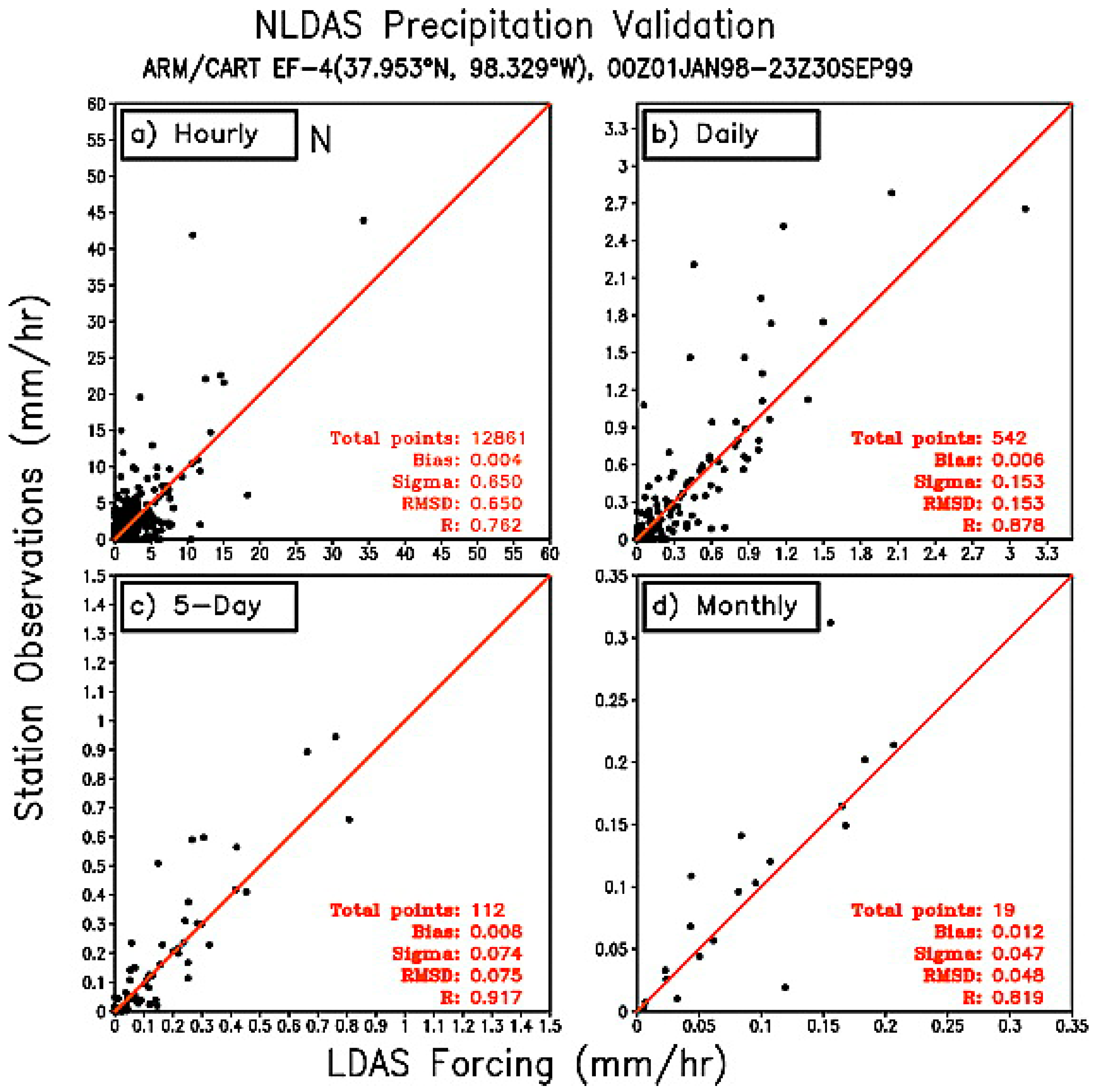
5.6. NLDAS
5.7. GLDAS
5.8. GRACE
6. Data Challenges in the ML Approach
6.1. Spatial and Temporal Resolution
6.2. Data Quality and Consistency
6.3. Regional and Climatic Representation
6.4. Downscaling of LSH
6.5. Data Accessibility
7. Benefits of High-Resolution Datasets over Traditional Methods
8. Future Directions
8.1. Focusing on Specific Hydrologic Regimes
8.2. Incorporating Human Impacts
8.3. Uncertainty Quantification
8.4. Real-Time Data Integration
8.5. Data Collection
9. Conclusions
Funding
Data Availability Statement
Conflicts of Interest
References
- Lange, H.; Sippel, S. Machine Learning Applications in Hydrology; Springer: Cham, Switzerland, 2020; pp. 233–257. [Google Scholar] [CrossRef]
- Raschka, S.; Patterson, J.; Nolet, C. Machine Learning in Python: Main Developments and Technology Trends in Data Science, Machine Learning, and Artificial Intelligence. Information 2020, 11, 193. [Google Scholar] [CrossRef]
- Xu, Y.; Liu, X.; Cao, X.; Huang, C.; Liu, E.; Qian, S.; Liu, X.; Wu, Y.; Dong, F.; Qiu, C.W.; et al. Artificial Intelligence: A Powerful Paradigm for Scientific Research. Innovation 2021, 2, 100179. [Google Scholar] [CrossRef] [PubMed]
- Zhou, L.; Pan, S.; Wang, J.; Vasilakos, A.V. Machine Learning on Big Data: Opportunities and Challenges. Neurocomputing 2017, 237, 350–361. [Google Scholar] [CrossRef]
- Kratzert, F.; Klotz, D.; Herrnegger, M.; Sampson, A.K.; Hochreiter, S.; Nearing, G.S. Toward Improved Predictions in Ungauged Basins: Exploiting the Power of Machine Learning. Water Resour. Res. 2019, 55, 11344–11354. [Google Scholar] [CrossRef]
- Arriagada, P.; Karelovic, B.; Link, O. Automatic Gap-Filling of Daily Streamflow Time Series in Data-Scarce Regions Using a Machine Learning Algorithm. J. Hydrol. 2021, 598, 126454. [Google Scholar] [CrossRef]
- Lu, D.; Konapala, G.; Painter, S.L.; Kao, S.C.; Gangrade, S. Streamflow Simulation in Data-Scarce Basins Using Bayesian and Physics-Informed Machine Learning Models. J. Hydrometeorol. 2021, 22, 1421–1438. [Google Scholar] [CrossRef]
- Yang, C.; Xu, M.; Kang, S.; Fu, C.; Hu, D. Improvement of Streamflow Simulation by Combining Physically Hydrological Model with Deep Learning Methods in Data-Scarce Glacial River Basin. J. Hydrol. 2023, 625, 129990. [Google Scholar] [CrossRef]
- Rafik, A.; Ait Brahim, Y.; Amazirh, A.; Ouarani, M.; Bargam, B.; Ouatiki, H.; Bouslihim, Y.; Bouchaou, L.; Chehbouni, A. Groundwater Level Forecasting in a Data-Scarce Region through Remote Sensing Data Downscaling, Hydrological Modeling, and Machine Learning: A Case Study from Morocco. J. Hydrol. Reg. Stud. 2023, 50, 101569. [Google Scholar] [CrossRef]
- Guzman, S.M.; Paz, J.O.; Tagert, M.L.M.; Mercer, A.E. Evaluation of Seasonally Classified Inputs for the Prediction of Daily Groundwater Levels: NARX Networks Vs Support Vector Machines. Environ. Model. Assess. 2019, 24, 223–234. [Google Scholar] [CrossRef]
- Zhu, H.; Zhou, Q. Advancing Satellite-Derived Precipitation Downscaling in Data-Sparse Area Through Deep Transfer Learning. IEEE Trans. Geosci. Remote Sens. 2024, 62, 4102513. [Google Scholar] [CrossRef]
- Mangukiya, N.K.; Sharma, A. Alternate Pathway for Regional Flood Frequency Analysis in Data-Sparse Region. J. Hydrol. 2024, 629, 130635. [Google Scholar] [CrossRef]
- Newman, A.J.; Clark, M.P.; Sampson, K.; Wood, A.; Hay, L.E.; Bock, A.; Viger, R.J.; Blodgett, D.; Brekke, L.; Arnold, J.R.; et al. Development of a Large-Sample Watershed-Scale Hydrometeorological Data Set for the Contiguous USA: Data Set Characteristics and Assessment of Regional Variability in Hydrologic Model Performance. Hydrol. Earth Syst. Sci. 2015, 19, 209–223. [Google Scholar] [CrossRef]
- Addor, N.; Newman, A.J.; Mizukami, N.; Clark, M.P. The CAMELS Data Set: Catchment Attributes and Meteorology for Large-Sample Studies. Hydrol. Earth Syst. Sci. 2017, 21, 5293–5313. [Google Scholar] [CrossRef]
- Clerc-Schwarzenbach, F.M.; Selleri, G.; Neri, M.; Toth, E.; van Meerveld, I.; Seibert, J. HESS Opinions: A Few Camels or a Whole Caravan? EGUsphere 2024, 2024, 1–29. [Google Scholar] [CrossRef]
- Kratzert, F.; Nearing, G.; Addor, N.; Erickson, T.; Gauch, M.; Gilon, O.; Gudmundsson, L.; Hassidim, A.; Klotz, D.; Nevo, S.; et al. Caravan-A Global Community Dataset for Large-Sample Hydrology. Sci. Data 2023, 10, 61. [Google Scholar] [CrossRef] [PubMed]
- Funk, C.; Peterson, P.; Landsfeld, M.; Pedreros, D.; Verdin, J.; Shukla, S.; Husak, G.; Rowland, J.; Harrison, L.; Hoell, A.; et al. The Climate Hazards Infrared Precipitation with Stations—A New Environmental Record for Monitoring Extremes. Sci. Data 2015, 2, 150066. [Google Scholar] [CrossRef] [PubMed]
- Adem, E.; Elfeki, A.; Chaabani, A.; Alwegdani, A.; Hussain, S.; Elhag, M. Impact of Satellite Precipitation Estimation Methods on the Hydrological Response: Case Study Wadi Nu’man Basin, Saudi Arabia. Theor. Appl. Climatol. 2024, 155, 3907–3925. [Google Scholar] [CrossRef]
- Wang, M.; Rezaie-Balf, M.; Naganna, S.R.; Yaseen, Z.M. Sourcing CHIRPS Precipitation Data for Streamflow Forecasting Using Intrinsic Time-Scale Decomposition Based Machine Learning Models. Hydrol. Sci. J. 2021, 66, 1437–1456. [Google Scholar] [CrossRef]
- Khan, M.A.; Stamm, J. Assessment of the Hydrological and Coupled Soft Computing Models, Based on Different Satellite Precipitation Datasets, to Simulate Streamflow and Sediment Load in a Mountainous Catchment. J. Water Clim. Change 2023, 14, 610–632. [Google Scholar] [CrossRef]
- Bhusal, A.; Parajuli, U.; Regmi, S.; Kalra, A. Application of Machine Learning and Process-Based Models for Rainfall-Runoff Simulation in DuPage River Basin, Illinois. Hydrology 2022, 9, 117. [Google Scholar] [CrossRef]
- Yeditha, P.K.; Kasi, V.; Rathinasamy, M.; Agarwal, A. Forecasting of Extreme Flood Events Using Different Satellite Precipitation Products and Wavelet-Based Machine Learning Methods. Chaos 2020, 30, 063115. [Google Scholar] [CrossRef]
- Chancay, J.E.; Espitia-Sarmiento, E.F. Improving Hourly Precipitation Estimates for Flash Flood Modeling in Data-Scarce Andean-Amazon Basins: An Integrative Framework Based on Machine Learning and Multiple Remotely Sensed Data. Remote Sens. 2021, 13, 4446. [Google Scholar] [CrossRef]
- Hayatbini, N.; Kong, B.; Hsu, K.L.; Nguyen, P.; Sorooshian, S.; Stephens, G.; Fowlkes, C.; Nemani, R.; Ganguly, S. Conditional Generative Adversarial Networks (CGANs) for near Real-Time Precipitation Estimation from Multispectral GOES-16 Satellite Imageries-PERSIANN-CGAN. Remote Sens. 2019, 11, 2193. [Google Scholar] [CrossRef]
- Tao, Y.; Hsu, K.; Ihler, A.; Gao, X.; Sorooshian, S. A Two-Stage Deep Neural Network Framework for Precipitation Estimation from Bispectral Satellite Information. J. Hydrometeorol. 2018, 19, 393–408. [Google Scholar] [CrossRef]
- Das, P.; Zhang, Z.; Ren, H. Evaluating the Accuracy of Two Satellite-Based Quantitative Precipitation Estimation Products and Their Application for Meteorological Drought Monitoring over the Lake Victoria Basin, East Africa. Geo-Spat. Inf. Sci. 2022, 25, 500–518. [Google Scholar] [CrossRef]
- Yu, C.; Hu, D.; Shao, H.; Dai, X.; Liu, G.; Wu, S. Runoff Simulation Driven by Multi-Source Satellite Data Based on Hydrological Mechanism Algorithm and Deep Learning Network. J. Hydrol. Re.g Stud. 2024, 52, 101720. [Google Scholar] [CrossRef]
- Khajehali, M.; Safavi, H.R.; Nikoo, M.R.; Fooladi, M. A Fusion-Based Framework for Daily Flood Forecasting in Multiple-Step-Ahead and near-Future under Climate Change Scenarios: A Case Study of the Kan River, Iran. In Natural Hazards; Springer: Berlin/Heidelberg, Germany, 2024. [Google Scholar] [CrossRef]
- Ayzel, G.; Kurochkina, L.; Zhuravlev, S. The Influence of Regional Hydrometric Data Incorporation on the Accuracy of Gridded Reconstruction of Monthly Runoff. Hydrol. Sci. J. 2022, 67, 2429–2440. [Google Scholar] [CrossRef]
- Wang, C.; Jiang, S.; Zheng, Y.; Han, F.; Kumar, R.; Rakovec, O.; Li, S. Distributed Hydrological Modeling With Physics-Encoded Deep Learning: A General Framework and Its Application in the Amazon. Water Resour. Res. 2024, 60, e2023WR036170. [Google Scholar] [CrossRef]
- Jiang, S.; Zheng, Y.; Solomatine, D. Improving AI System Awareness of Geoscience Knowledge: Symbiotic Integration of Physical Approaches and Deep Learning. Geophys. Res. Lett. 2020, 47, e2020GL088229. [Google Scholar] [CrossRef]
- Xu, T.; Liang, F. Machine Learning for Hydrologic Sciences: An Introductory Overview. WIREs Water 2021, 8, e1533. [Google Scholar] [CrossRef]
- Rasheed, Z.; Aravamudan, A.; Gorji Sefidmazgi, A.; Anagnostopoulos, G.C.; Nikolopoulos, E.I. Advancing Flood Warning Procedures in Ungauged Basins with Machine Learning. J. Hydrol. 2022, 609, 127736. [Google Scholar] [CrossRef]
- Zhou, F.; Chen, Y.; Liu, J. Application of a New Hybrid Deep Learning Model That Considers Temporal and Feature Dependencies in Rainfall–Runoff Simulation. Remote Sens. 2023, 15, 1395. [Google Scholar] [CrossRef]
- Ehteram, M.; Ghanbari-Adivi, E. Self-Attention (SA) Temporal Convolutional Network (SATCN)-Long Short-Term Memory Neural Network (SATCN-LSTM): An Advanced Python Code for Predicting Groundwater Level. Environ. Sci. Pollut. Res. 2023, 30, 92903–92921. [Google Scholar] [CrossRef] [PubMed]
- Arsenault, R.; Martel, J.L.; Brunet, F.; Brissette, F.; Mai, J. Continuous Streamflow Prediction in Ungauged Basins: Long Short-Term Memory Neural Networks Clearly Outperform Traditional Hydrological Models. Hydrol. Earth Syst. Sci. 2023, 27, 139–157. [Google Scholar] [CrossRef]
- Sabzipour, B.; Arsenault, R.; Troin, M.; Martel, J.L.; Brissette, F.; Brunet, F.; Mai, J. Comparing a Long Short-Term Memory (LSTM) Neural Network with a Physically-Based Hydrological Model for Streamflow Forecasting over a Canadian Catchment. J. Hydrol. 2023, 627, 130380. [Google Scholar] [CrossRef]
- Shen, C.; Lawson, K. Applications of Deep Learning in Hydrology. Deep Learning for the Earth Sciences: A Comprehensive Approach to Remote Sensing, Climate Science and Geosciences; John Wiley & Sons: Hoboken, NJ, USA, 2021; pp. 283–297. [Google Scholar] [CrossRef]
- Tripathy, K.P.; Mishra, A.K. Deep Learning in Hydrology and Water Resources Disciplines: Concepts, Methods, Applications, and Research Directions. J. Hydrol. 2024, 628, 130458. [Google Scholar] [CrossRef]
- Hegelich, S. Decision Trees and Random Forests: Machine Learning Techniques to Classify Rare Events. Eur. Policy Anal. 2016, 2, 98–120. [Google Scholar] [CrossRef]
- Ali, J.; Khan, R.; Ahmad, N.; Maqsood, I. Random Forests and Decision Trees. Int. J. Comput. Sci. Issues 2012, 9, 272. [Google Scholar]
- He, X.; Chaney, N.W.; Schleiss, M.; Sheffield, J. Spatial Downscaling of Precipitation Using Adaptable Random Forests. Water Resour. Res. 2016, 52, 8217–8237. [Google Scholar] [CrossRef]
- Liang, Z.; Tang, T.; Li, B.; Liu, T.; Wang, J.; Hu, Y. Long-Term Streamflow Forecasting Using SWAT through the Integration of the Random Forests Precipitation Generator: Case Study of Danjiangkou Reservoir. Hydrol. Res. 2018, 49, 1513–1527. [Google Scholar] [CrossRef]
- Elbeltagi, A.; Pande, C.B.; Kumar, M.; Tolche, A.D.; Singh, S.K.; Kumar, A.; Vishwakarma, D.K. Prediction of Meteorological Drought and Standardized Precipitation Index Based on the Random Forest (RF), Random Tree (RT), and Gaussian Process Regression (GPR) Models. Environ. Sci. Pollut. Res. 2023, 30, 43183–43202. [Google Scholar] [CrossRef] [PubMed]
- Saber, M.; Boulmaiz, T.; Guermoui, M.; Abdrabo, K.I.; Kantoush, S.A.; Sumi, T.; Boutaghane, H.; Hori, T.; Binh, D.V.; Nguyen, B.Q.; et al. Enhancing Flood Risk Assessment through Integration of Ensemble Learning Approaches and Physical-Based Hydrological Modeling. Geomat. Nat. Hazards Risk 2023, 14, 2203798. [Google Scholar] [CrossRef]
- Anandhi, A.; Srinivas, V.V.; Nanjundiah, R.S.; Nagesh Kumar, D. Downscaling Precipitation to River Basin in India for IPCC SRES Scenarios Using Support Vector Machine. Int. J. Climatol. 2008, 28, 401–420. [Google Scholar] [CrossRef]
- Sudheer, C.; Shrivastava, N.A.; Panigrahi, B.K.; Mathur, S. Groundwater Level Forecasting Using SVM-QPSO. In Lecture Notes in Computer Science (Including Subseries Lecture Notes in Artificial Intelligence and Lecture Notes in Bioinformatics); Springer: Berlin/Heidelberg, Germany, 2011; pp. 731–741. [Google Scholar] [CrossRef]
- Sudheer, C.; Maheswaran, R.; Panigrahi, B.K.; Mathur, S. A Hybrid SVM-PSO Model for Forecasting Monthly Streamflow. Neural. Comput. Appl. 2014, 24, 1381–1389. [Google Scholar] [CrossRef]
- Raghavendra, S.; Deka, P.C. Support Vector Machine Applications in the Field of Hydrology: A Review. Appl. Soft Comput. 2014, 19, 372–386. [Google Scholar] [CrossRef]
- Pappu, V.; Pardalos, P.M. High-Dimensional Data Classification. Springer Optim. Its Appl. 2014, 92, 119–150. [Google Scholar] [CrossRef]
- Xu XUHUAN, H.; Caramanis, C.; Mannor, S.; Smola, A. Robustness and Regularization of Support Vector Machines. J. Mach. Learn. Res. 2009, 10, 1485–1510. [Google Scholar]
- Li, H.X.; Yang, J.L.; Zhang, G.; Fan, B. Probabilistic Support Vector Machines for Classification of Noise Affected Data. Inf. Sci. 2013, 221, 60–71. [Google Scholar] [CrossRef]
- Tan, C.O.; Beklioglu, M. Modeling Complex Nonlinear Responses of Shallow Lakes to Fish and Hydrology Using Artificial Neural Networks. Ecol. Model. 2006, 196, 183–194. [Google Scholar] [CrossRef]
- Kouadri, S.; Pande, C.B.; Panneerselvam, B.; Moharir, K.N.; Elbeltagi, A. Prediction of Irrigation Groundwater Quality Parameters Using ANN, LSTM, and MLR Models. Environ. Sci. Pollut. Res. 2022, 29, 21067–21091. [Google Scholar] [CrossRef]
- Wu, W.; Dandy, G.C.; Maier, H.R. Protocol for Developing ANN Models and Its Application to the Assessment of the Quality of the ANN Model Development Process in Drinking Water Quality Modelling. Environ. Model. Softw. 2014, 54, 108–127. [Google Scholar] [CrossRef]
- Chang, L.C.; Amin, M.Z.M.; Yang, S.N.; Chang, F.J. Building ANN-Based Regional Multi-Step-Ahead Flood Inundation Forecast Models. Water 2018, 10, 1283. [Google Scholar] [CrossRef]
- Nourani, V.; Komasi, M.; Mano, A. A Multivariate ANN-Wavelet Approach for Rainfall-Runoff Modeling. Water Resour. Manag. 2009, 23, 2877–2894. [Google Scholar] [CrossRef]
- Carabantes, M. Black-Box Artificial Intelligence: An Epistemological and Critical Analysis. AI Soc. 2020, 35, 309–317. [Google Scholar] [CrossRef]
- Khalaf Jabbar Rafiqul Zaman Khan, H.D. Methods to Avoid Over-Fitting and under-Fitting in Supervised Machine Learning (Comparative Study). Comput. Sci. Commun. Instrum. Devices 2015, 70, 978–981. [Google Scholar]
- Piotrowski, A.P.; Napiorkowski, J.J. A Comparison of Methods to Avoid Overfitting in Neural Networks Training in the Case of Catchment Runoff Modelling. J. Hydrol. 2013, 476, 97–111. [Google Scholar] [CrossRef]
- Pham, Q.B.; Kumar, M.; Di Nunno, F.; Elbeltagi, A.; Granata, F.; Islam, A.R.M.T.; Talukdar, S.; Nguyen, X.C.; Ahmed, A.N.; Anh, D.T. Groundwater Level Prediction Using Machine Learning Algorithms in a Drought-Prone Area. Neural. Comput. Appl. 2022, 34, 10751–10773. [Google Scholar] [CrossRef]
- Ibrahem Ahmed Osman, A.; Najah Ahmed, A.; Chow, M.F.; Feng Huang, Y.; El-Shafie, A. Extreme Gradient Boosting (Xgboost) Model to Predict the Groundwater Levels in Selangor Malaysia. Ain Shams Eng. J. 2021, 12, 1545–1556. [Google Scholar] [CrossRef]
- Chen, L.; Xing, M.; He, B.; Wang, J.; Shang, J.; Huang, X.; Xu, M. Estimating Soil Moisture over Winter Wheat Fields during Growing Season Using Machine-Learning Methods. IEEE J. Sel. Top. Appl. Earth Obs. Remote Sens. 2021, 14, 3706–3718. [Google Scholar] [CrossRef]
- Xu, K.; Han, Z.; Xu, H.; Bin, L. Rapid Prediction Model for Urban Floods Based on a Light Gradient Boosting Machine Approach and Hydrological–Hydraulic Model. Int. J. Disaster Risk Sci. 2023, 14, 79–97. [Google Scholar] [CrossRef]
- Natekin, A.; Knoll, A. Gradient Boosting Machines, a Tutorial. Front. Neurorobot. 2013, 7, 63623. [Google Scholar] [CrossRef] [PubMed]
- Tao, H.; Awadh, S.M.; Salih, S.Q.; Shafik, S.S.; Yaseen, Z.M. Integration of Extreme Gradient Boosting Feature Selection Approach with Machine Learning Models: Application of Weather Relative Humidity Prediction. Neural. Comput. Appl. 2022, 34, 515–533. [Google Scholar] [CrossRef]
- Wang, Y.; Fang, Z.; Hong, H.; Peng, L. Flood Susceptibility Mapping Using Convolutional Neural Network Frameworks. J. Hydrol. 2020, 582, 124482. [Google Scholar] [CrossRef]
- Sadeghi, M.; Asanjan, A.A.; Faridzad, M.; Nguyen, P.H.U.; Hsu, K.; Sorooshian, S.; Braithwaite, D.A.N. PERSIANN-CNN: Precipitation Estimation from Remotely Sensed Information Using Artificial Neural Networks–Convolutional Neural Networks. J. Hydrometeorol. 2019, 20, 2273–2289. [Google Scholar] [CrossRef]
- Yang, F.; Feng, T.; Xu, G.; Chen, Y. Applied Method for Water-Body Segmentation Based on Mask R-CNN. J. Appl. Remote Sens. 2020, 14, 1. [Google Scholar] [CrossRef]
- Naganna, S.R.; Marulasiddappa, S.B.; Balreddy, M.S.; Yaseen, Z.M. Daily Scale Streamflow Forecasting in Multiple Stream Orders of Cauvery River, India: Application of Advanced Ensemble and Deep Learning Models. J. Hydrol. 2023, 626, 130320. [Google Scholar] [CrossRef]
- Yamashita, R.; Nishio, M.; Do, R.K.G.; Togashi, K. Convolutional Neural Networks: An Overview and Application in Radiology. Insights Imaging 2018, 9, 611–629. [Google Scholar] [CrossRef] [PubMed]
- Alzubaidi, L.; Zhang, J.; Humaidi, A.J.; Al-Dujaili, A.; Duan, Y.; Al-Shamma, O.; Santamaría, J.; Fadhel, M.A.; Al-Amidie, M.; Farhan, L. Review of Deep Learning: Concepts, CNN Architectures, Challenges, Applications, Future Directions. J. Big Data 2021, 8, 53. [Google Scholar] [CrossRef] [PubMed]
- Zhou, H.; Zhang, S.; Peng, J.; Zhang, S.; Li, J.; Xiong, H.; Zhang, W. Informer: Beyond Efficient Transformer for Long Sequence Time-Series Forecasting. Proc. AAAI Conf. Artif. Intell. 2021, 35, 11106–11115. [Google Scholar] [CrossRef]
- Castangia, M.; Grajales, L.M.M.; Aliberti, A.; Rossi, C.; Macii, A.; Macii, E.; Patti, E. Transformer Neural Networks for Interpretable Flood Forecasting. Environ. Model. Softw. 2023, 160, 105581. [Google Scholar] [CrossRef]
- Liu, C.; Liu, D.; Mu, L. Improved Transformer Model for Enhanced Monthly Streamflow Predictions of the Yangtze River. IEEE Access 2022, 10, 58240–58253. [Google Scholar] [CrossRef]
- Ghobadi, F.; Kang, D. Improving Long-Term Streamflow Prediction in a Poorly Gauged Basin Using Geo-Spatiotemporal Mesoscale Data and Attention-Based Deep Learning: A Comparative Study. J. Hydrol. 2022, 615, 128608. [Google Scholar] [CrossRef]
- Yin, L.; Wang, L.; Keim, B.D.; Konsoer, K.; Yin, Z.; Liu, M.; Zheng, W. Spatial and Wavelet Analysis of Precipitation and River Discharge during Operation of the Three Gorges Dam, China. Ecol. Indic. 2023, 154, 110837. [Google Scholar] [CrossRef]
- Zhang, K.; Li, Y.; Yu, Z.; Yang, T.; Xu, J.; Chao, L.; Ni, J.; Wang, L.; Gao, Y.; Hu, Y.; et al. Xin’anjiang Nested Experimental Watershed (XAJ-NEW) for Understanding Multiscale Water Cycle: Scientific Objectives and Experimental Design. Engineering 2022, 18, 207–217. [Google Scholar] [CrossRef]
- Global Runoff Data Centre (GRDC)-Dataset-Waterdata. Available online: https://wbwaterdata.org/dataset/global-runoff-data-centre-grdc (accessed on 17 May 2024).
- Nguyen, P.; Shearer, E.J.; Tran, H.; Ombadi, M.; Hayatbini, N.; Palacios, T.; Huynh, P.; Braithwaite, D.; Updegraff, G.; Hsu, K.; et al. The CHRS Data Portal, an Easily Accessible Public Repository for PERSIANN Global Satellite Precipitation Data. Sci. Data 2019, 6, 180296. [Google Scholar] [CrossRef] [PubMed]
- Ashouri, H.; Hsu, K.L.; Sorooshian, S.; Braithwaite, D.K.; Knapp, K.R.; Cecil, L.D.; Nelson, B.R.; Prat, O.P. PERSIANN-CDR: Daily Precipitation Climate Data Record from Multisatellite Observations for Hydrological and Climate Studies. Bull. Am. Meteorol. Soc. 2015, 96, 69–83. [Google Scholar] [CrossRef]
- Sadeghi, M.; Nguyen, P.; Naeini, M.R.; Hsu, K.; Braithwaite, D.; Sorooshian, S. PERSIANN-CCS-CDR, a 3-Hourly 0.04° Global Precipitation Climate Data Record for Heavy Precipitation Studies. Sci. Data 2021, 8, 157. [Google Scholar] [CrossRef] [PubMed]
- Ma, K.; Feng, D.; Lawson, K.; Tsai, W.P.; Liang, C.; Huang, X.; Sharma, A.; Shen, C. Transferring Hydrologic Data Across Continents–Leveraging Data-Rich Regions to Improve Hydrologic Prediction in Data-Sparse Regions. Water Resour. Res. 2021, 57, e2020WR028600. [Google Scholar] [CrossRef]
- Ouyang, W.; Lawson, K.; Feng, D.; Ye, L.; Zhang, C.; Shen, C. Continental-Scale Streamflow Modeling of Basins with Reservoirs: Towards a Coherent Deep-Learning-Based Strategy. J. Hydrol. 2021, 599, 126455. [Google Scholar] [CrossRef]
- Kratzert, R.; Klotz, F.; Brenner, D.; Schulz, C.; Herrnegger, K. Rainfall-Runoff Modelling Using Long Short-Term Memory (LSTM) Networks. Hydrol. Earth Syst. Sci. 2018, 22, 2775–2784. [Google Scholar] [CrossRef]
- Khand, K.; Senay, G.B. Evaluation of Streamflow Predictions from LSTM Models in Water- and Energy-Limited Regions in the United States. Mach. Learn. Appl. 2024, 16, 100551. [Google Scholar] [CrossRef]
- Xu, L.; Shi, P.; Wu, H.; Qu, S.; Li, Q.; Sun, Y.; Yang, X.; Jiang, P.; Qiu, C. Investigating the Potential of EMA-Embedded Feature Selection Method for ESVR and LSTM to Enhance the Robustness of Monthly Streamflow Forecasting from Local Meteorological Information. J. Hydrol. 2024, 636, 131230. [Google Scholar] [CrossRef]
- Duan, S.; Ullrich, P.; Shu, L. Using Convolutional Neural Networks for Streamflow Projection in California. Front. Water 2020, 2, 28. [Google Scholar] [CrossRef]
- Ren, K.; Fang, W.; Qu, J.; Zhang, X.; Shi, X. Comparison of Eight Filter-Based Feature Selection Methods for Monthly Streamflow Forecasting–Three Case Studies on CAMELS Data Sets. J. Hydrol. 2020, 586, 124897. [Google Scholar] [CrossRef]
- Feng, D.; Fang, K.; Shen, C. Enhancing Streamflow Forecast and Extracting Insights Using Long-Short Term Memory Networks With Data Integration at Continental Scales. Water Resour. Res. 2020, 56, e2019WR026793. [Google Scholar] [CrossRef]
- Sadler, J.M.; Appling, A.P.; Read, J.S.; Oliver, S.K.; Jia, X.; Zwart, J.A.; Kumar, V. Multi-Task Deep Learning of Daily Streamflow and Water Temperature. Water Resour. Res. 2022, 58, e2021WR030138. [Google Scholar] [CrossRef]
- Wi, S.; Steinschneider, S. Assessing the Physical Realism of Deep Learning Hydrologic Model Projections Under Climate Change. Water Resour. Res. 2022, 58, e2022WR032123. [Google Scholar] [CrossRef]
- Tyralis, H.; Papacharalampous, G.; Langousis, A. Super Ensemble Learning for Daily Streamflow Forecasting: Large-Scale Demonstration and Comparison with Multiple Machine Learning Algorithms. Neural. Comput. Appl. 2021, 33, 3053–3068. [Google Scholar] [CrossRef]
- Frame, J.M.; Kratzert, F.; Raney, A.; Rahman, M.; Salas, F.R.; Nearing, G.S. Post-Processing the National Water Model with Long Short-Term Memory Networks for Streamflow Predictions and Model Diagnostics. JAWRA J. Am. Water Resour. Assoc. 2021, 57, 885–905. [Google Scholar] [CrossRef]
- Feng, D.; Liu, J.; Lawson, K.; Shen, C. Differentiable, Learnable, Regionalized Process-Based Models With Multiphysical Outputs Can Approach State-Of-The-Art Hydrologic Prediction Accuracy. Water Resour. Res. 2022, 58, e2022WR032404. [Google Scholar] [CrossRef]
- Kratzert, F.; Klotz, D.; Hochreiter, S.; Nearing, G.S. A Note on Leveraging Synergy in Multiple Meteorological Data Sets with Deep Learning for Rainfall-Runoff Modeling. Hydrol. Earth Syst. Sci. 2021, 25, 2685–2703. [Google Scholar] [CrossRef]
- Xie, K.; Liu, P.; Zhang, J.; Han, D.; Wang, G.; Shen, C. Physics-Guided Deep Learning for Rainfall-Runoff Modeling by Considering Extreme Events and Monotonic Relationships. J. Hydrol. 2021, 603, 127043. [Google Scholar] [CrossRef]
- Yin, H.; Guo, Z.; Zhang, X.; Chen, J.; Zhang, Y. RR-Former: Rainfall-Runoff Modeling Based on Transformer. J. Hydrol. 2022, 609, 127781. [Google Scholar] [CrossRef]
- Herath, H.M.V.V.; Chadalawada, J.; Babovic, V. Hydrologically Informed Machine Learning for Rainfall-Runoff Modelling: Towards Distributed Modelling. Hydrol. Earth Syst. Sci. 2021, 25, 4373–4401. [Google Scholar] [CrossRef]
- Yin, W.; Fan, Z.; Tangdamrongsub, N.; Hu, L.; Zhang, M. Comparison of Physical and Data-Driven Models to Forecast Groundwater Level Changes with the Inclusion of GRACE–A Case Study over the State of Victoria, Australia. J. Hydrol. 2021, 602, 126735. [Google Scholar] [CrossRef]
- Jin, J.; Zhang, Y.; Hao, Z.; Xia, R.; Yang, W.; Yin, H.; Zhang, X. Benchmarking Data-Driven Rainfall-Runoff Modeling across 54 Catchments in the Yellow River Basin: Overfitting, Calibration Length, Dry Frequency. J. Hydrol. Reg. Stud. 2022, 42, 101119. [Google Scholar] [CrossRef]
- Klotz, D.; Kratzert, F.; Gauch, M.; Keefe Sampson, A.; Brandstetter, J.; Klambauer, G.; Hochreiter, S.; Nearing, G. Uncertainty Estimation with Deep Learning for Rainfall-Runoff Modeling. Hydrol. Earth Syst. Sci. 2022, 26, 1673–1693. [Google Scholar] [CrossRef]
- Yin, H.; Zhang, X.; Wang, F.; Zhang, Y.; Xia, R.; Jin, J. Rainfall-Runoff Modeling Using LSTM-Based Multi-State-Vector Sequence-to-Sequence Model. J. Hydrol. 2021, 598, 126378. [Google Scholar] [CrossRef]
- Stein, L.; Clark, M.P.; Knoben, W.J.M.; Pianosi, F.; Woods, R.A. How Do Climate and Catchment Attributes Influence Flood Generating Processes? A Large-Sample Study for 671 Catchments Across the Contiguous USA. Water Resour. Res. 2021, 57, e2020WR028300. [Google Scholar] [CrossRef]
- Jarajapu, D.C.; Rathinasamy, M.; Agarwal, A.; Bronstert, A. Design Flood Estimation Using Extreme Gradient Boosting-Based on Bayesian Optimization. J. Hydrol. 2022, 613, 128341. [Google Scholar] [CrossRef]
- Liu, L.; Liu, X.; Bai, P.; Liang, K.; Liu, C. Comparison of Flood Simulation Capabilities of a Hydrologic Model and a Machine Learning Model. Int. J. Climatol. 2023, 43, 123–133. [Google Scholar] [CrossRef]
- Cai, H.; Shi, H.; Liu, S.; Babovic, V. Impacts of Regional Characteristics on Improving the Accuracy of Groundwater Level Prediction Using Machine Learning: The Case of Central Eastern Continental United States. J. Hydrol. Reg. Stud. 2021, 37. [Google Scholar] [CrossRef]
- Cai, H.; Liu, S.; Shi, H.; Zhou, Z.; Jiang, S.; Babovic, V. Toward Improved Lumped Groundwater Level Predictions at Catchment Scale: Mutual Integration of Water Balance Mechanism and Deep Learning Method. J. Hydrol. 2022, 613, 128495. [Google Scholar] [CrossRef]
- Ghosh, R.; Renganathan, A.; Tayal, K.; Li, X.; Khandelwal, A.; Jia, X.; Duffy, C.; Nieber, J.; Kumar, V. Robust Inverse Framework Using Knowledge-Guided Self-Supervised Learning: An Application to Hydrology. In Proceedings of the ACM SIGKDD International Conference on Knowledge Discovery and Data Mining, Washington, DC, USA, 14 August 2022; Association for Computing Machinery: New York, NY, USA, 2022; pp. 465–474. [Google Scholar]
- Abbas, A.; Boithias, L.; Pachepsky, Y.; Kim, K.; Chun, J.A.; Cho, K.H. AI4Water v1.0: An Open-Source Python Package for Modeling Hydrological Time Series Using Data-Driven Methods. Geosci. Model. Dev. 2022, 15, 3021–3039. [Google Scholar] [CrossRef]
- Feng, D.; Beck, H.; Lawson, K.; Shen, C. The Suitability of Differentiable, Physics-Informed Machine Learning Hydrologic Models for Ungauged Regions and Climate Change Impact Assessment. Hydrol. Earth Syst. Sci. 2023, 27, 2357–2373. [Google Scholar] [CrossRef]
- Frame, J.M.; Kratzert, F.; Gupta, H.V.; Ullrich, P.; Nearing, G.S. On Strictly Enforced Mass Conservation Constraints for Modelling the Rainfall-Runoff Process. Hydrol. Process. 2023, 37, e14847. [Google Scholar] [CrossRef]
- Tsai, W.P.; Feng, D.; Pan, M.; Beck, H.; Lawson, K.; Yang, Y.; Liu, J.; Shen, C. From Calibration to Parameter Learning: Harnessing the Scaling Effects of Big Data in Geoscientific Modeling. Nat. Commun. 2021, 12, 5988. [Google Scholar] [CrossRef] [PubMed]
- Papacharalampous, G.; Tyralis, H.; Langousis, A.; Jayawardena, A.W.; Sivakumar, B.; Mamassis, N.; Montanari, A.; Koutsoyiannis, D. Probabilistic Hydrological Post-Processing at Scale: Why and How to Apply Machine-Learning Quantile Regression Algorithms. Water 2019, 11, 2126. [Google Scholar] [CrossRef]
- Tyralis, H.; Papacharalampous, G.; Tantanee, S. How to Explain and Predict the Shape Parameter of the Generalized Extreme Value Distribution of Streamflow Extremes Using a Big Dataset. J. Hydrol. 2019, 574, 628–645. [Google Scholar] [CrossRef]
- Li, B.; Sun, T.; Tian, F.; Ni, G. Enhancing Process-Based Hydrological Models with Embedded Neural Networks: A Hybrid Approach. J. Hydrol. 2023, 625, 130107. [Google Scholar] [CrossRef]
- Han, S.; Slater, L.; Wilby, R.; Faulkner, D. Contribution of Urbanisation to Non-Stationary River Flow in the UK. J. Hydrol. 2022, 613, 128417. [Google Scholar] [CrossRef]
- Slater, L.J.; Arnal, L.; Boucher, M.A.; Chang, A.Y.Y.; Moulds, S.; Murphy, C.; Nearing, G.; Shalev, G.; Shen, C.; Speight, L.; et al. Hybrid Forecasting: Blending Climate Predictions with AI Models. Hydrol. Earth Syst. Sci. 2023, 27, 1865–1889. [Google Scholar] [CrossRef]
- Slater, L.; Coxon, G.; Brunner, M.; McMillan, H.; Yu, L.; Zheng, Y.; Khouakhi, A.; Moulds, S.; Berghuijs, W. Spatial Sensitivity of River Flooding to Changes in Climate and Land Cover Through Explainable AI. Earths Future 2024, 12, e2023EF004035. [Google Scholar] [CrossRef]
- De la Fuente, L.A.; Gupta, H.V.; Condon, L.E. Toward a Multi-Representational Approach to Prediction and Understanding, in Support of Discovery in Hydrology. Water Resour. Res. 2023, 59, e2021WR031548. [Google Scholar] [CrossRef]
- Taheri, P.; Taheri, S.; Taheri, M.; Taheri, G. A Novel 24-Hour Deep Neural Network Based Streamflow Forecasting Method in Data-Scarce Regions. In Proceedings of the 2023 13th Smart Grid Conference (SGC), Tehran, Iran, 5–6 December 2023; Institute of Electrical and Electronics Engineers Inc.: Piscataway, NJ, USA, 2023. [Google Scholar]
- Vega-Briones, J.; de Jong, S.; Galleguillos, M.; Wanders, N. Identifying Driving Processes of Drought Recovery in the Southern Andes Natural Catchments. J. Hydrol. Reg. Stud. 2023, 47, 101369. [Google Scholar] [CrossRef]
- Quiñones, M.P.; Zortea, M.; Martins, L.S.A. Fast-Slow Streamflow Model Using Mass-Conserving LSTM. arXiv 2021, arXiv:2107.06057. [Google Scholar]
- Kapoor, A.; Pathiraja, S.; Marshall, L.; Chandra, R. DeepGR4J: A Deep Learning Hybridization Approach for Conceptual Rainfall-Runoff Modelling. Environ. Model. Softw. 2023, 169, 105831. [Google Scholar] [CrossRef]
- Althoff, D.; Destouni, G. Global Patterns in Water Flux Partitioning: Irrigated and Rainfed Agriculture Drives Asymmetrical Flux to Vegetation over Runoff. One Earth 2023, 6, 1246–1257. [Google Scholar] [CrossRef]
- Yin, H.; Wang, F.; Zhang, X.; Zhang, Y.; Chen, J.; Xia, R.; Jin, J. Rainfall-Runoff Modeling Using Long Short-Term Memory Based Step-Sequence Framework. J. Hydrol. 2022, 610, 127901. [Google Scholar] [CrossRef]
- Koya, S.R.; Roy, T. Temporal Fusion Transformers for Streamflow Prediction: Value of Combining Attention with Recurrence. J. Hydrol. 2024, 637, 131301. [Google Scholar] [CrossRef]
- Bouri, I.; Lahariya, M.; Nivron, O.; Julia, E.P.; Backes, D.; Bilinski, P.; Schumann, G. ML Framework for Global River Flood Predictions Based on the Caravan Dataset. arXiv 2022, arXiv:2212.00719. [Google Scholar]
- Lima, M.; Deck, K.; Dunbar, O.R.A.; Schneider, T. Toward Routing River Water in Land Surface Models with Recurrent Neural Networks. arXiv 2024, arXiv:2404.14212. [Google Scholar]
- Yang, Y.; Chui, T.F.M. Profiling and Pairing Catchments and Hydrological Models With Latent Factor Model. Water Resour. Res. 2023, 59, e2022WR033684. [Google Scholar] [CrossRef]
- Renganathan, A.; Ghosh, R.; Khandelwal, A.; Kumar, V. Task Aware Modulation Using Representation Learning: An Approach for Few Shot Learning in Heterogeneous Systems. arXiv 2023, arXiv:2310.04727. [Google Scholar]
- Fischer, S.; Schumann, A.; Schumann, A.H. Dominant Flood Types in Europe and Their Role in Flood Statistics Dominant Flood Types in Europe and Their Role in Flood Statistics. Authorea 2024, Preprint. [Google Scholar] [CrossRef]
- Nearing, G.; Cohen, D.; Dube, V.; Gauch, M.; Gilon, O.; Harrigan, S.; Hassidim, A.; Klotz, D.; Kratzert, F.; Metzger, A.; et al. Global Prediction of Extreme Floods in Ungauged Watersheds. Nature 2024, 627, 559–563. [Google Scholar] [CrossRef] [PubMed]
- Murray, A.M.; Jørgensen, G.H.; Godiksen, P.N.; Anthonj, J.; Madsen, H. DHI-GHM: Real-Time and Forecasted Hydrology for the Entire Planet. J. Hydrol. 2023, 620, 129431. [Google Scholar] [CrossRef]
- Lin, Y.; Wang, D.; Jiang, T.; Kang, A. Assessing Objective Functions in Streamflow Prediction Model Training Based on the Naïve Method. Water 2024, 16, 777. [Google Scholar] [CrossRef]
- Constenla-Villoslada, S.; Liu, Y.; Wen, J.; Sun, Y.; Chonabayashi, S. Large-Scale Land Restoration Improved Drought Resilience in Ethiopia’s Degraded Watersheds. Nat. Sustain. 2022, 5, 488–497. [Google Scholar] [CrossRef]
- Zambrano, F.; Vrieling, A.; Nelson, A.; Meroni, M.; Tadesse, T. Prediction of Drought-Induced Reduction of Agricultural Productivity in Chile from MODIS, Rainfall Estimates, and Climate Oscillation Indices. Remote Sens. Environ. 2018, 219, 15–30. [Google Scholar] [CrossRef]
- Jalayer, S.; Sharifi, A.; Abbasi-Moghadam, D.; Tariq, A.; Qin, S. Assessment of Spatiotemporal Characteristic of Droughts Using In Situ and Remote Sensing-Based Drought Indices. IEEE J. Sel. Top. Appl. Earth Obs. Remote Sens. 2023, 16, 1483–1502. [Google Scholar] [CrossRef]
- Sulugodu, B.; Deka, P.C. Evaluating the Performance of CHIRPS Satellite Rainfall Data for Streamflow Forecasting. Water Resour. Manag. 2019, 33, 3913–3927. [Google Scholar] [CrossRef]
- Riazi, M.; Khosravi, K.; Shahedi, K.; Ahmad, S.; Jun, C.; Bateni, S.M.; Kazakis, N. Enhancing Flood Susceptibility Modeling Using Multi-Temporal SAR Images, CHIRPS Data, and Hybrid Machine Learning Algorithms. Sci. Total Environ. 2023, 871, 162066. [Google Scholar] [CrossRef] [PubMed]
- Iamampai, S.; Talaluxmana, Y.; Kanasut, J.; Rangsiwanichpong, P. Enhancing Rainfall-Runoff Model Accuracy with Machine Learning Models by Using Soil Water Index to Reflect Runoff Characteristics. Water Sci. Technol. 2024, 89, 368–381. [Google Scholar] [CrossRef]
- Nakhaei, M.; Mohebbi Tafreshi, A.; Saadi, T. An Evaluation of Satellite Precipitation Downscaling Models Using Machine Learning Algorithms in Hashtgerd Plain, Iran. Model. Earth Syst. Environ. 2023, 9, 2829–2843. [Google Scholar] [CrossRef]
- Read, J.S.; Jia, X.; Willard, J.; Appling, A.P.; Zwart, J.A.; Oliver, S.K.; Karpatne, A.; Hansen, G.J.A.; Hanson, P.C.; Watkins, W.; et al. Process-Guided Deep Learning Predictions of Lake Water Temperature. Water Resour. Res. 2019, 55, 9173–9190. [Google Scholar] [CrossRef]
- Han, H.; Morrison, R.R. Data-Driven Approaches for Runoff Prediction Using Distributed Data. Stoch. Environ. Res. Risk Assess. 2021, 36, 2153–2171. [Google Scholar] [CrossRef]
- Alipour, A.; Ahmadalipour, A.; Abbaszadeh, P.; Moradkhani, H. Leveraging Machine Learning for Predicting Flash Flood Damage in the Southeast US. Environ. Res. Lett. 2020, 15, 024011. [Google Scholar] [CrossRef]
- Lee, J.; Park, S.; Im, J.; Yoo, C.; Seo, E. Improved Soil Moisture Estimation: Synergistic Use of Satellite Observations and Land Surface Models over CONUS Based on Machine Learning. J. Hydrol. 2022, 609, 127749. [Google Scholar] [CrossRef]
- Fang, B.; Lakshmi, V.; Bindlish, R.; Jackson, T.J. AMSR2 Soil Moisture Downscaling Using Temperature and Vegetation Data. Remote Sens. 2018, 10, 1575. [Google Scholar] [CrossRef]
- Wang, F.; Chen, Y.; Li, Z.; Fang, G.; Li, Y.; Wang, X.; Zhang, X.; Kayumba, P.M. Developing a Long Short-Term Memory (LSTM)-Based Model for Reconstructing Terrestrial Water Storage Variations from 1982 to 2016 in the Tarim River Basin, Northwest China. Remote Sens. 2021, 13, 889. [Google Scholar] [CrossRef]
- Chen, Z.; Zeng, Y.; Shen, G.; Xiao, C.; Xu, L.; Chen, N. Spatiotemporal Characteristics and Estimates of Extreme Precipitation in the Yangtze River Basin Using GLDAS Data. Int. J. Climatol. 2021, 41, E1812–E1830. [Google Scholar] [CrossRef]
- Greifeneder, F.; Notarnicola, C.; Wagner, W. A Machine Learning-Based Approach for Surface Soil Moisture Estimations with Google Earth Engine. Remote Sens. 2021, 13, 2099. [Google Scholar] [CrossRef]
- Li, C.; Yang, H.; Yang, W.; Liu, Z.; Jia, Y.; Li, S.; Yang, D. Error Characterization of Global Land Evapotranspiration Products: Collocation-Based Approach. J. Hydrol. 2022, 612, 128102. [Google Scholar] [CrossRef]
- Zhang, G.; Zheng, W.; Yin, W.; Lei, W. Improving the Resolution and Accuracy of Groundwater Level Anomalies Using the Machine Learning-Based Fusion Model in the North China Plain. Sensors 2020, 21, 46. [Google Scholar] [CrossRef]
- Seyoum, W.M.; Kwon, D.; Milewski, A.M. Downscaling GRACE TWSA Data into High-Resolution Groundwater Level Anomaly Using Machine Learning-Based Models in a Glacial Aquifer System. Remote Sens. 2019, 11, 824. [Google Scholar] [CrossRef]
- Agarwal, V.; Akyilmaz, O.; Shum, C.K.; Feng, W.; Yang, T.Y.; Forootan, E.; Syed, T.H.; Haritashya, U.K.; Uz, M. Machine Learning Based Downscaling of GRACE-Estimated Groundwater in Central Valley, California. Sci. Total Environ. 2023, 865, 161138. [Google Scholar] [CrossRef] [PubMed]
- Malakar, P.; Mukherjee, A.; Bhanja, S.N.; Ray, R.K.; Sarkar, S.; Zahid, A. Machine-Learning-Based Regional-Scale Groundwater Level Prediction Using GRACE. Hydrogeol. J. 2021, 29, 1027–1042. [Google Scholar] [CrossRef]
- Ali, S.; Liu, D.; Fu, Q.; Cheema, M.J.M.; Pal, S.C.; Arshad, A.; Pham, Q.B.; Zhang, L. Constructing High-Resolution Groundwater Drought at Spatio-Temporal Scale Using GRACE Satellite Data Based on Machine Learning in the Indus Basin. J. Hydrol. 2022, 612, 128295. [Google Scholar] [CrossRef]
- Liu, D.; Mishra, A.K.; Yu, Z.; Lü, H.; Li, Y. Support Vector Machine and Data Assimilation Framework for Groundwater Level Forecasting Using GRACE Satellite Data. J. Hydrol. 2021, 603, 126929. [Google Scholar] [CrossRef]
- Sun, A.Y.; Scanlon, B.R.; Save, H.; Rateb, A. Reconstruction of GRACE Total Water Storage Through Automated Machine Learning. Water Resour. Res. 2021, 57, e2020WR028666. [Google Scholar] [CrossRef]
- Yin, W.; Zhang, G.; Liu, F.; Zhang, D.; Zhang, X.; Chen, S. Improving the Spatial Resolution of GRACE-Based Groundwater Storage Estimates Using a Machine Learning Algorithm and Hydrological Model. Hydrogeol. J. 2022, 30, 947–963. [Google Scholar] [CrossRef]
- Senay, G.B.; Velpuri, N.M.; Bohms, S.; Demissie, Y.; Gebremichael, M. Understanding the Hydrologic Sources and Sinks in the Nile Basin Using Multisource Climate and Remote Sensing Data Sets. Water Resour. Res. 2014, 50, 8625–8650. [Google Scholar] [CrossRef]
- Wang, J.; Gao, H.; Liu, M.; Ding, Y.; Wang, Y.; Zhao, F.; Xia, J. Parameter Regionalization of the FLEX-Global Hydrological Model. Sci. China Earth Sci. 2021, 64, 571–588. [Google Scholar] [CrossRef]
- Ngoma, H.; Wen, W.; Ayugi, B.; Babaousmail, H.; Karim, R.; Ongoma, V. Evaluation of Precipitation Simulations in CMIP6 Models over Uganda. Int. J. Climatol. 2021, 41, 4743–4768. [Google Scholar] [CrossRef]
- Zhang, Y.; Ye, A.; Analui, B.; Nguyen, P.; Sorooshian, S.; Hsu, K.; Wang, Y. Comparing Quantile Regression Forest and Mixture Density Long Short-Term Memory Models for Probabilistic Post-Processing of Satellite Precipitation-Driven Streamflow Simulations. Hydrol. Earth Syst. Sci. 2023, 27, 4529–4550. [Google Scholar] [CrossRef]
- Neeti, N.; Arun Murali, C.M.; Chowdary, V.M.; Rao, N.H.; Kesarwani, M. Integrated Meteorological Drought Monitoring Framework Using Multi-Sensor and Multi-Temporal Earth Observation Datasets and Machine Learning Algorithms: A Case Study of Central India. J. Hydrol. 2021, 601, 126638. [Google Scholar] [CrossRef]
- Kolluru, V.; Kolluru, S.; Wagle, N.; Dev, T. Secondary Precipitation Estimate Merging Using Machine Learning: Development and Evaluation over Krishna River Basin, India. Remote Sens. 2020, 12, 3013. [Google Scholar] [CrossRef]
- Alquraish, M.M.; Khadr, M. Remote-Sensing-Based Streamflow Forecasting Using Artificial Neural Network and Support Vector Machine Models. Remote Sens. 2021, 13, 4147. [Google Scholar] [CrossRef]
- Bair, E.H.; Calfa, A.A.; Rittger, K.; Dozier, J. Using Machine Learning for Real-Time Estimates of Snow Water Equivalent in the Watersheds of Afghanistan. Cryosphere 2018, 12, 1579–1594. [Google Scholar] [CrossRef]
- Rasiya Koya, S.; Kar, K.K.; Srivastava, S.; Tadesse, T.; Svoboda, M.; Roy, T. An Autoencoder-Based Snow Drought Index. Sci. Rep. 2023, 13, 20664. [Google Scholar] [CrossRef]
- Gavahi, K.; Abbaszadeh, P.; Moradkhani, H. How Does Precipitation Data Influence the Land Surface Data Assimilation for Drought Monitoring? Sci. Total Environ. 2022, 831, 154916. [Google Scholar] [CrossRef] [PubMed]
- Lee, W.J.; Lee, E.H. Runoff Prediction Based on the Discharge of Pump Stations in an Urban Stream Using a Modified Multi-Layer Perceptron Combined with Meta-Heuristic Optimization. Water 2022, 14, 99. [Google Scholar] [CrossRef]
- Xu, T.; Guo, Z.; Xia, Y.; Ferreira, V.G.; Liu, S.; Wang, K.; Yao, Y.; Zhang, X.; Zhao, C. Evaluation of Twelve Evapotranspiration Products from Machine Learning, Remote Sensing and Land Surface Models over Conterminous United States. J. Hydrol. 2019, 578, 124105. [Google Scholar] [CrossRef]
- Kim, H.; Crow, W.T.; Wagner, W.; Li, X.; Lakshmi, V. A Bayesian Machine Learning Method to Explain the Error Characteristics of Global-Scale Soil Moisture Products. Remote Sens. Environ. 2023, 296, 113718. [Google Scholar] [CrossRef]
- Evans, S.; Williams, G.P.; Jones, N.L.; Ames, D.P.; Nelson, E.J. Exploiting Earth Observation Data to Impute Groundwater Level Measurements with an Extreme Learning Machine. Remote Sens. 2020, 12, 2044. [Google Scholar] [CrossRef]
- Elbeltagi, A.; Kumari, N.; Dharpure, J.K.; Mokhtar, A.; Alsafadi, K.; Kumar, M.; Mehdinejadiani, B.; Ramezani Etedali, H.; Brouziyne, Y.; Towfiqul Islam, A.R.M.; et al. Prediction of Combined Terrestrial Evapotranspiration Index (Ctei) over Large River Basin Based on Machine Learning Approaches. Water 2021, 13, 547. [Google Scholar] [CrossRef]
- Zhang, J.; Liu, K.; Wang, M. Downscaling Groundwater Storage Data in China to a 1-Km Resolution Using Machine Learning Methods. Remote Sens. 2021, 13, 523. [Google Scholar] [CrossRef]
- Rahaman, M.M.; Thakur, B.; Kalra, A.; Li, R.; Maheshwari, P. Estimating High-Resolution Groundwater Storage from GRACE: A Random Forest Approach. Environ. MDPI 2019, 6, 63. [Google Scholar] [CrossRef]
- Khorrami, B.; Ali, S.; Gündüz, O. Investigating the Local-Scale Fluctuations of Groundwater Storage by Using Downscaled GRACE/GRACE-FO JPL Mascon Product Based on Machine Learning (ML) Algorithm. Water Resour. Manag. 2023, 37, 3439–3456. [Google Scholar] [CrossRef]
- Sahour, H.; Sultan, M.; Vazifedan, M.; Abdelmohsen, K.; Karki, S.; Yellich, J.A.; Gebremichael, E.; Alshehri, F.; Elbayoumi, T.M. Statistical Applications to Downscale GRACE-Derived Terrestrialwater Storage Data and to Fill Temporal Gaps. Remote Sens. 2020, 12, 533. [Google Scholar] [CrossRef]
- Satizábal-Alarcón, D.A.; Suhogusoff, A.; Ferrari, L.C. Characterization of Groundwater Storage Changes in the Amazon River Basin Based on Downscaling of GRACE/GRACE-FO Data with Machine Learning Models. Sci. Total Environ. 2024, 912, 168958. [Google Scholar] [CrossRef]
- Luo, L.; Robock, A.; Mitchell, K.E.; Houser, P.R.; Wood, E.F.; Schaake, J.C.; Lohmann, D.; Cosgrove, B.A.; Wen, F.; Sheffield, J.; et al. Validation of the North American Land Data Assimilation System (NLDAS) Retrospective Forcing over the Southern Great Plains. J. Geophys. Res. Atmos. 2003, 108, 8843. [Google Scholar] [CrossRef]
- López-Bermeo, C.; Montoya, R.D.; Caro-Lopera, F.J.; Díaz-García, J.A. Validation of the Accuracy of the CHIRPS Precipitation Dataset at Representing Climate Variability in a Tropical Mountainous Region of South America. Phys. Chem. Earth Parts A/B/C 2022, 127, 103184. [Google Scholar] [CrossRef]
- Venema, V.K.C.; Mestre, O.; Aguilar, E.; Auer, I.; Guijarro, J.A.; Domonkos, P.; Vertacnik, G.; Szentimrey, T.; Stepanek, P.; Zahradnicek, P.; et al. Benchmarking Homogenization Algorithms for Monthly Data. Clim. Past 2012, 8, 89–115. [Google Scholar] [CrossRef]
- Zhao, Q.; Zhu, Y.; Wan, D.; Yu, Y.; Cheng, X. Research on the Data-Driven Quality Control Method of Hydrological Time Series Data. Water 2018, 10, 1712. [Google Scholar] [CrossRef]
- Costa, A.C.; Soares, A. Homogenization of Climate Data: Review and New Perspectives Using Geostatistics. Math. Geosci. 2009, 41, 291–305. [Google Scholar] [CrossRef]
- Gao, Y.; Merz, C.; Lischeid, G.; Schneider, M. A Review on Missing Hydrological Data Processing. Environ. Earth Sci. 2018, 77, 1–12. [Google Scholar] [CrossRef]
- Hamzah, F.B.; Hamzah, F.M.; Razali, S.F.M.; Samad, H. A Comparison of Multiple Imputation Methods for Recovering Missing Data in Hydrological Studies. Civ. Eng. J. 2021, 7, 1608–1619. [Google Scholar] [CrossRef]
- Wu, W.; Li, Y.; Luo, X.; Zhang, Y.; Ji, X.; Li, X. Performance Evaluation of the CHIRPS Precipitation Dataset and Its Utility in Drought Monitoring over Yunnan Province, China. Geomat. Nat. Hazards Risk 2019, 10, 2145–2162. [Google Scholar] [CrossRef]
- Le, X.H.; Lee, G.; Jung, K.; An, H.U.; Lee, S.; Jung, Y. Application of Convolutional Neural Network for Spatiotemporal Bias Correction of Daily Satellite-Based Precipitation. Remote Sens. 2020, 12, 2731. [Google Scholar] [CrossRef]
- Katiraie-Boroujerdy, P.S.; Naeini, M.R.; Asanjan, A.A.; Chavoshian, A.; Hsu, K.L.; Sorooshian, S. Bias Correction of Satellite-Based Precipitation Estimations Using Quantile Mapping Approach in Different Climate Regions of Iran. Remote Sens. 2020, 12, 2102. [Google Scholar] [CrossRef]
- Goshime, D.W.; Absi, R.; Haile, A.T.; Ledésert, B.; Rientjes, T. Bias-Corrected CHIRP Satellite Rainfall for Water Level Simulation, Lake Ziway, Ethiopia. J. Hydrol. Eng. 2020, 25, 05020024. [Google Scholar] [CrossRef]
- Goshime, D.W.; Absi, R.; Ledésert, B. Evaluation and Bias Correction of CHIRP Rainfall Estimate for Rainfall-Runoff Simulation over Lake Ziway Watershed, Ethiopia. Hydrology 2019, 6, 68. [Google Scholar] [CrossRef]
- Wang, W.; Cui, W.; Wang, X.; Chen, X. Evaluation of GLDAS-1 and GLDAS-2 Forcing Data and Noah Model Simulations over China at the Monthly Scale. J. Hydrometeorol. 2016, 17, 2815–2833. [Google Scholar] [CrossRef]
- Mulungu, D.M.M.; Mukama, E. Evaluation and Modelling of Accuracy of Satellite-Based CHIRPS Rainfall Data in Ruvu Subbasin, Tanzania. Model. Earth Syst. Environ. 2023, 9, 1287–1300. [Google Scholar] [CrossRef]
- Najmi, A.; Igmoullan, B.; Namous, M.; El Bouazzaoui, I.; Brahim, Y.A.; El Khalki, E.M.; Saidi, M.E.M. Evaluation of PERSIANN-CCS-CDR, ERA5, and SM2RAIN-ASCAT Rainfall Products for Rainfall and Drought Assessment in a Semi-Arid Watershed, Morocco. J. Water Clim. Change 2023, 14, 1569–1584. [Google Scholar] [CrossRef]
- Zhang, B.; Xia, Y.; Long, B.; Hobbins, M.; Zhao, X.; Hain, C.; Li, Y.; Anderson, M.C. Evaluation and Comparison of Multiple Evapotranspiration Data Models over the Contiguous United States: Implications for the next Phase of NLDAS (NLDAS-Testbed) Development. Agric. For. Meteorol. 2020, 280, 107810. [Google Scholar] [CrossRef]
- Du, H.; Tan, M.L.; Zhang, F.; Chun, K.P.; Li, L.; Kabir, M.H. Evaluating the Effectiveness of CHIRPS Data for Hydroclimatic Studies. Theor. Appl. Climatol. 2024, 155, 1519–1539. [Google Scholar] [CrossRef]
- Yang, N.; Yu, H.; Lu, Y.; Zhang, Y.; Zheng, Y.; Walter, R.C.; Bechtel, T.D.; Yang, N.; Yu, H.; Lu, Y.; et al. Evaluating the Applicability of PERSIANN-CDR Products in Drought Monitoring: A Case Study of Long-Term Droughts over Huaihe River Basin, China. Remote Sens. 2022, 14, 4460. [Google Scholar] [CrossRef]
- Ekström, M.; Grose, M.R.; Whetton, P.H. An Appraisal of Downscaling Methods Used in Climate Change Research. Wiley Interdiscip Rev. Clim. Change 2015, 6, 301–319. [Google Scholar] [CrossRef]
- Schoof, J.T. Statistical Downscaling in Climatology. Geogr. Compass 2013, 7, 249–265. [Google Scholar] [CrossRef]
- Chen, J.; Brissette, F.P.; Leconte, R. Uncertainty of Downscaling Method in Quantifying the Impact of Climate Change on Hydrology. J. Hydrol. 2011, 401, 190–202. [Google Scholar] [CrossRef]
- Ferraro, R.; Waliser, D.; Peters-Lidard, C. NASA Downscaling Project: Final Report; JPL Open Repository; Jet Propulsion Laboratory: Pasadena, CA, USA, 1 February 2017. [Google Scholar]
- Addor, N.; Do, H.X.; Alvarez-Garreton, C.; Coxon, G.; Fowler, K.; Mendoza, P.A. Large-Sample Hydrology: Recent Progress, Guidelines for New Datasets and Grand Challenges. Hydrol. Sci. J. 2020, 65, 712–725. [Google Scholar] [CrossRef]
- Rodell, M.; Houser, P.R.; Jambor, U.; Gottschalck, J.; Mitchell, K.; Meng, C.J.; Arsenault, K.; Cosgrove, B.; Radakovich, J.; Bosilovich, M.; et al. The Global Land Data Assimilation System. Bull. Am. Meteorol. Soc. 2004, 85, 381–394. [Google Scholar] [CrossRef]
- Landerer, F.W.; Swenson, S.C. Accuracy of Scaled GRACE Terrestrial Water Storage Estimates. Water. Resour. Res. 2012, 48, W04531. [Google Scholar] [CrossRef]
- Bai, L.; Shi, C.; Li, L.; Yang, Y.; Wu, J. Accuracy of CHIRPS Satellite-Rainfall Products over Mainland China. Remote Sens. 2018, 10, 362. [Google Scholar] [CrossRef]
- Miao, C.; Ashouri, H.; Hsu, K.L.; Sorooshian, S.; Duan, Q. Evaluation of the PERSIANN-CDR Daily Rainfall Estimates in Capturing the Behavior of Extreme Precipitation Events over China. J. Hydrometeorol. 2015, 16, 1387–1396. [Google Scholar] [CrossRef]
- Wang, K.; Zhang, T.; Clow, G.D. Permafrost Thermal Responses to Asymmetrical Climate Changes: An Integrated Perspective. Geophys. Res. Lett. 2023, 50, e2022GL100327. [Google Scholar] [CrossRef]
- Peng, X.; Zhang, T.; Frauenfeld, O.W.; Mu, C.; Wang, K.; Wu, X.; Guo, D.; Luo, J.; Hjort, J.; Aalto, J.; et al. Active Layer Thickness and Permafrost Area Projections for the 21st Century. Earths Future 2023, 11, e2023EF003573. [Google Scholar] [CrossRef]
- O’Driscoll, M.; Clinton, S.; Jefferson, A.; Manda, A.; McMillan, S. Urbanization Effects on Watershed Hydrology and In-Stream Processes in the Southern United States. Water 2010, 2, 605–648. [Google Scholar] [CrossRef]
- Fanelli, R.; Prestegaard, K.; Palmer, M. Evaluation of Infiltration-Based Stormwater Management to Restore Hydrological Processes in Urban Headwater Streams. Hydrol. Process. 2017, 31, 3306–3319. [Google Scholar] [CrossRef]
- Oswald, C.J.; Kelleher, C.; Ledford, S.H.; Hopkins, K.G.; Sytsma, A.; Tetzlaff, D.; Toran, L.; Voter, C. Integrating Urban Water Fluxes and Moving beyond Impervious Surface Cover: A Review. J. Hydrol. 2023, 618, 129188. [Google Scholar] [CrossRef]
- Socioeconomic Data and Applications Center|SEDAC. Available online: https://sedac.ciesin.columbia.edu/ (accessed on 25 May 2024).
- Global Water Research Coalition (GWRC). Available online: https://globalwaterresearchcoalition.net/ (accessed on 25 May 2024).
- AQUASTAT-FAO’s Global Information System on Water and Agriculture. Available online: https://www.fao.org/aquastat/en/databases/ (accessed on 25 May 2024).
- Moges, E.; Demissie, Y.; Larsen, L.; Yassin, F. Review: Sources of Hydrological Model Uncertainties and Advances in Their Analysis. Water 2021, 13, 28. [Google Scholar] [CrossRef]
- Renard, B.; Kavetski, D.; Kuczera, G.; Thyer, M.; Franks, S.W. Understanding Predictive Uncertainty in Hydrologic Modeling: The Challenge of Identifying Input and Structural Errors. Water Resour. Res. 2010, 46, 5521. [Google Scholar] [CrossRef]
- Abdar, M.; Pourpanah, F.; Hussain, S.; Rezazadegan, D.; Liu, L.; Ghavamzadeh, M.; Fieguth, P.; Cao, X.; Khosravi, A.; Acharya, U.R.; et al. A Review of Uncertainty Quantification in Deep Learning: Techniques, Applications and Challenges. Inf. Fusion 2021, 76, 243–297. [Google Scholar] [CrossRef]
- Nemani, V.; Biggio, L.; Huan, X.; Hu, Z.; Fink, O.; Tran, A.; Wang, Y.; Zhang, X.; Hu, C. Uncertainty Quantification in Machine Learning for Engineering Design and Health Prognostics: A Tutorial. Mech. Syst. Signal. Process. 2023, 205, 110796. [Google Scholar] [CrossRef]
- Dolezal, J.M.; Srisuwananukorn, A.; Karpeyev, D.; Ramesh, S.; Kochanny, S.; Cody, B.; Mansfield, A.S.; Rakshit, S.; Bansal, R.; Bois, M.C.; et al. Uncertainty-Informed Deep Learning Models Enable High-Confidence Predictions for Digital Histopathology. Nat. Commun. 2022, 13, 6572. [Google Scholar] [CrossRef] [PubMed]
- Kimani, M.W.; Hoedjes, J.C.B.; Su, Z. Bayesian Bias Correction of Satellite Rainfall Estimates for Climate Studies. Remote Sens. 2018, 10, 1074. [Google Scholar] [CrossRef]
- Abbasi, M.; Farokhnia, A.; Bahreinimotlagh, M.; Roozbahani, R. A Hybrid of Random Forest and Deep Auto-Encoder with Support Vector Regression Methods for Accuracy Improvement and Uncertainty Reduction of Long-Term Streamflow Prediction. J. Hydrol. 2021, 597, 125717. [Google Scholar] [CrossRef]
- Xie, X.; Xie, B.; Cheng, J.; Chu, Q.; Dooling, T. A Simple Monte Carlo Method for Estimating the Chance of a Cyclone Impact. Nat. Hazards 2021, 107, 2573–2582. [Google Scholar] [CrossRef]
- Hong, Y.; Hsu, K.L.; Moradkhani, H.; Sorooshian, S. Uncertainty Quantification of Satellite Precipitation Estimation and Monte Carlo Assessment of the Error Propagation into Hydrologic Response. Water Resour. Res. 2006, 42, 8421. [Google Scholar] [CrossRef]
- Greatrex, H.; Grimes, D.; Wheeler, T. Advances in the Stochastic Modeling of Satellite-Derived Rainfall Estimates Using a Sparse Calibration Dataset. J. Hydrometeorol. 2014, 15, 1810–1831. [Google Scholar] [CrossRef]
- Gan, Y.; Duan, Q.; Gong, W.; Tong, C.; Sun, Y.; Chu, W.; Ye, A.; Miao, C.; Di, Z. A Comprehensive Evaluation of Various Sensitivity Analysis Methods: A Case Study with a Hydrological Model. Environ. Model. Softw. 2014, 51, 269–285. [Google Scholar] [CrossRef]
- Song, X.; Zhang, J.; Zhan, C.; Xuan, Y.; Ye, M.; Xu, C. Global Sensitivity Analysis in Hydrological Modeling: Review of Concepts, Methods, Theoretical Framework, and Applications. J. Hydrol. 2015, 523, 739–757. [Google Scholar] [CrossRef]
- Mirzaei, M.; Huang, Y.F.; El-Shafie, A.; Shatirah, A. Application of the Generalized Likelihood Uncertainty Estimation (GLUE) Approach for Assessing Uncertainty in Hydrological Models: A Review. Stoch. Environ. Res. Risk Assess. 2015, 29, 1265–1273. [Google Scholar] [CrossRef]
- Galavi, H.; Mirzaei, M.; Yu, B.; Lee, J. Bootstrapped Ensemble and Reliability Ensemble Averaging Approaches for Integrated Uncertainty Analysis of Streamflow Projections. Stoch. Environ. Res. Risk Assess. 2023, 37, 1213–1227. [Google Scholar] [CrossRef]
- Duan, Q.; Ajami, N.K.; Gao, X.; Sorooshian, S. Multi-Model Ensemble Hydrologic Prediction Using Bayesian Model Averaging. Adv. Water Resour. 2007, 30, 1371–1386. [Google Scholar] [CrossRef]
- Ehsani, M.R.; Behrangi, A. A Comparison of Correction Factors for the Systematic Gauge-Measurement Errors to Improve the Global Land Precipitation Estimate. J. Hydrol. 2022, 610, 127884. [Google Scholar] [CrossRef]
- Horner, I.; Renard, B.; Le Coz, J.; Branger, F.; McMillan, H.K.; Pierrefeu, G. Impact of Stage Measurement Errors on Streamflow Uncertainty. Water Resour. Res. 2018, 54, 1952–1976. [Google Scholar] [CrossRef]
- Mizukami, N.; Smith, M.B. Analysis of Inconsistencies in Multi-Year Gridded Quantitative Precipitation Estimate over Complex Terrain and Its Impact on Hydrologic Modeling. J. Hydrol. 2012, 428–429, 129–141. [Google Scholar] [CrossRef]
- Van de Schoot, R.; Kaplan, D.; Denissen, J.; Asendorpf, J.B.; Neyer, F.J.; van Aken, M.A.G. A Gentle Introduction to Bayesian Analysis: Applications to Developmental Research. Child Dev. 2014, 85, 842. [Google Scholar] [CrossRef] [PubMed]
- Kamyab, H.; Khademi, T.; Chelliapan, S.; SaberiKamarposhti, M.; Rezania, S.; Yusuf, M.; Farajnezhad, M.; Abbas, M.; Hun Jeon, B.; Ahn, Y. The Latest Innovative Avenues for the Utilization of Artificial Intelligence and Big Data Analytics in Water Resource Management. Results Eng. 2023, 20, 101566. [Google Scholar] [CrossRef]
- Ming, X.; Liang, Q.; Xia, X.; Li, D.; Fowler, H.J. Real-Time Flood Forecasting Based on a High-Performance 2-D Hydrodynamic Model and Numerical Weather Predictions. Water Resour. Res. 2020, 56, e2019WR025583. [Google Scholar] [CrossRef]
- Warren, J. Nathan Marz Big Data: Principles and Best Practices of Scalable Realtime Data Systems; Simon and Schuster: New York, NY, USA, 2015. [Google Scholar]
- Fersch, B.; Francke, T.; Heistermann, M.; Schrön, M.; Döpper, V.; Jakobi, J.; Baroni, G.; Blume, T.; Bogena, H.; Budach, C.; et al. A Dense Network of Cosmic-Ray Neutron Sensors for Soil Moisture Observation in a Highly Instrumented Pre-Alpine Headwater Catchment in Germany. Earth Syst. Sci. Data 2020, 12, 2289–2309. [Google Scholar] [CrossRef]
- Khan, Z.; Anjum, A.; Kiani, S.L. Cloud Based Big Data Analytics for Smart Future Cities. In Proceedings of the 2013 IEEE/ACM 6th International Conference on Utility and Cloud Computing, Dresden, Germany, 9–12 December 2013; pp. 381–386. [Google Scholar] [CrossRef]
- Khan, S.; Shakil, K.A.; Alam, M. Big Data Computing Using Cloud-Based Technologies: Challenges and Future Perspectives. In Networks of the Future; CRC: Boca Raton, FL, USA, 2017; pp. 393–414. [Google Scholar] [CrossRef]
- Krishnamurthy, S.; Franklin, M.J.; Davis, J.; Farina, D.; Golovko, P.; Li, A.; Thombre, N. Continuous Analytics over Discontinuous Streams. In Proceedings of the ACM SIGMOD International Conference on Management of Data, Indianapolis, IN, USA, 6–10 June 2010; pp. 1081–1091. [Google Scholar] [CrossRef]
- Kolajo, T.; Daramola, O.; Adebiyi, A. Big Data Stream Analysis: A Systematic Literature Review. J. Big Data 2019, 6, 47. [Google Scholar] [CrossRef]
- Sauermann, H.; Vohland, K.; Antoniou, V.; Balázs, B.; Göbel, C.; Karatzas, K.; Mooney, P.; Perelló, J.; Ponti, M.; Samson, R.; et al. Citizen Science and Sustainability Transitions. Res. Policy 2020, 49, 103978. [Google Scholar] [CrossRef]
- Buytaert, W.; Zulkafli, Z.; Grainger, S.; Acosta, L.; Alemie, T.C.; Bastiaensen, J.; De Bièvre, B.; Bhusal, J.; Clark, J.; Dewulf, A.; et al. Citizen Science in Hydrology and Water Resources: Opportunities for Knowledge Generation, Ecosystem Service Management, and Sustainable Development. Front. Earth Sci. 2014, 2, 104024. [Google Scholar] [CrossRef]
- Njue, N.; Stenfert Kroese, J.; Gräf, J.; Jacobs, S.R.; Weeser, B.; Breuer, L.; Rufino, M.C. Citizen Science in Hydrological Monitoring and Ecosystem Services Management: State of the Art and Future Prospects. Sci. Total Environ. 2019, 693, 133531. [Google Scholar] [CrossRef]
- Tran, H.N.; Rutten, M.; Prajapati, R.; Tran, H.T.; Duwal, S.; Nguyen, D.T.; Davids, J.C.; Miegel, K. Citizen Scientists’ Engagement in Flood Risk-Related Data Collection: A Case Study in Bui River Basin, Vietnam. Environ. Monit. Assess. 2024, 196, 280. [Google Scholar] [CrossRef]
- Paul, J.D.; Buytaert, W.; Allen, S.; Ballesteros-Canovas, J.A.; Bhusal, J.; Cieslik, K.; Clark, J.; Dugar, S.; Hannah, D.M.; Stoffe, M.; et al. Citizen Science for Hydrological Risk Reduction and Resilience Building. Wiley Interdiscip. Rev. Water 2018, 5, e1262. [Google Scholar] [CrossRef]
- Walker, D.W.; Smigaj, M.; Tani, M. The Benefits and Negative Impacts of Citizen Science Applications to Water as Experienced by Participants and Communities. Wiley Interdiscip. Rev. Water 2021, 8, e1488. [Google Scholar] [CrossRef]
- Salamone, F.; Masullo, M.; Sibilio, S. Wearable Devices for Environmental Monitoring in the Built Environment: A Systematic Review. Sensors 2021, 21, 4727. [Google Scholar] [CrossRef] [PubMed]
- Tavra, M.; Racetin, I.; Peroš, J. The Role of Crowdsourcing and Social Media in Crisis Mapping: A Case Study of a Wildfire Reaching Croatian City of Split. Geoenvironmental Disasters 2021, 8, 10. [Google Scholar] [CrossRef]
- Khan, Q.; Kalbus, E.; Zaki, N.; Mohamed, M.M. Utilization of Social Media in Floods Assessment Using Data Mining Techniques. PLoS ONE 2022, 17, e0267079. [Google Scholar] [CrossRef]
- Perumal, T.; Sulaiman, M.N.; Leong, C.Y. Internet of Things (IoT) Enabled Water Monitoring System. In Proceedings of the 2015 IEEE 4th Global Conference on Consumer Electronics, GCCE 2015, Osaka, Japan, 27–30 October 2016; pp. 86–87. [Google Scholar] [CrossRef]


| Machine Learning Techniques | Applications | Advantages | Disadvantages |
|---|---|---|---|
| Long short-term memory networks (LSTMs) | Streamflow prediction, rainfall-runoff modeling, groundwater level forecasting | -Captures temporal patterns -Improved predictive accuracy | -Prone to overfitting -Limited interpretability |
| Random forests (RFs) | Flood forecasting, drought assessments, precipitation modeling | -Robust to noisy data -Provides feature importance -Handles large datasets | -Potential bias in small datasets |
| Support vector machines (SVMs) | Streamflow prediction, groundwater level forecasting, precipitation estimation | -Effective in high-dimensional spaces -Robust to overfitting | -Requires careful parameter tuning -Sensitive to noise |
| Artificial neural networks (ANNs) | Rainfall-runoff modeling, flood forecasting, water quality prediction | -Models complex non-linear relationships | -Prone to overfitting -Limited interpretability |
| Gradient boosting machines (GBMs) | Flood prediction, soil moisture estimation, groundwater level prediction | -High predictive accuracy -Provides feature importance -Suitable for classification and regression | -Requires careful parameter tuning -Prone to overfitting |
| Convolutional neural networks (CNNs) | Remote sensing data analysis, precipitation estimation, flood mapping | -Recognizes spatial patterns -Handles large-scale datasets -Learns features automatically | -Complex to design and tune -Requires large, labeled datasets |
| Transformer models | Streamflow prediction, flood forecasting | -Captures long-range dependencies -Scalable with parallel processing -Superior performance in sequential data | -High computational demand -Complex architecture -Requires large amounts of data |
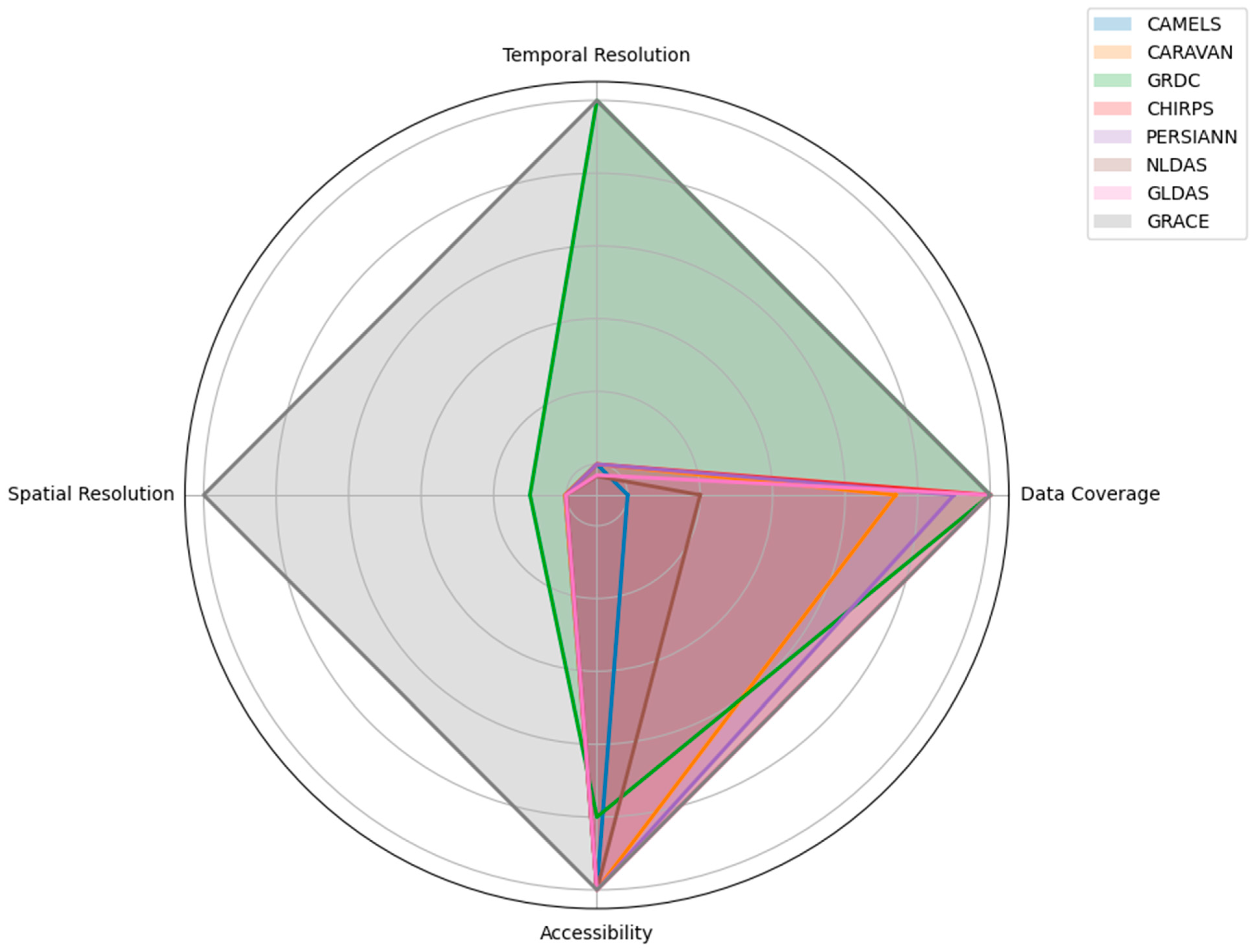
| Dataset | Spatial Coverage | Temporal Coverage | Data Resolution | Key Attributes | Primary Applications |
|---|---|---|---|---|---|
| CAMELS | 671 catchments in CONUS | 1980–2014 | Daily | Topography, climate, streamflow, land cover, soil, geology | Large-sample hydrological studies, catchment attribute analysis |
| Caravan | 6830 catchments globally | Nearly four decades | Sub-daily | Meteorological forcing, streamflow, static catchment attributes | Global hydrological studies, extensibility for new locations |
| GRDC | 9800 stations worldwide | Up to 200 years | Daily, monthly | River discharge data | Global water resource management, climate impact studies |
| CHIRPS | Global | 1981–present | Daily, pentadal, monthly; 0.05° spatial resolution | Precipitation estimates | Climate extremes monitoring, drought forecasting |
| PERSIANN (CCS, CDR, CCS-CDR) | Near-global (60°S to 60°N) | CCS: 2003–present CDR: 1983–present CCS-CDR: 1983–present | CCS: 0.04°; hourly, 3-hourly, 6-hourly, daily, monthly, yearly CDR: 0.25°; daily CCS-CDR: 0.04°; 3-hourly | Precipitation estimates | CCS: real-time weather monitoring, short-term forecasting, severe weather analysis CDR: long-term climatological studies, precipitation analysis CCS-CDR: extreme weather event analysis, climatological studies, hydrological modeling |
| GLDAS | Global (north of 60° S) | 1948–present | 3-hourly; 1 degree and 1/4-degree spatial resolution | Land surface states and fluxes | Global land surface condition monitoring, hydrological modeling |
| GRACE | Global | 2002–2017 (GRACE), 2018-present (GRACE-FO) | Monthly; 1-degree spatial resolution | Gravitational field variations | Water distribution and mass transport studies, groundwater depletion analysis |
| Dataset | Applications | Case Studies and Findings |
|---|---|---|
| CAMELS | Streamflow forecasting | LSTM with transfer learning outperforms locally trained models in Chile and China [83]; LSTM networks outperform traditional models [85]; Data integration improves accuracy [90]; multi-task learning enhances predictions [91]. |
| Rainfall-runoff modeling | The LSTM with multiple meteorological forcings improves accuracy [96]; the PHY-LSTM integrates physical mechanisms [97]; transformer-based RR-former outperforms LSTM models [126]; MDNs and Monte Carlo Dropout address prediction uncertainties [102]. | |
| Flood forecasting | The ML framework for flood peak prediction [33]; random forest models for climate attributes influencing flood processes [104]; extreme gradient boosting for design flood estimation [105]. | |
| Groundwater level forecasting | Improved model performance by integrating regional characteristics [107]; combining water balance-based processes with deep learning outperforms pure deep learning models [108]. | |
| Other hydrological applications | Differentiable, physics-informed machine learning models demonstrate their generalizability to ungauged regions [111]; MC-LSTM models performed comparably to standard LSTM models [112]; AI4Water enhances model accuracy and interpretability [110]. | |
| CAMELS-GB | Streamflow and hydroclimatic impacts | Urbanization impacts on river discharge [117]; hybrid hydroclimatic forecasting [118]. |
| CAMELS-CL | Hydrological predictions | LSTM and random forest models enhance predictions [120]; a deep neural network for 24-hour streamflow forecasting [121]. |
| CAMELS-BR | Streamflow prediction | The FS-LSTM model shows improved performance for streamflow prediction [123]. |
| CAMELS-AUS | Streamflow prediction and water flux | A hybrid model combining GR4J with CNN and LSTM networks [124]; the global analysis of water flux partitioning [125]. |
| Caravan | Streamflow and flood prediction | Temporal fusion transformers outperform the LSTM and transformer models [127]; a two-path LSTM model for river flood prediction [128]; LSTM models outperform traditional models in streamflow prediction [129]. |
| Catchment model instance prediction | A latent factor model for predicting catchment model instance associations [130]. | |
| Task-aware modulation in predictions | Task-aware modulation using representation learning (TAM-RL) for GPP and streamflow predictions [131]. | |
| GRDC | Streamflow and water balance | Improved monthly runoff reconstructions [29]; a physics-encoded deep learning framework for streamflow predictions [30]; a flood type analysis across Europe [132]. |
| Flood prediction and analysis | An AI-based model to predict extreme floods in ungauged watersheds [133]. | |
| Hydrological modeling and simulation | A DHI-GHM model for real-time and forecasted hydrological simulations globally [134]; evaluated objective functions for streamflow prediction, showing the LSTM excels in high-flow forecasting [135]. | |
| CHIRPS | Drought assessment | A drought assessment in Ethiopia [136]; predicting drought-induced reductions in agricultural productivity [137]; integrated CHIRPS for drought assessment in Iran [138]. |
| Runoff estimation and streamflow | CHIRPS’s performance in Saudi Arabia [18]; enhanced streamflow forecasting in India’s Varahi River basin [19]; better performance of CHIRPS over IMD data for streamflow forecasting [139]. | |
| Flood modeling and susceptibility | Flood susceptibility modeling in Iran [140]; combining CHIRPS data with a soil water index for enhanced rainfall-runoff model accuracy [141]. | |
| Precipitation model improvement | Bias correction methods for downscaling precipitation models using CHIRPS in high-altitude regions [142]. | |
| PERSIANN | Hydrological modeling | Hydrological and coupled soft computing models for streamflow and sediment load [20]; ML and process-based models for rainfall-runoff in the DuPage River Basin [21]. |
| Flood prediction | Forecasting extreme flood events using satellite precipitation and wavelet-based ML [22]; improving hourly precipitation estimates for flash flood modeling in the Andean-Amazon basins [23]. | |
| Precipitation estimation | cGANs for real-time precipitation estimation from GOES-16 imagery [24]; a two-stage deep neural network for precipitation estimation from bispectral satellite information [25]. | |
| Drought assessment | Hybrid ensemble learning for super drought computation in the Lake Victoria Basin [26]. | |
| Runoff simulation | A runoff simulation using multi-source satellite data and deep learning [27]; a fusion-based framework for daily flood forecasting in the Kan River, Iran [28]. | |
| NLDAS | Hydrological modeling | Process-guided deep learning for lake water temperatures [143]; spatial downscaling of precipitation [42]. |
| Runoff and flood prediction | ML models to predict hourly runoff in California’s Russian River basin [144]; predicting flash flood damage in the Southeast US [145]. | |
| Soil moisture and evapotranspiration | Enhanced soil moisture estimation [146]; a downscaling algorithm for soil moisture estimation [147]. | |
| GLDAS | Hydrological modeling | An LSTM-based model for terrestrial water storage [148]; a combined hydrological model for streamflow simulations in Thailand [149]. |
| Soil moisture and evapotranspiration | Estimating surface soil moisture using GBRT [150]; evaluating global land evapotranspiration (ET) products [151]. | |
| Groundwater and storage data | Improving groundwater level anomaly predictions [152]; downscaling groundwater storage data using ML techniques [152]. | |
| GRACE | Groundwater and water storage | Downscaling GRACE TWSA data with boosted regression trees [153]; random forest models highlight groundwater storage loss [154]; SVM models for groundwater level prediction [155]; the XGBoost model to downscale GRACE-derived groundwater storage data in the Indus Basin [156]. |
| Groundwater level prediction | Combined SVMs with ensemble Kalman filtering [157]; RF and SVM models for monitoring groundwater fluctuations [9]. | |
| Enhancing spatial resolution | The AutoML workflow for reconstructing GRACE TWSA data [158]; RF and hydrological models for higher accuracy in the Haihe River Basin [159]. |
| Aspect | Shortcomings of Traditional Methods | How High-Resolution Datasets Address These Shortcomings |
|---|---|---|
| Precipitation Monitoring | ||
| Rain gauges | Point-specific data, sparse distribution, maintenance required | High-resolution satellite data (e.g., PERSIANN-CDR and CHIRPS) provide comprehensive coverage and effectively capture spatial and temporal patterns of precipitation [205,206]. |
| Thiessen polygons | Assumes uniform precipitation within polygons, inaccurate for heterogeneous landscapes | Datasets like CHIRPS and PERSIANN provide finer spatial resolutions, which are 0.05 degrees and 0.04 degrees, respectively. |
| Isohyetal method | Labor-intensive, subjective, relies on the manual drawing of isohyets | Automated algorithms in datasets like PERSIANN offer consistent and objective estimates. |
| Empirical models | Dependent on historical data quality and availability, less reliable under varying climatic conditions | The NLDAS and GLDAS provide detailed temporal and spatial data, enhancing model accuracy. |
| Streamflow Assessment | ||
| Stream gauges | Measures water levels at specific points, limited spatial coverage | GRDC offers extensive global streamflow records. |
| Hydrological models | Based on simplified assumptions, extensive calibration and validation needed | The NLDAS and GLDAS enhance model inputs and improve accuracy by integrating advanced observational data [203]. |
| General Data Issues | ||
| Sparse data coverage | Many regions lack sufficient ground-based measurements | High-resolution satellite datasets (e.g., PERSIANN, CHIRPS) provide global coverage. |
| Inconsistent data formats | Varying formats and standards make it difficult to integrate data from different sources | The CARAVAN project and FAIR data principles improve standardization and interoperability [16,202]. |
| Temporal resolution | Limited temporal resolution, missing short-term variations | The NLDAS offers hourly data, the GLDAS provides three-hourly to monthly data |
| Data gaps and missing values | Equipment failure or loss of data leads to gaps in traditional datasets | CAMELS and Caravan offer consistent data coverage, minimizing gaps |
| Regional bias | Traditional datasets often focus on specific regions, limiting applicability to other areas | High-resolution global datasets (e.g., PERSIANN, GLDAS, GRACE) provide universally applicable data |
| Extreme event detection | May fail to capture extreme weather events accurately | High-resolution datasets improve the detection and modeling of extreme events [206]. |
| Data quality and consistency | Variations in measurement techniques and data quality introduce inconsistencies | Standardized high-resolution datasets ensure more consistent data quality |
| Method | Description | Applications | Impact on Hydrological Models |
|---|---|---|---|
| Bayesian approaches | Updates probabilities with new data, incorporates prior knowledge. | Bayesian hierarchical models for multi-level uncertainty quantification [220]. | Comprehensive uncertainty assessment, enhanced robustness. |
| Machine learning techniques | Generates output distributions using ensemble and deep learning methods. | Random forest models provide uncertainty estimates [221]. | Improved predictions, better variability representation. |
| Monte Carlo simulations | Runs models with different input parameters [222]. | Quantifies the error of satellite rainfall estimation [223]. | Quantifies outcome range, better risk assessment. |
| Stochastic modeling | Incorporates random variables to represent variability. | Improves rainfall simulation with multi-zone calibration for complex terrains and sparse data [224]. | Enhances hydrological models, improving crop yield forecasts and water management. |
| Sensitivity analysis | Assesses output variation due to different input parameters. | Global sensitivity analysis with Sobol indices [225,226]. | Identifies key uncertainty sources, guides data collection. |
| GLUE (generalized likelihood uncertainty estimation) | Runs multiple simulations with different parameters, evaluates likelihood. | Estimates the uncertainty of water resource modeling, including quality, rainfall-runoff, and groundwater modeling [227]. | Enhances parameter sensitivity understanding and performance. |
| Bootstrap methods | Resampling technique for estimating statistic distribution. | Assesses parameter and prediction uncertainty [228]. | Provides confidence intervals, enhances prediction reliability. |
| Data assimilation | Integrates observations with predictions for accuracy. | Ensembles the Kalman filter in the NLDAS and GLDAS. | Reduces uncertainty, updates model states with observed data. |
| Polynomial chaos expansion | Expands random variables onto orthogonal polynomials. | Groundwater flow modeling. | Efficient uncertainty quantification in complex models. |
| Bayesian model averaging | Combines predictions from multiple models weighted by their probabilities. | Combines hydrological model predictions [229]. | Reduces model uncertainty by averaging, provides reliable predictions. |
Disclaimer/Publisher’s Note: The statements, opinions and data contained in all publications are solely those of the individual author(s) and contributor(s) and not of MDPI and/or the editor(s). MDPI and/or the editor(s) disclaim responsibility for any injury to people or property resulting from any ideas, methods, instructions or products referred to in the content. |
© 2024 by the authors. Licensee MDPI, Basel, Switzerland. This article is an open access article distributed under the terms and conditions of the Creative Commons Attribution (CC BY) license (https://creativecommons.org/licenses/by/4.0/).
Share and Cite
Hasan, F.; Medley, P.; Drake, J.; Chen, G. Advancing Hydrology through Machine Learning: Insights, Challenges, and Future Directions Using the CAMELS, Caravan, GRDC, CHIRPS, PERSIANN, NLDAS, GLDAS, and GRACE Datasets. Water 2024, 16, 1904. https://doi.org/10.3390/w16131904
Hasan F, Medley P, Drake J, Chen G. Advancing Hydrology through Machine Learning: Insights, Challenges, and Future Directions Using the CAMELS, Caravan, GRDC, CHIRPS, PERSIANN, NLDAS, GLDAS, and GRACE Datasets. Water. 2024; 16(13):1904. https://doi.org/10.3390/w16131904
Chicago/Turabian StyleHasan, Fahad, Paul Medley, Jason Drake, and Gang Chen. 2024. "Advancing Hydrology through Machine Learning: Insights, Challenges, and Future Directions Using the CAMELS, Caravan, GRDC, CHIRPS, PERSIANN, NLDAS, GLDAS, and GRACE Datasets" Water 16, no. 13: 1904. https://doi.org/10.3390/w16131904
APA StyleHasan, F., Medley, P., Drake, J., & Chen, G. (2024). Advancing Hydrology through Machine Learning: Insights, Challenges, and Future Directions Using the CAMELS, Caravan, GRDC, CHIRPS, PERSIANN, NLDAS, GLDAS, and GRACE Datasets. Water, 16(13), 1904. https://doi.org/10.3390/w16131904