Abstract
Rivers are one of the most complex formations on the Earth’s surface; they are connected with the deep structure of the Earth, the landscape environment, and unpredictable weather cataclysms. The study aims to investigate the peculiarities of the geological structure and tectonics of the Lower Dniester region, examine the types of meanders, determine the horizontal displacements of the riverbed, and assess the impact of anthropogenic factors on the riverbed and riparian areas. The methodology is based on the use of tectonic maps, geological maps of Quaternary deposits, historical topographic maps, and satellite images to determine the long-term horizontal displacements of the riverbed, identify meander types, and study the meandering characteristics and their relationships with tectonic structures. Horizontal riverbed displacements were measured at 76 points using data from the 1980 map and a Sentinel-2 image obtained in 2020. For the purpose of studying the types of meanders and their analysis, it is proposed to use the characteristics of meanders and their relationships. This approach will allow for more efficient analysis and prediction of changes in channel processes under the influence of natural and anthropogenic factors across various temporal scales. The research shows that the Lower Dniester region is influenced by the tectonics of internal structures and the seismically active Vrancea zone in Romania. Additionally, a comparison of cartographic data from 1880 and 1980 and satellite images from 2020 allows us to assess how the territory of the Lower Dniester riparian area has changed under the influence of anthropogenic factors.
1. Introduction/Relevance
Restoring and preserving natural ecosystems is the basis of sustainable development in Europe. In recent years, European states have increasingly adopted decisions aimed at stopping global climate change and guaranteeing a reliable future for the entire continent. Back in May 2020, the European Commission presented an ambitious environmental protection document in the history of Europe, the EU Biodiversity Strategy for 2030 “Returning Nature to Our Lives” [1]. The strategy contains specific commitments and actions that must be implemented in the EU by 2030. Among the most ambitious goals of the document, at least 30% of land and 30% of marine water areas should become protected areas, at least 10% of agricultural land must be removed from cultivation and restored to natural ecosystems, and the use of pesticides should be reduced by 50%. As for the rivers, which are called the arteries of life, at least 2500 km of rivers are planned to be restored to a state of free flow.
The relevance of the problem of preserving natural resources, in particular drinking water, is indicated by the Concept of Sustainable Development of Nature and Society, adopted for the 21st century in Rio de Janeiro in 1992 [2], as well as by a series of governmental resolutions of states and internationally adopted programs regarding the protection of rivers and the reduction of flood and flooding phenomenon risks [3].
Cadastral activities in riparian territories depend on channel processes, in particular the selection of water protection zones [4] and forecast of flooded land zones [5,6]. These processes also influence the choice of hydroengineering construction methods, such as bridges, roads, and river crossings of gas transmission lines [7], as well as transboundary cooperation in selecting interstate borders along river fairways and the utilization of water resources by different states. Modern technologies for obtaining and processing information using data from remote sensing of the Earth and geoinformation systems have opened up new opportunities for solving the tasks of monitoring channel processes [8,9,10,11].
Further monitoring of the Lower Dniester, which flows through two states, Moldova and Ukraine, with the use of topographic maps, satellite imagery, geological and tectonic maps, as well as soil cover maps for different periods remains relevant.
Modern technologies for obtaining and processing information using Earth remote sensing data and geoinformation systems have opened up new opportunities for solving the tasks of channel process monitoring.
Each river has characteristics that depend on its location, features of the basin, geological structures, tectonics of the region, lithology, as well as climatic changes of the region, so each river is studied separately.
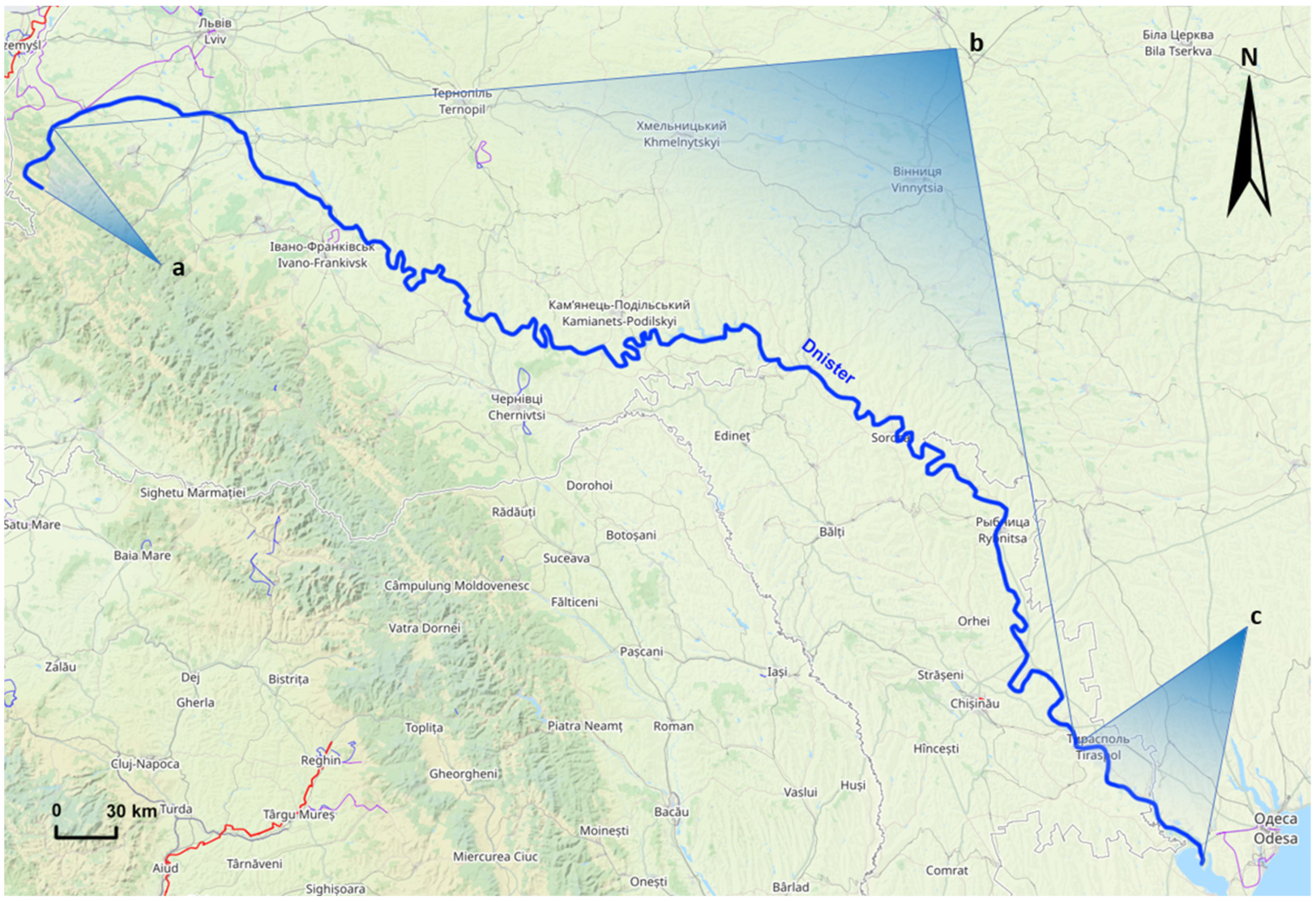
Geomorphologists classify the second largest river in Ukraine, the Dniester, into three parts based on the morphology of the area and the nature of the flow: Upper, Middle, and Lower Dniester (Figure 1), which are fundamentally different from each other. [12]. However, in terms of significant deformations for practical use, the smaller structures of the Middle Dniester notably differ [13]. In the area of the Middle Dniester, taking into account the values of channel displacement, it is possible to distinguish foothill, plain–marsh, plain, and canyon parts of the channel [14]. Due to different water supply conditions, water regimes, and physical, geographical, and geological features, all parts of the Dniester differ structurally.

Figure 1.
The Dniester River in the Upper (a), Middle (b), and Lower (c) sections (data source: Open Street Map and own research).
In recent decades, considerable attention has been paid to the hydrological and morphological direction of research on channel processes, driven by the need to consider the regularities of the natural environment’s influence on channel processes [15]. The hydrological–morphological environment allows for a more comprehensive consideration of the intensity of horizontal deformations in river sections of considerable length, which cannot be achieved using a hydrodynamic approach alone [16]. The hydrological–morphological approach is particularly effective in conditions of insufficient amount of input data and at the preliminary stages of design [9,17].
Some authors [18,19,20] indicate that the hydrogeomorphological approach allows for the prediction and analysis of horizontal displacements of the alluvial riverbed in the floodplain.
In [21,22], it is emphasized that this direction of the theory of channel processes is based on the generalization of channel forms and formations and on the determination of the rates of their movement to develop predictions of channel changes. Channel processes depend on the natural and anthropogenic factors characterizing the watershed landscape [23,24,25]. Special attention in the study of characteristic features of rivers is given to such a natural factor as meandering.
The analysis of the nature of meandering development is considered in [26], indicating two types of meanders that are formed under different conditions: if the river flows over friable, soft rocks, and if the river is connected with the relief of the earth’s surface. In [27], it is emphasized that channel processes are closely related to the environment, channel morphology, and floodplains. V. Lokhtin examined the conditions for the formation of channels of small rivers, proposed indicators of channel stability, and analyzed the influence of the hydrological regimen of rivers on the deformation of the Dniester riverbed [28].
Popov I. studied the morphology of river channels and developed the fundamental principles of hydro-morphological theory, in particular, the effect of erosion-accumulation processes on the riverbed [29].
K. Gerenchuk formulated the influence of tectonics on the river network, which he studied with the example of the rivers of the Russian Plain using the known facts of the hydrographic network reconstruction. He believed that the cause of channel reconstruction was tectonic movements, and the active force that directly affected the channel reconstruction was river erosion along with landslides [30].
A series of questions related to the peculiarities of the morphology of the region and its influence on the characteristics of rivers in Ukraine is presented in [31]. Engineering calculations can only be sufficiently justified if they take into account the direction and intensity of channel processes, their possible changes, and the specificity of their manifestation under different conditions, both in their natural development and through the influence of economic measures.
A significant contribution to the study of geomorphology in the Ukrainian Carpathians and its influence on hydrological processes in the region has been made by I. Kovalchuk [32,33]. The distribution of modern relief-transforming processes in the Ukrainian Carpathians has been analyzed, the characteristics of hydrography have been described, and an assessment of the impacts of natural and anthropogenic factors on the hydrological regime of rivers has been provided. Parameters of aquifer capacity, water balance, and water and sediment discharge regimes in rivers of the region have been presented. Additionally, the main features of natural conditions and management determining the specificity of the hydrological regime of rivers in the Ukrainian Carpathians have been discussed.
All studies on channel processes can be divided into two main directions: hydrodynamic, which examines the flow kinematics at the bend of the channel, circulation currents, distribution of flow velocities, and others; and hydro-morphological, which focuses on bend forms, their evolution, displacement, stages of development, conditions of straightening, and bank erosion.
Geomorphologists distinguish between two types of bends: if the river flows through soft rock, there are free meanders and entrenched meanders, which are confined by the bends of the natural banks. The first type is formed as a result of the water flow itself, while the second type is associated with the relief of the Earth’s surface. It is emphasized that the development of the river valley is exclusively associated with the meandering of the river channel.
The question of the impact of active tectonics on meandering is discussed in [34,35,36]. It is assumed that the meanders of the Middle and Lower Dniester in certain sections correspond to fault lines, which determine the peculiar shapes of some bends and the presence of sharp turns in the river channel. This fact is considered by some researchers as sufficient evidence for concluding the structural nature of incised bends in the Middle and Lower Dniester.
The relationship between incised bends and tectonic movements, faults, and the block structure of the basement has been repeatedly discussed in the literature, often in a reverse correlation: the reconstruction of faults and other structures was carried out based on the configuration of incised bends. Incised meanders are formed in the place of free meanders due to intense deep erosion at the stage of active uplift tectonic movements that encompass the entire watershed or only its part. During the stabilization of the base of erosion, meanders constantly shift downstream. Unlike free bends, incised bends are not flooded by floodwaters; each meander bend contains a protrusion of the main slope of the river valley or its floodplain terrace.
The application of this analysis to meandering channels has shown that, theoretically, free meandering can be developed on rivers with different channel stabilities except for absolutely stable ones, which are characterized by incised meanders only. The conditions under which free bends are developed in a stable channel are less common. An example of a meandering stable channel for lowland rivers is the lower course of the Dniester River (from the Dubossary Hydroelectric Power Station to its mouth).
The floodplain in this section is composed of cohesive clayey deposits, which significantly reduce the intensity of channel deformations and promote the development of free bends of a specific shape: “finger-like”. Such channel formation conditions are typical for the Lower Dniester region.
However, the question remains open due to the complexity of the detailed consideration of factors such as floodplain characteristics, erosion features, landscape changes, anthropogenic impacts on channel processes, and so on.
While the first two sections from the source to Mohyliv-Podilskyi (southern Ukraine) have been significantly better studied regarding riverbed deformations and stability, the lower part of the Dniester River is primarily considered only concerning ecological and anthropogenic issues, such as electricity generation sources (three power stations built in Ukraine, with one in Moldova), as well as significant water extraction in southern Ukraine and Moldova for agricultural purposes. Despite the significant anthropogenic impact in this southern region, with the river channel and riparian areas undergoing substantial changes, the deformation analysis of the Lower Dniester has not received adequate attention.
1.1. Study Area
Object: The present study concerns the second largest river in Ukraine, the Dniester, which has a length of 1362 km and a basin area of 72.1 thousand sq. km (52.7 thousand sq. km within Ukraine; the northern part of the basin belongs to Poland, and the southern part to Moldova).
Characteristics of the Lower Dniester River
In the lower Black Sea region, the river flows mostly through the southeastern territory of Moldova (Figure 1). Below the city of Tiraspol, a full-flowing left thread called Turunchuk separates from the Dniester River and merges back with the main channel further downstream in the Odesa region. Further down, the length of the Dniester, where it flows in one stream, is only 9 km. In the Odesa region, the river once again splits into two threads. The right thread is named Deep Turunchuk, while the left (navigable) thread is called the Dniester. In the lower course, the Dniester crosses the Black Sea Lowland. The valley widens, reaching 16–22 km near the mouth, with a channel width of 100–200 m and depths ranging from 4–8 to 10–16 m on shoals. The floodplain is divided by numerous channels and oxbow lakes. The estuary area is overgrown with reeds and is known as the Dniester Reedbed. The Dniester Lowlands, particularly the area where the Dniester merges with the Turunchuk River, are included in the international list of the Ramsar Convention on Wetlands Protection. Within the territory of the Odesa region lies the Nature Reserve “Dnistrovski Plavni”.
Based on an analysis of the literature and previous research on various sections of the Dniester River [37], the aim and objectives of the work have been formulated.
1.2. Aim of the Study
To investigate the peculiarities of geological structure and tectonics of the Lower Dniester region, we examine the types of meanders characterizing the features of river channel processes, determine the horizontal displacements of the riverbed, and assess the impact of anthropogenic factors on the riverbed and riparian areas.
The task is as follows:
- Examine the tectonic structure and characteristics of meanders in the Lower Dniester and analyze the main types of meanders and their dependence on lithological and tectonic structures;
- Investigate the accuracy of historical cartographic materials for determining horizontal deformations of the Lower Dniester riverbed over a long period;
- Determine the horizontal displacement of the river based on measurements from topographic maps and satellite images;
- Show the impact of anthropogenic factors on the riparian territory and channel processes of the Lower Dniester area.
River-forming factors are represented by three main elements, each independent of the other, namely (1) water abundance, which is determined by atmospheric and soil conditions of precipitation within the river’s territory and the inflow of these waters into the river; (2) slope, or steepness, determined by the relief; and (3) riverbed stability, which depends on the geological layers of the Earth through which the channel flows and the tectonics of the region.
2. Materials and Methods
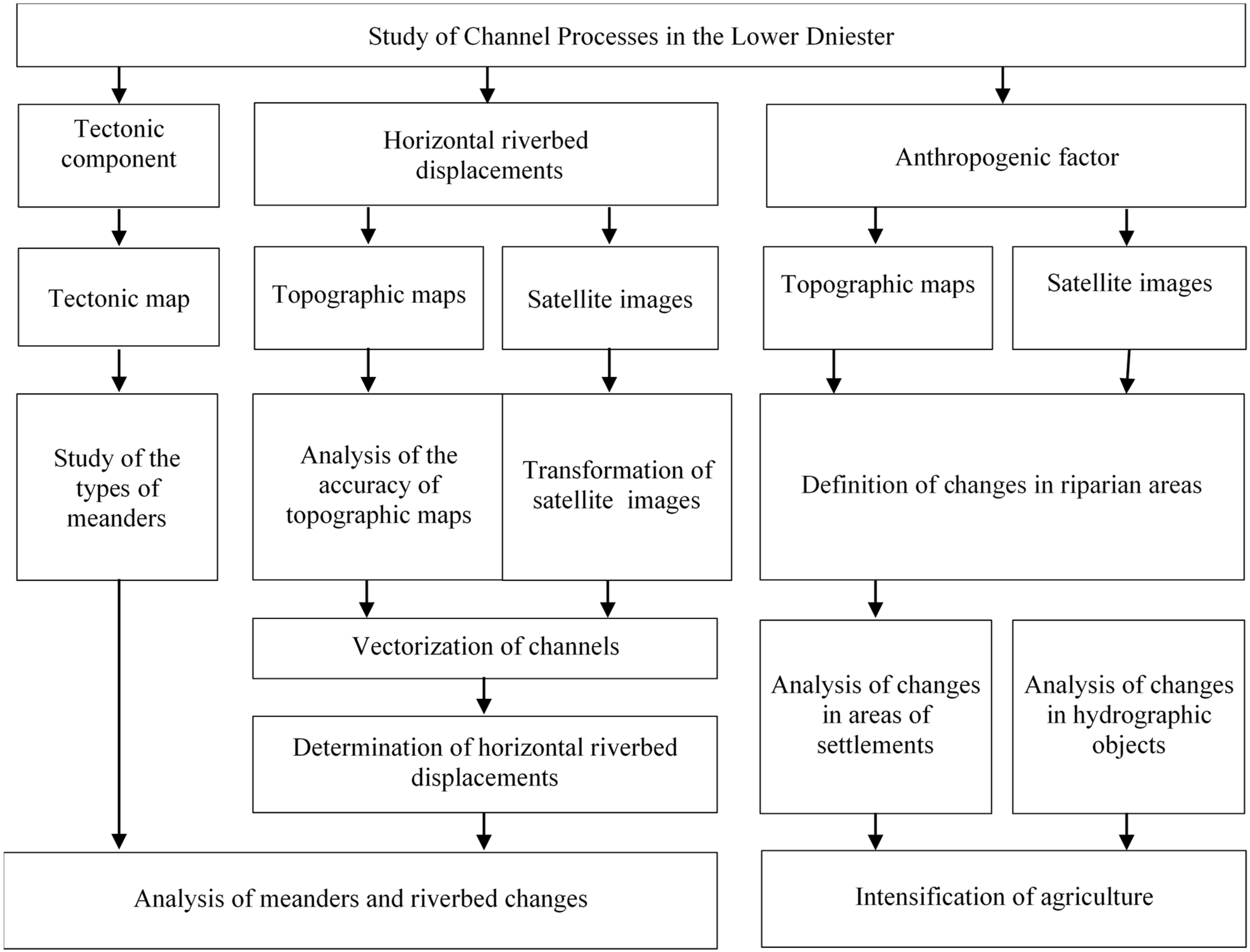
The methodology based on the use of tectonic maps, geological maps of Quaternary deposits, historical topographic maps, and satellite images was employed to investigate channel processes in the Lower Dniester, particularly to determine the long-term horizontal displacements of the riverbed, identify the meander types, and study the meandering characteristics and their relationships with tectonic structures. The structural scheme of the study workflow encompasses three research directions: the first direction pertains to determining horizontal riverbed displacements, which serve as criteria for channel stability; the second involves examining geological and tectonic structures of the region and the associated meander types and characteristics; and the third direction is related to studying the impact of anthropogenic factors on channel processes and changes in riparian territories.
The structural scheme of the study workflow is presented in Figure 2.
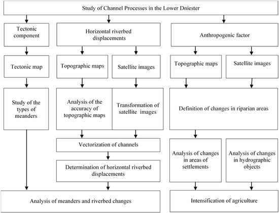
Figure 2.
Structural scheme of study workflow on channel processes of the Lower Dniester and their impact on riparian areas.
The research was conducted on a 300 km stretch of the Lower Dniester, from Tiraspol to the river’s estuary in the Liman. The following data were used for the study:
- Russian topographic 3 verst maps at a scale of 1:126,000 from 1880;
- Soviet maps at a scale of 1:100,000 from 1980;
- A set of satellite images from the Sentinel imaging system for the years 2020 and 2023.
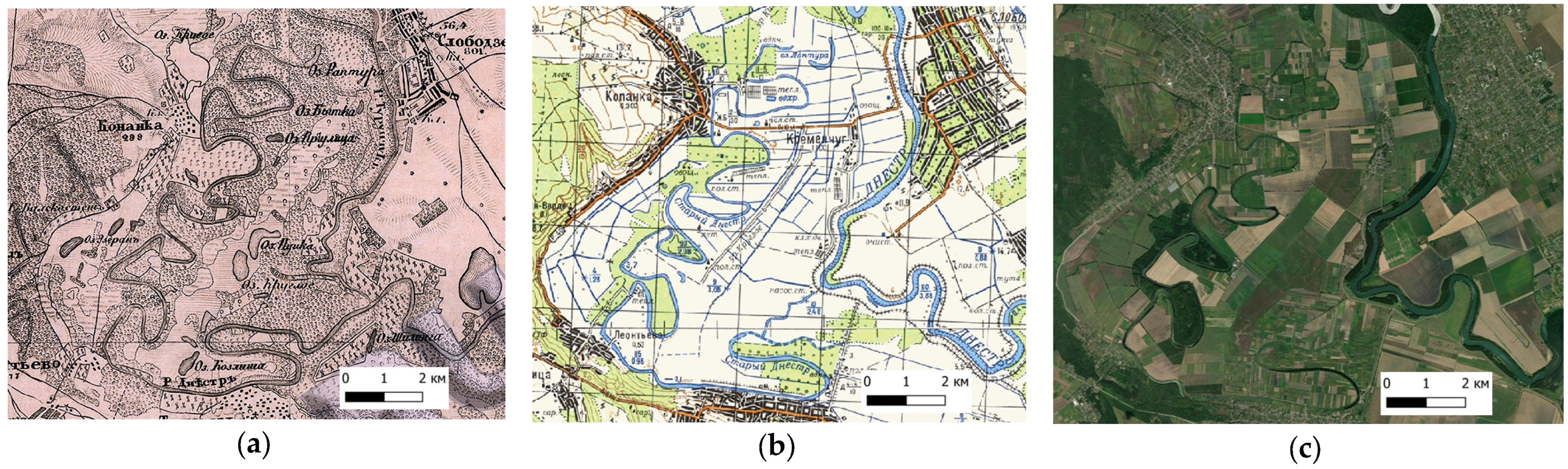
The map from 1880 is the oldest historical map of this region available from online sources (see Figure 3a).
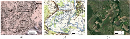
Figure 3.
Depiction of a part of the Lower Dniester: (a) the topographic map from 1880; (b) the topographic map from 1980; (c) the satellite image obtained from the Sentinel 2 satellite in 2020 (data sources described in detail in Table 1).
Figure 3a depicts a map from 1880, where the left part of the map clearly shows the bed of the Old Dniester River, mistakenly referred to as the Dniester due to analogies with older maps until the powerful earthquake of 1838. In the right part of the map, we see the name of the Turunchuk River, although this channel was taken over by the Dniester River. Consequently, due to the uplift of the Moldavian Plate caused by the earthquake, the Dniester shifted eastward and merged with the waters of the Turunchuk River. Remarkably, the Old Dniester, a giant oxbow lake filled with water, still exists and is nourished by underground waters. In the Soviet map of 1980 (Figure 3b), the names Old Dniester and Turunchuk were already used to identify the rivers. Even a visual comparison of these two maps allows us to see significant landscape changes. The 1880 map shows a marshy area with lakes, few small settlements, and sparse vegetation, mostly reed beds. A different picture is observed on the 1980 map (Figure 3b). Firstly, the scale of reclamation is impressive; the entire central plain between the remnants of the riverbed called Old Dniester and the Dniester, which changed its course after the earthquake of 1838, is covered with drainage canals. Along the Dniester riverbed, bank protection works have been carried out, new roads have been built, lakes have disappeared, a network of greenhouses has developed, and reservoirs have appeared. Figure 3c shows an image obtained from the Sentinel 2 satellite in 2020, characterizing a new stage of development of the territory, where settlements, as on the 1980 map, have significantly expanded, and agriculture is intensively conducted, which is evidenced by the shape of the plots in the form of geometric figures.
Definition of Horizontal Displacements
Horizontal displacements of riverbeds affect the selection of river protection zones, which serve to protect rivers from anthropogenic factors, as well as the methods of hydraulic engineering construction at river crossings and protection of riparian areas from floods. To obtain the necessary information, monitoring of the riverbed condition is conducted, especially after significant flood and inundation phenomena, which have the greatest impact on the deformation processes of the riverbed. Therefore, to analyze the changes in riverbeds and adjacent territories, the longest periods of research are used as far back as possible. The primary effective method for predicting channel changes is a hydro-morphological analysis based on various information, which involves combining and analyzing the current and past configurations of the river channel. The main factors influencing river channel formation include floods and inundations; lithological structures and hydrogeology; neotectonic movements, earthquakes, and landslides; flora and fauna in the basin area; sediment accumulation and erosion on the floodplain; and Coriolis acceleration.
The territory under consideration, due to its remoteness from civilization centers, began to develop more intensively in the 20th century. However, already in the late 19th century, a three-verst military topographic map was created for the territory of the Lower Dniester basin, which belonged to Russia at that time. Maps covered all the European provinces of Russia. Depending on the year of publication, there are several versions of the same sheets of the military topographic map, which may differ from each other in the presence of railways and names of settlements, and may include or, on the contrary, lack certain villages, hamlets, mills, etc. As for river channels, due to their tendency to change, bends were carefully depicted on the three-verst map.
The features of the three-verst map are as follows: it has a scale of 1:126,000, main parallel at a 52° latitude, and the central meridian, which serves as the coordinate axis, passes through the Pulkovo Observatory. As of today, the Pulkovo meridian has a value of approximately 30°19′34″ east longitude.
Based on historical data, the anticipated coordinate system of the three-verst map is close to the Walbecka 1819 ellipsoid (compression 1/302.78; major axis 6,376,896 m).
A three-verst military topographic map is constructed using the Bonne projection (pseudoconical equal-area cartographic projection).
Errors resulting from imperfect measurements in the 19th century and their processing include choosing the ellipsoid, map projection, mistakes in engraving, sheet shrinking over one and a half centuries, as well as distortions from scanning. The biggest error in this case can be introduced by incorrectly chosen calibration points of up to 50–200 m. To select such points, all objects intersecting one of the meridians on the map sheet in the required area are reviewed, where a calibration point can be chosen. First and foremost, we look for intersections with major roads, railways, and significant geographic features: churches and clear outcrops of rock that have not changed their location in 150 years.
It is evident that the use of ancient maps, referred to as historical, is possible for studying global channel processes that correspond (align) with the accuracy of these maps.
The main materials for the study of the channel of the Lower Dniester are presented in Table 1.

Table 1.
Materials for the study of the channel of the Lower Dniester.
The main processes of determining horizontal channel displacements in the methodology are as follows: map georeferencing, digitizing of channels on maps and images, measuring displacements over a specific period, and analyzing the results [38].
3. Results and Analysis
3.1. Map Accuracy and Horizontal Displacements
The analysis of the map’s accuracy was the first procedure and considered the input parameters of the topographic map from 1880. It was conducted using 20 identified points on sheets L30-8 and L31-8. A second-degree polynomial transformation function was selected. The root mean square error after calculations was 208 m. It has been established that significant distortions due to the projection of the 1880 map, engraving errors, and deformation of the paper base during map production reach up to 200 m and are proportional to the displacement itself. The determined accuracy indicates the impracticality of using the 1880 map to determine channel displacements. This map was subsequently used for a general analysis of the riparian area.
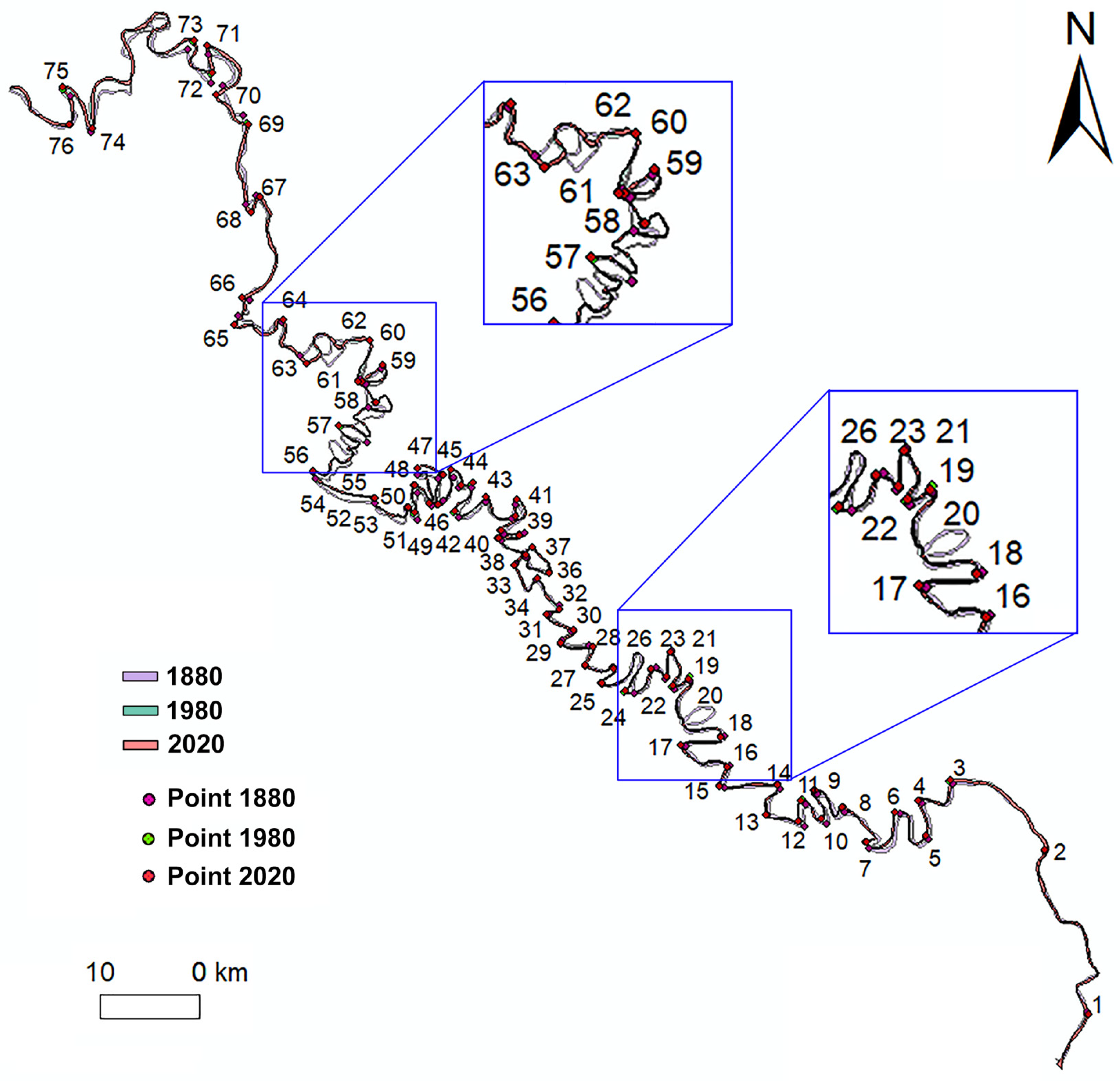
Horizontal riverbed displacements were measured at 76 points located at characteristic bends of the river (Figure 4). For their analysis, digitized images from the 1980 map and a satellite image obtained from the Sentinel 2 satellite in 2020 were considered. The measurement results are given in Table 2. The determination of riverbed displacements from 1980 to 2020 was carried out with an average square error of 20–25 m. Similar studies related to the accuracy of determining the Dniester riverbed displacements in its middle part are presented in [37,38]. The main errors in determining riverbed displacements from 1980 to 2020 are the identification of points during the 1980 map georeferencing.
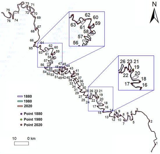
Figure 4.
Diagram of the digitized section of the channel of the Lower Dniester.
Table 2.
Displacement of the riverbed for the period 1980–2020.
Horizontal riverbed displacements were measured at 76 points located at characteristic bends of the river (Figure 4). For their analysis, digitized images from the 1980 map and a satellite image obtained from the Sentinel 2 satellite in 2020 were considered. The values of displacements in percentages from the total number of measurements (76 points) are within the following ranges: 1–50 m, 41%; 51–100 m, 38%; 101–150 m, 17%; 151–200 m, 4%. Therefore, 79% of the points over 40 years of deformation determination correspond to average annual displacements, ranging from 1 to 2.5 m. These values of average annual displacements correspond to a stable riverbed [14].
The stabilization of the riverbed can be explained by natural conditions of the riverbed flow, including lithological features, significant hydraulic engineering works, hydromelioration, and reduced water flow due to anthropogenic factors.
3.2. Tectonic Factor
The Dniester River crosses the Black Sea Lowland, which is part of the platform structure of the Black Sea Basin. The crystalline basement of the structure is submerged at varying, generally significant depths. Its surface slopes from north to south, from the Ukrainian Shield towards the Black Sea. The relief, composition of sedimentary rocks, their distribution, and tectonics have a certain connection with the structure of the Black Sea Basin. The difference in elevation within the Black Sea Lowland does not exceed 100 m.
The Dniester River has a wide valley here with well-defined terraces. The so-called Tiraspol terrace, composed of gravel, is particularly extensive, along with a series of younger, lower terraces. The main valleys are very wide, with high right, western banks. The eastern banks are lower and terraced. Steep banks are dissected by shallow gullies and landslides. The majority of valleys in their lower parts contain large saline lakes or gulfs. The elevations average 90–150 m.
We display the Dniester riverbeds of different periods on the tectonic map of the region (Figure 5).
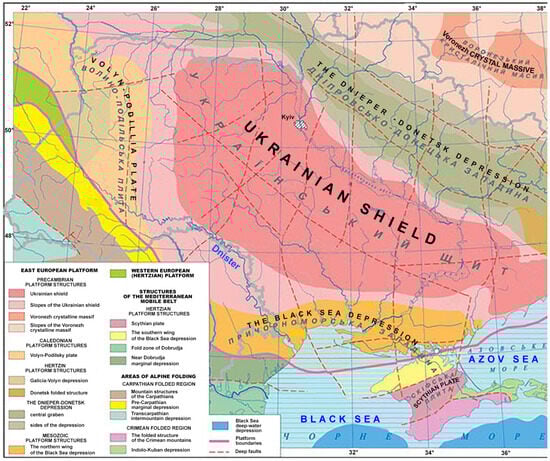
Figure 5.
Tectonic map of the region (modified based on the map available on https://geomap.com.ua/uk-g8/864.html, accessed on 15 January 2024).
By its tectonic structure, the Black Sea Lowland is a part of the Black Sea Depression, filled with nearly horizontal thick layers of sedimentary rocks, mainly marine deposits of the Paleogene and Neogene periods. These include clays, sands, sandy-clayey and sandy-limestone rocks, as well as limestones, overlain by continental deposits of anthropogenic age: reddish-brown clays, loess, and loess-like loams. Tertiary rocks are exposed only in river valleys and occasionally on the seashore [39].
The lithological structures include clays, sands, and sandstones with particles of marls and limestones. In the upper part of the section, carbonate rocks predominate, specifically limestones and marls.
Surface deposits are mainly sandy-clay and limestone formations, among which clays and ferruginous sands are predominant.
The river valley of the Dniester is filled with alluvial deposits, which consist of Pliocene terraces composed of sands, loams, and, occasionally, gravels up to 20 m thick. These alluvial deposits are widespread and overlain by red-brown clays and loess-like loams.
Quaternary alluvial deposits forming floodplain terraces consist of multigrain sands with interlayers of loamy sands and loams, while floodplain deposits are composed of loams, loamy sands, and clays.
River displacements can also be caused by earthquakes, as the Southwestern part of Ukraine, where the mouth of the Dniester River is located, falls under the influence of the Vrancea zone, which is located in Romania. In the XX century, 30 earthquakes with a magnitude of 6.5 occurred in this zone, while catastrophic earthquakes with a magnitude of 7 occurred in 1940 and 1977 [40].
Incised meanders form in the place of free meanders due to intense deep erosion and are associated with active tectonic movements that encompass the watershed as a whole or its part. During the stabilization of the erosion base, the bends constantly shift downstream. Unlike free bends, incised meanders are not inundated by floodwaters; each bend contains a protrusion of the river valley’s steep slope or its floodplain terrace.
Theoretically, free meandering can develop on rivers with different channel stabilities except for those that are absolutely stable, which are characterized by incised meanders only. Conditions under which free bends develop in a stable channel are rarely encountered. An example of a meandering stable channel for lowland rivers is the lower course of the Dniester River (from the Dubossary Hydroelectric Station to the estuary).
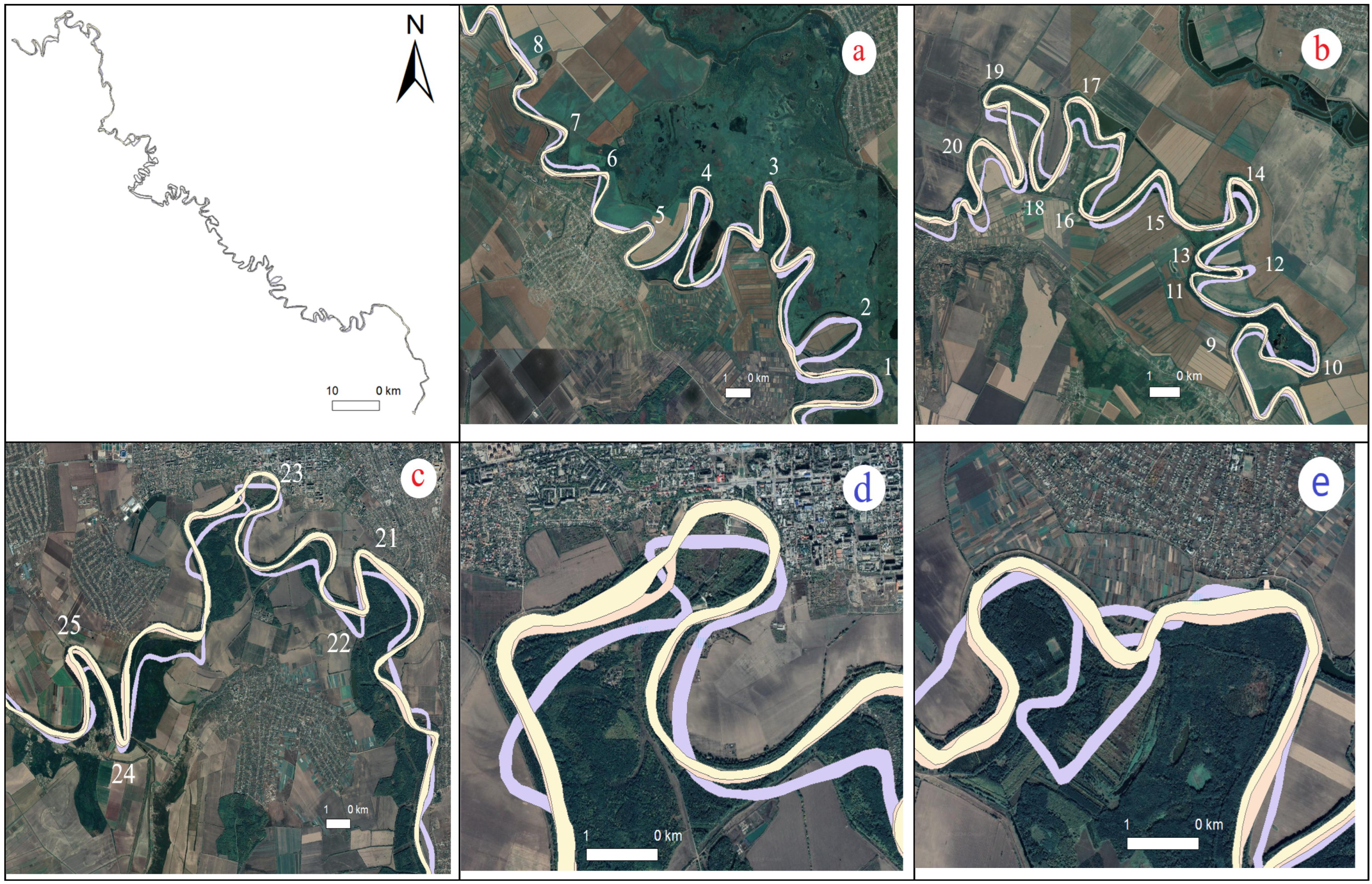
The meandering of the Lower Dniester fundamentally differs from the meandering of the middle part of the Dniester [37], where it is almost impossible to distinguish meanders for which the right and left parts of the meander are almost identical. [26,41]. The height and width of the meander (left and right) are almost the same, making it easy to establish the relationship between the parameters responsible for the meander shape and its change. In the Lower Dniester, meanders have such diverse forms (see Figure 6), ranging from a smooth left side to a sharp-angled right side; a smooth meander transitions into a box-shaped or hybrid one, where one part of the meander has a smooth shape while the other part has a box-like shape. An unusual phenomenon compared to the plain part of the river is the finger-like meanders with significant height, a non-smooth, jagged top, and lacking the typical lower bend. Some box-shaped meanders have a straight-line form on two sides, such as the lower and lateral sides.

Figure 6.
Selected meanders for research (a–e).
The floodplain in the study area is composed of cohesive clay deposits [34], which, according to the authors, significantly reduce the intensity of channel deformations and contribute to the development of new free bends in the Lower Dniester with specific shape: “finger-shaped” meanders.
Figure 6 illustrates characteristic types of meanders in the Lower Dniester region, as depicted on topographic maps from 1880 to 1980 and a satellite image from 2020. These include sinusoidal, omega-shaped, box-shaped, and finger-shaped meanders. Visual analysis reveals the complex nature of these meanders in many sections of the Lower Dniester, characterized by the combination of multiple meander forms within a single bend. The meanders of the sections (Figure 6b,c) are especially different, for instance, a meander composed of sinusoidal and box-shaped forms with sharp channel bends (point 19) or transitioning from an oval-shaped to a finger-shaped meander (point 14). Changes in channel forms from box shaped (1880) to sinusoidal (1980) and vice versa are observed in fragments shown in Figure 6d,e (points 22 and 23). The interpretation of meander form changes remains contentious in the literature, with some authors favoring lithological factors, while others emphasize the tectonic characteristics of the area.
For measuring meander characteristics, the same program tool in QGIS 3.24.1 software was employed for river displacement measurements previously. Temporal changes for 25 meanders were studied.
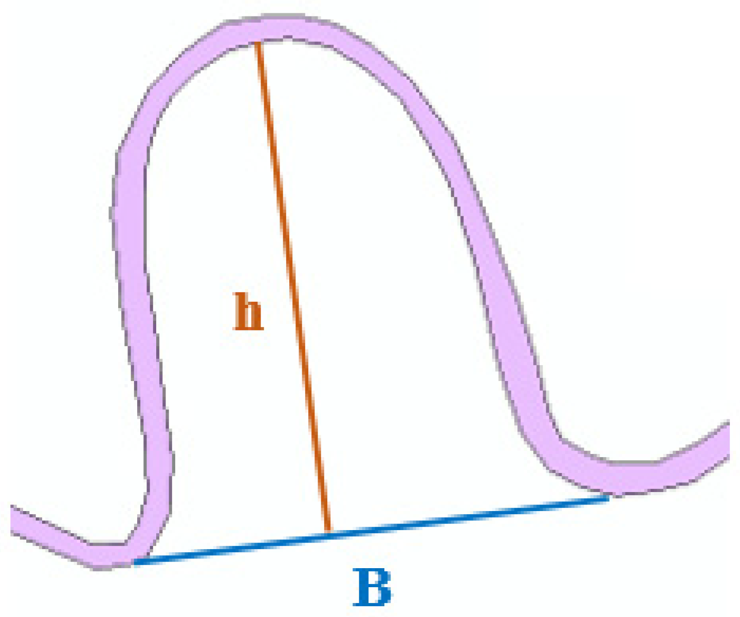
For all meanders, the base (B) connecting adjacent points on the river bends and h, the distance from the base to the highest point of the meander, were measured (Figure 7).
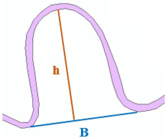
Figure 7.
Example of meander characteristics measurement.
On this section of the Dniester River, the following main types of meanders were identified: box shaped, sinusoidal, finger shaped, and hybrid (Figure 8). The activation of deformations is primarily associated with the development of secondary bends at their edges.
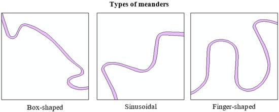
Figure 8.
Types of meanders examples.
Studying meanders is complex due to the influence of various factors. However, it is necessary to identify, as the main cause, the change in the direction of channel flows due to the tectonic fracturing of bedrock [42] or the actions of lithological processes, which are associated with the finger-shaped characteristic of meanders.
Measurements were conducted for digitized sections of the riverbed using maps and images from 1880, 1980, and 2020. The data were entered into Table 3, which provides the type of meander and its h/B ratio. Sinusoidal meanders are more common in plain rivers and are characteristic of free meandering. Box-shaped meanders [43] indicate tectonic changes in the study area. The characterization of meanders using the h/B ratio allows for a clear distinction of the unique nature of meanders, referred to in the literature as finger shaped, whose form depends on the types of lithological deposits. Hydrologists and geomorphologists attribute this particular feature to specific marshy deposits.
Table 3.
Types and characteristics of meanders of Dniester River.
Even a visual comparison of the Middle Dniester in its lower part and the Lower Dniester indicates significant changes in their overall patterns on topographic maps or satellite images. The main indicator of such changes is the characteristic of the meanders. While the Middle Dniester, from its origin in the mountainous to the foothill area and further to the Podillya region, exhibits a smooth flow without sharp and angular or box-shaped bends of the channel, in the lower part, there is a considerable number of meander loops with box-like shapes or highly elongated ones with sharp, angular turns of the channel. Some meander forms are complex and cannot be described by conventional characteristics: they can be sinusoidal, omega shaped, or even box shaped, having a hybrid nature where part of the meander is box shaped, while another part is oval or even sharp angled. Such meanders are called hybrid (Figure 6, points 14, 19, 21, etc.).
The ratios of characteristics of sinusoidal meanders from different periods vary slightly, within the range of 1.2–1.5. From the conducted research, it can be concluded that for finger-like meanders, the values of h/B are 2–4 times larger than those of sinusoidal ones, indicating their elongated form typical for the Lower Dniester channel. The h/B ratio for box-shaped meanders is an insufficient characteristic and does not correspond to the meander’s shape. For such meanders, a significant additional indicator may be the ratio of the length of the upper meander box line to the base c/B (Table 4).
Table 4.
Characteristics of box-shaped meanders.
The analysis of meanders in the Lower Dniester reveals their specific characteristics compared to meanders in other parts of the Middle Dniester. There has been a significant increase in the number of finger-shaped and box-shaped meanders, indicating a tectonic or lithological influence on the channel’s character.
The investigation of meander types was conducted using topographic maps from 1880 and 1980, as well as a 2020 satellite image, spanning a period of 120 years. A temporal change in meanders is noted; for instance, the box-shaped meander on the 1880 map transitions to sinusoidal and vice versa, from sinusoidal to complex sinusoidal or box-shaped. There is no consensus among experts regarding the reasons for the change in meander type: some attribute it to the influence of tectonic movements at various scales, while others point to specific lithology such as cohesive marshes.
3.3. Anthropogenic Factors
Anthropogenic factors cannot be clearly structured; however, their influence on the channel processes of the Lower Dniester is significant. The favorable warm climate and the large water artery have led to a significant population density in the territory in the 20th and 21st centuries.
When considering the impact of anthropogenic factors on the channel processes of the Lower Dniester, attention should be paid to the following circumstances: Firstly, natural meandering rivers are located in large fertile valleys, the most valuable areas for agriculture and settlements, so such rivers often experience demographic and economic pressures. An important area of application of channel process theory is agriculture, as the richest arable lands are located on river floodplains; river activities must be taken into account when developing reclamation projects. The design of river channel regulation works and various constructions on riverbanks and within river channels should be justified by forecasts of channel displacements based on knowledge of the conditions and regularities of river channel formation. Engineering calculations can only be sufficiently justified if they take into account the direction and intensity of channel processes, their possible changes, and the specificity of manifestation in different conditions, both in their natural development and through the impact of economic measures. The economic use of rivers leads to significant changes in their hydrological regime, up to the emergence of qualitatively new channels [44].
This indicates the necessity of systematic, professional implementation of protective measures against flooding and enhanced control over coastal erosion and meander mineralization.
The impact of anthropogenic factors on the Dniester River can be explained by significant hydrotechnical works, water reclamation, and the reduction of water discharge used for various economic purposes.
The waters of the Dniester River are utilized for supplying water to many settlements and for irrigating thousands of hectares of agricultural land. Cities such as Hotyn, Mohyliv-Podilskyi, Yampol, Soroky, Kamianka, Dubossary, Bender, Slobozia, and others are situated along the Dniester. The concentrations of some pollutants are ten times higher than the permissible limits. The layout of settlements along the Dniester is shown in Figure 9.
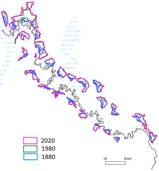
Figure 9.
Location of settlements of the Dniester.
Over 100 years, from 1880 to 1980, the area of settlements along the investigated 300 km of the Dniester River increased by 4.54 times, and another 40 years later, it increased by 5.44 times. In the adjacent territories of Ukraine and Moldova, over 7 million people reside, with over 5.0 million in the territory of Ukraine. The Dniester River water, used for drinking purposes, is consumed by 3.5 million people, including residents of Chernivtsi, Odesa, Lviv, Kamianets-Podilskyi, Chisinau, Dubossary, Tiraspol, and other smaller cities.
Agriculture and livestock farming are widely developed along the banks of the Dniester, with mining, chemical industries, and agricultural processing enterprises also situated there. Considering the favorable climatic conditions of the area, agriculture and livestock farming are well developed; however, these sectors require significant volumes of water resources.
The surface water of the Dniester River is used both to meet general water use needs and for the drinking water supply to the population, as well as for the irrigation of agricultural fields (see Figure 3c).
Within the Dniester River basin, water pollution from industrial enterprises, domestic sewage, and diffuse pollution from agricultural lands is observed. The concentrations of some pollutants exceed the maximum permissible concentrations by 10 times.
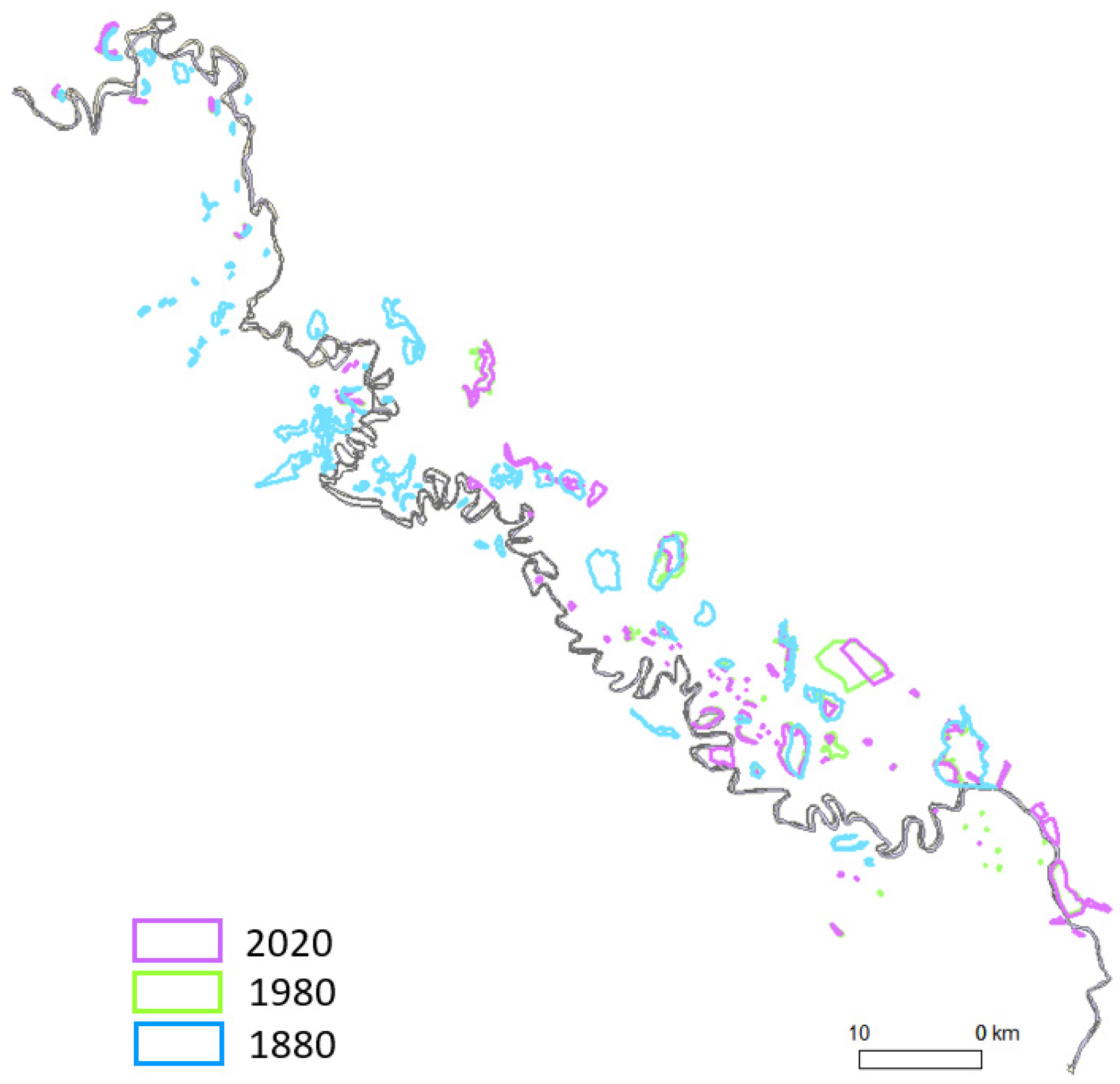
Figure 10 illustrates the change in lake areas during the study period from 1880 to 2020. Unlike the increase in the areas of populated land, lake areas have decreased.
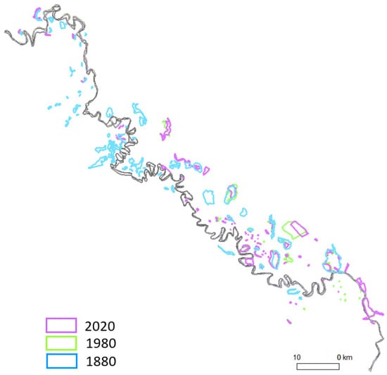
Figure 10.
Lakes at different periods of the study area.
The state of the river ecology and surrounding areas is significantly influenced by hydropower engineering. Starting from the 1950s, rivers began to be utilized as a source of hydropower. In Moldova, the Dubossary Hydroelectric Power Station (HPS) was constructed, while in Ukraine, the Dniester Cascade of HPSs was built: two powerful hydroelectric power stations, HPS-1 and HPS-2, and one hydroaccumulating power station, HAPS. Consequently, the Dubossary and Dniester (main and buffer) reservoirs were created and designed for annual regulation of the river’s flow.
A negative effect of HPSs includes the disturbance of the Dniester’s thermal regime, since water discharged from the reservoirs has a lower temperature than normal during warm periods. Figure 11 illustrates the changes in lake areas from 1880 to 2020; unlike the increase in the areas of inhabited settlements, lake areas have decreased.
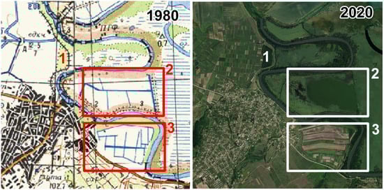
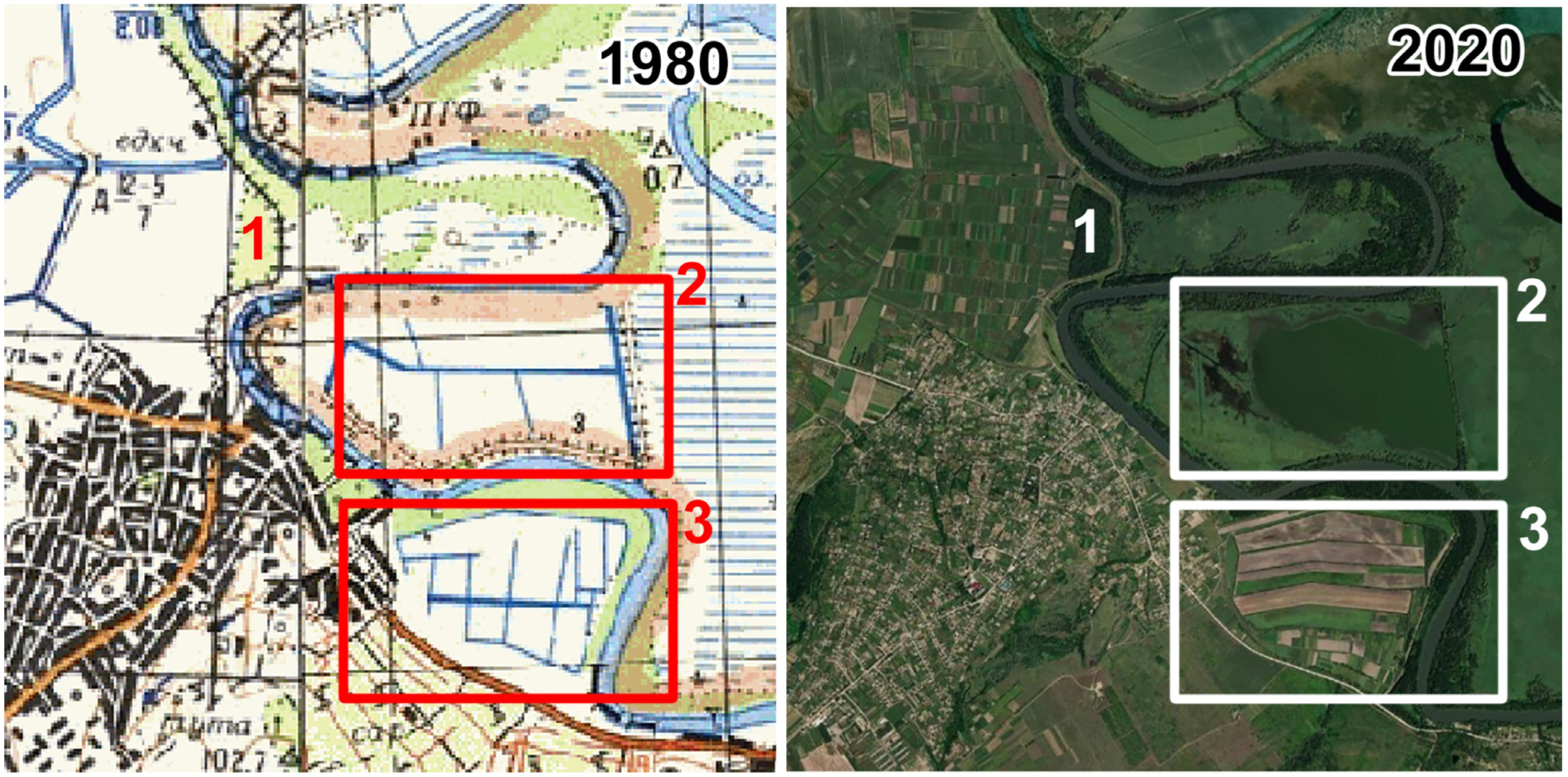
Figure 11.
Changes in the terrain as a result of the anthropogenic factor topographic map source: https://freemap.com.ua/, accessed on 10 February 2023, orthophoto source: ESRI, Maxar; 1—artificial embankments; 2—drainage channels on the 1980 map, where a pond was formed; 3—drainage canals on the map of 1980, in place of which are now fields.
Compared to 1880, over 140 years, the area of lakes has decreased by 55% (Table 5).
Table 5.
Measured areas of lakes.
Significant hydraulic and reclamation transformations are evidenced in Figure 11, which illustrates changes in a portion of the territory in images from 1980 and 2020. The dashed line indicates the border between Ukraine and Moldova, following the river fairway; 1, artificial embankments for stabilizing the shoreline; 2, on the 1980 map, these are drainage and irrigation canals, while in the image, it shows a formed lake; 3, drainage canals on the map, and in the 2020 image, these are already cultivated fields. Such changes are observed throughout the Transnistrian territory.
Figure 11 depicts features along the border between Ukraine and Moldova on the map and satellite image as follows: 1, protective artificial embankments; 2, drainage canals on the 1980 map, which have now formed into a pond in the satellite image; 3, on the map, drainage canals are shown, whereas on the satellite image, agricultural fields are now present in their place.
The Dniester Lowlands, particularly the area where the Dniester merges with the Turunchuk, are listed in the international Ramsar Convention for the protection of wetlands. In the Odesa region, a reservoir called the “Dnistrovski Plavni” has been created within the floodplains and reedbeds. The Dniester Delta is a nesting ground for many bird species, and it hosts numerous rare plant species.
4. Discussion
In recent decades, geomorphological studies have increasingly been used to address various scientific and economic challenges. They are effective in assessing flood risks, developing and implementing various technical projects, as well as projects for sustainable restoration, and introducing effective measures for protecting and enhancing the biodiversity of freshwater ecosystems. Building bridges, water intake systems, embankments, and other constructions requires careful consideration of channel processes. These structures modify the river flow conditions and lead to various new phenomena that affect channel formation. It is crucial to anticipate these changes to preserve and maintain the functionality of the structure.
Since each river is studied individually, which is related to the influence of channel processes by both natural and anthropogenic factors, the scope of such studies is quite broad and has its peculiarities for each river.
Based on the conducted research characterizing the channel processes of the Lower Dniester, a conclusion was drawn regarding the influence of the geological structure and tectonics of the territory. The proposed approach suggests using characteristics corresponding to the shapes of bends for analyzing different types of meanders. In the lower part of the Dniester, unlike other parts of the river, a significant number of meanders have a box-shaped and finger-shaped form, and a considerable number of meanders, termed hybrid, combine the forms of different meanders. Such a characteristic of meanders indicates the tectonic nature of the territory and the specificity of the action of lithological structures. The comparative analysis of the meanders in different parts of the Dniester River are the task for future research considering the characteristics, numbers, and types of meanders as well as the influence of tectonics.
Horizontal displacements of riverbeds characterize the stability of the riverbed, which largely depends on the geological structures through which the river flows, i.e., on the interaction of the water flow with the riverbed, and the influence of anthropogenic factors on the riverbed and adjacent areas. To study horizontal displacements of riverbeds, a topographic map from 1980 and a satellite image obtained from the Sentinel 2 satellite in 2020 were used. Horizontal displacements of riverbeds were measured at 76 points located at characteristic bends of the river. Digitized images of the 1980 map and the satellite image obtained from the Sentinel 2 in 2020 were considered for their analysis.
The determination of riverbed displacements from 1980 to 2020 was carried out using a previously established coordinate system, which ranges from 20 to 25 m. The majority of horizontal displacements of riverbeds (up to 80 percent) range up to 100 m, indicating the sufficiently stable nature of the river. When obtaining data on the course of the riverbed from archive material, one should proceed very carefully. Topographic maps at a scale of 1:126,000 from 1880 and maps at a scale of 1:100,000 from 1980 provide valuable thematic information for the analyses carried out despite acceptable results of geometric transformation, but they are characterized by lower geometric accuracy in determining the actual location of the riverbed. The whole process of obtaining data from these maps, especially the identification of tie points for the transformation, can significantly affect the results obtained. Therefore, it is important that the number of tie points is appropriate and that their position on the different source data (time series) is controlled.
5. Conclusions
Taking into account the results of the research carried out, the final conclusions are as follows:
- The methodology for monitoring channel processes over a long period has undergone significant changes due to modern approaches that are based on the use of topographic maps from various temporal periods, satellite images of different resolutions, and GIS technologies for data processing.
- The monitoring of channel processes in the Lower Dniester was conducted based on the utilization of tectonic maps of the region, historical topographic maps, and satellite imagery. It involved identifying meander types, their characteristics and changes, plain riverbed displacements, and the impacts of anthropogenic factors on channel processes.
- The construction of bridge crossings, water intakes, embankments, and other structures cannot be carried out without considering the influence of channel processes. Such structures alter the conditions of river flow and trigger a series of new phenomena in the activity that shapes the channel and must be anticipated to ensure the preservation and functioning of the structure itself.
- The determination of riverbed displacements from 1980 to 2020 was carried out using a previously established coordinate system, which ranges from 20 to 25 m. The majority of horizontal displacements of riverbeds (up to 80 percent) range up to 100 m, indicating the sufficiently stable nature of the river.
- For the purpose of studying the types of meanders in the Dniester River and conducting their analysis, it is proposed to use characteristics of meanders and their relationships. This approach will allow for more efficient analysis and prediction of changes in channel processes under the influence of natural and anthropogenic factors across various temporal scales.
- As research conducted on the Lower Dniester has shown, this region significantly differs from the Middle Dniester, primarily due to its location on the Prydnistrovska monocline, influenced by the tectonics of internal structures and the seismically active Vrancea zone in Romania. This circumstance, along with the rugged surface, may affect the type of meanders, characterized by box-shaped and hybrid structures, indicating a significant influence of tectonic processes on the riverbed.
- An interesting manifestation of channel processes and lithological features of the Lower Dniester territory is the presence of finger-shaped meanders, the change in elongated forms of which is significantly dependent on temporal variations compared to other types of meanders. This type of meander is influenced by the lithology of the area, particularly the formation of cohesive marsh enclaves.
- Comparing maps from 1880, 1980, and a satellite image from 2020 of the riparian area of the Lower Dniester, it is possible to assess how the territory has changed under the influence of anthropogenic factors. In the first, we see a continuous marsh and lakes; in the second, we see the results of land reclamation, shoreline protection, and the presence of reservoirs; and in the third, with a time gap of 140 years from the first map, we observe intensive agricultural activities.
Author Contributions
Conceptualization, K.B. (Khrystyna Burshtynska), N.H. and I.Z.; methodology, K.B. (Khrystyna Burshtynska); software, N.H. and L.B.; validation, I.Z., A.F. and L.B.; formal analysis, L.B. and A.F.; investigation, N.H and I.Z.; resources, K.B. (Khrystyna Burshtynska) and N.H.; data curation, K.B. (Khrystyna Burshtynska) and I.Z.; writing—original draft preparation, K.B. (Khrystyna Burshtynska), K.B. (Krzysztof Bakuła), I.Z., L.B. and A.F.; writing—review and editing, K.B. (Krzysztof Bakuła), I.Z.; visualization, N.H; supervision, K.B. (Khrystyna Burshtynska); project administration, K.B. (Khrystyna Burshtynska) and K.B. (Krzysztof Bakuła); funding acquisition, K.B. (Krzysztof Bakuła). All authors have read and agreed to the published version of the manuscript.
Funding
The APC was funded by the Polish National Agency for Academic Exchange within the project “Development of strategic cooperation between Warsaw University of Technology and Lviv Polytechnic National University in the field of geomatics” agreement number BPI/PST/2021/1/00044/U/00001.
Data Availability Statement
Data are unavailable due to privacy and ethical restrictions.
Conflicts of Interest
The authors declare no conflict of interest. The funders had no role in the design of the study; in the collection, analyses, or interpretation of data; in the writing of the manuscript; or in the decision to publish the results.
References
- EU Biodiversity Strategy for 2030 “Bringing Nature Back into Our Lives” Communication from the Commission to the European Parliament, the Council, The European Economic and Social Committee and the Committee of the Regions, European Commission, Directorate-General for Environment, Document 52020DC0380, COM/2020/380 Final. Available online: https://eur-lex.europa.eu/legal-content/EN/TXT/?uri=celex%3A52020DC0380 (accessed on 1 February 2024).
- The Rio Declaration on Environment and Development. Available online: https://www.iau-hesd.net/sites/default/files/media_files/rio_e.pdf (accessed on 20 December 2022).
- ISOK (Informatyczny System Osłony Kraju Przed Nadzwyczajnymi Zagrożeniami). Electronic Resource. Available online: https://isok.gov.pl/index.html (accessed on 25 December 2022).
- Shevchuk, V.; Burshtynska, K.; Korolik, I.; Halochkin, M. Monitoring of horizontal displacements and changes of the riverine area of the Dniester River. J. Water Land. Dev. 2021, 49, 1–15. [Google Scholar] [CrossRef]
- Kiedrzyńska, E.; Kiedrzyński, M.; Zalewski, M. Sustainable floodplain management for flood prevention and water quality improvement. Nat. Hazards 2015, 76, 955–977. [Google Scholar] [CrossRef]
- Grizzetti, B.; Liquete, C.; Pistocchi, A.; Vigiak, O.; Zulian, G.; Bouraoui, F.; De Roo, A.; Cardoso, A.C. Relationship between ecological condition and ecosystem services in European rivers, lakes and coastal waters. Sci. Total Environ. 2019, 671, 452–465. [Google Scholar] [CrossRef] [PubMed]
- Popov, I.V. Deformations of river channels and hydraulic engineering construction. In Hydrological and Morphological Theory of Channel Process and Its Application; Hydrometeorological Publishing House: Leningrad, Russia, 1965; p. 328. [Google Scholar]
- Brown, A.G.; Lespez, L.; Sear, D.A.; Macaire, J.J.; Houben, P.; Klimek, K.; Brazier, R.E.; Van Oost, K.; Pears, B. Natural vs anthropogenic streams in Europe: History, ecology and implications for restoration, river-rewilding and riverine ecosystem services. Earth-Sci. Rev. 2018, 180, 185–205. [Google Scholar] [CrossRef]
- Piégay, H.; Arnaud, F.; Belletti, B.; Bertrand, M.; Bizzi, S.; Carbonneau, P.; Dufour, S.; Liébault, F.; Ruiz-Villanueva, V.; Slater, L. Remotely sensed rivers in the Anthropocene: State of the art and prospects. Earth Surf. Process. Landf. 2020, 45, 157–188. [Google Scholar] [CrossRef]
- Cavallo, C.; Nones, M.; Papa, M.N.; Gargiulo, M.; Ruello, G. Monitoring the morphological evolution of a reach of the Italian Po River using multispectral satellite imagery and stage data. Geocarto Int. 2022, 37, 8579–8601. [Google Scholar] [CrossRef]
- Burshtynska, K.; Zayats, I.; Halochkin, M.; Bakula, K.; Babiy, L. The Influence of the Main Factors on the Accuracy of Hydrological Modelling of Flooded Lands. Water 2023, 15, 3303. [Google Scholar] [CrossRef]
- Kravchuk, Y.; Zinko, Y.; Hnatiuk, R.; Moskaliuk, K. Evaluation of geodiversity of geomorphological regions of upper and middle dniester. In Problems of Geomor-Phology and Palaeogeography of the Ukrainian Carpathians and Adjacent Territories; Ivan Franko National University Of Lviv: Lviv, Ukraine, 2016; Volume 1, pp. 275–290. Available online: http://nbuv.gov.ua/UJRN/prgeomorpal_2016_1_25 (accessed on 10 February 2023).
- Zayats, I.; Tretiak, S.; Radziy, I. Investigation of the Dniester River bed displacements by means of GIS technologies. Mod. Achiev. Geod. Sci. Prod. 2018, 36, 106–114. [Google Scholar]
- Burshtynska, K.V.; Babushka, A.; Bubniak, I.; Babiy, L.; Tretyak, S. Influence of geological structures on the nature of riverbed displacements for the rivers of the Dniester basin upper part. Geodynamics 2019, 2, 24–38. [Google Scholar] [CrossRef]
- Burshtynska, K.; Kokhan, S.; Pfeifer, N.; Halochkin, M.; Zayats, I. Hydrological Modeling for Determining Flooded Land from Unmanned Aerial Vehicle Images—Case Study at the Dniester River. Remote Sens. 2023, 15, 1071. [Google Scholar] [CrossRef]
- Nones, M.; Di Silvio, G. Modeling of river width variations based on hydrological, morphological, and biological dynamics. J. Hydraul. Eng. 2016, 142, 04016012. [Google Scholar] [CrossRef]
- Vaughan, I.P.; Ormerod, S.J. Linking ecological and hydromorphological data: Approaches, challenges and future prospects for riverine science. Aquat. Conserv. Mar. Freshw. Ecosyst. 2010, 20, S125–S130. [Google Scholar] [CrossRef]
- Beighley, R.E.; Eggert, K.G.; Dunne, T.; He, Y.; Gummadi, V.; Verdin, K.L. Simulating hydrologic and hydraulic processes throughout the Amazon River Basin. Hydrol. Process. 2009, 23, 1221–1235. Available online: https://www.scribd.com/document/353754346/Beighley-Eggert-Etal-2009 (accessed on 1 February 2023). [CrossRef]
- Buffington, J.M.; Montgomery, D.R. Geomorphic classification of rivers. Treatise Geomorphol. Fluv. Geomorphol. 2013, 9, 730–767. [Google Scholar] [CrossRef]
- Buffington, J.M.; Woodsmith, R.D.; Booth, D.B.; Montgomery, D.R. Fluvial Processes in Puget Sound Rivers and the Pacific Northwest. Restoration of Puget Sound Rivers; University of Washington Press: Seattle, WA, USA, 2023; pp. 46–78. Available online: https://www.fs.usda.gov/research/treesearch/20445 (accessed on 1 February 2023).
- Gorbachova, L.O. Modern priorities and directions of hydroecological research in river basins. Hydrol. Hydrochem. Hydroecol. 2006, 11, 338–341. [Google Scholar]
- Krzemień, K. Studies on the structure and dynamics of the Carpathian river channels. In Infrastruktura i Ekologia Terenów Wiejskich (Infrastructure and Ecology of Rural Areas); Commission of Technical Infrastructure of the Polish Academy of Sciences: Cracow, Poland, 2006; Volume 4, pp. 131–142. [Google Scholar]
- Arnaud-Fassetta, G. River channel changes in the Rhone Delta (France) since the end of the Little Ice Age: Geomorphological adjustment to hydroclimatic change and natural resource management. Catena 2003, 51, 141–172. [Google Scholar] [CrossRef]
- Antonelli, C.; Provansal, M.; Vella, C. Recent morphological channel changes in a deltaïc environment. The case of the Rhône River, France. Geomorphology 2004, 57, 385–402. [Google Scholar] [CrossRef]
- Provansal, M.; Pichard, G.; Anthony, E.J. Geomorphic Changes in the Rhône Delta During the LIA: Input from the Analysis of Ancient Maps. In Sediment Fluxes in Coastal Areas; Coastal Research Library; Maanan, M., Robin, M., Eds.; Springer: Dordrecht, The Netherlands, 2015; Volume 10. [Google Scholar] [CrossRef]
- Chalov, R.S.; Zavadsky, A.S.; Panin, A.V. River Bends; Scientific editor; MSU Publishing House: Moscow, Russia, 2004; p. 371. [Google Scholar]
- Chalov, R.S. Channel science: Theory, geography, practice. In Channel Processes: Factors, Mechanisms, Forms of Manifestation and Conditions of River Channel Formation; LKI: Malyn, Ukraine, 2008; Volume 1, p. 608. [Google Scholar]
- Lokhtin, V.M. The Dniester River, Its Shipping, Properties and Improvement; A. Schilze Printing House: Odessa, Ukraine, 1886; p. 119. [Google Scholar]
- Popov, I.V. Methodological bases of hydromorphological theory of channel process. In Selected Works; NestorHistory Publishing House: Saint-Petersburg, Russia, 2012; p. 304. [Google Scholar]
- Gerenchuk, K.I. Tectonic Regularities in Orography and River Network of the Russian Plain; Lviv University Press: Lviv Oblast, Ukraine, 1960; p. 242. [Google Scholar]
- Obodovskyi, O.G. Hydrological and Ecological Assessment of Riverbed Processes (on the Example of Rivers of Ukraine); Nika-Centre: Kyiv, Ukraine, 2001; p. 274. [Google Scholar]
- Kovalchuk, I.P. Topical issues of dynamic geomorphology of the Ukrainian Carpathians. In Problems of Geomorphology and Paleogeography of the Ukrainian Carpathians and Adjacent Territories; Ivan Franko National University Of Lviv: Lviv, Ukraine, 2014; pp. 89–97. Available online: http://nbuv.gov.ua/UJRN/prgeomorpal_2014_2014_13 (accessed on 12 December 2022).
- Kovalchuk, I.P. Hydrological and Geomorphological Processes in the Carpathian Region of Ukraine. Works of the Shevchen-ko Scientific Society. VOL. XII: Ecological Collection. Ecological Problems of the Carpathian Region. pp. 101–125. Available online: http://dspace.nbuv.gov.ua/handle/123456789/73587 (accessed on 15 September 2023).
- Bukatchuk, P.D.; Burdenko, B.V. On the nature of the Dniester bends within the middle and lower courses of the Dniester. Rep. USSR Acad. Sci. 1967, 172, 60–88. [Google Scholar]
- Macarescu, V.S. The role of Pliocene-Quaternary faults in the formation of incised meanders in the middle and lower reaches of the Dniester River. In Tectonics and Seismicity of the Black Sea Region and the Black Sea Depression; Shtiintsa: Kishinev, Moldova, 1974; pp. 136–145. [Google Scholar]
- Topal, S. Geomorphological responses of rivers to active tectonics along the Karahayıt Fault, Western Türkiye. J. Mt. Sci. 2024, 21, 1464–1474. [Google Scholar] [CrossRef]
- Burshtynska, K.; Zayats, I.; Tretyak, S.; Halochkin, M. Monitoring of the riverbed of river Dniester of the Carpathian Region using GIS technologies. Arch. Photogramm. Cartogr. Remote Sens. 2017, 29, 25–36. [Google Scholar] [CrossRef]
- Shevchuk, V.M. Methodology for studying changes in riverbed deformation in the Carpathian region. Geod. Cartogr. Aer. Surv. 2009, 71, 59–69. [Google Scholar]
- Palijenko, V.P. Reflection of the dynamics of the basement blocks in the latest tectonics and modern relief. In Geotectonics of Volyno-Podolia; Nauk. Dumka: Kyiv, Ukraine, 1990; pp. 203–209. [Google Scholar]
- Hintov, O.V.; Murovskaya, A.V.; Egorova, T.P.; Wolfman, Y.M.; Tsvetkova, T.A.; Vugaenko, I.V.; Kolesnikova, E.Y.; Ostrovnoy, A.N.; Vubnyak, I.N.; Farfulyak, L.V.; et al. Vrancea deep seismogenic zone as an indicator of geodynamic process. Geophys. J. 2015, 37, 22–49. Available online: http://dspace.nbuv.gov.ua/handle/123456789/103675 (accessed on 20 March 2024).
- Zolezzi, G.; Luchi, R.; Tubino, M. Modelling morphodynamic processes in meandering rivers with spatial width variations. Rev. Geophys. 2012, 50, RG4005. [Google Scholar] [CrossRef]
- Svynko, I.M. On tectonic fracturing of rocks of the western part of Podolia. Geol. Collect. Lviv Soc. 1973, 14, 64–66. [Google Scholar]
- Pavlovska, T.S. Geomorphology. Textbook; Kovalchuk, I.P., Ed.; Lesya Ukrainka Volyn National University: Lutsk, Ukraine, 2009; p. 284. [Google Scholar]
- Afremov, D.N. Anthropogenic influences on the formation of the longitudinal profile of the Dniester River. Izvestiya AS USSR. Ser. Geograf. 1969, 3, 39–43. [Google Scholar]


Disclaimer/Publisher’s Note: The statements, opinions and data contained in all publications are solely those of the individual author(s) and contributor(s) and not of MDPI and/or the editor(s). MDPI and/or the editor(s) disclaim responsibility for any injury to people or property resulting from any ideas, methods, instructions or products referred to in the content. |
© 2024 by the authors. Licensee MDPI, Basel, Switzerland. This article is an open access article distributed under the terms and conditions of the Creative Commons Attribution (CC BY) license (https://creativecommons.org/licenses/by/4.0/).