
Research Hotspots and Trends in the Environment Condition of the Yellow River Basin (2014–2024): A Bibliometric and Visualization

Abstract
:1. Introduction
2. Materials and Methods
2.1. Data Source
2.2. Statistical Analysis and Visualization
3. Results
3.1. Publication Characteristics
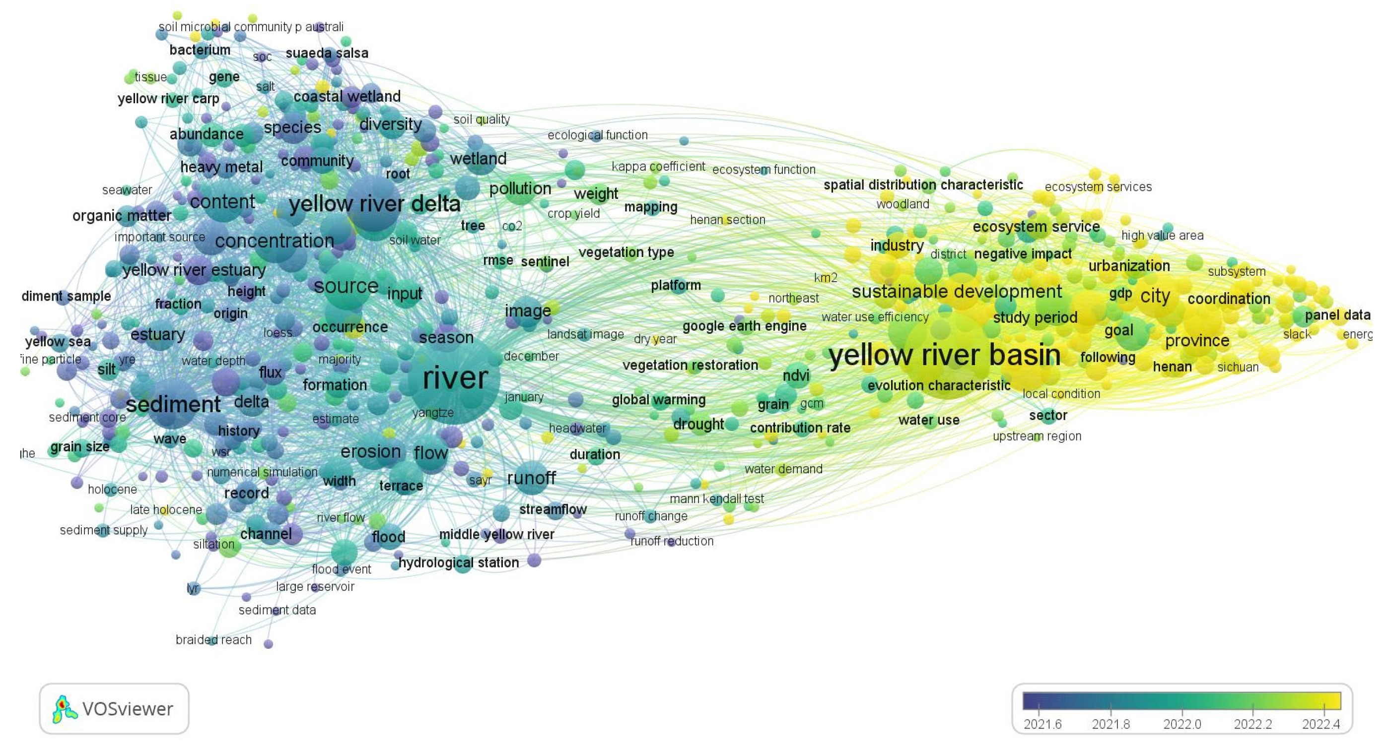
3.2. Keyword Co-Occurrence Analysis
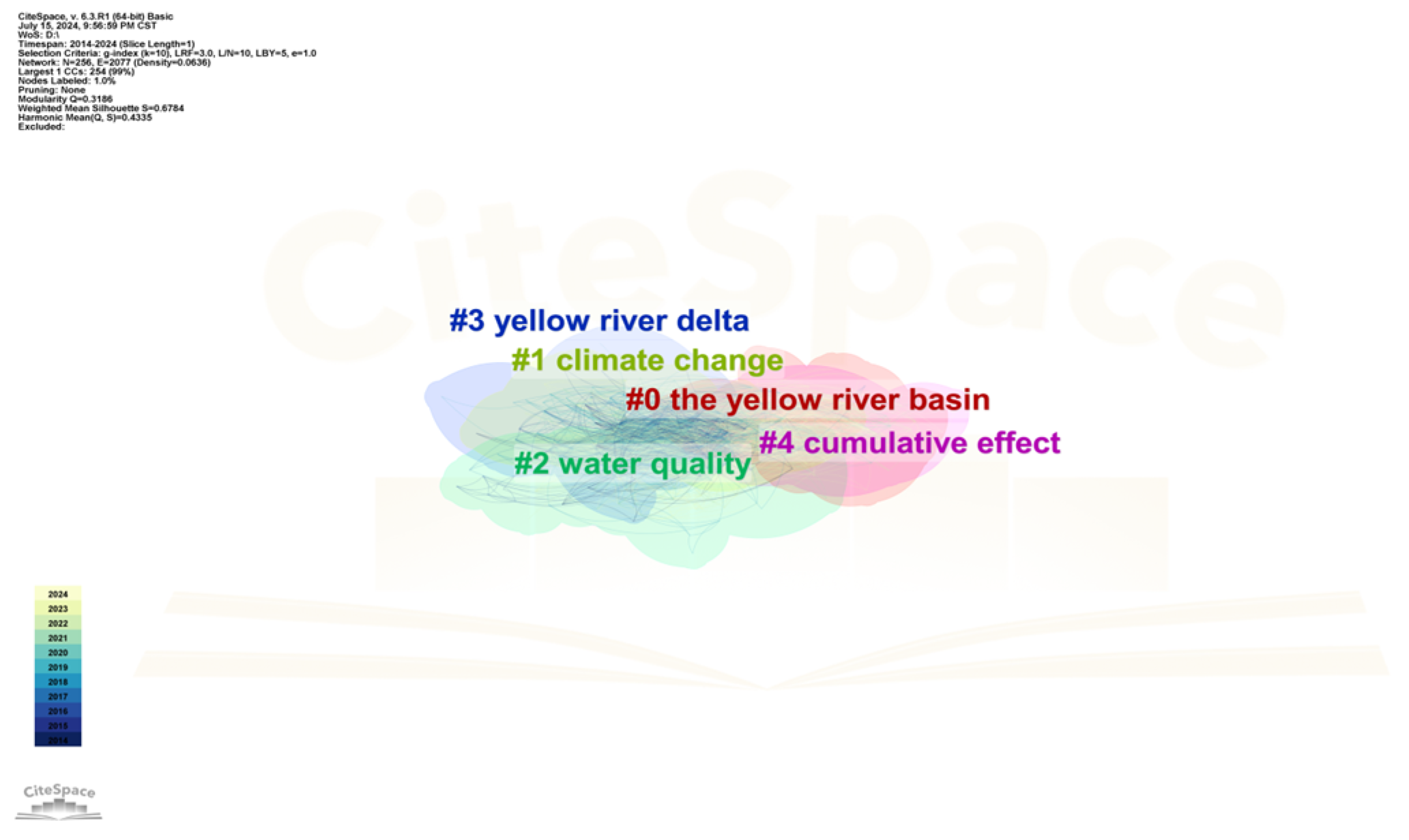
3.3. Keyword Cluster Analysis
3.3.1. Keyword Clustering 0# Analysis
- 0# This category of papers primarily focuses on the ecological environment of the Yellow River Basin. Researchers in this category are concerned with improving habitat quality in the basin, identifying key factors that impact the ecological environment, establishing investment models that are friendly to the environment, and utilizing the ecological services of the Yellow River Basin for human benefit. Given the vastness of the Yellow River Basin, Zhao [7], using habitat management in the Yellow River floodplain as an example, found that arable land and construction land are important components of the floodplain, but the habitat quality is relatively low. In contrast, ecological land (such as forests, grasslands, and water bodies) significantly contributes to habitat quality, providing valuable insights for enhancing habitat quality in the Yellow River Basin. Dong [8] investigated the habitat changes and influencing factors in the Loess Plateau region of the Yellow River basin, where the ecological environment is relatively fragile. Additionally, rapid industrialization and urbanization in China have led to the most severe habitat degradation in this region. His research found that the spatial distribution of habitat quality exhibits a gradient from high at the periphery to low in the center and shows significant spatial autocorrelation. Topographic relief and slope are identified as key factors. These findings provide a scientific basis for land resource utilization and ecosystem restoration in the Loess Plateau region. Previous studies have divided the vast Yellow River Basin into different regions and achieved significant research results. These findings may provide a foundation for future improvements in habitat quality across the entire Yellow River Basin [9,10,11,12,13]. Soil erosion in the Yellow River Basin has long impacted the high-quality development of the surrounding areas [14,15,16]. Industrial structure upgrading is one approach to mitigating soil erosion problems and improving habitat quality in the basin. Li [17] utilized the entropy weight method, InVEST model, and fixed-space Durbin model to explore the impacts of industrial greening, industrial structure upgrading, and rationalization of industrial distribution on average soil and water conservation. The study found that all three factors—industrial greening, upgrading of industrial structure, and rationalization of industrial distribution—contribute to an overall improvement in average soil and water conservation rates, although their effectiveness varies. These findings provide valuable references for government agencies and investors; The Grain-for-Green policy, during its first phase from 2000 to 2015 and its second phase from 2015 to 2020, increased the carbon stock in the Yellow River basin by 2.87 × 10⁸ tons and 2.15 × 10⁸ tons, respectively. Since the implementation of this policy, vegetation cover in the Loess Plateau region has greatly improved, and the overall erosion intensity of the basin has been reduced to a slight level. However, despite the significant overall improvement, erosion issues in some grasslands and forest areas persist and require further attention and management as follows:
- To effectively utilize the ecological services of the Yellow River Basin, Wu first evaluated and compared the ecosystem service values between the Yellow River Basin and the Yangtze River Basin. The evaluation included provisioning services, regulating services, and cultural services, with additional analysis incorporating economic indicators. The results indicate that the spatial distribution of ecosystem service values is similar in both basins, with higher values in the upstream (west), lower values in the downstream (east), and intermediate values in the central region. However, the annual total ecosystem service value of the Yangtze River Basin is over three times that of the Yellow River Basin. Moreover, most counties in both basins face issues where ecosystem service values are not fully utilized [18]. Li’s research may lay the groundwork for spatial planning and high-quality development pathways in key river basins in China. The Yellow River Basin, as an ecological barrier within the region, plays a crucial role in providing essential ecosystem services [19,20,21]. Analyzing the ecosystem service value (ESV) of the YRSAs is crucial for raising ecological protection awareness and promoting ecological actions. Yang’s [22] study, based on land use changes and equivalent factor methods, revealed the spatiotemporal characteristics of ESV in the YRSAs from 2000 to 2020. The study used geographic detectors to explore the driving mechanisms of ESV heterogeneity. The findings indicate a significant increase in ESV in the Yellow River Basin, with an average increase rate of 9.12 × 10²¹ seJ/5a. The spatial distribution shows lower values in the northwest and higher values in the southeast, although this imbalance is gradually diminishing. Climate factors are identified as the primary drivers of ESV spatial heterogeneity, highlighting the sensitivity of YRSAs to climate change. Additionally, the results underscore the indispensable role of the ecological security system in assessing ESV in the Yellow River Basin, providing theoretical support and references for decision-makers evaluating the ecological security of the ecological barrier.
3.3.2. Keyword Clustering 1# Analysis
- 1# This group of papers mainly explores the impact of the climate on the Yellow River Basin. Climate change affects regional precipitation, which in turn influences Yellow River runoff. Changes in rainfall also impact soil erosion, thereby altering sediment load in the Yellow River. Human activities also affect runoff in the basin, and changes brought about by climate change can subsequently alter human activities. Han [23], based on annual average temperature and total precipitation records from 70 meteorological stations between 1961 and 2020, used the Mann–Kendall (M–K) test and bivariate wavelet analysis to study the effects of climate change on natural runoff in the Yellow River Basin. The results indicated a gradual increase in average temperature from 1961 to 2020. The M–K test results showed that the reduction in natural runoff was closely related to increases in temperature (and decreases in precipitation). However, bivariate wavelet coherence analysis further revealed that the ongoing decrease in natural runoff was primarily due to reduced precipitation rather than rising temperatures. Chen’s [24] research reached similar conclusions. This finding provides crucial scientific evidence for optimizing water resource allocation in arid and semi-arid regions under the context of climate change.
- As the world’s largest sandy river, the Yellow River has an annual sediment transport capacity of about 1.6 billion tons. Increasing attention is being given to the water resource supply and soil erosion in this basin, especially under the impact of climate change. Yu [25] employed a distributed hydrological model, specifically the Soil and Water Assessment Tool (SWAT), to quantify the response of runoff and sediment discharge in the Yellow River Basin to climate change. The study found that with decreasing precipitation and rising temperatures, annual runoff and sediment yield have significantly declined, with precipitation being the dominant factor. Future projections indicate a continued decrease in sediment yield, particularly in late summer and early autumn. Due to excessive natural resource exploitation, ecological degradation, and rapid urbanization, the Yellow River Basin in China has experienced significant land use and land cover changes (LUCC), which play a crucial role in regional climate. Ru [26] utilized land use and land cover (LULC) data and made future climate projections under two shared socioeconomic pathways (SSP245 and SSP585). In the SSP245 scenario, precipitation is projected to increase by 32.21 mm, while in the SSP585 scenario, it is projected to rise by 134.24 mm. Additionally, both the forest and urban areas significantly influence precipitation under both scenarios. The study highlights the significant role of land use in precipitation changes under different development scenarios in the Yellow River Basin, offering valuable insights for effectively addressing climate issues in the region. Wang [27] utilized seven global climate models (GCMs) to predict future climate patterns for parts of the Yellow River Basin. The trend indicates a rise in temperatures in the future, which may exacerbate existing issues related to domestic water demand and potentially lead to intensified competition among various water usage sectors.
3.3.3. Keyword Clustering 2# Analysis
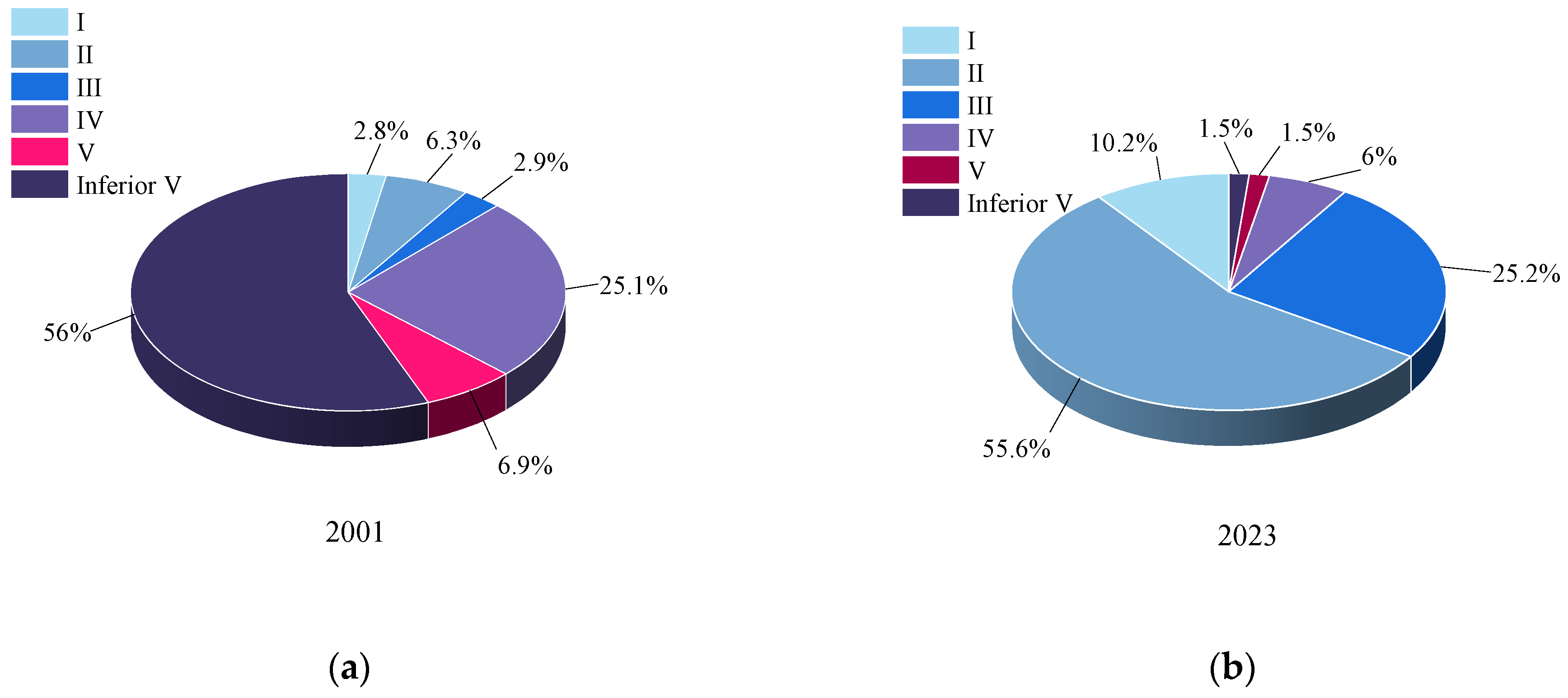
- 2# This group of papers focuses on the water quality in the Yellow River Basin. Using data from government reports, the “Environmental Status Bulletin”, we employed statistical methods to analyze changes in the water quality, pollutant indicators, and remediation effects from 2001 to 2023. According to the data from the “Environmental Bulletin,” monitoring results from 175 sections in the Yellow River Basin in 2001 showed the following distribution of water quality grades: 2.8% for Grade I, 3.6% for Grade II, 2.9% for Grade III, 25.1% for Grade IV, 6.9% for Grade V, and 56.0% for Inferior V. As shown in Figure 5a, more than half of the water quality was classified as Grade V, indicating severe pollution in 2001. By 2023, results from 137 monitoring sections showed the following distribution: 10.2% for Grade I, 55.6% for Grade II, 25.2% for Grade III, 6% for Grade IV, 1.5% for Grade V, and 1.5% for Inferior V, as shown in Figure 5b. The majority of the water was classified as Grade II, with no Inferior V water recorded. In 2001, the proportions of Grade I–III, Grade IV–V, and Inferior V waters were 12.0%, 32.0%, and 56.0%, respectively. By 2023, these proportions changed to 92%, 7.5%, and 1.5%. Over the past decade, the amount of Grade I–III water increased by 72.7%, while Grade IV–V and Inferior V water decreased by 16.7% and 56.0%, respectively.
- Human activities can have both positive and negative impacts on water quality. The changes of water quality in the Yellow River Basin from 2001 to 2023 are shown in Figure 6. Given the complex geographical environment of river basins and the top-down environmental management system in China, the country has introduced the River Chief System, which is unique to China. Zhang [28], using the Yellow River Basin as a case study, focused on the implementation of the River Chief System and examined whether it contributed to improving water quality in the Yellow River Basin. The study also collected and analyzed water quality classification data for river sections, main rivers, major tributaries, and significant pollution indicators in the Yellow River Basin since the implementation of the River Chief System in various provinces. The study found that the River Chief System has effectively improved water quality in the Yellow River Basin. Additionally, the system has integrated environmental forces within the basin and transformed the traditional fragmented management model. However, there are some shortcomings in cross-provincial river management and external supervision, and the system lacks long-term effectiveness. Stable isotopes of hydrogen and oxygen in surface water, especially river water, are valuable tools for understanding regional hydrological processes. However, information on these isotopes is still limited for some major rivers in Western China. Qu [29] selected the Inner Mongolia Yellow River Basin (IMR-YRB), also known as the “Jizi Bay” economic belt, and used high-resolution spatial and temporal sampling data from IMR-YRB surface water (189 samples collected from 63 sites during the wet season (July 2021), dry season (October 2021), and normal season (April 2022)). By combining the experimental results of the stable hydrogen and oxygen isotopes with backward trajectory modeling and geostatistical analysis, the study provided new hydrological insights for the region: surface water is primarily replenished by summer monsoon precipitation, leading to isotope depletion during the rainy season (low δ18O and high d-excess). The study enhances the understanding of large-scale river basin surface water cycles and provides new insights into hydrological processes in other regions.
3.3.4. Keyword Clustering 3# Analysis
- This set of papers primarily focuses on the Yellow River Delta (YRD) and the relationship between humans and the environment. This relationship, as an interaction between human society and the natural environment, is essential for sustainable development. The balance between human activities and the Yellow River Delta is crucial for regional economic development and ecological quality. Along the coast of the Yellow River Delta, which, like many deltas, is predominantly used for aquaculture, Higgins’ [30] research found that the subsidence rate of aquaculture facilities can reach up to 250 mm per year. This subsidence is likely due to groundwater extraction. These subsidence issues and the associated sea level rise may pose significant threats to the Yellow River Delta. From an evolutionary perspective, the Yellow River Delta’s development is characterized by high sediment loads, rapid seaward migration, frequent fragmentation, and intense human interference. In his study [31], Zheng proposed a generalized geometric model to describe the longitudinal profile changes of delta channels. He also developed a geometric model based on the river’s response to disturbance morphology and a delay response model to determine the characteristic water levels of deltas. This method can be used to predict the future evolution of the Yellow River Delta’s channels due to artificial avulsion. The combination of salt marshes with coastal dikes in hybrid shoreline engineering is considered a highly sustainable measure for delta erosion protection. Field studies have shown that salt marshes can effectively reduce wave impact on dikes, thereby enhancing the protective capacity of the dikes. By effectively managing the water flow and sediment transport of the Yellow River, the Yellow River Sediment Regulation Scheme (WSRS) successfully reversed the erosion trend in the Yellow River Delta from 2002 to 2019. The implementation of WSRS significantly reduced erosion in the delta and enhanced the region’s ecological and economic sustainability.
3.3.5. Keyword Clustering 4# Analysis
- These articles primarily focus on the cumulative effects and water use efficiency of the Yellow River. The Yellow River Basin (YRB) is a climate-sensitive and ecologically damaged region in China, increasingly affected by extreme climate events, especially droughts, due to climate change and frequent human activities. Zhan [32] found that vegetation in the Yellow River Basin responds asymmetrically to drought, exhibiting both cumulative and temporal lag effects, with the cumulative impact of drought on vegetation being greater than the temporal lag effect. The study [33] enhances understanding of the climate–vegetation relationship in the Yellow River Basin (YRB) and provides theoretical support for addressing drought risks under climate change. It also offers a reference point for other major river basins. Ji creatively employed the Dagum Gini coefficient, kernel density estimation, and Markov chains to accurately measure the spatial differences and distribution dynamics of urban water resource use efficiency in the YRB from 2008 to 2018. Additionally, a spatial Durbin model was used to analyze the mechanisms behind the efficiency of water resource utilization in the basin. The study revealed that improving urban water use efficiency in the Yellow River Basin requires comprehensive efforts, including advancing new-type urbanization, upgrading industrial structures, promoting energy conservation and emission reduction, creating a favorable business environment, and establishing a well-coordinated regional mechanism.
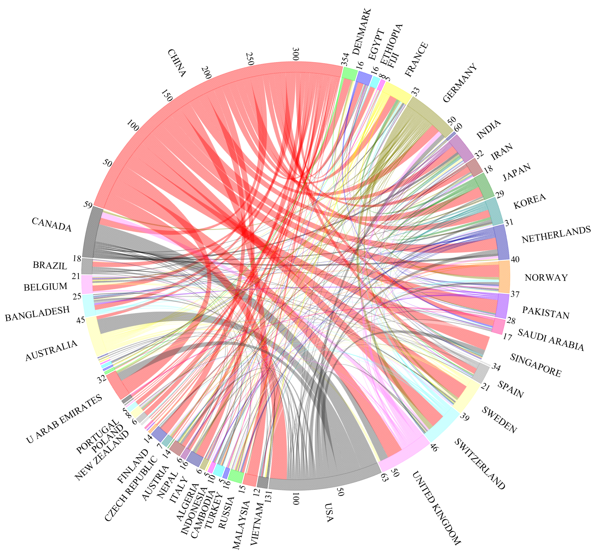
3.4. International Attention and Cooperation
4. Discussion
Author Contributions
Funding
Data Availability Statement
Conflicts of Interest
References
- Chen, C.M. CiteSpace II: Detecting and visualizing emerging trends and transient patterns in scientific literature. J. Am. Soc. Inf. Sci. Technol. 2006, 57, 359–377. [Google Scholar] [CrossRef]
- van Eck, N.J.; Waltman, L. Software survey: VOSviewer, a computer program for bibliometric mapping. Scientometrics 2010, 84, 523–538. [Google Scholar] [CrossRef] [PubMed]
- Qi, S.Z.; Liu, H.L. Natural and anthropogenic hazards in the Yellow River Delta, China. Nat. Hazards 2017, 85, 1907–1911. [Google Scholar] [CrossRef]
- Du, H.Q.; Xue, X.; Deng, X.H.; Zhang, X.H.; Wang, T. Wind erosion occurrence probabilities maps in the watershed of the Ningxia-Inner Mongolia reach of the Yellow River, China. Environ. Earth Sci. 2016, 75, 86. [Google Scholar] [CrossRef]
- Khan, S.U.; Cui, Y. Identifying the impact factors of sustainable development efficiency: Integrating environmental degradation, population density, industrial structure, GDP per capita, urbanization, and technology. Environ. Sci. Pollut. Res. 2022, 29, 56098–56113. [Google Scholar] [CrossRef]
- Jiang, L.; Zuo, Q.T.; Ma, J.X.; Zhang, Z.Z. Evaluation and prediction of the level of high-quality development: A case study of the Yellow River Basin, China. Ecol. Indic. 2021, 129, 107994. [Google Scholar] [CrossRef]
- Zhao, H.B.; Xu, X.M.; Tang, J.Q.; Wang, Z.Y.; Miao, C.H. Spatial pattern evolution and prediction scenario of habitat quality in typical fragile ecological region, China: A case study of the Yellow River floodplain area. Heliyon 2023, 9, e14430. [Google Scholar] [CrossRef]
- Dong, J.H.; Zhang, Z.B.; Liu, B.T.; Zhang, X.H.; Zhang, W.B.; Chen, L. Spatiotemporal variations and driving factors of habitat quality in the loess hilly area of the Yellow River Basin: A case study of Lanzhou City, China. J. Arid Land 2022, 14, 637–652. [Google Scholar] [CrossRef]
- Chen, Y.L.; He, Z.L.; Yue, T.M.; Mu, W.C.; Qin, F. Spatiotemporal evolution and multi-scenario prediction of habitat quality in the Yellow River Basin. Front. Ecol. Evol. 2023, 11, 1226676. [Google Scholar] [CrossRef]
- Yang, J.; Xie, B.P.; Zhang, D.G.; Mak-Mensah, E.; Pei, T.T. Habitat quality assessment and multi-scenario prediction of the Gansu-Qinghai section of the Yellow River Basin based on the FLUS-InVEST model. Front. Ecol. Evol. 2023, 11, 1228558. [Google Scholar] [CrossRef]
- Tang, J.J.; Zhou, L.; Dang, X.W.; Hu, F.N.; Yuan, B.; Yuan, Z.F.; Wei, L. Impacts and predictions of urban expansion on habitat quality in the densely populated areas: A case study of the Yellow River Basin, China. Ecol. Indic. 2023, 151, 110320. [Google Scholar] [CrossRef]
- Yang, J.; Xie, B.P.; Zhang, D.G. The Trade-Offs and Synergistic Relationships between Grassland Ecosystem Functions in the Yellow River Basin. Diversity 2021, 13, 505. [Google Scholar] [CrossRef]
- Wang, X.G.; Lian, Y.; Huang, C.; Wang, X.J.; Wang, R.L.; Shan, K.; Pedroli, B.; van Eupen, M.; ElMahdi, A.; Ali, M. Environmental flows and its evaluation of restoration effect based on LEDESS model in Yellow River Delta wetlands. Mitig. Adapt. Strateg. Glob. Chang. 2012, 17, 357–367. [Google Scholar] [CrossRef]
- Wang, X.Q.; Liu, F.G.; Zhang, X.B.; Tang, X.L.; Xu, J.W.; Huang, P.A.; Wang, Y.T.; Jin, Z.D. Asynchronized erosion effects due to climate and human activities on the central Chinese Loess Plateau during the Anthropocene and its implications for future soil and water management. Earth Surf. Process. Landf. 2022, 47, 1238–1251. [Google Scholar] [CrossRef]
- Zhang, Y.; Zhang, P.Y.; Liu, Z.Y.; Xing, G.R.; Chen, Z.; Chang, Y.H.; Wang, Q.X. Dynamic analysis of soil erosion in the affected area of the lower Yellow River based on RUSLE model. Heliyon 2024, 10, e23819. [Google Scholar] [CrossRef] [PubMed]
- Zhang, J.L.; Ge, Y.G.; Yuan, G.A.; Song, Z.Y. Consideration of high-quality development strategies for soil and water conservation on the loess plateau. Sci. Rep. 2022, 12, 8336. [Google Scholar] [CrossRef]
- Li, D.Z.; Li, T.N.; Wu, R.; Huang, Z.Y. Study on the impact of industrial structure upgrading on soil conservation in the Yellow River basin counties. Ecol. Indic. 2023, 154, 110683. [Google Scholar] [CrossRef]
- Wu, C.S.; Ma, G.X.; Yang, W.S.; Zhou, Y.; Peng, F.; Wang, J.N.; Yu, F. Assessment of Ecosystem Service Value and Its Differences in the Yellow River Basin and Yangtze River Basin. Sustainability 2021, 13, 3822. [Google Scholar] [CrossRef]
- Liu, Y.; Qu, B.; Jiang, E.H.; Hao, L.A.; Zhu, Y.W.; Jing, Y.C. Allocating payments for ecosystem services under future multiple scenarios in the Yellow River Basin, China. Ecol. Indic. 2023, 157, 111232. [Google Scholar] [CrossRef]
- Wang, P.; Xu, M.X. Dynamics and interactions of water-related ecosystem services in the Yellow River Basin, China. J. Geogr. Sci. 2023, 33, 1681–1701. [Google Scholar] [CrossRef]
- Zhang, Y.S.; Lu, X.; Liu, B.Y.; Wu, D.T.; Fu, G.; Zhao, Y.T.; Sun, P.L. Spatial relationships between ecosystem services and socioecological drivers across a large-scale region: A case study in the Yellow River Basin. Sci. Total Environ. 2021, 766, 142480. [Google Scholar] [CrossRef]
- Yang, J.; Xie, B.P.; Tao, W.Q.; Zhang, D.G. Ecosystem Services Assessment, Trade-Off, and Bundles in the Yellow River Basin, China. Diversity 2021, 13, 308. [Google Scholar] [CrossRef]
- Han, Z.Q.; Zuo, Q.T.; Wang, C.Q.; Gan, R. Impacts of Climate Change on Natural Runoff in the Yellow River Basin of China during 1961–2020. Water 2023, 15, 929. [Google Scholar] [CrossRef]
- Chen, L.; Yang, M.X.; Liu, X.; Lu, X. Attribution and Sensitivity Analysis of Runoff Variation in the Yellow River Basin under Climate Change. Sustainability 2022, 14, 14981. [Google Scholar] [CrossRef]
- Yu, X.; Xie, X.H.; Meng, S.S. Modeling the Responses of Water and Sediment Discharge to Climate Change in the Upper Yellow River Basin, China. J. Hydrol. Eng. 2017, 22, 05017026. [Google Scholar] [CrossRef]
- Ru, X.T.; Song, H.Q.; Xia, H.M.; Zhai, S.Y.; Wang, Y.B.; Min, R.Q.; Zhang, H.P.; Qiao, L.X. Effects of Land Use and Land Cover Change on Temperature in Summer over the Yellow River Basin, China. Remote Sens. 2022, 14, 4352. [Google Scholar] [CrossRef]
- Wang, X.J.; Zhang, J.Y.; Shamsuddin, S.; Oyang, R.; Guan, T.S.; Xue, J.G.; Zhang, X. Impacts of climate variability and changes on domestic water use in the Yellow River Basin of China. Mitig. Adapt. Strateg. Glob. Change 2017, 22, 595–608. [Google Scholar] [CrossRef]
- Zhang, Z.X.; Zou, X.; Zhang, C.; Sharifi, S. Has China’s River Chief System Improved the Quality of Water Environment? Take the Yellow River Basin as an Example. Pol. J. Environ. Stud. 2023, 32, 4403–4416. [Google Scholar] [CrossRef]
- Qu, S.; Zhao, Y.Z.; Li, M.H.; Zhang, K.Y.; Wang, J.L.; Duan, L.M.; Ma, H.L.; Miao, P.; Yu, R.H. Spatio-seasonal characteristics and controlling factors of surface water stable isotope values (δ18O and δD) across the Inner Mongolia Reaches of the Yellow River Basin, China: Implication for hydrological cycle. J. Hydrol.-Reg. Stud. 2024, 53, 101843. [Google Scholar] [CrossRef]
- Higgins, S.; Overeem, I.; Tanaka, A.; Syvitski, J.P.M. Land subsidence at aquaculture facilities in the Yellow River delta, China. Geophys. Res. Lett. 2013, 40, 3898–3902. [Google Scholar] [CrossRef]
- Zheng, S.; Wu, B.S.; Wang, K.R.; Tan, G.M.; Han, S.S.; Thorne, C.R. Evolution of the Yellow River delta, China: Impacts of channel avulsion and progradation. Int. J. Sediment Res. 2017, 32, 34–44. [Google Scholar] [CrossRef]
- Zhan, C.; Liang, C.; Zhao, L.; Jiang, S.Z.; Niu, K.J.; Zhang, Y.L. Drought-related cumulative and time-lag effects on vegetation dynamics across the Yellow River Basin, China. Ecol. Indic. 2022, 143, 109409. [Google Scholar] [CrossRef]
- Ji, Z.H.; Yu, W. Research on Spatial Difference, Distribution Dynamics and Influencing Factors of Urban Water-Use Efficiency in the Yellow River Basin. Sustainability 2023, 15, 405. [Google Scholar] [CrossRef]
- Liu, C.; Wang, Z.Y.; Walling, D. Establishment and development of the World Association for Sedimentation and Erosion Research. Int. J. Sediment Res. 2023, 38, 901–909. [Google Scholar] [CrossRef]
- Wohlfart, C.; Liu, G.H.; Huang, C.; Kuenzer, C. A River Basin over the Course of Time: Multi-Temporal Analyses of Land Surface Dynamics in the Yellow River Basin (China) Based on Medium Resolution Remote Sensing Data. Remote Sens. 2016, 8, 186. [Google Scholar] [CrossRef]
- Zhang, Z.W.; Zhang, J.Y.; Liu, L.P.; Gong, J.; Li, J.Q.; Kang, L. Spatial-Temporal Heterogeneity of Urbanization and Ecosystem Services in the Yellow River Basin. Sustainability 2023, 15, 3113. [Google Scholar] [CrossRef]
- Wang, Y.N.; Kong, X.B.; Guo, K.; Zhao, C.J.; Zhao, J.T. Spatiotemporal change in vegetation cover in the Yellow River Basin between 2000 and 2022 and driving forces analysis. Front. Ecol. Evol. 2023, 11, 1261210. [Google Scholar] [CrossRef]


| Representative Word | Specific Words |
|---|---|
| Yellow River basin environment | “Yellow-River basin environment”; “The Yellow River basin environment”; “The Yellow River catchment environment”; “The Yellow-River catchment environment”; “Yellow River catchment environment”; “Yellow-River catchment environment”; |
| Ecology of the Yellow River basin | “Ecology of the Yellow-River basin”; “Ecology of the Yellow River catchment”; “Ecology of the Yellow-River catchment”; |
| Ecology and environment of the Yellow River Basin | “Ecology and environment of the Yellow-River Basin”; “Ecology and environment of the Yellow-River catchment”; “Ecology and environment of the Yellow River catchment” |
| Cluster ID | Size | Silhouette | Label (LLR) |
|---|---|---|---|
| # 0 | 71 | 0.579 | the yellow river basin; habitat quality; invest model; influencing factors; ecosystem services |
| # 1 | 69 | 0.79 | climate change; runoff; sediment load; human activities; precipitation |
| # 2 | 63 | 0.689 | water quality; stable isotopes; source apportionment; risk assessment |
| # 3 | 37 | 0.617 | yellow river delta; sediment transport; normalized difference vegetation index; drought propagation |
| # 4 | 14 | 0.742 | cumulative effect; water use efficiency; |
Disclaimer/Publisher’s Note: The statements, opinions and data contained in all publications are solely those of the individual author(s) and contributor(s) and not of MDPI and/or the editor(s). MDPI and/or the editor(s) disclaim responsibility for any injury to people or property resulting from any ideas, methods, instructions or products referred to in the content. |
© 2024 by the authors. Licensee MDPI, Basel, Switzerland. This article is an open access article distributed under the terms and conditions of the Creative Commons Attribution (CC BY) license (https://creativecommons.org/licenses/by/4.0/).
Share and Cite
Gao, R.; Chen, H.; Wei, C.; Jiang, Y.; Zeng, S.; Zhang, C.; Jin, Y.; Zhang, W. Research Hotspots and Trends in the Environment Condition of the Yellow River Basin (2014–2024): A Bibliometric and Visualization. Water 2024, 16, 2359. https://doi.org/10.3390/w16172359
Gao R, Chen H, Wei C, Jiang Y, Zeng S, Zhang C, Jin Y, Zhang W. Research Hotspots and Trends in the Environment Condition of the Yellow River Basin (2014–2024): A Bibliometric and Visualization. Water. 2024; 16(17):2359. https://doi.org/10.3390/w16172359
Chicago/Turabian StyleGao, Ruoting, Hao Chen, Chunzhong Wei, Yanbo Jiang, Si Zeng, Chunfang Zhang, Yue Jin, and Wenjie Zhang. 2024. "Research Hotspots and Trends in the Environment Condition of the Yellow River Basin (2014–2024): A Bibliometric and Visualization" Water 16, no. 17: 2359. https://doi.org/10.3390/w16172359