Article

Comprehensive Study on Hydrogeological Conditions and Suitability Evaluation of In Situ Leaching for Sandstone-Hosted Uranium Deposit in Erlian Basin

1
Tianjin Center, China Geological Survey, Tianjin 300170, China
2
Tianjin Key Laboratory of Coast Geological Processes and Environmental Safety, Tianjin 300170, China
3
North China Center for Geoscience Innovation, China Geological Survey, Tianjin 300170, China
4
State Key Laboratory of Biogeology and Environmental Geology, China University of Geosciences, Beijing 100190, China
*
Author to whom correspondence should be addressed.
These authors contributed equally to this work.
Water 2024, 16(19), 2785; https://doi.org/10.3390/w16192785
Submission received: 28 August 2024 / Revised: 23 September 2024 / Accepted: 25 September 2024 / Published: 30 September 2024
(This article belongs to the Special Issue Soil and Groundwater Quality and Resources Assessment)

Abstract

:
As a strategic mineral and energy resource, the enrichment and metallogenic mechanism of sandstone-hosted uranium deposits are highly dependent on hydrogeological conditions. However, the relationship between sandstone uranium mineralization and hydrogeological conditions has not received sufficient attention yet. The pumping test, hydrogeological parameters and hydrochemical characteristics were employed to analyze the change characteristics of hydrogeological conditions and evaluate the suitability of in situ leaching (ISL). The results showed that the study area in the Inner Mongolia Autonomous Region could be divided into two groundwater subsystems, namely Quanzha-Engeriyin and Luhai-Zhendai. The latter with relatively high water richness is confined and a main ore-bearing aquifer, which consists of four orebodies. The well discharge (Q) and hydraulic conductivity (K) of Orebody II ranged from 98.40 to 867.36 m3/d and 0.25 to 5.64 m/d, respectively, indicating the aquifer is suitable for the migration, enrichment and mineralization of uranium due to relatively high permeability and fast flow rate. The water storage of Orebodies III-IV gradually deteriorated from east to west in a stepped pattern. And the highest values of Q and K in Orebodies III-IV decreased from 1200 m3/d to 120 m3/d and 1.75 m/d to 0.035 m/d, respectively, suggesting these were conducive to a reduction in and accumulation of uranium under poor hydrodynamic conditions. Additionally, the study area would be defined as three grades, including favorable, relatively favorable and unfavorable areas of ISL according to a comprehensive evaluation. This study provided a scientific basis for evaluating the possibility of in situ leaching for sandstone-hosted uranium deposit.

1. Introduction

As an important clean energy source with low carbon and high efficiency, nuclear energy has the potential to replace fossil fuels and meet the needs of large-scale industrial development [1,2,3,4]. Additionally, the development of nuclear energy can effectively mitigate the reliance on fossil fuels (such as petroleum, natural gas, and coal), thereby assuming an increasingly pivotal role in addressing environmental pollution issues [5,6,7]. Natural uranium (U), as a primary raw material for nuclear energy, is a crucial strategic mineral and energy resource globally. U holds significant importance for societal production and economic development [8,9,10]. The primary terrestrial uranium resources consist of sandstone-type, unconformity-type, and iron oxide-type deposits. Uranium ore deposits have been identified within sandstone, breccia, organic matter (OM)-rich sediments, unconformities, roll-front formations, and granitic plutons across all continents [9,11,12,13,14,15]. The sandstone-type uranium deposits are among the main types of uranium deposits in the United States, Australia, Niger, South Africa, and Central Asia [16,17]. Similarly, China primarily focuses on exploring and developing sandstone uranium deposits [10,17]. The sandstone-type uranium deposits make up 45.51% of the known resources and are widely recognized as the predominant forms of uranium deposits [18]. Therefore, sandstone uranium resources are an important material basis for the nation’s economic development. It is imperative to study sandstone uranium deposits’ enrichment laws and mineralization mechanisms to ensure their effective exploitation and sustainable utilization.
Numerous perspectives exist regarding the genetic classifications of sandstone-type uranium deposits. Nevertheless, the majority of investigations are grounded in mineralogy, geochemistry, and sedimentology [10,17,19,20,21]. In recent years, numerous studies have shown that the formation of sandstone-type uranium ore rolls is closely related to hydrogeological conditions. Uranium ore rolls, in particular, are prone to form in the front of the oxidation–reduction zone of the confined aquifer [9,16,19,22]. Typical sandstone-hosted U roll-front deposits are formed in confined aquifers at a redox front of oxidized groundwater reacting with unaltered reduced aquifer materials, often associated with organic detritus. During the migration process to the deep basin, groundwater undergoes hydrogeochemical processes primarily governed by redox reactions, resulting in the transformation of uranium into different valence states and its adsorption onto the surface of porous media solid particles, thereby facilitating mineral enrichment [15,22,23,24,25]. Consequently, the hydrogeological conditions are pivotal in elucidating the formation processes and mechanisms of sandstone-type uranium deposits, and in forecasting uranium mineralization targets [26,27,28,29,30]. However, the relationship between sandstone uranium mineralization and hydrogeological conditions (including hydrodynamics, hydrochemistry, and paleohydrogeology) has not yet received sufficient attention, necessitating further research.
In recent years, extensive coal and oil exploration efforts have confirmed the significance of uranium-bearing rocks in the sandstone strata of the late Cretaceous Saihan Formation in the Luhai area of the Erlian Basin, Inner Mongolia. The sandstone strata in this formation have the characteristics of shallow burial depth, good continuity, and high ratio of adsorbed uranium. However, the source and enrichment mechanisms of uranium deposits are not yet clear, and the key factors that influence the “hydrothermal uranium deposit genesis theory” are not yet understood. This paper systematically analyzes the geological characteristics of uranium deposits in the Luhai area, combining hydrogeological surveys and hydrogeological drilling, conducting field pumping tests, calculating hydrogeological parameters, and studying the hydrochemical characteristics. From the perspectives of groundwater flow field and hydrochemical characteristics, this study explores the hydrogeological and hydrodynamic conditions for uranium mineralization in sandstone. It reveals the differences and changes in features between uranium migration and the conditions. At the same time, this paper conducts a suitability evaluation of hydrogeological conditions for in situ leaching of uranium ore, providing a new perspective for studying uranium mineralization conditions. This study contributes to a deeper understanding of the relationship between basin sandstone uranium mineralization and hydrogeological conditions. It has significant scientific implications for the rational exploitation and utilization of sandstone uranium resources.

2. Study Area

2.1. Physical Geography

The Erlian Basin is located in the central–northern part of Inner Mongolia Autonomous Region, China, with a geographical range of 107°30′–119°10′ E and 40°40′–45°45′ N. It stretches from the east to the Greater Khingan Range, west to the Baoyintu Uplift, south to the northern foot of Yin Mountains, and north to the Sino-Mongolian border. The basin is oriented in a northeast direction and encompasses an area of approximately 110,000 km2. The Luhai mining area, located in the north–central Erlian Basin, falls under the jurisdiction of Sunite Left Banner in the Xilingol League of Inner Mongolia Autonomous Region. It is situated approximately 40 km away from Mandu Latuo Town, which serves as the administrative center for Sunite Left Banner (Figure 1). The study area is situated in the hinterland of Sunit Grassland, presenting a landform characterized by hills. The terrain exhibits a northeast high and southwest low trend, with an elevation ranging from 909 m to 945 m. Although the relative height difference is minimal, the surface water system is underdeveloped, resulting in only temporary gully floods during the rainy season. In other seasons, riverbeds and dish depressions remain dry without any water presence. The climatic conditions correspond to the typical temperate semi-arid continental monsoon climate type. The average annual precipitation is 300 mm, the evaporation is 2580.56 mm, and the precipitation is mostly concentrated in July and August, often appearing as showers and heavy rainstorms.

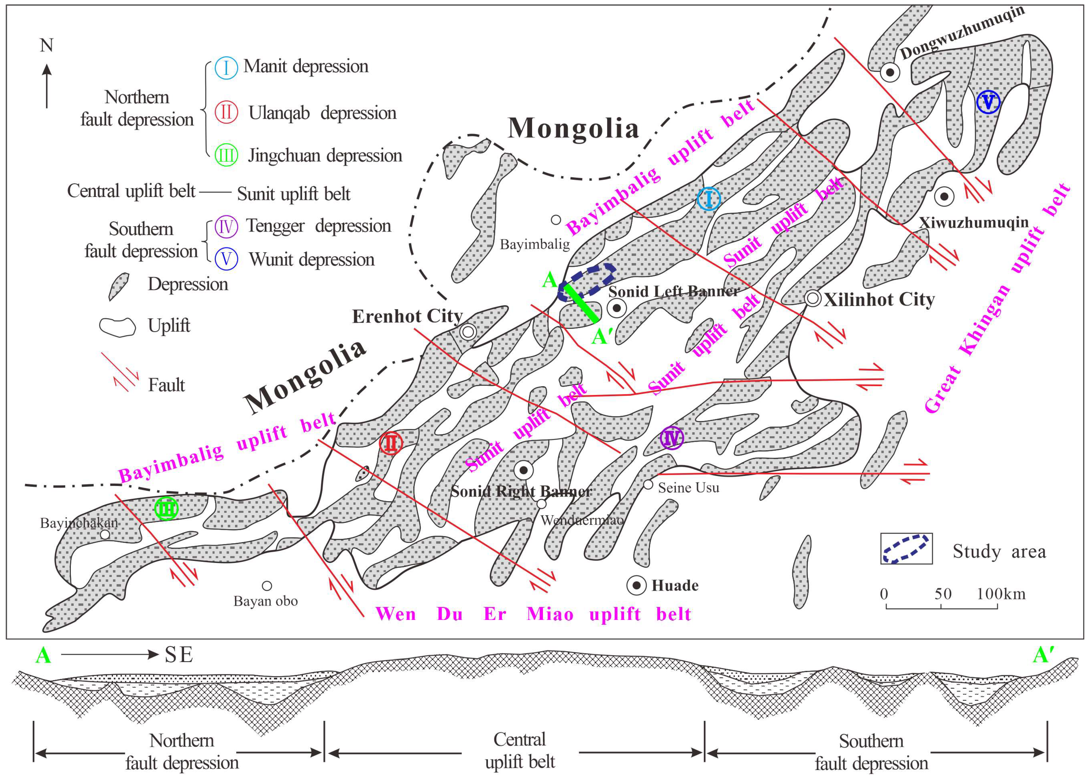
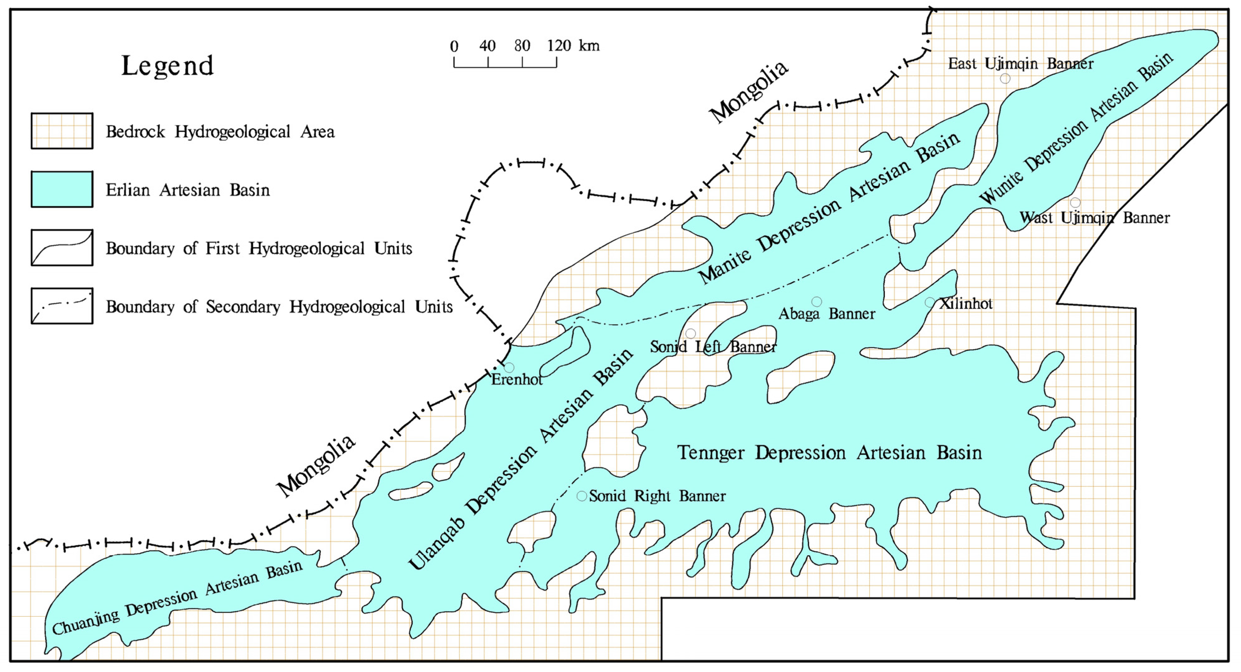
2.2. Regional Geological Structure

Erlian Basin is situated in the central and northern region of Inner Mongolia, occupying a tectonic position along the suture line between the Asian Plate and the Siberian Plate. This basin represents a vast Mesozoic and Cenozoic fault-depression sedimentary basin that developed on the folded basement of Inner Mongolia–Daxing’anling due to extensional–occlusive tectonic stress during the Yanshan period. The eastern boundary of the basin is situated in the northeastern region of the Great Xing’an Mountains, while its northern boundary extends towards Bayanbulak in a similar direction. The southern boundary runs from east to west and terminates at Wendul Temple, whereas the western boundary stretches northeastwards towards Solon Mountain (Figure 1). The basin is characterized by three levels of positive and negative tectonic units: the first level comprises faulted and uplifted zones, the second level consists of uplifted areas and depressions, and the third level exhibits both uplifts and depressions. Specifically, the first level tectonic unit has distinct divisions, including a northern fault zone, a central uplift zone, and a southern fault zone. Moreover, the second level tectonic unit can be further subdivided into six units comprising five depressions and one uplift. These structural units consist of multiple secondary depressions and uplifts, among which the Manit depression is most relevant to this study.
The Maniet depression is a significant secondary depression located in the northeastern region of the Erlian Basin. It exhibits a northeastward distribution, spanning approximately 300 km from east to west and measuring 20–80 km in width from north to south. The total area covered by this depression amounts to about 1.4 × 10⁴ km2. Its southeastern boundary lies adjacent to the Sunit uplift, while its northwestern boundary is in close proximity to the Bayanbulak uplift. The basement structure of this depression is highly complex, characterized by distinct convex and concave patterns. Generally, the depth of each depression’s basement ranges between 800 and 2800 m, with a maximum depth reaching up to 4500 m, whereas for the uplifted areas, basement depths range from 200 to 800 m. The study area is located within the sub-tectonic basin of Tabie Sag in Manite Sag, Erlian Basin. The Lower Cretaceous represents the primary sedimentary fill within this basin, while distinct basin types can be identified during different periods of the Early Cretaceous: fault depression type in the early Early Cretaceous, fault depression type in the late Early Cretaceous, and depression type following the Late Cretaceous.

2.3. Regional Stratigraphy

The Erlian Basin is a Mesozoic sedimentary basin developed on the Hercynian basement. The basement of the basin consists of Meso-Neoproterozoic and Paleozoic strata, which are extensively exposed in the bedrock mountains on both sides of the basin. The lithology primarily comprises granite, volcanic rock, and volcanic clastic rock. These rocks exhibit high uranium content that readily precipitates, thereby providing an abundant source for sandstone-type uranium deposit formation. The basin cover includes Mesozoic and Cenozoic continental clastic sedimentary strata such as Triassic, Jurassic, Cretaceous, Paleogene, Neogene, and Quaternary formations that can be categorized into three filling sequences (Figure 2).
The Luhai mining area is located in the southwestern margin of the Tabei Sag in the Manite Depression of the Ertan Basin (Figure 1). Most parts of the area are covered by Neogene Paleocene and Quaternary deposits, rich in coal, uranium, and other sedimentary minerals. Currently, a preliminary control has been established over a mineral belt with a length of 15 km. The extension of orebodies is controlled by ancient river valleys, which favor mineralization. The orebodies generally have a tabular shape and are buried at depths ranging from 70 to 150 m. Four main orebodies have been identified so far, occurring in sandstones above angular unconformities between the mudstones of the Upper Cretaceous Tenggeer Formation and sandstones of the Saihan Formation. The top part of these sandstone bodies consists of mudstones from the Saihan Formation, with an ore-body-thickness-to-sandstone-thickness ratio greater than 0.1. Furthermore, this mining area is adjacent to the already underground leached Bayanwula uranium deposit. It shares similar geological conditions for mineralization as well as similarities in terms of ore material composition and structural characteristics with that deposit. It possesses excellent resource endowment characterized by shallow burial depth, large-scale reserves with good continuity, high permeability, and adsorption capacity for hexavalent uranium ions, making it suitable for underground leaching development.

3. Materials and Methods

The in situ leaching uranium mining technique is an innovative and non-conventional method primarily utilized in sandstone uranium deposits [31,32]. In situ uranium mining technology utilizes the high water content of sandstone to introduce chemical reagents into the ore seam, facilitating a reaction between the reagent and uranium within the ore, resulting in the dissolution of uranium and the formation of leaching liquid. This liquid is subsequently extracted from the leaching hole and purified in a water refinery. Therefore, successful implementation of in situ uranium mining relies on both the distribution of ore deposits and hydrological conditions associated with the ore-bearing seam.
In the study area, a total of 20 geological drillings and 2 hydrogeological drillings datasets were collected, resulting in an overall penetration depth of 3457.89 m. Among them, the shallowest drilling depth was 85.11 m, while the deepest drilling depth reached 281.34 m. The depth of the hydrogeological drilling SZK01 was 160.86 m, and the depth of SZK02 was 253.62 m.
The pumping test method consists of stable flow pumping and unstable flow observation, which can be divided into two types. For machine-drilled wells, a simplified pumping test is employed, while hydrogeological exploration boreholes adopt stable flow pumping tests with no less than one set of pumping cycles [33]. The calculation of K, R, and T is carried out iteratively using the Dupuit Formula (1) and the Siechardt Formula (2) for confined aquifer single-well steady-state flow. The calculation formulas are as follows:
K = 0.366 Q M × s l g R r
R = 10 s K
T = K M
K represents the hydraulic conductivity (m/d), R represents the influence radius (m), T represents the coefficient of transmissivity (m/d), Q represents the well discharge (m3/d), r represents the well radius (m), s represents the drawdown value (m), and M represents the thickness of confined water aquifer (m).
The classification and evaluation indexes for in situ sandstone uranium deposits have been refined according to the nuclear industry standard of the People’s Republic of China, with a focus on assessing hydrogeological conditions in the Luhai area. The hydrogeological classification takes into account five key aspects: permeability, pressure-bearing capacity, unit water inflow, groundwater depth, and hydrogeological complexity (Table 1). Additionally, based on complexity levels, these deposits are categorized into three types.
(1) Type I: mineral deposits with simple hydrogeological conditions. The ore-bearing aquifer is buried at a depth of less than 350 m, exhibiting stable distribution and thickness of less than 30 m. It possesses stable rock strata acting as an impermeable roof and floor, lacking a hydraulic connection with other aquifers and surface water bodies. Additionally, it demonstrates strong confinement of water within the aquifer, while the burial depth of groundwater static water level remains below 50 m. The permeability of ore-bearing rocks in this aquifer surpasses that of non-ore-bearing rocks, displaying both high and moderate permeability levels.
(2) Type II: Mineral deposits under moderate hydrogeological conditions are characterized by an ore-bearing aquifer buried at depths of less than 350 m, showing a stable distribution with a thickness ranging from 30 to 50 m. The rock layers forming the impermeable roof and floor remain relatively stable and have limited hydraulic connections with other aquifers and surface water bodies. These deposits exhibit either strong confinement or weak confinement of water flow. The static groundwater level is typically found between depths of 50 and 150 m. Regarding permeability, the ore-bearing rocks within this aquifer demonstrate equal or higher permeability compared to non-ore-bearing rocks while also displaying more uniform patterns of permeability distribution. As such, these mineral deposits can be categorized as having strong or similar levels of permeability characteristics in accordance with scientific literature standards.
(3) Type III: mineral deposits characterized by intricate hydrogeological conditions. The underlying aquifer containing ores lies at depths shallower than 350 m but exhibits an unstable distribution pattern. It has an approximate thickness of around 50 m, with precarious rock formations serving as both impermeable roofs and floors. This type of deposit demonstrates a robust hydraulic connection with adjacent aquifers and surface waters; however, confined water may be scarce or absent altogether. Groundwater’s static level resides below depths exceeding 150 m in this context. The permeability of these ore-containing rocks within the aforementioned aquifer tends to be lower when compared to non-ore-bearing rocks, displaying irregular permeability traits that can generally be categorized as moderate or weak for mineral deposits.
Additionally, the TDS was measured by a gravimetric method. Major cations (K+, Na+, Ca2+, Mg2+) were measured with an Inductively Coupled Atomic Emission Spectrometer (ICP-AES, iCAP6300, Thermo, Waltham, MA, USA). SO42− and Cl were measured by ion chromatography (DX-120 IC, Dionex, Sunnyvale, CA, USA). HCO3 and CO32− were measured by the volumetric method.

4. Results

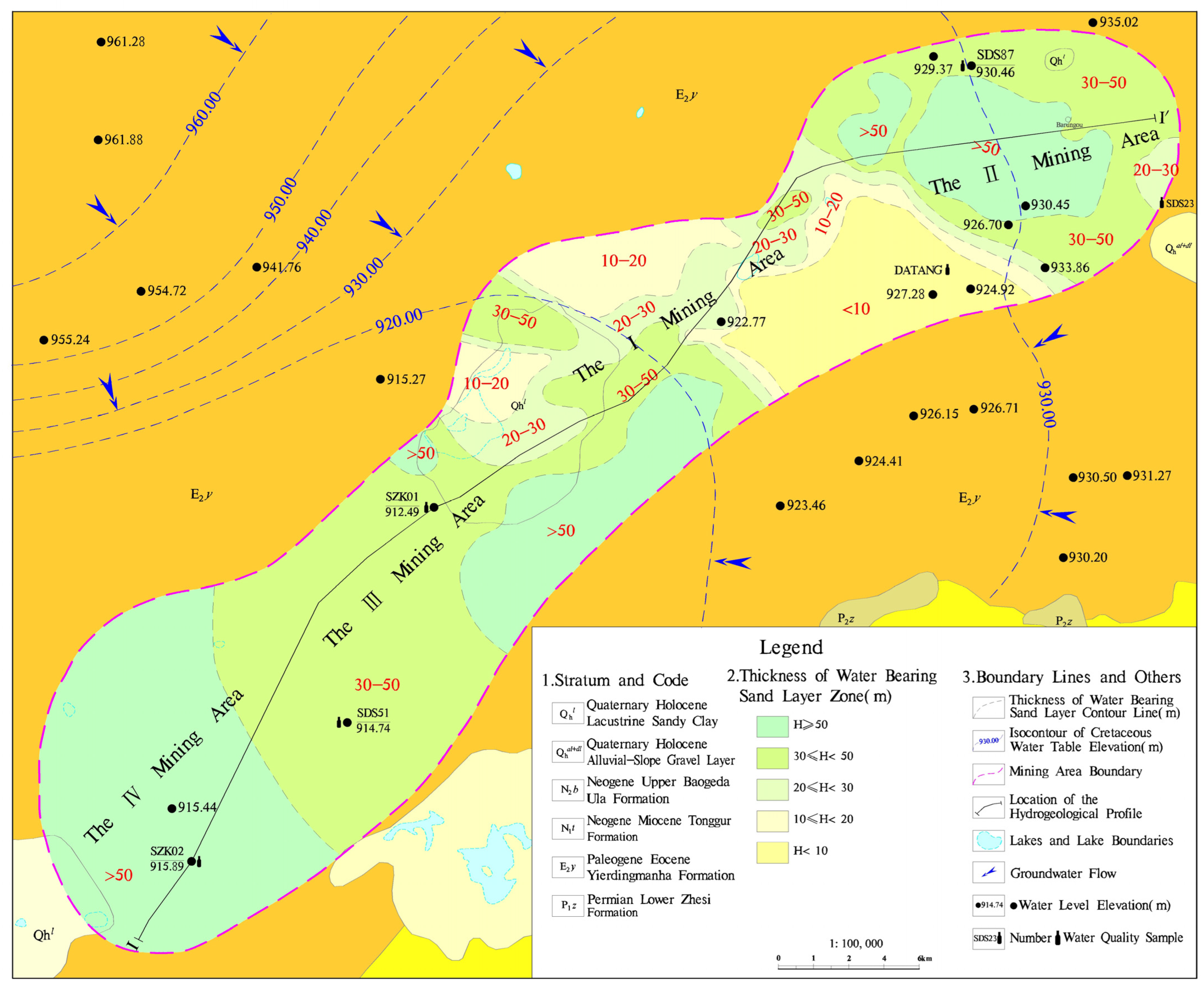
4.1. Hydrogeological Characteristics of Uranium Ore Beds in the Luhai Mining Area

4.1.1. Hydrodynamic Characteristics of Groundwater

The Erlian Basin belongs to a first-level hydrogeological unit. Based on the structural division of the basement and the modern characteristics of groundwater recharge, flow, and discharge, the Erlian Basin is further divided into five sub-level hydrogeological units: Chuanjing autochthonous basin, Wulanchabu autochthonous basin, Manit autochthonous basin, Uinit autochthonous basin, and Tengger autochthonous basin (Figure 3). The area under study is situated within the hydrogeological unit of Manit Depression, which serves as the runoff-discharge region for Manit Depression. The paleohydrogeological conditions in Manit Depression exhibit distinct segmentation and differential development, lacking a unified lake presence. Instead, it predominantly consists of various depressions that form an independent hydrogeological system.
According to variations in groundwater aquifer lithology, occurrence conditions, and hydraulic characteristics, the groundwater in the Luhai region can be classified into three primary types: bedrock fracture water, clastic rock fracture porosity water, and loose rock pore water. Bedrock fracture water is predominantly found in the erosion source areas of northwestern and southeastern regions where the aquifer lithology consists of Permian–Jurassic medium-acid intrusive rock, Permian clastic rock with limestone, and Carboniferous medium-acid volcanic rock with clastic rock that contains weathered fracture water. Groundwater distribution exhibits significant heterogeneity with low water content. However, well-developed structural fractures within fault zones contribute to a higher water content.
The clastic rock fissure porosity water is the predominant groundwater type in the region, widely distributed, and its water content is controlled by the sedimentary environment. Aquifers are poorly developed and have limited groundwater storage in areas such as alluvial fans, flood plains, and lacustrine sedimentary regions. Conversely, in river facies areas, the aquifer thickness increases, resulting in substantial subterranean groundwater storage. This groundwater type primarily occurs within the clastic rock pore-fissure water-bearing rock group of both Lower Cretaceous Saihan Formation and Paleogene formations. The Cretaceous aquifer is predominantly influenced by ancient riverbeds trending northeast and are extensively distributed across the central region of the terrace-like high plain. This aquifer demonstrates a stable and continuous belt-like distribution characteristic, oriented northeast, with a significant water-bearing capacity. The lithology of this aquifer consists predominantly of sandstone with occasional interlayers of mudstone and argillaceous siltstone in localized areas. On the other hand, the Paleogene aquifer occurs extensively across a vast area on a stepped-high plain but exhibits unstable distribution patterns with significant variations in thickness. The primary lithologies within this water-bearing rock group include coarse sandstone and gravel-bearing coarse sandstone, along with some occurrences of sandstone. Loose rock pore water mainly exists within intermountain alluvial plains (branched gullies), piedmont alluvial plains, and lake lowlands, where it forms quaternary sand gravel aquifers consisting of medium-coarse sands mixed with argillaceous silt layers ranging from 0.5 to 20 m thick; their average groundwater level remains below 3 m while inflow rates generally do not exceed 30 m3/d but can locally reach up to 100 m3/d mostly through diving flow mechanisms that exhibit pronounced seasonal dynamics.
The bedrock fractures in the Luhai region are predominantly recharged through vertical precipitation with pronounced seasonal variations in their dynamic behavior. They serve as crucial sources for replenishing both porous waters within loose rocks and fractured porous waters within clastic rocks. The peripheral and central uplift influences result in lateral recharge from bedrock fractures located in elevated regions, which contribute significantly to the recharge of porous waters within basins along with vertical infiltration from atmospheric sources. Moreover, runoff occurs at the edges of these basins, while discharge happens towards their interiors. Consequently, an autonomous yet comprehensive system encompassing replenishment–runoff–discharge is established within each depression’s self-flowing zone that exhibits distinctive hydrodynamic features.
The Luhai region is situated within the Manit depression, with the Bayanbaoligge uplift as the primary groundwater recharge zone and the Sunite uplift as a secondary recharge area. In terms of Mesoproterozoic pore fracture groundwater, it primarily undergoes vertical infiltration recharge from atmospheric precipitation and lateral recharge from upstream Cenozoic clastic rocks and bedrock characterized by hills on both sides. Under the control of bedrock and faults, groundwater flows southwestward, and it is mainly discharged through artificial extraction and lateral seepage. Mesoproterozoic pore fracture groundwater primarily undergoes vertical infiltration recharge from atmospheric precipitation and lateral recharge from upstream Cenozoic clastic rocks and bedrock characterized by hills on both sides. Due to geological formations and fault controls, the groundwater in this aquifer system flows from northeast to southwest within the basin, with artificial extraction and lateral flow being the main discharge modes.

4.1.2. Hydrogeological Study of Uranium Deposit

Uranium orebodies in the Luhai region are primarily distributed within the upper section of the Cretaceous Seihantala Formation (K1bs3) of the Bayanhua Group, with sporadic occurrences in the Paleogene Ildingmanha Formation (E2y). However, these orebodies are characterized by their thinness, small-scale nature, and lack of industrial value. Consequently, this study predominantly focuses on elucidating the hydrogeological characteristics specific to the upper section of the Cretaceous Seihantala Formation (K1bs3) within the Bayanhua Group. Based on existing exploration data, four main orebodies have been identified in this uranium mine: Orebody II, Orebody I, and Orebodies III-IV from northeast to southwest (Figure 4). Generally, there is an inherent instability observed in terms of roof distribution within the U-hosting aquifer, along with significant variations in thickness. However, its base corresponds to a relatively stable distribution consisting mainly of mudstone belonging to the middle section of the Cretaceous Seihantala Formation (K1bs2) within the Bayanhua Group.
(1)
Hydrogeological Characteristics of U-hosting Aquifer in Orebody II
The upper section of the Cretaceous Bayanhua Group Saihanbatala Formation (K1bs3) in the Orebody II area is thick, which is generally thick in the middle and thin around, and oval in shape. The middle part is the sedimentary center of the stratum, the thickness can reach 131.60 m, and the thickness in the northeast is of less than 40 m. From the southwest area to the boundary area of I and II orebodies there is an uplift area with a northwestern trend, and the upper section of the Saihanbatala Formation is missing in some drillings in the uplift area. In addition, the thickness change in the U-hosting aquifer in the Orebody II area is basically consistent with the upper section of the Saihanbatala Formation, which is thick in the middle, thin around, and oval in shape (Figure 4). The thickness of the central area can reach 108.00 m. The ore-bearing aquifer is mainly pebbly coarse sandstone, coarse sandstone, and conglomerate, and the thickness of the aquifer above the coarse sandstone accounts for more than 75% of the thickness of the whole orebody. For example, the thickness of the aquifer above the coarse sandstone is 89.10 m. The sorting and grinding of the ore-bearing aquifer are poor, which is angular–subangular, with different particle sizes and a high content of muddy material, about 5~10%. The cementation degree of the ore-bearing sand layer is relatively loose–dense.
The roof distribution of the Orebody II aquifer exhibits instability and significant thickness variations. Overall, the northern part is characterized by thinness, while the southern part displays greater thickness. Some areas are either absent or gradually transition into weak permeable layers with a high mud content, primarily composed of argillaceous siltstone and silty mudstone. The aquifer’s roof thickness in the northern section ranges from 0.85 to 4.54 m, and it gradually increases to 5–7 m in the central part, reaching a maximum thickness of 11.33–13.13 m. Generally, the thickness of aquifer roof exceeds 10 m in the southern portion, with a maximum thickness of 15.86 m. The bottom layer of this orebody’s aquifer corresponds to the middle section of the Cretaceous Bayanhua Group’s Seihantala Formation (K1bs2), mainly consisting of stable mudstone distribution. In this study, four mechanical wells surrounding the orebody were selected for simple pumping tests, yielding hydrogeological parameters as presented in Table 2. It can be observed that individual well water inflow within Orebody II’s vicinity ranges from 98.40 to 867.36 m3/d, and unit water inflow varies between 0.077 and 2.833 L/s·m, while hydraulic conductivity ranges from 0.25 to 5.64 m/d, indicating high permeability within the Orebody II area.
In addition, the TDS content of the groundwater in the ore-bearing aquifer of Orebody II ranges from 1143 to 1425 mg/L, with an average of 1262.3 mg/L. All samples exhibit brackish characteristics, which generally have lower TDS levels compared to the groundwater in the overlying aquifer and that of the surrounding area’s same layer and other orebodies (Figure 5). The hydrochemical composition of the water primarily consists of HCO3·Cl-Na or Cl·SO4-Na, indicating that the groundwater in this layer is deeply buried and lacks a direct connection with contemporary atmospheric precipitation or surface water sources. Consequently, the circulation and renewal rate of groundwater are slow. Notably, the main source of HCO3 in groundwater is the weathering hydrolysis of silicate minerals in sandstone, revealing the occurrence of water–rock interactions. Therefore, compared to other orebodies, Orebody II exhibits a relatively faster groundwater circulation and more substantial water–rock interaction. Considering the aquifer thickness and hydrogeological parameters obtained from pumping tests, the aquifer has relatively high permeability and a relatively fast flow rate, which is conducive to the migration, transformation, and enrichment of uranium ions in the groundwater within the aquifer.
(2)
Hydrogeological Characteristics of U-hosting Aquifer in Orebody I
The lithology of the ore-bearing strata primarily consists of coarse sandstone, with some occurrences of conglomerate. The water-bearing layer above the coarse sandstone makes up over 75% of the total thickness of the ore-bearing layer, while the clay content in the sand layer is relatively high, at approximately 10%. In the Orebody I area, within the upper section of the Seihantala Formation (K1bs3) in the Bayanhua Group Cretaceous, there are three sedimentary centers with varying thicknesses. Most areas have a thickness below 40 m, whereas the northeastern center ranges from 67.10 to 98.14 m, the western center from 56.17 to 69.96 m, and the southwestern center from 86.36 to 100.06 m (Figure 6). The variation in ore-bearing layer thickness corresponds closely to that of strata. It measures between 41.50 and 41.89 m in the northeast region, between 40.39 and 41.28 m in the west region, and between 59.74 and 62.76 m in the southwest region.
The roof distribution of the Orebody I aquifer exhibits instability, with significant variations in thickness. Specifically, the southeastern and western regions are characterized by thin layers, generally less than 5 m thick. In some areas, there are even missing sections or a gradual transition into weak permeable layers with a high mud content, primarily composed of argillaceous siltstone and silty mudstone. Conversely, the middle and southern areas gradually thicken, reaching their maximum thickness at approximately 23.72~26.74 m. The bottom of the Orebody I aquifer corresponds to the middle section of the Seihantala Formation (K1bs2) within the Cretaceous Bayanhua Group. This stratum predominantly consists of mudstone and displays relatively stable distribution patterns. Based on an analysis of aquifer distribution in this region, it is observed that single-well water inflow for uranium groundwater within this area does not exceed 120 m3/d, and in certain locations, it may be as low as 24 m3/d or below. To further investigate these characteristics, a simple pumping test was conducted on the SDS14 mechanical well located south of Orebody I. Table 3 presents the hydrogeological parameters obtained from this pumping test. Due to mixed mining activities involving both Paleogene and Cretaceous formations at this well site, both water inflow rates and hydraulic conductivity are substantial.
(3)
Hydrogeological Characteristics of U-hosting Aquifer in Orebodies III-IV
The upper section of the Cretaceous Bayanhua Group Seihantala Formation (K1bs3) in the Orebody III–IV area exhibits a gradual thickening trend from southeast to northwest and west, forming a stepped shape. In the southeastern part, the thickness of the Orebody II is only 49.09 m, while in the western region, which serves as the sedimentary center of this stratum, the Orebody IV reaches its maximum thickness with a sedimentary depth exceeding 100 m and reaching up to 124.15~136.19 m.
The thickness of the U-hosting aquifer in the Orebody III-IV area exhibits a consistent pattern with the stratigraphic variation in the upper section of the Saihanbatala Formation, gradually increasing from east to west in a stepped manner (Figure 6). The aquifer thickness ranges from 32.70 to 48.21 m in the Orebody II area, while exceeding 50 m in the Orebody IV area. The thickness of the aquifer containing water with a grain size greater than coarse sand makes up more than 75% of the total thickness of the aquifer in the deposit. However, this section displays poor sorting and grinding characteristics with angular–subangular particles of varying sizes, accompanied by approximately 10% muddy content which reaches up to around 10–15% in some parts of the Orebody IV area. Moreover, there is relatively loose–dense cementation within the sand layer hosting mineralization. The bottom of the Orebody III-IV aquifer is situated in the middle section of the Cretaceous Sayhantala Formation within the Bayanhua Group (K1bs2), primarily composed of mudstone and exhibiting a relatively consistent distribution.
The water yield property of the Orebody III-IV area is generally consistent with the trend of aquifer thickness, gradually deteriorating in a stepped manner from east to west. The eastern part of the Orebody II area exhibits the highest water inflow, ranging from 240 to 1200 m3/d per well, while the western part of the Orebody IV area experiences a lower water inflow, ranging from 24 to 120 m3/d per well. In this study, two hydrogeological exploration boreholes were drilled within the Orebody III-IV area and subjected to non-complete well stable flow pumping tests. The results of these tests are presented in Table 4.
The results of the pumping test indicate that the water inflow of a single well in the upper section of the Cretaceous Seihantala Formation, Bayanhua Group, located in the eastern area of Orebody II, is 1054.08 m3/d with a hydraulic conductivity of 1.75 m/d, demonstrating high-water-yield properties and permeability. Conversely, in the southern area of Orebody IV, the water inflow from a single well in the upper section of the Cretaceous Seihantala Formation is only 52.70 m3/d with a hydraulic conductivity as low as 0.035 m/d, indicating low-water-yield properties and permeability. The variation in groundwater richness within the Orebody III-IV area can be attributed to an uneven distribution of aquifers.
The TDS of the ore-bearing aquifer in Orebody III-IV, as depicted in Figure 5, ranges from 1243 to 11,757 mg/L, with an average value of 5064 mg/L. This value is generally higher compared to the aquifer groundwater found in the surrounding areas of the mine and other orebodies. The hydrochemical types primarily consist of HCO3·Cl-Na type and Cl-Na type. The presence of numerous chloride ions (Cl) as anions and predominantly sodium ions (Na+) as cations within the aquifer groundwater indicates a slow water circulation rate, long retention time, and weak regeneration capacity for this particular group. These conditions are conducive to uranium accumulation and mineralization within the aquifer.

4.1.3. Genetic Analysis of Sandstone-Type Uranium Deposits in the Luhai Area

As universally acknowledged, uranium primarily originates from the deep earth crust, with a relatively high concentration in bedrock during the orogenic period. Consequently, the mountainous region at the basin edge serves as an abundant source of uranium and sediment within the basin. Governed by sedimentation processes and influenced by groundwater in ore-bearing aquifers, uranium undergoes a continuous cycle of dissolution, filtration, migration, precipitation, and enrichment from its source area to form metallogenic belts. This complete oxidation–reduction evolution sequence ultimately leads to the enrichment of uranium into ore [20,26,27,34].
The groundwater in the bedrock fractures at the edge of the Erlian Basin is primarily vertically replenished by atmospheric precipitation, establishing a close hydraulic connection with both precipitation and surface water. This region exhibits a robust and cyclic groundwater circulation, characterized by abundant O2 and CO2 content, making it an important zone for the oxidation and dissolution of uranium elements. Subsequently, lateral runoff supplies the basin’s loose rock pore water as well as clastic rock fracture pore water. The migration of groundwater runoff leads to changes in the hydrogeological conditions of uranium-rich aquifers, increasing the lithologic detritus composition and enhanced cementation, gradually reducing permeability. Consequently, there is a decrease in groundwater flow rate with slow alternation. Continuous increases in TDS cause water chemical components to gradually reach saturation state. Groundwater transitions from an oxidation environment to a reduction environment as organic matter content increases, accompanied by high concentrations of H2S and CH4. This shift slows down the migration rate of uranium ions in groundwater, leading to continuous reduction and precipitation for mineralization formation [22,31,35,36,37,38].
From the regional hydrogeological perspective, Orebody I–IV are located in groundwater discharge areas (Figure 4). The migration rate of groundwater in the U-hosting aquifer is slow in the orebodies due to the poor permeability. The lack of hydraulic connection with external water bodies, such as meteoric water or surface water, is conducive to the reduction, enrichment and mineralization of uranium. Notably, according to the thickness of the U-hosting aquifer and the hydrogeological parameters (Figure 4, Table 1, Table 2, Table 3 and Table 4), the permeability and alternation of circulation of the aquifer in Orebody II are relatively best and fastest compared with other U-hosting aquifers. Furthermore, the content of uranium and radioactive element in the U-hosting aquifer is also an important indicator for evaluating the scale of uranium mineralization. The ranges of uranium and 238U concentration in groundwater samples in Orebody II (DATANG, SDS87, SDS23, Figure 4) are from 3.82 to 52.3 μg/L and from 48.1 to 659 mBq/L, respectively, higher than those in Orebody III-IV (SDS51, SZK01, SZK02, Figure 4), with uranium and 238U concentrations from 0.34 to 19.4 μg/L and from 4.28 to 244 mBq/L, respectively. This indicates that the U-hosting aquifer of Orebody II is able to receive more recharge of U-rich groundwater from upstream aquifers, resulting in a better metallogenic effect.

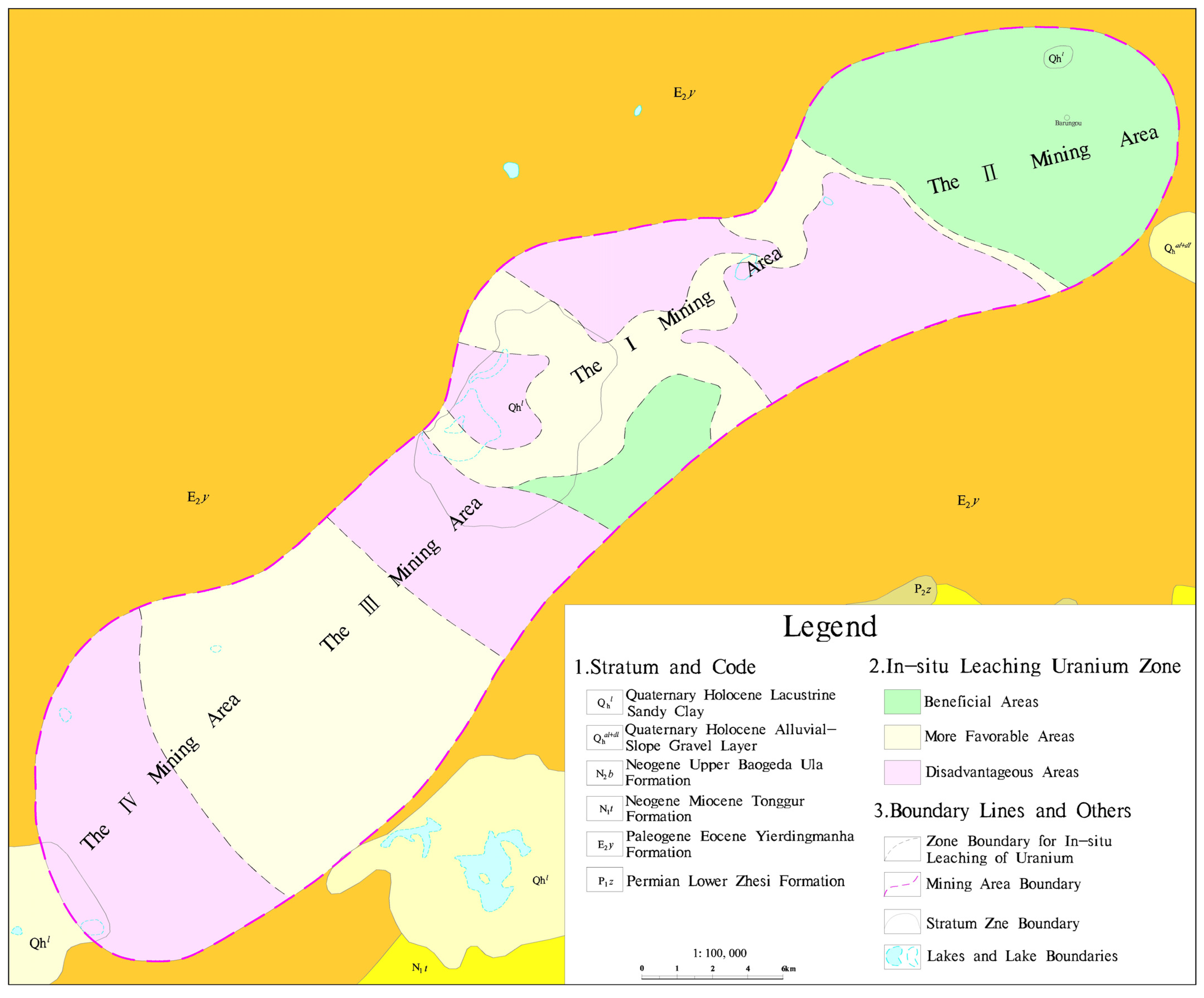
4.2. Evaluation of Suitability for Leaching and Mining of Sandstone-Type Uranium Ore

Based on the analysis of hydrogeological conditions for each orebody in both the onshore and offshore mining areas, and by referring to the hydrogeological classification method used for in situ sandstone-type uranium deposits, a hydrogeological classification was conducted for each orebody within these areas. The results of this classification are presented in Table 5.
The in situ hydrogeological conditions of sandstone-type uranium deposits are comprehensively evaluated based on a comprehensive reference to five major categories of indexes, including permeability, pressure-bearing capacity, unit water inflow, groundwater depth, and hydrogeological complexity. This evaluation encompasses 14 aspects: single-well water inflow, hydraulic conductivity, stability of the deposit’s roof and floor (hydrogeological structure), thickness of the ore-bearing aquifer, rock particle size, clay content, sorting characteristics, cementation degree, water depth and head height (water level), ratio of hydraulic conductivity between ore-bearing and non-ore-bearing layers, groundwater mineralization level and carbonate content. The evaluation parameters and grades can be found in Table 6.
According to the hydrogeological analysis of both onshore and offshore mining areas, significant changes in hydrogeological conditions can be observed. These changes primarily include water inflow, hydraulic conductivity, roof structure of the deposit, thickness of the ore-bearing aquifer, and salinity of groundwater. Evaluation indexes affecting in situ leaching of sandstone uranium deposits in these areas consist of water inflow from a single well, hydraulic conductivity, hydrogeological structure of the deposit, thickness ratio between the ore-bearing aquifer and uranium ore bed, and salinity of groundwater (Table 6). Comprehensive evaluation results indicate that most parts of the Orebody II area as well as the southwest region of the Orebody I are favorable for in situ leaching mining. Additionally, certain regions, including part of northwest area in Orebody II, central area in Orebody I, western area in Orebody II and eastern area in IV, are more suitable for this type of mining method, whereas other areas are deemed unfavorable for implementing an in situ leaching approach (Figure 6).
The presence of a continuous and stable impermeable roof and floor (such as mudstone, argillaceous siltstone, etc.) in the ore-bearing aquifer plays a crucial role in influencing in situ leaching mining operations. This factor significantly reduces the seepage range of the leaching solution within the aquifer, minimizes the dilution of the leaching solution, and decreases raw material consumption during production processes. Moreover, it effectively prevents contamination of adjacent upper and lower aquifers by preventing the flow of leaching solution into these areas. Additionally, considering gravity differentiation during the seepage process from injection to pumping holes is essential for successful in situ mining operations.
The main uranium ore layers with industrial value are predominantly located at the bottom of the aquifer in the Luhai area. The underlying water-proof roof, primarily composed of thick mudstone, exhibits a stable distribution pattern that effectively prevents pollution of the underlying aquifer caused by downward seepage of solution immersion liquid due to gravity differentiation. However, there is poor continuity in the water-proof roof within the land and sea area, particularly in the northern region of Orebody II and eastern/western regions of Orebody I, where the distribution becomes unstable. In these areas, the thickness gradually decreases or transitions into a weak permeable layer characterized by a high mud content mainly consisting of argillaceous siltstone and silty mudstone. Therefore, an important hydrological factor influencing in situ mining is the thickness of this water-proof roof. During in situ uranium mining operations within these two orebodies, it is crucial to properly control water pressure to prevent excessive passage over weak permeable layers and subsequent contamination of upper groundwater.

5. Conclusions

By conducting hydrogeological surveys, drilling, field pumping tests, and a comprehensive analysis of regional water chemical characteristics, we have obtained a thorough understanding of the current state and temporal variations in hydrogeological conditions within onshore–offshore sandstone-type uranium deposits. This has enabled us to assess the mining technical conditions of these deposits and evaluate the feasibility of in situ uranium mining in the study area.
(1) The distribution of Neogene clastic pore fracture water-bearing rocks exhibits instability, significant thickness variation, and poor continuity. Besides a small proportion of thick sandstone and conglomerate, the predominant lithology is muddy with limited water saturation. As one of the primary aquifers in the study area, the Paleogene clastic pore fracture water-bearing rocks demonstrate a gradual decline in water saturation from northeast to southwest. The upper section of the Cretaceous Bayanhua Group Saihanbatala Formation comprises the principal mineral aquifer layer characterized by coarse particles primarily composed of coarse sandstone and conglomerate. These layers exhibit a high mud content and varying degrees of cementation ranging from loose to dense, generally resulting in good-to-excellent water saturation levels with consistent layer thickness.
(2) From the regional hydrogeological perspective, the hydrodynamic conditions of groundwater in the study area are generally unfavorable, characterized by slow groundwater flow resulting from low permeability. These are conducive to the reduction, enrichment and mineralization of uranium. Nonetheless, distinct hydrogeological conditions, particularly variations in hydrodynamic changes in groundwater, ultimately determine the observed scale of mineralization across different orebodies. Therefore, compared to the other orebodies, the metallogenic effect of the U-hosting aquifer in II is better according to the hydrogeological conditions and the content of uranium and radioactive element.
(3) The comprehensive assessment of hydrogeological conditions for in situ mining indicates that the key evaluation factors influencing this method include single-well water inflow, hydraulic conductivity, hydrogeological structure of the deposit, thickness of the ore-bearing aquifer, ratio of ore-bearing aquifer to uranium ore bed thickness, and groundwater mineralization. Based on these factors, the onshore and offshore mining areas can be classified into three categories: favorable area, more favorable area, and unfavorable area for in situ mining. Specifically, most parts of Orebody II and the southwest region of Orebody I are considered favorable areas for in situ mining. The northwest section of Orebody II, middle part of Orebody I, west side of Orebody II and east side of Orebody IV are categorized as more favorable areas for in situ mining. Conversely, other regions are deemed unfavorable areas for in situ mining.

Author Contributions

Conceptualization, L.M. and W.J.; methodology, L.M.; software, H.N. and W.J.; validation, L.M., H.N. and Y.S.; formal analysis, Y.S.; investigation, L.M., W.W. and C.T.; resources, W.W. and C.T.; data curation, L.M. and H.N.; writing—original draft preparation, L.M. and H.N.; writing—review and editing, W.J. All authors have read and agreed to the published version of the manuscript.

Funding

This research was funded by the National Key Research and Development Program of China (2023YFC2906700); the National Natural Science Foundation of China (42302299); the program of China Geological Survey (DD20230426).

Data Availability Statement

Data available in a publicly accessible repository.

Conflicts of Interest

The authors declare no conflicts of interest.

References

  1. Cobb, J. World Nuclear Performance Report 2017. VGB PowerTech 2017, 12, 97. [Google Scholar]
  2. Tsouris, C. Uranium extraction: Fuel from seawater. Nat. Energy 2017, 4, 17022. [Google Scholar] [CrossRef]
  3. Wu, Y.; Cui, W.; Zhang, C.; Liang, R.; Qiu, J. Regenerable, anti-biofouling covalent organic frameworks for monitoring and extraction of uranium from seawater. Environ. Chem. Lett. 2021, 19, 1847–1856. [Google Scholar] [CrossRef]
  4. Ma, C.; Gao, J.; Wang, D.; Yuan, Y.; Wen, J.; Yan, B.; Zhao, S.; Zhao, X.; Sun, Y.; Wang, X. Sunlight Polymerization of Poly(amidoxime) Hydrogel Membrane for Enhanced Uranium Extraction from Seawater. Adv. Sci. 2019, 13, 1900085. [Google Scholar] [CrossRef]
  5. Yuan, Y.; Yu, Q.; Cao, M.; Feng, L.; Feng, S.; Liu, T.; Feng, T.; Yan, B.; Wang, Z.; Guo, N. Selective extraction of uranium from seawater with biofouling-resistant polymeric peptide. Nat. Sustain. 2021, 8, 708–714. [Google Scholar] [CrossRef]
  6. Wang, Y.; Lin, Z.; Liu, Q.; Zhu, J.; Liu, J.; Yu, J.; Chen, R.; Liu, P.; Wang, J. Simple one-step synthesis of woven amidoximated natural material bamboo strips for uranium extraction from seawater. Chem. Eng. J. 2021, 425, 131538. [Google Scholar] [CrossRef]
  7. Liu, Z.; Lan, Y.; Jia, J.; Geng, Y.; Dai, X.; Yan, L.; Hu, T.; Chen, J.; Matyjaszewski, K.; Ye, G. Multi-scale computer-aided design and photo-controlled macromolecular synthesis boosting uranium harvesting from seawater. Nat. Commun. 2022, 1, 3918. [Google Scholar] [CrossRef] [PubMed]
  8. Chen, J.; Zeng, W.; Wang, J.; Ma, L.; Yang, J. Analysis of supply and demand situation of uranium resourcesin the world and China. N. China Geol. 2021, 44, 25–34. (In Chinese) [Google Scholar]
  9. Cumberland, S.; Douglas, G.; Grice, K.; Moreau, J. Uranium mobility in organic matter-rich sediments: A review of geological and geochemical processes. Earth Sci. Rev. 2016, 1, 160–185. [Google Scholar] [CrossRef]
  10. Chen, L.; Chen, Y.; Feng, X.; Li, J.; Guo, H.; Miao, P.; Jin, R.; Tang, C.; Zhao, H.; Wang, G.; et al. Uranium occurrence state in the Tarangaole area of the Ordos Basin, China: Implications for enrichment and mineralization. Ore Geol. Rev. 2019, 115, 103034. [Google Scholar] [CrossRef]
  11. Bali, E. Economic geology: Uranium-ore giants. Nat. Geosci. 2012, 2, 96–97. [Google Scholar] [CrossRef]
  12. Cuney, M. The extreme diversity of uranium deposits. Miner. Deposita 2009, 1, 3–9. [Google Scholar] [CrossRef]
  13. Cuney, M. Evolution of Uranium Fractionation Processes through Time: Driving the Secular Variation of Uranium Deposit Types. Econ. Geol. 2010, 3, 553–569. [Google Scholar] [CrossRef]
  14. Mills, S.; Birch, W.; Maas, R.; Phillips, D.; Plimer, I. Lake Boga Granite, northwestern Victoria: Mineralogy, geochemistry and geochronology. J. Geol. Soc. Aust. 2008, 55, 281–299. [Google Scholar] [CrossRef]
  15. Bargar, J.; Williams, K.; Campbell, K.; Long, P.; Stubbs, J.; Suvorova, E.; Lezama-Pacheco, J.; Alessi, D.; Stylo, M.; Webb, S. Uranium redox transition pathways in acetate-amended sediments. Proc. Natl. Acad. Sci. USA 2013, 12, 4506–4511. [Google Scholar] [CrossRef]
  16. Yue, S.; Wang, G. Relationship between the hydrogeochemical environment and sandstone-type uranium mineralization in the Ili basin, China. Appl. Geochem. 2011, 26, 133–139. [Google Scholar] [CrossRef]
  17. Zhao, H.; Ao, C.; Li, J.; Chen, L.; Zhang, B.; Miao, P.; Si, Q.; Zhu, Q.; Yu, R.; Chen, Y. Occurrence and mechanism of uranium enrichment with a unique eolian sedimental environment in the Pengyang uranium deposit, Ordos Basin. Ore geol. Rev. 2022, 141, 104641. [Google Scholar] [CrossRef]
  18. Zhang, J.; Li, Z.; Su, X.; Tan, Y.; Li, S.; Su, Y.; Li, J.; Deng, P.; Xu, L.; Pan, Z. Development Strategy of Nuclear Energy Mineral Resources. Strateg. Study CAE 2019, 1, 113–118. (In Chinese) [Google Scholar] [CrossRef]
  19. Jin, R.; Yu, R.; Yang, J.; Zhou, X.; Teng, X.; Wang, S.; Si, Q.; Zhu, Q.; Zhang, T. Paleo-environmental constraints on uranium mineralization in the Ordos Basin: Evidence from the color zoning of U-bearing rock series. Ore Geol. Rev. J. Compr. Stud. Ore Genes. Ore Explor. 2019, 104, 175–189. [Google Scholar] [CrossRef]
  20. Chen, G.; Sun, Z.; Nie, F.; Li, C.; Zhen, Y.; Zhou, Z. Hydrogeochemical characteristics of the sandstone-hosted uranium mineralization in northern Ordos Basin, China. Ore Geol. Rev. 2020, 126, 103769. [Google Scholar] [CrossRef]
  21. Tao, Z.; Jiao, Y.; Wu, L.; Rong, H.; Zhang, F.; Yue, L. Architecture of a sandstone uranium reservoir and the spatial distribution of its internal carbonaceous debris: A case study of the Zhiluo Formation, eastern Ordos Basin, northern China. J. Asian Earth Sci. 2020, 191, 104219. [Google Scholar] [CrossRef]
  22. Bhattacharyya, A.; Campbell, K.; Kelly, S.; Roebbert, Y.; Weyer, S.; Bernier-Latmani, R.; Borch, T. Biogenic non-crystalline U(IV) revealed as major component in uranium ore deposits. Nat. Commun. 2017, 8, 15538. [Google Scholar] [CrossRef]
  23. Dai, S.; Yang, J.; Ward, C.; Hower, J.; Liu, H.; Garrison, T. Geochemical and mineralogical evidence for a coal-hosted uranium deposit in the Yili Basin, Xinjiang, northwestern China. Ore Geol. Rev. 2015, 70, 1–30. [Google Scholar] [CrossRef]
  24. Campbell, K.; Kukkadapu, R.; Qafoku, N.; Peacock, A.; Lesher, E.; Williams, K.; Bargar, J.; Wilkins, M.; Figueroa, L.; Ranville, J. Geochemical, mineralogical and microbiological characteristics of sediment from a naturally reduced zone in a uranium-contaminated aquifer. Appl. Geochem. 2012, 27, 8. [Google Scholar] [CrossRef]
  25. Miller, A.; Rodriguez, D.; Honeyman, B. Upscaling Sorption/Desorption Processes in Reactive Transport Models to Describe Metal/Radionuclide Transport: A Critical Review. Environ. Sci. Technol. 2010, 44, 7996–8007. [Google Scholar] [CrossRef]
  26. He, Y.; Rong, H.; Huang, K.; Peng, H.; Wan, J. Hydrogeochemistry Characteristics and Uranium Metallogenic Conditions of the Groundwater in Yili Basin. Saf. Environ. Eng. 2019, 1, 7–13. (In Chinese) [Google Scholar]
  27. He, Y.; Rong, H.; Huang, K.; Wang, Z.; Wan, J. Relationship between uranium mineralization and hydrologic condition in Yili Basin. Bullet Geol. Sci. Technol. 2020, 5, 139–147. (In Chinese) [Google Scholar]
  28. Yang, J.; Ao, C.; Meng, L.; Teng, X.; Wei, X.; Wang, D.; Feng, P.; Yu, H. Analysis of neogeneuranium reservoir development and uranium mineralization hydrogeological conditions in southwest Qaidam basin. Sci. Technol. Eng. 2022, 22, 931–938. (In Chinese) [Google Scholar]
  29. Hou, B.; Keeling, J.; Li, Z. Paleovalley-related uranium deposits in Australia and China: A review of geological and exploration models and methods. Ore Geol. Rev. 2017, 88, 201–234. [Google Scholar] [CrossRef]
  30. Liu, C.; Shi, Z.; Zachara, J. Kinetics of Uranium(VI) Desorption from Contaminated Sediments: Effect of Geochemical Conditions and Model Evaluation. Environ. Sci. Technol. 2009, 43, 6560–6566. [Google Scholar] [CrossRef]
  31. Lu, C.; Xiu, W.; Guo, H.; Lian, G.; Yang, B.; Zhang, T.; Bi, E.; Shi, Z. Multi-Isotope Based Identification and Quantification of Oxygen Consuming Processes in Uranium Hosting Aquifers with CO2 + O2 In Situ Leaching. Water Resour. Res. 2023, 3, e2022WR033980. [Google Scholar] [CrossRef]
  32. Su, X.; Liu, Z.; Yao, Y.; Du, Z. Petrology, mineralogy, and ore leaching of sandstone-hosted uranium deposits in the Ordos Basin, North China. Ore Geol. Rev. J. Compr. Stud. Ore Genes. Ore Explor. 2020, 127, 103768. [Google Scholar] [CrossRef]
  33. Liu, B.; Yan, G.; Ma, Y.; Scheuermann, A. Measurement of In-Situ Flow Rate in Borehole by Heat Pulse Flowmeter: Field-Case Study and Reflection. Geosciences 2023, 13, 146. [Google Scholar] [CrossRef]
  34. Zhang, Z.; Fan, H.; He, F.; Liu, H.; Jia, L.; Yi, L.; Yang, M. Features of hydrogeochemistry and uranium metallogenesis in Binxian County area on the southern margin of Ordos Basin. Geol. Bull. China 2017, 36, 503–510. (In Chinese) [Google Scholar]
  35. Chen, Z.; Man, A.; Chen, X.; Xiong, Y.; Shao, J.; Wang, L.; Sun, P. Relationship Between Hydrogeology and Sandstone Uranium Mineralization in Sedimentary Basin: A Case Study of Sandstone Uranium Survey in the Kailu Depression of the Songliao Basin. Geotecton. Et Metallog. 2021, 6, 1174–1184. [Google Scholar]
  36. Brown, S.; Basu, A.; Christensen, J.; Reimus, P.; Heikoop, J.; Simmons, A.; Woldegabriel, G.; Maher, K.; Weaver, K.; Clay, J. Isotopic Evidence for Reductive Immobilization of Uranium Across a Roll-Front Mineral Deposit. Environ. Sci. Technol. 2016, 50, 6189–6198. [Google Scholar] [CrossRef] [PubMed]
  37. Cheng, Y.; Jin, R.; Cuney, M.; Petrov, V.; Miao, P. The strata constraint on large scale sandstone-type uranium mineralization in Meso-Cenozoic basins, northern China. Acta Geol. Sin. 2024, 98, 1953–1976. (In Chinese) [Google Scholar]
  38. Sheng, Y.; Baars, O.; Guo, D.; Whitham, J.; Srivastava, S.; Dong, H. Mineral-bound trace metals as cofactors for anaerobic biological nitrogen fixation. Environ. Sci. Technol. 2023, 57, 7206–7216. [Google Scholar] [CrossRef]
Figure 1. Study area and structural division of Erlian Basin (the third-level tectonic units: 43 sags and 22 uplifts in the basin; 10 sags in the basin margin).
Water 16 02785 g001
Figure 2. Comprehensive columnar and tectonic evolution map of the middle Erlian Basin.
Water 16 02785 g002
Figure 3. Hydrogeological unit division map of Erlian Basin.
Water 16 02785 g003
Figure 4. Contour map illustrating the thickness of the aquifer sand layer in a uranium mine situated within the Luhai mining region.
Water 16 02785 g004aWater 16 02785 g004b
Figure 5. TDS contour map of groundwater of U-hosting aquifer in Luhai area.
Water 16 02785 g005
Figure 6. Comprehensive evaluation map of hydrogeological conditions for in situ leaching of sandstone type uranium ore in Luhai mining area.
Water 16 02785 g006
Table 1. Hydrogeological classification indexes of in situ leaching sandstone-type uranium deposits.
Permeability of Ore-Bearing AquiferBearing Capacity of Ore-Bearing Aquifer
Classification of depositK (m/d)Classification of depositGroundwater depth (m)
High permeabilityK ≥ 10High confined waterH ≥ 100
Relatively high permeability1 < K ≤ 10Relatively high confined water20 < H ≤ 100
General permeability0.1 < K ≤ 1Low confined waterH ≤ 20
Limited permeabilityK ≤ 0.1Non- confined waterMissing bulkhead
Inflow rate of water in the ore-bearing aquiferGroundwater table in the ore-bearing aquifer
Classification of depositInflow rate of water (L/s·m)Classification of depositGroundwater Table (m)
Huge water yieldQ ≥ 0.10Large depth of groundwater levelh ≥ 150
Large water yield0.05 < Q ≤ 0.10Medium depth of groundwater level50 < h ≤ 150
Small water yield0.01 < Q ≤ 0.05Little depth of groundwater levelh ≤ 50
Little water yieldQ ≤ 0.01
Table 2. Hydrogeological parameters for pumping test in the Luhai mining area II and surrounding area.
NumberDepth of Well (m)Well Discharge
(m3/d)
Specific Discharge
of a Well (L/S·m)
Drawdown
(m)
Hydraulic Conductivity (m/d)Transmissivity (m2/d)
SDS0576809.282.0194.644.15178.71
SDS21-112098.400.07714.70.257.50
SDS8790682.802.8332.795.64225.75
SDS90110867.361.2278.182.24108.17
Table 3. Hydrogeological parameters for pumping test in the Luhai mining area I and surrounding area.
NumberDepth of Well (m)Well Discharge
(m3/d)
Specific Discharge of a Well (L/S·m)Drawdown
(m)
Hydraulic Conductivity (m/d)Transmissivity (m2/d)
SDS1459443.285.7650.8911.01418.2
Table 4. Hydrogeological parameters of pumping test for Orebody III-IV and surrounding areas in the land–sea mining area.
NumberDepth of well (m)LocationAquifer Thickness (m)Well Discharge
(m3/d)
Specific Discharge of a Well (L/S·m)Drawdown
(m)
Hydraulic Conductivity
(m/d)
Transmissivity m2/d
SZK01126Orebody III 78.351054.081.3798.851.75137.06
780.241.5525.821.86146.01
485.522.0732.712.25176.01
SZK02158Orebody IV 27.4552.700.00967.540.0350.91
Table 5. Classification of hydrogeological conditions of each orebody in the Luhai area.
NumberOrebody IIOrebody IOrebody III Orebody IV
Classification Index
Permeability Relatively StrongMediumRelatively StrongMedium
Confined StrongStrongStrongStrong
Water yield LargeRelatively SmallLargeRelatively Small
Underground water level MediumMediumMediumMedium
Hydrogeological complexity MediumMediumMediumMedium
Table 6. Evaluation grade of hydrogeological conditions of ground immersion.
Evaluation ParameterEvaluation Grade of Hydrogeological Conditions of Ground Immersion
Most AdvantageousAdvantageousGenerally FavorableUnfavorable
Water yield (m3/d)1200–240240–120120–24≥1200 or <24
Hydraulic conductivity (m/d)10–11–0.50.5–0.1≥10 or <0.1
Hydrogeological structureStable watertight top and bottom anchorPoor stable watertight top and bottom anchorMissing watertight top and bottom anchor
Thickness of ore-bearing aquifer (m)20–3030–50, 10–2050–100<10 or ≥100
Rock granularityCoarse sandMedium sandFine sandSilty sand
Clay content (%)<1010–2020–30≥30
SortingGoodPreferablyMediumPoor
Cementation degreeLooseRelatively looseRelatively compactCompact
Underground water level (m)<5050–100100–150≥150
Head (m)≥100≥50≥20<20
Ratio of hydraulic conductivity between ore-bearing and non-ore-bearing layers≥11–0.750.75–0.5<0.5
Ratio of thickness of ore-bearing aquifer to ore layer1–55–10≥10
TDS (g/L)<11–33–5≥5
Carbonate content (%)<11–22–3≥3
Disclaimer/Publisher’s Note: The statements, opinions and data contained in all publications are solely those of the individual author(s) and contributor(s) and not of MDPI and/or the editor(s). MDPI and/or the editor(s) disclaim responsibility for any injury to people or property resulting from any ideas, methods, instructions or products referred to in the content.

