Article

One- and Three-Dimensional Hydrodynamic, Water Temperature, and Dissolved Oxygen Modeling Comparison

Department of Civil and Environmental Engineering, Auburn University, Auburn, AL 36849-5337, USA
*
Author to whom correspondence should be addressed.
Water 2024, 16(2), 317; https://doi.org/10.3390/w16020317
Submission received: 28 November 2023 / Revised: 12 January 2024 / Accepted: 12 January 2024 / Published: 17 January 2024
(This article belongs to the Special Issue Water-Quality Modeling, Volume II)

Abstract

:
Understanding and modeling water quality in a lake/reservoir is important to the effective management of aquatic ecosystems. The advantages and disadvantages of different water quality models make it challenging to choose the most suitable model; however, direct comparison of 1-D and 3-D models for lake water quality modeling can reveal their relative performance and enable modelers and lake managers to make informed decisions. In this study, we compared the 1-D model MINLAKE and the 3-D model EFDC+ for water temperature, ice cover, and dissolved oxygen (DO) simulation in three Minnesota lakes (50-m Carlos Lake, 23.5-m Trout Lake, and 5.6-m Pearl Lake). EFDC+ performed well for water temperature and DO simulation in the open water seasons with an average root mean square error (RMSE) of 1.32 °C and 1.48 mg/L, respectively. After analyzing the ice thickness with relevant data, it was found that EFDC+ calculates a shorter ice cover period and smaller ice thickness. EFDC+ does not consider snowfall for ice thickness simulation. The results also revealed that EFDC+ considers spatial variance and allows the user to select inflow/outflow locations precisely. This is important for large lakes with complex bathymetry or lakes having multiple inlets and outlets. MINLAKE is computationally less intensive than EFDC+, allowing rapid simulation of water quality parameters over many years under a variety of climate scenarios.

Graphical Abstract

1. Introduction

Eutrophication and anoxia are rising issues in many freshwater systems due to increased anthropogenic activity. High water temperature and low dissolved oxygen (DO) concentrations in freshwater are a global concern [1], and many aquatic ecosystems are suffering because of these conditions. Lack of oxygen can have negative effects on fish and other lake biota, including reduced respiration rates, diminished reproductive activity, forced changes in habitat location, and ultimately reduced fish populations [2,3]. As a result, water quality restoration is an important concern for many lake managers. Lake modeling is a useful tool to predict lake DO at a future time. Researchers are using lake models to simulate water temperature and DO in lakes to identify DO trends, leading to the development of numerous models. Over the past few decades, several 1-dimensional (1-D), 2-D, and 3-D lake models (Table S1 from Supplemental Information) have been developed and used to simulate hydrodynamics, temperature, and water quality parameters in lakes and reservoirs [4,5,6].
Some 1-D coupled hydrodynamic and water quality models (e.g., MINLAKE, DYRESM, and GLM) have been adopted to simulate thermal stratification dynamics and water-quality variables such as DO and nutrient concentrations with adequate accuracy in many water bodies [7,8,9,10]. 1-D models are widely used [4,11] due to their low number of required input parameters and reduced computation time. Models with higher dimensionality (2-D and 3-D models) provide increased detail regarding hydrodynamic effects and spatially varying inflow and transport mechanisms, such as density currents at river inflow locations. 3-D models provide the greatest hydrodynamic and water-quality resolution but require greater computational effort for simulation time and output storage. Some researchers have successfully coupled the 3-D model ELCOM with the 1-D model CAEDYM to simulate nutrient and phytoplankton dynamics in lakes [12,13]. ELCOM is a 3-D model that can simulate hydrodynamics, water temperature, and salinity, and CAEDYM is an aquatic ecological model designed to be readily linked to a hydrodynamic model. The 3-D model EFDC has been extensively used for hydrodynamics and water quality simulations because of its continuous development, computational accuracy, and flexibility [14,15]. Some of its uses include water quality simulation of Perdido Bay Wolf Bay estuary [15], modeling nitrogen and phosphorus contribution analysis in a lake basin [16], grading the eutrophic state of Tianjin reservoir in China [17], etc.
A primary difference between coupled hydrodynamic/water quality models is the spatial dimensions considered in the model. Model selection depends on modeling goals, desired accuracy, and the location and characteristics of the waterbody (e.g., maximum depth, trophic status, inflow condition, surface area, and mixing scenario). Sometimes, important information/processes accommodated in one model may not be in another. As a result, selecting the most appropriate model for a particular waterbody and modeling goals can be challenging. To aid in model selection, several studies have compared the performance of models with both similar and different spatial dimensions. For example, the Lake Model Intercomparison Project [18] compared the performance of various 1-D models for a number of reference lakes [18,19]. Mesman et al. [9] compared the performance of three 1-D hydrodynamic models (Simstrat, GOTM, GLM) during storms and heat waves. Yao et al. [20] compared four dynamic 1-D lake models for ice and temperature simulations in Harp Lake in Canada. Higher dimensionality does not always produce better simulation results [21]. DeGasperi [22] compared the performance of CE-QUAL-W2 (2-D) and CH3D-Z (3-D) in simulating the water temperature of Lake Sammamish in the USA. Both models produced similar results with slightly better performance statistics for the 2-D model. Al-Zubaidi and Wells [23] evaluated the capabilities of CE-QUAL-W2, and a three-dimensional adaptation of the same software known as (CE-QUAL-W3) in modeling temperature stratification in Laurence Lake, Oregon, USA. The predictions of both models were in agreement with the measurements; however, the 3-D model was 60 times more expensive in terms of computational time [23]. Ishikawa et al. [24] compared hydrodynamic simulations of 1-D (GLM), 2-D (CE-QUAL-W2), and 3-D (Delft3D) models, concluding that higher dimensionality produced better results. Man et al. [25] compared 1-D (GLM) and 3-D (Si3D) models for shallow reservoir water temperature and DO simulations. They recommended using the 1-D model for help with calibration but using the 3-D model for simulating thermal stratification and management interventions.
Choosing a model based on dimensionality usually depends on the objectives of the study, the water body characteristics, and computational cost and time. A direct comparison of modeling results using 1-D and 3-D models may be helpful in identifying the relative advantages and disadvantages of the two models in a quantitative manner. In numerical simulations, both temporal and spatial resolution are very important. Lower spatial resolution may fail to simulate hydrodynamic processes correctly or resolve bathymetry for waterbodies. The aim of this study is to quantify the relative advantages of 1-D and 3-D coupled hydrodynamic and water quality models and analyze ice cover and temperature dynamics simulated by the models. Ice cover, water temperature, and DO simulations are analyzed in three lakes in Minnesota: Pearl Lake (shallow), Trout Lake (medium depth), and Carlos Lake (deep) using the 1-D model MINLAKE and the 3-D model EFDC+.

2. Materials and Methods
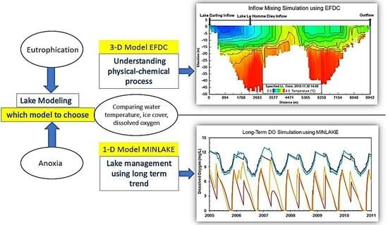
2.1. Models Used

For this study, the Minnesota Lake Water Quality Management Model (MINLAKE2020) was selected as the 1-D model because of its demonstrable efficiency and recent development. The latest version of MINLAKE, MINLAKE2020 [4], is used for this study since the model is capable of simulating water temperatures and other water quality parameters, as well as snow and ice cover during winter periods. The 3-D Environmental Fluid Dynamics Code (EFDC+) model was selected for its computational accuracy and ability to perform a variety of water quality computations.

2.1.1. 1-D Model

MINLAKE is a 1-D (along depth direction) deterministic water quality model with a time step of one day that was developed in the 1980s [26]. MINLAKE simulates a lake as a series of stacked horizontal layers of varying thickness. The MINLAKE model has been modified several times and has been successfully used for more than 30 years to simulate water quality parameters in different types of lakes. MINLAKE can reproduce selected constituent data with relatively high accuracy [27]. An important modification of MINLAKE was accomplished in 1994 when Fang and Stefan [28] developed the regional DO model and combined it with MINLAKE to study the impact of global climate warming on lake water quality and fish habitat in Minnesota lakes. The MINLAKE96 model, which simulates winter ice and snow cover, was further modified and refined and used in a 2010 study to simulate water quality conditions in The Cisco Lakes in Michigan and Wisconsin USA, which are typically deep mesotrophic or oligotrophic lakes [29]. This model and the next version of it, MINLAKE2012, did not simulate chlorophyll a (Chla), phosphorus, and nitrogen concentration on a daily basis but rather used estimated daily Chla based on the trend of observed Chla (during the simulation year) for DO simulation. MINLAKE2012 was further modified to include Chla, phosphorus, and DO subroutines, as well as inflow/outflow dynamics, and renamed MINLAKE2020. MINLAKE2020 was used to simulate water quality in six Minnesota lakes of different characteristics in 2021 [4].

2.1.2. 3-D Model

EFDC was initially developed at the Virginia Institute of Marine Science and has been refined extensively over the past three decades. The most recent version (EFDC+) is a state-of-the-art, versatile model used for simulating one-, two- or three-dimensional flow, transport, and biogeochemical processes in surface water systems such as rivers, lakes, estuaries, and reservoirs. It can be used to simulate the processes of hydrodynamics, sediment transport, water quality behavior, and eutrophication in one, two, and three dimensions. EFDC+ is a very flexible model which supports different options for representing the physical characteristics of the modeled domain, including sigma vertical coordinates and Cartesian or curvilinear orthogonal horizontal coordinates. EFDC+ can use fixed or dynamic time steps, depending on user preference and the safety factor provided by the user [30]. Although EFDC+ is very flexible and supports a wide variety of conditions, it is quite complex and difficult to apply if there is limited observational data for validation (calibration and verification).
In the past decade, EFDC has been extensively used to predict algal bloom in lakes, rivers, and reservoirs as well as in urban constructed ponds [31,32,33,34,35,36,37,38]. For example, the lower section of the Han River in South Korea experienced a severe algal bloom in 2015, and EFDC was used to understand algal dynamics in this system. Kim et al. [32] found that at least three algal groups need to be simulated to attain good Chla calibration accuracy for the study area. Zheng et al. [31] used EFDC combined with Long Short-Term Memory (LSTM) modeling (an artificial neural network modeling approach) to extend one-point data obtained by a single instrument to the entire 249 ha water area of their study domain on the BeiYun River in Beijing, China, to predict harmful algal blooms (HABs). 3-D EFDC models have also been used for assessing the risk of hazardous materials [35], the effects of submerged aquatic vegetation in internal loading [36], fishway planning and construction [34], eutrophication in urban ponds [37], and other predictive scenarios.

2.2. Ice Modeling Algorithms in Different Models

2.2.1. MINLAKE

The ice and snow algorithm in the Minnesota Lake model was originally developed by Gu and Stefan [39] and revised and improved by Fang et al. [40]. MINLAKE2020 uses a full heat budget equation to estimate surface cooling, quantifies the effect of forced convective (wind) mixing, and includes the latent heat removed by ice formation.
ρ i λ i d δ i d t = T m T a δ i k i + ( δ s k s + 1 h s a + k w d T d z z = 0
Here, ρi is the density of ice (kg/m3), λi is the latent heat of fusion of ice (kJ/kg), i is the change in ice thickness (m), hsa is the bulk heat-transfer coefficient (snow/air interface), δi and δs are ice thickness (m) and snow thickness (m), respectively. Thermal conductivity of ice and snow are represented by ki and ks, respectively (W/m/°C), Tm is the temperature at the bottom of the ice layer (0 °C), Ta is air temperature (°C), kw is the turbulent conductive heat transfer coefficient (kcal/day °C m), and dT/dz is the water temperature gradient near the ice-water interface (°C/m). Solar radiation penetrating the lake water below the ice is calculated by:
R i w = R s 1 β s 1 α s 1 β i 1 α i exp η s δ s exp η i δ i
Riw is the solar radiation penetrating the lake water below the ice (Langley/day), Rs is the total incoming solar radiation flux reaching the snow surface in winter or water surface in summer (Langley/day), βi and βs are surface reflectivity (albedo) for snow and ice, respectively, αi and αs are surface absorption coefficients for snow and ice, respectively, and ηi and ηs are attenuation coefficients (m−1) in ice and snow, respectively.
This algorithm has a fine (0.02 m) spatial resolution near the water surface where water temperature gradients before freeze-over are the greatest. Predicted freeze-over dates were compared with observations in nine Minnesota lakes for multiple (1 to 36) years [40]. The difference between the simulated and observed ice formation dates was less than 6 days for all lakes studied. Snow thickness is determined from snow accumulation (based on observations), followed by compaction and melting of snow by surface heat input (convection, rainfall, solar radiation) and melting within the snow layer due to internal absorption of shortwave radiation, and transformation of wetted snow to white ice when cracks in the ice cover allow water to spill onto the ice surface. In the model, ice growth occurs from the ice-water interface downward (black ice) and from the black ice surface upward (white ice). Ice decay occurs at the snow-ice interface, ice-water interface and within the ice layer. MINLAKE was used to predict snow- and ice-cover characteristics in small lakes (up to 10 km2) in the contiguous US under past and future climate scenarios [41].

2.2.2. EFDC+

EFDC+ has the same ice sub-model as CE-QUAL-W2 [42]. Ice formation and melt is simulated using a coupled heat approach. Ice forms when the surface water temperature lowers to the freezing point by normal heat exchange processes. With further heat removal, ice begins to form on the water surface, and negative water temperature is converted to equivalent ice thickness. The ice model includes an ice cover with ice-to-air heat exchange, conduction through the ice, conduction between underlying water, and a melt temperature layer on the ice bottom. The overall heat balance for the water-to-ice-to-air system is:
ρ i L f Δ h Δ t = h a i T i T e h w i T w T m
Here ρi is the density of ice (kg/m3), Lf is the latent heat of fusion of ice (J/kg), ∆h/∆t is the change in ice thickness (h) with time (t) (m/s), hai and hwi are the coefficients of ice-to-air heat exchange and water-to-ice heat exchange (through the melt layer), respectively (W/m2/°C). Ti is the ice temperature, Te is the equilibrium temperature of ice-to-air heat exchange, Tw is the water temperature below the ice, and Tm is the melt temperature. The solar radiation absorbed by water under the ice cover is calculated using the following equation:
R i w = R s 1 α i 1 β i exp η i δ i
Riw is the solar radiation absorbed by water under ice cover (W/m2), Rs is the incident solar radiation (W/m2). The freezing temperature is set at 0 °C for freshwater, but for saltwater, it is calculated as a function of total dissolved solids (TDS). Ice melting is calculated based on the net surface heat exchange. When net surface heat exchange is about to become positive, ice begins to melt, and the energy stored internally is used to melt the ice. The ice sub-model used by CE-QUAL-W2 and EFDC+ does not simulate snow thickness above the ice. Though these models simulate solar radiation extinction for the ice cover period, they do not simulate the attenuation of solar radiation by snow. It is worth mentioning that snow has a much higher attenuation coefficient (20–40 m−1) than ice, so a few centimeters of snow can completely attenuate all solar radiation.

2.3. DO Modeling Algorithm in Different Models

DO is an important parameter in lake water quality simulations. Equations (5) and (6) represent the governing equations for DO simulation by MINLAKE and EFDC+, respectively. Photosynthetic oxygen production and reaeration are source terms simulated in all models. EFDC+ allows the user to choose the reaeration equation from five available options and three different equations for DO saturation calculation. Moreover, EFDC+ can include external DO load in the simulation. MINLAKE can simulate a maximum of 3 algal classes, but EFDC+ can simulate several algal groups (>3) specified by users. Though the models simulate the same processes, the representation of these processes is different in their formulation; detailed descriptions can be found in the corresponding model documents.
MINLAKE:
N e t   c h a n g e   i n   D O                                                     = d i f f u s i o n + a l g a l   p h o t o s y n t h e s i s r e s p i r a t i o n B O D S O D n i t r i f i c a t i o n                                                     + r e a e r a t i o n z o o p l a n k t o n   r e s p i r a t i o n
EFDC+:
N e t   c h a n g e   i n   D O                                                     = a l g a l   p h o t o s y n t h e s i s a l g a l   r e s p i r a t i o n z o o p l a n k t o n   r e s p i r a t i o n n i t r i f i c a t i o n                                                     D O C   d e c o m p o s i t i o n C O D + R e a e r a t i o n S O D + e x t e r n a l   l o a d s

2.4. Modeling Process

Three lakes in Minnesota were simulated for this comparison study using 1-D MINLAKE and 3-D EFDC+ models. The nearest weather station to each lake provided meteorological data: St. Cloud Regional Airport for Carlos Lake and Pearl Lake; Grand Marais Cook County Airport for Trout Lake. Bathymetry data for the lakes were downloaded from the Minnesota Department of Natural Resources (MN DNR) LakeFinder website (https://www.dnr.state.mn.us/lakefind/index.html, accessed on 28 November 2023). EFDC+ uses atmospheric pressure, dry bulb temperature, relative humidity, rainfall, evaporation, solar radiation, cloud cover, wind speed, and wind direction as meteorological input. EFDC+ also has an algorithm to calculate solar radiation and evaporation. In this study, solar radiation data (from weather stations) and EFDC+-simulated evaporation were used. Simulation areas for each lake were constructed using a boundary polygon and dividing the surface area into uniform grids, incorporating bathymetry and boundary condition data. Lake inflow(s) and outflow(s) were added as flow boundaries, and time series of inflow/outflow and water temperature were provided by USGS [43]. Details of the observed data can be found in Table S2 in the Supplemental Information. EFDC+ simulates water temperature, organic carbon, organic phosphorus, organic nitrogen, ammonia nitrogen, nitrite nitrogen, silica, and three algal classes (diatom, green algae, blue-green algae), and chemical oxygen demand (COD) in order to simulate DO [44]. Setting up the 1-D MINLAKE model is much simpler than EFDC+. Bathymetry and inflow/outflow data with model parameters were fed into 1-D MINLAKE through an Excel spreadsheet user interface. Metrological data, including air and dew point temperature, solar radiation, cloud cover, wind speed, wind direction, precipitation, and snowfall were saved as text files for each simulated year. The same inflow and outflow data for EFDC+ were used for MINLAKE modeling to have the same boundary conditions. The model was calibrated for each lake using continuous 15-min water temperature measurements collected by the USGS for the open water seasons and DO profile data on monitoring days, downloaded from the MN DNR LakeFinder website.
The 3-D EFDC+ model gives users the opportunity to choose the coordinate system and the temperature model suitable for their particular waterbody from the available options. EFDC+ has three different water temperature models that are linked to meteorological data. Figure 1 shows example water temperature profiles for the stratification comparison in Trout Lake simulated using two coordinate systems against measured profiles. From Figure 1, it is evident that SGZ layering results match well with the observed data whereas the standard sigma layering results show discrepancy with the observed temperature.
Sigma coordinate models have issues handling sharp topographic changes from one grid to another. Because of its difficulty in handling horizontal density or pressure gradients [1], the standard sigma coordinate system cannot accurately represent stratified systems. The root mean square error (RMSE) for the sigma coordinate temperature is 2.6 °C, whereas it is 1.1 °C for the SGZ coordinate water temperature profiles from 25 May 2010 to 25 May 2011 in Trout Lake. Lake Carlos, being a deep and stratified lake, also had better stratification simulation using SGZ coordinates. However, for Pearl Lake, the simulated water temperature profiles showed no difference based on the layering option. The effect of the coordinate system on stratification simulation correlated with the lake’s mixing scenario. Since the SGZ layering system calculates stratification based on the minimum active cell approach, the deep and stratified lakes show better results with the SGZ system.
EFDC+ has the option to simulate water temperature using three different model options that couple with meteorological data. During 2010–2011, Lake Carlos had continuously measured 15-min water temperature data at 10 depths (1.65–37.5 m, 3–6 m intervals) collected by USGS Field [2], with a total of 331,910 measurement points. These valuable measurements were used to compare simulated water temperatures by three model options: (1) full heat balance, (2) equilibrium temperature, and (3) full heat balance with variable extinction coefficient (Table 1). In the full heat balance (legacy) option, the user needs to define the slow and fast attenuation coefficients. These coefficients do not depend on any other parameter and are constant throughout the simulation period. In the full heat balance (variable extinction coefficient) option, the extinction coefficient is calculated at each time step using the user-specified background (water) extinction coefficient and the simulated Chlorophyll-a (Chla), TDS, particulate organic carbon, dissolved organic carbon, and plant shoots. Table 1 lists RMSEs for water temperatures at all 10 depths. Water temperatures simulated by full heat balance with variable extinction coefficients approach has the minimum average RMSE among the three options, 1.16 °C. Based on the results, the SGZ coordinate system and ‘Full heat balance with variable extinction coefficient’ temperature model was used for this study.

3. Study Lakes

Three lakes with very different characteristics were selected for this study (Figure 2 and Table 2). The geometry ratio (GR = As0.25/Hmax, As in m2, and Hmax in m being the surface area and the maximum depth of the lake) is a characteristic parameter of a lake related to stratification [32]. The lower the geometry ratio, the stronger the lake stratification. Carlos and Trout Lakes are deep (Hmax > 20 m, [32]), strongly stratified (GR < 2, Table 1), oligotrophic (mean Chla < 4 µg/L, [45]) lakes, whereas Pearl Lake is a shallow eutrophic lake (mean Chla > 10 µg/L, [45]) polymictic lake (GR > 7).

3.1. Lake Carlos

Lake Carlos is the terminal lake in the Alexandria Chain of Lakes, located in the North Central Hardwood Forests ecoregion in Douglas County, Minnesota. Primary inflow to Lake Carlos occurs in the southern part of the lake through two distinct channels out of Lake Darling (USGS station number 05244780) and Lake Le Homme Dieu (USGS station number 05244810). The headwater of the Long Prairie River (USGS station number 05244820) is the principal outflow channel for the lake. The lake has two extensive deep areas (Figure 2a). The Minnesota Pollution Control Agency (MPCA) has six data collection stations on Lake Carlos. Station 101 (maximum depth Hmax = 49.12 m) and Station 102 (Hmax = 41.67 m) are placed in relatively deeper areas whereas Station 204 is located in a shallower area (Hmax = 23 m). 21-0057-00-101 (Station 101, Figure 2a) and 21-0057-00-102 (Station 102) have profile data for several days in the summer.

3.2. Trout Lake

Trout Lake is located within the Lake Superior Basin, approximately 16 km northeast of Grand Marais in Cook County, Minnesota. Trout Lake is part of the Northern Lakes and Forests ecoregion and is occasionally differentiated as a Canadian Shield Lake. Trout Lake is located in a bedrock basin and its geologic history is very different from Lake Carlos and Pearl Lake. Trout Lake is considered a dimictic lake, typically becoming stratified from May until October. Flow into Trout Lake is intermittent, making continuous discharge measurements difficult; therefore, periodic discharge measurements were completed at two small channels along the western margin of Trout Lake: (1) Trout Lake tributary, northwest side, near Covill, MN (USGS station number 04011140) and (2) Marsh Lake outlet (USGS station number 04011145). The Trout Lake outlet near Covill, MN, is the principal outflow channel for the lake. Trout Lake is vulnerable to substantial changes in the surrounding forest since the forest acts as a buffer on wind-driven mixing. MPCA has six monitoring stations on Trout Lake, but only one station was active from 2010 to 2011.

3.3. Pearl Lake

Pearl Lake is in the Sauk River Basin (part of the greater Mississippi River Basin) in Stearns County, MN. Pearl Lake is an intermittently stratified polymictic lake, having a slight decline in temperatures earlier in the year, but is generally well-mixed before early summer through late fall [46]. Pearl Lake has two inflow and one outflow locations: (a) inflow at the southwest corner, near Marty, MN (USGS station 0520447), (b) Mill Creek inlet (USGS station 05270448) inflow, and (c) Mill Creek outlet (USGS station 05270449). Though five monitoring stations were placed in Pearl Lake, during the study period (2014–2015), only one station had profile data.

4. Results and Discussion

4.1. Water Temperature

For both the MINLAKE (1-D) and EFDC+ (3-D) models, water temperature was calibrated first, followed by water quality parameters. Water temperature simulation is important since all other water quality parameters depend on this parameter. For EFDC+, a time step of 20 s was used for Lake Carlos, and a time step of 10 s was used for Trout and Pearl lakes. However, the simulated results were extracted at an interval of 1 h for EFDC+. Observed 15-min water temperature data for Carlos and Trout lakes were provided by USGS [43]. For Lake Carlos, the water temperature time series was measured at a location close to station 21-0057-00-102 (Figure 2a) and did not reach the maximum depth (49 m). Trout Lake has observed water temperature data at 8 depths (0, 2, 4, 6, 8, 12, 16, and 20 m) for the summer and early fall of 2010. Pearl Lake has a 30-min observed water temperature from the Sentinel Lake Program [47] at six depths (1.2, 1.7, 2.4, 3.4, 4.4, and 5 m). The details of observed water temperature data for all three lakes are provided in Tables S3–S5 in the Supplemental Information. Carlos Lake water temperature data from the USGS was collected in two segments: 15 depths in summer 2010 (with a maximum depth of 40.5 m) and 15 depths in fall 2010 and spring 2011 (with a maximum depth of 37.5). For time series continuity, only 10 depths were used in this study.
MINLAKE gives one simulated profile each day over the maximum depth, which can be assumed to occur at the deepest location, while EFDC+ outputs one simulated profile each hour at each grid (different maximum depths at different grids) for the three study lakes. Simulated and measured water temperature profiles over time at the deepest location are used to construct contour plots to understand and compare water temperature dynamics and stratification characteristics. Figure 3 shows these contour plots of water temperature simulated by EFDC+ (3-D) and MINLAKE (1-D) at Carlos, Trout, and Pearl Lake, including measured water temperature contours. EFDC+-simulated water temperature profiles were extracted at 21 depths, and MINLAKE-simulated water temperature profiles were extracted at 34 depths for Lake Carlos, which was compared with water temperature measured at 10 depths. Lake Carlos is considered a dimictic lake, generally starting off well-mixed before summer, with a distinctive thermocline (stratification) that develops in the summer months, as clearly shown in Figure 3a,b, mixing again in the late fall, with inverse temperature stratification in winter. In Figure 3a, MINLAKE2020 and EFDC+ simulated water temperatures have a root mean square error of 1.66 °C and 1.16 °C, respectively. At deeper depths (>30 m), MINLAKE simulated gradual temperature increases, while EFDC+ simulated temperatures and observed data have very small increases (more or less horizontal contour lines before the fall mixing). Overall, EFDC+ simulates more detailed water temperature profiles compared to MINLAKE.
In Trout Lake, MINLAKE and EFDC+-simulated water temperatures were extracted at 14 depths and were compared with observed water temperatures at 11 depths. Both EFDC+ and MINLAKE simulated water temperatures with RMSE of 1.5 °C. Both models slightly overestimate water temperature at the top layers during June–August. Compared with the observed water temperature, MINLAKE simulates lower water temperature in the bottom layers. Pearl Lake is a shallow lake having a maximum depth of only 5.5 m. MINLAKE and EFDC+-simulated water temperatures were extracted at 8 depths and were compared with observed water temperatures at 6 depths starting 1.2 m from the surface. In Figure 3c, MINLAKE2020 and EFDC+ simulated water temperatures have RMSE of 1.79 °C and 1.30 °C, respectively. Detailed statistical parameters for water temperature and DO simulation are provided in Table 3.

4.2. DO Simulation

Figure 4 shows the contour plots of simulated DO using EFDC+ (3-D) and MINLAKE (1-D) models at Carlos, Trout, and Pearl lakes, developed similarly to the temperature contours in Figure 3, except no observed DO contours are included, since continuous observed DO data were unavailable for any of the three lakes. In Figure 4, the right panel shows the comparison between observed and simulated DO near the surface and bottom of the lakes. MINLAKE simulated daily DO concentration, and hourly DO was extracted from EFDC+ results. In Figure 4a, at Lake Carlos, both MINLAKE and EFDC+ simulated anoxic conditions at the lake bottom in summer 2010 and winter 2011, with EFDC+ simulating a shorter anoxic period compared to MINLAKE, followed by a gradual mixing of DO starting in April 2011. The EFDC+-simulated DO concentration during late fall of 2010 and late winter of 2011 is higher than that simulated by MINLAKE. In Figure 4b, at Trout Lake, MINLAKE simulated an anoxic period starting in March, and ice melts in the beginning of May. EFDC+ simulated two periods of anoxia: one in February and another one in late April. For Pearl Lake, MINLAKE simulated lower DO concentration in Winter 2014.
The right panel shows the observed and simulated DO near the surface (1 m) and bottom (40 m, 20 m, and 5 m for Carlos, Trout, and Pearl lakes, respectively). The red box in the right panel shows the RMSE of simulated DO for all depths at all stations where observed data were available (28/29 depths at Lake Carlos 101 station, 27/28 depths at Lake Carlos 102 station, 16/17 depths at Lake Carlos 204 station, 17–29 depths at Trout Lake, and 5 depths at Pearl Lake). This RMSE also includes one DO profile measured in the summer of the following year (which is not graphed here).
Several DO profiles (8–10 profiles) were available for the summer and early fall on the LakeFinder website for each lake. The profiles were used to compare simulated results from EFDC+ and MINLAKE with observed data near the surface (1 m) and bottom of the lakes (Figure 4, right panel). Figure 4 (right panel) shows how the MINLAKE- and EFDC+-simulated DO time series at two depths compare with the observed data. Based on the availability of observed DO profiles, DO concentrations were plotted near the surface and the bottom of all three lakes from 25 May to 1 November of the simulation year. For Lake Carlos, the observed DO at the top and bottom layers match well with the simulated DO by EFDC+ (seven profiles on 5/25, 6/20, 6/24, 7/19, 8/24, 9/22, and 10/20). MINLAKE simulated anoxic conditions starting mid-September, whereas EFDC+ simulated anoxic conditions a month earlier, the same as the observed data. In Trout Lake, with 11 measured profiles, EFDC+ simulates longer bottom anoxic conditions in the summer due to stratification compared to MINLAKE. The EFDC+-simulated bottom DO concentrations match well with the observed bottom DO. Overall, EFDC+ simulated surface and bottom DO with good agreement, while MINLAKE simulated higher DO in bottom layers during summer. Pearl Lake had 9 measured profiles in 2014–2015. Pearl Lake is a weakly stratified lake; it remains more or less well-mixed throughout the year. However, two observed data points had very low DO at the bottom, which does not agree with seasonal lake characteristics and could not be simulated with either MINLAKE or EFDC+. This observed low bottom DO could be caused by short-term stratification, which can occur in shallow stormwater ponds, as noted in a recent study [48]. Altogether, the simulated DO is in good agreement with the observed DO. At the end of October, the observed data matched well with the MINLAKE-simulated DO, whereas EFDC+ overestimates the DO concentration.
Lake stratification is an important physical characteristic of a lake that influences mixing, aquatic habitat, etc. If temperature or DO differences between the surface and bottom layers are more than 1 °C or 1 mg/L, the condition is typically defined as stratified [49,50]. Figure 5 shows temperature and DO stratification simulated by EFDC+ and MINLAKE, along with the observed stratification in the three study lakes.
Temperature stratification captured by EFDC+ and MINLAKE at Lake Carlos is very similar to the observed data. For DO, EFDC-simulated DO difference matches well with the observed differences. EFDC+ simulates complete mixing in early November due to fall overturn. Suddenly the hourly DO differences become negative for a very short period; the oxygenated top layer DO go to the bottom due to overturn; the respiration and other biochemical processes might have consumed some additional DO from the top layer.
Figure 5b represents the simulated and observed stratification for Trout Lake. Both MINLAKE and EFDC+ models simulate slightly higher temperature stratification in the summer 2010 period where the observed data are available. EFDC-simulated DO stratification matches well with the observed stratification in summer, then EFDC+ simulates lower stratification in fall and a slightly later fall overturn. Though MINLAKE simulates slightly lower stratification in summer of 2010; in the fall, simulated stratification increases gradually and matches well with the observed stratification. EFDC+ simulates the overturn event later than that simulated by MINLAKE. The observed DO difference on 22 October 2010, being very close to the MINLAKE-simulated DO difference, confirms that MINLAKE simulates the overturn incident correctly. In Figure 5c, for Pearl Lake, both EFDC+ and MINLAKE simulated temperature differences match well with the observed data during the summer; during the winter MINLAKE simulated still matches reasonably well with the observed data; neither MINLAKE could reasonably mimic the observed inverse water temperature stratification during the ice cover period, but EFDC+ could not (with negligible temperature difference). MINLAKE simulates higher DO stratification than EFDC+ does during the ice cover period but there are no data for comparison.

4.3. Ice Cover Simulation

MINLAKE uses snowfall as a meteorological input and predicts/estimates snow thickness above the ice. Both MINLAKE and EFDC+ simulate the growth and decay of ice thickness during the winter, but only MINLAKE incorporates/considers the impact of snow thickness on ice cover simulations. Figure 6a compares ice thicknesses simulated by EFDC+ and MINLAKE. Both models predict the same ice formation date (2 January 2011) on Lake Carlos, but EFDC+ simulates less ice thickness and a shorter ice cover period. EFDC+ simulates 14 March 2011 as the ice melting day, whereas MINLAKE simulates 10 April 2011 as the ice melting day. Correct estimation of ice-in and ice-out day will affect the availability of nutrients and the biological processes in the lake [51]. Since ice thickness data are not available for our study period in Lake Carlos, observed snow depth (m) data from the Saint Cloud Regional Airport weather station (closest to Lake Carlos) were used as reference observations. However, there was a major snowfall event right after the ice melting simulated by EFDC+. The result is that EFDC+ underestimated ice thickness and the ice cover period, impacting DO simulations in the winter and spring periods. Similar results occurred for Trout Lake (Figure 6b) and Pearl Lake (Figure 6c). A significant disparity in ice thickness for Trout Lake was simulated by the two models. The maximum ice thickness simulated in 2010–2011 was 0.97 m by MINLAKE and 0.15 m by EFDC+. Trout Lake is a very small lake with an area of only 1 km2, situated in a colder (northern) region, where snow accumulated above the lake ice could be thick and persist over a longer period than predicted by MINLAKE. These factors could explain the difference between model results since EFDC+ does not simulate snow cover. Snow cover attenuation of solar radiation is much larger than the attenuation of ice and water [39]; a thin layer of snow can attenuate most of the incoming solar radiation and promote ice growth. For Pearl Lake, EFDC+ simulates three periods of ice cover in the winter from 2014–2015, while MINLAKE predicts a continuous ice cover from 13 November 2014 to 11 April 2015. In that winter, Saint Cloud Regional Airport had 67% less snowfall compared to that of 2010. The first few days after the snowfall were warmer, and EFDC+ predicted ice melting in some grids/areas which caused partial ice cover on the lakes. As a result, there were some gaps between ice cover periods, and solar radiation entered the lake through those openings and resulted in elevated phytoplankton abundance and well mixed conditions (Figure 4c). The results shown in Figure 4c were extracted from one simulation cell very close to the observation station. The different ice growth/decay rates in different cells were verified using the EFDC+ 2DV view. MINLAKE, being a 1-D model, predicts the growth/decay of ice cover over the entire lake surface and does not account for spatial variability of ice growth/decay in different grids as in EFDC+.
Table 4 lists the simulated ice-in and ice-out dates predicted by MINLAKE and EFDC+, and the simulated snow cover periods predicted by MINLAKE for the study lakes. Overall, EFDC+ simulates shorter ice cover periods and smaller ice thickness. Fang and Stefan [41] tested the lake ice formation and melting day using the MINLAKE ice sub-model for 9 lakes in Minnesota for 9–36 years. This study showed that the observed ice melting days for the lakes were not more than 6 days before or after the simulated ice melting day. MINLAKE was used in other comparison studies and was recommended for its robust ice model [18,20]. Yao et al. [20] compared four one-dimensional lake models: Hostetler, MINLAKE, SIM and General Lake Model for water temperature and winter ice cover simulation of Harp Lake (Ontario, Canada). MINLAKE generated the best agreement with observed ice-on and ice-off dates as well as ice thickness.
The effect of ice and snow thickness simulation can be explained using Figure 4. In Figure 4a, for the DO simulated by EFDC+, the DO concentration begins to increase near the surface (due to surface reaeration) after ice melting on 15 March 2010 and then the lake mixing (spring overturn) results in high DO for all layers. EFDC+ does not simulate snow thickness and solar radiation attenuation by snow (Equation (4)). For MINLAKE simulated DO profiles, the DO concentration does not increase after March because of ice and snow cover. The lake has snow thickness until 2 April 2010, solar radiation is attenuated by snow and ice to prevent any significant oxygen production by photosynthesis. Snow attenuates most of the solar radiation since MINLAKE uses 40 m−1 and 1.6 m−1 as extinction coefficients for snow and ice, respectively (Equation (2), [39]). Under snow cover, oxygen productivity becomes very low because of little or no solar radiation reaching the water. In Figure 4c, EFDC+ simulates high DO and well mixed conditions under ice cover since the lake had partial ice cover and the model assumed that phytoplankton growth and mixing both happened through the ice gaps. For lakes in cold regions, snow simulation holds considerable importance because of its influence on production and DO concentration.

4.4. Spatial Variance

The 1-D model MINLAKE cannot account for horizontal spatial variations of water quality constituents. Only 3-D models, such as EFDC+, can capture the spatial variability in all three dimensions. However, this difference is usually visible in large lakes [52]. Figure 7 shows water temperature (top panel) and DO (bottom panel) profile comparisons for two observation points, 101 and 102 (Figure 2), in Lake Carlos. The maximum difference in observed water temperatures between two locations at the same date and time is 2.3 °C, and the observed DO difference is 1.8 mg/L. It is evident that water temperatures at the surface layers were different on 25 May 2010 whereas water temperature varied in deeper layers from 22 June 2010 to 22 September 2010. The DO profiles also show some differences; surface DO is different in July and August. Overall, for June to August, water temperature and DO differ in deeper layers. Two EFDC+ profiles simulated at the two grids that enclose monitoring points 101 and 102 match better with the observed data compared to one MINLAKE simulated profile for these five observation dates.

4.5. Effect of Inflow

Water flowing into a lake/reservoir can take different flow paths after entering the lake, depending on density stratification in the lake and inflow conditions. Inflows are classified as underflows (spreading along the reservoir bottom), interflows (spreading or entraining at an intermediate water depth), or overflows (spreading at the reservoir surface). In 3-D models, inflow is discharged into a cell or several cells nearest the inflow location, whereas in 1-D models, the inflow eventually enters into the horizontal layer(s) where the inflow and ambient water have the same density. When several inflows enter into a large lake, spatial variance in temperature and other constituents may be observed.
Lake Carlos is a large, deep lake with inflow from two adjoining lakes, Lake Darling and Lake Le Homme Dieu (Figure 2). Observed inflow water temperatures from Lake Le Homme Dieu and Lake Darling are consistently slightly higher or very close to the surface water temperatures of Lake Carlos; therefore, the inflow regime for Lake Carlos is classified as overflow. When cooler water flows into the lake, the inflow water is entrained into the horizontal layers depending on inflow and lake water densities; this scenario is called interflow. To observe an interflow condition or entrainment of inflow water in Lake Carlos, the inflow temperatures were reduced by 4 °C. Using the observed inflow-outflow rates and the hypothetical (reduced) inflow temperatures, MINLAKE and EFDC+ models were simulated again, and the spatial variance was compared (Figure 8b).
The 1-D MINLAKE model simulated one vertical profile of temperature for the whole lake whereas the 3-D model simulated and calculated entrainment and vertical profiles for each grid. Based on proximity of the cell to the inflow location, mixing and entrainment vary location by location. Based on the MINLAKE-simulated water temperatures, the inflow was entrained more in the upper layers (0 m to 16 m) in the summer whereas it was entrained mostly in the deeper layer (16 m to 48 m) in the fall. Figure 8c shows the differences in EFDC-simulated water temperature at four depths in two cells of same depth (~40 m): Cell 1 and Cell 2. Cell 1 is downstream of Lake Darling inflow but upstream of Lake Le Homme Diu inflow; therefore, the temperature profile at Cell 1 is mainly affected by the inflow from Lake Darling. Since Cell 2 is downstream of both inflows, its temperature profile is affected by both inflows. The maximum difference in water temperature between Cell 1 and Cell 2 is 9 °C at 12 m depth from the surface and occurred in early July. At 14 m, 18 m and 22 m depths, the maximum water temperature difference was 6.98 °C, 4.35 °C and 3.35 °C, respectively.
Cell 1 is mostly impacted by Lake Darling inflow. At 12 m and 14 m, the peaks observed on 30 May 2010–1 June 2010, 19 June 2010, and 1 July 2010–8 July 2010 resulted from increased mixing of the lake water aided by higher wind speed; the water temperature at 12 m is close to the water temperature near the lake surface on these days. The water temperature increased on 24 August 2010–6 September 2010 due to the higher air temperature on those days. In Cell 2, a drop in water temperature occurred at 12 m on 5 July 2010, caused by the low inflow temperature from both inflows. At 18 m and 22 m, there are lower water temperatures at Cell 2 compared to Cell 1. Cell 2 is impacted by both inflows; this cell represents the full effect of Lake Le Homme Dieu which has lower inflow temperature compared to Lake Darling.
Figure 9 shows the spatial variations of simulated water temperature (EFDC+, the MINLAKE-simulated profile is shown in the box at the right-bottom of each panel) on three days through a cross-section cut through the center of the lake from Lake Darling inflow to Long Prairie River outflow (as shown in Figure 8a, black dashed path line). The cross-sectional view also shows two deep parts of the lake, the first near the Lake Darling inflow and the second near the Long Prairie River outflow.
Figure 9a shows spatial difference of water temperature during a summer day (6 January 2010). The inflow temperature was 16.03 °C at the Lake Darling inflow (2.42 m3/s) and 15.98 °C at the Lake Le Homme Dieu inflow (0.97 m3/s), with an outflow of 1.28 m3/s. The surface water temperature ranges from 17.41 °C to 14.83 °C and at 12 m, the water temperature ranges from 13.65 to 9.1 °C (near the second deep part). MINLAKE simulated water temperatures of 18.5 °C near the surface and it then gradually reduced to 4.8 °C near the lake bottom. Though Figure 9a shows similar temperature stratification throughout the lake, the second deep part has lower surface water temperature which could happen due to the mixing of cold water from Lake Le Homme Dieu.
Figure 9b shows the density current flowing towards the deep layers of the lake; a clear distinction of cooler inflow water is observed on the first deeper area. The inflow temperature was 3.14 °C at the Lake Darling inflow (2.75 m3/s) and 3.36 °C at the Lake Le Homme Dieu inflow (1.29 m3/s), with an outflow of 2 m3/s. The upper layers are well mixed and have a temperature close to 8 °C; the temperature drops to 7 °C at the lake bottom showing an example of underflow. MINLAKE simulated a well-mixed water temperature of 10.93 °C with a slightly lower temperature from 40 m below the surface.
Figure 9c shows the spatial difference of temperature during an ice cover period. Based on the ice thickness results from EFDC+, the ice starts melting on 12/4/2010 in areas close to Lake Darling. On 6 December 2010, the lake has ice cover only on the second deep part, limiting algae growth in that area. In response to Lake Darling inflow (0.3 m3/s) of 3 °C and Lake Le Homme Dieu inflow (0.5 m3/s) of 2.5 °C, the lighter inflow of water goes over the surface; this phenomenon is known as overflow. We can identify an increase in surface water temperature just upstream and downstream of Lake Le Homme Dieu inflow as a result of inflow from Lake Darling and Lake Le Homme Dieu. The water temperature shows stratification opposite to Figure 9a, cooler water on top and warmer water towards the bottom of the lake when temperatures are less than 4 °C. At the surface, the water temperature ranged from 0.029 °C to 0.85 °C. At 5 m depth, the temperature ranged from 0.13 °C to 1.5 °C. MINLAKE simulated near-zero water temperature at the top layer and ranged from 1.2 to 2.74 °C at the bottom layer. Since Lake Carlos is a large lake, the ice thickness varies over the longitudinal distance. Ice formation starts on 23 November 2010 near the outflow and gradually covers the whole lake by 8 December 2010. On 4 December 2010, the lake has ice cover on most of the cells along the centerline (Figure 8a) except some cells upstream and downstream of the Lake Le Homme Dieu inflow location.

4.6. Long-Term Simulation Using MINLAKE

For the three study lakes, the 3-D EFDC+ model requires more time to simulate water temperature and water quality constituents compared to the 1-D MINLAKE2020 model. Although this study focused primarily on water temperature and DO, the EFDC+ eutrophication model also simulates algae (green algae, blue-green algae, diatom), nitrogen, phosphorus, organic carbon, and silica for model accuracy before DO can be simulated. For EFDC+, the time required to simulate water temperature and selected water quality constituents for this study ranged from 2.0 h (for Pearl Lake) to 7.3 h (for Lake Carlos) for a 13-month simulation period (1 month warm-up period). Generally, simulation time depends on the number of computation grids and vertical layers. For Lake Carlos, 7.3 h were required for 1127 horizontal cells and a maximum of 35 vertical layers. MINLAKE simulation over the same time period was significantly faster than EFDC+, taking only a few seconds. However, as noted previously, the EFDC+ model provides much more detailed temporal and spatial simulation results.
Figure 10 shows MINLAKE 10-year simulation results for Lake Carlos near the surface (1 m) and bottom (48 m) for past (using historical weather data) and future (CCCma CGCM3.1 A1B Scenario) climate conditions. The CGCM3.1 [53] is the third generation coupled General Circulation Model from the Canadian Centre for Climate Modeling and Analysis (CCCma). The maximum water temperature stratification is observed in September and October of each year. The lake shows maximum stratification in 2001. MINLAKE has been used for long-term simulation in several studies [4,41]. Tasnim et al. [4] simulated Lake Elmo (a deep lake in Minnesota) for 20 years (1989–2009) with a regression coefficient (between simulated and observed) of 0.91 and 0.79 for water temperature and DO, respectively, using MINLAKE2020. This study also revealed that MINLAKE could mimic the increasing trend of phosphorus in 1997–2009. Moreover, MINLAKE can also simulate water quality using three future climate scenarios which are embedded in the model. Monthly air temperature increases projected by CGCM3.1 A1B scenario ranges from 2.91 to 4.84 °C near the St. Cloud weather station. As a deep oligotrophic lake, Lake Carlos had 24 days of anoxia for past climate conditions and is projected to have 78 days of anoxia for future climate conditions for the 10-year simulation period. Hypoxia (<1 mg/L DO) near lake bottom is simulated for 729 and 779 days for past and future climate conditions, respectively.
EFDC+ would take considerable computational time to simulate over multiple years. As a result, EFDC+ is not recommended for long-term simulation targeting lake management decision-making. 1-D MINLAKE can simulate water quality with sufficient accuracy while taking much less computational time, which is an advantage when conducting long-term and scenario studies for lake management practices. However, if a detailed understanding of lake processes is required over shorter time intervals, then the 3-D EFDC+ model is a more appropriate simulation tool. Man et al. [25] also performed a similar study for 1-D and 3-D models for hydrodynamic and water quality simulation of a shallow reservoir. A 1-D model was recommended when the stratification and mixing did not vary much, but a 3-D model was recommended to simulate stratification, mixing, and spatially variable water quality variables.

5. Conclusions

The 1-D model MINLAKE2020 and the 3-D model EFDC+ were compared based on the simulated water temperature and DO at Lake Carlos, Trout Lake, and Pearl Lake in Minnesota, USA. For Lake Carlos and Pearl Lake, the 3-D EFDC+ model performed better for temperature and DO simulations. EFDC+ DO simulation results for these lakes were much better than MINLAKE (Figure 4), though the statistical results only represent the summer period. The RMSE for DO simulation for Lake Carlos and Pearl Lake is 1.20 mg/L and 1.12 mg/L, respectively.
MINLAKE performed better than EFDC+ for Trout Lake as a consequence of better ice cover simulation. EFDC+ does not simulate snow thickness in cold region lakes. EFDC+ simulated shorter ice cover periods and smaller ice thicknesses in all three lakes. The early melting of ice predicted by EFDC+ can result in erroneous results for DO by simulating more mixing and overturns in the winter and spring. On the other hand, MINLAKE simulates both ice and snow thickness which makes it suitable for cold-region lakes.
EFDC+ considers spatial variance and performed well for both observation stations in Lake Carlos. This spatial variance is particularly important for very large lakes with complex bathymetry, or lakes having multiple inlets/outlets. EFDC+ can extract detailed hydrodynamics and water temperature/quality variables. Inflow locations can influence the spatial variance of different constituents (Figure 8). In the case of a large lake receiving a significant amount of inflow, ice thickness, water temperature, velocity magnitude, flow, etc., vary at different locations. The magnitude of differences depends on the distance of the comparing points and the difference between the inflow temperature and lake water temperature. Less computation time and effort are a great advantage of MINLAKE, which makes it a preferred option where applicable. MINLAKE can provide useful information for long-term lake management decision-making through long-term past and future scenario modeling.

Supplementary Materials

The following supporting information can be downloaded at https://www.mdpi.com/article/10.3390/w16020317/s1.

Author Contributions

B.T. conducted the simulations, analyzed the results, and prepared the manuscript draft and revisions. X.F. simulation runs, data analysis, and revised the manuscript. J.S.H. supervised the writing and revised the manuscript. All authors have read and agreed to the published version of the manuscript.

Funding

This research received no external funding.

Data Availability Statement

Some or all data, models, or code generated or used during the study are proprietary or confidential and may only be provided with restrictions. The model input and output data are specifically designed for a research numerical model. They are available upon request but are not useful for the general public.

Acknowledgments

The authors would like to express their gratitude towards Erik Smith (U.S Geological Survey) for providing the necessary data. He has provided us with 15-min flow and water temperature data for the inflow and outflow sources for all three study lakes, which were very important for model setup. He has also provided 15-min water temperature data at 15 depths (up to 40.5 m depth) for Lake Carlos for the Summer 20210, water temperature data at 15 depths (up to 37.5 m depth) for Fall 2010—Spring 2011, water temperature data at 11 depths for several months (9 June 2010—21 October 2010). The depth-wise water temperature data for Pearl Lake was collected from Sentinel lakes Long-Term Monitoring Program conducted by MN DNR. We would like to express our gratitude to MN DNR for providing us with the bathymetry data and DO profile data.

Conflicts of Interest

The authors declare no conflict of interest.

References

  1. Naderian, D.; Noori, R.; Heggy, E.; Bateni, S.M.; Bhattarai, R.; Nohegar, A.; Sharma, S. A water quality database for global lakes. Resour. Conserv. Recycl. 2024, 202, 107401. [Google Scholar] [CrossRef]
  2. Downing, J.A.; Polasky, S.; Olmstead, S.M. Protecting local water quality has global benefits. Nat. Commun. 2021, 12, 2709. [Google Scholar] [CrossRef] [PubMed]
  3. Sinclair, J.S.; Fraker, M.E.; Hood, J.M.; Reavie, E.D.; Ludsin, S.A. Eutrophication, water quality, and fisheries: A wicked management problem with insights from a century to change in Lake Erie. Ecol. Soc. 2023, 28, 10. [Google Scholar] [CrossRef]
  4. Tasnim, B.; Fang, X.; Hayworth, J.S.; Tian, D. Simulating Nutrients and Phytoplankton Dynamics in Lakes: Model Development and Applications. Water 2021, 13, 2088. [Google Scholar] [CrossRef]
  5. Cole, T.M.; Wells, S.A. CE-QUAL-W2: A Two-Dimensional, Laterally Averaged, Hydrodynamic and Water Quality Model, Version 3.2, User’s Manual; Environmental Laboratory, US Army Engineer Research and Development Center: Vicksburg, MS, USA, 2004; p. 39180. [Google Scholar]
  6. Hamrick, J. Calibration and Verification of the VIMS EFDC Model of the James River, Virginia; The College of William and Mary—Virginia Institute of Marine Science: Gloucester Point, VA, USA, 1995. [Google Scholar]
  7. Farrell, K.J.; Ward, N.K.; Krinos, A.I.; Hanson, P.C.; Daneshmand, V.; Figueiredo, R.J.; Carey, C.C. Ecosystem-scale nutrient cycling responses to increasing air temperatures vary with lake trophic status. Ecol. Model. 2020, 430, 109134. [Google Scholar] [CrossRef]
  8. Ward, N.K.; Steele, B.G.; Weathers, K.C.; Cottingham, K.I.; Ewing, H.A.; Hanson, P.C. Differential Response of maximum versus median Chlorophyll-a to Air Temperature and Nutrient Loads in an Oligotrophic Lake over 31 years. Water Resour. Res. 2020, 56, e2020WR027296. [Google Scholar] [CrossRef]
  9. Mesman, J.P.; Ayala, A.I.; Adrian, R.; Eyto, E.D.; Frassl, M.A.; Goyette, S.; Kasparian, J.; Perroud, M.; Stelzer, J.A.A.; Pierson, D.C.; et al. Performance of one-dimensional hydrodynamic lake models during short-term extreme weather events. Environ. Model. Softw. 2020, 133, 104852. [Google Scholar] [CrossRef]
  10. Andersen, T.K.; Nielsen, A.; Jeppesen, E.; Bolding, K.; Johansson, L.S.; Sondergaard, M.; Trolle, D. Simulating shifting ecological states in a restored, shallow lake with multiple single-model ensembles: Lake Arreskov, Denmark. Environ. Model. Softw. 2022, 156, 105501. [Google Scholar] [CrossRef]
  11. Patterson, J.C.; Imberger, J. Simulation of bubble plume destratification systems in reservoirs. Aquat. Sci. 1989, 51, 3–18. [Google Scholar] [CrossRef]
  12. Carraro, E.N.G.; Hamilton, D.; Valsecchi, L.; Manfredi, E.C.; Viviano, G.; Salerno, F.; Tratari, G.; Copetti, D. Coupling high-resolution measurements to a three dimensional lake model to assess the spatial and temporal dynamics of the cyanobacterium Planktothrix rubescens in a medium-sized lake. Hydrobiologia 2012, 698, 77–95. [Google Scholar] [CrossRef]
  13. Romero, J.R.; Antenucci, J.P.; Imberger, J. One- and three-dimensional biogeochemical simulations of two differing reservoirs. Ecol. Model. 2004, 174, 143–160. [Google Scholar] [CrossRef]
  14. Zou, R.; Bai, S.; Parker, A. Hydrodynamic and eutrophication modeling for a tidal marsh impacted estuarine system using EFDC. Estuar. Coast. Model. 2007, 561–589. [Google Scholar] [CrossRef]
  15. Li, X. Hydrodynamic and Water Quality Simulations in the Perdido and Wolf Bay System. (MS). Auburn University, Auburn, AL, USA. 2019. Available online: http://etd.auburn.edu/handle/10415/6726 (accessed on 10 March 2022).
  16. Bai, H.; Chen, Y.; Wang, D.; Zou, R.; Zhang, H.; Ye, R.; Ma, W.; Sun, Y. Developing an EFDC and numerical source-apportionment model for nitrogen and phosphorus contribution analysis in a lake basin. Water 2018, 10, 1315. [Google Scholar] [CrossRef]
  17. Zhang, C.; You, X. Application of EFDC model to grading the eutrophic state of reservoir: Case study in Tianjin Erwangzhuang reservoir, China. Eng. Appl. Comput. Fluid Mech. 2017, 11, 111–126. [Google Scholar] [CrossRef]
  18. Stepanenko, V.M.; Goyette, S.; Martynov, A.; Perroud, M.; Fang, X.; Mironov, D. First Steps of a Lake Model Intercomparison Project: LakeMIP. Boreal Environ. Res. 2010, 15, 191–202. [Google Scholar]
  19. Guseva, S.; Bleninger, T.; Johnk, K.; Polli, B.A.; Tan, Z.; Thiery, W.I.M.; Zhuang, Q.; Rusak, J.A.; Yao, H.; Lorke, A.; et al. Multimodel simulation of vertical gas transfer in a temperate lake. Hydrol. Earth Syst. Sci. 2020, 24, 697–715. [Google Scholar] [CrossRef]
  20. Yao, H.; Samal, N.R.; Joehnk, K.D.; Fang, X.; Bruce, L.C.; Pierson, D.C.; Rusak, J.A.; James, A. Comparing ice and temperature simulations by four dynamic lake models in Harp Lake: Past performance and future predictions. Hydrol. Process. 2014, 28, 4587–4601. [Google Scholar] [CrossRef]
  21. Wells, S.A. Thermal Stratification Effects in Lakes and Reservoirs. In Inland Waters; IntechOpen: London, UK, 2020. [Google Scholar]
  22. De Gasperi, C. Prediction Climate Change Effects on Kokanee Habitat Suitability in Lake Sammamish, Washington; King County: Seattle, WA, USA, 2013. [Google Scholar]
  23. Al-Zubaidi, H.A.; Wells, S. Comparison of a 2D and 3D Hydrodynamic and Water Quality Model for Lake Systems. In World Environmental and Water Resources Congress 2018; American Society of Civil Engineers: Reston, VA, USA, 2018. [Google Scholar]
  24. Ishikawa, M.; Gonzales, W.; Golyjeswski, O.; Sales, G.; Rigotti, A.; Bleninger, T.; Mannich, M.; Lorke, A. Effects of dimensionality on the performance of hydrodynamic models. Geosci. Model Dev. 2021, 20, 1–34. [Google Scholar]
  25. Man, X.; Lei, C.; Carey, C.C.; Little, J.C. Relative Performance of 1-D Versus 3-D Hydrodynamic, Water Quality Models for Predicting Water Temperature and Oxygen in a Shallow, Eutrophic, Managed Reservoir. Water 2021, 13, 88. [Google Scholar] [CrossRef]
  26. Riley, M.J.; Stefan, H.G. Minlake: A dynamic lake water quality simulation model. Ecol. Model. 1988, 43, 155–182. [Google Scholar] [CrossRef]
  27. Batick, B.M. Modeling Temperature and Dissolved Oxygen in the Cheatham Reservoir with CE-QUAL-W2; Vanderbilt University: Nashville, TN, USA, 2011. [Google Scholar]
  28. Fang, X.; Stefan, H.G. Modeling of Dissolved Oxygen Stratification Dynamics in Minnesota Lakes under Different Climate Scenarios; St Anthony Falls Hydraulic Laboratory—University of Minnesota: Minneapolis, MN, USA, 1994; 248p. [Google Scholar]
  29. Fang, X.; Alam, S.R.; Jacobson, P.; Pereira, D.; Stefan, H.G. Simulations of Water Quality in Cisco Lakes in Minnesota; St. Anthony Falls Laboratory—University of Minnesota: Minneapolis, MN, USA, 2010. [Google Scholar]
  30. Craig, P.M. User’s Manual for EFDC_Explorer 7: A Pre/Post Processor for the Environmental Fluid Dynamics Code; Dynamic Solutions-International, LLC: Washington, DC, USA, 2012. [Google Scholar]
  31. Zheng, L.; Wang, H.; Liu, C.; Zhang, S.; Ding, A.; Xie, E.; Li, J.; Wang, S. Prediction of harmful algal blooms in large water bodies using the combined EFDC and LSTM models. J. Environ. Manag. 2021, 295, 113060. [Google Scholar] [CrossRef] [PubMed]
  32. Kim, J.; Lee, T.; Seo, D. Algal bloom prediction of the lower Han River, Korea using the EFDC hydrodynamic and water quality model. Ecol. Model. 2017, 366, 27–36. [Google Scholar] [CrossRef]
  33. Wu, G.; Xu, Z. Prediction of algal blooming using EFDC model: Case study in the Daoxiang Lake. Ecol. Model. 2011, 222, 1245–1252. [Google Scholar] [CrossRef]
  34. Song, W.; Xu, Q.; Fu, X.; Wang, C.; Pang, Y.; Song, D. EFDC simulation of fishway in the Diversion Dahaerteng River to Danghe Reservoir, China. Ecol. Indic. 2019, 102, 704–715. [Google Scholar] [CrossRef]
  35. Huang, J.; Qi, L.; Gao, J.; Kim, D.-K. Risk assessment of hazardous materials loading into four large lakes in China: A new hydrodynamic indicator based on EFDC. Ecol. Indic. 2017, 80, 23–30. [Google Scholar] [CrossRef]
  36. Sun, B.; Chen, W.; Li, N.; Wang, W.; Fu, C.; Liu, Y.; Gao, X. Quantifying the effects of submerged aquatic vegetation on internal loading in lake: A modeling study of the largest shallow lake in North China. Sci. Total Environ. 2022, 853, 158593. [Google Scholar] [CrossRef] [PubMed]
  37. Luo, X.; Li, X. Using the EFDC model to evaluate the risks of eutrophication in an urban constructed pond from different water supply strategies. Ecol. Model. 2018, 372, 1–11. [Google Scholar] [CrossRef]
  38. Chen, L.; Yang, Z.; Liu, H. Assessing the eutrophication risk of the Danjiangkou Reservoir based on the EFDC model. Ecol. Eng. 2016, 96, 117–127. [Google Scholar] [CrossRef]
  39. Gu, R.; Stefan, H.G. Year-round temperature simulation of cold climate lakes. Cold Reg. Sci. Technol. 1990, 18, 147–160. [Google Scholar] [CrossRef]
  40. Fang, X.; Ellis, C.R.; Stefan, H.G. Simulation and observation of ice formation (freeze-over) in a lake. Cold Reg. Sci. Technol. 1996, 24, 129–145. [Google Scholar] [CrossRef]
  41. Fang, X.; Stefan, H.G. Simulations of climate effects on water temperature, dissolved oxygen, and ice and snow covers in lakes of the contiguous United States under past and future climate scenarios. Limnol. Oceanogr. 2009, 54, 2359–2370. [Google Scholar] [CrossRef]
  42. Cole, T.M.; Wells, S.A. CE-QUAL-W2: A Two-Dimensional, Laterally Averaged, Hydrodynamic and Water Quality Model, Version 3.6 User Manual; US Army Engineering and Research Development Center: Vicksburg, MS, USA, 2010. [Google Scholar]
  43. Smith, E.A.; Kiesling, R.L.; Galloway, J.M.; Ziegeweid, J.R. Water Quality and Algal Community Dynamics of Three Sentinel Deepwater Lakes in Minnesota Utilizing CE-QUAL-W2 Models; US Department of the Interior, US Geological Survey: Virginia, VA, USA, 2014. [Google Scholar]
  44. DSI. EFDC+ Theory Version 10.2; DSI, LLC: Edmonds, WA, USA, 2020. [Google Scholar]
  45. NAS; NAE. Water Quality Criteria 1972—A Report of The Committee on Water Quality Criteria; Environmental Protection Agency: Washington, DC, USA, 1973. [Google Scholar]
  46. Anderson, D.M.; Cembella, A.D.; Hallegraeff, G.M. Progress in understanding Harmful Algal Blooms: Paradigm shifts and new technologies for research, monitoring, and management. Annu. Rev. Mar. Sci. 2012, 4, 143–176. [Google Scholar] [CrossRef]
  47. MNDNR. Minnesota Department of Natural Resources-Sentinel Lake Monitoring. Available online: https://www.dnr.state.mn.us/fisheries/slice/sentinel-lakes-monitoring.html (accessed on 1 February 2022).
  48. Taguchi, V.J.; Olsen, T.A.; Natarajan, P.; Jankee, B.D.; Gulliver, J.S.; Finlay, J.C.; Stefan, H.G. Internal loading in stormwater ponds as a phosphorus source to downstream waters. Limnol. Oceanogr. Lett. 2020, 5, 322–330. [Google Scholar] [CrossRef]
  49. Woolway, R.I.; Maberly, S.C.; Jones, I.D.; Feuchtmayr, H. A novel method for estimating the onset of thermal stratification in lakes from surface water measurements. Water Resour. Res. 2014, 50, 5131–5140. [Google Scholar] [CrossRef]
  50. Noori, R.; Woolway, R.I.; Jun, C.; Bateni, S.M.; Naderian, D.; Partani, S.; Maghrebi, M.; Pulkkanen, M. Multi-decadal change in summer mean water temperature in Lake Konnevesi, Finland (1984–2021). Ecol. Inform. 2023, 78, 102331. [Google Scholar] [CrossRef]
  51. Hampton, S.E.; Galloway, A.W.E.; Powers, S.M.; Ozersky, T.; Woo, K.H.; Batt, R.D. Ecology under lake ice. Ecol. Lett. 2017, 20, 98–111. [Google Scholar] [CrossRef] [PubMed]
  52. Rahaghi, A.I.; Lemmin, U.; Cimatoribus, A.A.; Barry, D.A. The importance of systemic spatial variability in the surface heat flux of a large lake: A multiannual analysis for Lake Geneva. Water Resour. Res. 2019, 55, 10248–10267. [Google Scholar] [CrossRef]
  53. Kim, S.-J.; Flato, G.M.; Boer, G.J.; McFarlane, N.A. A coupled climate model simulation of the last glacial maximum, Part 1: Transient multi-decadal response. Clim. Dyn. 2002, 19, 515–537. [Google Scholar]
Figure 1. Water temperature profiles simulated using SGZ and standard Sigma coordinates compared with observed data in Trout Lake.
Water 16 00317 g001
Figure 2. Bottom elevation (color contours, different scales for three lakes), inflow−outflow locations (blue arrows), and monitoring locations (red cross with station numbers) in (a) Lake Carlos, (b) Trout Lake, and (c) Pearl Lake, Minnesota. The cell sizes and surface areas of the three lakes are in different scales to present the related information clearly.
Water 16 00317 g002
Figure 3. Contour plots of EFDC+ and MINLAKE-simulated water temperature (°C) with observed water temperature (°C) at different depths in (a) Lake Carlos (2010–2011), (b) Trout Lake (2010–2011) and (c) Pearl Lake (2014–2015). The short, red, thick lines on the right end frame for each contour show depths where simulated or measured water temperatures were used to construct contours.
Water 16 00317 g003
Figure 4. Contour plots of EFDC+ and MINLAKE simulated DO (mg/L) at different depths in (a) Lake Carlos, (b) Trout Lake, and (c) Pearl Lake. The short, red, thick lines on the right end frame for each contour show depths where simulated DO concentrations were used to construct contours.
Water 16 00317 g004
Figure 5. EFDC+ and MINLAKE-simulated water temperature and DO differences between the surface (1 m) and bottom layers for (a) Lake Carlos, (b) Trout Lake, and (c) Pearl Lake compared with observed data.
Water 16 00317 g005
Figure 6. Simulated ice thickness (m) by EFDC+ and MINLAKE, snow thickness by MINLAKE, and observed snowfall at Lake Carlos (top panel), Trout Lake (Middle panel), and Pearl Lake (bottom panel).
Water 16 00317 g006
Figure 7. Simulated and observed water temperature (°C) and DO (mg/L) at two deep points in Lake Carlos.
Water 16 00317 g007
Figure 8. (a) Location of inflow-outflow and the selected cells at Lake Carlos for temperature time series comparison, (b) observed inflows, hypothetic outflow and inflow temperature time series for the scenario simulation, and (c) EFDC+-simulated water temperature time series at the selected cells (cell 1 and cell 2) at 12 m, 14 m, 18 m, and 22 m from lake surface in Lake Carlos.
Water 16 00317 g008
Figure 9. Longitudinal sections from Lake Darling to Long Prairie River through the centerline of Lake Carlos showing contours of EFDC+-simulated water temperature over depth at: (a) 6:00 on 1 June 2010 (b) 21:00 on 3 November 2010 (c) 4:00 on 6 December 2010. Temperature color scales are different for these three days. The profile plots on the right-bottom of the panels show MINLAKE-simulated water temperature (°C) profiles on the same days for comparison.
Water 16 00317 g009
Figure 10. Time series plots (16 April 2000—31 December 2010) of simulated (a) water temperature and (b) DO at 1 m and 48 m depths from the surface under past and future climate conditions (CCCma CGCM3.1 A1B Scenario) for Lake Carlos (maximum depth 50 m).
Water 16 00317 g010
Table 1. Root Mean Square Errors (RMSEs) of simulated water temperature (°C) by EFDC+ different temperature model options for Lake Carlos.
Depth (m) *1.654.657.6510.6513.6516.6519.6525.6531.6537.65Average
Full Heat Balance (Legacy)1.611.431.73.252.31.781.581.360.740.881.67
Equilibrium Temperature2.522.742.522.152.11.911.591.631.360.921.94
Full Heat Balance1.2311.271.941.110.880.941.221.20.841.16
(Variable Extinction Coefficient)
Note: *—The measurement did not reach the maximum depth at 49 m.
Table 2. Characteristics of the study lakes along with model grid (EFDC+) and layer (EFDC+ and MINLAKE) information.
LakeSurface Area (km2)Max Depth (m)Geometry Ratio (m)0.5Mean ChlaTrophic StatusSimulation YearsMINLAKE LayersEFDC+ DXEFDC+ DYEFDC+ Layers
ug/L(m)(m)
Carlos10.54501.153.84Oligotrophic2010–2011348512235
Trout123.51.351.68Oligotrophic2010–201124505020
Pearl3.055.67.5316.91Eutrophic2014–20152465505
Table 3. Statistical parameters for three study lakes.
ModelLake Carlos (2010–2011)
Water TemperatureDissolved Oxygen
RMSE a (°C)NSE bR2 cRMSE (mg/L)NSER2
MINLAKE1.660.830.972.390.610.90
EFDC+1.160.910.981.200.870.91
ModelTrout Lake (2010–2011)
MINLAKE1.500.980.991.450.700.92
EFDC+1.500.500.982.120.550.91
ModelPearl Lake (2014–2015)
MINLAKE1.790.980.993.420.700.92
EFDC+1.300.500.981.120.550.91
Note: a—RMSE stands for Root Mean Square Error, b—NSE for Nash-Sutcliffe Efficiency, c—R2 stands for regression coefficient of measured versus simulated.
Table 4. Ice in and ice out dates for the study lakes.
Ice in Day (MINLAKE)Ice out Day (MINLAKE)Ice in Day (EFDC+)Ice out Day (EFDC+)Snow Cover (MINLAKE)
Lake Carlos3 December 201010 April 20115 December 201014 March 201111 December 2010–1 April 2011
Lake Trout22 November 20106 May 201111 December 201017 February 201123 November 2010–4 April 2011
15 April 2011–22 April 2011
Pearl Lake13 November 201411 April 201515 November 2014
29 December 2014
5 February 2015
13 February 2015
15 December 2014
1 February 2015
11 February 2015
4 March 2015
18 November 2014–22 November 2014
26 November 2014–13 December 2015
25 December 2015–7 March 2015
22 March 2015–24 March 2015
Disclaimer/Publisher’s Note: The statements, opinions and data contained in all publications are solely those of the individual author(s) and contributor(s) and not of MDPI and/or the editor(s). MDPI and/or the editor(s) disclaim responsibility for any injury to people or property resulting from any ideas, methods, instructions or products referred to in the content.

