Groundwater Model for Karst and Pelitic Aquifer Systems from a Semi-Arid Region Under Climate Change Scenarios: A Case Study in the Vieira River Watershed, Brazil
Abstract
:1. Introduction
2. The Vieira Watershed
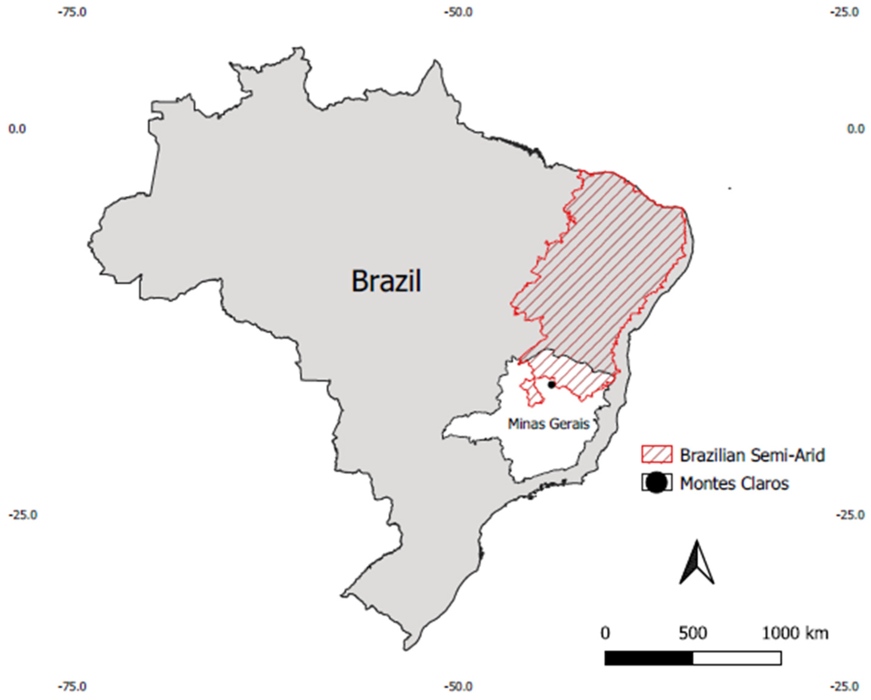
2.1. Local Settings
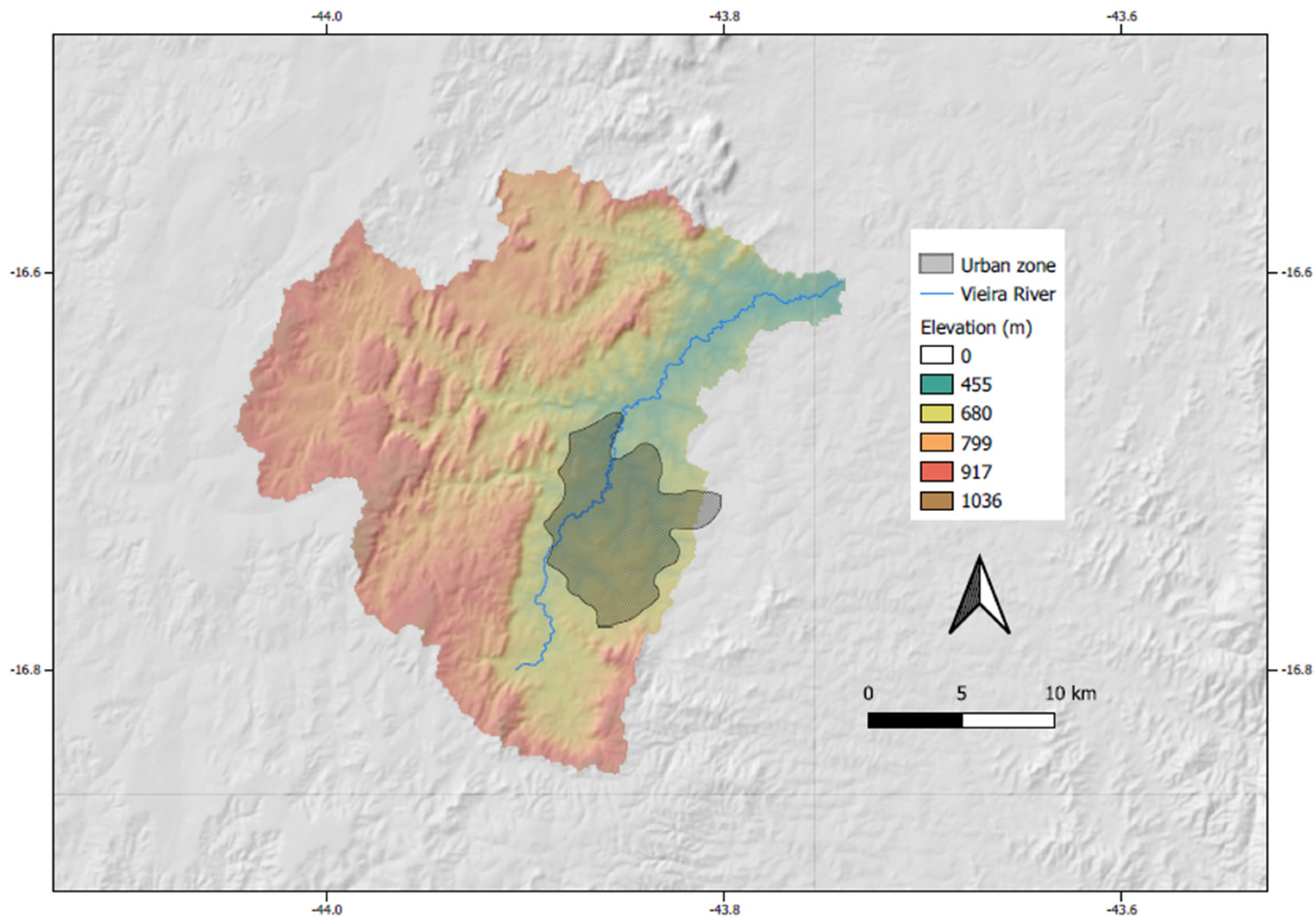
2.2. Physiographic Features
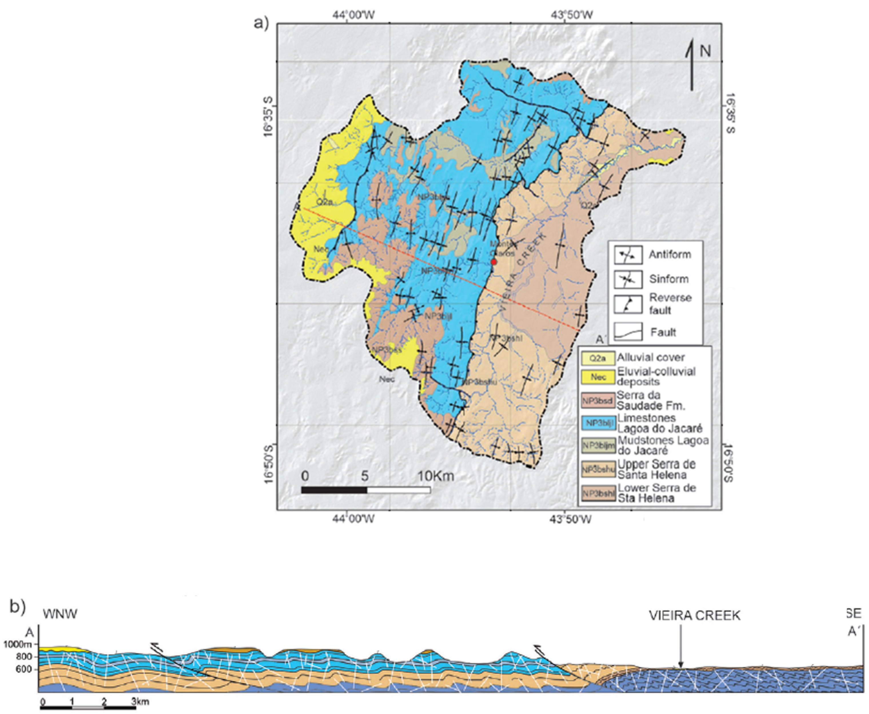
2.3. Geological Context
2.4. Hydrogeology
3. Methodology
3.1. Topography
3.2. Geological Model
3.3. Hydrogeological Information
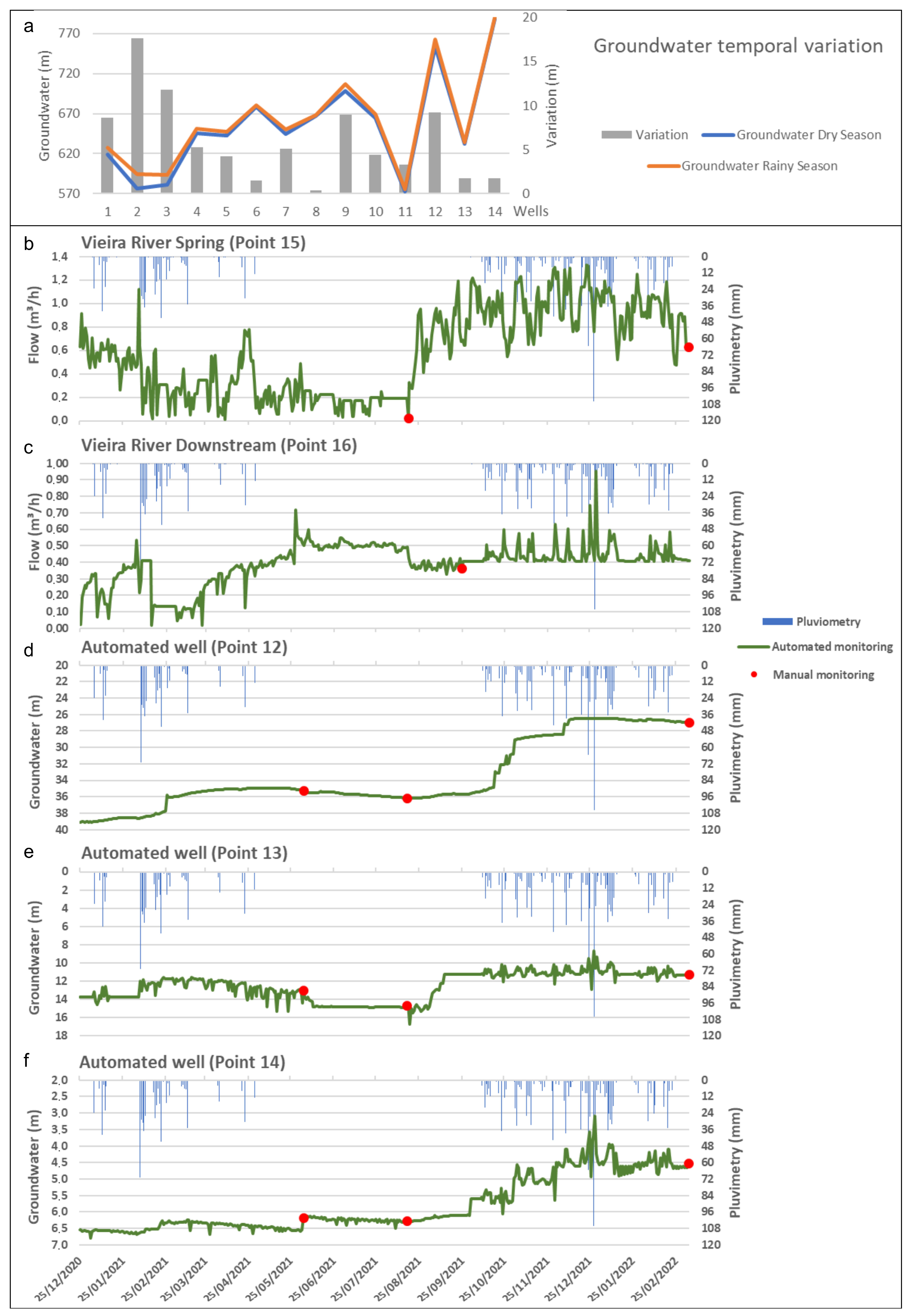
3.4. Groundwater Monitoring
3.5. Conceptual and Numerical Model and Parametrization
- s: medium saturation;
- So: specific storage;
- ψ: hydraulic head;
- ε: saturation adjustment coefficient over time;
- ∂ψ/∂t: variation of hydraulic head;
- ∂s/∂t: variation of saturation;
- ∇⋅q: gradient of the flux vector q;
- Q: generic source or sink function;
- QEOB: source/sink correction term of the extended Oberbeck–Boussinesq approximation.
3.5.1. Mesh
- The upper limit corresponds to the topographic surface, covering an area of approximately 579 km2;
- The model assumes a thickness of approximately 840 m (i.e., groundwater depth);
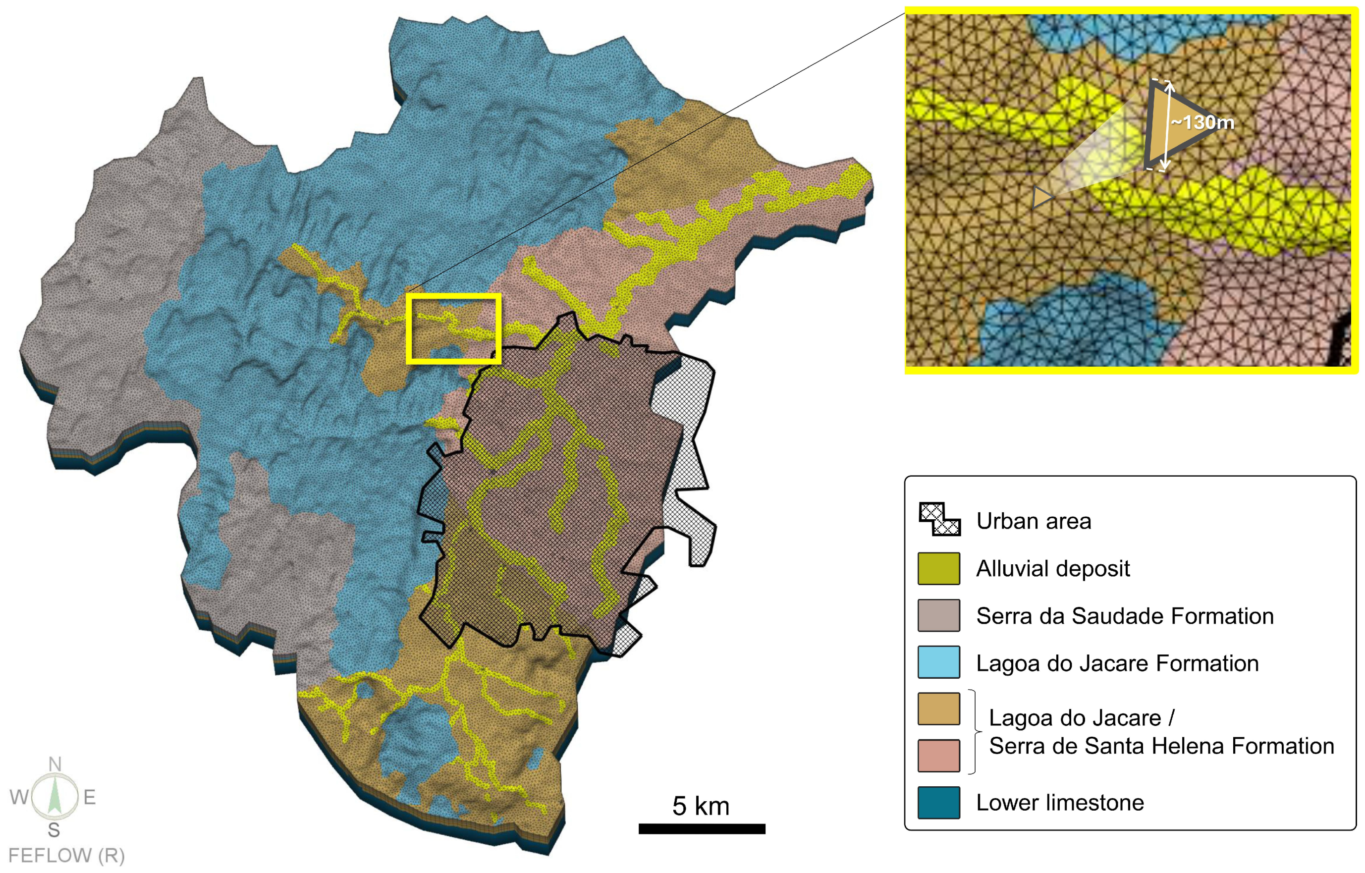
- The calculation grid represents the geometry of the hydrogeological system, as well as fault structures and drilled wells.
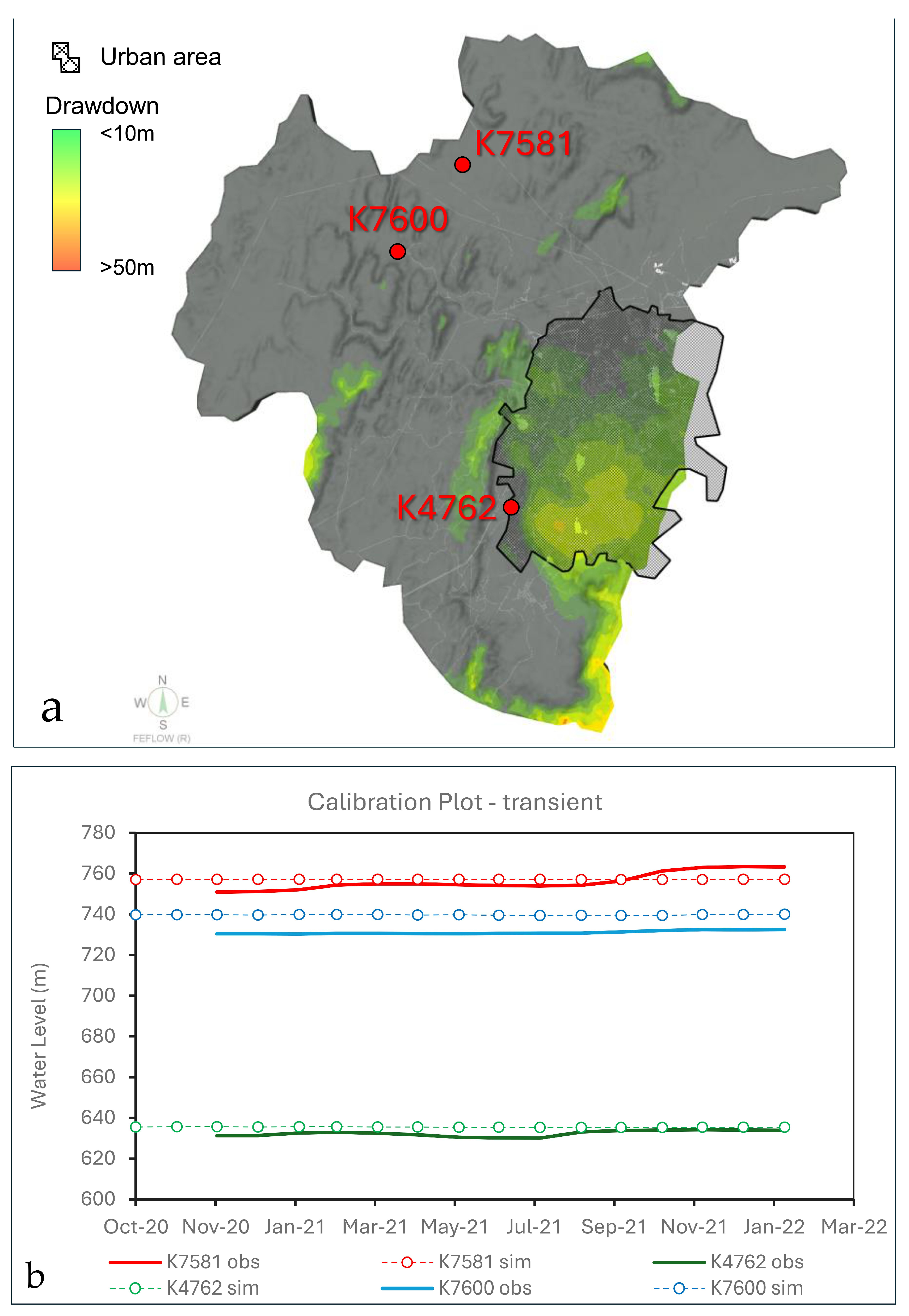
3.5.2. Boundary Conditions, Parametrization, Groundwater Recharge, and Calibration
- Altitude (A): Refers to the elevation of the terrain. The lowest point of the basin was used as a reference, as the Vieiras River is the base level of this basin and is located in a low-energy region in terms of surface flow. The minimum elevation of this point is approximately 585 m. Thus, two altitude zones were considered relative to the 585 m reference, following the original methodology. The first zone ranges from 0 to 300 m (585 to 885 m), and the second from 300 to 600 m (885 to 1185 m).
- Slope (Pendiete, P): Refers to the incline of the terrain. In the area, the maximum slopes reach 70%. In this study, the slope was the first parameter considered differently than in the original method. In the Vieiras River Basin, a significant geomorphological difference is observed between the river plain and the flow regions of its tributaries. The Vieiras River flows through a valley that has been leveled by erosive processes, with low slopes and differing geology. However, this region consists of metapelitic rocks of the Lagoa do Jacaré Formation and mainly from the Serra de Santa Helena Formation, being very close to the local base level. This could indicate a low infiltration potential, mainly due to the permeability characteristics of this lithology. Therefore, adaptations were made in the region, associating a correction factor. To delineate the topographic zones of higher from those with lower altitude, the Terrain Segmentation tool of SAGA GIS was used (Figure 9). This tool divides an area into segments or regions with similar characteristics and is frequently applied in GIS analyses.
- Lithology (L): Refers to the geological composition of the terrain. The classification is based on local geological, geomorphological, and hydrogeological maps, as well as field inspections and observations. In this study, values corresponding with or similar to those proposed in the original method were used.
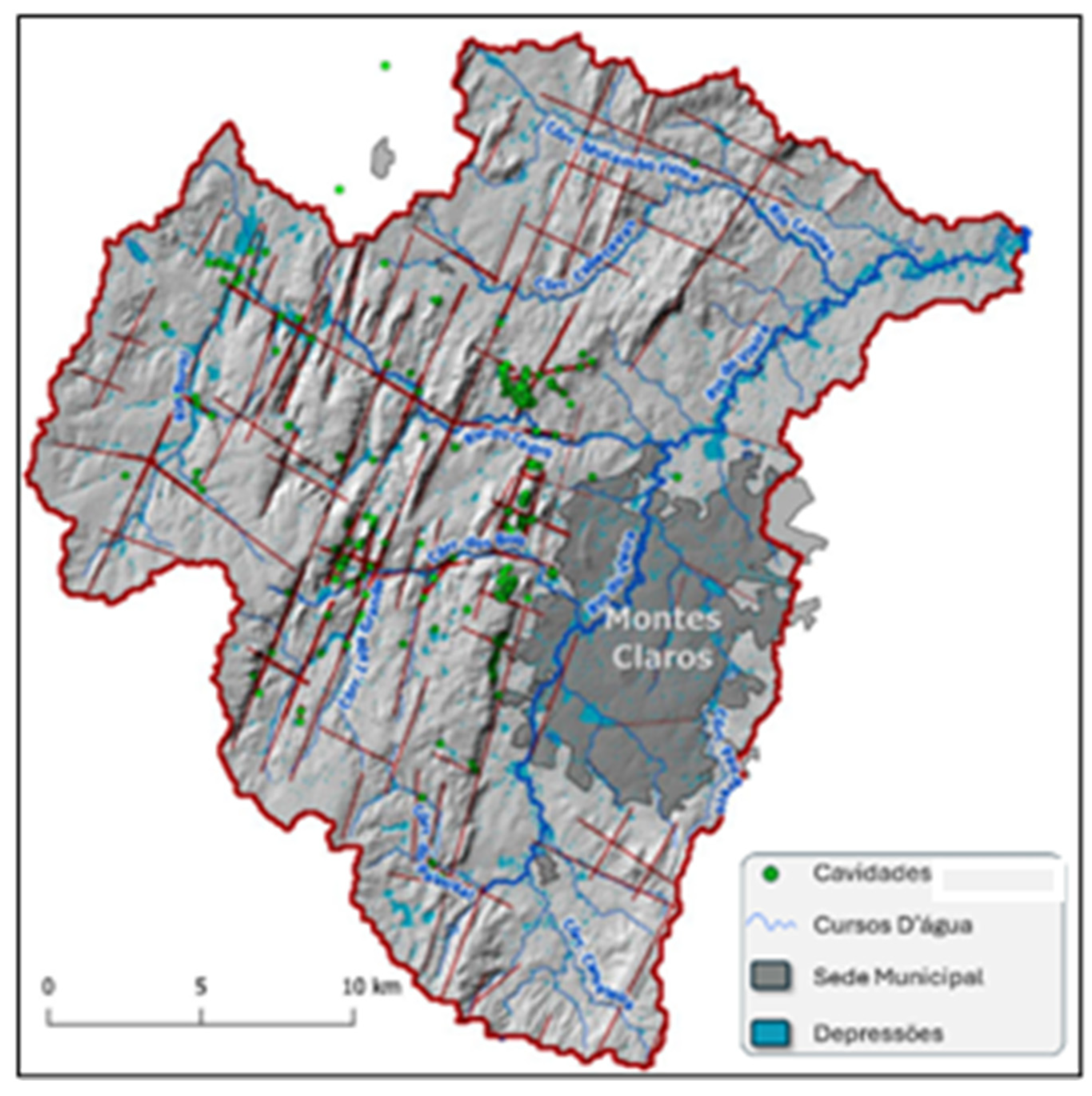
- Infiltration (I): Determined by observing preferential infiltration pathways in the field, such as major faults, fault-controlled valleys, and karst features, among others. In addition to mapping the main lineaments and features and interpreting them in a GIS environment, the Peak and Depressions algorithm from Surfer® software version 26 was used. This tool analyzes and identifies the highest (peaks) and lowest (depressions) points on a surface map, such as a DEM or another type of grid map, and is widely used in geology, geomorphology, environmental studies, and territorial planning. Polygons identified as depressions, generated from this tool, were used as preferential recharge points. Another important factor identified in the preferential infiltration zones was the presence of lineaments, which were inserted by constructing a density map (Figure 10). Kernel analysis was performed on the DEM (QGIS), with a search radius of 300 m, considering three average thickness values of 10, 80, and 200 m. These values were used to assign weights to the structures when constructing the lineament density map, with a weight of 1 for 10 m, 8 for 80 m, and 20 for 200 m drainages. Karst features extracted from Ref. [46] were also assigned a score of 20 within a 200 m radius for cavity protection areas, while non-carbonate rocks (mainly metapelites from the Serra da Saudade, Lagoa do Jacaré, and Serra da Santa Helena Formations) were given reduced scores that were gradually increased for the rocks of the Lagoa do Jacaré Formation, especially for the limestones. The estimated density analysis varied between 0 and 0.07 m/m2. This lineament density data was aggregated with the depressions map and normalized on a scale from 1 to 10.
- Soil Type (S): Parameters were assumed based on the original values of the method. The soil map presented in the area’s characterization was used as the base, obtained from studies by Ref. [47]. Some soil classes, such as haplic nitisols, are not found in the original method [41]. In this case, data from Ref. [15] were used and correlated based on the average K value.
3.6. Climate Change Scenarios
- SSP1-2.6 (optimistic scenario, with low greenhouse gas emissions);
- SSP2-4.5 (stabilization scenario);
- SSP3-7.0 (intermediate scenario);
- SSP-8.5 (pessimistic scenario, with high greenhouse gas emissions).
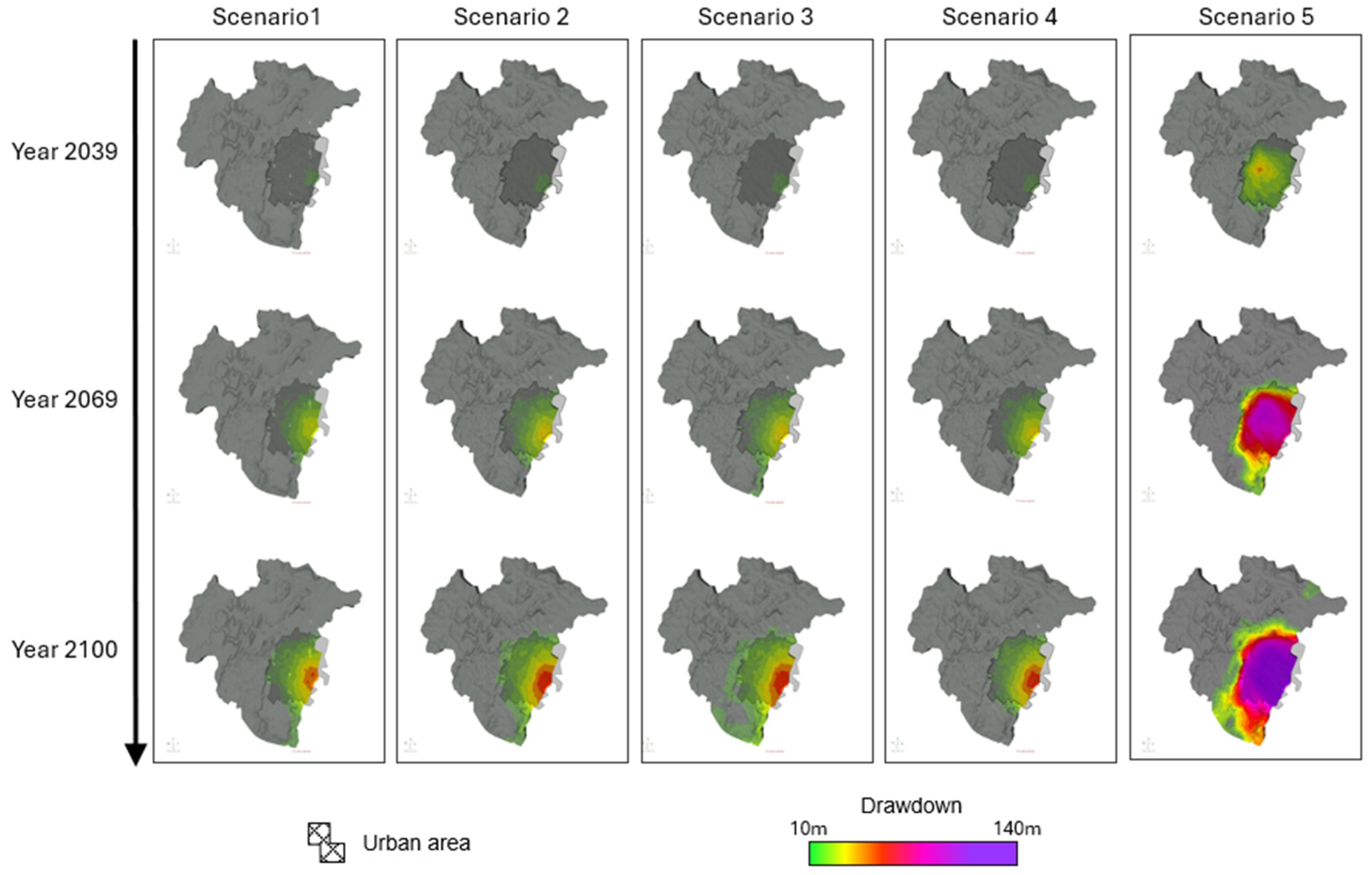
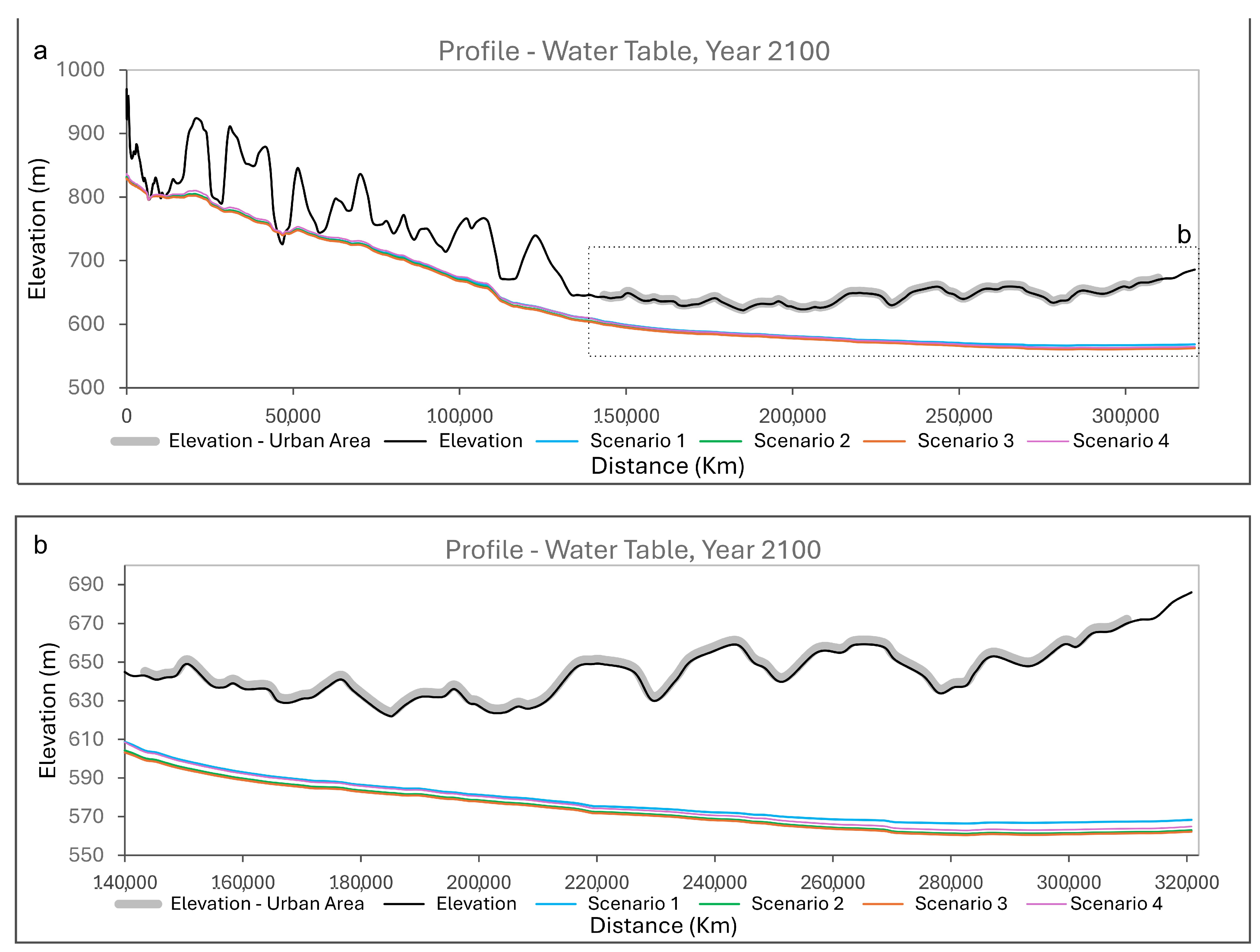
- Scenario 1: 10% reduction in rainfall by 2100, with no increase in groundwater consumption. Adapted from SSP5-8.5 [54];
- Scenario 2: 10% reduction in rainfall by 2100, with an increase in groundwater consumption proportional to that in recent decades. Adapted from SSP5-8.5 [54];
- Scenario 3: 9.5%, 16.5%, and 25% reduction in rainfall for the periods up to 2039, between 2040 and 2069, and from 2070 to 2100, respectively, considering population growth. Adapted from Scenario B1 [51];
- Scenario 4: 16%, 28%, and 12.5% increase in rainfall for the periods up to 2039, between 2040 and 2069, and from 2070 to 2100, respectively, considering population growth. Adapted from Scenario A2 [51].
4. Results and Discussion
5. Conclusions
Author Contributions
Funding
Data Availability Statement
Conflicts of Interest
References
- Schirmer, M.; Leschik, S.; Musolff, A. Current research in urban hydrogeology—A review. Adv. Water Resour. 2013, 51, 280–291. [Google Scholar] [CrossRef]
- Gharib, A.A.; Blumberg, J.; Manning, D.T.; Goemans, C.; Arabi, M. Assessment of vulnerability to water shortage in semi-arid river basins: The value of demand reduction and storage capacity. Sci. Total. Environ. 2023, 871, 161964. [Google Scholar] [CrossRef]
- Liu, Z.; Zhou, J.; Yang, X.; Zhao, Z.; Lv, Y. Research on Water Resource Modeling Based on Machine Learning Technologies. Water 2024, 16, 472. [Google Scholar] [CrossRef]
- Herrera-Pantoja, M.; Hiscock, K.M. Projected Impacts of Climate Change on Water Availability Indicators in a Semi-arid Region of Central Mexico. Environ. Sci. Pol. 2012, 54, 81–89. [Google Scholar] [CrossRef]
- Rugel, K.; Golladay, S.W.; Jackson, C.R.; Rasmussen, T.C. Delineating groundwater/surface water interaction in a karst watershed: Lower Flint River Basin, southwestern Georgia, USA. J. Hydrol. Reg. Stud. 2016, 5, 1–19. [Google Scholar] [CrossRef]
- Kahil, M.T.; Dinar, A.; Albiac, J. Modeling water scarcity and droughts for policy adaptation to climate change in arid and semiarid regions. J. Hydrol. 2015, 522, 95–109. [Google Scholar] [CrossRef]
- Li, P.; Wu, J. Water Resources and Sustainable Development. Water 2024, 16, 134. [Google Scholar] [CrossRef]
- Ford, D.; Williams, P. Karst Hydrogeology and Geomorphology; John Wiley and Sons, Ltd.: Chichester, UK, 2007; p. 562. [Google Scholar]
- Kalhor, K.; Ghasemizadeh, R.; Rajic, L.; Alshawabkeh, A. Assessment of groundwater quality and remediation in karst aquifers: A review. Groundw. Sustain. Dev. 2019, 8, 104–121. [Google Scholar] [CrossRef]
- Auler, A.S. Karst Evolution and Palaeoclimate of Eastern Brazil. Ph.D. Thesis, University of Bristol, Bristol, UK, 1999. [Google Scholar]
- Kaufmann, G. Modelling unsaturated flow in an evolving karst aquifer. J. Hydrol. 2003, 276, 53–70. [Google Scholar] [CrossRef]
- Bakalowicz, M. Karst groundwater: A challenge for new resources. Hydrog. J. 2005, 13, 148–160. [Google Scholar] [CrossRef]
- Galvão, P.; Hirata, R.; Cordeiro, A.; Barbati, D.; Penaranda, J. Geologic conceptual model of the municipality of Sete Lagoas (MG, Brazil) and the surroundings. Anais Acad. Bras. Ciên. 2016, 88, 35–53. [Google Scholar] [CrossRef] [PubMed]
- Hidrogeologia dos Ambientes Cársticos da Bacia do Rio São Francisco para a gestão de recursos hídricos, Agência Nacional de Águas (ANA). Available online: https://metadados.snirh.gov.br/geonetwork/srv/por/catalog.search#/metadata/11828587-8176-4eb9-a367-0e4cdf9b2e3d (accessed on 26 April 2023).
- Projeto Águas do Norte de Minas—PANM: Estudo da Disponibilidade Hídrica Subterrânea do Norte de Minas Gerais. Serviço Geológico do Brasil (CPRM). Available online: https://www.sgb.gov.br/panm (accessed on 5 September 2024).
- Souza, M.; Oliveira, S.; Paixão, M.; Haussmann, M. Aspectos Hidrodinâmicos e Qualidade Das Águas Subterrâneas Do Aquífero Bambuí No Norte de Minas Gerais. Rev. Bras. Recur. Hídricos 2014, 19, 119–129. [Google Scholar] [CrossRef]
- Muniz, G.L.; Oliveira, A.L.G.; Benedito, M.G.; Cano, N.D.; Camargo, A.P.d.; Silva, A.J.d. Risk Evaluation of Chemical Clogging of Irrigation Emitters via Geostatistics and Multivariate Analysis in the Northern Region of Minas Gerais, Brazil. Water 2023, 15, 790. [Google Scholar] [CrossRef]
- Leite, M.E. Geoprocessamento aplicado ao estudo do espaço urbano: O caso da cidade de Montes Claros/MG. Master’s Thesis, Universidade Federal de Uberlândia, Uberlândia, Brazil, 2006, unpublished. [Google Scholar]
- Leite, M.E.; Santos, I.S.; Almeida, J.W.L. Mudança de Uso do Solo na Bacia do Rio Vieira, em Montes Claros/MG. Ver. Bras. Geogr. Fís. 2011, 4, 779–792. [Google Scholar]
- Bhering, A.P.; Antunes, I.M.H.R.; Marques, E.A.G.; de Paula, R.S.; Silva, A.R.N. Hydrogeology of Karst and Metapelitic Domains of the Semi-Arid Vieira River Watershed (Brazil)—A Contribution to Groundwater Resource Management. Water 2023, 15, 2066. [Google Scholar] [CrossRef]
- Almeida, F.F.M. O Cráton do São Francisco. Ver. Bras. Geoc. 1977, 7, 349–364. [Google Scholar]
- Alkmim, F.F.; Martins-Neto, M.A. Proterozoic first-order sedimentary sequences of the São Francisco craton, eastern Brazil. Mar. Pet. Geol. 2012, 33, 127–139. [Google Scholar] [CrossRef]
- Caxito, F.A.; Frei, R.; Uhlein, G.J.; Dias, T.G.; Árting, T.B.; Uhlein, A. Multiproxy geochemical and isotope stratigraphy records of a Neoproterozoic Oxygenation Event in the Ediacaran Sete Lagoas cap carbonate, Bambuí Group, Brazil. Chem. Geol. 2018, 481, 119–132. [Google Scholar] [CrossRef]
- Martins-Neto, M.A.; Pedrosa-Soares, A.C.; Lima, S.A.A. Tectono-sedimentary evolution of sedimentary basins from Late Paleoproterozoic to Late Neoproterozoic in the São Francisco craton and Araçuaí fold belt, eastern Brazil. Sediment. Geol. 2001, 141–142, 343–370. [Google Scholar] [CrossRef]
- Dardenne, M.A. Síntese sobre a estratigrafia do Grupo Bambuí no Brasil Central. In Proceedings of the 30th Congresso Brasileiro de Geologia, Recife, Brazil, November 1978; Available online: https://www.sbgeo.org.br/home/pages/33 (accessed on 2 October 2024).
- Projeto Norte de Minas. Available online: http://www.portalgeologia.com.br/index.php/mapa/ (accessed on 27 April 2023).
- Sistema de Informações de Águas Subterrâneas (SIAGAS), Brazilian Geological Survey (CPRM). Available online: https://siagasweb.sgb.gov.br/layout/ (accessed on 1 July 2020).
- Chaves, M.L.S.; Andrade, K.W. Folha Coração de Jesus 1:100.000. Projeto Norte de Minas, Belo Horizonte, Programa Mapeamento Geológico do Estado de Minas Gerais, Convênio CPRM-IGC/UFMG. Available online: http://www.portalgeologia.com.br/index.php/mapa/ (accessed on 27 April 2023).
- Chaves, M.L.S.; Andrade, K.W. Folha Montes Claros 1:100.000. Brasília, Programa Geologia do Brasil, Convênio CPRM-IGC/UFMG. Available online: https://geosgb.sgb.gov.br/ (accessed on 27 April 2023).
- Bhering, A.P.; Antunes, I.M.H.R.; Marques, E.A.G.; Paula, R.S. Geological and Hydrogeological review of a semi-arid region with conflicts to water availability (Southeastern Brazil). Environ. Res. 2021, 202, 111756. [Google Scholar] [CrossRef]
- Cavalcanti, J.A.D. Neoproterozoic-Cambrian structures as a guide to the evolution of the Bambui Karst in the Vieira river basin, Montes Claros, North of Minas Gerais, Brazil. J. Geol. Surv. Braz. 2022, 5, 21–47. [Google Scholar] [CrossRef]
- Cadastro Nacional de Informações Espeleológicas (CANIE) do Centro Nacional de Pesquisa e Conservação de Cavernas (CECAV). Available online: http://www.icmbio.gov.br/cecav/canie.html (accessed on 31 January 2020).
- TOPODATA—Banco de dados geomorfométricos do Brasil. Available online: http://www.dsr.inpe.br/topodata/ (accessed on 2 October 2024).
- Diersch, H.-J.G. FEFLOW: Finite Element Modeling of Flow, Mass and Heat Transport in Porous and Fractured Media; Springer: Berlin/Heidelberg, Germany, 2014. [Google Scholar] [CrossRef]
- Paula, R.S.d. Modelo Conceitual de Fluxo dos Aquíferos Pelíticos-Carbonáticos da Região da APA Carste de Lagoa Santa, MG. PhD. Thesis, Universidade Federal de Minas Gerais, Belo Horizonte, Brazil, 2019. [Google Scholar]
- White, W.B. A brief history of karst hydrogeology: Contributions of the NSS. J. Cave Karst Stud. 2007, 69, 13–26. [Google Scholar]
- Scanlon, B.R.; Mace, R.E.; Barret, M.E.; Smith, B. Can we simulate regional groundwater flow in a karst system using equivalent porous media models? Case study, Barton Springs Edwards aquifer, USA. J. Hydrol. 2003, 276, 137–158. [Google Scholar] [CrossRef]
- Paula, R.S.d.; Velásquez, L.N.M. Modelagem Numérica de Fluxo de um Aquífero Cárstico-Fissural da bacia do Riacho Boi Morto no Município de São Francisco, Minas Gerais. Rev. Águas Subterrâneas 2013, 27, 66–78. [Google Scholar] [CrossRef]
- Razack, M.; Huntley, D. Assessing transmissivity from specific capacity in a large and heterogeneous alluvial aquifer. Groundwater 1991, 29, 856–861. [Google Scholar] [CrossRef]
- Pena, M.A.C.; Velásquez, L.N.M.; Teixeira, G.M.; Silva, P.H.P.d.; Amaral, D.G.P.; Paula, R.S.d. Análise de lineamentos e sua relação com a capacidade específica de poços na APA Carste de Lagoa Santa, MG. Águas Subterrâneas 2021. Available online: https://aguassubterraneas.abas.org/asubterraneas/article/view/29816 (accessed on 2 October 2024).
- Andreo, B.; Vías, J.; Durán, J.J.; Jiménez, P.; López-Geta, J.A.; Carrasco, F. Methodology for groundwater recharge assessment in carbonate aquifers: Application to pilot sites in southern Spain. Hydrog. J. 2008, 16, 911–925. [Google Scholar] [CrossRef]
- Marín, A.I. Los sistemas de información geográfica aplicados a la evaluación de recursos hídricos y a la vulnerabilidad a la contaminación de acuíferos carbonatados. Caso de la Alta Cadena (Provincia de Málaga). Bachelor’s Thesis, University of Malaga, Malaga, Spain, 2009. [Google Scholar]
- Hartmann, A.; Goldscheider, N.; Wagener, T.; Lange, J.; Weiler, M. Karst water resources in a changing world: Review of hydrological modeling approaches. Rev. Geophys. 2014, 52, 218–242. [Google Scholar] [CrossRef]
- Farfán, H.; Corvea, J.; de Bustamante, I. Sensitivity Analysis of APLIS Method to Compute Spatial Variability of Karst Aquifers Recharge at the National Park of Viñales (Cuba). In Advances in Research in Karst Media; Andreo, B., Carrasco, F., Durán, J., LaMoreaux, J., Eds.; Springer: Berlin/Heidelberg, Germany, 2010; pp. 14–24. [Google Scholar] [CrossRef]
- Espinoza, K.; Marina, M.; Fortuna, J.H.; Altamirano, F. Comparison of the APLIS and Modified-APLIS Methods to Estimate the Recharge in Fractured Karst Aquifer, Amazonas, Peru. In Hydrogeological and Environmental Investigations in Karst Systems; Andreo, B., Carrasco, F., Durán, J., Jiménez, P., LaMoreaux, J., Eds.; Springer: Berlin/Heidelberg, Germany, 2015; Volume 1, pp. 83–90. [Google Scholar] [CrossRef]
- Instituto Mineiro de Gestão das Águas. Available online: http://www.igam.mg.gov.br/ (accessed on 20 September 2024).
- Mapa de Solos do Estado de Minas Gerais (1:650.000). Available online: https://dps.ufv.br/softwares/ (accessed on 20 September 2024).
- Teixeira, G.M.; de Paula, R.S.; Velasquez, L.N.M.; Andrade, I.B.; Neto, W.M.P. Evaluation of recharge estimation methods applied to fissure and karst aquifers of the Lagoa Santa Karst Environmental Protection Area, Brazil. Hydrol. Process. 2023, 37, e14971. [Google Scholar] [CrossRef]
- Anderson, M.P.; Woessner, W.W.; Hunt, R.J. Applied Groundwater Modeling: Simulation of Flow and Advective Transport, 2nd ed.; Elsevier: London, UK, 2015. [Google Scholar] [CrossRef]
- Krol, M.; Jaeger, A.; Bronstert, A.; Güntner, A. Integrated modelling of climate, water, soil, agricultural and socio-economic processes: A general introduction of the methodology and some exemplary results from the semi-arid north-east of Brazil. J. Hydrol. 2006, 328, 417–431. [Google Scholar] [CrossRef]
- Montenegro, S.; Ragab, R. Impact of a possible climate and land use changes in the semi arid regions: A case study from North Eastern Brazil. J. Hydrol. 2012, 434, 55–68. [Google Scholar] [CrossRef]
- Lacerda, F.F.; Nobre, P.; Sobral, M.C.M.; Lopes, G.M.B.; Assad, E.D. Tendência do clima do semiárido frente as perspectivas das mudanças climáticas globais; o caso de Araripina, Pernambuco. Rev. Dep. Geogr. 2016, 31, 132–141. [Google Scholar] [CrossRef]
- Fan, X.; Duan, Q.; Shen, C.; Wu, Y.; Xing, C. Global surface air temperatures in CMIP6: Historical performance and future changes. Environ. Res. Lett. 2020, 15, 104056. [Google Scholar] [CrossRef]
- Dantas, L.G.; dos Santos, C.A.C.; Santos, C.A.G.; Martins, E.S.P.R.; Alves, L.M. Future Changes in Temperature and Precipitation over Northeastern Brazil by CMIP6 Model. Water 2022, 14, 4118. [Google Scholar] [CrossRef]
- Wang, H.; Li, Y.; Wang, E.; Zhao, Z. Strategic ground water management for the reduction of karst land collapse hazard in Tangshan, China. Eng. Geol. 2007, 48, 135–148. [Google Scholar] [CrossRef]
- Salvati, R.; Sasowsky, I.D. Development of collapse sinkholes in areas of groundwater discharge. J. Hydrol. 2002, 264, 1–11. [Google Scholar] [CrossRef]
- Galvão, P.H.F. Hydrogeological Conceptual Model of Sete Lagoas (MG) and Associated Implications of Urban Development in Karst Region. Ph.D. Thesis, Universidade de São Paulo, São Paulo, Brazil, 2015. [Google Scholar]




| Geological Unit | KX | KY | KZ | So | ε |
|---|---|---|---|---|---|
| Alluvial deposits | 9.00 × 10⁶ | 1.08 × 10⁵ | 9.00 × 10⁷ | 1.00 × 10⁴ | 2.50 × 101 |
| Soil | 1.04 × 10⁶ | 1.10 × 10⁶ | 5.79 × 10⁸ | 5.00 × 10⁵ | 1.00 × 10² |
| Lower limestone | 1.16 × 10⁶ | 2.31 × 10⁶ | 1.16 × 10⁷ | 1.00 × 10³ | 2.50 × 101 |
| Siltstone | 9.26 × 10⁷ | 1.10× 10⁶ | 1.04 × 10⁷ | 1.00 × 10⁶ | 6.00 × 10³ |
| Limestone | 2.80 × 10⁶ | 3.36 × 10⁶ | 2.80 × 10⁷ | 8.00 × 10⁵ | 1.60 × 101 |
| Contact zones | 3.47 × 10⁵ | 3.47 × 10⁵ | 3.47 × 10⁵ | 5.00 × 10⁴ | 2.00 × 101 |
Disclaimer/Publisher’s Note: The statements, opinions and data contained in all publications are solely those of the individual author(s) and contributor(s) and not of MDPI and/or the editor(s). MDPI and/or the editor(s) disclaim responsibility for any injury to people or property resulting from any ideas, methods, instructions or products referred to in the content. |
© 2024 by the authors. Licensee MDPI, Basel, Switzerland. This article is an open access article distributed under the terms and conditions of the Creative Commons Attribution (CC BY) license (https://creativecommons.org/licenses/by/4.0/).
Share and Cite
Pedrosa Bhering, A.; Antunes, I.M.H.R.; Nascimento Catão, G.; Gomes Marques, E.A.; de Paula, R.S.; Brito Andrade, I.; Rebelo Diório, G. Groundwater Model for Karst and Pelitic Aquifer Systems from a Semi-Arid Region Under Climate Change Scenarios: A Case Study in the Vieira River Watershed, Brazil. Water 2024, 16, 3140. https://doi.org/10.3390/w16213140
Pedrosa Bhering A, Antunes IMHR, Nascimento Catão G, Gomes Marques EA, de Paula RS, Brito Andrade I, Rebelo Diório G. Groundwater Model for Karst and Pelitic Aquifer Systems from a Semi-Arid Region Under Climate Change Scenarios: A Case Study in the Vieira River Watershed, Brazil. Water. 2024; 16(21):3140. https://doi.org/10.3390/w16213140
Chicago/Turabian StylePedrosa Bhering, Apolo, Isabel Margarida Horta Ribeiro Antunes, Gustavo Nascimento Catão, Eduardo Antonio Gomes Marques, Rodrigo Sergio de Paula, Isabella Brito Andrade, and Giovana Rebelo Diório. 2024. "Groundwater Model for Karst and Pelitic Aquifer Systems from a Semi-Arid Region Under Climate Change Scenarios: A Case Study in the Vieira River Watershed, Brazil" Water 16, no. 21: 3140. https://doi.org/10.3390/w16213140
APA StylePedrosa Bhering, A., Antunes, I. M. H. R., Nascimento Catão, G., Gomes Marques, E. A., de Paula, R. S., Brito Andrade, I., & Rebelo Diório, G. (2024). Groundwater Model for Karst and Pelitic Aquifer Systems from a Semi-Arid Region Under Climate Change Scenarios: A Case Study in the Vieira River Watershed, Brazil. Water, 16(21), 3140. https://doi.org/10.3390/w16213140


