Article

Stability of Loess Slopes Under Different Plant Root Densities and Soil Moisture Contents

1
Technology Innovation Center for Land Engineering and Human Settlements, Shaanxi Land Engineering Construction Group Co., Ltd., School of Human Settlements and Civil Engineering, Xi’an Jiaotong University, Xi’an 710075, China
2
Shaanxi Provincial Land Engineering Construction Group, Land Engineering Technology Innovation Center, Ministry of Natural Resources, Xi’an 710075, China
3
Shaanxi Provincial Land Engineering Construction Group, Key Laboratory of Degraded and Unused Land Consolidation Engineering, Ministry of Natural Resources, Xi’an 710075, China
4
Institute of Land Engineering and Technology, Shaanxi Provincial Land Engineering Construction Group Co., Ltd., Key Laboratory of Cultivated Land Quality Monitoring and Conservation, Ministry of Agriculture and Rural Affairs, Xi’an 710075, China
5
Zhejiang Academy of Surveying and Mapping, Hangzhou 317299, China
6
Research Center of Soil and Water Conservation and Ecological Environment, Chinese Academy of Sciences and Ministry of Education, Xianyang 712100, China
7
Institute of Soil and Water Conservation, Chinese Academy of Sciences and Ministry of Water Resources, Xianyang 712100, China
*
Authors to whom correspondence should be addressed.
Water 2024, 16(24), 3558; https://doi.org/10.3390/w16243558
Submission received: 23 October 2024 / Revised: 2 December 2024 / Accepted: 10 December 2024 / Published: 10 December 2024
(This article belongs to the Special Issue Soil Erosion and Soil and Water Conservation)

Abstract

:
This study conducted an in-depth analysis of the landslide problem in the loess hill and gully area in northern Shaanxi Province, selecting the loess landslide site in Quchaigou, Ganquan County, Yan’an City, as the object to assess the stability of loess slopes under the conditions of different plant root densities and soil moisture contents through field investigation, physical mechanics experiments and numerical simulation of the GeoStudio model. Periploca sepium, a dominant species in the plant community, was selected to simulate the stability of loess slope soils under different root densities and soil water contents. The analysis showed that the stability coefficient of Periploca sepium natural soil root density was 1.263, which was a stable condition, but the stability of the stabilized slopes decreased with the increase in soil root density. Under the condition of 10% soil moisture content, the stability coefficient of the slope body is 1.136, which is a basic stable state, but with the increase in soil moisture content, the stability of the stable slope body decreases clearly. The results show that rainfall and human activities are the main triggering factors for loess landslides, and the vegetation root system has a dual role in landslide stability: on the one hand, it increases the soil shear strength, and on the other hand, it may promote water infiltration and reduce the shear strength. In addition, the high water-holding capacity and permeability anisotropy of loess may lead to a rapid increase in soil deadweight under rainfall conditions, increasing the risk of landslides. The results of this study are of great significance for disaster prevention and mitigation and regional planning and construction, and they also provide a reference for landslide studies in similar geological environments.

1. Introduction

Landslide is a natural phenomenon in which the rock and soil body of a slope is destabilized under the action of gravity and slides down the slope [1,2]. The northern part of Shaanxi Province, as the central accumulation area of the Loess Plateau, covers a wide area of loess [3,4,5]. The region is characterized by long gullies, dense river networks and poor geological and environmental conditions, which are susceptible to the erosive effects of rainfall and human engineering activities during the rainy season [6,7,8], leading to frequent geological disasters and seriously threatening the safety of people’s lives and property and economic development. There are many triggering factors for loess landslides [9,10], among which rainfall and human activities are the most important [11,12]. Rainfall greatly changes the soil water content, leading to the collapse of the loess slope [13]. Tree planting, engineering excavation and other human activities have changed the soil structure of loess slopes, leading to their instability [14,15]. At present, there is a lack of comprehensive research on the triggering factors and development conditions of loess landslides, especially in this region of China, where the study of geological hazards started late [16,17]. Current researchers are mainly focused on studying the distribution pattern of loess landslides [18], statistically analyzing the characteristics of the spatial distribution of landslide disaster points and regionally delineating the types of landslide disasters and other aspects of their occurrence [19,20,21].
Stability prediction of loess landslides is an important part of disaster monitoring and early warning [22], which is of great significance for disaster prevention and mitigation and regional planning and construction [23,24]. Landslide stability assessment is generally divided into qualitative and quantitative assessment [25]. The qualitative assessment method is mainly based on the personal experience of experts, combined with the geological and geomorphological characteristics of historical landslide sites, and there is strong subjectivity [26]. The quantitative assessment of slope stability now commonly used is the limit equilibrium method, where the static equilibrium conditions on the known slip surface are used to calculate the stability safety factor [27], to judge the stability of the landslide metrics and critical criteria [28].
At present, a national series of ecological restoration measures are being implemented for eolian hills and gullies [29], meaning the vegetation cover rate of loess hills and gullies is being significantly increased. This is prompting studies of the stability of eolian landslides given the change in the vegetation situation, which is often ignored in traditional eolian landslide prediction [30,31,32]. Empirical research has demonstrated that the root systems of vegetation enhance the shear strength of soil, thereby bolstering the stability of slopes. The augmentation of vegetation cover is instrumental in mitigating soil erosion and ameliorating the stability of shallow slopes [33]. Nevertheless, it is essential to acknowledge that the impact of vegetation root systems in enhancing the shear strength of deeper geotechnical strata is somewhat constrained [34]. The presence of these root systems can effectively create pore channels within the geotechnical mass, facilitating the infiltration of precipitation [35,36,37]. This process not only escalates the self-weight of the geotechnical mass but also diminishes its shear strength, potentially predisposing the area to deep-seated landslides [38,39,40]. While vegetation cover exerts a beneficial influence on slope stability within loess regions [41], its efficacy may be sensitive to the type of vegetation involved [42,43]. In certain scenarios, the root systems of vegetation have been observed to have a limited impact in augmenting the shear strength of deeper geotechnical bodies [44,45]. Loess, characterized by its loose and porous structure along with an impressive water-holding capacity, exhibits an anisotropic permeability. The vertical permeability of loess is markedly higher than its horizontal counterpart, implying that under rainfall conditions, the soil tends to percolate and retain more water, leading to a swift escalation in self-weight [32,46,47]. The proliferation of vegetation further amplifies the influence of rainfall infiltration on deadweight, attributable to an increased rate of rainfall infiltration and an enhanced soil water-holding capacity [48,49]. Consequently, to enhance the precision of predictions regarding the stability of loess slopes, it is imperative to consider the hydromechanical responses of loess to vegetation restoration [50,51].
Shaanxi Province has a wide distribution of loess area, which is seriously jeopardized by loess landslides. The landslide prediction mechanism as an effective disaster prevention and mitigation measure is extremely important for loess areas. The existing prediction methods are either costly or have poor accuracy as they ignore the spatial differences in vegetation and geo-engineering conditions, which makes it difficult to achieve the expected results in practice [52,53]. So, the study of loess slope stability under new geo-engineering conditions with the restoration of the vegetation environment is a priority for the current disaster prevention and control work [54,55]. Based on the hydrological and geomechanical characteristics of loess, this study introduces the dominant plant conditions in the study area, establishes a loess slope stability prediction model based on the GeoStudio model and investigates the stability of loess slopes under the conditions of different plant root densities and soil moisture contents, which means the prediction of the stability of loess landslides is more accurate and more easily extended to different scenarios. The results of this study show that stability prediction of loess landslides is an important part of disaster monitoring and early warning, which is of great significance for disaster prevention and mitigation, as well as regional planning and construction.

2. Materials and Methods

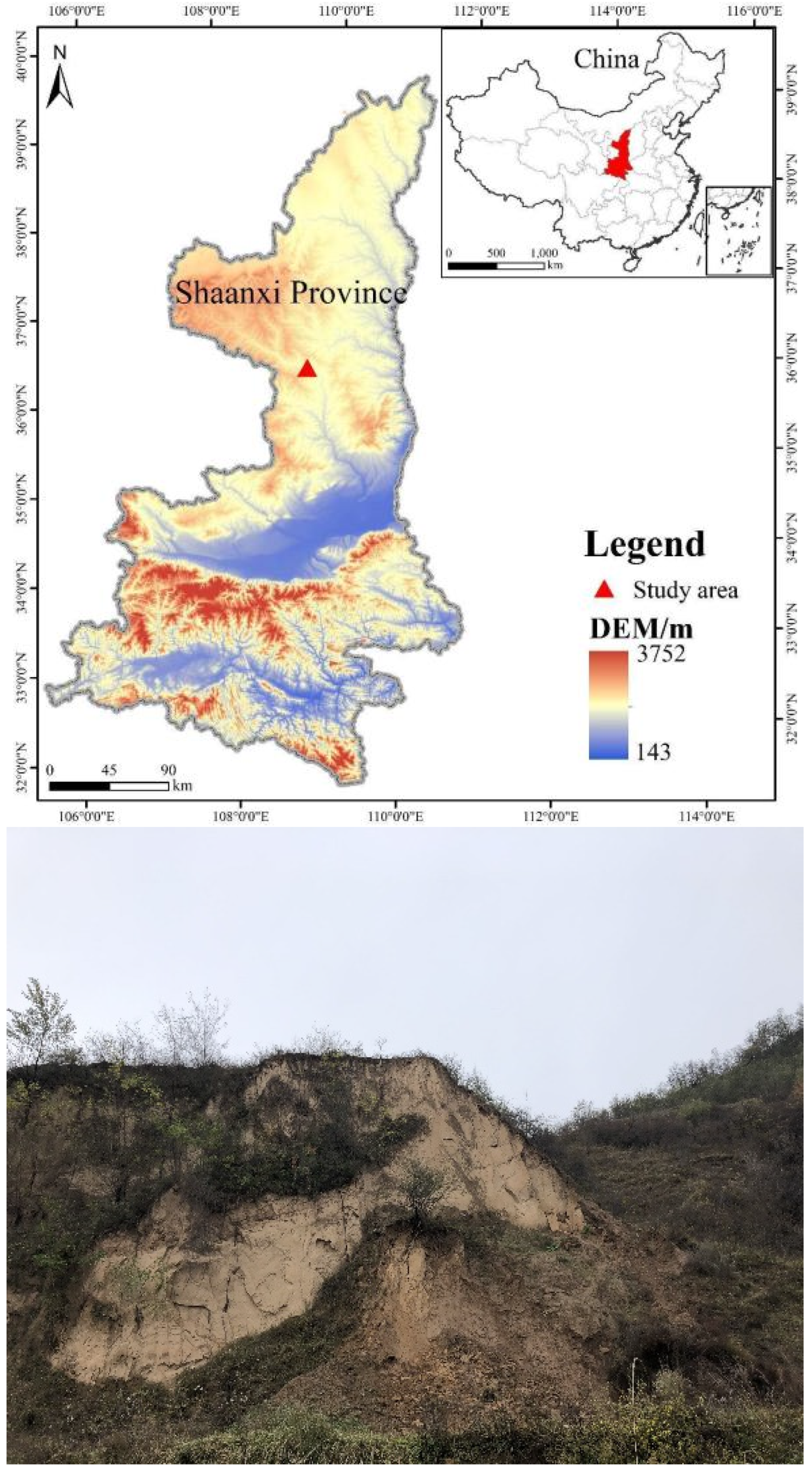
2.1. Overview of the Study Area

In this study, we examine a loess landslide in Qiangchaigou, Ganquan County, Yan’an City, Shaanxi Province, located in the village of Qiangchaigou, Shimen Township, which is an earthy landslide, with the coordinates of 109°09′22″ E longitude and 36°23′09″ N latitude (Figure 1). The study area has a semi-humid inland monsoon climate, with a large temperature difference between day and night, an average annual temperature of 8.6 °C, average sunshine of 6.8 h, an average annual frost-free period of 148 d and annual rainfall of 126.3 mm [56]. The soil types mainly include loess, chestnut calcareous soil, black clayey soil and grey calcareous soil. The study area is located in the southeast of the Ordos Basin Shanbei Slope, in the central part of the Shanbei Terrace Depression, which is mainly a sedimentary rock system of the Mesozoic Era [57].
The plan form of the landslide is semicircular, the profile form is convex, the overall slope is 33°, the direction of the landslide is due north, the length north–south is 130 m, the width east–west is 60 m, the elevation of the leading edge of the landslide is 1241 m, the elevation of the trailing edge is 1317.5 m, the relative difference in elevation is 76.5 m, the average thickness of the landslide is about 8 m and the volume is 5.2 × 10⁴ m3, making this a small landslide. The surface of the landslide is poorly covered by vegetation, with a river valley in front of the landslide, which is mainly arable land, and grassland in the rear, which grows poorly due to drought. The main reason for the occurrence of this landslide is the change in precipitation and vegetation root density; when the shear strength of the sliding body is less than the shear force, the structure of the sloping body is destroyed and the sloping body slides [58].

2.2. Sample Collection and Test

Consultation with nearby villagers revealed that the trees and shrubs growing in the landslide area were about seven years old at the time of this survey. During the field exploration, the researchers selected typical plant communities for sampling in the sample site area and developed sampling areas of 20 m × 20 m for the tree layer survey, 5 m × 5 m for the shrub layer and 1 m × 1 m for herbs [59]. For trees with heights greater than 1.5 m, a per-tree survey was conducted to record species names, heights and crowns; a per-tree survey was conducted for shrubs to record species names, cover, heights and the number of plants; and forbs were recorded as species names, cover, mean heights and multiple degrees. Following the sampling method described above, three each of tree, shrub and herb sample plots were randomly set up [60].
A 50 cm × 50 cm square soil profile was excavated 50 cm downslope from the base of the tree to collect samples of normal root growth and development and avoid the influence of mechanical force on the root system as much as possible in the collection process. Soil samples were collected using the profile method; in the vertical profile of each shrub sampling point, soil samples were taken every 10 cm in layers. The maximum sampling depth was 50 cm, and a mixed sampling method was used at the same soil depth. The soil samples were sealed and preserved in self-sealing bags [61]. The hydro-mechanical parameters of different types of plant rhizomatous soils were measured in the laboratory from the collected samples.
Three ring-knife samples were collected at each location of the landslide sampling, totaling 15 samples, and the density of the soil samples was determined by the ring-knife method. The ring-knife samples were weighed and then dried, and the dried soil samples were weighed again. The natural moisture content, natural density and dry density were calculated for each soil sample [62]. Saturated soil samples were prepared by the capillary saturation method [63]. The physical property indexes at each location were calculated by taking the average of the results of three ring-knife samples.
The shear strength of loess, which consists of cohesion and the angle of internal friction, is the main parameter for evaluating whether a landslide is stable or not [64]. The soil samples were remodeled according to the natural root density and 1.5 and 2 times the root density of the soil samples, and according to 10%, 20% and 30% soil moisture contents of the soil samples, and the cohesion and internal friction angle of the soil samples were determined in ring shear experiments using the experimental model SRS-150 Dynamic Ring Shear Apparatus produced by GCTS Company (Tempe, AZ, USA) [65].

2.3. Data Process

In this study, we classified the landslide hazardous sites in the area according to their vegetation characteristics and related engineering geological conditions, and through numerical simulation of typical hazardous sites, we coupled multiple rainfall scenarios with slope stability to derive the critical destabilization rainfall thresholds of landslides under multiple vegetation scenarios, which will be used as the threshold for forecasting and early warning [66].
The collected soil samples were dried and ground and then sieved through a 1 mm sieve, and the sieved soil samples were spread in non-absorbent aluminum disks and sprayed with the expected amount of water. The water addition was calculated using the following formula:
m w = m 1 + 0.01 w 0 0.01 ( w w 0 )
where mw is the amount of water required to be added to the soil sample (g), m is the mass of the soil sample at the air-dry moisture content (g), w0 is the air-dry moisture content (%) and w’ is the moisture content required for the design (%).
In this study, the two-dimensional slope simulation software GeoStudio 2018was used, which is a mature geotechnical software that has been widely used in scientific research and production. Its multi-module integration can couple the seepage conditions and stability of slopes for analysis, which was convenient for our study [67,68]. Based on the physical, hydrological and mechanical properties of the soil of the landslide body, the SLOPE-W module was used to model the landslide of Quchaigou in Ganquan County, Yan’an City, calculate the safety factor of the landslide, evaluate its stability under different working conditions and study the critical rainfall conditions of the slope.

3. Results

3.1. Species Composition of Plant Communities

The plant community in the study area is clearly stratified and can be divided into three basic layers: tree layer, shrub layer and herb layer. The shrub layer is the most developed, with Periploca sepium, Ziziphus jujube, Caragana sinica (Buc’hoz) Rehder, Sophora davidii (Franch.) Skeels, Thermopsis lanceolata R.Br. and so on. The herbaceous layer is more diverse, with Rehmannia glutinosa (Gaetn.) Libosch. ex Fisch. et Mey., Artemisia sacrorum Ledeb., Asparagus cochinchinensis (Lour.), Chrysanthemum indicum L., Aster tataricus L. f. and so on. The tree layer is more homogeneous, with Photinia prunifolia (Hook. et Arn.) Lindl., Zelkova serrata (Thunb.) Makino and others. Periploca sepium is the dominant species in the plant community, and Periploca sepium root density was modeled in this study.

3.2. Physical and Hydrological Properties of Soils in the Root Systems of Different Types of Plants

The researchers found that the shrub layer was the most developed in the study area during the fieldwork. Therefore, only the shrub layer and the inter-root soil of dominant shrub plants were selected for testing and analysis in this study. Different types of plant rhizosphere soils were grouped for testing as I (Ziziphus jujube), II (Caragana sinica (Buc’hoz) Rehder), III (Sophora davidii (Franch.) Skeels) and IV (Periploca sepium). According to the testing of soil samples collected from the study area, the results of soil water content and density were obtained (Table 1), which showed that the natural water content of soil in the study area ranged from 13.65 to 16.82%, saturated water content ranged from 23.08 to 32.95%, natural density ranged from 1.43 to 1.83 g/cm3, saturated density ranged from 1.82 to 2.08 g/cm3, dry density ranged from 1.23 to 1.61 g/cm3 and pore ratio ranged from 0.70 to 1.15. We found experimentally that soil of cluster IV had the lowest water content, least pore space and greatest natural and saturated densities, while soil of cluster II had the greater water content, loose soil, greatest pore ratio and porosity and least natural and saturated densities.
The permeability of loess refers to its performance in allowing water to pass through the continuous pores in the soil, which has an important influence on the strength of loess. The coefficient of permeability is an extremely important index to express this, which in the study area, ranged from 0.52 to 1.45 mm/min. Since soil properties are not uniformly distributed, the distribution of soil permeability varies greatly over the region (Table 1). The permeability of III and IV is better, facilitating rainwater infiltration, which on the one hand, increases the weight of the slope, and on the other hand, reduces the shear strength of the soil.

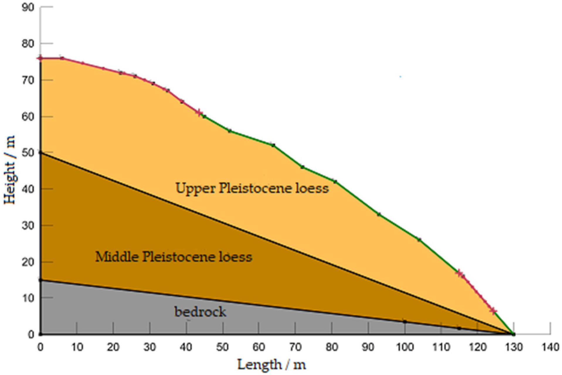
3.3. Landslide Profile Construction and Selection of Computational Conditions

The main vegetation type is Periploca sepium, which has strong adhesion and cohesion of the root system to the vegetation. In this study, the main analyses for the evaluation of the landslide in Ganquan County’s Qiangchigou were applied to two cases with different root densities and different soil moisture contents. Under the condition of a natural soil moisture content (for Periploca sepium, 6.4% after field sampling), we used the natural root density of Periploca sepium (0.5 g/100 g soil) and 1.5 (0.75 g/100 g soil) and 2.0 times that density (1.0 g/100 g soil). The different soil moisture contents were taken as slope conditions with 10, 20 and 30 percent moisture contents at the natural root density.
According to the field survey and relevant geological data, the landslide body is Quaternary Upper Pleistocene chalk. The strata of the landslide are, from top to bottom, Quaternary Upper Pleistocene chalk, Quaternary Upper Pleistocene loess, Quaternary Middle Pleistocene loess and Cretaceous muddy sandstone. The slip zone is the contact zone of Cretaceous sandstone and loess; the slip bed is Cretaceous sandstone. Accordingly, the evaluation model of the landslide was constructed, and the landslide profile was simplified to Quaternary Upper Pleistocene loess, Quaternary Middle Pleistocene loess and Cretaceous sandstone (Figure 2).

3.4. Soil Parameters Under Different Test Conditions

According to the indoor experimental data and the landslide field investigation of stability, we comprehensively determined the landslide parameters for Periploca sepium in different root densities, which are shown in Table 2. Periploca sepium is the main plant species in the study area, and its natural root density is 0.5 g/100 g soil. We set up three root density gradients: the natural root density and 1.5 and 2.0 times that density. Periploca sepium soil shear strength decreased with an increasing root density.
According to the Specification for Landslide Prevention and Control Engineering Investigation (DZ/T0218-2006) [69], a stable state of a landslide and the corresponding safety coefficient are as shown in Table 3 below. The stability of the landslide is evaluated in terms of the stable state corresponding to the value of the safety coefficient simulated by the model.

3.5. Slope Stability Under Different Conditions

We calculated the stability of the landslide in Ganquan County, Chuanchigou under different root density conditions, and the results are shown in Figure 3. The slope stability coefficient under the natural root density condition is 1.263, and the slope is stable in its natural state. The slope stability coefficient under a 1.5 times finer density is 1.118, and the stability coefficient under 2 times the root density decreases to 0.953, which is very unstable. Overall, the root–soil shear strength of Periploca sepium runs in the order of natural root density > 1.5 times root density > 2 times root density, indicating that the area is not suitable for landslide control using Periploca sepium vegetation.
Figure 4 shows the simulation results of the landslide in Ganquan County under different soil moisture content conditions. The trend is that the higher the moisture content, the lower the slope coefficient of the landslide. The landslide is in a stable state under a 10% moisture content, and it is in a very unstable state under a 30% moisture content, with a stability coefficient of 0.659. The above data show that the root density of vegetation and rainfall are important factors for the occurrence of landslides.

4. Discussion

In this study, the slope stability of a typical landslide area in the Loess Plateau under different conditions of vegetation root density and soil moisture content was analyzed through field investigation and numerical simulation based on the GeoStudio model. The results show that the vegetation root density and soil moisture content are important factors affecting the stability of loess landslides.
Rainfall reduces the shear strength of loess slopes by altering the soil water content, while human activities such as engineering excavation and afforestation increase the risk of landslide occurrence by changing the soil structure and increasing the slope load. This is in agreement with previous findings that emphasize the importance of rainfall and human activities in the occurrence of loess landslides [11,70]. Rainfall-induced changes in soil moisture content lead to eolian landslides, while human activities such as afforestation and engineering excavations affect slope stability by altering the soil structure. These activities may increase the instability of slopes, especially in a geologic environment such as loess, which is structurally sparse and has developed vertical joints. This study further investigated the dual role of vegetation on loess landslide stability [71]. On the one hand, the vegetation root system increases the shear strength of the soil body and improves slope stability through physical anchoring [72]. On the other hand, vegetation root systems may promote water infiltration, increase soil deadweight and decrease shear strength, thus increasing the landslide risk. This finding echoes the findings of Guzzetti et al. (2008) that the effect of vegetation cover on landslides is complex and requires a combination of factors such as vegetation type, root density and soil moisture content [73].
The loose porous structure and permeability anisotropy of loess have important effects on landslide stability. This study shows that the high water-holding capacity and high permeability in the vertical direction of loess may lead to a rapid increase in soil deadweight under rainfall conditions, thus increasing the risk of landslides. This finding emphasizes the need to consider the hydromechanical properties of loess soils when conducting landslide stability assessment in loess areas [74]. Although this study provides new insights into the stability of loess landslides, there are some limitations. First, this study mainly focuses on one landslide site, Qiangchigou, Ganquan County, which may not be fully representative of landslide properties in the entire Loess Plateau region. Second, this study mainly focused on the effects of vegetation and soil moisture content on landslide stability without considering other possible factors such as earthquakes and freeze–thaw effects. Future studies could expand the scope of this study to consider more influencing factors and explore landslide control measures under different environmental conditions [75].
In addition, the GeoStudio model used in this study, while providing valuable predictions, may need further validation and improvement when simulating landslide stability under complex geological conditions. Future studies could utilize more field monitoring data to calibrate and validate the predictive accuracy of the model. In conclusion, this study provides a new perspective on the triggering factors and stability assessment of loess landslides through field investigation and numerical simulation. The results of this study are of great practical significance for the development of landslide control measures in the Loess Plateau region and provide a new direction for future research.

5. Conclusions

In this study, a detailed analysis was carried out for the loess landslide site of Qiangchigou, Ganquan County, Yan’an City, Shaanxi Province, aimed at exploring the triggering factors of loess landslides, the stability assessment methods and the influence of vegetation on the stability of landslides. Through field investigations, physico-mechanical experiments and numerical simulations, a number of conclusions and insights were drawn from this study. The findings of the present study echo those of Guzzetti et al. (2008) that the effect of vegetation on landslides is complex and requires a combination of factors such as vegetation type, root density and soil moisture content [73].
The results of this study confirm that rainfall and human activities are the key factors inducing loess landslides. Vegetation root systems have a dual role in loess landslide stability. On the one hand, vegetation increases the shear strength of slopes through physical anchoring; on the other hand, the presence of vegetation may promote water infiltration, increase soil deadweight and decrease shear strength, thereby increasing the landslide risk in some cases.
The high water-holding capacity and anisotropic permeability of loess may lead to a rapid increase in soil deadweight under rainfall conditions, thereby increasing the landslide risk. This finding emphasizes the need to consider the hydromechanical properties of loess soils when conducting landslide stability assessment in loess areas. Through numerical simulation of the GeoStudio model, this study assessed the stability of loess slopes under different plant root densities and soil moisture contents. Simulation results show that under natural conditions, Periploca sepium grows for 7 years with a root density of 0.5 g/100 g, and the slope is in a stable condition under these conditions. As the plant grows, its root density increases and the stability coefficient decreases, contributing to eolian landslides. Landslide stability coefficients decrease with an increasing root density and soil moisture content, suggesting that vegetation may not be conducive to landslide control under certain conditions.
The findings of this study have important practical implications for the development of landslide control measures in the Loess Plateau region. With an understanding of the effects of vegetation and soil moisture content on landslide stability, the landslide risk can be more accurately predicted and appropriate control measures taken, such as vegetation planting, drainage system construction and soil improvement. In summary, this study not only improves our understanding of the factors inducing and influencing the stability of loess landslides but also provides a scientific basis for landslide prevention and control in the Loess Plateau region. Future studies should further explore landslide control measures under different environmental conditions and consider more influencing factors to improve the accuracy of landslide prediction and the effectiveness of control measures. In addition, the methods and findings of this study provide references for landslide studies in similar geological environments and have wide application prospects.

Author Contributions

Conceptualization, L.S.; methodology, L.Y.; software, L.H.; validation, D.H.; formal analysis, B.P.; investigation, L.S. and Z.H.; resources, Z.S.; writing—original draft preparation, L.S. All authors have read and agreed to the published version of the manuscript.

Funding

This work was supported from the projects of the Natural Science Basic Research Plan in Shaanxi Province of China (Program No. 2024JC-YBQN-0329), the Fund for Less Developed Regions of the National Natural Science Foundation of China (No. 42167039), the Key Research and Development Program of Shaanxi (Program Nos. 2022ZDLNY02-01, 2022ZDLNY02-10), the Technology Innovation Center for Land Engineering and Human Settlements, Shaanxi Land Engineering Construction Group Co., Ltd. and Xi’an Jiaotong University (Program Nos. 2021WHZ0090, 2021WHZ0091, 2024WHZ0243) and Shaanxi Provincial Land Engineering Construction Group (Program Nos. DJTD-2023-2, DJNY-YB-2023-8, DJNY2024-35, DJNY2024-36).

Data Availability Statement

The data presented in this study are available on request from the corresponding author.

Conflicts of Interest

Authors Lei Shi, Dongwen Hua and Zenghui Sun were employed by the company Shaanxi Land Engineering Construction Group Co., Ltd. The remaining authors declare that the research was conducted in the absence of any commercial or financial relationships that could be construed as a potential conflict of interest.

References

  1. Nypan, I.M. Geomorphological Study of Unstable Rock Slope Deformation on Stáluvárri, Kåfjorden, Troms. Master’s Thesis, UiT Norges Arktiske Universitet, Tromsø, Norway, 2024. [Google Scholar]
  2. Ringenbach, A. Experimental Quantification of Deadwood Influence on Rockfall Dynamics and Its Incorporation into Regional-Scale Rockfall Models. Ph.D. Thesis, ETH Zurich, Zurich, Switzerland, 2022. [Google Scholar]
  3. Wen, Y.; Gao, P.; Mu, X.; Li, M.; Su, Y.; Wang, H. Experimental Study on Landslides in Terraced Fields in the Chinese Loessial Region under Extreme Rainfall. Water 2021, 13, 270. [Google Scholar] [CrossRef]
  4. Zhang, F.; Wang, G.; Peng, J. Initiation and Mobility of Recurring Loess Flowslides on the Heifangtai Irrigated Terrace in China: Insights from Hydrogeological Conditions and Liquefaction Criteria. Eng. Geol. 2022, 302, 106619. [Google Scholar] [CrossRef]
  5. Xin, P.; Liang, C.; Wu, S.; Liu, Z.; Shi, J.; Wang, T. Kinematic Characteristics and Dynamic Mechanisms of Large-Scale Landslides in a Loess Plateau: A Case Study for the North Bank of the Baoji Stream Segment of the Wei River, China. Bull. Eng. Geol. Environ. 2016, 75, 659–671. [Google Scholar] [CrossRef]
  6. Khan, A.; Gupta, S.; Gupta, S.K. Multi-Hazard Disaster Studies: Monitoring, Detection, Recovery, and Management, Based on Emerging Technologies and Optimal Techniques. Int. J. Disaster Risk Reduct. 2020, 47, 101642. [Google Scholar] [CrossRef]
  7. Basher, R. Global Early Warning Systems for Natural Hazards: Systematic and People-Centred. Philos. Trans. R. Soc. A Math. Phys. Eng. Sci. 2006, 364, 2167–2182. [Google Scholar] [CrossRef]
  8. Garcia, C.; Fearnley, C.J. Evaluating Critical Links in Early Warning Systems for Natural Hazards. Environ. Hazards 2012, 11, 123–137. [Google Scholar] [CrossRef]
  9. Liu, X.; Lan, H.; Li, L.; Cui, P. An Ecological Indicator System for Shallow Landslide Analysis. CATENA 2022, 214, 106211. [Google Scholar] [CrossRef]
  10. Bordoloi, S.; Ng, C.W.W. The Effects of Vegetation Traits and Their Stability Functions in Bio-Engineered Slopes: A Perspective Review. Eng. Geol. 2020, 275, 105742. [Google Scholar] [CrossRef]
  11. Arnone, E.; Caracciolo, D.; Noto, L.V.; Preti, F.; Bras, R.L. Modeling the Hydrological and Mechanical Effect of Roots on Shallow Landslides. Water Resour. Res. 2016, 52, 8590–8612. [Google Scholar] [CrossRef]
  12. Masi, E.B.; Segoni, S.; Tofani, V. Root Reinforcement in Slope Stability Models: A Review. Geosciences 2021, 11, 212. [Google Scholar] [CrossRef]
  13. Lann, T.; Bao, H.; Lan, H.; Zheng, H.; Yan, C.; Peng, J. Hydro-Mechanical Effects of Vegetation on Slope Stability: A Review. Sci. Total Environ. 2024, 926, 171691. [Google Scholar] [CrossRef] [PubMed]
  14. Alaoui, A.; Lipiec, J.; Gerke, H.H. A Review of the Changes in the Soil Pore System Due to Soil Deformation: A Hydrodynamic Perspective. Soil Tillage Res. 2011, 115–116, 1–15. [Google Scholar] [CrossRef]
  15. Stokes, A.; Atger, C.; Bengough, A.G.; Fourcaud, T.; Sidle, R.C. Desirable Plant Root Traits for Protecting Natural and Engineered Slopes against Landslides. Plant Soil 2009, 324, 1–30. [Google Scholar] [CrossRef]
  16. Gue, S.-S. Landslides: How, Why and the Way Forward. IEM J. 2023, 84. [Google Scholar] [CrossRef]
  17. Akinola, A.I. Temporal and Thermal Effects on Fluvial Erosion of Cohesive Streambank Soils. Ph.D. Thesis, Virginia Polytechnic Institute and State University, Blacksburg, VA, USA, 2018. [Google Scholar]
  18. Yerro, A.; Pinyol, N.M.; Alonso, E.E. Internal Progressive Failure in Deep-Seated Landslides. Rock Mech. Rock Eng. 2016, 49, 2317–2332. [Google Scholar] [CrossRef]
  19. Dong, H.; Song, Y.; Chen, T.; Zhao, J.; Yu, L. Geoconservation and Geotourism in Luochuan Loess National Geopark, China. Quat. Int. 2014, 334–335, 40–51. [Google Scholar] [CrossRef]
  20. He, P.; Guo, J.; Zhang, S. Investigation of Stability and Underlying Mechanism of Unstable Subgrades Loess Modified by Carbide Slag in Road Construction Projection. Buildings 2023, 13, 2176. [Google Scholar] [CrossRef]
  21. Guo, Y.; Liu, Y.; Li, R.; Li, Y.; Wang, J. TIC-Driven Sustainable Land Use Mode in the Loess Plateau: A Case Study of Gully Land Consolidation Project in Yan’an City, China. Land Use Policy 2024, 140, 107107. [Google Scholar] [CrossRef]
  22. Naseer, S. A Study of Rainfall Infiltration on Slope Stability Using Sand Piles to Reinforce Slopes. Ph.D. Thesis, Nottingham Trent University, Nottingham, UK, 2023. [Google Scholar]
  23. Wang, H.Y.; Liu, X.J.; Li, J.S.; Liu, C.P.; Jiang, J.Y. Research and Practice of Regional Comprehensive Disaster Prevention and Mitigation Planning: A Case Study in Tanghai County. Appl. Mech. Mater. 2013, 256–259, 2747–2753. [Google Scholar] [CrossRef]
  24. Pearce, L. Disaster Management and Community Planning, and Public Participation: How to Achieve Sustainable Hazard Mitigation. Nat. Hazards 2003, 28, 211–228. [Google Scholar] [CrossRef]
  25. Wang, H.B.; Wu, S.R.; Shi, J.S.; Li, B. Qualitative Hazard and Risk Assessment of Landslides: A Practical Framework for a Case Study in China. Nat. Hazards 2013, 69, 1281–1294. [Google Scholar] [CrossRef]
  26. Zhang, W.; Liu, S.; Wang, L.; Samui, P.; Chwała, M.; He, Y. Landslide Susceptibility Research Combining Qualitative Analysis and Quantitative Evaluation: A Case Study of Yunyang County in Chongqing, China. Forests 2022, 13, 1055. [Google Scholar] [CrossRef]
  27. Acevedo, A.M.G.; de Brum Passini, L.; Talamini, A.A.; Kormann, A.C.M.; Fiori, A.P. Assessing Limit Equilibrium Method Approach and Mapping Critical Areas for Slope Stability Analysis in Serra Do Mar Paranaense—Brazil. Environ. Earth Sci. 2021, 80, 572. [Google Scholar] [CrossRef]
  28. Arai, K.; Tagyo, K. Determination of Noncircular Slip Surface Giving the Minimum Factor of Safety in Slope Stability Analysis. Soils Found. 1985, 25, 43–51. [Google Scholar] [CrossRef]
  29. Xu, Q.; Chen, W.; Zhao, K.; Zhou, X.; Du, P.; Guo, C.; Ju, Y.; Pu, C. Effects of Land-Use Management on Soil Erosion: A Case Study in a Typical Watershed of the Hilly and Gully Region on the Loess Plateau of China. CATENA 2021, 206, 105551. [Google Scholar] [CrossRef]
  30. Li, Z.; Zhang, Y.; Zhu, Q.; He, Y.; Yao, W. Assessment of Bank Gully Development and Vegetation Coverage on the Chinese Loess Plateau. Geomorphology 2015, 228, 462–469. [Google Scholar] [CrossRef]
  31. Zhang, X.; Fu, Y.; Pei, Q.; Guo, J.; Jian, S. Study on the Root Characteristics and Effects on Soil Reinforcement of Slope-Protection Vegetation in the Chinese Loess Plateau. Forests 2024, 15, 464. [Google Scholar] [CrossRef]
  32. Yao, Y.; Zhang, Y.; Gao, X.; Huang, H.; Liu, D.; Hui, X. Study on Permeability and Collapsibility Characteristics of Sandy Loess in Northern Loess Plateau, China. J. Hydrol. 2021, 603, 126883. [Google Scholar] [CrossRef]
  33. Jandyal, T.; Shah, M.Y. Strength Behaviour of Marginal Soil Reinforced with Grass Roots. Transp. Infrastruct. Geotech. 2024, 11, 1799–1827. [Google Scholar] [CrossRef]
  34. Innocenti, A.; Rosi, A.; Tofani, V.; Pazzi, V.; Gargini, E.; Masi, E.B.; Segoni, S.; Bertolo, D.; Paganone, M.; Casagli, N. Geophysical Surveys for Geotechnical Model Reconstruction and Slope Stability Modelling. Remote Sens. 2023, 15, 2159. [Google Scholar] [CrossRef]
  35. Hencher, S.R. Preferential Flow Paths through Soil and Rock and Their Association with Landslides. Hydrol. Process. 2010, 24, 1610–1630. [Google Scholar] [CrossRef]
  36. Sidle, R.C.; Bogaard, T.A. Dynamic Earth System and Ecological Controls of Rainfall-Initiated Landslides. Earth-Sci. Rev. 2016, 159, 275–291. [Google Scholar] [CrossRef]
  37. Qin, M.; Cui, P.; Jiang, Y.; Guo, J.; Zhang, G.; Ramzan, M. Occurrence of Shallow Landslides Triggered by Increased Hydraulic Conductivity Due to Tree Roots. Landslides 2022, 19, 2593–2604. [Google Scholar] [CrossRef]
  38. Yan, G.; Yin, Y.; Huang, B.; Zhang, Z.; Zhu, S. Formation Mechanism and Characteristics of the Jinjiling Landslide in Wushan in the Three Gorges Reservoir Region, China. Landslides 2019, 16, 2087–2101. [Google Scholar] [CrossRef]
  39. Nie, W.; Tian, C.; Song, D.; Liu, X.; Wang, E. Disaster Process and Multisource Information Monitoring and Warning Method for Rainfall-Triggered Landslide: A Case Study in the Southeastern Coastal Area of China. Nat Hazards 2024. [Google Scholar] [CrossRef]
  40. Wei, X.; Yan, D.; Ma, P. Study on the Characteristics and Geomorphologic Evolution Patterns of Loess Landslides on the Heifangtai Terrace, China. Preprints 2023. [Google Scholar] [CrossRef]
  41. Zhang, X.; Song, J.; Wang, Y.; Sun, H.; Li, Q. Threshold Effects of Vegetation Coverage on Runoff and Soil Loss in the Loess Plateau of China: A Meta-Analysis. Geoderma 2022, 412, 115720. [Google Scholar] [CrossRef]
  42. He, J.; Shi, X.; Fu, Y. Identifying Vegetation Restoration Effectiveness and Driving Factors on Different Micro-Topographic Types of Hilly Loess Plateau: From the Perspective of Ecological Resilience. J. Environ. Manag. 2021, 289, 112562. [Google Scholar] [CrossRef]
  43. Gu, C.; Mu, X.; Gao, P.; Zhao, G.; Sun, W.; Tan, X. Distinguishing the Effects of Vegetation Restoration on Runoff and Sediment Generation on Simulated Rainfall on the Hillslopes of the Loess Plateau of China. Plant Soil 2020, 447, 393–412. [Google Scholar] [CrossRef]
  44. Mickovski, S.B.; Stokes, A.; van Beek, R.; Ghestem, M.; Fourcaud, T. Simulation of Direct Shear Tests on Rooted and Non-Rooted Soil Using Finite Element Analysis. Ecol. Eng. 2011, 37, 1523–1532. [Google Scholar] [CrossRef]
  45. Comino, E.; Druetta, A. The Effect of Poaceae Roots on the Shear Strength of Soils in the Italian Alpine Environment. Soil Tillage Res. 2010, 106, 194–201. [Google Scholar] [CrossRef]
  46. Wei, T.; Fan, W.; Yuan, W.; Wei, Y.; Yu, B. Three-Dimensional Pore Network Characterization of Loess and Paleosol Stratigraphy from South Jingyang Plateau, China. Environ. Earth Sci. 2019, 78, 333. [Google Scholar] [CrossRef]
  47. Hou, K.; Qian, H.; Zhang, Y.; Zhang, Q.; Qu, W. New Insights into Loess Formation on the Southern Margin of the Chinese Loess Plateau. CATENA 2021, 204, 105444. [Google Scholar] [CrossRef]
  48. Nsenga Kumwimba, M.; Zhu, B.; Stefanakis, A.I.; Ajibade, F.O.; Dzakpasu, M.; Soana, E.; Wang, T.; Arif, M.; Kavidia Muyembe, D.; Agboola, T.D. Advances in Ecotechnological Methods for Diffuse Nutrient Pollution Control: Wicked Issues in Agricultural and Urban Watersheds. Front. Environ. Sci. 2023, 11, 1199923. [Google Scholar] [CrossRef]
  49. Gaur, N.; Mohanty, B.P. Land-Surface Controls on near-Surface Soil Moisture Dynamics: Traversing Remote Sensing Footprints. Water Resour. Res. 2016, 52, 6365–6385. [Google Scholar] [CrossRef]
  50. Lan, H.; Zhang, T.; Peng, J.; Zhang, F.; Li, L.; Wu, Y.; Tian, N.; Clague, J.J. Large Scale Land Reclamation and the Effects on Hydro-Mechanical Behavior in Loess and Loess-Derived Fill. Eng. Geol. 2023, 323, 107241. [Google Scholar] [CrossRef]
  51. Chen, Y.; Wei, T.; Ren, K.; Sha, G.; Guo, X.; Fu, Y.; Yu, H. The Coupling Interaction of Soil Organic Carbon Stock and Water Storage after Vegetation Restoration on the Loess Plateau, China. J. Environ. Manag. 2022, 306, 114481. [Google Scholar] [CrossRef]
  52. Jianzhong, S. Environmental Geology in Loess Areas of China. Environ. Geol. Water Sci 1988, 12, 49–61. [Google Scholar] [CrossRef]
  53. Jin-xing, Z.; Chun-yun, Z.; Jing-ming, Z.; Xiao-hui, W.; Zhou-hong, L. Landslide Disaster in the Loess Area of China. J. For. Res. 2002, 13, 157–161. [Google Scholar] [CrossRef]
  54. Yurui, L.; Yi, L.; Pengcan, F.; Hualou, L. Impacts of Land Consolidation on Rural Human–Environment System in Typical Watershed of the Loess Plateau and Implications for Rural Development Policy. Land Use Policy 2019, 86, 339–350. [Google Scholar] [CrossRef]
  55. Badamfirooz, J.; Sarkheil, H.; Mousazadeh, R.; Ayatollahi, F. A Proposed Framework for Estimating the Environmental Damage Cost of Mining Activities in Line with the Goals of Sustainable Mining: A Case Study of Sungun-Ahar Copper Mine, Iran. Int. J. Min. Geo-Eng. 2022, 56, 167–180. [Google Scholar] [CrossRef]
  56. Nan, G.; Han, L.; Wang, Y. Assessing Vulnerability of Coupled Human–Environment Systems and Its Influence Factors in Yan’an City, China. Hum. Ecol. Risk Assess. Int. J. 2022, 28, 783–801. [Google Scholar] [CrossRef]
  57. Li, B.; Han, L.; Li, L. Construction of Ecological Security Pattern in Combination with Landslide Sensitivity: A Case Study of Yan’an City, China. J. Environ. Manag. 2024, 366, 121765. [Google Scholar] [CrossRef] [PubMed]
  58. Gong, Q.; Wang, J.; Zhou, P.; Guo, M. A Regional Landslide Stability Analysis Method under the Combined Impact of Rainfall and Vegetation Roots in South China. Adv. Civ. Eng. 2021, 2021, 5512281. [Google Scholar] [CrossRef]
  59. Pei, T.; Ji, Z.; Chen, Y.; Wu, H.; Hou, Q.; Qin, G.; Xie, B. The Sensitivity of Vegetation Phenology to Extreme Climate Indices in the Loess Plateau, China. Sustainability 2021, 13, 7623. [Google Scholar] [CrossRef]
  60. Brooker, R.W.; Maestre, F.T.; Callaway, R.M.; Lortie, C.L.; Cavieres, L.A.; Kunstler, G.; Liancourt, P.; Tielbörger, K.; Travis, J.M.J.; Anthelme, F.; et al. Facilitation in Plant Communities: The Past, the Present, and the Future. J. Ecol. 2008, 96, 18–34. [Google Scholar] [CrossRef]
  61. Yao, Y.; Shao, M.; Fu, X.; Wang, X.; Wei, X. Effects of Shrubs on Soil Nutrients and Enzymatic Activities over a 0–100 cm Soil Profile in the Desert-Loess Transition Zone. CATENA 2019, 174, 362–370. [Google Scholar] [CrossRef]
  62. Huang, H.; Reddy, N.G.; Huang, X.; Chen, P.; Wang, P.; Zhang, Y.; Huang, Y.; Lin, P.; Garg, A. Effects of Pyrolysis Temperature, Feedstock Type and Compaction on Water Retention of Biochar Amended Soil. Sci. Rep. 2021, 11, 7419. [Google Scholar] [CrossRef]
  63. Zhang, J.; Niu, G.; Li, X.; Sun, D. Hydro-Mechanical Behavior of Expansive Soils with Different Dry Densities over a Wide Suction Range. Acta Geotech. 2020, 15, 265–278. [Google Scholar] [CrossRef]
  64. Zhu, R.; Xie, W.; Liu, Q.; Yang, H.; Wang, Q. Shear Behavior of Sliding Zone Soil of Loess Landslides via Ring Shear Tests in the South Jingyang Plateau. Bull. Eng. Geol. Environ. 2022, 81, 244. [Google Scholar] [CrossRef]
  65. Li, J.; Li, J.; Zhang, J.; Liu, G. Static and Dynamic Properties Study on Interface between New Polymer Materials and Silty Clay Based on Ring Shear Tests. Polymers 2023, 15, 634. [Google Scholar] [CrossRef] [PubMed]
  66. Jiang, H.; Zou, Q.; Jiang, Y.; Zhou, B.; Yao, H.; Cui, J.; Zhou, W.; Chen, S. Development of an Integrated Model for Assessing Landslide Susceptibility on Vegetated Slopes under Random Rainfall Scenarios. Ecol. Eng. 2024, 199, 107150. [Google Scholar] [CrossRef]
  67. Hassan, W.; Alshameri, B.; Nawaz, M.N.; Qamar, S.U. Experimental Study on Shear Strength Behavior and Numerical Study on Geosynthetic-Reinforced Cohesive Soil Slope. Innov. Infrastruct. Solut. 2022, 7, 349. [Google Scholar] [CrossRef]
  68. Chen, M.; Zhou, J.; Yang, X. A Novel Approach for Slope Stability Evaluation Considering Landslide Dynamics and Its Application to Reservoir Landslide. Nat. Hazards 2024, 120, 3589–3621. [Google Scholar] [CrossRef]
  69. Xu, J.; Sun, C. Geological Evaluation of Landslide Engineering in Southern Mountainous Areas of Henan Province. E3S Web Conf. 2024, 554, 01011. [Google Scholar] [CrossRef]
  70. Bodner, G.; Mentler, A.; Keiblinger, K. Plant Roots for Sustainable Soil Structure Management in Cropping Systems. In The Root Systems in Sustainable Agricultural Intensification; John Wiley & Sons: Hoboken, NJ, USA, 2021; pp. 45–90. ISBN 978-1-119-52541-7. [Google Scholar]
  71. Wang, J.; Li, P.; Ma, Y.; Li, T. Influence of Irrigation Method on the Infiltration in Loess: Field Study in the Loess Plateau. Desalination Water Treat. 2018, 110, 298–307. [Google Scholar] [CrossRef]
  72. Tang, Y.M.; Xue, Q.; Li, Z.G.; Feng, W. Three Modes of Rainfall Infiltration Inducing Loess Landslide. Nat. Hazards 2015, 79, 137–150. [Google Scholar] [CrossRef]
  73. Guzzetti, F.; Peruccacci, S.; Rossi, M.; Stark, C.P. The Rainfall Intensity–Duration Control of Shallow Landslides and Debris Flows: An Update. Landslides 2008, 5, 3–17. [Google Scholar] [CrossRef]
  74. Li, Z.; Ma, P.; Zhuang, J.; Mu, Q.; Kong, J.; Zhao, L.; Peng, J. Permeability Characteristics, Structural Failure Characteristics, and Triggering Process of Loess Landslides in Two Typical Strata Structures. Eng. Geol. 2024, 341, 107728. [Google Scholar] [CrossRef]
  75. Tang, Y.; Feng, F.; Guo, Z.; Feng, W.; Li, Z.; Wang, J.; Sun, Q.; Ma, H.; Li, Y. Integrating Principal Component Analysis with Statistically-Based Models for Analysis of Causal Factors and Landslide Susceptibility Mapping: A Comparative Study from the Loess Plateau Area in Shanxi (China). J. Clean. Prod. 2020, 277, 124159. [Google Scholar] [CrossRef]
Figure 1. Landslide point distribution map in Ganquan County.
Water 16 03558 g001
Figure 2. Study of the original topographic profile of the slope (the red line in the upper part of the slope indicates the entrance to the slip surface, the red line in the lower part of the slope indicates the exit from the slip surface, and the green line indicates that the slope has no slip).
Water 16 03558 g002
Figure 3. Simulation results of slope stability under different root density conditions.
Water 16 03558 g003
Figure 4. Simulation results of slope stability under different soil moisture content conditions.
Water 16 03558 g004
Table 1. Parameter selection for different conditions.
Plant TypeNatural Water Content (%)Saturated Water Content (%)Natural Density (g/cm3)Saturation Density (g/cm3)Dry Density (g/cm3)Porosity RatioSoil Coefficient of Permeability
(Kfs, mm/min)
I14.2232.951.441.851.241.090.74
II16.8232.561.431.821.231.150.52
III14.8426.171.491.831.31.020.98
IV13.6523.081.832.081.610.71.45
Table 2. Soil parameters under different test conditions.
Working ConditionLithologyBulk Density (KN/m3)Cohesion (kpa)Angle of Internal Friction (°)
Different root densitiesNatural root density14.029.1328.37
1.5 times that root density14.025.4325.64
2.0 times that root density14.023.1321.80
Different soil moisture contents10%13.922.4627.02
20%14.11.5122.78
30%14.54.3520.30
Table 3. Landslide stability rating scale.
Steady StateVery UnstableUnstableStabilizedStable
Stabilization factorFs < 1.001 ≤ Fs < 1.051.05 ≤ Fs < 1.15Fs ≥ 1.15
Disclaimer/Publisher’s Note: The statements, opinions and data contained in all publications are solely those of the individual author(s) and contributor(s) and not of MDPI and/or the editor(s). MDPI and/or the editor(s) disclaim responsibility for any injury to people or property resulting from any ideas, methods, instructions or products referred to in the content.

