Article

Modeling and Application of the Hydrus-2D Model for Simulating Preferential Flow in Loess Soil Under Various Scenarios

1
School of Water and Environment, Chang’an University, 126 Yanta Road, Xi’an 710054, China
2
Key Laboratory of Subsurface Hydrology and Ecological Effect in Arid Region of the Ministry of Education, Chang’an University, Xi’an 710054, China
3
Key Laboratory of Eco-hydrology and Water Security in Arid and Semi-arid Regions of Ministry of Water Resources Chang’an University, Chang’an University, Xi’an 710054, China
4
Shaanxi Geological Environment Monitoring Station, Xi’an 710054, China
5
Key Laboratory of Mine Geological Hazards Mechanism and Control, Ministry of Natural Resources, Xi’an 710054, China
*
Author to whom correspondence should be addressed.
Water 2024, 16(24), 3653; https://doi.org/10.3390/w16243653
Submission received: 6 November 2024 / Revised: 12 December 2024 / Accepted: 17 December 2024 / Published: 18 December 2024
(This article belongs to the Special Issue Advance in Groundwater in Arid Areas)

Abstract

:
Soil hydraulic properties are mainly governed by the soil’s heterogeneity, anisotropy, and discontinuous structural characteristics, primarily when connected soil macropores characterize the structures. Therefore, researchers must document reliable hydrological models to elucidate how the soil medium affects the movement of soil water. This study, utilizing a field-scale staining tracer test, distinguishes between matrix flow and preferential flow areas in the seepage field of Xi’an loess. The Xi’an loess’s soil water characteristic curve (SWCC) was explored through field investigations and laboratory analyses. A dual-permeability model that couples matrix and macropore flow was developed using the Hydrus-2D model, enabling simulations of water migration under varying initial soil water content, rainfall intensity, and crack width. The results showed that (1) The SWCC of macropores in the preferential flow area exhibits a bimodal distribution, and the Fredlund & Xing model is applied for sectional fitting to obtain the corresponding soil water characteristic parameters. (2) Initial soil water content and rainfall intensity significantly influence water distribution, while crack width has a relatively minor effect. (3) The cumulative flux under the preferential flow is significantly higher than in the matrix area, and the wetting front depth increases with higher initial water content and rainfall intensity. This study reveals the key characteristics of preferential flow and moisture migration in the matrix zone and their influencing factors in loess. It constructs a two-domain infiltration model by integrating loess’s diverse structural characteristics and pore morphology. This model provides a theoretical basis and technical support for simulating preferential flow and studying the moisture dynamics of loess profiles.

1. Introduction

Loess is an aeolian deposit formed under arid and semi-arid climatic conditions. It is mainly distributed in the desert zone of middle latitudes in China, constituting the main body of the Loess Plateau in China, with a distribution area of 630,000 km2 [1,2,3]. Due to soil evaporation and limited rainfall, the loess region experiences relatively dry conditions and sparse vegetation, leading to gradual desertification of the landscape [4,5,6]. Within this environment, loess contains preferential flow pore structures, including root pores, wormholes, and fissures. These structures are crucial in enabling the rapid groundwater response after rainfall events [7,8,9]. The movement and distribution of soil moisture along these preferential channels are essential. They can significantly alleviate the challenges of drought and semi-arid conditions on the Loess Plateau [10,11,12]. Therefore, studying the loess’s preferential flow seepage processes is essential for understanding the dynamic changes in soil moisture and seepage mechanisms. This research also provides critical support for effective water resource management.
In the soil of the Loess Plateau, the effect of heterogeneity on water flow is particularly significant [13,14,15]. The soil parent material of the Loess Plateau is mainly composed of silt and sand, which are subject to wind action and are easily transported and accumulated, thus showing strong consistency and homogeneity in certain areas [16,17,18]. However, with the formation of accumulated loess, the soil has gradually evolved into a complex heterogeneous structure under the action of plant roots [9,19,20], animal burrows [21,22], and soil cement [23,24,25], which is characterized by the coexistence of micropores and macropores [26]. This heterogeneity causes the water migration process in the soil to exhibit complex dynamic characteristics [27,28,29]. Water penetrates slowly through the micropores. However, it can bypass soil particles and rapidly infiltrate deeper layers through well-developed macropores [30,31,32]. Although studies have focused on preferential flow phenomena in the Loess Plateau region, significant progress has been made in loess development, topological structure description, and modeling of macropore pipelines [9,33]. However, there is still a lack of in-depth discussion on water flow characteristics in different heterogeneous soil environments. This is particularly true for understanding the dynamics of the seepage process. In the Loess Plateau, which has a high degree of soil heterogeneity, the non-homogeneity of the soil has a particularly significant effect on water migration. Micropores and macropores coexist in the soil, and water migrates slowly along the micropores and infiltrates rapidly through the macropores. This complex water flow pattern makes the seepage process show mixed flow characteristics, covering piston and preferential flow in the unsaturated state [34]. Water transport processes and their drivers (such as initial water content, rainfall intensity, and cracks width) in loess are still understudied, especially under the unique topographic and climatic conditions of the Loess Plateau of China. Human activities, such as long-term overgrazing and agricultural development, have further exacerbated the fragility of the ecological environment in this region. Thus, it is particularly urgent to study the infiltration characteristics of soil moisture in the Loess Plateau region and its relationship with environmental factors. This contributes to an in-depth understanding of the mechanisms of soil erosion and provides a scientific basis for ecological restoration and reconstruction in the region.
To simulate water migration in heterogeneous media, the dual-permeability model (matrix and macropore domains) has received extensive attention recently [35,36,37]. Hydrus-2D/3D 2.05 software has become a preferred tool for studying preferential flow simulation because of its scientific applicability. Since the 1990s, the software has been built with a preferential flow module, which can accurately simulate complex two-domain water movement processes, including the coupling of matrix flow and macropore flow [38,39]. Its user-friendly Windows interface simplifies tasks such as handling boundary conditions, data input, computation, and post-processing. Additionally, it supports the simulation of various complex scenarios. These capabilities have been widely applied in agricultural irrigation, water infiltration, and solute transport [40,41,42,43,44]. Hydrus-2D/3D has unique preferential flow simulation advantages compared to other commonly used hydrological models. The SWAT model mainly simulates long-term hydrological processes at the watershed scale, emphasizing processes such as surface runoff and soil erosion [45]. At the same time, the MIKE SHE is mainly based on integrated watershed simulation, covering multi-scale coupling of surface water, groundwater, and hydrometeorology [46]. However, these two models have limited adaptability and fine processing ability for preferential flow in complex porous media. At the same time, Hydrus-2D/3D has excellent adaptability and accuracy due to its built-in dual-domain seepage function, especially in complex porous media [47]. Given the preferential flow characteristics in loess, future research needs to combine experimental validation with simulation analysis further. This will help investigate the seepage characteristics of loess under different scenarios. Such research will provide a more reliable basis for water resource management and the optimization of agricultural irrigation.
The soil water transport process and its driving factors (such as initial water content, rainfall intensity, and cracks width) have not been thoroughly studied under arid and semi-arid conditions with varying rainfall. To fill this research gap, this study focused on Xi’an loess in the Loess Plateau of China. The preferential flow characteristics in the loess profile were systematically simulated through field staining tracer experiments and hydraulic parameters, such as the SWCC, combined with the Hydrus-2D/3D model. The study employed a dual-permeability model with matrix-macropore coupling to simulate the water transport under different initial water contents, rainfall intensity, and crack width. It explored the effects of these factors on the preferential flow. This study contributes to an in-depth understanding of the complexity of water movement and the relationship between soil heterogeneity in loess regions. It also provides technical support and a theoretical basis for water resource management, regional water cycle research, and ecological restoration.

2. Materials and Methods

2.1. Description of the Study Site

The field study was conducted in Liujiapo Village, Lantian County, Xi’an City, Shaanxi Province, China (coordinates: 34°14′19″ N, 109°7′31″ E). The town is located in the hilly area of the Lantian Mountain Range, with undulating terrain at approximately 800 m above sea level. It consists mainly of hills, gullies, and some flat areas. The test site of this study was selected near the abandoned land of the loess plateau, with flat terrain, a surface covered with weeds, and pine saplings distributed on the west side. The topography of the Baolu tableland area, where the test site is located, is flat and favorable for water infiltration. The groundwater type is loess fissure and pore submergence, and the burial depth usually exceeds 50 m. It is mainly discharged to the neighboring Ba River and Chan River basins. Groundwater recharge in the Baolu tableland comes primarily from atmospheric precipitation and irrigation water. In addition, springs are exposed in the surrounding area, with flow rates varying significantly under the influence of rainfall, although the maximum flow rate does not exceed 0.5 L/s. The climate of the study area is characterized as a typical warm temperate semi-humid continental monsoon climate with four distinct seasons. The average annual temperature is 13.1 °C, the annual precipitation is 833.3 mm, the precipitation is concentrated from July to September, and the precipitation in winter is less. In summer, the temperature is high and rainy, often exceeding 30 °C, and in winter, the lowest temperature can drop to −10 °C. Due to its location in the mountainous area, climate change is more significant, and it is susceptible to the influence of the monsoon climate, which has formed a unique ecological environment.

2.2. Dyeing Experiment

This study established four plot groups in Liujiapo Village, Lantian County, Xi’an City. Each group contained five vertical sections. The objective was to investigate the development of preferential flow in Holocene loess and Malan loess structures under varying precipitation conditions. To ensure controlled conditions, no rainfall occurred three days before or after the field test, and the weather remained sunny throughout. Before the test, surface vegetation was carefully trimmed with scissors. A 30 cm layer of top loess was removed, and the surface was meticulously leveled to minimize disturbance and preserve the original loess structure. The testing procedure involved several steps: excavation of test pits, preparation of the dye solution, applying the tracer solution, covering the test area with a film, profile excavation, and sampling for the soil water characteristic curve (SWCC) analysis (see Figure 1). Four test pits were excavated at the sample site, designed similarly to a double-ring test setup. The outer ring of each test pit measured 1.2 m × 1.2 m, while the inner ring measured 0.6 m × 0.6 m (RS1 to RS4). The distance between adjacent test pits was no less than 5 m. Then, the pre-prepared potassium iodide at a concentration of 20 g/L was added to the inner ring of the test pits with the dye tracer solution at different rainfall rates of 0.5, 1, 1.5, and 2 cm/h. Simultaneously, water was added to the outer ring at the same height to maintain consistent conditions. After complete infiltration of the solution, the test area was covered with a film to prevent moisture gain from precipitation and moisture loss through surface evaporation. After 24 h, the film was removed, and soil staining was analyzed. A vertical section measuring 60 cm × 60 cm was excavated, and the stained section was photographed using a Canon 500D digital camera with a resolution of 13 megapixels (Canon (China) Co., Ltd., Beijing, China). The images were processed and quantified using Adobe Photoshop CS6, IPWIN 6, and Origin 2019b. Detailed field sampling methods and the formulas for evaluating preferential flow metrics were described by Kan et al. [48].

2.3. Model Establishment

2.3.1. Mathematical Equations

Macropore cracks and intergranular micropores constitute the dual pore medium of soil (two domains). During the seepage process, the permeability coefficient and seepage velocity of the medium system are different, thus forming two different seepage fields. The water in the macropore cracks medium flows as preferential flow, whereas the water in the intergranular microporous medium moves as matrix flow. The simulation of seepage motion is suitable for the two-domain permeability model. The two domains of this model can be expressed by the Darcy-Richards equation [49] and water and solute exchange between them [50]. Within this framework, the subscripts m and f denote the matrix and macropore domains, respectively. Water movement is described by the following equation, with subscripts m and f explicitly defining the matrix and macropore domains:
θ f t = 1 r r r K f h f h f r + z K f h f h f z + K f h f Γ w f w ,
θ m t = 1 r r r K m h m h m r + z K m h m h m z + K m h m + Γ w 1 f w ,
where hf, hm are the water potentials of the macropore fracture domain and matrix domain, respectively [ML−1T−2]; fw is the ratio of volume of the macropore fracture domain to that of the matrix domain (dimensionless); Kf, Km are the unsaturated permeability coefficients of the macropore fracture domain and matrix domain, respectively [LT−1]; and Γw is the water exchange term between the two domains [T−1].
The solution of the above equation requires two sets of parameters. One is the water-soil characteristic curve, and the other is the corresponding hydraulic conductivity coefficient. These parameters are needed for both the macropore fracture and matrix domains. The calculation formula of the water exchange term Γw between the two domains is as follows:
Γ w = β a 2 γ w K a h a h f h m ,
K a h a = K s a K r m h a
where: Ka is the effective permeability coefficient of water exchange between two domains [LT−1]; Ksa is the saturated permeability coefficient of water exchange between the two domains; Krm(ha) is the relative unsaturated permeability coefficient of matrix domain, which van Genuchten model can obtain; ha is the two-domain interfacial pressure potential, and β is the shape parameter of particles; a is the characteristic length of the particle [L−1]; γw is a scale factor.

2.3.2. Establishment of Hydrus-2D/3D Model

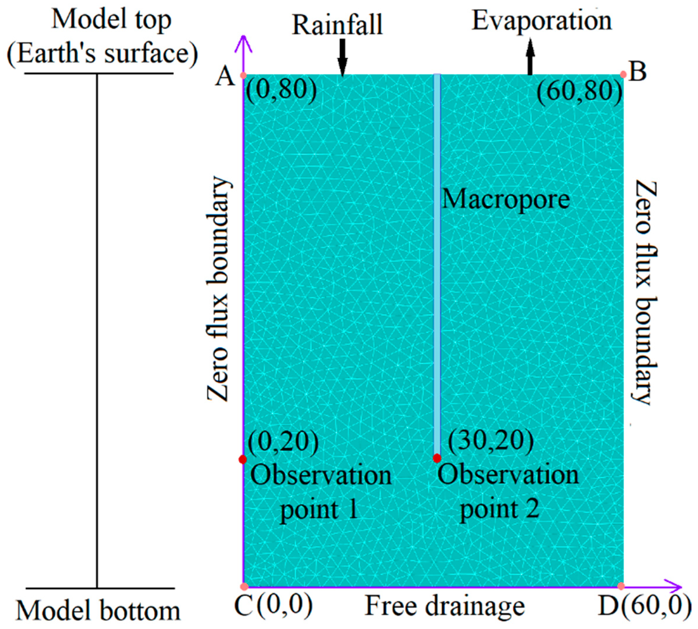
A two-dimensional hydrogeological conceptual model was developed based on previous field investigations and test results of the loess profile in Bailu Plateau, Xi’an. This model generalizes the loess profile, which is illustrated in Figure 2. The study section is 60 cm in length and 80 cm in height. An ample pore space with a height of 50 cm is in the middle of the model. Except for the macropore area, the study domain is a matrix area, which is a homogeneous loess, and the nature of the loess is determined by experiments. In addition, observation points were set up at coordinates (0, 20) and (30, 20), respectively. These points were used to output simulated soil moisture content and water flux data under different scenarios. The data were then compared and analyzed to evaluate the effect of preferential channels on the water infiltration process.

2.4. Determining Conditions of Soil Macropore Flow Movement

2.4.1. Modelled Hydraulic Parameters

Following the approach of Wei et al. [51], the total whole area is referred to as the preferential flow area, while the unstained area is designated as the matrix flow area. This study used a ring knife with a volume of 200 cm3 (inner diameter: 70 mm; height: 53 mm) to collect samples. Three groups of samples were collected from two distinct areas: the preferential flow area (stained area, macropores) and the matrix flow area (unstained area, micropores). A total of 6 sample groups were collected, as depicted in Figure 1f, which were subsequently used to determine the matric suction of loess through the SWCC experiment. The Fredlund & Xing equation [52] was selected to nonlinearly fit the single peak measured data in the Malan loess matrix area. The fitting process was performed using Origin 2018 software based on the least squares principle. The results are shown in Table 1. The bimodal measured data from the Malan loess preferential flow area were divided into two segments. The first segment is the low suction curve, ranging from 10⁻1 to ψd. The second segment is the high suction curve, ranging from ψd to 10⁵. The boundary between macropores and micropores delineates these segments. The Fredlund & Xing model was utilized to fit this section, as presented in Table 2. The model comprises two regions: the matrix region and the macropore region. The hydraulic parameters of the matrix region were derived from the SWCC and infiltration test results. The Hydrus-2D/3D model typically characterizes the macropore area by assigning specific parameters. In this characterization, the residual water content is set to approximately 0 cm3/cm3, while the saturated water content is set to approximately 1 cm3/cm3. In contrast, the saturated hydraulic conductivity is significantly better than the matrix area’s. This simulation employs this method to define the macropore area.

2.4.2. Boundary Conditions

As illustrated in Figure 2, the upper boundary of the model represents the surface, which is in direct contact with the atmosphere and subject to precipitation. Therefore, it is designated as the atmospheric boundary for accumulated water. The lower boundary is situated 80 cm below the surface. It is sufficiently distant from the groundwater level to remain unaffected. Therefore, it is classified as a free drainage boundary. Both side boundaries do not allow water exchange with the external environment and are defined as zero flux boundaries. The characteristics of each boundary are outlined as follows:
K h z K P m ( A B ) h z , t z = 0 ( C D ) h x , t x = 0 ( A C , B D ) ,
where: K denotes unsaturated hydraulic conductivity, cm/h; Pm denotes net infiltration rate at the current moment, cm/h; z denotes the vertical coordinate axis, cm; x denotes the horizontal coordinate axis, cm; h denotes pressure head, cm; and t denotes time, h.

2.4.3. Time Discretization

The numerical simulation covers 48 h of rainfall infiltration during the first 12 h. Different rainfall intensities are set to investigate the preferential inflow infiltration process and its influencing factors. The simulation employs a minimum time step of 0.1 h and a maximum time step of 1 h. For spatial discretization, a triangular mesh is used to compute and subdivide the model domain automatically. Finer meshing is applied at the boundaries and around the macropores. The model area is divided into 12,000 triangular elements (Figure 2).

2.5. Simulation Scenario Setting

Three key variables were selected to evaluate the factors influencing the preferential flow infiltration process in macropores: initial soil water content, rainfall intensity, and crack width. A coupled matrix and macropore domain model was employed to simulate water infiltration under multiple scenarios. Based on measured soil water content, initial soil water content (q0) was set at four levels—0.1, 0.15, 0.2, and 0.3 cm3/cm3. Rainfall intensities (P) of 0.5, 1.0, 1.5, and 2.0 cm/h were chosen. These intensities reflect cumulative rainfall amounts of 6, 12, 18, and 24 cm over 12 h. The values were derived from long-term rainfall data from the study area. Crack widths (L) were established at 0.5, 1.0, 1.5, and 2.0 cm, as indicated by the results of the loess microstructure scanning. The numerical simulation included 12 scenario combinations, with each simulation isolating one variable while keeping others constant. Table 3 provides detailed results for each scenario configuration.

3. Results

3.1. Response of Soil Water Content Variations to Different Scenarios

3.1.1. Different Initial Soil Water Content

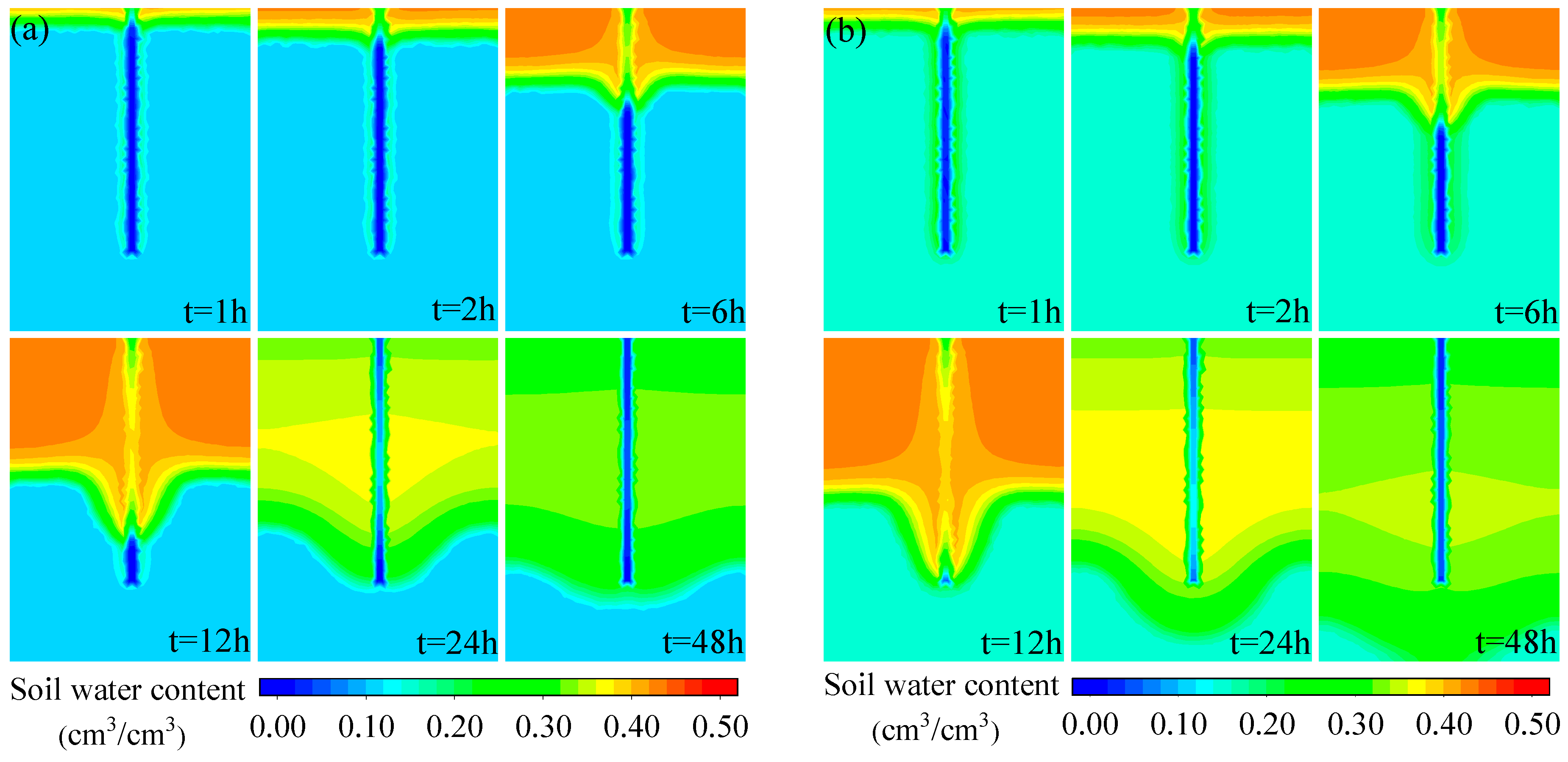
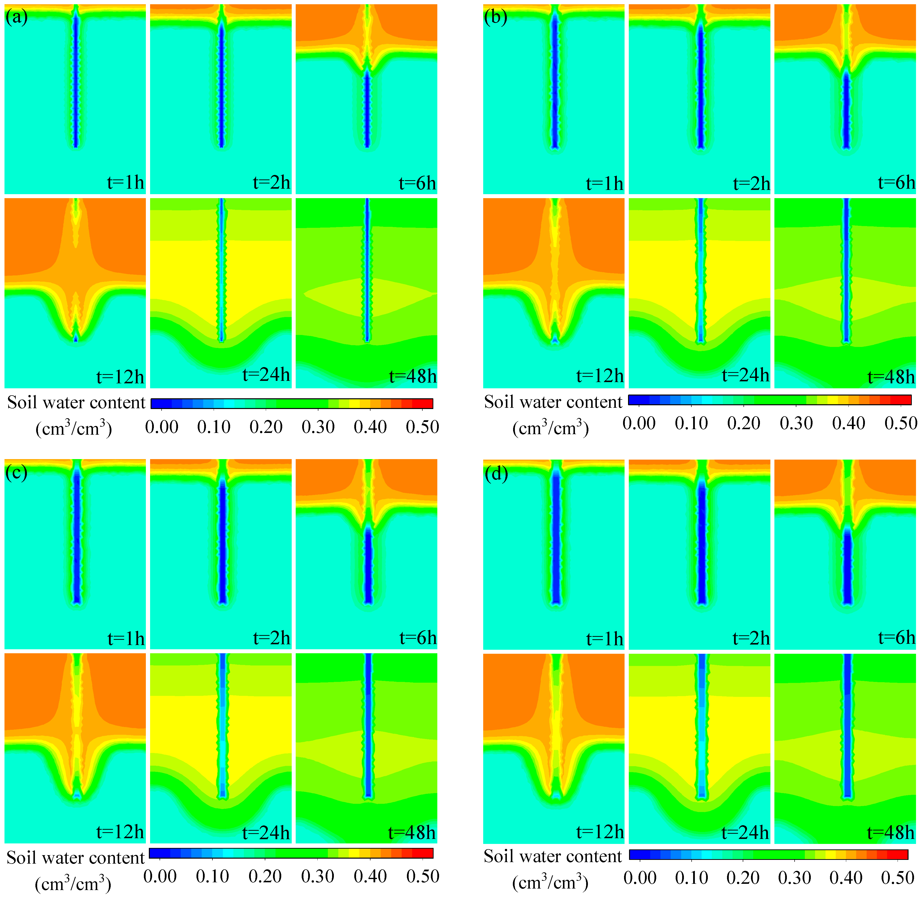
To examine the effect of different initial soil water contents on the preferential flow process in macropores, scenarios with initial water contents of 0.1 cm3/cm3, 0.15 cm3/cm3, 0.2 cm3/cm3, and 0.3 cm3/cm3 were considered. The rainfall intensity was set to P = 1 cm/h, and the crack width was set to L = 1 cm. Typical time intervals of 1 h, 2 h, 6 h, 12 h, 24 h, and 48 h were analyzed to observe the preferential flow process during the study period. The results are shown in Figure 3a–d.
A comparison of the results in Figure 3a–d indicates that initial soil water content variations significantly affect soil moisture’s spatial and temporal distribution during the simulation period. Two distinct features emerge in the initial soil water content profiles across different scenarios. Firstly, large pore channels facilitate clear preferential flow during moisture infiltration. For instance, in Scenario A1, the average infiltration depth in the substrate zone reached 3, 6, 16, and 34 cm in the first, second, sixth, and twelfth hours, respectively. In contrast, the maximum depth of the wetting front transport influence by macropores channels was 7, 11, 27, and 53 cm at the corresponding time intervals. This observation confirms the existence of a preferential flow process within the simulation. Secondly, the depth of the soil wetting front progressively increased with higher initial soil water content. For example, at the twelfth hour, the depths attained by the wetting front in the four scenarios were 53, 63, 72, and greater than 80 cm, demonstrating a significant upward trend. This phenomenon can be attributed to the fact that, as the initial soil water content increases, the precipitation migration within the soil accelerates, leading to greater depths of the wetting front. Additionally, variations in initial water content resulted in differing water distribution patterns in the profiles following the cessation of rainfall. For instance, comparisons between scenarios A1 and A4 at 24 and 48 h reveal a gradual decrease in simulated profile water content. This suggests that soil moisture slowly reverts to its pre-infiltration state post-rainfall, progressively approaching the predetermined initial water content.

3.1.2. Different Rainfall Intensity

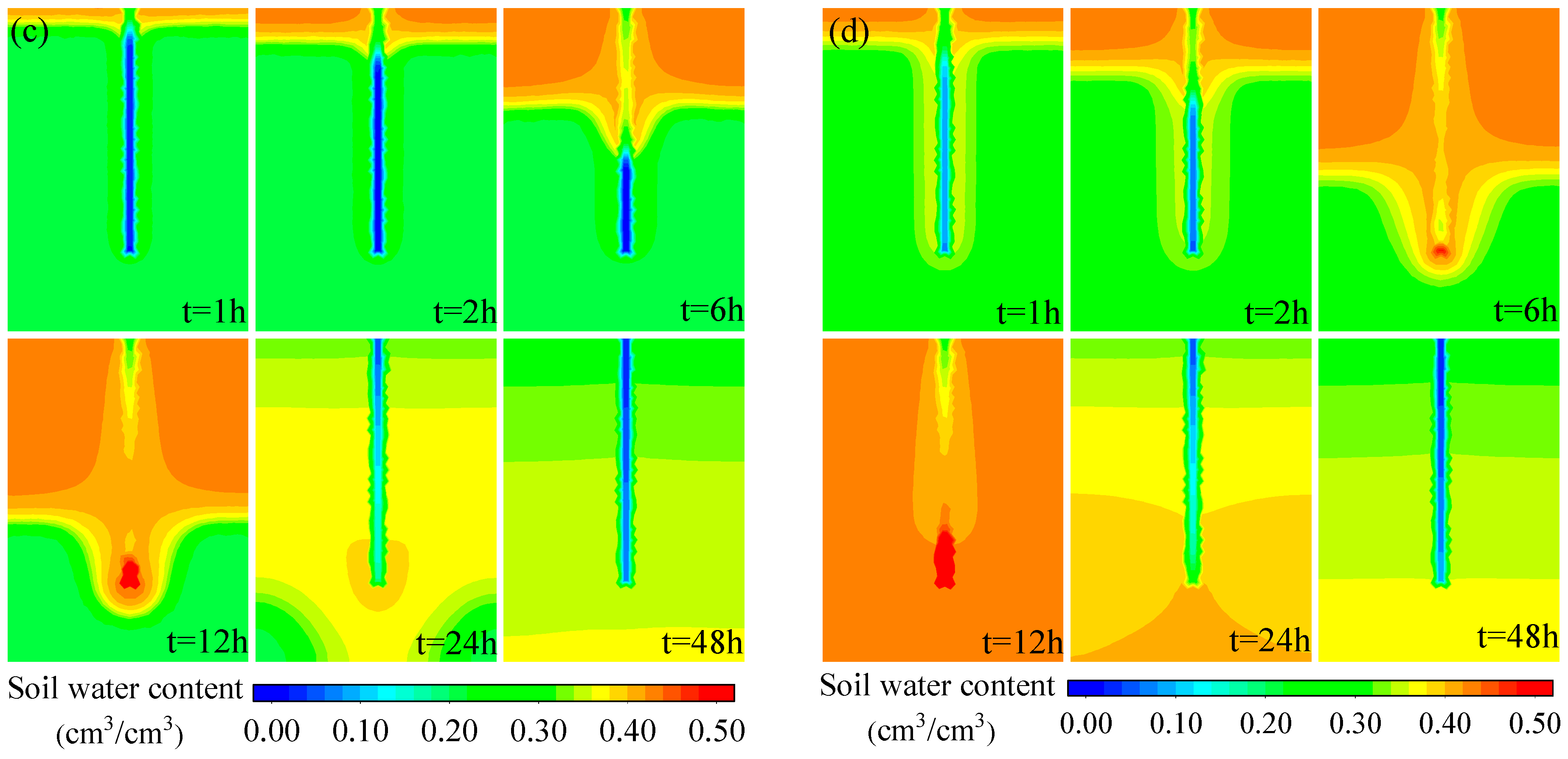
In this study, to explore the impact of rainfall intensity on the preferential flow process in macropores, scenarios were set with rainfall intensities of 0.5 cm/h, 1 cm/h, 1.5 cm/h, and 2 cm/h (initial soil water content q₀ = 0.15 cm3/cm3, crack width L = 1 cm). The 1st, 2nd, 6th, 12th, 24th, and 48th hours during the study period were selected as representative time points to analyze the preferential flow process. The results are presented in Figure 4a–d.
Figure 4a–d illustrates that variations in rainfall intensity and initial water content exert similar effects on the spatial and temporal distribution of water content within the profiles. These similarities can be attributed to large pore channels, facilitating a pronounced preferential flow phenomenon during rainfall infiltration. Notably, at the 12th hour of the simulation, the different rainfall scenarios exhibited a marked preferential flow phenomenon. In scenarios with varying initial water content, the rainfall infiltration depths exceeded 80 cm across the model profiles. Furthermore, at corresponding time intervals during the simulation, the depth of the soil wetting front progressively increased in tandem with rising rainfall intensity. For instance, at the twelfth hour, the depths of the wetting front corresponding to rainfall intensities of 0.5 cm/h, 1.0 cm/h, 1.5 cm/h, and 2.0 cm/h were 32 cm, 63 cm, 79 cm, and greater than 80 cm, respectively. This increase in rainfall intensity accelerates the migration rate of precipitation within both the matrix and macropores of the soil, resulting in a greater depth of the soil wetting front.

3.1.3. Different Cracks Width

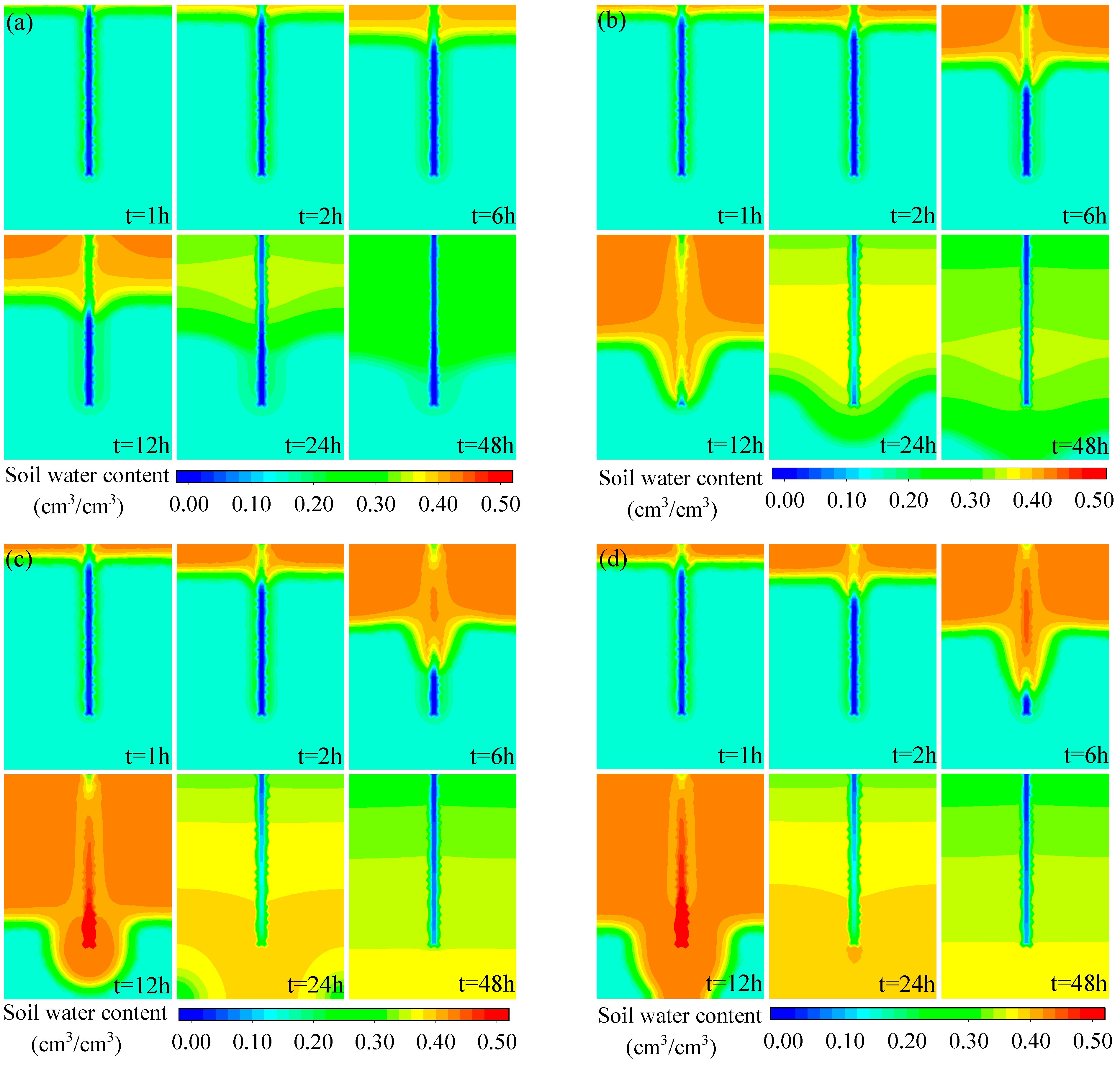
In this study, to investigate the impact of varying crack widths on the preferential flow process in large pores, scenarios with crack widths of 0.5 cm, 1.0 cm, 1.5 cm, and 2.0 cm were established, with a rainfall intensity (P) of 1.0 cm/h and an initial soil water content (q₀) of 0.15 cm3/cm3. Typical time intervals, precisely 1 h, 2 h, 6 h, 12 h, 24 h, and 48 h, were selected for analyzing the preferential flow dynamics. The results of this analysis are presented in Figure 5a–d.
Figure 5a–d indicates that the effects of varying rainfall amounts and initial water contents on the distribution of water content changes in the profiles exhibit similar characteristics. This is primarily attributable to large pore channels, facilitating a pronounced preferential flow phenomenon during rainfall infiltration. Notably, at the twelfth hour of the simulation, different rainfall scenarios demonstrated a distinct preferential flow phenomenon. At the same time, the profiles with varying initial water content showed rainfall infiltration depths exceeding 80 cm. Additionally, at corresponding time intervals throughout the simulation, the depth of the soil wetting front increased progressively with rising rainfall intensity. For instance, at the twelfth hour, the depths reached by the wetting front for rainfall intensities of 0.5 cm/h, 1.0 cm/h, 1.5 cm/h, and 2.0 cm/h were 32 cm, 63 cm, 79 cm, and greater than 80 cm, respectively. This increase in rainfall intensity accelerates the precipitation migration rate within the soil’s matrix and macropores. As a result, the depths of the soil-wetting front increase.

3.2. Response of Maximum Water Content and Wetting Front Depth Variations to Different Scenarios

To further elucidate the impact of rainfall variations on the preferential flow process, the maximum water content in the substrate area and the corresponding depth of the wetting front were quantified across different scenarios. The results are presented in Table 4, Table 5 and Table 6.
Table 4 demonstrates that the maximum soil water content in the substrate area was observed in the topsoil layer during the first 12 h of rainfall. After the rainfall period (12th hour), the maximum soil water content for scenarios A1 and A2 was recorded in the topsoil layer (H = 0 cm), both achieving a maximum value of 0.436 cm3/cm3. In contrast, the maximum soil water content for scenarios A3 and A4 occurred at the maximum length of the macropores, reaching 0.437 cm3/cm3. Following the cessation of rainfall, the maximum soil water content was noted at increasingly deeper depths, with higher initial water contents corresponding to greater depths. For instance, at the 48th hour of the simulation, the depths at which maximum water content occurred for scenarios A1 to A4 were 34 cm, 44 cm, 78 cm, and 80 cm, respectively. As the initial soil water content increased, the infiltration depth in the matrix zone and the macropores rose to varying degrees. However, the increase in macropore infiltration depth was significantly more significant than that in the matrix zone.
A comparison of the data presented in Table 4 and Table 5 reveals similarities in the maximum water content locations corresponding to different rainfall amounts and initial soil water contents. The maximum soil water content in the substrate zone was observed during the rainfall period at the soil surface. At the twelfth hour of the simulation, the maximum soil water content for scenarios B1 and B2 was recorded in the topsoil layer (H = 0 cm), with values of 0.425 cm3/cm3 and 0.436 cm3/cm3, respectively. In contrast, the maximum soil water content for scenarios B3 and B4 occurred near the maximum length of the macropores, with the maximum water content in the matrix zone reaching 0.437 cm3/cm3.
Table 6 presents data that differ from those in Table 4 and Table 5, as the maximum soil water content in the matrix area for Scenarios C1 to C4 occurs at the soil surface both during and immediately after the cessation of rainfall. Throughout the simulation period, the depth at which the maximum water content was achieved remained consistent across scenarios C1 to C4. The overall trend observed at the corresponding time intervals for these scenarios indicated that as the width of the cracks increased, the infiltration depth in the matrix zone showed only slight increases. Similarly, the depth of infiltration in the macropores also exhibited slight increases.

3.3. Response of Water Distribution Characteristics of Loess at Observation Points to Different Scenarios

3.3.1. Soil Water Content

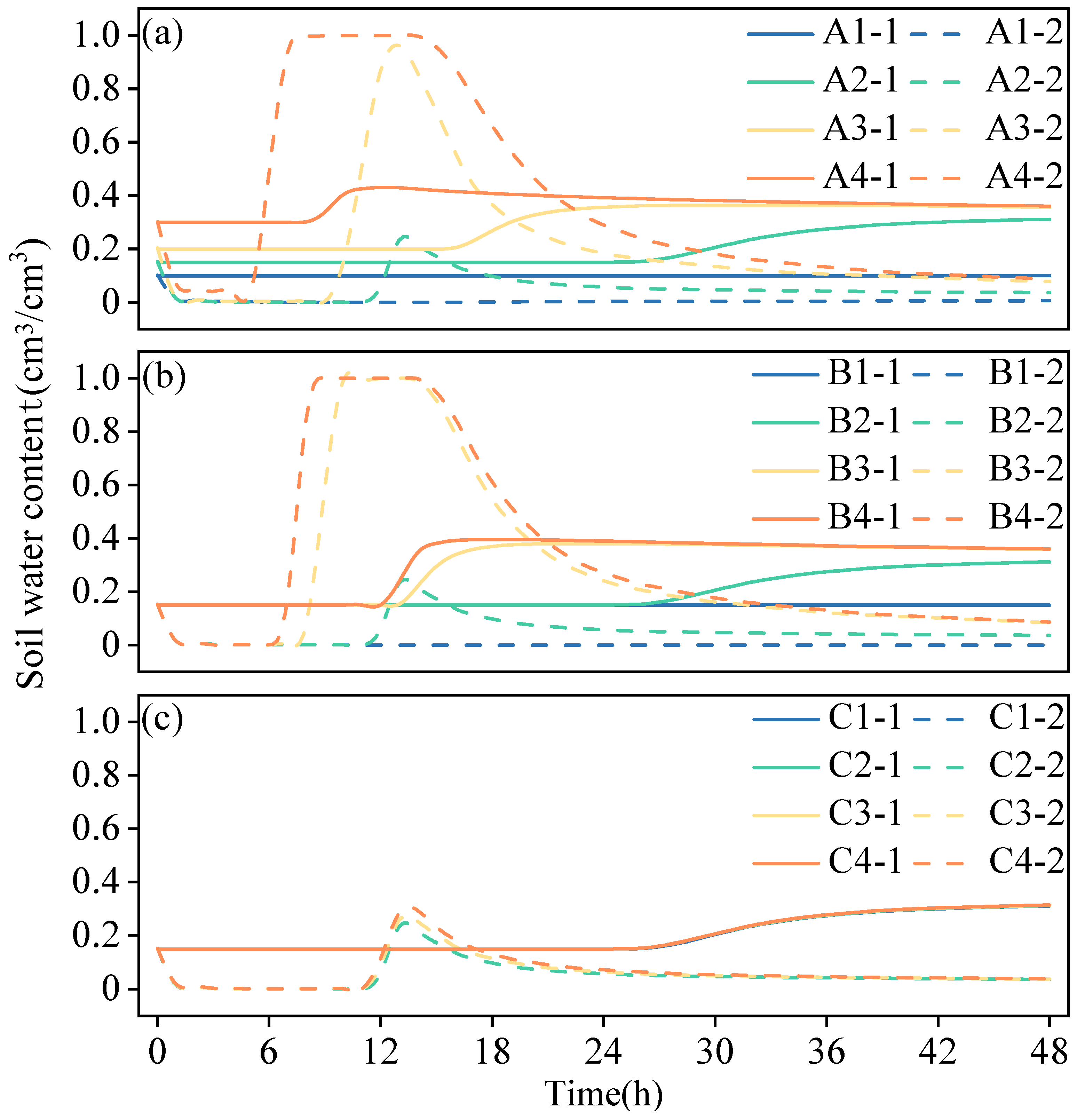
Two observation points were established within the simulation area for each scenario to investigate changes in soil water content in macropores during rainfall infiltration. The first observation point (0, 20) was positioned at a depth of 60 cm below the surface along the left zero flux boundary. The second observation point (30, 20) was located at the bottom of the macropore, 30 cm horizontally from the first observation point (as illustrated in Figure 2). The results of this analysis are presented in Figure 6.
As shown in Figure 6, the overall trend of the first observation point in scenarios A, B, and C is to gradually increase and stabilize at a certain water content. The water content of the second observation point in Scenarios A, B, and C has roughly the same trend, with a sudden drop to 0 from the beginning of the simulation. Subsequently, due to rainfall, the second observation point of all scenarios will tend to increase, then decrease, and finally stabilize at a certain water content. The difference is that in Figure 6a, scenario A1, with an initial soil water content of 0.1 cm3/cm3, does not respond to rainfall. Observations A2-1 to A4-1 had a shorter response time to rainfall with increasing soil water content and reached a stabilized moisture content faster. For sites A2-2 to A4-2, as soil water content increases, the response time of site moisture content to rainfall becomes shorter. The moisture content reached is more extensive, and the time required to stabilize at the maximum moisture content is extended. In the later stages of the simulation, the decrease in moisture content slows down. The trend of the two observation points in Figure 6b with different rainfall amounts is similar to the scenario in Figure 6a with different initial soil water contents. In both cases, an increase in rainfall corresponds to an increase in soil water content. In Figure 6c, the trends of the two observations in all scenarios in Scenario C are the same. This is consistent with the results analyzed in Section 3.1.3. Additionally, the observations show a high degree of overlap.

3.3.2. Cumulative Soil Water Flux

Due to the different simulation scenarios, the water transport patterns obtained from the model simulations vary. In this study, to investigate the differences in simulation results across various scenarios, two observation points at the exact locations (as described in Section 2.3.2) were selected in each scenario. The distribution characteristics of water flux at the two observation points under different scenarios were analyzed. Fitted curves were applied to the simulation data. The changes in cumulative soil water flux at the observation points over time for various scenarios are shown in Figure 7.
The fitted curves of water fluxes at different observation points under various scenarios are shown in Figure 7. The fitted curves for the observation points (0, 20) in Figure 7a–c are highly similar in terms of trend and direction and are all gentle, straight lines. In Figure 7a,b, the fitted curves for the observation points (30, 20) have similar opening directions and rising trends and rise faster. In contrast, the fitted curve for the observation point (30, 20) in Figure 7c increases more slowly. This indicates that the initial soil moisture content and rainfall have a more significant influence on the change of accumulation at the (30, 20) observation point than the width of the cracks.
In Figure 7a, the cumulative change of (0, 20) observation point gradually changes from 0.004 cm to 1.000 cm, 2.762 cm, and 6.987 cm. In Figure 7b, cumulative volume change gradually changes from 0.009 cm to 1.000 cm, 3.965 cm, and 4.640 cm. Then, in Figure 7c, accumulation continued at around 1.000 cm. This phenomenon indicates that due to the influence of macropores, the cumulative flux near the observation point in the matrix area does not show significant differences with the initial soil water content, rainfall, and crack width. In addition, the cumulative fluxes at the observation point of (30, 20) in Figure 7a varied from 0.126 cm to 103.104 cm. The variation of cumulus in Figure 7b ranged from 0.025 cm to 106.865 cm. The cumulative amount in Figure 7c varies from 5.657 cm to 9.294 cm. It can be seen that the cumulative amount at (30, 20) in Figure 7a,b is more than ten times that in Figure 7c. This phenomenon aligns with the conclusion in Section 3.1.3. It suggests that the effect of the width of the cracks on preferential flow is relatively small when the rainfall and initial water content are specific. By comparing the specific numerical changes in accumulation at the two observation points, it is shown that the accumulation below the large pore channel is significantly more significant than that in the matrix area.
From the above research results, it can be seen that by establishing a dual-permeability model, the preferential flow process of loess can be effectively portrayed. The simulation results confirm that the presence of large pores in the soil will significantly accelerate the infiltration rate of soil moisture, increase the cumulative flux near the large pores, and then increase the water content at the large pores. By studying the effects of changes in initial soil water content, rainfall, and crack width on the preferential flow process in loess macropores. It helps to clarify further the water cycle law of loess air-bearing belts, which can support regional irrigation water use and other work.

4. Discussion

4.1. Simulation and Verification of Preferential Flow Process

In this study, the preferential flow process in loess under different scenarios was simulated by combining field experiments and indoor experiments, using staining tracer experiments and the HYDRUS-2D/3D model, aiming to reveal the characteristics of the moisture distribution in loess at different observation points. Field dye tracer experiments visually captured the dynamic changes of the preferential flow path and wetting front. The fitted parameters, extracted from the SWCC of the matrix and preferential flow areas, provided key data support. This data was crucial for model calibration and validation of the preferential flow process. The study’s results showed that the wetting front’s depth and the cumulative water flux in the preferential flow in loess soils were significantly influenced by the initial water content and rainfall intensity. This is consistent with the study by Dario et al. [33] using HYDRUS-2D/3D to simulate preferential flow in olive orchard soils, emphasizing the decisive role of initial water content on the depth of the wetting front. However, this study further refined the effect of crack width on preferential flow. It was found that the impact of crack width on the depth of the wetting front is relatively tiny when other conditions are constant. This provides an essential reference for optimizing the parameters of the two-domain model. At the same time, Beven & Germann [10] showed that the formation of preferential flow is mainly associated with macropores in the soil structure and proposed that there is a significant difference between macropore fluxes and matrix fluxes. This study’s simulation results align with this. They show that the cumulative water flux in the macropore region is significantly higher than in the matrix region. The higher the initial water content, the more significant the preferential flow effect. In addition, this study further quantifies the influence of crack width on the depth of the wetting front and moisture distribution. It was found that crack width has less effect on the preferential flow within a specific range, thus providing a new basis for model parameter optimization. This study also validates and extends the conclusions of Xu et al. [50] on the influence of fracture morphology and continuity on preferential flow paths. Through field staining experiments and multi-scenario simulations (including variations in initial water content and rainfall intensity), this study confirms the importance of fracture conditions on the dynamics of wetting fronts. It also expands the analysis by considering fracture width as a variable. This makes the results more generalizable and practically instructive. Naglic et al. [53] used HYDRUS-2D/3D to simulate the wetting patterns of soils with different textures and pointed out that higher initial water content leads to larger wetting patterns. Fan et al. [54] simulated the distribution pattern of soil water content under drip irrigation conditions by HYDRUS-2D/3D. They revealed the significant effect of initial water content on the migration distance of wetting fronts. In this study, based on the hydraulic parameters obtained from SWCC fitting, soil water content simulation accuracy at different depths increased significantly with depth. This may be related to the spatial variability of evapotranspiration in the field, which leads to some bias in the simulation of the surface soil. Still, the HYDRUS-2D/3D model showed higher accuracy for the deeper soil with more stable environmental conditions.

4.2. Improvement and Optimization of the Model

This study used a dual-permeability model better to simulate the coupling process between matrix and preferential flow. Still, the model assumes that the macropore fracture has regular morphology, which does not fully reflect the complex pore network characteristics in the natural environment. The macropores fractures in loess layers have variable morphology and irregular distribution, which may lead to the deviation of the model results from the actual situation. For example, Xu et al. [50] simulated the wetting front dynamics of macropores under different tortuosity and continuity conditions by HYDRUS-2D/3D. The results show that the simulation error (MRE) is about 5%, and R2 reaches 0.9, which verifies the model’s validity. However, it also suggests that the influence of natural fracture complexity should be considered in practical applications. The simulation time of this study is 48 h, which focuses on the short-term moisture transport process during rainfall events. Although the results are consistent with the trend of the 500-h-long simulation of Jiang et al. [55] the limitation of the study’s time scale may lead to a lack of understanding of the long-term dynamic changes. Zhao et al. [56] wet-dry cycling significantly affects soil fissure dynamics, especially at the beginning of the cycle, with significant fluctuations in wetting front depth and preferential circulation. Although the wet-dry cycle was not directly modeled in this study, it was observed that higher initial water content significantly shortened the response time of the wetting front during a short rainfall period. This finding is consistent with some of the results of Zhao et al. Future studies can complement these gaps through long-time-scale simulations, especially to analyze the long-term effects of seasonal and interannual climate change on preferential flow processes. The preferential flow phenomenon in loess may show significant differences under different seasonal and climatic conditions. This is especially true under the long-term effects of the dry-wet cycle, where soil structure may change significantly. Such changes can alter the paths and rates of water transport [37,57,58]. In addition, regular pore morphology is assumed in the existing models. To some extent, this simplification ignores the irregularities of pore fractures in loess. These irregularities include the diversity of fracture morphology, the discontinuity of distribution, and the dynamic evolution process [50]. Future studies should introduce more complex and realistic pore morphology and try to incorporate three-dimensional modeling to more accurately reflect the effect of soil pore networks on preferential flow. Regarding regional applicability, this study is based on experimental data of loess in Lantian County, Xi’an, as a typical region in the southern part of the Loess Plateau, and the results are representative [59]. However, the distribution of loess in the different areas and their structure and hydrological properties are pretty different [60]. Therefore, the applicability of the results of this study to other areas needs to be further verified. Future research should combine multi-point observations and experiments to modify the model parameters and optimize the regional applicability to improve the model’s general prediction ability in different loess areas. In addition, this study mainly focuses on the effect of macropore fissures on water transport. It does not fully consider the role of vegetation cover, agricultural cultivation, and land management measures. In actual loess areas, vegetation root systems can significantly influence soil fissure formation and preferential flow paths. Meanwhile, tillage practices and land use management measures further alter soil structure and water transport patterns. Neglecting these factors may lead to an incomplete understanding of preferential flow processes. Future studies should explore the effects of different land-use practices on the preferential flow phenomenon. Specifically, they should focus on the interaction between vegetation root systems and soil fissures. This will provide a more practical scientific basis for water resource management and soil conservation in loess areas. In actual loess areas, vegetation root systems can significantly influence soil fissure formation and preferential flow paths. Meanwhile, tillage practices and land use management measures further alter soil structure and water transport patterns [61,62]. Neglecting these factors may lead to an incomplete understanding of preferential flow processes. Future studies should explore the effects of different land-use practices on the preferential flow phenomenon. This should focus on the interaction between vegetation root systems and soil fissures. The goal is to provide a more practical scientific basis for water resource management and soil conservation in loess areas.

4.3. Regional Applicability and Future Research Directions

Cai et al. [63] investigated the impact of the acacia root system on preferential flow across different forest ages. They found that the root system significantly improved soil structure, enhancing the preferential flow effect, which provided valuable insights into the role of vegetation in preferential flow in loess areas. Similarly, Kan et al. [64] used the Hydrus-2D/3D model to study the effect of the acacia root system on preferential flow in various forest ages. They confirmed that root-induced soil structure improvements significantly enhanced the preferential flow. This study focused on the influence of crack width and initial water content. However, its vegetation parameterization approach could be applied to improve the model’s ability to characterize interactions between vegetation and cracks. To develop a more refined and widely applicable preferential flow model, future research could explore the following aspects: (1) High-precision technologies such as CT scanning and 3D reconstruction are introduced to capture complex pore morphology and improve the simulation accuracy of the model for the coupling process of matrix flow and preferential flow. (2) Conduct multi-point observation and experiment in different loess areas, optimize model parameters, and improve its cross-regional applicability. (3) The extended time scale, combined with the climate change prediction model, to simulate the long-term dynamic effects of dry and wet cycles and seasonal changes on the preferential flow. (4) It is to comprehensively consider the mechanism of vegetation root and land use management on preferential flow, combined with the optimization model of agricultural management measures, to predict the process of soil moisture migration and to guide agricultural irrigation and ecological restoration practice. Multi-dimensional deepening research in technical means, research scope, and time scale can provide solid theoretical and technical support for water resource management, soil conservation, and agricultural development in loess areas.

5. Conclusions

This study combined field investigation and indoor analysis methods to investigate Xi’an loess’s soil moisture characteristic curve and other hydraulic parameters. The Hydrus-2D/3D model was used to construct a coupled matrix-macropore dual-permeability model in the experimental area and analyze the water transport process under different initial soil water content, rainfall intensity, and crack width scenarios. The main conclusions are as follows: (i) A dual-permeability model for the preferential flow of loess was constructed based on the dyeing tracer and SWCC test for the phenomenon of preferential flow of loess macropore during precipitation, and the boundary conditions and scenario design of the model were set. (ii) The simulation results indicate a straightforward preferential flow process in the profile due to macropore channels. Additionally, initial soil water content and rainfall intensity significantly influence soil moisture’s spatial and temporal distribution throughout the simulation. The greater the initial soil moisture content, the more rainfall, the faster the rate of precipitation migration in the soil, and the greater the depth reached by the soil wetting front. (iii) The water content dynamics and water fluxes at the two localized observation points show that the response time of water content to rainfall at the observation points is shorter as the soil water content increases. The cumulative flux below the macropore channels was significantly more prominent than in the substrate zone. Future research should be further deepened in multiple dimensions such as technical means, research scope, and time scale. Future research should be further deepened in various dimensions such as technical means, research scope, and time scale. This systematic exploration will provide a theoretical basis and technical support for water resource management, soil conservation, and sustainable agricultural development in loess areas. At the same time, it lays a scientific basis for realizing the synergistic promotion of regional ecological protection and economic growth.

Author Contributions

S.L.: Writing-original draft, Investigation.; T.L.: Methodology, Investigation.; K.Z.: Visualization, Data curation.; Y.G.: Data curation, Formal analysis.; B.W.: Data curation, Investigation.; Y.L.: Supervision, Funding acquisition. All authors have read and agreed to the published version of the manuscript.

Funding

This research was funded by the National Natural Science Foundation of China (grant number: U2243204).

Data Availability Statement

Data is contained within the article.

Conflicts of Interest

The authors declare that they have no known competing financial interests or personal relationships that could have appeared to influence the work reported in this paper.

References

  1. Huang, J.P.; Zhang, W.; Zuo, J.Q.; Bi, J.R.; Shi, J.S.; Wang, X.; Chang, Z.L.; Huang, Z.W.; Yang, S.; Zhang, B.D.; et al. An Overview of the Semi-arid Climate and Environment Research Observatory over the Loess Plateau. Adv. Atmos. Sci. 2008, 25, 906–921. [Google Scholar]
  2. Feng, S.; Fu, Q. Expansion of global drylands under a warming climate. Atmos. Chem. Phys. 2013, 13, 10081–10094. [Google Scholar] [CrossRef]
  3. Ravi, S.; Breshears, D.D.; Huxman, T.E.; D’Odorico, P. Land degradation in drylands: Interactions among hydrologic-aeolian erosion and vegetation dynamics. Geomorphology 2010, 116, 236–245. [Google Scholar]
  4. Torres, L.; Abraham, E.M.; Rubio, C.; Barbero-Sierra, C.; Ruiz-Pérez, M. Desertification Research in Argentina. Land Degrad. Dev. 2015, 26, 433–440. [Google Scholar]
  5. Belaroui, K.; Djediai, H.; Megdad, H. The influence of soil, hydrology, vegetation and climate on desertification in El-Bayadh region (Algeria). Desalin. Water Treat. 2014, 52, 2144–2150. [Google Scholar]
  6. D’Odorico, P.; Bhattachan, A.; Davis, K.F.; Ravi, S.; Runyan, C.W. Global desertification: Drivers and feedbacks. Adv. Water Resour. 2013, 51, 326–344. [Google Scholar]
  7. Kebre, M.B.; Cherblanc, F.; Ouedraogo, F.; Jamin, F.; Naon, B.; Zougmore, F.; Benet, J.C. Water flow in soil at small water contents: A simple approach to estimate the relative hydraulic conductivity in sandy soil. Eur. J. Soil Sci. 2017, 68, 167–176. [Google Scholar]
  8. Bayad, M.; Chau, H.W.; Trolove, S.; Moir, J.; Condron, L.; Bouray, M. The Relationship between Soil Moisture and Soil Water Repellency Persistence in Hydrophobic Soils. Water 2020, 12, 12. [Google Scholar] [CrossRef]
  9. Nakhaei, M.; Simunek, J. Parameter estimation of soil hydraulic and thermal property functions for unsaturated porous media using the HYDRUS-2D code. J. Hydrol. Hydromech. 2014, 62, 7–15. [Google Scholar]
  10. Beven, K.; Germann, P. Macropores and water flow in soils revisited. Water Resour. Res. 2013, 49, 3071–3092. [Google Scholar]
  11. Guan, N.; Cheng, J.H.; Shi, X.Q. Preferential Flow and Preferential Path Characteristics of the Typical Forests in the Karst Region of Southwest China. Forests 2023, 14, 17. [Google Scholar] [CrossRef]
  12. Weiler, M. Macropores and preferential flow-a love-hate relationship. Hydrol. Process. 2017, 31, 15–19. [Google Scholar] [CrossRef]
  13. Brunetti, G.F.A.; Maiolo, M.; Fallico, C.; Severino, G. Unraveling the complexities of a highly heterogeneous aquifer under convergent radial flow conditions. Eng. Comput. 2024, 40, 3115–3130. [Google Scholar]
  14. Yetbarek, E.; Kumar, S.; Ojha, R. Effects of soil heterogeneity on subsurface water movement in agricultural fields: A numerical study. J. Hydrol. 2020, 590, 15. [Google Scholar] [CrossRef]
  15. Bauser, H.H.; Kim, M.; Ng, W.R.; Bugaj, A.; Troch, P.A. Richards Equation at the Hillslope Scale: Can We Resolve the Heterogeneity of Soil Hydraulic Material Properties? Water Resour. Res. 2022, 58, 18. [Google Scholar]
  16. Peng, W.B.; Wang, Z.; Song, Y.G.; Pfaff, K.; Luo, Z.; Nie, J.S.; Chen, W.H. A comparison of heavy mineral assemblage between the loess and the Red Clay sequences on the Chinese Loess Plateau. Aeolian Res. 2016, 21, 87–91. [Google Scholar]
  17. Zhang, L.X.; Qi, S.W.; Yu, Y.T.; Zhang, Y.G.; Li, Z.Q.; Hou, X.K.; Ma, L.N.; Zou, Y.; Guo, S.F.; Peng, J.B. A comparative study on the physical properties of natural sedimentary loess and manual filling compacted loess. Environ. Earth Sci. 2021, 80, 17. [Google Scholar] [CrossRef]
  18. Qiu, D.X.; Xu, R.R.; Wu, C.X.; Mu, X.M.; Zhao, G.J.; Gao, P. Vegetation restoration improves soil hydrological properties by regulating soil physicochemical properties in the Loess Plateau, China. J. Hydrol. 2022, 609, 12. [Google Scholar]
  19. Morianou, G.; Kourgialas, N.N.; Karatzas, G.P. A Review of HYDRUS 2D/3D Applications for Simulations of Water Dynamics, Root Uptake and Solute Transport in Tree Crops under Drip Irrigation. Water 2023, 15, 23. [Google Scholar] [CrossRef]
  20. Deb, S.K.; Shukla, M.K.; Simunek, J.; Mexal, J.G. Evaluation of Spatial and Temporal Root Water Uptake Patterns of a Flood-Irrigated Pecan Tree Using the HYDRUS (2D/3D) Model. J. Irrig. Drainage Eng-ASCE 2013, 139, 599–611. [Google Scholar]
  21. Li, T.C.; Shao, M.A.; Jia, Y.H.; Jia, X.X.; Huang, L.M. Small-scale observation on the effects of the burrowing activities of mole crickets on soil erosion and hydrologic processes. Agric. Ecosyst. Environ. 2018, 261, 136–143. [Google Scholar] [CrossRef]
  22. Yin, M.S.; Xiao, K.; Xin, P.; Li, H.L.; Zheng, C.M.; Smith, E.; Wilson, A.M. Randomly Distributed Crab Burrows Enhance Groundwater Flow and Salt Transport in Creek-Marsh Systems. Water Resour. Res. 2023, 59, 15. [Google Scholar] [CrossRef]
  23. Barbosa, L.A.P.; Gerke, K.M.; Gerke, H.H. Modelling of soil mechanical stability and hydraulic permeability of the interface between coated biopore and matrix pore regions. Geoderma 2022, 410, 8. [Google Scholar] [CrossRef]
  24. Soltanmohammadi, R.; Iraji, S.; de Almeida, T.R.; Basso, M.; Munoz, E.R.; Vidal, A.C. Investigation of pore geometry influence on fluid flow in heterogeneous porous media: A pore-scale study. Energy Geosci. 2024, 5, 17. [Google Scholar] [CrossRef]
  25. Huber, C.; Su, Y. A pore-scale investigation of the dynamic response of saturated porous media to transient stresses. Geofluids 2015, 15, 11–23. [Google Scholar] [CrossRef]
  26. Tartakovsky, D.M.; Lu, Z.; Guadagnini, A.; Tartakovsky, A.M. Unsaturated flow in heterogeneous soils with spatially distributed uncertain hydraulic parameters. J. Hydrol. 2003, 275, 182–193. [Google Scholar] [CrossRef]
  27. Houben, G.J.; Stoeckl, L.; Mariner, K.E.; Choudhury, A.S. The influence of heterogeneity on coastal groundwater flow—Physical and numerical modeling of fringing reefs, dykes and structured conductivity fields. Adv. Water Resour. 2018, 113, 155–166. [Google Scholar] [CrossRef]
  28. Cui, P.F.; Xie, H.P.; Wang, Z.H.; Hao, H.C.; Li, C.B.; Gao, M.Z. Implications of Local-Scale Approximations on Describing Fluid Flow in Rock Fractures With Stress-Induced Void Heterogeneity. Water Resour. Res. 2022, 58, 19. [Google Scholar] [CrossRef]
  29. Severino, G.; Leveque, S.; Toraldo, G. Uncertainty quantification of unsteady source flows in heterogeneous porous media. J. Fluid Mech. 2019, 870, 5–26. [Google Scholar] [CrossRef]
  30. Tobella, A.B.; Reese, H.; Almaw, A.; Bayala, J.; Malmer, A.; Laudon, H.; Ilstedt, U. The effect of trees on preferential flow and soil infiltrability in an agroforestry parkland in semiarid Burkina Faso. Water Resour. Res. 2014, 50, 3342–3354. [Google Scholar] [CrossRef]
  31. Benegas, L.; Ilstedt, U.; Roupsard, O.; Jones, J.; Malmer, A. Effects of trees on infiltrability and preferential flow in two contrasting agroecosystems in Central America. Agric. Ecosyst. Environ. 2014, 183, 185–196. [Google Scholar] [CrossRef]
  32. Maples, S.R.; Fogg, G.E.; Maxwell, R.M. Modeling managed aquifer recharge processes in a highly heterogeneous, semi-confined aquifer system. Hydrogeol. J. 2019, 27, 2869–2888. [Google Scholar] [CrossRef]
  33. Autovino, D.; Rallo, G.; Provenzano, G. Predicting soil and plant water status dynamic in olive orchards under different irrigation systems with Hydrus-2D: Model performance and scenario analysis. Agric. Water Manage. 2018, 203, 225–235. [Google Scholar] [CrossRef]
  34. Zhu, X.A.; Chen, C.F.; Wu, J.N.; Yang, J.B.; Zhang, W.J.; Zou, X.; Liu, W.J.; Jiang, X.J. Can intercrops improve soil water infiltrability and preferential flow in rubber-based agroforestry system? Soil Tillage Res. 2019, 191, 327–339. [Google Scholar] [CrossRef]
  35. Nanda, A.; Sen, S.; Jirwan, V.; Sharma, A.; Kumar, V. Understanding plot-scale hydrology of Lesser Himalayan watershedA field study and HYDRUS-2D modelling approach. Hydrol. Process. 2018, 32, 1254–1266. [Google Scholar] [CrossRef]
  36. Ebrahimian, H.; Noory, H. Modeling paddy field subsurface drainage using HYDRUS-2D. Paddy Water Environ. 2015, 13, 477–485. [Google Scholar] [CrossRef]
  37. Kadyampakeni, D.M.; Morgan, K.T.; Nkedi-Kizza, P.; Schumann, A.W.; Jawitz, J.W. Modeling Water and Nutrient Movement in Sandy Soils Using HYDRUS-2D. J. Environ. Qual. 2018, 47, 1546–1553. [Google Scholar] [CrossRef] [PubMed]
  38. Al-Salihi, Z.K.K.; Salim, S.B. Effect of lengthanddepthof thedriptapeon wetting front advance in the root zone of sunflowr using hydrus 2D/3D program. Iraqi J. Agric. Sci. 2023, 54, 768–776. [Google Scholar] [CrossRef]
  39. Trakal, L.; Kodesová, R.; Komárek, M. Modelling of Cd, Cu, Pb and Zn transport in metal contaminated soil and their uptake by willow (Salix × smithiana) using HYDRUS-2D program. Plant Soil 2013, 366, 433–451. [Google Scholar] [CrossRef]
  40. Varvaris, I.; Borgesen, C.D.; Kjærgaard, C.; Iversen, B.V. Three Two-Dimensional Approaches for Simulating the Water Flow Dynamics in a Heterogeneous Tile-Drained Agricultural Field in Denmark. Soil Sci. Soc. Am. J. 2018, 82, 1367–1383. [Google Scholar] [CrossRef]
  41. Selim, T.; Bouksila, F.; Hamed, Y.; Berndtsson, R.; Bahri, A.; Persson, M. Field experiment and numerical simulation of point source irrigation with multiple tracers. PLoS ONE 2018, 13, 15. [Google Scholar] [CrossRef]
  42. Latifi, M.; Etedali, H.R.; Soltani, M. Evaluation of the different soil management effects on salinity control in maize cropping by HYDRUS-2D. Soil Sci. Annu. 2023, 74, 11. [Google Scholar] [CrossRef]
  43. Geng, L.; Li, L.; Li, W.; Yang, C.F.; Meng, F.J. HYDRUS-2D simulations of water movement in a drip irrigation system under soilless substrate. Int. J. Agric. Biol. Eng. 2022, 15, 210–216. [Google Scholar] [CrossRef]
  44. Mguidiche, A.; Provenzano, G.; Douh, B.; Khila, S.; Rallo, G.; Boujelben, A. Assessing hydrus-2D to simulate soil water content (SWC) and salt accumulation under an SDI system: Application to a potato crop in a semi-arid area of central tunisia. Irrig. Drain. 2015, 64, 263–274. [Google Scholar] [CrossRef]
  45. Priya, R.Y.; Manjula, R. A review for comparing SWAT and SWAT coupled models and its applications. In Proceedings of the International Conference on Mechanical, Electronics and Computer Engineering (ICMECE)—Materials Science, Kancheepuram, India, 22 April 2020; Elsevier: Kancheepuram, India, 2021; pp. 7190–7194. [Google Scholar]
  46. Lagos, M.S.; Muñoz, J.F.; Suárez, F.I.; Fuenzalida, M.J.; Yáñez-Morroni, G.; Sanzana, P. Investigating the effects of channelization in the Silala River: A review of the implementation of a coupled MIKE-11 and MIKE-SHE modeling system. Wiley Interdiscip. Rev. Water 2024, 11, 17. [Google Scholar] [CrossRef]
  47. Yadav, B.; Krishnan, P.; Shafeeq, P.M.; Parihar, C.M.; Aggarwal, P. Modelling soil thermal regime in wheat using HYDRUS-2D under diversified maize-wheat-mungbean cropping system. Catena 2020, 194, 13. [Google Scholar] [CrossRef]
  48. Kan, X.Q.; Cheng, J.H.; Hu, X.J.; Zhu, F.F.; Li, M. Effects of Grass and Forests and the Infiltration Amount on Preferential Flow in Karst Regions of China. Water 2019, 11, 19. [Google Scholar] [CrossRef]
  49. Gerke, H.H.; Van Genuchten, M.T. A dual-porosity model for simulating the preferential movement of water and solutes in structured porous media. Water Resour. Res. 2010, 29, 305–319. [Google Scholar] [CrossRef]
  50. Xu, X.X.; Kalhoro, S.A.; Chen, W.Y.; Raza, S. The evaluation/application of Hydrus-2D model for simulating macro-pores flow in loess soil. Int. Soil Water Conserv. Res. 2017, 5, 196–201. [Google Scholar] [CrossRef]
  51. Wei, H.; Yang, Y.F.; Wang, J.Y.; Meng, Q.M.; Deng, Y.S. A comparison of preferential flow characteristics and influencing factors between two soils developed in the karst region of Southwest China. Soil Tillage Res. 2024, 241, 17. [Google Scholar] [CrossRef]
  52. Fredlund, D.G.; Xing, A. Erratum: Equations for the soil-water characteristic curve. Can. Geotech. J. 1994, 31, 1026. [Google Scholar]
  53. Naglic, B.; Kechavarzi, C.; Coulon, F.; Pintar, M. Numerical investigation of the influence of texture, surface drip emitter discharge rate and initial soil moisture condition on wetting pattern size. Irrig. Sci. 2014, 32, 421–436. [Google Scholar]
  54. Fan, Y.W.; Yin, W.F.; Yang, Z.W.; Wang, Y.X.; Ma, L.J. Moisture content distribution model for the soil wetting body under moistube irrigation. Water SA 2023, 49, 73–91. [Google Scholar]
  55. Jiang, X.J.; Chen, C.F.; Zhu, X.A.; Zakari, S.; Singh, A.K.; Zhang, W.J.; Zeng, H.H.; Yuan, Z.Q.; He, C.G.; Yu, S.Q.; et al. Use of dye infiltration experiments and HYDRUS-3D to interpret preferential flow in soil in a rubber-based agroforestry systems in Xishuangbanna, China. Catena 2019, 178, 120–131. [Google Scholar]
  56. Zhao, Y.; De Maio, M.; Vidotto, F.; Sacco, D. Influence of wet-dry cycles on the temporal infiltration dynamic in temperate rice paddies. Soil Tillage Res. 2015, 154, 14–21. [Google Scholar] [CrossRef]
  57. Jordan, C.S.; Daniels, J.L.; Langley, W. The effects of temperature and wet-dry cycling on water-repellent soils. Environ. Geotech. 2017, 4, 299–307. [Google Scholar] [CrossRef]
  58. Hajjat, J.; Sánchez, M. Instrumented Plate to Study Soil Cracking Dynamics during Wetting-Drying Cycles. J. Geotech. Geoenviron. Eng. 2021, 147, 13. [Google Scholar]
  59. Luo, Y.; Zhang, J.M.; Zhou, Z.; Aguilar-Lopez, J.P.; Greco, R.; Bogaard, T. Effects of dynamic changes of desiccation cracks on preferential flow:experimental investigation and numerical modeling. Hydrol. Earth Syst. Sci. 2023, 27, 783–808. [Google Scholar]
  60. Pan, W.S.; Zhao, T.Y.; Li, X. Priority connectivity model of loess microstructure and its significance for preferential flow. Rock Soil Mech. 2024, 45, 1709–1719. [Google Scholar]
  61. Uhlemann, S.; Peruzzo, L.; Chou, C.; Williams, K.H.; Wielandt, S.; Wang, C.; Falco, N.; Wu, Y.; Carr, B.; Meldrum, P.; et al. Variations in Bedrock and Vegetation Cover Modulate Subsurface Water Flow Dynamics of a Mountainous Hillslope. Water Resour. Res. 2024, 60, 19. [Google Scholar] [CrossRef]
  62. Kodesová, R.; Nemecek, K.; Zigová, A.; Nikodem, A.; Fér, M. Using dye tracer for visualizing roots impact on soil structure and soil porous system. Biologia 2015, 70, 1439–1443. [Google Scholar]
  63. Cai, L.; Wang, F.; Lin, Y.Y.; Long, Q.; Zhao, Y.L.; Han, J.Q.; Ge, W.Y.; Chen, H. Changes in preferential flow caused by root effects in black locust plantations of different stand ages in the semi-arid region of the Loess Plateau. J. Hydrol. 2024, 634, 13. [Google Scholar] [CrossRef]
  64. Kan, X.Q.; Cheng, J.H.; Zheng, W.G.; Zhangzhong, L.L.; Li, J.; Liu, C.B.; Zhang, X. Interpretation of Soil Characteristics and Preferential Water Flow in Different Forest Covers of Karst Areas of China. Water 2024, 16, 20. [Google Scholar] [CrossRef]
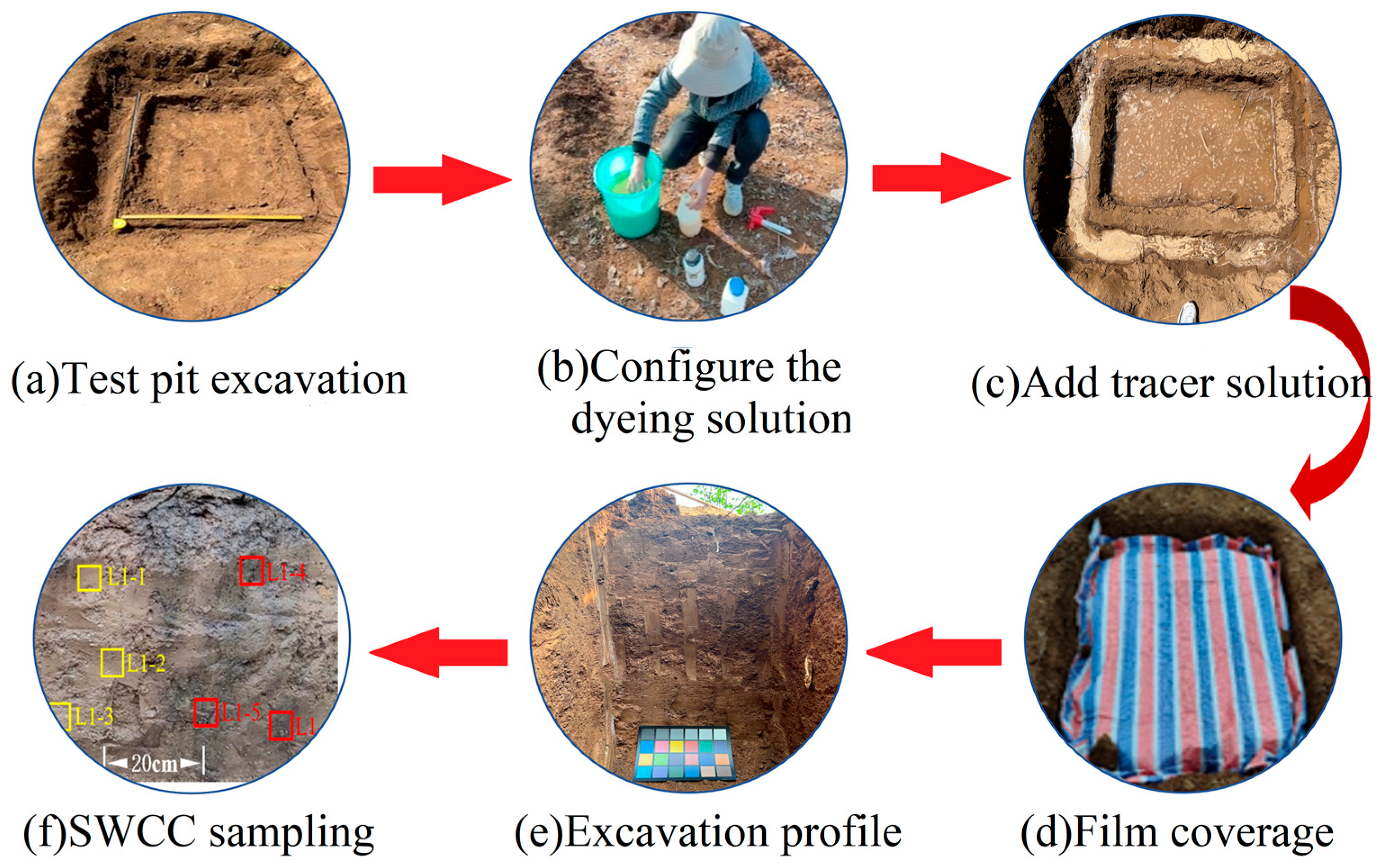
Figure 1. Dye tracer test of preferential flow of loess profile.
Water 16 03653 g001
Figure 2. Hydrogeological conceptual model of loess profile.
Water 16 03653 g002
Figure 3. Distribution of water content in profiles at different times: (a) θ0 = 0.1 cm3/cm3; (b) θ0 = 0.15 cm3/cm3; (c) θ0 = 0.2 cm3/cm3; (d) θ0 = 0.3 cm3/cm3.
Water 16 03653 g003aWater 16 03653 g003b
Figure 4. Water content distribution with different rainfall in the profiles: (a) P = 0.5 cm/h 3; (b) P = 1 cm/h; (c) P = 1.5 cm/h; (d) P = 2 cm/h.
Water 16 03653 g004
Figure 5. Water content distribution with different crack widths in the profiles: (a) L = 0.5 cm; (b) L = 1 cm; (c) L = 1.5 cm; (d) L = 2 cm.
Water 16 03653 g005
Figure 6. Variation of water content at observation points under different scenarios: (a) Scenario A, (b) Scenario B, and (c) Scenario C.
Water 16 03653 g006
Figure 7. Cumulative flux variation at observation points in different scenarios: (a) Scenario A, (b) Scenario B, and (c) Scenario C.
Water 16 03653 g007
Table 1. The Fredlund & Xing model’s parameters fit for soil characterization curves in the matrix flow region.
Loess Samplesθs(%)θr(%)αnmR
L1-149.18-6.142.140.530.971
L1-254.01-5.862.110.380.974
L1-351.63-6.012.500.550.988
Table 2. The Fredlund & Xing model’s parameters fit for soil characterization curves in the macropore flow region.
Loess Samplesa1n1m1a2n2m2
L1-411.262.910.82482.372.791.12
L1-513.183.230.47378.753.221.41
L1-612.943.880.38681.403.441.53
Table 3. Infiltration simulation under different scenarios.
Scenario SettingTreatmentVariable
Scenario A: different initial soil water content q0 (cm3/cm3)
rainfall intensity P = 1 cm/h
cracks width L = 1 cm
A1q0 = 0.1 cm3/cm3
A2q0 = 0.15 cm3/cm3
A3q0 = 0.2 cm3/cm3
A4q0 = 0.3 cm3/cm3
Scenario B: different rainfall intensity P (cm/h)
initial soil water content q0 = 0.15 cm3/cm3
cracks width L = 1 cm
B1P = 0.5 cm/h
B2P = 1 cm/h
B3P = 1.5 cm/h
B4P = 2 cm/h
Scenario C: different cracks width L (cm)
initial soil water content q0 = 0.15 cm3/cm3
rainfall intensity P = 1 cm/h
C1L = 0.5 cm
C2L = 1 cm
C3L = 1.5 cm
C4L = 2 cm
Scenario A: different initial soil water content q0 (cm3/cm3)
rainfall intensity P = 1 cm/h
cracks width L = 1 cm
A1q0 = 0.1 cm3/cm3
A2q0 = 0.15 cm3/cm3
A3q0 = 0.2 cm3/cm3
A4q0 = 0.3 cm3/cm3
Table 4. The profile’s maximum water content and depth of the wetting front (initial water content q0 = 0.1~0.3 cm3/cm3).
Scenario and q0 (cm3/cm3)Time (h)Maximum Soil Water Content in Substrate AreaWetting Front Depth (cm)
Depth
(cm)
Moisture Content (cm3/cm3)Wetting Front Depth (cm)Macropore Infiltration Depth (cm)
Scenario A1
q = 0.1
100.40637
200.425611
600.4361627
1200.4363453
24320.3664064
48340.3335167
Scenario A2
q = 0.15
100.41458
200.429814
600.4362232
1200.4364063
24420.3735375
48440.34365>80
Scenario A3
q = 0.2
100.421612
200.4321117
600.4362739
12600.4374872
24620.38858>80
48780.361>80>80
Scenario A4
q = 0.3
100.432815
200.4361525
6600.4374269
12600.437>80>80
24630.405>80>80
48800.366>80>80
Table 5. The maximal water content and depth of the wetting front in the profile (rainfall P = 0.5~2 cm/h).
Scenario and q0 (cm3/cm3)Time (h)Maximum Soil Water Content in Substrate AreaWetting Front Depth (cm)
Depth
(cm)
Moisture Content (cm3/cm3)Wetting Front Depth (cm)Macropore Infiltration Depth (cm)
Scenario A1
q = 0.1
100.37237
200.39459
600.4191318
1200.4252232
24190.3492658
48200.3143653
Scenario A2
q = 0.15
100.41458
200.429814
600.4362232
1200.4364063
24420.3735375
48440.34365>80
Scenario A3
q = 0.2
100.432411
200.4371019
600.4372961
12600.4374979
24620.39968>80
48780.365>80>80
Scenario A4
q = 0.3
100.437613
200.4371222
6250.4373061
12600.43754>80
24630.403>80>80
48800.366>80>80
Table 6. Maximal water content and depth of wetting front in the profile (cracks width L = 0.5~2 cm).
Scenario and q0 (cm3/cm3)Time (h)Maximum Soil Water Content in Substrate AreaWetting Front Depth (cm)
Depth
(cm)
Moisture Content (cm3/cm3)Wetting Front Depth (cm)Macropore Infiltration Depth (cm)
Scenario A1
q = 0.1
100.41358
200.429814
600.4362132
1200.4363963
24420.3725075
48440.34258>80
Scenario A2
q = 0.15
100.41458
200.429814
600.4362232
1200.4364063
24420.3735375
48440.34365>80
Scenario A3
q = 0.2
100.41449
200.429714
600.4362032
1200.4363864
24420.3735075
48440.34459>80
Scenario A4
q = 0.3
100.41459
200.429614
600.4362034
1200.4363865
24420.3735077
48440.34465>80
Disclaimer/Publisher’s Note: The statements, opinions and data contained in all publications are solely those of the individual author(s) and contributor(s) and not of MDPI and/or the editor(s). MDPI and/or the editor(s) disclaim responsibility for any injury to people or property resulting from any ideas, methods, instructions or products referred to in the content.