1. Introduction
Ponds and wetlands are significant features of flood management in the contemporary green infrastructure approach of urban water management [
1,
2]. They were also key elements for flood management in historical cities [
3]. We provide a case study of historical landscapes of ponds and wetlands in the cities of the lower Yellow River floodplain, which illustrates resilient and adaptive traditional practices to cope with floods and environmental changes, and the social connectivity and cultural diversity of these water features [
4]. We also review the 20th-century transformation through which the ecohydrological system of ponds and wetlands gradually lost their original diverse functions and adaptability. Understanding this history can help us rediscover the values of traditional ponds and wetlands landscapes, to expand the understanding of historical and cultural dimensions of contemporary green infrastructure. It also provides inspirations for today’s resilient and adaptive design of urban water landscapes to deal with fluctuating water levels and flood disasters [
5], and establishing diverse social connections with local communities.
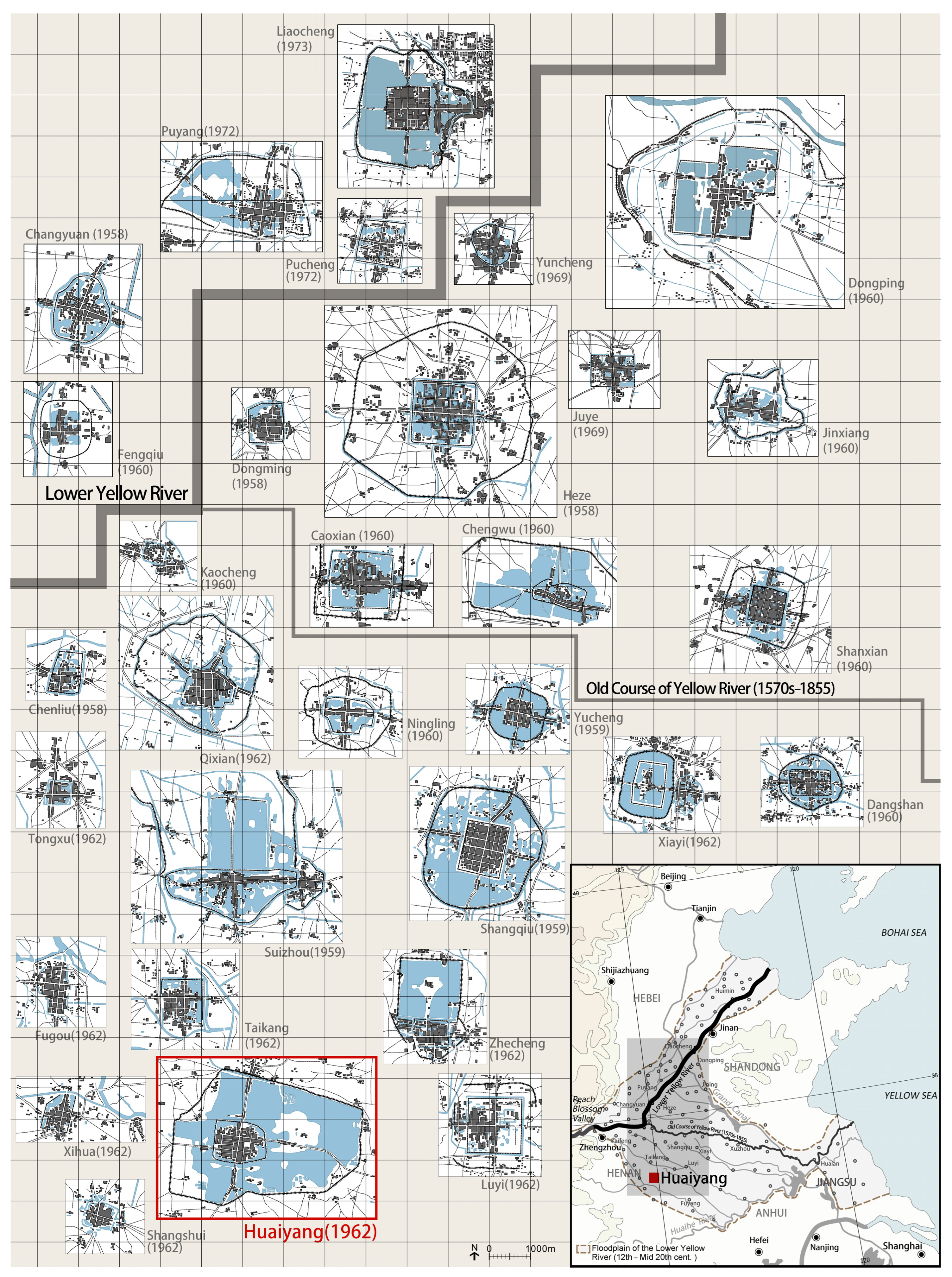
The lower Yellow River has been extremely dynamic over the past centuries, and its floodplain has been repeatedly inundated by highly sediment-charged floods, resulting in rapid rates of sediment deposition and frequent channel avulsions (sudden changes in river course), events that have profoundly affected Chinese history and culture [
6]. In response to channel changes and rapid rates of aggradation (build up of the river channel or floodplain by deposition of sediment), Chinese society developed distinctive flood adaptive urban landscapes [
7,
8,
9] (
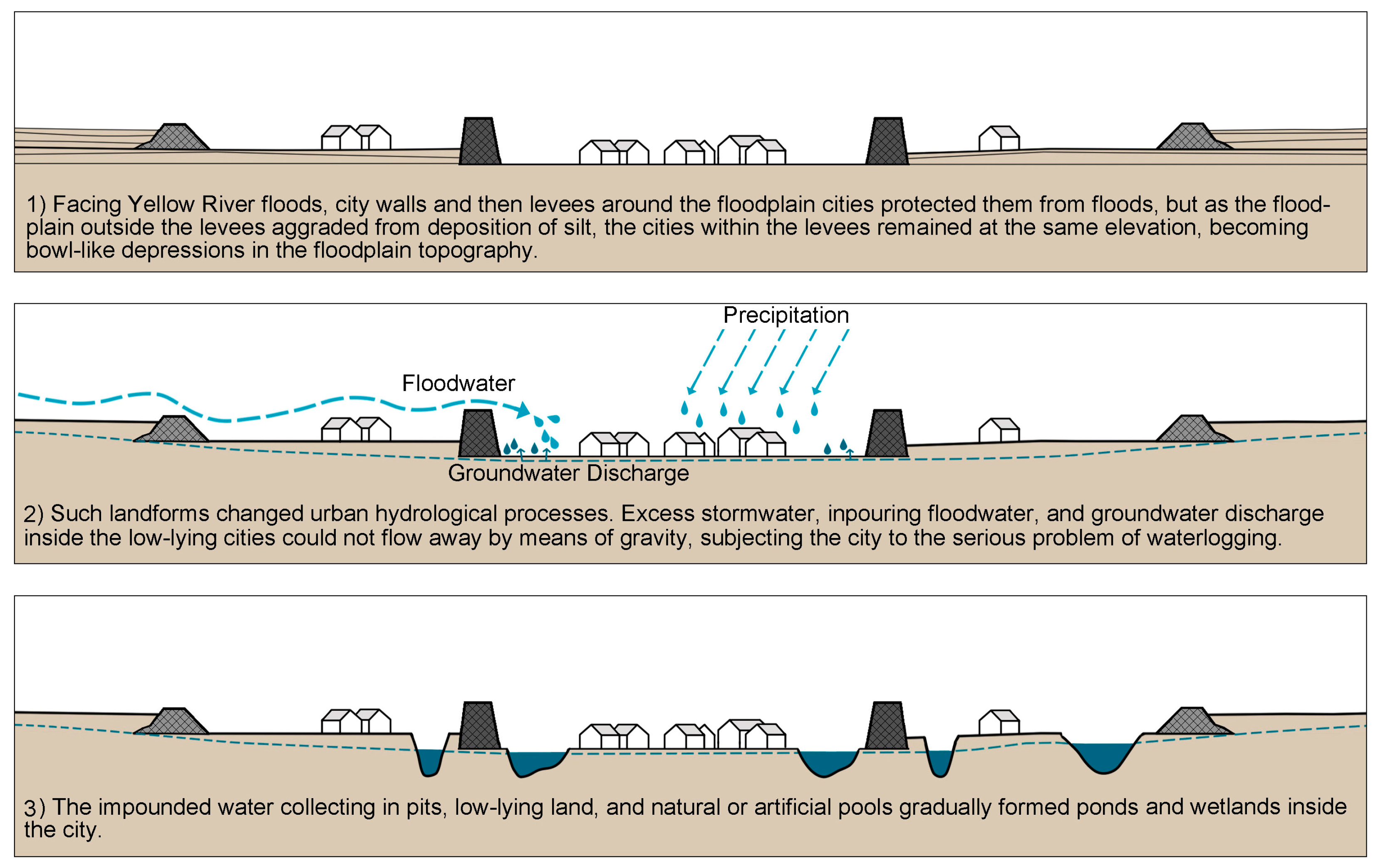
Figure 1). City walls and then levees around the cities protected them from floods, but as the floodplain outside the levees aggraded from deposition of silt, the cities within the levees remained at their original elevations, becoming bowl-like depressions in the floodplain topography. Within these “urban bowls”, water drained to ponds and wetlands (
Figure 2). These distinctive flood adaptive urban landscapes help the cities to survive in a harsh environment subject to periodic flood and drought, and created unique human habitats. Acting as flood water retention, ponds and wetlands were essential elements of the flood adaptive landscapes, and also played important roles in the daily lives of residents.
2. Methods
The city of Huaiyang is representative of many lower Yellow River floodplain cities in its historical development, and is especially well documented. It provides an excellent case study with which to explore the traditional pond and wetland landscapes that were well preserved until they underwent massive changes beginning in the late 1960s. We are fortunate to have abundant materials like satellite imagery, survey maps, government archives and the oral memory of local residents from the 1950s–1960s, so that we can draw upon and combine data from diverse sources to document the traditional water landscapes.
Specifically, we documented ancient landscapes using Huaiyang’s local gazetteers, going back to the mid-17th century, especially the edition of 1754 and of 1933. We also used other historical documents and archaeological excavation reports as a supplement. These materials are available at the National Library of China and related online resources. The ancient sources included not only narrative descriptions, but also manuscript maps and landscape paintings in local gazetteers, which allowed us to ‘triangulate’ on various features from the ancient landscapes, as they might be depicted by observers in different formats.
The 20th century brought more accurate mapping and satellite imagery, as well as the most rapid and profound changes. The earliest urban survey map of Huaiyang that used modern mapping methods was the 1:50,000 survey map of 1962 (obtained from National Geomatics Center of China), which provided accurate spatial information. We also found high-resolution and multi-temporal CORONA images of the 1960s (obtained from U.S. Geological Survey) that illustrated seasonal changes of wetland landscapes. To document changes after the 1970s, we used planning maps from local government and satellite images. We orthorectified all these images based on the 1962 survey map by QGIS 3.10, for drawing figures, and after comprehensive visual image interpretation, classification, and digitization of selected CORONA images, calculated the areal changes in wetlands and farmlands.
We also referred to recent materials, such as local government archives, reports and plans, and interviews with long-time residents. This allows us to draw a clearer picture of how changing agricultural practices, urbanization, and most recently, increased tourist development resulted in modification of the traditional uses into intensive agricultural landscapes, and then artificial recreational lakes, and then an ecological wetland park, reflecting similar transformation of ponds and wetlands in other lower Yellow River floodplain cities.
3. Traditional Ponds and Wetlands Landscapes of Huaiyang before the 1960s
3.1. Historical Development of Ponds and Wetlands in the City of Huaiyang
Huaiyang is located in eastern Henan province, on a low-lying, fertile, prosperous alluvial plain traversed by numerous waterways. The city was also referred to as ‘Chen’ or ‘Chenzhou’ historically. It was located on the banks of the Cai River–a distributary of the Yellow River and one of the most important waterways in the canal system of the North China Plain from the fourth century BC to the twelfth century AD [
10]. The foundation of the city likely dates from the Western Zhou dynasty (mid-eleventh century–771BC) [
11]. As typical of cites on the Lower Yellow River floodplain, the basic urban pattern was that of a city wall and an outer round levee to protect against floods, probably predating the ninth century [
12,
13]. The city had a strong relation with water throughout its history. It was an important port for inland water transportation, suffered from floods and waterlogging, and water has been an essential element in the urban landscape from early times to its present incarnation as a tourist destination (
Figure 3).
Historical accounts describe the city prior to the 12th century as low-lying and affected by floods and waterlogging, even before it was directly affected by distributaries of the Yellow River, which shifted southeast and began flowing past Huaiyang in 1234 [
14,
15]. A seasonal lake, Willow Lake, was documented in the northwest area outside the city wall [
16] (pp. 82–83) (
Figure 3). From 1234 until the late 1940s, the southerly course of the lower Yellow River meant that floods more directly affected the plain of eastern Henan province. The Cai River became an active floodway of the Yellow River from the thirteenth century to the mid-sixteenth century [
17] (pp. 431–435, 466–488), bringing severe flood disasters to Huaiyang [
18] (pp. 22–24) (
Figure 3). With accelerated deposition of silt outside the round levee, the city within the levees became even lower relative to the rest of the floodplain. Archaeological investigations indicate that the Yellow River deposited up to 5 m thickness of sediment since the twelfth century outside the levee, while the sedimentation is thin or even absent inside the levee and the city wall. The difference between the land level inside and outside the levee is now about 1–3 m [
19] (pp. 198–202).
The changes of urban land form led to the waterbodies expanding inside the levee with the rising water table. A historical account from 1486 described Nantan Lake to the south of Willow Lake and Beiguan Lake to the north [
20] (p. 314). By the 1660s, the area outside the city wall but within the levees was reported by various authors to be occupied entirely by lakes [
18] (pp. 402–403), [
21]. The survey map of Huaiyang in 1962 shows large areas of waterbodies between the levee and wall, about 6.29 km
2 in total, and inside the wall, about 0.18 km
2 in total. The waterbodies were essential for water retention in this low-lying floodplain city, and as described below, also of great value for the daily lives of local people (
Figure 3).
3.2. The Natural Conditions of Ponds and Wetlands: Hydrology, Topography, and Biodiversity
The waterbodies in Huaiyang city were referred to collectively as ‘City Lake’. While they might be huge lakes in the flood period, most of the year they consisted of a series of small ponds, swamps, and reed marshes. We use the terms ‘pond and wetland landscapes’ to describes these waterbodies, which had dynamic hydrological changes and fluctuating water levels in response to flooding (both pluvial flooding from local rainfall and riverine flooding from overflows of the Yellow River), evaporation, etc.
The abundant historical records of flooding in Huaiyang show that floods were an important resource for the ponds and wetlands. Flood waters could fill the entire area of the ponds and wetlands and could persist for months. In July 1931, a large flood on the Cai River caused the round levee of Huaiyang to collapse at three points, and the inpouring floodwater rapidly inundated nearly the whole area between the levee and the wall to depths of 1.3–3 m, except for the villages on higher ground. By October, the water was still 0.7–1.3 m deep. The city tried to drain the water away by breaking a part of the southern levee, but achieved no clear effect because of the large volume of water and the small difference In water level between the inner levee and the Cai River [
22].
Except during floods, these ponds and wetlands were hydrologically disconnected from surface waters of the Yellow and other rivers, and thus depended on storm water and groundwater. Consequently, they were strongly influenced by precipitation and evaporation. In the semi-humid and semi-arid monsoon climate of the lower Yellow River floodplain, the ponds and wetlands were seasonal waterbodies, alternating between drying and wetting. The seasonal drying out also led to salinization. The low-lying bowl-like landform inside the round levee resulted in poor drainage and high groundwater levels, which allowed salts to concentrate at the soil surface and in shallow waterbodies as water evaporated. As described in historical records, Huaiyang’s City Lake was a “vast expanse of whiteness (the dried salt-affected soils) in winter and spring, and vast expanse of water in summer and autumn” [
23].
CORONA satellite images of Huaiyang in the 1960s show seasonal fluctuations between drying and wetting of the ponds and wetlands landscapes, prior to their control by artificial water regulation starting in the 1970s. In rainy seasons and wet years, such as December 1962 and August 1964, the ponds expanded, but shrank in dry periods such as September 1967 and November 1968 [
24] (App.1, pp. 4–5). The areas of ponds and wetlands in the image of November 1968 (dry season) were only 35.6% of that in the image of August 1964 (wet season) (
Figure 4 and
Figure 5).
The images also show the landform of the ponds and wetlands landscapes. The spatial pattern of high lands can be seen on the images of wet years. It is evident that the city, all the villages, and a fair proportion of farmlands are on high ground, above the flooding while the ponds and wetlands swelled with water, becoming huge lakes. The images of dry years display the complicated bottom topography of the ponds and wetlands. The broken and undulating terrain provided diverse habitats for different species.
From descriptions in historical poems and essays on Huaiyang’s water landscapes, we can infer the wetlands were highly productive and diverse, with frequent mention of plants such as
Salix,
Nelumbo spp.,
Typha Linn, and
Phragmites, and animals such as
Anas,
Anser,
Grus,
Egretta, and
Cyprinidae [
18] (pp. 285–495). A recent biological survey found the Huaiyang City Lake wetland distinctive among the agricultural landscapes of the eastern Henan Plain and valuable for their biological diversity. Marsh habitat is dominated by
Cortaderia selloana,
Nelumbo nucifera,
Phragmites australis,
Triarrherca sacchariflora,
Euryale ferox,
Zizania latifolia,
Heleocharis dulcis, and
Lemna minor, while upland habitat is dominated by artificial and semi-artificial plant communities. The ponds support fish (mostly
Cyprinidae) and several common amphibians and reptiles. The wetlands also provide habitat for waterfowls and other migratory birds, including protected species like
Aix galericulata,
Anas platyrhynchos,
Grus grus, and
Egretta garzetta [
26].
3.3. Agriculture Production in Ponds and Wetlands
Official records of the 1960s document six settlements consisting of 15 villages and about 8000 villagers in the 10.34 km
2 area between the levee and the city wall, including about 2 km
2 of farmland, ranging from good farmland on high ground to poor lands at lower elevation [
23]. The crop production and livelihood of the villages and farmers closely relied on the ponds and wetlands, and adapted to and modified the landscape with various land uses. In practice, the actual planting areas could fluctuate with the changes of water levels, as clearly visible on the CORONA images of the 1960s: the planting area varied on each image, with only about 1.22 km
2 in August 1964 (showing highland fields that avoided inundation from summer storms), compared with 6.48 km
2 in November 1968, in the dry season of a dry year, which is 5.3 times that of the wet season extent of August 1964 (
Figure 4 and
Figure 5). The archives also recorded that local peasants used to cultivate the dried wetlands, whose soils were fertile thanks to the organic-rich sludge accumulated in the bottoms of these depressions. They also utilized the dried wetlands for grazing, and excavated the sludge for use as fertilizer on nearby farms or for sale to nearby villages [
23].
The adaptation of agricultural activities to the hydrological changes of ponds and wetlands is also seen in the selection of crop rotation sequences. Traditionally, the crop production in the City Lake area adopted the annual double-crop rotation system, planting wheat in October for harvest in June, then planting autumn grains (e.g., millet, sorghum, soybean, sweet potato, corn, buckwheat) from summer to autumn [
25]. This cropping system is common in this region, but in Huaiyang local farmers gave very high priority to wheat planting. They believed “a wheat harvest could be equivalent to three autumn grains harvest”. Because the growing period of wheat avoids the rainy season of summer and autumn, it could usually assure a relatively predictable harvest. Autumn grains were vulnerable to floods and storms and thus unreliable, as reflected in a local saying, “no harvest nine out of ten years”. Thus, if the wheat harvest is acceptable, the planting of autumn grains was often treated casually or even forgone, letting the land lie idle until the next wheat planting, especially in the lower farmlands [
27].
However, if the wheat harvest was poor due to excessive rainfall or drought, autumn grains could be an important food source. Most autumn grains have short growing periods and can withstand waterlogging and drought, making them adaptable to the unpredictable weather of summer and autumn. If rainfall ends in time, farmers could still plant and have a harvest before planting wheat in later autumn. Buckwheat, for example, whose growing period is only about 60 days, was traditionally regarded as an after-flood famine relief crop in this region [
25].
Besides farmlands on high lands, the rest of the City Lake area was mostly marshes and ponds. The seasonally flooded low marshlands, dominated by cattail, lotus, and common reed, were referred to as “water fields”. These were mostly parceled out by local farmers for gathering and harvesting tender stems of young cattail, lotus seeds, and other edible plants, as well as harvesting cattail and reed, weaving these into baskets, mats, and other household items, for sale in the city and nearby markets. Besides these private water fields, the open-water areas were used for fishing, and were mostly common lands [
18] (p. 296) [
28]. All the products of low marshlands and ponds, especially cattail stem and straw weaving products, were popular specialties of Huaiyang City Lake and brought extra earnings for farm households.
The productive activities of local farmers were fitted to the topography and seasonal hydrology of ponds and wetlands. The locals made use of the rich biological resources and nutrient matter, which helped control eutrophication and thereby maintain productivity of the system.
3.4. Ponds and Wetlands in Daily Life: The Utilization of Water and Saline Soils
The ponds and wetlands of Huaiyang were important elements in the daily life of the city and villages, as reflected in the popular uses of water and the saline soils.
Water in the ponds and wetlands came from groundwater, storm water runoff from areas inside the levee, domestic sewage, the occasional artificial diversions from the Cai or Yellow Rivers during drought, and the infrequent inflow of floodwaters from levee breaches. Thus, the water quality was susceptible to contamination and salinization. On the other hand, traditionally, the storm water in the city was managed mainly by infiltration into pervious streets and open ditches, and domestic sewage was managed by the privy vault and cesspool system. These helped to reduce the contaminants entering the water. Residents remember the water of some ponds inside and outside the city wall tasted salty and bitter, and sometimes smelled bad in summer, and was thus ill-suited for drinking. However, in some parts of the City Lake, open water was extensive and had abundant vegetation, and the water was clear to the bottom. Local villagers usually drank this water for convenience while fishing or harvesting cattail and reed [
28].
Water in the ponds and wetlands was used in daily life, as recorded in a verse before the 6th century BC, which describes women retting hemp, ramie, and cogon grass in Dongmen pond (near the east gate of Chen City) [
29]. These activities persisted into the 1950s [
30]. Other common uses included washing clothes or household utensils at the waterside, and bathing, especially in summer evenings. Villages shared established, separate bathing areas for women and men [
28]. All these activities made the ponds and wetlands important public spaces in the social life of the villages.
The high levels of salts in the topsoil and water supported other important relations between the City Lake and people’s daily lives. The salts accumulated in the dry season as water evaporated, resulting in vast expanses of white salt-affected fields. Farmers collected these highly saline soils by brooms or scrapers for processing into traditional local salt (mainly sodium chloride) for cooking or salting food; traditional soda ash (mainly sodium carbonate) for washing and removing grease or oil and preparing wheaten food; saltpeter (mainly potassium nitrate), the major constituents of black powder to make fireworks; mirabilite (mainly Na
2SO
4·10H
2O) for tanning leather; and bitterns, a traditional solidifier used in the making of tofu and used as a fertilizer [
28,
31,
32]. The making and selling of these products provide extra income for local farmers in the slack or dry seasons, and the ongoing extraction of salts and salt-affected topsoil helped to mitigate the salinization in the closed and low-lying area inside Huaiyang’s round levee.
3.5. Cultural Meanings of Water in the Huaiyang Landscape
The ponds and wetlands inside the round levee of Huaiyang not only provided essential resources for people’s production and daily life, but also landscapes that were highly valued for recreation and aesthetic qualities, enhancing local culture and identity. Local gazetteers would commonly select eight scenes as typical local landscapes, which reflected the city’s identity and which were common topic of local landscape poems and prose descriptions. Of the eight scenes of Huaiyang in the local gazetteer of the fifteenth and eighteenth centuries, five related to the landscape of the city’s ponds and wetlands [
20] (pp. 45–46), [
21] (
Figure 6).
Willow Lake, the northwest part of the City Lake, was most popular and well-known. It had a long reputation from the Northern Song dynasty (960–1127), as “the most attractive place to visit in the vicinity of Chenzhou city” [
33]. The landscape of Willow Lake was described by several Song dynasty poets, especially the famous poet Su Zhe (1039–1112), who lived in Chenzhou for about three years. In his poems, he praised the natural landscape of the lake but also complained about its appearance after years of drought, reporting the lake had dried up and become reed marshes and dry lands, with pleasure boats grounded on the shore. Only willows growing along the levee still created a pleasant, shady environment. After the return of rain and snow, “the lake had water of a few chi (about 0.31 m) deep this spring. It was again large lake teeming with aquatic life and waterfowl” [
16] (pp. 64, 82–83).
In the Ming dynasty (1368–1644), the relics of famous Song dynasty poets became an important cultural legacy of Willow Lake. In 1469, based on an old ruin, the Magistrate rebuilt a pavilion on an island in the lake to commemorate Su Zhe, and planted willows and lotus around [
18] (p. 396). The pavilion was subsequently destroyed several times by wars or floods, but was repeatedly rebuilt by the Magistrates in the Ming and Qing Dynasties (1636–1912) [
18] (p. 33). From the Ming dynasty, the pavilion of Su Zhe had become a popular place to visit for local residents of all classes and ages, and much of the prose and poetry describing Huaiyang’s City Lake and ponds related to the pavilion, where the visitor could enjoy the landscape and be inspired by the personality and spirit of Su Zhe [
18] (pp. 285–495).
In the southwest part of the City Lake, a famous Xiange mound was believed to have a sacred relic of Confucius. A Confucian temple built on the mound in the Kaiyuan period (713–741) of the Tang dynasty persisted through the Song dynasty, and was rebuilt in 1470 in the Ming dynasty. In 1528, a school was annexed to the temple, and both school and the temple were enlarged several times in the Ming and Qing dynasties, becoming the main school for the seven counties of Chenzhou Prefecture. After 1906, the school was changed to an elementary school [
18] (pp. 32–33, 113–114). “Night reading at Xiange mound” was one of the eight scenes of Huaiyang, characterizing the school’s isolated place which was ideal for studying, with the atmosphere of peace, remoteness, and historical reminiscence [
21].
Similarly, the ponds inside the city wall also provided peaceful and natural scenery in an urban setting and thus attracted cultural facilities like schools and temples, such as Yuebo Temple on an island in the middle of the pond at the southeast corner of the city built at least by the end of Ming dynasty, and renovated in the early and middle of the Qing dynasty. It was praised in the local gazetteer and prose for its clear water and the reflection of the moon and the temple in the water. Around 1680, a pavilion was built on the south-eastern shore of the pond [
21,
34]. In 1804, a temple for the Gods of Literary Attainment was built on the western shore, which was enlarged into an elementary school in 1873, and a middle school after 1906 [
18] (pp. 40, 114, 423, 440–441).
The recreation, aesthetic, and cultural values of the ponds and wetlands integrated the natural environment and associated human uses into a cultural landscape with rich meanings and local characteristics. The ponds and wetlands of Huaiyang closely related to local people’s spiritual world and cultural life, and thereby helped to build and enhance the local identity.
4. The Transformation of Ponds and Wetlands Landscapes of Huaiyang after 1970
From the end of the 1960s, the ponds and wetlands landscapes of Huaiyang underwent great changes during the processes of agricultural modernization and later urbanization. This time can be divided into two periods: the 1970s–1980s and the 1990s–present.
4.1. 1970s–1980s: Landscape Renovation for Intensive Agricultural Production
In the winter 1968 dry season, the city of Huaiyang launched a program of renovation of the City Lake. Responding to the “In agriculture, learning from Dazhai” policies of that time [
35], the renovation was aimed at transforming the city’s ponds and wetlands from the described under-utilized, unstable, and low yield marshes and farmlands dominated by the uncertain fortunes of weather, into stable and high yield agriculture areas. Specifically, the first issue being addressed was to control the water volume and level of ponds and wetlands [
23]. This was possible because of the massive hydraulic structures built from the 1950s to the 1970s in the Eastern Henan region, including the dredging works and systematic levee construction along the rivers. Due to these works, the city of Huaiyang was no longer subject to fluvial flooding from the Yellow River after the last flood disaster in 1963. Transfers of water upstream, and drainage downstream, became easier to undertake [
24] (Vols. 6, pp. 1–20).
From the winter of 1968 to the spring of 1970, the city implemented structural measures for water control, such as dredging the Huaizheng channel to bring water into the City Lake every winter, dredging and deepening the City Lake itself, building dikes to delimit and fix the water areas, and rebuilding the intake and outlet sluices in the round levee to control the water level [
23]. The constant maintenance of waterworks like channels, ditches, and water gates continued in the 1980s [
36]. Through these waterworks, water levels could be controlled to create a relatively stable environment for a fishery and planting crops.
Another main issue was land reshaping to achieve comprehensive and efficient land use for the ponds and wetlands areas. In the 1970s, the land use pattern was shaping as “highlands for crops, lowlands for rice, shallow water for cattail and reed, and deep water for fish farming” [
23]. The villages cut ditches for irrigation and the control of soil salinity, and elevated poor-yield lowlands with fill to create well-drained farm fields or rice-paddies, resulting in an increase in the area of farmland of about 1.33 km
2 [
23,
28]. In the 1980s, the farmland construction and optimization continued, and the land use pattern and cultivation structure was further adjusted. Rice cultivation and the complicated selection of autumn grains was abandoned for the dominative and more efficient wheat-maize rotation; and the cattail and reed production also gradually declined and were superseded by aquaculture, because the economic returns of the latter were higher and the two were not compatible [
19] (p. 205), [
25,
28].
The agricultural production in Huaiyang’s City Lake area increased steadily in this period, thanks to the control of water volume and level and the efficient land utilization. The ponds and wetlands were transforming into more stable and high yield agriculture landscapes than ever, without being vulnerable to extreme drought or inundation disasters [
36]. Simultaneously, however, the traditional agricultural practices that were adaptive to hydrological change and extreme floods were also being eliminated: farmers no longer adjusted the planting area or selected autumn crops to adapt to water level changes, nor implemented multiple ways to utilize the shallows and bed in the dry season.
4.2. After the 1990s: From Decorative Lake to Wetland Park in the Accelerated Urbanization
The urbanization of Huaiyang started in earnest in the late 1970s, when the population that had moved to the countryside during the Cultural Revolution returned to the city, and the old city of Huaiyang faced a housing shortage. A government report of urban construction in 1976 proposed that the city should expand its government offices and public facilities outside the west levee, and move the industries outside the north levee [
37], embodied in the first draft comprehensive plan of Huaiyang in 1982 [
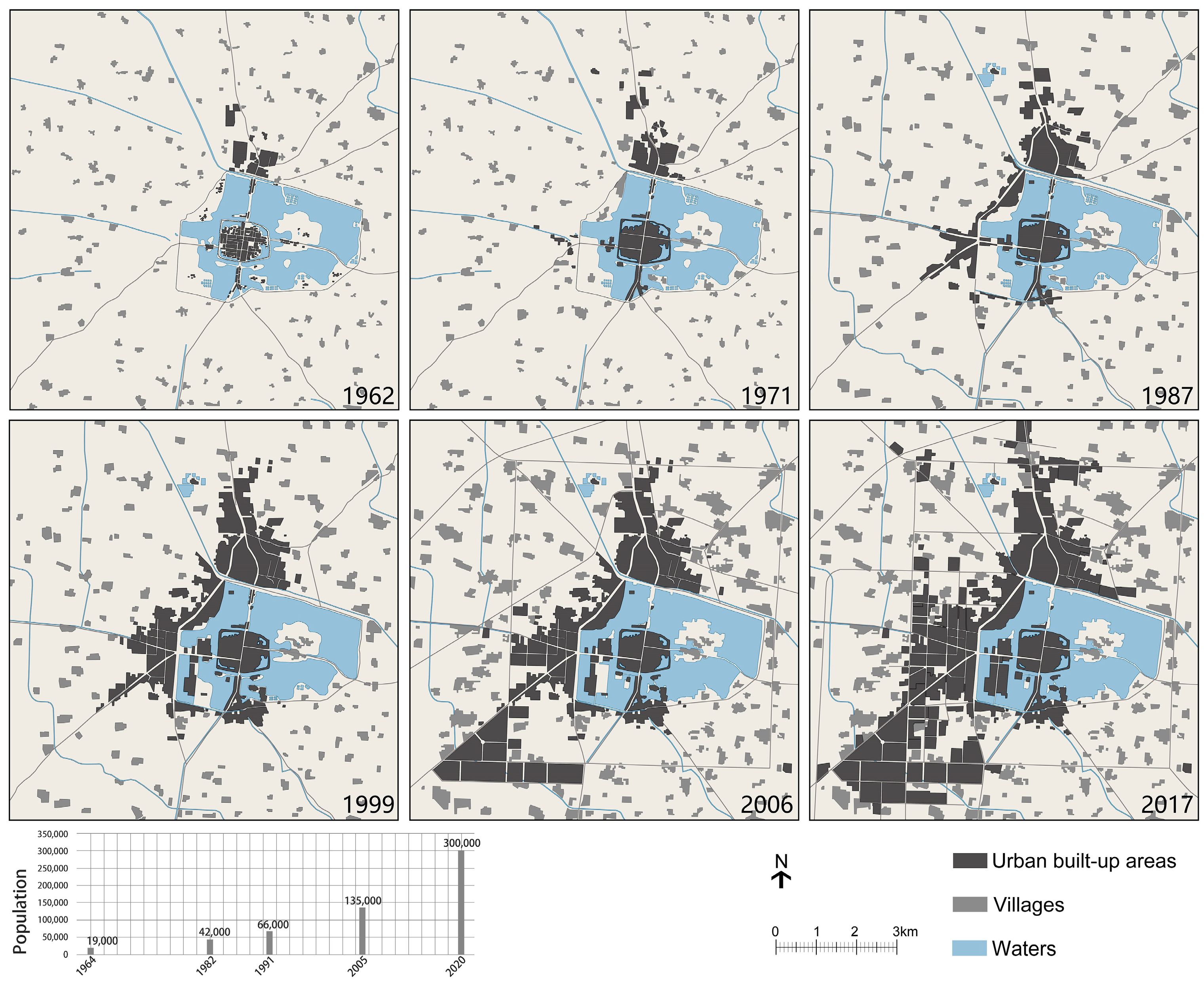
38]. The urban area expansion shown in the city maps from 1962 to 2017, and the population change during this period, reflected the urbanization process of Huaiyang city: developing steadily in the 1980s and 1990s, and accelerating in the 2000s (
Figure 7). The maps showed the western new area developing rapidly into a new city center, and the northern area outside the levee expanding. As the new urban area chose to develop on the highlands outside the levee, most of the ponds and wetlands inside the levee were preserved; only some small pits and ponds inside the former city wall (removed in 1947) were filled for new inner city construction [
19]. However, the role of ponds and wetlands changed in the new urban fabric, especially the west part of the City Lake.
Meanwhile, the city’s development strategy was also changing. Huaiyang had been viewed primarily as an agricultural service center in the past, but in the 1980s and 1990s, tourism became more prominently stated as a primary goal for urban development [
19] (pp. 205–208), [
38]. The well-known Taihao Ling Temple and the annual traditional temple fair attract visitors from across the province and beyond. Cultural relic restoration, urban beautification, and the improvement and enhancement of tourism resources became main tasks of the government.
The renovation and beautification of Willow Lake in 1996–1997 was among the first implementation projects. The works included the dredging and deepening of the lake bed, the construction of bank revetments, wharfs and recreation facilities, and the restoration of the historic Su Zhe Pavilion. In 1999–2000, Xiange Lake was dredged and revetments constructed, but in this case some areas of shallow water were filled for real estate development (a commercial complex, hotel, and residential buildings), and new fish ponds were built to offset the loss of income to local villagers. After these works, the complicated wetland bottom topography was deepened (generally to depths of 1.5 m or greater) and levelled, and revetments replaced natural shores. Without shallow water, cattail and reed communities never recovered. The fish ponds persisted only in some corners and were gradually removed in light of their effects on the lake landscape. By all the above renovations, the west part of the City Lake transformed into a more artificial lake largely for recreation and urban landscape [
19] (pp. 205–208) (
Figure 7 and
Figure 8).
From 2000, renovation of the east part of the City Lake launched. In a significant change from the western City Lake project, the concept of ecological restoration was applied to the eastern lake, with ecological restoration and recreation/tourism treated as equally important. The project involved the resettlement of villages and conversion of 0.37 km
2 of land into wetland, 0.20 km
2 of fish pond into lake, restoration of primary native vegetation and ornamentals such as 12 species of lotus, bringing in 10 million m
3 of water to the wetlands every year to compensate for the seasonal drought, and building recreation, science education, and environmental monitoring facilities [
42] (
Figure 8).
The project was also concerned about water pollution of Huaiyang’s City Lake, which was emerging in the 1970s and worsened in the early 1990s. However, starting in the 1990s, industries moved out from the inner city, and municipal sewage was collected in 2000, such that both industrial effluent and domestic sewage came under effective control. Storm water runoff and eutrophication became main factors affecting the water quality. The restoration of the eastern City Lake adopted a series of ecological measures to improve water quality, such as wetland vegetation recovery, the management and removal of wetland plant litter, and stocking filter-feeding fish like grass carp and silver carp [
42]. The eastern lake was recognized as a National Water Conservancy Scenic Area in 2014 and as a National Wetland Park in 2016.
The transformation of the ponds and lakes in Huaiyang city after the 1990s reflects the changes of their primary function from agricultural production to recreation and urban landscape beautification under the background of urbanization and tourism development. It also reflects the evolution of renovation goals from decorative scenic lakes to ecological restoration, in which restored wetlands landscapes can improve water quality among other benefits.
5. Discussion
The traditional ponds and wetlands landscapes of Huaiyang and other cities of the lower Yellow River floodplain were uniquely adapted to their climate and geography. In the context of periodic floods and droughts, the ponds and wetlands acted as a resilient buffer zone to manage floods and to regulate water levels in the low-lying floodplain cities, providing room for excess water from floods of the Yellow River and from local rains. Unlike the rigidity of conventional engineered solutions like flood defensive dikes and pumps, ponds and wetlands landscapes illustrate traditional practices to cope with environmental changes, which align better with contemporary resilient and adaptive strategies [
43,
44].
Huaiyang and other cities of the lower Yellow River floodplain illustrate social connectivity of cities with water features [
4] at two scales: that of the local scale as discussed above, and at a far larger scale, with the Yellow River itself, whose floods periodically created direct hydrologic connections and which deposited the sediment constituting the very foundation for the cities themselves, creating ponds and wetlands that resulted from the topographic evolution of the cities on the rapidly aggrading floodplain environment and inducing a series of social adaptations [
7,
8]. All these connections enhance the historical, social, and cultural values of ponds and wetlands landscapes in different dimensions.
In recent decades, traditional ponds and wetlands landscapes of Huaiyang and other cities of the lower Yellow River floodplain underwent drastic changes. While many ponds and wetlands vanished in the draining and filling caused by urbanization [
8], some were kept in the new urban context but transformed more profoundly. They were transformed into manually controlled, stable landscapes, compromising the original adaptability and resilience of ponds and wetlands landscape. For example, the current water volume control demands a high level of manual intervention, imports of water, and costs. Each year, about 10 million m
3 of water are imported to offset evaporative losses in the dry season and to maintain the water level. In the current context and mindset, seasonal drying out would not be acceptable. At the same time, during the rainy season and especially in wet years, water must be pumped out or the newly developed areas in the former low lands will likely be inundated. The adaptability of landscapes to droughts and floods has been lost.
Moreover, the current ecological restoration excluded the local communities and traditional agriculture. Almost all the villages will be relocated or transformed into urban land use, and there will be no farmland kept inside the levee [
41,
42,
45]. The traditional production practices and way of life that were so closely fitted to the environment of ponds and wetlands are being lost, reducing the diverse social connections of water with people to mere recreational activities. Meanwhile, the effect of traditional agricultural activities on maintaining ponds and wetlands landscapes as a holistic cultural–ecological system is being lost. For example, because sludge is no longer excavated for fertilizer, and cattails and weeds are no longer harvested, eutrophication must now be controlled through the deliberate removal of waterweeds every winter [
42].
These changes reflect general problems in modern landscape management: that the pursuit of efficiency and stability limits the response to changes, and excludes redundancies and multiple uses [
46]. Thus, we see that reliance on engineering measures replaces traditional local adaptive experiences, and simplified land uses of recreation and ecological restoration do not provide for the inclusion of local communities and agricultural activities. The reflection on this transformation process provides a useful perspective to review the environmental history of waterbodies in urban settings, not just rivers, but also ponds and wetlands [
47].
6. Conclusions
Ponds and wetlands, as a product of topographic evolution of the cities on the rapidly aggrading floodplain, were essential for flood and storm water retention in the low-lying city of Huaiyang. Ponds and wetlands also provided multiple ecosystem services and built close and diverse social connections with the city, creating a distinctive local cultural landscape. Providing habitats for native wetland plants, fishes, and waterfowls, ponds and wetlands constituted a dynamic and diverse natural background for human uses. Over the centuries, local people developed adaptive production activities of planting crops, harvesting wetland plants and fishing, each adapted to the localized topographic and hydrologic conditions of the wetlands and their seasonal drying and wetting cycles. The flexible approaches to deal with changes, such as adjusting planting areas with water level changes, rotating crops to cope with different flood risks occurring in different seasons, and the multiple uses of wetlands in dry seasons (e.g., collecting salt, excavating sludge, and grazing livestock), increased the resilience of local communities to drought and flood and made them more adaptable to disasters and famine than other areas. The ponds and wetlands of Huaiyang were also essential to the daily life of locals, from the uses of water and saline soils, to recreation and cultural activities. As important scenic areas celebrated in literature and art, they attracted temples, public and private gardens, and schools, relating water with residents’ spiritual world and identity.
However, the strong seasonal drying and wetting cycles of ponds and wetlands also resulted in an unstable landscape, prone to flood and drought, and often seen as low-yield, disordered, and wild. Starting in the 1970s, authorities sought to convert the ponds and wetlands to stable and high-yield agricultural landscapes. With rapid urbanization after the 1990s and increased importance of tourism, scenery and recreation became more important than agriculture. High yield is no longer a primary goal, but stability of water level and land uses are still deep-seated values for urban landscape. Ponds and wetlands were transformed into urban scenic lakes, and later a wetland park. All the renovations were dedicated to controlling water level changes with hydraulic engineering works, and eliminating flood and drought disasters. However, in the meantime, during these transformations, the diversity, adaptability, and resilience of ponds and wetlands landscapes to cope with disruptive changes of natural environments have been compromised.
Drawing upon the rich historical sources available for Huaiyang, this paper documents the historical landscapes and contemporary changes of the city’s ponds and wetlands. As better topographic data become available, similar studies could be undertaken for the ponds and wetlands landscapes of other cities in the lower Yellow River floodplain.
Today, urban storm water management, green infrastructure, and the resilient design of urban landscapes, provide new contexts and opportunities for the conservation, restoration, and regeneration of traditional ponds and wetlands landscapes. Revisiting the case history of ponds and wetlands in Huaiyang and other cities in the lower Yellow River floodplain may provide insights and inspiration for developing sustainable landscapes into the future.
Author Contributions
Conceptualization, L.Z. and G.M.K.; methodology, L.Z.; investigation, L.Z.; resources, L.Z. and G.M.K.; writing—original draft preparation, L.Z.; writing—review and editing, G.M.K. and L.Z.; supervision, G.M.K.; funding acquisition, L.Z. All authors have read and agreed to the published version of the manuscript.
Funding
This research was funded by the National Natural Science Foundation of China (No. 51608355) and the China Scholarship Council (No. 201606255081), and by the Beatrix Farrand Endowment of the Department of Landscape Architecture and Environmental Planning, UC Berkeley.
Data Availability Statement
Data used are freely available. Links can be provided upon request.
Acknowledgments
The authors benefited greatly from discussions on these topics with Professor Kongjian Yu, Peking University. We thank Jie He, Tianjin University, for processing maps and satellite images.
Conflicts of Interest
The authors declare no conflicts of interest.
References
- Austin, G. Green Infrastructure for Landscape Planning: Integrating Human and Natural Systems; Routledge: New York, NY, USA, 2014. [Google Scholar]
- Everett, G.; Lawson, E.; Lamond, J. Green infrastructure and urban water management. In Handbook on Green Infrastructure: Planning, Design and Implementation; Sinnett, D., Burgess, S., Smith, N., Eds.; Edward Elgar Publishing: Cheltenham, UK, 2015; pp. 50–66. [Google Scholar]
- Novotny, V.; Ahern, J.; Brown, P. Water Centric Sustainable Communities: Planning, Retrofitting, and Building the Next Urban Environment; John Wiley and Sons: Hoboken, NJ, USA, 2010; pp. 5–42. [Google Scholar]
- Kondolf, G.M.; Pinto, P.J. The social connectivity of urban rivers. Geomorphology 2017, 277, 182–196. [Google Scholar] [CrossRef]
- Way, T. Introduction. In River Cities, City Rivers; Way, T., Ed.; Dumbarton Oaks Research Library and Collection: Washington, DC, USA, 2018; pp. 1–12. [Google Scholar]
- Mostern, R. The Yellow River: A Natural and Unnatural History; Yale University Press: New Haven, CT, USA, 2021. [Google Scholar]
- Yu, K.; Zhang, L.; Li, D. Live with Water: Flood Adaptive Landscapes in the Yellow River Basin of China. J. Landsc. Archit. 2008, 2, 6–17. [Google Scholar] [CrossRef]
- Zhang, L. Flood Adaptive Landscapes of Cities in the Lower Yellow River Floodplain, China. In River Cities, City Rivers; Way, T., Ed.; Dumbarton Oaks Research Library and Collection: Washington, DC, USA, 2018; pp. 15–46. [Google Scholar]
- Wu, P. Huanghe Bianqian yu Kaifeng Chengshi Xingshuai Guanxi Yanjiu [Research on the Relationship between the Changes of the Yellow River and the Rise and Decline of Kaifeng City]; Kexue chubanshe: Beijing, China, 2019. [Google Scholar]
- Zou, Y. Huanghuaihai Pingyuan Lishi Dili [History Geography of the North China Plain]; Anhui Jiaoyu Chubanshe: Hefei, China, 1993. [Google Scholar]
- Qu, Y. Shiji Ducheng Kao [Studies on the Ancient Capitals in Shi Ji]; Shangwu Yinshuguan: Beijing, China, 2007. [Google Scholar]
- Cao, G. Huaiyang de Kaogu Faxian yu Yanjiu [The archaeological finds and studies of Huaiyang]. Zhongyuan Wenwu 1989, 4, 64–70. [Google Scholar]
- Xu, S. Chudu Chencheng Jiqi Lishi Dili Tanxi [Historical geography study on the capital of Chu Kingdom—Chen]. Shehui Kexue 2008, 5, 152–159. [Google Scholar]
- Chen, X. Guling Ji [Anthology of Guling]. In Wenjinge Siku Quanshu; Shangwu Yinshuguan: Beijing, China, 2005; Volume 365. [Google Scholar]
- Tang, G. Meishan Tang Xiansheng Wenji [Anthology of Mr. Tang]; Shanghai Shudian: Shanghai, China, 1986; Volume 9. [Google Scholar]
- Su, Z. Wanqiu Eryong [Two poems of Wanqiu]. In Luancheng Ji; Shanghai Guji Chubanshe: Shanghai, China, 2009; Volume 4. [Google Scholar]
- Cen, Z. Huanghe bianqian shi [Historical transformation of the Yellow River]; Zhonghua shuju: Beijing, China, 2004. [Google Scholar]
- Zhu, Z. (Ed.) Huaiyang Xianzhi [Local gazetteer of Huaiyang] (1933); Zhoukou Shi Xinwen Chubanju: Zhoukou, China, 2003. [Google Scholar]
- Li, N. (Ed.) Huaiyang Xianzhi [Local gazetteer of Huaiyang] (1988–2008); Zhongzhou Guji Chubanshe: Zhengzhou, China, 2014. [Google Scholar]
- Hu, M. (Ed.) Henan Zongzhi [Local gazetteer of Henan] (1486); National Library of China Press: Beijing, China, 2016; Volume 2–3. [Google Scholar]
- Wu, R. (Ed.) Huaining Xianzhi [Local gazetteer of Huaining] (1754); Volume 3–12.
- Liu, Z. Zhuancheng Gongchengyuan Liu Zengqi Chakan Shahe Liuyu Shangshui Huaiyang Dengxian Zaiqing Wen [Flooding disaster investigation of Shangshui, Huaiyang; et al., in Shahe watershed]. Huabei Shuili Yuekan 1931, 4, 37–39. [Google Scholar]
- Party Committee of city town of Huaiyang county. Zonghe Liyong Wanmu Chenghu Shuichan Liangshi Liannian Fengshou [Multiple Utilization of City Lake and Obtaining Series Harvests in Grain and Aquatic Products]; Huaiyang Municipal Bureau of Archives, No. 80-1-17-5; 1973.
- Huaiyang Municipal Bureau of Water Resources. Huaiyang Shuili Zhi [Hydraulic Gazetteer of Huaiyang]; 1986; App. 1; pp. 4–5.
- Huaiyang Municipal Committee for Local Gazetteer (Ed.) Huaiyang Xianzhi [Local Gazetteer of Huaiyang]; Henan Renmin Chubanshe: Zhengzhou, China, 1991. [Google Scholar]
- Life Science and Agriculture School of Zhoukou Normal College. Ecological Resources Inventory of Dragon Lake National Wetland Park of Huaiyang; 2015. [Google Scholar]
- Cui, Y. E yu wan gan diaocha zhong jianwen lu (xu) [Travels of Henan, Hubei, Anhui and Jiangxi, continued]. Nongbao 1935, 2, 1188–1189. [Google Scholar]
- Yang; (Zuozhuang Villagers, 60-year-old, Huaiyang, Henan, China); Zhang, L.; (Tianjin University, Tianjin, China); Liu, Y.; (Tianjin University, Tianjin, China); Li, Z.; (Tianjin University, Tianjin, China). Personal communication, 2015.
- Anonymous. The Book of Songs (11th BC−6th BC Century); Zhonghua Shuju: Beijing, China, 2015; pp. 271–273. [Google Scholar]
- Party committee of city town of Huaiyang county. Guanyu Jiaqiang Chenghu Yuye Fangyang Guanli de Tonggao [The Notification of Strengthening Management of the City Lake Fishery]; Huaiyang Municipal Bureau of Archives, No. 80-1-2-2; 1971; pp. 79–81.
- Li, S. Gua yantu ao xiaoyan [Collecting saline soils and making local salt]. Kaifeng Ribao 2015. 2015-11-3. [Google Scholar]
- Zhang, Q. Xiaoyan [Local salt]. Huaibin jikan 1936, 53–66. [Google Scholar]
- Su, S. Dongpo quanji [Collected works of Dongpo]. In Wenjinge Siku Quanshu; Shangwu yinshuguan: Beijing, China, 2005; Volume 370, p. 487. [Google Scholar]
- Wang, S. (Ed.) Chenzhou Zhi [Local gazetteer of Chenzhou] (1644–1661); Volume 3–10 (accessed in the Local Gazetteer Branch of National Library of China).
- Zhao, J.; Woudstra, J. In Agriculture, Learn from Dazhai”: Mao Zedong’s Revolutionary Model Village and the Battle against Nature. Landsc. Res. 2007, 32, 171–205. [Google Scholar] [CrossRef]
- People’s Government of Huaiyang County. Guanyu kaifa Jianshe Huanchenghu de Qingshi Baogao [Report on the Development and Construction of the City Lakes]; Huaiyang Municipal Bureau of Archives, No. 80-1-53-11; 1982; pp. 1–7.
- People’s Government of Huaiyang County. Guanyu chengzhen jianshe youguan wenti de baogao [Report on some issues about the urban development]; Huaiyang Municipal Bureau of Archives, No. 2-11-311; 1976; pp. 48–51, (Accessible in the Municipal Archives with the archive number provided here).
- People’s Government of Huaiyang County. Huaiyang Xiancheng Zongti Guihua Shuomingshu [Statement of the Huaiyang City Master Plan] (1982–2000); Huaiyang Municipal Bureau of Archives, No. 2-13-395-10; 1982; pp. 19–44, (Accessible in the Municipal Archives with the archive number provided here).
- People’s Government of Huaiyang County. Guanyu Woxian Disanci Renkou Pucha Zhuyao Shuzi de Tongbao [Notice on the Main Figures of the Third Census in Our County]; Huaiyang Municipal Bureau of Archives, No. 2-13-390-5; 1982; pp. 34–36, (Accessible in the Municipal Archives with the archive number provided here).
- People’s Government of Huaiyang County. Huaiyang Xian Chengshi Zongti guihua [Huaiyang City Master Plan] (2007–2020); 2007.
- People’s Government of Huaiyang County. Huaiyang Xian Chengshi Zongti Guihua [Huaiyang City Master Plan] (2016–2035); 2020.
- People’s Government of Huaiyang County. Huaiyang Longhu Guojia Shidi Gongyuan Jianshe Jishi [Construction Report of Huaiyang Long Lake National Wetland Park]; 2015.
- Resilient Design: Flooding. Available online: https://www.asla.org/flooding.aspx (accessed on 11 December 2019).
- Jha, A.K.; Bloch, R.; Lamond, J. Cities and Flooding: A Guide to Integrated Urban Flood Risk Management for the 21st Century; The World Bank: Washington, DC, USA, 2012. [Google Scholar]
- Huaiyang Municipal Bureau of Housing and Urban-Rural Development. Xihuang Gudu Fengjing Mingshengqu Zhongxin Jingqu Chengshi Sheji yu Kongzhixing xiangxi GUIHUA [Urban Design and Regulatory Plan of the Central Area of Huaiyang Old City Scenic Area]; 2013.
- Walker, B.; Salt, D. Resilience thinking: Sustaining Ecosystems and People in a Changing World; Island Press: Washington, DC, USA, 2006. [Google Scholar]
- Castonguay, S.; Evenden, M. Urban Rivers: Remaking Rivers, Cities, and Space in Europe and North America; University of Pittsburgh Press: Pittsburgh, PA, USA, 2012. [Google Scholar]
| Disclaimer/Publisher’s Note: The statements, opinions and data contained in all publications are solely those of the individual author(s) and contributor(s) and not of MDPI and/or the editor(s). MDPI and/or the editor(s) disclaim responsibility for any injury to people or property resulting from any ideas, methods, instructions or products referred to in the content. |
© 2024 by the authors. Licensee MDPI, Basel, Switzerland. This article is an open access article distributed under the terms and conditions of the Creative Commons Attribution (CC BY) license (https://creativecommons.org/licenses/by/4.0/).


