Assessment of Sediments’ Transport Triggering Processes through the Identification of Deposition Shapes in Large Reservoirs
Abstract
:1. Introduction
2. Materials and Methods
2.1. Study Area
2.2. Methods
- Mathematical modeling: 1D and 2D numerical model simulations can be employed to forecast the long-term sediment deposition patterns in reservoirs. The long-term sediment deposition of a reservoir can be estimated using the one- or two-dimensional numerical modeling approach. Both approaches can be developed through RESSASS (1D) and IBER software, respectively (2D) [45,46].
- 2.
- Bathymetric and topographic approach: This was the selected method for this research. This method uses acoustic signals and geolocation technologies to reproduce the underwater topography [31,55]. In this research, the equipment used was an Applanix SurfMaster GNSS/INS GPS integrated system with two GPS TRIMBLE antennas. This mobile equipment provides coordinates to the Hypack2021 navigation system for the correct positioning of the data acquired by the multibeam system. Bathymetry was carried out with a multibeam system (NORBIT iWBMSe), planning parallel lines as far as possible, overlapping by 20%, to ensure 100% coverage of the surveyed area. Data acquisition was carried out at 400 kHz, with a sampling frequency of 512 beams every 10–20 Hz. Bathymetric data acquisition was carried out on 5 June 2023. The acquisition and recording system were a computer equipped with digital data acquisition with georeferencing of the information. The software used for data collection and processing was the Hypack-Hysweep software. During the bathymetric survey, 96 lines totaling 45 km were traversed (Figure 2).
- 3.
- Core chronology: This is a traditional technique used to measure sediment deposition with high temporal resolution over periods of up to 100–150 years [20,30,56]. This method involves a huge spectrum of techniques developed in the field for data sediments. This is crucial for estimating the impact of climate change with a sufficient temporal perspective.
- 4.
- Hydrological calculation: Hydrological data are used in mathematical formulae to calculate sedimentation and trap efficiency. Here, equations and models are selected according to the type, quality, and frequency of the data available [11,57]. For this method, the detailed characterization of normal and extreme hydrological events is crucial. Furthermore, there is an emerging research line in predictive hydrology based on the dependence study of hydrological events [4,20,21,22].
- 5.
- Satellite imaging and remote sensing techniques have been proposed as alternative methods to monitor sedimentation [31,58]. The support of services on Earth observation equipment like Copernicus (component of the European Union’s Space programme) is crucial for capturing the dynamics and real-time temporal evolution of the sediment silting phenomenon.
2.3. Research Concept
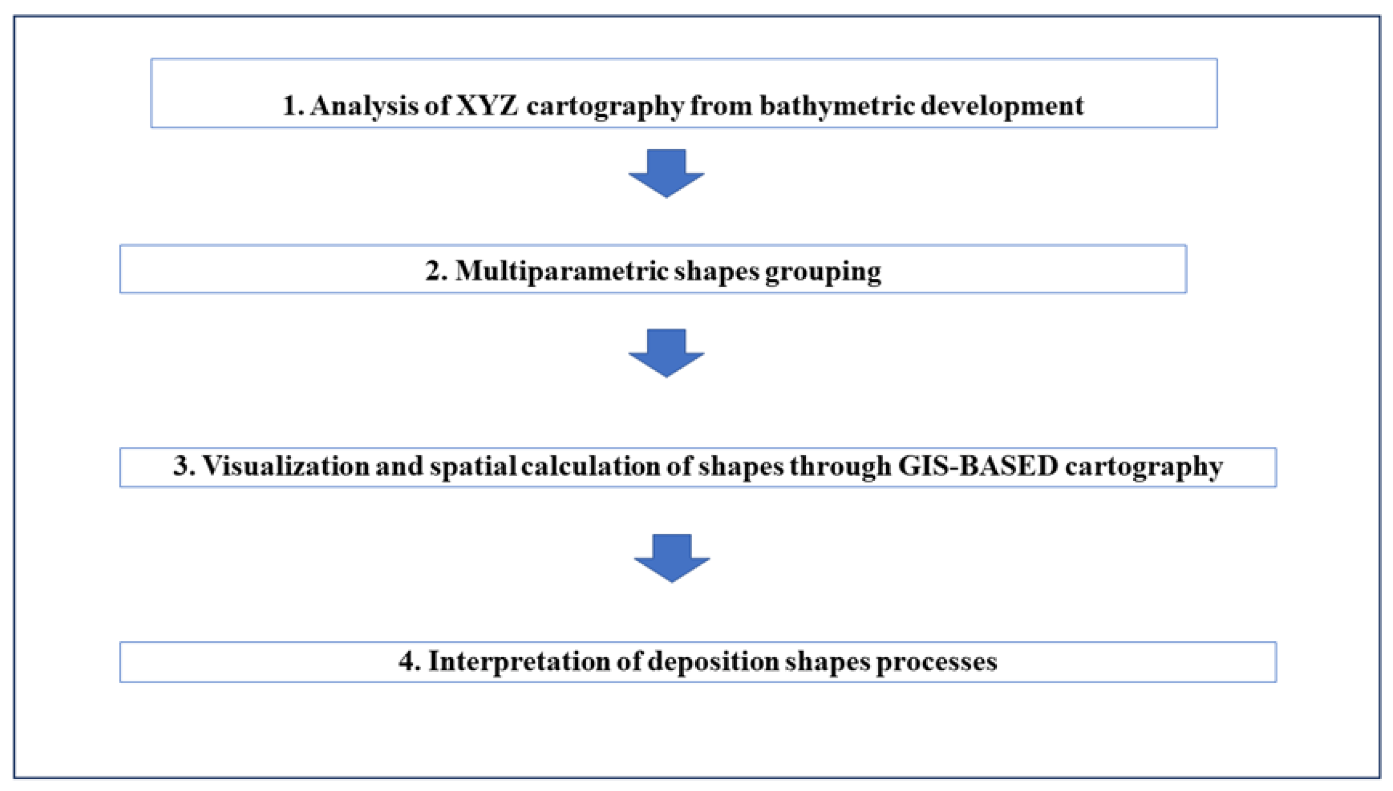
- Analysis of XYZ cartography from bathymetric development (Figure 4). The first step comprised a detailed analysis of the reconstruction of a bathymetric and topographic model obtained from the aforementioned method. This analysis comprised different aspects such as the location of vertical jumps, flat areas, breaking lines, slope at different areas and general slope, identification of dynamic sediment curves, and geometry of the sediment breakthrough front, among others.
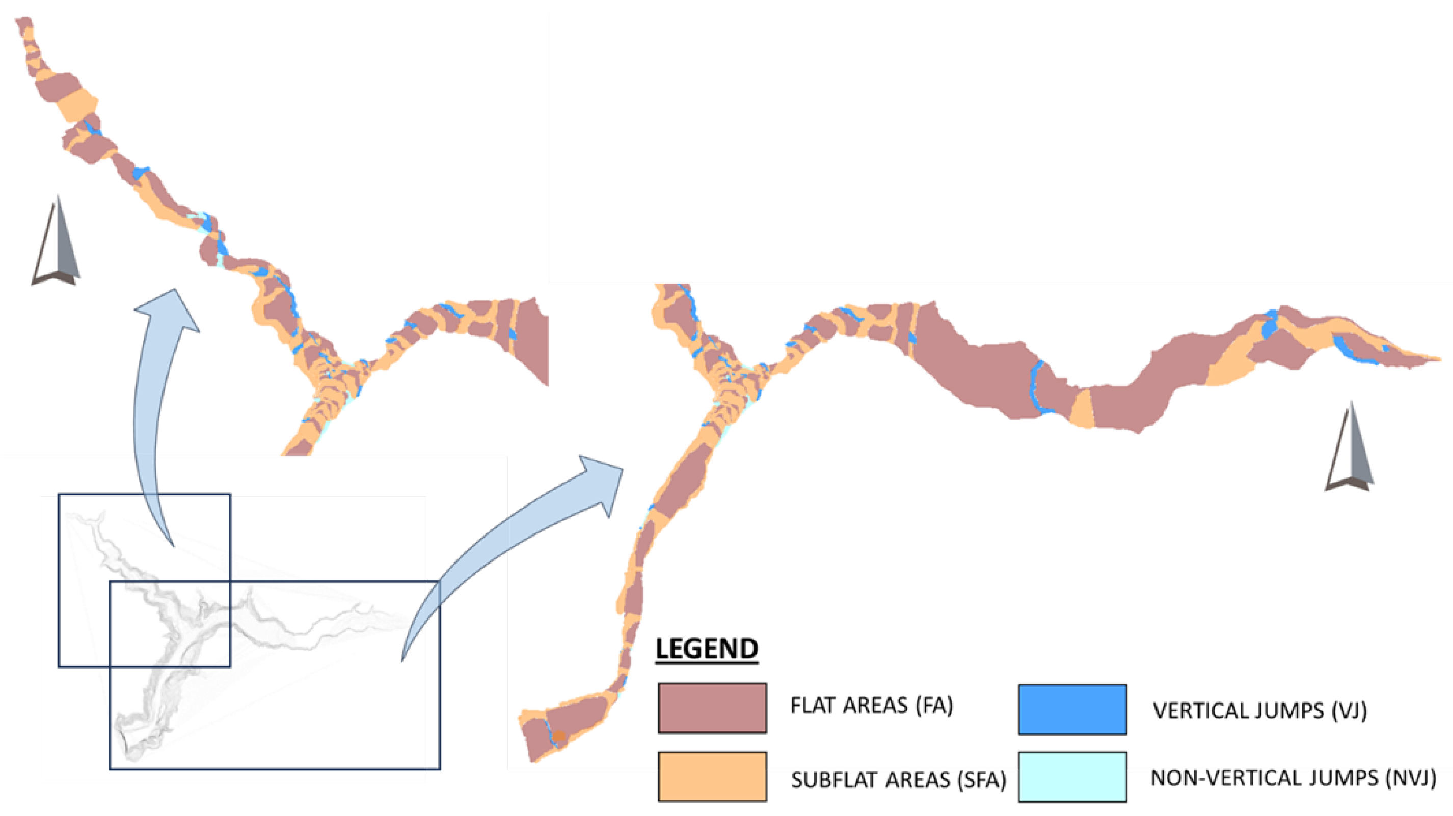
- Multiparametric shapes identification. Based on the pervious analysis, six categories of shapes were identified based on four parameters, listed as follows: slope continuity, slope break, absolute and relative slope, and arc configuration. The established thresholds and ranges for the slope are described as follows: 0 (Flat); 0–1.16 (SubFlat); 1.16–2.5 (Non-Vertical Jump); >2.5 (Vertical Jump). Furthermore, BLs were established for each change of shape.
- 3.
- Visualization and spatial calculation of shapes through GIS-based cartography. Mapping digitalization was conducted to spatially characterize the different shapes of sediments deposition (please see Figure 6).
- 4.
- Interpretation of deposition shapes processes. For this, a double-stage analysis was developed. First, an analysis based on transport processes was realized for reaching the second phase (multiparametric shapes identification). This comprised an analysis of deposition processes that lead to the previously identified shapes. The second stage complemented the previous study by developing an analysis of the dam influence on fluvial hydrodynamics and sediments transport.
2.4. Geological Context and Main Landslides
3. Results
3.1. Results Type
3.2. Physical Interpretation of Shapes
- Arc-Lines (dual changing upstream–downstream convexity): They are produced by slope friction, which involves a sediment deposition due to differential decrease in flow velocity. On one hand, convexity towards downstream that occurs at the reservoir tail shows a strong equivalence to the velocity profile in plants that usually follows a parabolic function (Figure 7). On the other hand, convexity towards upstream may be caused by the dam in the form of inverse flow and sediments’ transport process return. There is a change in string dimension between upstream and downstream AL due to return wave attenuation, flow velocity, and channel size. Consequently, the higher the flow velocity, the smaller the string cord that is produced. There is also a river stretch where the convexity of AL is not well defined, and it is quite uncertain (Figure 7). This is produced between the Ízbor junction and the reservoir tail on Guadalfeo River.
- Breaking Lines: Lines marking the planes of high slope change.
- Flat Areas: In times of stationary regime, finer materials form flat plateaus, close to the dam, due to the prevailing hydrostatic conditions.
- Subflat Areas: When sediments are remobilized due to changing circumstances, especially a change in hydrodynamic conditions, a gentle slope gradient towards the dam is produced.
- Vertical Jumps: These are produced predominantly in episodes of high sediment mobilization due to high flows and abrupt braking. A flood is produced in the entire section of the wadi and when the wavefront suddenly ceases to produce an effect, the process is paralyzed homogeneously throughout the section. Another reason may be the previous existence of natural or artificial promontories that act as a dam for the sediments.
- Non-Vertical Jumps: These are produced when the vertical jumps are remobilized due to a change in hydrodynamic conditions. A steep gradient towards the dam is produced.
4. Discussion
5. Conclusions
Author Contributions
Funding
Data Availability Statement
Acknowledgments
Conflicts of Interest
References
- Borland, D.C. Cap. 9 River Mechanics. In Reservoir Sedimentation; Shen, H.W., Ed.; Water Resources Publication: Fort Collins, CO, USA, 1971. [Google Scholar]
- Petkovsek, G.; Roca, M. Impact of reservoir operation on sediment deposition. In Proceedings of the Institution of Civil Engineers-Water Management; Thomas Telford Ltd.: London, UK, 2014; Volume 167, Issue 10, pp. 577–584. [Google Scholar]
- Gao, Q.; Li, Y.; Cheng, Q.; Yu, M.; Hu, B.; Wang, Z.; Yu, Z. Analysis and assessment of the nutrients, biochemical indexes and heavy metals in the Three Gorges Reservoir, China, from 2008 to 2013. Water Res. 2016, 92, 262–274. [Google Scholar] [CrossRef]
- Xu, M.; Dong, X.; Yang, X.; Chen, X.; Zhang, Q.; Liu, Q.; Jeppesen, E. Recent sedimentation rates of shallow lakes in the middle and lower reaches of the Yangtze River: Patterns, controlling factors and implications for lake management. Water 2017, 9, 617. [Google Scholar] [CrossRef]
- Schleiss, A.J.; Franca, M.J.; Juez, C.; De Cesare, G. Reservoir sedimentation. J. Hydraul. Res. 2016, 54, 595–614. [Google Scholar] [CrossRef]
- Ran, L.; Lu, X.X.; Xin, Z.; Yang, X. Cumulative sediment trapping by reservoirs in large river basins: A case study of the Yellow River basin. Glob. Planet. Chang. 2013, 100, 308–319. [Google Scholar] [CrossRef]
- Kokpinar, M.A.; Altan-Sakarya, A.B.; Kumcu, S.Y.; Gogus, M. Assessment of sediment yield estimations for large watershed areas: A case study for the Seyhan, Demirköprü and Hirfanlı reservoirs in Turkey. Hydrol. Sci. J. 2015, 60, 2189–2203. [Google Scholar] [CrossRef]
- Rahmani, V.; Kastens, J.H.; DeNoyelles, F.; Jakubauskas, M.E.; Martinko, E.A.; Huggins, D.H.; Gnau, C.; Liechti, P.M.; Campbell, S.W.; Callihan, R.A.; et al. Examining storage capacity loss and sedimentation rate of large reservoirs in the central US Great Plains. Water 2018, 10, 190. [Google Scholar] [CrossRef]
- González Rodríguez, L.; McCallum, A.; Kent, D.; Rathnayaka, C.; Fairweather, H. A review of sedimentation rates in freshwater reservoirs: Recent changes and causative factors. Aquat. Sci. 2023, 85, 60. [Google Scholar] [CrossRef]
- Molina, J.L.; Martos-Rosillo, S.; Martín-Montañés, C.; Pierce, S. The social sustainable aquifer yield: An indicator for the analysis and assessment of the integrated aquifers management. Water Resour. Manag. 2012, 26, 2951–2971. [Google Scholar] [CrossRef]
- Morris, G.; Fan, J. Reservoirs Sedimentation Handbook: Design and Management of Dams, Reservoirs and Watersheds for Sustainable Us; McGraw Hill: New York, NY, USA, 2010. [Google Scholar]
- Wang, G.; Wu, B.; Wang, Z.Y. Sedimentation problems and management strategies of Sanmenxia reservoir, Yellow river, China. Water Resour. Res. 2005, 41, W09417. [Google Scholar] [CrossRef]
- Reiser, D.W.; Ramey, M.P.; Wesche, T.A. Flushing flows. In Alternatives in Regulated River Management; CRC Press: Boca Raton, FL, USA, 2018. [Google Scholar]
- Doretto, A.; Bo, T.; Bona, F.; Apostolo, M.; Bonetto, D.; Fenoglio, S. Effectiveness of artificial floods for benthic community recovery after sediment flushing from a dam. Environ. Monit. Assess. 2019, 191, 88. [Google Scholar] [CrossRef]
- Patmont, C.; LaRosa, P.; Narayanan, R.; Forrest, C. Environmental dredging residual generation and management. Integr. Environ. Assess. Manag. 2018, 14, 335–343. [Google Scholar] [CrossRef] [PubMed]
- White, R. Evacuation of Sediments from Reservoirs; Thomas Telford: London, UK, 2001. [Google Scholar]
- Isaac, N.; Eldho, T.I. Sediment management studies of a run-of-the-river hydroelectric project using numerical and physical model simulations. Int. J. River Basin Manag. 2016, 14, 165–175. [Google Scholar] [CrossRef]
- Chaudhary, H.P.; Isaac, N.; Tayade, S.B.; Bhosekar, V.V. Integrated 1D and 2D numerical model simulations for flushing of sediment from reservoirs. ISH J. Hydraul. Eng. 2019, 25, 19–27. [Google Scholar] [CrossRef]
- Lai, Y.G.; Huang, J. Sediment modeling of hydraulic flushing: General guidelines, SEDHYD-2023. In Proceedings of the Sedimentation and Hydrologic Modeling Conference, St. Louis, MO, USA, 8–12 May 2023. [Google Scholar]
- Franco, A.; Moernaut, J.; Schneider-Muntau, B.; Strasser, M.; Gems, B. The 1958 Lituya Bay tsunami—Pre-event bathymetry reconstruction and 3D numerical modelling utilising the computational fluid dynamics software Flow-3D. Nat. Hazards Earth Syst. Sci. 2020, 20, 2255–2279. [Google Scholar] [CrossRef]
- Rose, N.L.; Morley, D.; Appleby, P.G.; Battarbee, R.W.; Alliksaar, T.; Guilizzoni, P.; Punning, J.M. Sediment accumulation rates in European lakes since AD 1850: Trends, reference conditions and exceedence. J. Paleolimnol. 2011, 45, 447–468. [Google Scholar] [CrossRef]
- Schiefer, E.; Petticrew, E.L.; Immell, R.; Hassan, M.A.; Sonderegger, D.L. Land use and climate change impacts on lake sedimentation rates in western Canada. Anthropocene 2013, 3, 61–71. [Google Scholar] [CrossRef]
- Zhao, Y.; Cao, W.; Hu, C.; Wang, Y.; Wang, Z.; Zhang, X.; Zhu, B.; Cheng, C.; Yin, X.; Liu, B.; et al. Analysis of changes in characteristics of flood and sediment yield in typical basins of the Yellow River under extreme rainfall events. Catena 2019, 177, 31–40. [Google Scholar] [CrossRef]
- Ahn, Y.S. Recent changes in sedimentation rate in three lakes of Ishikari Wetland, Northern Japan determined by 210Pb dating. Water Resour. 2018, 45, 795–802. [Google Scholar] [CrossRef]
- Pope, I.C.; Odhiambo, B.K. Soil erosion and sediment fluxes analysis: A watershed study of the Ni Reservoir, Spotsylvania County, VA, USA. Environ. Monit. Assess. 2013, 186, 1719–1733. [Google Scholar] [CrossRef]
- McCall, P.; Robbins, J.; Matisoff, G.J.C.G. 137Cs and 210Pb transport and geochronologies in urbanized reservoirs with rapidly increasing sedimentation rates. Chem. Geol. 1984, 44, 33–65. [Google Scholar] [CrossRef]
- Ruiz-Fernandez, A.; Paez-Osuna, F.; Urrutia-Fucugauchi, J.; Preda, M.J.C. 210Pb geochronology of sediment accumulation rates in Mexico City Metropolitan Zone as recorded at Espejo de los Lirios lake sediments. Catena 2005, 61, 3–48. [Google Scholar] [CrossRef]
- Daramola, J.; Adepehin, E.J.; Ekhwan, T.M.; Choy, L.K.; Mokhtar, J.; Tabiti, T.S. Impacts of land-use change, associated land-use area and runoff on watershed sediment yield: Implications from the Kaduna Watershed. Water 2022, 14, 325. [Google Scholar] [CrossRef]
- Nguyen, T.X.; Nguyen, B.T.; Tran, H.T.T.; Le, T.T.; Trinh, T.T.; Trinh, T.T.; Tu, M.B.; Cao, N.D.T.; Vo, H.D.T. The interactive effect of the season and estuary position on the concentration of persistent organic pollutants in water and sediment from the Cua Dai estuary in Vietnam. Environ. Sci. Pollut. Res. 2019, 26, 10756–10766. [Google Scholar] [CrossRef] [PubMed]
- Shrestha, B.; Maskey, S.; Babel, M.S.; van Griensven, A.; Uhlenbrook, S.J.C.C. Sediment related impacts of climate change and reservoir development in the Lower Mekong River Basin: A case study of the Nam Ou Basin, Lao PDR. Clim. Chang. 2018, 149, 13–27. [Google Scholar] [CrossRef]
- Chen, X.; Qiao, Q.; McGowan, S.; Zeng, L.; Stevenson, M.A.; Xu, L.; Huang, C.; Liang, J.; Cao, Y. Determination of geochronology and sedimentation rates of shallow lakes in the middle Yangtze reaches using 210Pb, 137Cs and spheroidal carbonaceous particles. Catena 2019, 174, 546–556. [Google Scholar] [CrossRef]
- Darama, Y.; Selek, Z.; Slek, B.; Ajgul, M.A.; Dagdeviren, M. Determination of sediment deposition of Hasanlar Dam using bathymetric and remote sensing studies. Nat. Hazards 2019, 97, 211–227. [Google Scholar] [CrossRef]
- Navas, A.; Valero-Garces, B.; Gaspar, L.; Machin, J. Reconstructing the history of sediment accumulation in the Yesa reservoir: An approach for management of mountain reservoirs. Lake Reserv. Manag. 2009, 25, 15–27. [Google Scholar] [CrossRef]
- Auel, C.; Albayrak, I.; Sumi, T.; Boes, R.M. Sediment transport in high-speed flows over a fixed bed: 1. Particle dynamics. Earth Surf. Process. Landf. 2017, 42, 1365–1383. [Google Scholar] [CrossRef]
- Serra-Llobet, A.; Kondolf, G.M.; Magdaleno, F.; Keenan-Jones, D. Flood diversions and bypasses: Benefits and challenges. WIREs Water 2022, 9, e1562. [Google Scholar] [CrossRef]
- Nilawar, A.P.; Waikar, M.L. Impacts of climate change on streamflow and sediment concentration under RCP 4.5 and 8.5: A case study in Purna river basin, India. Sci. Total Environ. 2019, 650, 2685–2696. [Google Scholar] [CrossRef]
- Wischmeier, W.H.; Smith, D.D. Predicting rainfall erosion losses. In USDA Agr. Res. Serv. Handbook, no. 537; USDA: Washington, DC, USA, 1978. [Google Scholar]
- Bouyoucos, G.J. The clay ratio as a criterion of susceptibility of soils to erosion. Agron. J. 1935, 27, 738–741. [Google Scholar] [CrossRef]
- MITECO. Ministerio para la Transformación Ecológica y el Reto Demográfico. Available online: https://www.miteco.gob.es/es/biodiversidad/servicios/banco-datos-naturaleza/informacion-disponible/inventario_nacional_erosion.html (accessed on 10 January 2024).
- Pudasaini, S.P.; Miller, S.A. The hypermobility of huge landslides and avalanches. Eng. Geol. 2013, 157, 124–132. [Google Scholar] [CrossRef]
- Yenes, M.; Monterrubio, S.; Nespereira, J.; Santos, G.; Fernández-Macarro, B. Large landslides induced by fluvial incision in the Cenozoic Duero Basin (Spain). Geomorphology 2015, 246, 263–276. [Google Scholar] [CrossRef]
- Franco, A.; Moernaut, J.; Schneider-Muntau, B.; Strasser, M.; Gems, B. Triggers and consequences of landslide-induced impulse waves—3D dynamic reconstruction of the Taan Fiord 2015 tsunami event. Eng. Geol. 2021, 294, 106384. [Google Scholar] [CrossRef]
- Panizzo, A.; De Girolamo, P.; Di Risio, M.; Maistri, A.; Petaccia, A. Great landslide events in Italian artificial reservoirs. Nat. Hazards Earth Syst. Sci. 2005, 5, 733–740. [Google Scholar] [CrossRef]
- SAIH-HIDROSUR. Available online: http://www.redhidrosurmedioambiente.es/saih/mapa/tiempo/real (accessed on 30 January 2024).
- Bladé, E.; Cea, L.; Corestein, G.; Escolano, E.; Puertas, J.; Vázquez-Cendón, E.; Dolz, J.; Coll, A. Iber-River modelling simulation tool. Rev. Int. Métodos Numéricos Para Cálculo Y Diseño Ing. 2014, 30, 1–10. [Google Scholar] [CrossRef]
- Wallingford, H.R. Measuring and Predicting Reservoir Volume Changes due to Sedimentation; User manual for RESSASS Version 1.5; HR Wallingford: Oxon, UK, 2001. [Google Scholar]
- Westrich, B.; Juraschek, M. Flow transport capacity for suspended sediment. In Proceedings of the 21st Congress IAHR, Melbourne, Australia, 19–23 August 1985. [Google Scholar]
- Ackers, P.; White, W.R. Sediment transport: New approach and analysis. J. Hydraul. Div. 1973, 99, 2041–2060. [Google Scholar] [CrossRef]
- Ali, M.; Sterk, G. Evaluation of sediment management strategies on reservoir storage depletion rate: A case study. Doboku Gakkai Ronbunshuu B 2010, 66, 207–216. [Google Scholar] [CrossRef]
- Lara, J.M.; Pemberton, E.L. Initial unit weight of deposited sediments. In Proceedings of the Federal Interagency Sedimentation Conference, Jackson, MI, USA, 28 January–1 February 1963; U.S. Dept. of Agriculture, Miscellaneous Publication No. 970. USDA: Washington, DC, USA, 1963; pp. 818–845. [Google Scholar]
- Cea, L.; Bladé, E. A simple and efficient unstructured finite volume scheme for solving the shallow water equations in overland flow applications. Water Resour. Res. 2015, 51, 5464–5486. [Google Scholar] [CrossRef]
- Roe, P.L. Discrete models for the numerical analysis of time-dependent multidimensional gas dynamics. In Upwind and High-Resolution Schemes; Springer: Berlin/Heidelberg, Germany, 1986; pp. 451–469. [Google Scholar]
- Hirano, M. River-bed degradation with armoring. In Proceedings of the Japan Society of Civil Engineers; Japan Society of Civil Engineers: Tokyo, Japan, 1971; Volume 1971, pp. 55–65. [Google Scholar]
- Sanz Ramos, M.; Cea Gómez, L.; Bladé i Castellet, E.; López Gómez, D.; Sañudo Costoya, E.; Corestein Poupeau, G.; Aragón Hernández, J.L. Iber v3: Manual de Referencia e Interfaz de Usuario de las Nuevas Implementaciones; International Centre for Numerical Methods in Engineering (CIMNE): Catalonia, Spain, 2022. [Google Scholar]
- Banasik, K.; Hejduk, L.; Krajewski, A.; Wasilewich, M. The intensity of siltation of a small reservoir in Poland and its relationship to environmental changes. Catena 2021, 204, 105436. [Google Scholar] [CrossRef]
- Xiang, L.; Lu, X.X.; Higgitt, D.L.; Wang, S.M. Recent lake sedimentation in the middle and lower Yangtze basin inferred from Cs-137and Pb-210 measurements. J. Asian Earth Sci. 2002, 21, 77–86. [Google Scholar] [CrossRef]
- Lemma, H.; Frankl, A.; Dessie, M.; Poesen, J.; Adgo, E.; Nyssen, J. Consolidated sediment budget of Lake Tana, Ethiopia (2012–2016). Geomorphology 2020, 371, 107434. [Google Scholar] [CrossRef]
- Mbatya, W.; Qayoom, L.A.T.; Sempewo, J.I. Assessment of reservoir sedimentation level and storage capacity using remotely sensed data for Namadope Reservoir in Luuka District, Uganda. In World Environmental and Water Resources Congress; American Society of Civil Engineers: Reston, VA, USA, 2019; pp. 30–42. [Google Scholar]
- Marín Lechado, C.; Roldán García, F.J.; Pineda Velasco, A.; Martínez Zubieta, P.; Rodero Pérez, J.; Díaz Pinto, G. Mapa Geológico Digital Continuo E. 1:50.000, Zonas Internas de las Cordilleras Béticas (Zona-2100). Available online: http://info.igme.es/cartografiadigital/geologica/geodezona.aspx?Id=Z2100 (accessed on 30 November 2023).
- Fernández, T.; Brabb, E.E.; Salazar, F.D.; Martin-Algarra, A.; Irigary, C.F.; Estevez, A.R.; Chacon, J. Rasgos geológicos y movimientos de ladera en el sector Izbor-Velez Benaudalla de la cuenca del Rio Guadalfeo (Granada). In Proceedings of the IV Simposio Nacional Sobre Taludes y Laderas Inestables (795–808), Granada, Spain, 11–14 November 1997. [Google Scholar]
- Jiménez, J.; Irigaray, C.; El Hamdouni, R.; Fernández del Castillo, T.; Chacón, J. Rasgos geomorfológicos y movimientos de ladera en la cuenca alta del Río Guadalfeo. In VI Simposio Nacional Sobre Taludes y Laderas Inestables; Corominas, J., Alonso, E., Ruiz, M.R., Ziegler, M.H., Eds.; Editorial Universitat Politècnica de València: Valencia, Spain, 2005; pp. 891–902. [Google Scholar]
- Chacón, J.; Irigaray, T.; Fernández, T. Los movimientos de ladera de la provincia de Granada. In Atlas Riesgos Naturales en la Provincia de Granada, 1st ed.; Ferrer, M., Ed.; Diputación de Granada-Geological Survey of Spain (IGME): Valencia, Spain, 2007; pp. 45–82. [Google Scholar]
- Reyes-Carmona, C.; Barra, A.; Galve, J.P.; Monserrat, O.; Pérez-Peña, J.V.; Mateos, R.M.; Notti, D.; Ruano, P.; Millares, A.; López-Vinielles, J.; et al. Sentinel-1 DInSAR for monitoring active landslides in critical infrastructures: The case of the Rules reservoir (Southern Spain). Remote Sens. 2020, 12, 809. [Google Scholar] [CrossRef]
- Reyes-Carmona, C.; Galve, J.P.; Moreno-Sánchez, M.; Riquelme, A.; Ruano, P.; Millares, A.; Teixidó, T.; Sarro, R.; Pérez-Peña, J.V.; Barra, A.; et al. Rapid characterisation of the extremely large landslide threatening the Rules reservoir (Southern Spain). Landslides 2021, 18, 3781–3798. [Google Scholar] [CrossRef]
- Irigaray, C.; Lamas, F.; El Hamdouni, R.; Fernández, T.; Chacón, J. The importance of the precipitation and the susceptibility of the slopes for the triggering of landslides along the roads. Nat. Hazards 2000, 21, 65–81. [Google Scholar] [CrossRef]


| Shape Type | Surface (km2)/Length (m) | % Surface/Length |
|---|---|---|
| Flat Areas | 0.86 | 53.8 |
| Subflat Areas | 0.67 | 41.8 |
| Non-Vertical Jumps | 0.01 | 0.80 |
| Vertical Jumps | 0.06 | 3.60 |
| Breaking Lines | 567.6 | 58.9 |
| Arc-Lines | 396.6 | 41.1 |
Disclaimer/Publisher’s Note: The statements, opinions and data contained in all publications are solely those of the individual author(s) and contributor(s) and not of MDPI and/or the editor(s). MDPI and/or the editor(s) disclaim responsibility for any injury to people or property resulting from any ideas, methods, instructions or products referred to in the content. |
© 2024 by the authors. Licensee MDPI, Basel, Switzerland. This article is an open access article distributed under the terms and conditions of the Creative Commons Attribution (CC BY) license (https://creativecommons.org/licenses/by/4.0/).
Share and Cite
Molina, J.-L.; Espejo, F.; Zazo, S.; Diez-Castro, T.; Mongil-Manso, J.; Nespereira, J.; Patino-Alonso, C.; Silla, F. Assessment of Sediments’ Transport Triggering Processes through the Identification of Deposition Shapes in Large Reservoirs. Water 2024, 16, 960. https://doi.org/10.3390/w16070960
Molina J-L, Espejo F, Zazo S, Diez-Castro T, Mongil-Manso J, Nespereira J, Patino-Alonso C, Silla F. Assessment of Sediments’ Transport Triggering Processes through the Identification of Deposition Shapes in Large Reservoirs. Water. 2024; 16(7):960. https://doi.org/10.3390/w16070960
Chicago/Turabian StyleMolina, José-Luis, Fernando Espejo, Santiago Zazo, Teresa Diez-Castro, Jorge Mongil-Manso, José Nespereira, Carmen Patino-Alonso, and Fernando Silla. 2024. "Assessment of Sediments’ Transport Triggering Processes through the Identification of Deposition Shapes in Large Reservoirs" Water 16, no. 7: 960. https://doi.org/10.3390/w16070960
APA StyleMolina, J.-L., Espejo, F., Zazo, S., Diez-Castro, T., Mongil-Manso, J., Nespereira, J., Patino-Alonso, C., & Silla, F. (2024). Assessment of Sediments’ Transport Triggering Processes through the Identification of Deposition Shapes in Large Reservoirs. Water, 16(7), 960. https://doi.org/10.3390/w16070960


