
Evaluation of the Artificial Neural Networks—Dynamic Infrared Rain Rate near Real-Time (PDIR-Now) Satellite’s Ability to Monitor Annual Maximum Daily Precipitation in Mainland China


Abstract
:1. Introduction
2. Materials and Methods
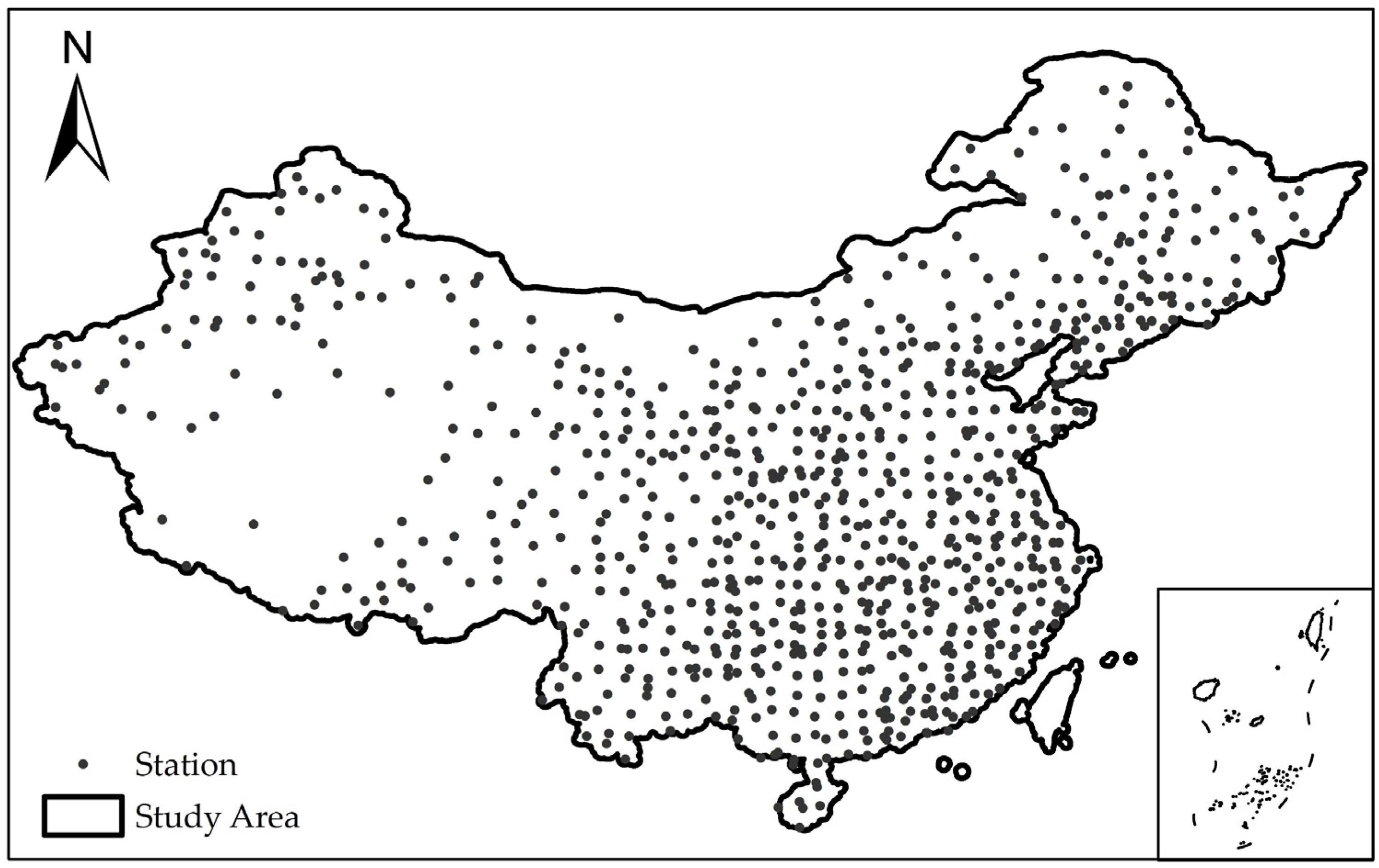
2.1. Study Area
2.2. Data Sources
2.2.1. Station Data
2.2.2. PDIR-Now Satellite Product Data
2.3. Performance Evaluation Methods
- (1)
- Correlation Coefficient (R)
- (2)
- Root Mean Square Error (RMSE)
- (3)
- Relative Root Mean Square Error (RRMSE)
- (4)
- Relative Bias (RB)
3. Results
3.1. Spatial Distribution Characteristics of Satellite-Inferred Precipitation
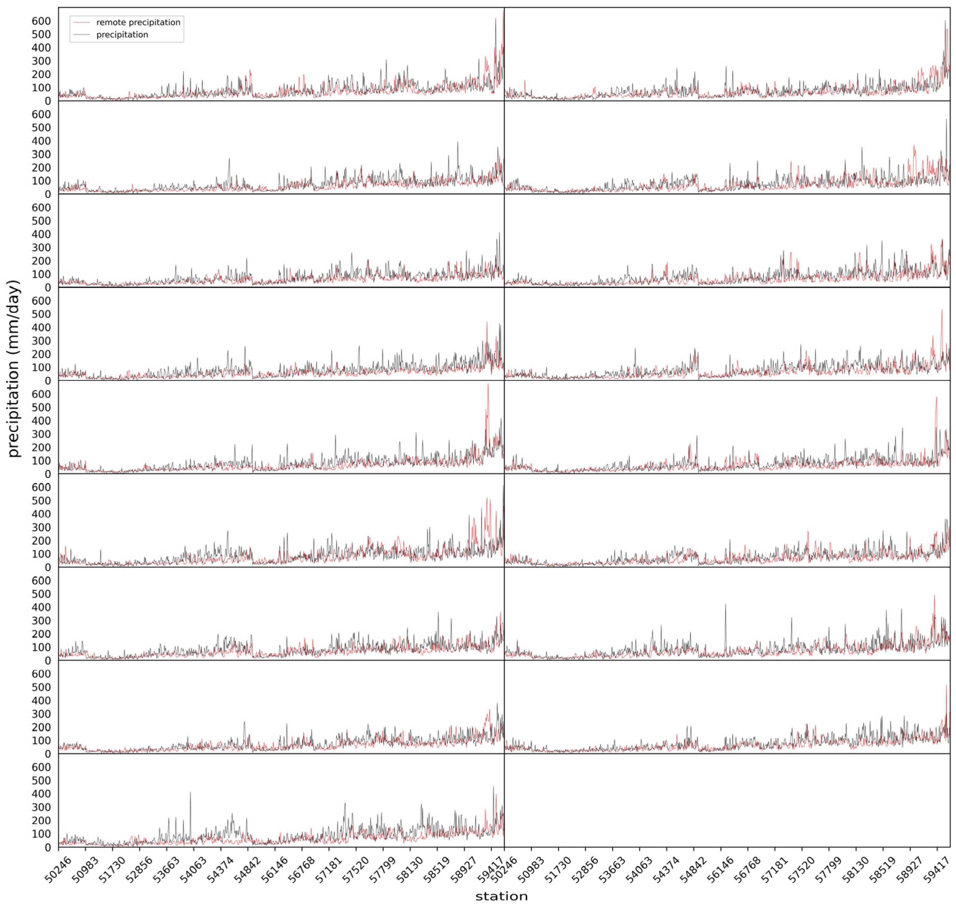
3.2. Overall Performance Evaluation of Satellite Data
3.3. Performance Evaluation of Satellite Data
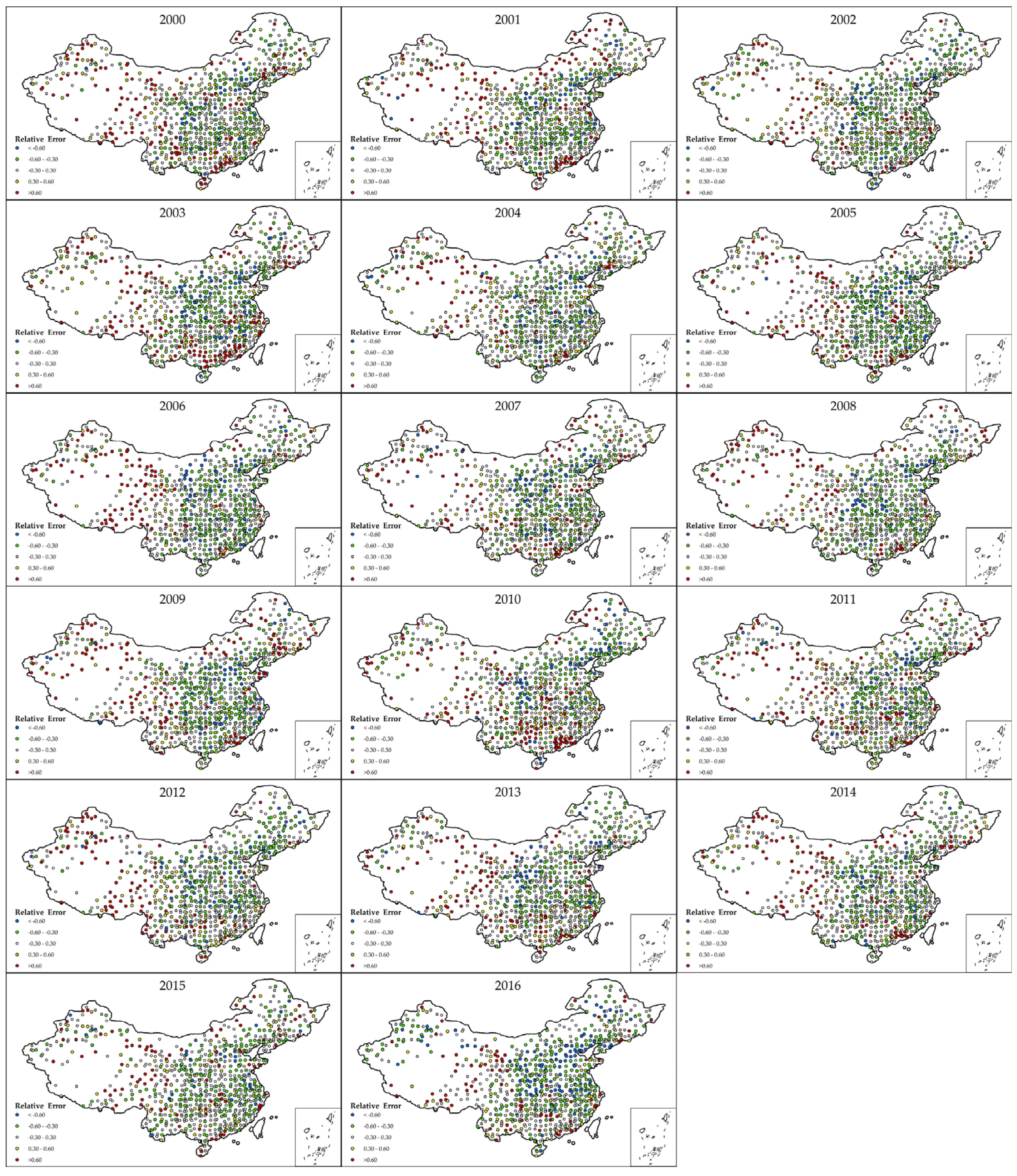
3.3.1. Performance Evaluation of Different Time
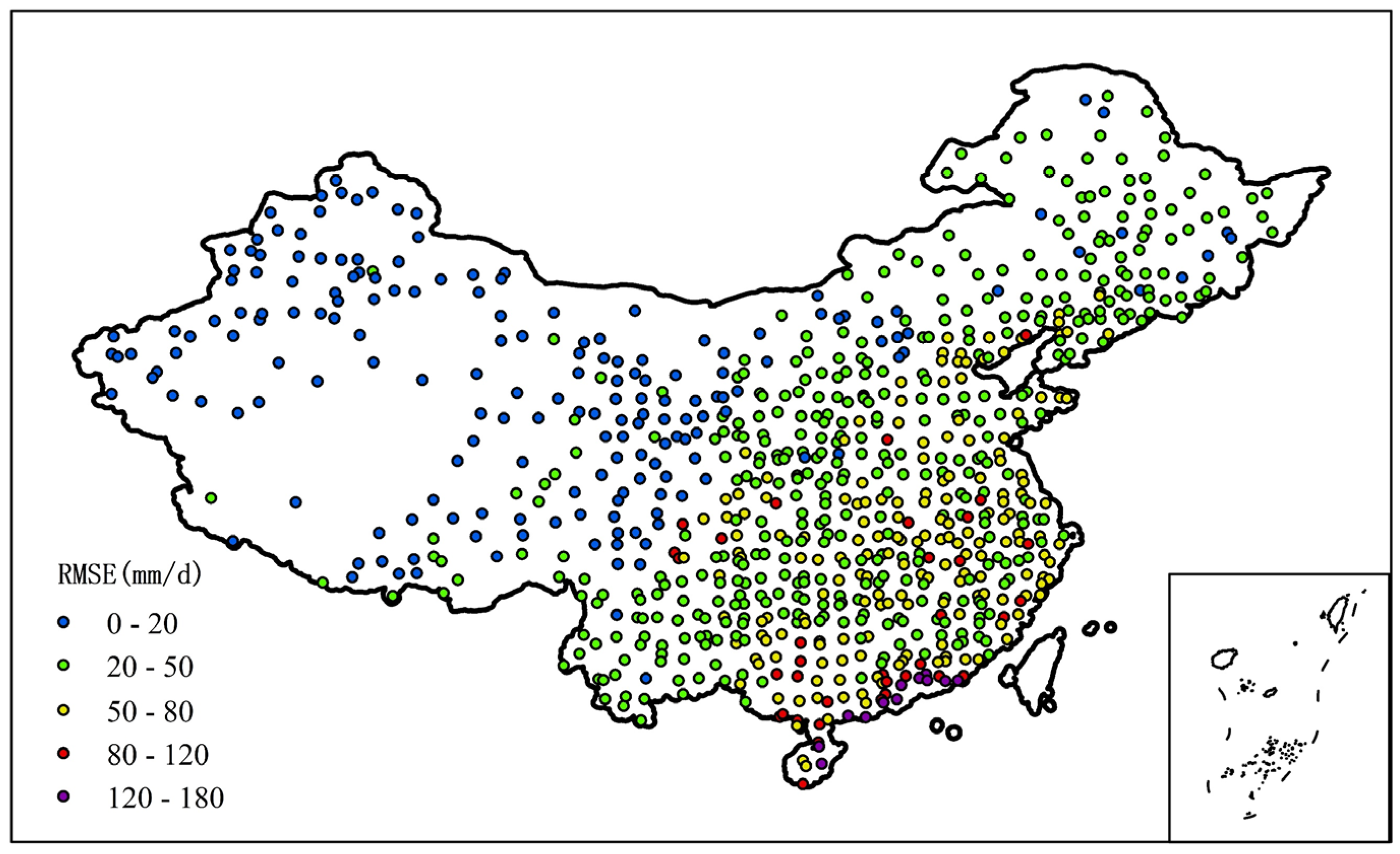
3.3.2. Performance Evaluation of Different Regions
4. Discussion
4.1. Impact of Nighttime Rain on Satellite Precipitation Retrieval
4.2. Impact of Typhoons on Satellite Precipitation Retrieval
5. Conclusions
- This study finds that, in terms of data quality, the PDIR-Now satellite products can capture the spatial distribution of extreme precipitation in the study area. In the assessment of consistency indicators, a moderate correlation is observed between the two datasets, and the assessment of annual data also shows a moderate correlation. In the assessment of error indicators, the values of RMSE and RRMSE are within an acceptable range. From the annual assessment results, the error results for 2010 and 2016 are slightly larger. The analysis attributes this to the fact that these two years were exceptionally wet in China, and due to the impact of the greenhouse effect, although the precipitation was high, the number of rainy days shortened, leading to abrupt alternations between drought and flood. While satellites can capture the occurrence of abnormal precipitation, there is often a significant deviation from the measured values at stations, with 2016 being particularly prominent as the wettest in the past 60 years. The assessment results for the other years fluctuate around the overall trend.
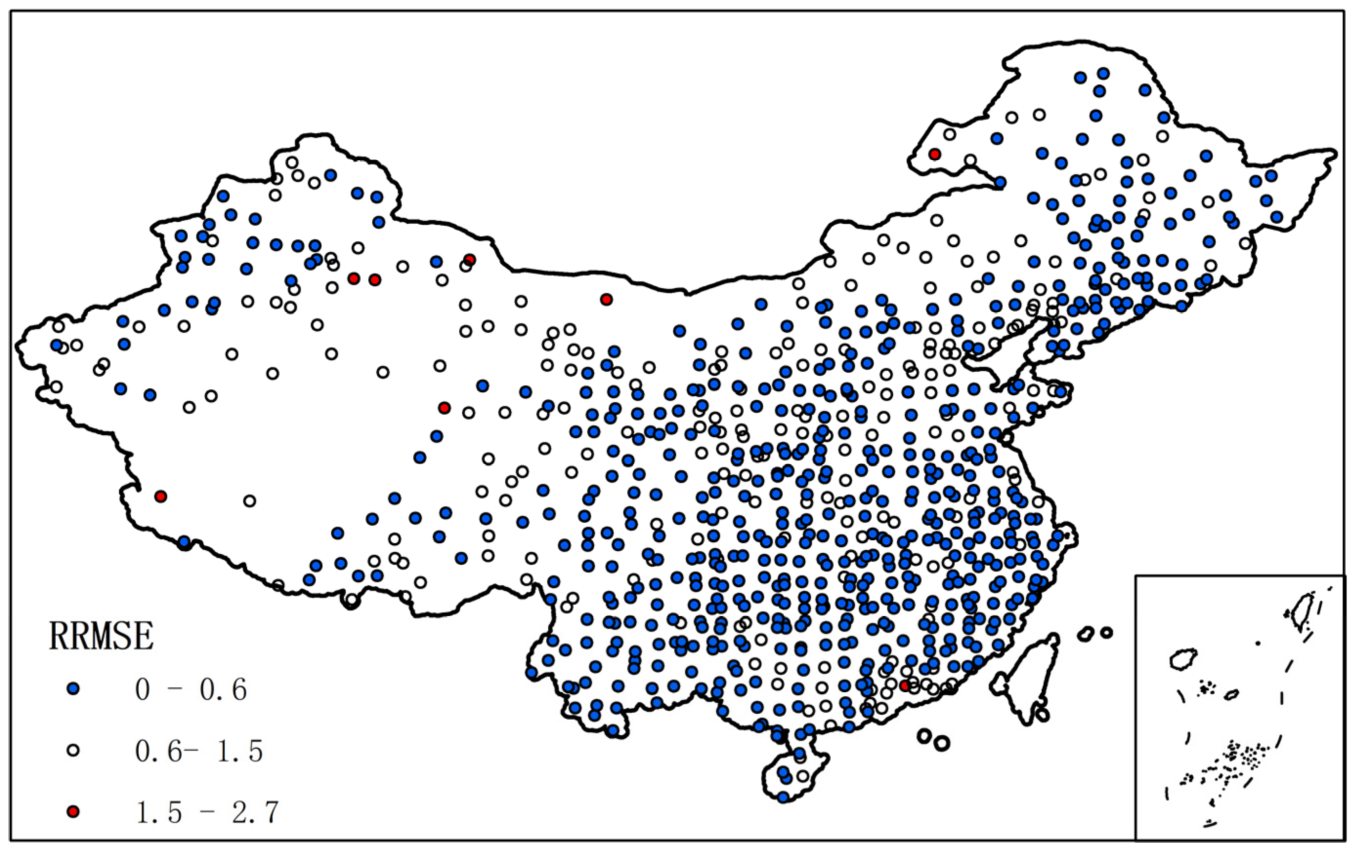
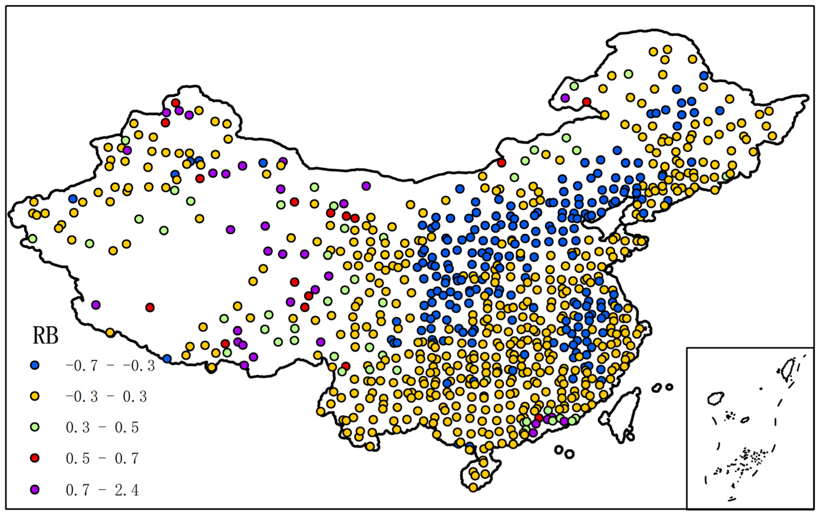
- The inversion error of extreme precipitation from PDIR-Now satellite products exhibits significant regional characteristics in the study area. From the spatial distribution of data, RMSE increases progressively from west to east and from north to south, consistent with the spatial characteristics of precipitation. The RRMSE, RB, and relative deviation of most stations are within the normal range, but larger errors are observed in the northwest, Tibetan Plateau, and coastal areas. Stations with underestimated precipitation are mainly located in semi-arid areas such as the Loess Plateau and its surroundings, while stations with overestimated precipitation are concentrated in arid areas such as the northwest.
- Although the annual maximum daily precipitation extracted from satellites and stations is not synchronized in time, this study reveals a relatively stable relationship between satellite and station data after analyzing the R, RB, RMSE, and RRMSE of 17 years of data from 2000 to 2016. This relationship can be applied to the estimation of rainstorm frequency curves, which is of great significance for flash flood warnings. Furthermore, based on previous research, we know that the larger the time scale, the smaller the simulation error. From the analysis of the annual maximum daily precipitation prediction results of PDIR-Now satellite products, we can infer that the prediction fitting results for 1 h intervals may have larger errors. The analysis also shows that the influence of geographical factors on satellite inversion is significant, indicating considerable room for improvement in satellite algorithms.
Author Contributions
Funding
Data Availability Statement
Acknowledgments
Conflicts of Interest
References
- Sen, Z.; Al-Harithy, S.; As-Sefry, S. Possible climate change implications for Saudi Arabian meteorology station maximum daily rainfall records. Int. J. Glob. Warm. 2018, 14, 488–509. [Google Scholar] [CrossRef]
- Ngo-Duc, T. Rainfall Extremes in Northern Vietnam: A Comprehensive Analysis of Patterns and Trends. Vietnam J. Earth Sci. 2023, 45, 183–198. [Google Scholar] [CrossRef]
- Alharbi, R.S.; Dao, V.; Jimenez Arellano, C.; Nguyen, P. Comprehensive Evaluation of Near-Real-Time Satellite-Based Precipitation: PDIR-Now over Saudi Arabia. Remote Sens. 2024, 16, 703. [Google Scholar] [CrossRef]
- Hou, A.Y.; Kakar, R.K.; Neeck, S.; Azarbarzin, A.A.; Kummerow, C.D.; Kojima, M.; Oki, R.; Nakamura, K.; Iguchi, T. The Global Precipitation Measurement Mission. Bull. Am. Meteorol. Soc. 2014, 95, 701–722. [Google Scholar] [CrossRef]
- Huffman, G.J.; Bolvin, D.T. TRMM and Other Data Precipitation Data Set Documentation; NASA: Greenbelt, MA, USA, 2015. [Google Scholar]
- Joyce, R.J.; Janowiak, J.E.; Arkin, P.A.; Xie, P. CMORPH: A Method that Produces Global Precipitation Estimates from Passive Microwave and Infrared Data at High Spatial and Temporal Resolution. J. Hydrometeorol. 2004, 5, 487–503. [Google Scholar] [CrossRef]
- Guo, B.; Xu, T.; Yang, Q.; Zhang, J.; Dai, Z.; Deng, Y.; Zou, J. Multiple Spatial and Temporal Scales Evaluation of Eight Satellite Precipitation Products in a Mountainous Catchment of South China. Remote Sens. 2023, 15, 1373. [Google Scholar] [CrossRef]
- Navarro, A.; García-Ortega, E.; Merino, A.; Sánchez, J.L. Extreme Events of Precipitation over Complex Terrain Derived from Satellite Data for Climate Applications: An Evaluation of the Southern Slopes of the Pyrenees. Remote Sens. 2020, 12, 2171. [Google Scholar] [CrossRef]
- Bai, L.; Shi, C.; Li, L.; Yang, Y.; Wu, J. Accuracy of CHIRPS Satellite-Rainfall Products over Mainland China. Remote Sens. 2018, 10, 362. [Google Scholar] [CrossRef]
- Bagaglini, L.; Sanò, P.; Casella, D.; Cattani, E.; Panegrossi, G. The Passive Microwave Neural Network Precipitation Retrieval Algorithm for Climate Applications (PNPR-CLIM): Design and Verification. Remote Sens. 2021, 13, 1701. [Google Scholar] [CrossRef]
- Huffman, G.J.; Adler, R.F.; Bolvin, D.T.; Nelkin, E.J.; Wolff, D.B.; Adler, R.F.; Gu, G.; Hong, Y.; Bowman, K.P.; Stocker, E.F. The TRMM Multisatellite Precipitation Analysis (TMPA): Quasi-Global, Multiyear, Combined-Sensor Precipitation Estimates at Fine Scales. J. Hydrometeorol. 2007, 8, 38–55. [Google Scholar] [CrossRef]
- Skofronick-Jackson, G.; Petersen, W.A.; Berg, W.; Kidd, C.; Stocker, E.F.; Kirschbaum, D.B.; Kakar, R.; Braun, S.A.; Huffman, G.J.; Iguchi, T.; et al. The Global Precipitation Measurement (GPM) Mission for Science and Society. Bull. Am. Meteorol. Soc. 2017, 98, 1679–1695. [Google Scholar] [CrossRef]
- Echeta, O.C.; Adjei, K.A.; Andam-Akorful, S.A.; Gyamfi, C.; Darko, D.; Odai, S.N.; Kwarteng, E.V.S. Performance Evaluation of Near-Real-Time Satellite Rainfall Estimates over Three Distinct Climatic Zones in Tropical West-Africa. Environ. Process. 2022, 9, 59. [Google Scholar] [CrossRef]
- Gorooh, V.A.; Shearer, E.J.; Nguyen, P.; Hsu, K.; Sorooshian, S.; Cannon, F.; Ralph, M. Performance of New Near-Real-Time PERSIANN Product (PDIR-Now) for Atmospheric River Events over the Russian River Basin, California. J. Hydrometeorol. 2022, 23, 1899–1911. [Google Scholar] [CrossRef]
- Liu, G.; Zhu, Z.; Tan, X. Evaluation of High-Resolution Remote Sensing Precipitation Products’ Ability to Monitor Heavy Precipitation—A Case Study of Typhoon “Wipha” in 2014. J. Subtrop. Resour. Environ. 2017, 12, 39–48. [Google Scholar]
- Liu, Y.; Wu, Y.; Feng, Z.; Huang, X.; Wang, D. Evaluation of Multiple Satellite Precipitation Products’ Performance in Retrieving Extreme Rainfall in China. Trop. Geogr. 2017, 37, 417–433. [Google Scholar]
- Pang, C. Evaluation of Multiple Satellite Precipitation Products’ Monitoring Ability for Extreme Precipitation in Mainland China. Master’s Thesis, Henan University, Zhengzhou, China, 2023. [Google Scholar]
- Xie, W.; Yi, S.; Leng, C. Impacts of Gauge Data Bias on the Performance Evaluation of Satellite-Based Precipitation Products in the Arid Region of Northwestern China. Water 2022, 14, 1860. [Google Scholar] [CrossRef]
- Nadarajah, S.; Choi, D. Maximum daily rainfall in South Korea. J. Earth Syst. Sci. 2007, 116, 311–320. [Google Scholar] [CrossRef]
- García-Marín, A.P.; Ayuso-Muñoz, J.L.; Taguas-Ruiz, E.V.; Estevez, J. Regional analysis of the annual maximum daily rainfall in the province of Malaga (southern Spain) using the principal component analysis. Water Environ. J. 2011, 25, 522–531. [Google Scholar] [CrossRef]
- Villarini, G.; Smith, J.A.; Ntelekos, A.A.; Schwarz, U. Annual maximum and peaks-over-threshold analyses of daily rainfall accumulations for Austria. J. Geophys. Res. 2011, 116, D05103. [Google Scholar] [CrossRef]
- Donat, M.G.; Alexander, L.V.; Yang, H.; Durre, I.; Vose, R.; Dunn, R.J.H.; Willett, K.M.; Aguilar, E.; Brunet, M.; Caesar, J.; et al. Updated analyses of temperature and precipitation extreme indices since the beginning of the twentieth century: The HadEX2 dataset. J. Geophys. Res. Atmos. 2013, 118, 2098–2118. [Google Scholar] [CrossRef]
- Porto de Carvalho, J.R.; Assad, E.D.; de Oliveira, A.F.; Pinto, H.S. Annual maximum daily rainfall trends in the Midwest, southeast and southern Brazil in the last 71 years. Weather Clim. Extrem. 2014, 5–6, 7–15. [Google Scholar] [CrossRef]
- Wang, T.; Song, C.; Chen, X. Clarifying the relationship between annual maximum daily precipitation and climate variables by wavelet analysis. Atmos. Res. 2023, 295, 106981. [Google Scholar] [CrossRef]
- Wang, Z.; Wilby, R.L.; Yu, D. Spatial and temporal scaling of extreme rainfall in the United Kingdom. Int. J. Climatol. 2024, 44, 286–304. [Google Scholar] [CrossRef]
- Kong, F.; Shi, P.; Fang, J.; Lü, L.; Fang, J.; Guo, J. Research Progress and Prospects on the Temporal and Spatial Patterns of Extreme Precipitation and Its Influencing Factors under the Background of Global Change. Disaster Sci. 2017, 32, 165–174. [Google Scholar]
- Ding, M.; Yong, B.; Yang, Z. Study on the Extreme Precipitation Monitoring Potential of the Global Precipitation Measurement (GPM) Multi-Satellite Combined Precipitation Product. J. Remote Sens. 2022, 26, 657–671. [Google Scholar]
- Yang, X.; Zeng, S.; Lin, Z. Evaluation of GPM Satellite Precipitation Data for Monitoring Extreme Precipitation in Sichuan. Remote Sens. Technol. Appl. 2023, 38, 1496–1508. [Google Scholar]
- Shang, M.; Ren, Y.; Song, H.; Yao, Y.; Bai, L.; Li, Y.; Ma, J. Evaluation of IMERG and GSMaP for Monitoring Extreme Precipitation in China. J. Earth Inf. Sci. 2023, 25, 1813–1826. [Google Scholar]
- Liu, R.; Jiang, S.; Ren, L.; Wei, L.; Wang, M.; Lu, Y. Evaluation of IMERG Precipitation Product from the Global Precipitation Measurement (GPM) Mission for Monitoring Extreme Rainfall in Mainland China. China Rural Water Resour. Hydropower 2021, 4, 57–63. [Google Scholar]
- Yu, J.; Shen, Y.; Pan, Y.; Xiong, A. Comparative Evaluation of China’s Regional Daily Merged Precipitation Dataset and International Precipitation Products. Acta Meteorol. Sin. 2015, 73, 394–410. [Google Scholar]
- Nguyen, P.; Shearer, E.J.; Ombadi, M.; Gorooh, V.A.; Hsu, K.; Sorooshian, S.; Logan, W.S.; Ralph, M. PERSIANN Dynamic Infrared–Rain Rate Model (PDIR) for High-Resolution, Real-Time Satellite Precipitation Estimation. Bull. Am. Meteorol. Soc. 2020, 101, E286–E302. [Google Scholar] [CrossRef]
- Jimenez Arellano, C.; Dao, V.; Afzali Gorooh, V.; Alharbi, R.S.; Nguyen, P. Performance of the PERSIANN Family of Products over the Mekong River Basin and Their Application for the Analysis of Trends in Extreme Precipitation Indices. Atmosphere 2023, 14, 1832. [Google Scholar] [CrossRef]
- Dong, Y.; Gan, F.; Gao, Y.; Diao, X.; Pan, Y. Evaluation of IMERG Satellite Precipitation Data for Drought Monitoring in the Jialing River Basin. Hydrology 2023, 43, 88–95. [Google Scholar]
- Huang, W.R.; Liu, P.Y.; Hsu, J. Multiple timescale assessment of wet season precipitation estimation over Taiwan using the PERSIANN family products. Int. J. Appl. Earth Obs. Geoinf. 2021, 103, 102521. [Google Scholar] [CrossRef]
- Ma, Q.; Li, Y.; Feng, H.; Yu, Q.; Zou, Y.; Liu, F.; Pulatov, B. Performance evaluation and correction of precipitation data using the 20-year IMERG and TMPA precipitation products in diverse subregions of China. Atmos. Res. 2021, 249, 105304. [Google Scholar] [CrossRef]
- Wang, Z.; Shi, Y.; Zhang, T. Does TRMM Satellite Precipitation Underestimate or Overestimate Precipitation in Mainland China? Adv. Earth Sci. 2021, 36, 604–615. [Google Scholar]
- Zhou, Z.; Guo, B.; Xing, W.; Zhou, J.; Xu, F.; Xu, Y. Comprehensive evaluation of latest GPM era IMERG and GSMaP precipitation products over mainland China. Atmos. Res. 2020, 246, 105132. [Google Scholar] [CrossRef]
- Zhao, T.; Yatagai, A. Evaluation of TRMM 3B42 product using a new gauge-based analysis of daily precipitation over China: Evaluation of TRMM 3B42 Product over China. Int. J. Climatol. 2014, 34, 2749–2762. [Google Scholar] [CrossRef]
- Han, F.; Lu, X.; Wu, T.; Xu, Y.; Han, X.; Cai, X. Evaluation of Multi-Satellite Merged Precipitation Products for Monitoring Typhoon Precipitation in Zhejiang Province from 2015 to 2020. Rainstorm Disasters 2023, 42, 57–66. [Google Scholar]
- Ehsani, M.R.; Heflin, S.; Risanto, C.B.; Behrangi, A. How well do satellite and reanalysis precipitation products capture North American monsoon season in Arizona and New Mexico? Weather Clim. Extrem. 2022, 38, 100521. [Google Scholar] [CrossRef]
- Huang, W.R.; Liu, P.Y.; Chang, Y.H.; Lee, C.-A. Evaluation of IMERG Level-3 Products in Depicting the July to October Rainfall over Taiwan: Typhoon Versus Non-Typhoon. Remote Sens. 2021, 13, 622. [Google Scholar] [CrossRef]


| Indicators | R | RMSE | RRMSE | RB |
| Result | 0.6 | 46.5 mm/d | 0.6 | −0.14 |
| Year | 2000 | 2001 | 2002 | 2003 | 2004 | 2005 | 2006 | 2007 | 2008 |
| R | 0.63 | 0.58 | 0.62 | 0.52 | 0.61 | 0.63 | 0.62 | 0.60 | 0.64 |
| Year | 2009 | 2010 | 2011 | 2012 | 2013 | 2014 | 2015 | 2016 | |
| R | 0.53 | 0.54 | 0.59 | 0.61 | 0.62 | 0.62 | 0.68 | 0.53 |
Disclaimer/Publisher’s Note: The statements, opinions and data contained in all publications are solely those of the individual author(s) and contributor(s) and not of MDPI and/or the editor(s). MDPI and/or the editor(s) disclaim responsibility for any injury to people or property resulting from any ideas, methods, instructions or products referred to in the content. |
© 2025 by the authors. Licensee MDPI, Basel, Switzerland. This article is an open access article distributed under the terms and conditions of the Creative Commons Attribution (CC BY) license (https://creativecommons.org/licenses/by/4.0/).
Share and Cite
Zhu, Y.; Chang, G.; Zhang, W.; Guo, J.; Li, X. Evaluation of the Artificial Neural Networks—Dynamic Infrared Rain Rate near Real-Time (PDIR-Now) Satellite’s Ability to Monitor Annual Maximum Daily Precipitation in Mainland China. Water 2025, 17, 308. https://doi.org/10.3390/w17030308
Zhu Y, Chang G, Zhang W, Guo J, Li X. Evaluation of the Artificial Neural Networks—Dynamic Infrared Rain Rate near Real-Time (PDIR-Now) Satellite’s Ability to Monitor Annual Maximum Daily Precipitation in Mainland China. Water. 2025; 17(3):308. https://doi.org/10.3390/w17030308
Chicago/Turabian StyleZhu, Yanping, Gaosong Chang, Wenjiang Zhang, Jingyu Guo, and Xiaodong Li. 2025. "Evaluation of the Artificial Neural Networks—Dynamic Infrared Rain Rate near Real-Time (PDIR-Now) Satellite’s Ability to Monitor Annual Maximum Daily Precipitation in Mainland China" Water 17, no. 3: 308. https://doi.org/10.3390/w17030308
APA StyleZhu, Y., Chang, G., Zhang, W., Guo, J., & Li, X. (2025). Evaluation of the Artificial Neural Networks—Dynamic Infrared Rain Rate near Real-Time (PDIR-Now) Satellite’s Ability to Monitor Annual Maximum Daily Precipitation in Mainland China. Water, 17(3), 308. https://doi.org/10.3390/w17030308