Article

Regional Drought Monitoring Using Satellite-Based Precipitation and Standardized Palmer Drought Index: A Case Study in Henan Province, China

1
College of Water Resources, North China University of Water Resources and Electric Power, Zhengzhou 450046, China
2
Yellow River Institute of Hydraulic Research, Yellow River Conservancy Commission, Zhengzhou 450003, China
3
Engineering Technology Research Center of Intelligent Water Conservancy of Henan Province, Zhengzhou 450003, China
*
Author to whom correspondence should be addressed.
Water 2025, 17(8), 1123; https://doi.org/10.3390/w17081123
Submission received: 13 March 2025 / Revised: 4 April 2025 / Accepted: 7 April 2025 / Published: 9 April 2025

Abstract

:
Drought poses significant challenges to agricultural productivity and water resource sustainability in Henan Province, emphasizing the need for effective monitoring approaches. This study investigates the suitability of the TRMM 3B43V7 satellite precipitation product for drought assessment, based on monthly data from 15 meteorological stations during 1998–2019. Satellite-derived precipitation was compared with ground-based observations, and the Standardized Palmer Drought Index (SPDI) was calculated to determine the optimal monitoring timescale. Statistical metrics, including Nash–Sutcliffe Efficiency (NSE = 0.87) and Pearson correlation coefficient (PCC = 0.88), indicate high consistency between TRMM data and ground measurements. The 12-month SPDI (SPDI-12) was found to be the most effective for capturing historical drought variability. To support integrated drought management, a regionally adaptive framework is recommended, balancing agricultural demands and ecosystem stability through tailored strategies such as enhanced irrigation efficiency in humid regions and ecological restoration in arid zones. These findings provide a foundation for implementing an operational drought monitoring and response system in Henan Province.

1. Introduction

Drought is a climatic phenomenon characterized by a significant decrease or uneven distribution of precipitation over a period of time over an area. This results in insufficient surface water availability, a decline in vegetation cover, and, in severe cases, may lead to ecological degradation and economic losses [1,2,3]. Drought formation is a highly complex process, influenced by a combination of climatic, environmental, and anthropogenic factors. Given its profound impacts, understanding drought severity and its evolution is crucial for effective mitigation and adaptation strategies.
Over the years, numerous drought evaluation indices have been developed to quantify and assess drought severity. More than 100 indices have been proposed, each with its unique approach to addressing the complexities of drought conditions [4,5,6,7]. Among these, the Palmer Drought Severity Index (PDSI) [8,9,10,11] and the Standardized Drought Index (SI) [12,13,14,15] are two of the most widely used and representative indices. These indices have been extensively applied in various regions to monitor and assess drought conditions, offering valuable insights into drought’s spatial and temporal patterns.
Recent studies have focused on refining drought indices to enhance their accuracy and applicability. For instance, many studies have explored the limitations of traditional indices like the PDSI, emphasizing the need for updated methods that consider local climatic variations and changes in environmental conditions. Furthermore, the methodological approaches used in drought analysis have evolved, incorporating advanced statistical techniques, remote sensing data, and climate models to improve the precision of drought predictions.
The PDSI, developed by Wayne Palmer in 1965, is a widely adopted drought metric that quantifies drought conditions based on the water supply–demand balance. By integrating temperature, precipitation, and soil characteristics, the PDSI was initially designed for assessing meteorological drought. A distinguishing feature of the index is its incorporation of both current and antecedent precipitation, enabling it to reflect the cumulative influence of past hydrometeorological conditions on future water availability. Despite its extensive use, the PDSI presents several limitations. Its computational complexity and limited spatial–temporal comparability restrict its broader applicability. Furthermore, its recursive reliance on previous-month values frequently results in a bimodal distribution, which poses significant challenges for conventional time series models attempting to accurately capture its stochastic behavior [12,16,17]. In comparison, Standardized Indices (SIs) such as the Standardized Precipitation Index (SPI) adopt a statistical approach by fitting meteorological variables to probability distribution functions. This method simplifies computation and enhances spatial and temporal comparability, while also allowing for multi-time scale analysis. However, SI metrics lack an underlying physical mechanism and are typically based on a single variable, limiting their ability to simulate the actual hydrological cycle. As a result, while SI provides practical advantages in terms of simplicity and flexibility, it falls short in capturing the physical dynamics of drought processes. Common SIs include the SPI and the Standardized Precipitation Evapotranspiration Index (SPEI).
To address these limitations, Ma [13] applied the theoretical framework and derivation steps of the SI to analyze the probabilistic characteristics of monthly moisture deviations, resulting in the development of the Standardized Palmer Drought Index (SPDI) [16,17,18]. The SPDI integrates the advantages of both the PDSI and the SI, simplifying the calculation process of drought indices while maintaining adaptability across various spatial and temporal scales. It not only retains the wide applicability of PDSI in drought assessment but also incorporates SI’s probabilistic feature analysis, ensuring stable frequency characteristics across multiple time scales. Additionally, the SPDI is designed to flexibly adapt to different climatic conditions, thereby enhancing the comparability and practicality of the index. As such, the SPDI is regarded as a more comprehensive and adaptive drought index, effectively addressing the limitations of PDSI while leveraging the strengths of SI in drought analysis.
Traditional drought monitoring primarily relies on ground-based meteorological stations. However, these stations are often unevenly distributed, particularly in remote or less-developed regions, resulting in a limited monitoring coverage area [19]. This method, which depends on daily or monthly meteorological data (such as precipitation and temperature), often faces a time lag, making it difficult to capture real-time changes in drought conditions [20]. Additionally, the observations from these stations typically represent only the local climate conditions surrounding the station, failing to effectively reflect drought conditions over a larger area, thus leading to inadequate spatial representativeness.
Satellite monitoring technology, with its extensive spatial and temporal coverage, offers global data resources and overcomes the limitations caused by the uneven distribution of ground-based stations. This capability enables real-time monitoring across large regions, particularly in remote or hard-to-access areas such as oceans, where ground-based monitoring is challenging or unfeasible [21]. Furthermore, modern satellites provide high-frequency repeat observations [22], delivering data at daily or near-daily intervals, which supports real-time or near-real-time drought monitoring. This facilitates the rapid detection of drought events and allows for timely response measures. However, it is essential to acknowledge the uncertainties and limitations associated with satellite data, including potential issues with data accuracy, cloud cover interference, and sensor degradation over time [23].
Using various remote sensing techniques—such as optical, microwave, and infrared sensors [24]—satellite monitoring can capture multidimensional drought-related data, including vegetation indices like the Normalized Difference Vegetation Index (NDVI) [25], soil moisture [26], and evapotranspiration [27].These data offer a comprehensive assessment of drought conditions from different perspectives. Furthermore, the high-resolution images and data provided by modern satellites allow for monitoring at fine scales, such as individual farmland plots or forest areas, significantly improving the precision of drought impact assessments [28].With the accumulation of long-term satellite historical data, in-depth analysis of drought patterns across regions is possible, offering crucial data support for the study of climate change and drought trends.
To evaluate the applicability of the Tropical Rainfall Measuring Mission (TRMM) 3B43V7 satellite precipitation product in Henan Province, this study replaces ground-based precipitation data with satellite-derived precipitation data to calculate the SPDI and explores the optimal time scale for analysis. By integrating historical drought event records, the suitability of the SPDI for drought monitoring in Henan Province is assessed. The aim of this research is to validate the rationality and feasibility of developing an operational drought monitoring system for Henan Province based on the TRMM satellite precipitation product and SPDI. The ultimate goal is to provide theoretical and technical support for regional drought prevention and mitigation efforts.

2. Study Area and Dataset

2.1. Study Area Description

Located in the southern part of the North China Plain, the study area lies within the middle and lower reaches of the Yellow River. Its geographical coordinates range from 110°21′ to 116°39′ E and from 31°23′ to 36°22′ N, encompassing an area of approximately 167,000 km2. The eastern and central regions are dominated by broad alluvial plains, while the western part features mountainous terrain, including the Funiu and Taihang mountain ranges. Major river systems such as the Yellow and Huai Rivers, along with their tributaries, define the regional hydrological structure and directly influence agricultural development and water resource allocation. Seasonal variability in river discharge, combined with the simultaneous occurrence of floods and droughts, poses persistent challenges for water resources management.
The region is characterized by a semi-humid continental monsoon climate, with hot and humid summers and cold, dry winters. Annual precipitation ranges from 400 to 1300 mm, with over 60% concentrated between June and August, often triggering flood events during the summer months. In contrast, limited precipitation during winter and spring increases regional drought vulnerability. Droughts represent one of the most frequent and destructive climatic extremes, severely affecting crop production and water supply. Intensifying climate change has amplified these risks, resulting in more erratic drought patterns and greater uncertainty in hydrological planning.
Between 1998 and 2019, the region underwent significant land use transformation driven by rapid urban expansion [29]. Major cities such as Zhengzhou, Luoyang, and Xinxiang experienced substantial growth, with increasing conversion of agricultural land into impervious surfaces. Although farmland remains the predominant land cover, localized shifts toward urbanization are evident. Concurrently, forest protection policies and afforestation initiatives have improved vegetation coverage in certain ecological subregions. These spatiotemporal land use changes are illustrated in Figure 1.

2.2. Dataset

This study collected monthly meteorological observation data from 15 weather stations in Henan Province between 1998 and 2019, provided by the China Meteorological Data Service Center (The specific location is shown in Figure 1d). The data include monthly precipitation and monthly average temperature. Additionally, the TRMM-3B43 V7 satellite precipitation dataset, with a 0.25° grid resolution, was used to obtain monthly precipitation records for the same period (1998–2019) to conduct an accuracy evaluation study and to calculate the Standardized Precipitation Drought Index (SPDI). The TRMM dataset was jointly released by the National Aeronautics and Space Administration (NASA) and the Japan Aerospace Exploration Agency (JAXA) as part of their collaborative TRMM. Based on the findings from references [30,31,32], the available soil water holding capacities for each station were set as follows: 230 mm for Anyang, Xinxiang, Sanmenxia; 240 mm for Zhengzhou, Mengjin, Kaifeng; 250 mm for Xihua, Shangqiu, Baofeng, Xuchang; 260 mm for Xixia, Nanyang; 270 mm for Zhumadian; and 280 mm for Xinyang, Gushi. When estimating potential evapotranspiration (PET) using the Thornthwaite method [33,34], the geographical latitudes of the stations were also incorporated. Moreover, key historical drought events in Henan Province from 1998 to 2019, as documented in the China Drought and Flood Disaster Bulletin, were referenced to validate the performance of the SPDI in assessing historical drought conditions in the province. All collected data are presented in Table 1.

3. Research Methods

3.1. Evaluation of Satellite-Based Precipitation

To comprehensively and accurately assess the precision and applicability of TRMM satellite precipitation data, this study employs various statistical indices to quantitatively analyze the consistency between the satellite-derived precipitation product and ground-based precipitation observations at 15 stations [35,36,37,38,39,40]. The specific metrics used include the following.

3.1.1. Pearson Correlation Coefficient ( P C C )

The P C C is a widely utilized statistical tool in drought research, primarily employed to quantify the linear relationships between drought indices. It plays a crucial role in evaluating drought propagation pathways, assessing the consistency among different drought indices, and analyzing correlations with hydrological variables. The mathematical formula used for calculating Pearson correlation coefficient is as follows:
P C C = 1 n ( G i - G ¯ ) ( S i - S ¯ ) 1 n ( G i - G ¯ ) 2 1 n ( S i - S ¯ ) 2
where S i represents the satellite precipitation products, and G i represents the gauge observations, all on a one-month scale. S ¯ and G ¯ represent the monthly means of the satellite precipitation products and gauge observations, respectively, and n is the sample size.

3.1.2. Mean Absolute Error ( M A E ) and Root Mean Square Error ( M A E )

M A E and R M S E are commonly used error metrics in drought research for evaluating model accuracy. They are widely applied in validating simulations and predictions of drought indices such as SPI and SPEI. M A E measures the average magnitude of errors, making it easy to interpret, while R M S E is more sensitive to large errors, highlighting the impact of extreme deviations. These metrics are often used to compare the performance of different models or methods in drought monitoring and early warning systems. The mathematical formula used for calculating M A E and R M S E is as follows:
M A E = 1 n ( S i G i ) n
R M S E = 1 n ( S i G i ) 2 n
where all symbols have the same meaning as before.

3.1.3. Nash–Sutcliffe Efficiency ( N S E )

The N S E is widely used in drought hydrology to evaluate the accuracy of model simulations for streamflow or drought indices during dry periods. It effectively measures model performance under extreme hydrological conditions, making it particularly valuable for reconstructing drought events and validating early warning systems. Numerous studies have demonstrated that N S E is a critical criterion for assessing hydrological model reliability, especially when models tend to exhibit bias during drought years. The mathematical formula used for calculating N S E is as follows:
N S E = 1 1 i ( S i G i ) 2 1 i ( G i G ¯ ) 2
where all symbols have the same meaning as before.

3.2. Traditional Palmer Drought Indicators

The PDSI is based on the soil water balance model, which quantifies regional drought or wetness by evaluating the supply and demand relationship of precipitation, evapotranspiration, and soil moisture changes. Its calculation relies on precipitation (P), potential evapotranspiration (PET), soil moisture content (SM), and runoff (R), integrating water inputs and outputs to determine the water balance status. The PDSI introduces the concept of “Climatically Appropriate for Existing Condition” (CAFEC) precipitation [41,42,43], which is defined as the minimum amount of precipitation required to maintain normal soil moisture levels in a given area and is compared against actual or observed precipitation. The core methodology adopts CAFEC to compare current water supply and demand with climate-appropriate conditions and calculates deviations in wetness and dryness through the water balance equation and standardization, thereby providing an accurate assessment of regional drought conditions.
The amount of CAFEC precipitation depends on the local climate conditions and is calculated as follows in different months:
P C A F E C = α i P E T + β i P R + γ i P R D δ i P L
where P C A F E C is the CAFEC precipitation; i is for the months of the year from January to December; α , β , γ and δ are the weight factors (or water balance factors) for each month ( i = 1, 2, to 12) in a specific region, estimated via the following:
α i = E T i ¯ P E T i ¯ , β i = R i ¯ P R i , γ i = R D i ¯ P R D i , δ i = L i ¯ P L i
where the calculation of α , β , γ and δ involves eight hydrological components related to soil water in each month of the year, namely evapotranspiration E T , possible evapotranspiration P E T , soil water recharge R , soil possible water recharge P R , runoff depth R D , possible runoff depth P R D , soil water loss L and soil possible water loss P L ; the values of these variables are closely related to the local available soil water content (AWC).
The PDSI uses the difference between actual precipitation and CAFEC precipitation (called moisture deviation) to reflect the abnormal water status (dry or wet) of a certain area at a specific time:
d ˜ = P P C A F E C = P ( α i P E T + β i P R + γ i P R D δ i P L )
where P represents the observed precipitation, and d ˜ denotes the moisture deviation. The Palmer moisture deviation d ˜ reflects abnormal moisture conditions by comprehensively accounting for precipitation, evapotranspiration, runoff, and soil moisture content, among a series of meteorological and hydrological processes.
After obtaining the moisture deviation d ˜ series for each month, the PDSI, PMDI, PHDI and ZIND index can be further calculated according to the corresponding method [44,45].

3.3. Construction of Standardized Palmer Drought Index

The SPDI is essentially a simplified application of the PDSI. It simplifies and improves PDSI by using the standardization method of the SI to replace the complex standardization process of moisture deviation.
Although the Pearson Type III distribution and the Generalized Extreme Value distribution provide the closest fit to the sample data, the former has certain limitations in reflecting the probability of some extreme values of the moisture deviation d ˜ . For instance, for smaller moisture deviation d ˜ values, the cumulative probability values obtained by the Pearson Type III distribution are also extremely small, with many probabilities even equal to zero. This issue can impede the standard normal transformation process required for estimating SPDI values at the corresponding extreme points [15].
The probability distribution function of the Generalized Extreme Value (GEV) distribution is expressed as follows:
F ( x ) = exp 1 k x μ α 1 k
where x represents the time series of moisture deviation d ˜ ; μ , α and k are the location, scale, and shape parameters of the GEV distribution, respectively, which can be estimated using the maximum likelihood method.
After obtaining the cumulative probability distribution function of the water deviation ( d ˜ ) series, the cumulative probability value F ( x ) can be further transformed into the corresponding quantile of the standard normal distribution using the classical formula for normalization [46]. This result constitutes the SPDI value:
S P D I = W a 0 + a 1 W + a 2 W 2 1 + b 1 W + b 2 W 2 + b 3 W 3
where p = 1 F ( x ) represents the exceedance probability corresponding to a certain moisture deviation value d ˜ , and when p 0.5 , W = 2 ln ( p ) ; otherwise, W = 2 ln ( 1 p ) , and the calculated SPDI value is assigned an opposite sign. a 0 = 2.515517, a 1 = 0.802853, a 2 = 0.010328, b 1 = 1.432788, b 2 = 0.189269, and b 3 = 0.001308. The SPDI values calculated based on this approach approximately follow a standard normal distribution with a mean of 0 and a standard deviation of 1 and use the same drought and wet classification criteria as the SPI and SPEI. Consequently, a specific SPDI value has the same significance across different locations and times, representing identical moisture conditions and allowing for a direct comparison of SPDI values between various locations and times.
The normalization process of Equation (9) can be summarized as follows [47]: First, the exceedance probability is calculated based on the cumulative distribution function of the deviation values, which is then transformed into the initial variable. Subsequently, a set of nonlinear parameters, including quadratic and cubic terms, is applied to adjust the distribution, effectively stretching and shifting it towards an approximate standard normal distribution. This transformation ensures that the SPDI values have a mean of 0 and a standard deviation of 1, facilitating direct comparisons of drought severity across different times and locations. As the formula is based on an approximation to the standard normal distribution, we further conducted a standard normality test using the Kolmogorov–Smirnov test. At a 95% confidence level, the test was passed, indicating that the results of the formula fitting closely align with a standard normal distribution.
Taking the 12-month time scale at the Zhengzhou station as an example (based on satellite precipitation data), Figure 2 illustrates the fitting of the GEV distribution to the cumulative moisture deviation d ˜ series for 12 different ending months. It can be observed that the various GEV distributions accurately reflect the probability distribution characteristics of the sliding cumulative moisture deviation d ˜ over different ending periods.

4. Results and Analyses

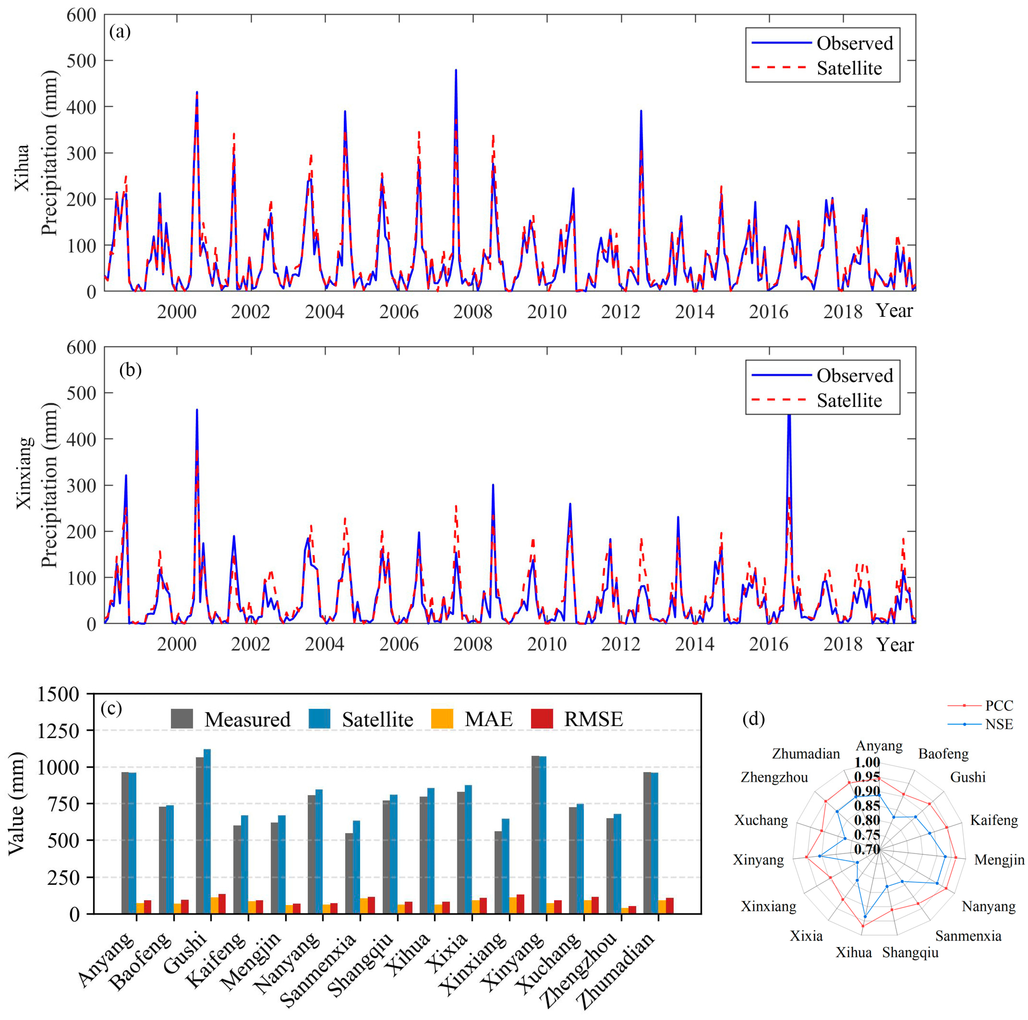
4.1. Accuracy of Satellite-Based Precipitation Product

By comparing the satellite-derived precipitation data with the multi-year average precipitation observed at ground stations (see Figure 3a), it is evident that the satellite estimates generally align well with ground-based measurements across most locations. However, satellite measurements are usually slightly higher than actual ground observations. The PCCs between the TRMM satellite-based and ground-observed monthly precipitation series at each station are presented in Figure 3b. The results indicate a strong agreement, with most stations exhibiting correlation coefficients above 0.8 and an overall mean PCC of 0.88. Among the stations, Xihua recorded the highest PCC of 0.968, while Mengjin exhibited the lowest value at 0.893.
The MAE of the multi-year average precipitation between the TRMM satellite data and ground observations at each station is illustrated in Figure 3a. The maximum MAE is found at Sanmenxia (101.3 mm) and the minimum at Zhengzhou (41.1 mm). Figure 3a shows the RMSE values of satellite precipitation data compared to observed precipitation data at various meteorological stations, reflecting differences in error across stations. Shangqiu and Baofeng have the highest MAE values, around 32, indicating the lower accuracy of satellite data in these areas, while Gushi has the lowest RMSE value at 15, showing higher accuracy in that region. Overall, Figure 3b reveals variations in the performance of satellite data across stations, providing a basis for assessing data accuracy regionally.
The Nash–Sutcliffe Efficiency (NSE) values calculated for satellite precipitation compared to observed precipitation across different meteorological stations in Henan Province have a mean value of 0.87, indicating a generally strong alignment between satellite and observed data. The values range from 0.78 (Xinxiang) to 0.93 (Xihua), with stations like Xihua, Nanyang, and Gushi showing particularly high accuracy, exceeding 0.9. The distribution of these NSE values is illustrated in Figure 3b, reflecting a high degree of consistency between satellite, and observed precipitation data across the region.
Based on the above analysis, it can be concluded that the TRMM 3B43V7 satellite precipitation product exhibits high reliability in the study area. Therefore, using satellite precipitation data as a substitute for ground-based observations in drought index calculations can adequately meet the requirements of subsequent research.

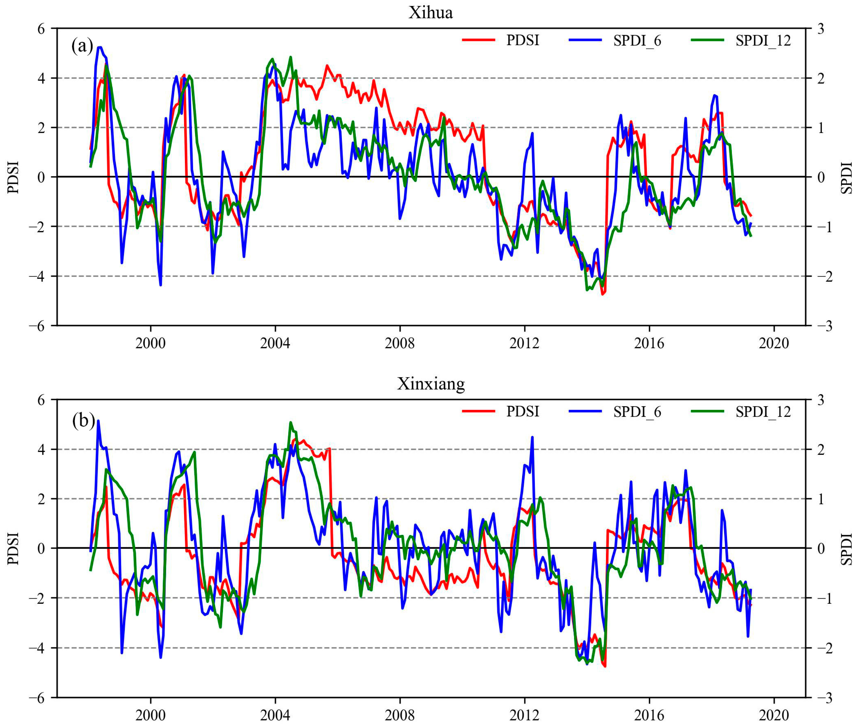
4.2. Time Series of Drought Indices

First, the reliability of the SPDI results was assessed by comparing them with the PDSI. In this study, the monthly series of drought PDSIs were calculated for 15 meteorological stations. We calculate Pearson, Spearman and Kendall correlation coefficients using the satellite precipitation and measured precipitation each month. There is a missing value in the measured precipitation. To make up for this problem, we replace the missing value with the average precipitation of the month for many years. Results show that there is little difference between the Pearson correlation coefficient and the other two correlation coefficients and that the three correlation coefficients can reflect good consistency. Therefore, the Pearson correlation coefficient between the SPDI and PSDI for each station is shown in Figure 4. As shown in the figure, a strong correlation is observed at the 12-month time scale across all 15 stations, with the highest correlation coefficient reaching approximately 0.85. Additionally, the correlation at the 6-month time scale is very close, being only slightly lower than that at the 12-month scale. However, some stations, including Xixia, Nanyang, and Sanmenxia, exhibit slightly lower correlations, with coefficients ranging from 0.53 to 0.79.
The reasons for this variation are twofold: on one hand, it may be related to the inherent applicability of the PDSI, which is less suitable for regions with higher precipitation [48]. This limitation may also affect the SPDI, resulting in a slightly lower correlation coefficient. On the other hand, the terrain’s topography may influence the accuracy of the TRMM 3B43 product, potentially leading to overestimation in some mountainous and plain areas. Overall, the correlation between the SPDI and PDSI is relatively strong, indicating that the SPDI can adequately serve as a substitute for the PDSI.
The consistency between the SPDI and PDSI is also evident in the historical evolution of the monthly drought index. Taking Xihua and Xinxiang stations as examples (see Figure 5), the early years of the 21st century at Xihua station experienced a predominantly wet period, with intermittent drought conditions. From 2012 onwards, a notable drying trend emerged, culminating in severe droughts between 2013 and 2015, with the SPDI_12 and PDSI reflecting these periods of droughts and wetness. Notably, Xinxiang also exhibits the highest correlation coefficient between the SPDI and PDSI, suggesting a strong agreement between the indices at this location.
In contrast, Xinxiang station displayed more pronounced fluctuations in the monthly drought index, with frequent shifts between drought and wet conditions. Apart from the sustained wet period from 2003 to 2005 and severe droughts during 2001–2002 and 2018–2019, the station generally exhibited an alternating pattern of drought and wetness. However, Xinxiang has the lowest correlation coefficient between the SPDI and PDSI, which may be due to the index’s reduced adaptability to local terrain features. Similar variations in monthly drought index were observed across other stations.
Overall, the SPDI_12 and PDSI responses to drought and wet periods demonstrate high consistency, indicating no substantial discrepancies between the indices.

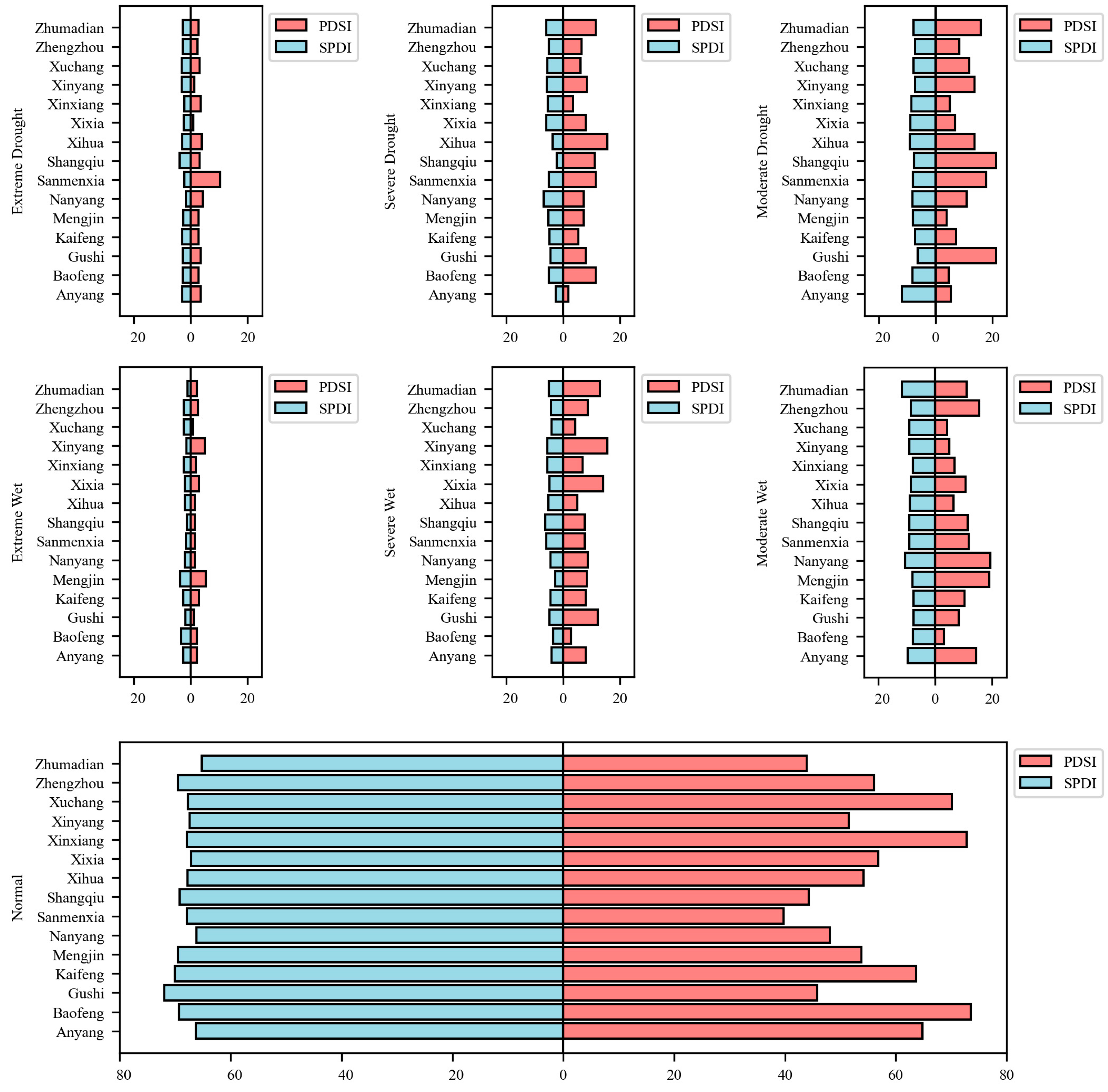
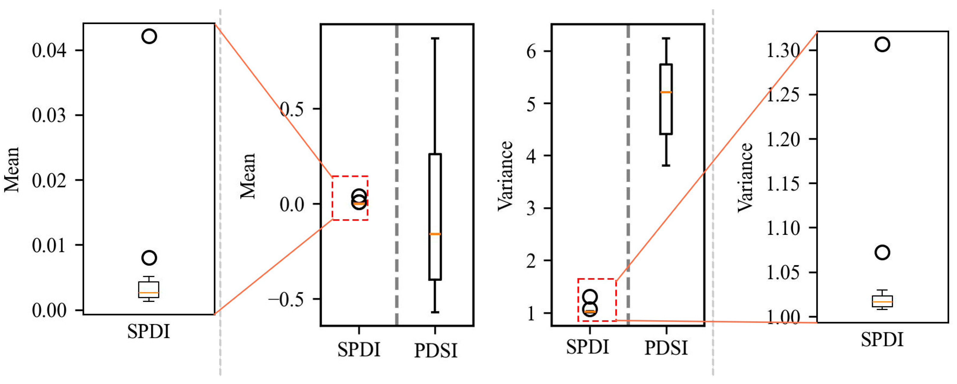
4.3. Statistical Characteristics of Drought Index

Based on the drought and wet classification standards for the SPDI and PDSI (see Table 2), a comparative analysis was conducted to examine the long-term statistical characteristics and the resulting frequencies of drought and wet occurrences. It was observed that the SPDI has a very consistent mean and variance across all stations, which are approximately 0 and 1, respectively, aligning with its standardized normal characteristics. In contrast, the mean and variance of the PDSI vary significantly among different stations.
The distributions of drought and wetness conditions across stations, as measured by SPDI and PDSI, reveal notable differences in frequency and classification. Figure 6 displays the station-level frequency distributions for each drought and wetness category identified by both indices. Considering the differences in the classification of drought and wet levels between the SPDI and PDSI, this study only considers events of moderate intensity or higher. The results show that the SPDI reflects relatively consistent frequencies for the same level of drought or wetness at the same station, and the frequencies of different levels are stable across stations: moderate droughts/wetness account for approximately 14–18%, severe droughts/wetness for about 5–8%, and extreme droughts/wetness for roughly 1–3%.
The SPDI exhibits a mean and variance close to 0 and 1, respectively, across all stations, reflecting its standardized formulation. In contrast, the PDSI displays notable spatial variability in both statistical parameters, with station-level means and variances differing substantially. This highlights the non-standardized nature of the PDSI and its sensitivity to local climatic and hydrological conditions. Figure 7 presents the comparative distribution of mean and variance values for the SPDI and PDSI at each station.
The SPDI, by design, ensures consistent statistical characteristics and stable frequencies across different locations and time scales through its alternative standardization method for monthly moisture deviations. This approach enhances the spatial and temporal comparability of the SPDI, making it a robust tool for drought monitoring. In contrast, the PDSI exhibits considerable variability in the frequencies of drought and wet conditions at the same station, with significant differences observed in the frequencies of different drought severity levels among stations. These inconsistencies are primarily due to the limitations of the PDSI, which is constrained by regional and station-specific data, as well as its reliance on soil water balance models that are sensitive to local conditions. Consequently, the PDSI struggles to maintain uniformity in its representation of drought and wet conditions across varying spatial and temporal scales, thereby limiting its comparability.

4.4. Validation with Historical Drought Records

The years 2012 and 2014 were selected as representative drought years to evaluate the performance of the SPDI-12 in assessing historical droughts in Henan Province. By comparing the identified drought events with historical records from official yearbooks, the accuracy of the SPDI-12 in capturing drought processes becomes evident.
From early 2012 to June 20, precipitation in Henan Province decreased by approximately 40% compared to the same period in previous years. In May, precipitation was only 27 mm, representing a 63% reduction from the previous year, and the lowest value recorded between 2002 and 2012. Meanwhile, temperatures were 1–3 °C higher than average, which further exacerbated drought conditions, particularly during early to mid-June, when persistent high temperatures significantly accelerated soil moisture loss. As shown in Figure 8a, the SPDI-12 trend clearly indicates that drought conditions in certain regions began to alleviate following rainfall on June 23, consistent with the drought processes described by the SPI. This demonstrates the high sensitivity of the SPDI-12 in reflecting the impact of climate anomalies on drought.
Drought conditions in Henan Province during 2014 also show changes in the drought indices, as depicted in Figure 8a, with rapid intensification starting in June. By July, the province experienced the most severe summer drought in 60 years, accompanied by widespread water shortages. The drought peaked in late August, with the PDSI dropping to nearly −6, and eased only after rainfall in early September. The SPI12, SPDI-12, and PDSI trends shown in Figure 8a reflect the severity and persistence of the 2014 summer drought. Particularly in regions such as Xuchang, Baofeng, and Zhumadian, fluctuations in the SPDI-12 and PDSI clearly indicate the onset of drought in early June and its alleviation following September rainfall, further verifying the effectiveness of the SPDI-12 in capturing the occurrence and evolution of drought.
The significant impact of drought on agricultural production is further illustrated in Figure 8b, which shows the areas affected by agricultural losses of varying severity from 2006 to 2019. It is evident that 201 and 2014 had a substantial impact on agricultural production, with 2014 being the most severe year in terms of production losses. During that year, more than 80% of the affected areas suffered extreme losses.
Notably, the SPDI-12 demonstrated a high degree of sensitivity during the droughts of 2012 and 2014, clearly capturing the processes of drought occurrence, development, and alleviation. Particularly during the recovery phase of the 2012 drought, SPDI-12 exhibited a rapid response to the restoration of soil moisture following rainfall, showcasing its capability to monitor drought dynamics with high temporal resolution.
In contrast, agricultural production losses in other years were generally smaller, with almost no major losses observed between 2016 and 2019. This suggests that the frequency and intensity of extreme droughts may have decreased over time, potentially as a result of improved agricultural drought mitigation measures, such as enhanced irrigation systems and climate-adaptive farming practices, alongside broader climate regulation efforts.
Moreover, the SPDI-12 not only accurately captures the severity of droughts but also effectively identifies their spatial distribution and duration. Compared to the SPI and PDSI, the SPDI-12 integrates the strengths of both indices, offering higher precision in monitoring the spatiotemporal variability of droughts. This unique capability establishes SPDI-12 as a robust and powerful tool for drought monitoring and agricultural impact assessment in the context of climate anomalies.

5. Conclusions

This study utilized monthly meteorological observation data from 15 stations in Henan Province and monthly TRMM 3B43V7 satellite precipitation data from 1998 to 2019. Multiple statistical indices were employed to evaluate the applicability of the TRMM 3B43V7 satellite precipitation product in the region. The Standardized Palmer Drought Index (SPDI) was calculated using satellite precipitation data as a substitute for ground-based observations, with the optimal time scale being identified. The suitability of the SPDI for drought monitoring in Henan Province was then assessed in comparison with historical drought event records. The main conclusions are as follows:
(1) The TRMM 3B43V7 satellite-derived precipitation data exhibit a high correlation with ground observation data, indicating that satellite data can effectively substitute ground-based observations for SPDI calculations, particularly in plain areas. The mean Pearson correlation coefficient between satellite and ground data at the monthly scale is 0.93, while the mean Nash–Sutcliffe Efficiency (NSE) is 0.87.
(2) The SPDI exhibits a consistent mean and variance across different stations, of approximately 0 and 1, respectively, aligning with its standardized normal characteristics. At all stations, the SPDI-12 shows a strong correlation with the PDSI, providing a consistent description of drought and wet conditions.
(3) The drought processes identified by the SPDI-12, calculated using satellite precipitation data, closely match the historical drought events recorded in yearbooks. This indicates that the TRMM 3B43V7 satellite precipitation data can be used to calculate the SPDI for drought monitoring in Henan Province, with the SPDI-12 showing the best applicability.
The proposed framework provides a theoretical and practical basis for drought monitoring and management in China, enabling more accurate drought predictions and supporting sustainable water resource management nationwide. To further expand its applicability, we recommend a regionally adaptive implementation strategy. First, meteorological and precipitation data should be collected for the target region and compared with historical drought events to account for local climatic variability [49]. Second, SPDI parameters should be adjusted according to geographical and climatic conditions—for instance, applying multi-temporal analysis in humid regions and emphasizing evapotranspiration (ET) estimation in arid areas [50,51]. Finally, the SPDI method should be validated through retrospective comparisons with actual drought events, and pilot studies should be conducted in regions with varying ecological conditions [52,53].

Author Contributions

Conceptualization, M.M. and H.Z.; methodology, F.X.; software, F.X.; validation, M.M., H.Z., C.Z. and F.X.; formal analysis, Y.W.; investigation, Y.H.; resources, M.M. and C.Z.; data curation, F.X.; writing—original draft preparation, M.M. and C.Z.; writing—review and editing, H.Z.; visualization, F.X. and C.Z.; supervision, H.Z.; project administration, Y.W.; funding acquisition, H.Z and C.Z. All authors have read and agreed to the published version of the manuscript.

Funding

This research was funded by the National Key R&D Program of China (2023YFC3209300) and the National Natural Science Foundation of China (41701022 and 51979106).

Data Availability Statement

All data generated or analyzed are included in this published article.

Acknowledgments

The authors acknowledge the support from the relevant funding agencies and thank MDPI, the Water editorial team, and all reviewers for their valuable comments and rigorous review, which greatly improved the quality of this manuscript. The programming environment platforms of MATLAB R2018a and Python 3.12.5 are also acknowledged.

Conflicts of Interest

The authors declare no conflicts of interest.

References

  1. Jun, Z.; Guiya, C.; Wenfa, Y. Overview of drought research in and outside China. People’s Yangtze 2011, 42, 65–69. [Google Scholar] [CrossRef]
  2. Guiqin, J. Research on Drought Driving Mechanism and Evaluation Method. Ph.D. Thesis, China Institute of Water Resources and Hydropower Research, Beijing, China, 2013. [Google Scholar]
  3. Yunyun, L. Drought Assessment—Propagation-Drive—Prediction of River basins under climate and land use change. Ph.D. Thesis, Xi’an University of Technology, Xi’an, China, 2018. [Google Scholar]
  4. Jinsong, W.; Jiangyong, G.; Yuewu, Z.; Lanfang, Y. Progress and prospect of drought index research. Arid. Land Geogr. 2007, 30, 60–65. [Google Scholar] [CrossRef]
  5. Mingwei, M. Multivariate Drought Monitoring and Evaluation Methods and Applications, 1st ed.; China Water Resources and Hydropower Press: Beijing, China, 2019; p. 148. [Google Scholar]
  6. Bozhen, L.; Guangsheng, Z. Research progress of drought indicators. Acta Ecol. Sin. 2014, 34, 1043–1052. [Google Scholar]
  7. Yiping, L.; Yaohui, L. Research progress on adaptability of meteorological drought index in China. J. Arid. Meteorol. 2017, 35, 709–723. [Google Scholar]
  8. Rashid, M.M.; Beecham, S. Development of a non-stationary Standardized Precipitation Index and its application to a South Australian climate. Sci. Total Environ. 2019, 657, 882–892. [Google Scholar] [CrossRef]
  9. Lorenzo, M.N.; Pereira, H.; Alvarez, I.; Dias, J.M. Standardized Precipitation Index (SPI) evolution over the Iberian Peninsula during the 21st century. Atmos. Res. 2024, 297, 107132. [Google Scholar] [CrossRef]
  10. Mupepi, O.; Matsa, M.M. A combination of vegetation condition index, standardized precipitation index and human observation in monitoring spatio-temporal dynamics of drought. A case of Zvishavane District in Zimbabwe. Environ. Dev. 2023, 45, 100802. [Google Scholar] [CrossRef]
  11. He, Q.; Wang, M.; Liu, K.; Wang, B. High-resolution Standardized Precipitation Evapotranspiration Index (SPEI) reveals trends in drought and vegetation water availability in China. Geogr. Sustain. 2024, 6, 100228. [Google Scholar] [CrossRef]
  12. Dai, A. Characteristics and trends in various forms of the Palmer Drought Severity Index during 1900–2008. J. Geophys. Res. Atmos. 2011, 116. [Google Scholar] [CrossRef]
  13. Mingwei, M. Improvement and Application of Palmer Drought Indices for Drought Characterization. Ph.D. Thesis, Hohai University, Nanjing, China, 2015. [Google Scholar]
  14. Ma, M.; Wang, W.; Yuan, F.; Ren, L.; Tu, X.; Zang, H. Application of a hybrid multiscalar indicator in drought identification in Beijing and Guangzhou, China. Water Sci. Eng. 2018, 11, 177–186. [Google Scholar] [CrossRef]
  15. Ma, M.; Ren, L.; Yuan, F.; Jiang, S.; Liu, Y.; Kong, H.; Gong, L. A new standardized Palmer drought index for hydro-meteorological use. Hydrol. Process. 2014, 28, 5645–5661. [Google Scholar] [CrossRef]
  16. Wang, Z.; Yang, Y.; Zhang, C.; Guo, H.; Hou, Y. Historical and future Palmer Drought Severity Index with improved hydrological modeling. J. Hydrol. 2022, 610, 127941. [Google Scholar] [CrossRef]
  17. Yu, H.; Zhang, Q.; Xu, C.-Y.; Du, J.; Sun, P.; Hu, P. Modified Palmer Drought Severity Index: Model improvement and application. Environ. Int. 2019, 130, 104951. [Google Scholar] [CrossRef] [PubMed]
  18. Ma, M.; Ren, L.; Singh, V.P.; Yang, X.; Yuan, F.; Jiang, S. New variants of the Palmer drought scheme capable of integrated utility. J. Hydrol. 2014, 519, 1108–1119. [Google Scholar] [CrossRef]
  19. Xiao, S.; Zou, L.; Xia, J.; Yang, Z.; Yao, T. Bias correction framework for satellite precipitation products using a rain/no rain discriminative model. Sci. Total Environ. 2022, 818, 151679. [Google Scholar] [CrossRef] [PubMed]
  20. Mishra, A.K. Improving precipitation estimates over orographic regions by integrating multi-spectral satellite observations with rain gauge in India. Remote Sens. Appl. Soc. Environ. 2019, 15, 100252. [Google Scholar] [CrossRef]
  21. Yu, C.; Hu, D.; Shao, H.; Dai, X.; Liu, G.; Wu, S. Runoff simulation driven by multi-source satellite data based on hydrological mechanism algorithm and deep learning network. J. Hydrol. Reg. Stud. 2024, 52, 101720. [Google Scholar] [CrossRef]
  22. Bandara, K.M.P.S. Monitoring irrigation performance in Sri Lanka with high-frequency satellite measurements during the dry season. Agric. Water Manag. 2003, 58, 159–170. [Google Scholar] [CrossRef]
  23. Atiah, W.A.; Johnson, R.; Muthoni, F.K.; Mengistu, G.T.; Amekudzi, L.K.; Kwabena, O.; Kizito, F. Bias correction and spatial disaggregation of satellite-based data for the detection of rainfall seasonality indices. Heliyon 2023, 9, e17604. [Google Scholar] [CrossRef]
  24. Suh, J.W.; Zhu, Z.; Zhao, Y. Monitoring construction changes using dense satellite time series and deep learning. Remote Sens. Environ. 2024, 309, 114207. [Google Scholar] [CrossRef]
  25. Granero-Belinchon, C.; Adeline, K.; Briottet, X. Impact of the number of dates and their sampling on a NDVI time series reconstruction methodology to monitor urban trees with Venμs satellite. Int. J. Appl. Earth Obs. Geoinf. 2021, 95, 102257. [Google Scholar] [CrossRef]
  26. Wang, W.; Ma, C.; Wang, X.; Feng, J.; Dong, L.; Kang, J.; Jin, R.; Li, X. A soil moisture experiment for validating high-resolution satellite products and monitoring irrigation at agricultural field scale. Agric. Water Manag. 2024, 304, 109071. [Google Scholar] [CrossRef]
  27. Zheng, C.; Jia, L.; Hu, G. Global land surface evapotranspiration monitoring by ETMonitor model driven by multi-source satellite earth observations. J. Hydrol. 2022, 613, 128444. [Google Scholar] [CrossRef]
  28. Christian, J.I.; Basara, J.B.; Lowman, L.E.L.; Xiao, X.; Mesheske, D.; Zhou, Y. Flash drought identification from satellite-based land surface water index. Remote Sens. Appl. Soc. Environ. 2022, 26, 100770. [Google Scholar] [CrossRef]
  29. Huang, J.Y.a.X. The 30m annual land cover dataset and its dynamics in China from 1990 to 2019. Earth Syst. Sci. Data 2021, 13, 3907–3925. [Google Scholar] [CrossRef]
  30. Yang, Y.; Shunqing, A.; Weiwei, L.; Sheng, X.; Guoliang, Z.; Jianguo, Q.; Lin, W.; Wen, Z. Application of Palmer drought index method in national real-time drought monitoring. Adv. Water Sci. 2007, 18, 52–57. [Google Scholar]
  31. An Shunqing, X.J. Correction of Palmer drought model. J. Acad. Meteorol. Sci. 1986, 1, 79–82. [Google Scholar]
  32. Liu Weiwei, A.S.; Gengshan, L. Further modification of the Palmer drought model. J. Appl. Meteorol. 2004, 2, 207–216. [Google Scholar]
  33. Chen, D.; Gao, G.; Xu, C.Y.; Guo, J.; Ren, G. Comparison of the Thornthwaite method and pan data with the standard Penman-Monteith estimates of reference evapotranspiration in China. Clim. Res. 2005, 28, 123–132. [Google Scholar] [CrossRef]
  34. Van der Schrier, G.; Jones, P.D.; Briffa, K.R. The sensitivity of the PDSI to the Thornthwaite and Penman-Monteith parameterizations for potential evapotranspiration. J. Geophys. Res. Atmos. 2011, 116. [Google Scholar] [CrossRef]
  35. Li, W.; Kang, Y.; Li, L.; Gao, R.; Shu, Z.; Song, S. Comprehensive assessment of five near-real-time satellite precipitation products in the Lower Yangtze River Basin and the Lixiahe region, China: Dual perspectives from time series and extreme events. Atmos. Res. 2024, 308, 107520. [Google Scholar] [CrossRef]
  36. Suliman, A.H.A.; Awchi, T.A.; Shahid, S. Drought deciles index for spatial and temporal assessment of satellite-based precipitation datasets. Phys. Chem. Earth Parts A/B/C 2024, 135, 103624. [Google Scholar] [CrossRef]
  37. Shi, J.; Zhang, J.; Bao, Z.; Parajka, J.; Wang, G.; Liu, C.; Jin, J.; Tang, Z.; Ning, Z.; Fang, J. A novel error decomposition and fusion framework for daily precipitation estimation based on near-real-time satellite precipitation product and gauge observations. J. Hydrol. 2024, 640, 131715. [Google Scholar] [CrossRef]
  38. Dos Santos, V.; Oliveira, R.A.J.; Datok, P.; Sauvage, S.; Paris, A.; Gosset, M.; Sánchez-Pérez, J.M. Evaluating the performance of multiple satellite-based precipitation products in the Congo River Basin using the SWAT model. J. Hydrol. Reg. Stud. 2022, 42, 101168. [Google Scholar] [CrossRef]
  39. Shen, Z.; Yong, B.; Gourley, J.J.; Qi, W. Real-time bias adjustment for satellite-based precipitation estimates over Mainland China. J. Hydrol. 2021, 596, 126133. [Google Scholar] [CrossRef]
  40. McCuen, R.H.; Knight, Z.; Cutter, A.G. Evaluation of the Nash–Sutcliffe Efficiency Index. J. Hydrol. Eng. 2006, 11, 597–602. [Google Scholar] [CrossRef]
  41. Makra, L.; Horváth, S.; Pongrácz, R.; Mika, J. Long term climate deviations: An alternative approach and application on the Palmer drought severity index in Hungary. Phys. Chem. Earth Parts A/B/C 2002, 27, 1063–1071. [Google Scholar] [CrossRef]
  42. Tatli, H.; Türkeş, M. Empirical Orthogonal Function analysis of the palmer drought indices. Agric. For. Meteorol. 2011, 151, 981–991. [Google Scholar] [CrossRef]
  43. Altunkaynak, A.; Jalilzadnezamabad, A. Extended lead time accurate forecasting of palmer drought severity index using hybrid wavelet-fuzzy and machine learning techniques. J. Hydrol. 2021, 601, 126619. [Google Scholar] [CrossRef]
  44. Palmer, W.C. Meteorological Drough; US Weather Bureau: Washington, DC, USA, 1965. [Google Scholar]
  45. Wells, N.; Goddard, S.; Hayes, M.J. A self-calibrating Palmer drought severity index. J. Clim. 2004, 17, 2335–2351. [Google Scholar] [CrossRef]
  46. Abramowitz, M.; Stegun, I.A.; Romer, R.H. Handbook of mathematical functions: With formulas, graphs, and mathematical tables. Dover Books Adv. Math. 1965, 56, 136–144. [Google Scholar]
  47. McKee, T.B.; Doesken, N.J.; Kleist, J. The Relationship of Drought Frequency and Duration to Time Scales. In Proceedings of the 8th Conference on Applied Climatology, Anaheim, CA, USA, 17–22 January 1993; pp. 179–183. [Google Scholar]
  48. Mika, J.; Horváth, S.; Makra, L.; Dunkel, Z. The Palmer Drought Severity Index (PDSI) as an indicator of soil moisture. Phys. Chem. Earth Parts A/B/C 2005, 30, 223–230. [Google Scholar] [CrossRef]
  49. Cai, S.; Zuo, D.; Wang, H.; Xu, Z.; Wang, G.; Yang, H. Assessment of agricultural drought based on multi-source remote sensing data in a major grain producing area of Northwest China. Agric. Water Manag. 2023, 278, 108142. [Google Scholar] [CrossRef]
  50. Shahfahad; Talukdar, S.; Ali, R.; Nguyen, K.-A.; Naikoo, M.W.; Liou, Y.-A.; Islam, A.R.M.T.; Mallick, J.; Rahman, A. Monitoring drought pattern for pre- and post-monsoon seasons in a semi-arid region of western part of India. Environ. Monit. Assess. 2022, 194, 396. [Google Scholar] [CrossRef]
  51. Vitkovskaya, I.; Batyrbayeva, M.; Berdigulov, N.; Mombekova, D. Prospects for Drought Detection and Monitoring Using Long-Term Vegetation Indices Series from Satellite Data in Kazakhstan. Land 2024, 13, 2225. [Google Scholar] [CrossRef]
  52. Shahfahad, S.; Talukdar, S.; Ghose, B.; Islam, A.R.M.T.; Hasanuzzaman, M.; Ahmed, I.A.; Praveen, B.; Asif, A.; Paarcha, A.; Rahman, A.; et al. Predicting long term regional drought pattern in Northeast India using advanced statistical technique and wavelet-machine learning approach. Model. Earth Syst. Environ. 2024, 10, 1005–1026. [Google Scholar] [CrossRef]
  53. Behifar, M.; Kakroodi, A.A.; Kiavarz, M.; Azizi, G. Satellite-based drought monitoring using optimal indices for diverse climates and land types. Ecol. Inform. 2023, 76, 102143. [Google Scholar] [CrossRef]
Figure 1. (ac) Land use change maps of Henan Province from 1998 to 2019; (d) elevation and meteorological station location map of Henan Province.
Water 17 01123 g001
Figure 2. Seasonal fitting performance of the GEV distribution to the 12-month cumulative moisture deviation series at Zhengzhou station. Each panel represents the cumulative deviation sequence for the previous 12 months, ending in a different month.
Water 17 01123 g002
Figure 3. (a) Comparison of monthly measured and satellite in Xihua, (b) comparison of monthly measured and satellite in Xinxiang, (c) annual mean rainfall (satellite and measured) and MAE and RMSE at the annual precipitation scale, (d) Pearson correlation coefficient and Nash–Sutcliffe efficiency at the monthly precipitation scale.
Water 17 01123 g003
Figure 4. Pearson correlation coefficient map of meteorological stations at different time scales.
Water 17 01123 g004
Figure 5. Historical monthly SPDI6, SPDI-12 and PDSI drought index fluctuations at (a) Xihua (site with the highest PCC) and (b) Xinxiang (sites with the lowest PCC) stations.
Water 17 01123 g005
Figure 6. Comparison of the PDSI and SPDI frequencies at different drought and wetness levels.
Water 17 01123 g006
Figure 7. Range of the PDSI and SPDI-12 means (left) and variances (right) for all meteorological stations (the circles in the figure represent outliers).
Water 17 01123 g007
Figure 8. Fluctuations of the (a) SPI-12, (b) PDSI, and (c) SPDI-12, for Baofeng, Xuchang, and Zhumadian stations, and (d) affected areas in Henan Province due to drought at different severity levels.
Water 17 01123 g008
Table 1. Data description and sources.
NameDateTemporal ResolutionSpatial ResolutionReference
Precipitation
(Measured)
1998–2019Monthly-http://data.cma.cn/
(accessed on 1 August 2024)
Temperature
(Measured)
1998–2019Monthly-http://data.cma.cn/
(accessed on 1 August 2024)
Precipitation
(Satellite)
1998–2019Monthly0.25°https://disc.gsfc.nasa.gov/datasets/TRMM_3B43_7/summary?keywords=TRMM
(accessed on 1 August 2024)
Historical drought
event
2006–2019--http://www.mwr.gov.cn/sj/#tjgb
(accessed on 1 August 2024)
Table 2. Drought indices corresponding to various levels of drought and wet severity.
SPDIPDSIDry and Wet Condition
≥2≥4Extreme Wet
[1.5, 2)[3, 4)Severe Wet
[1, 1.5)[2, 3)Middling Wet
[0.5, 1)[1, 2)Mild Wet
(−0.5, 0.5)(−1, 1)Basically Normal
(−1, −0.5](−2, −1]Minor Drought
(−1.5, −1](−3, −2]Middling Drought
(−2, −1.5](−4, −3]Severe Drought
≤−2≤−4Extreme Drought
Disclaimer/Publisher’s Note: The statements, opinions and data contained in all publications are solely those of the individual author(s) and contributor(s) and not of MDPI and/or the editor(s). MDPI and/or the editor(s) disclaim responsibility for any injury to people or property resulting from any ideas, methods, instructions or products referred to in the content.

