
Evaluating Land Subsidence Rates and Their Implications for Land Loss in the Lower Mississippi River Basin


Abstract
:1. Introduction
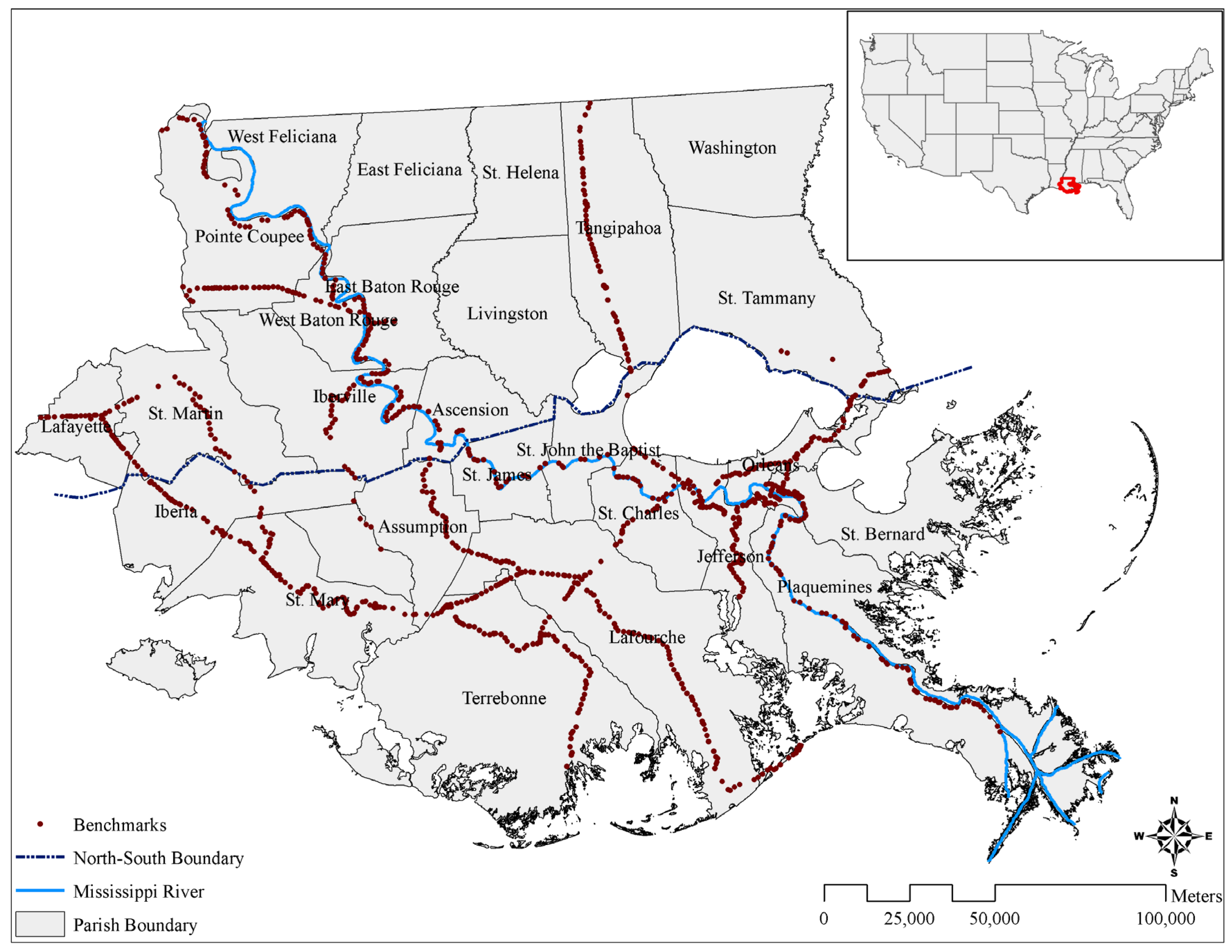
2. Study Area

3. Data and Methods
3.1. Data Sources
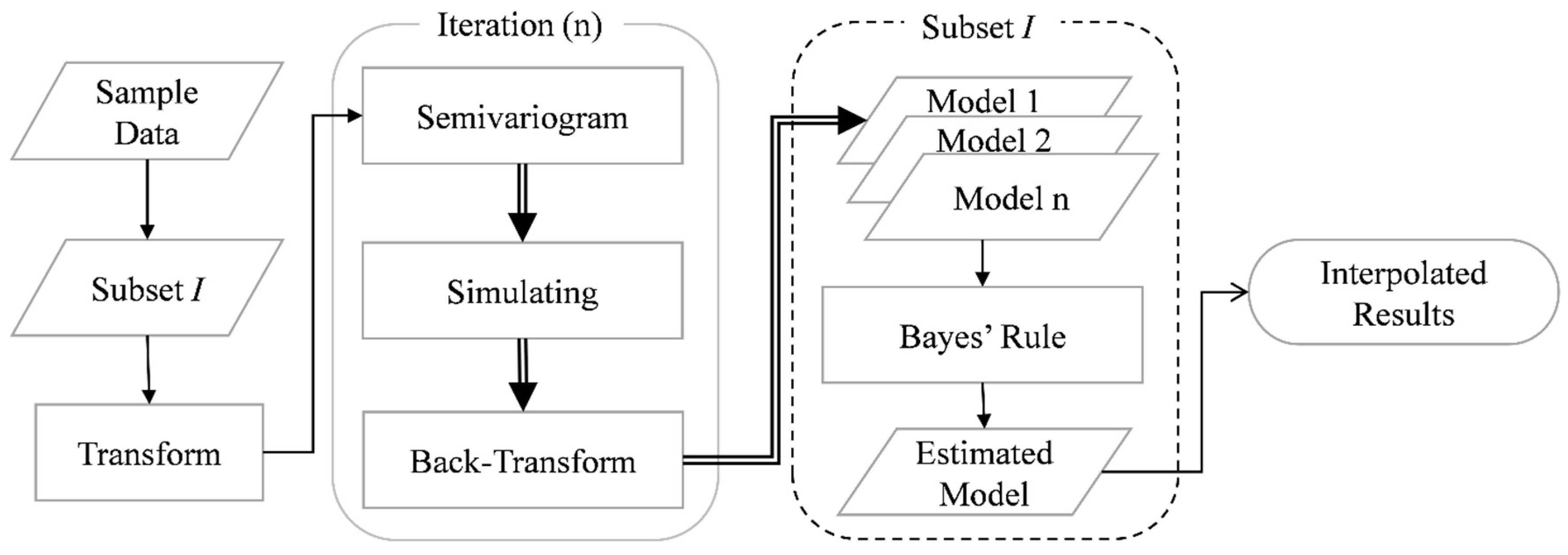
3.2. Empirical Bayesian Kriging

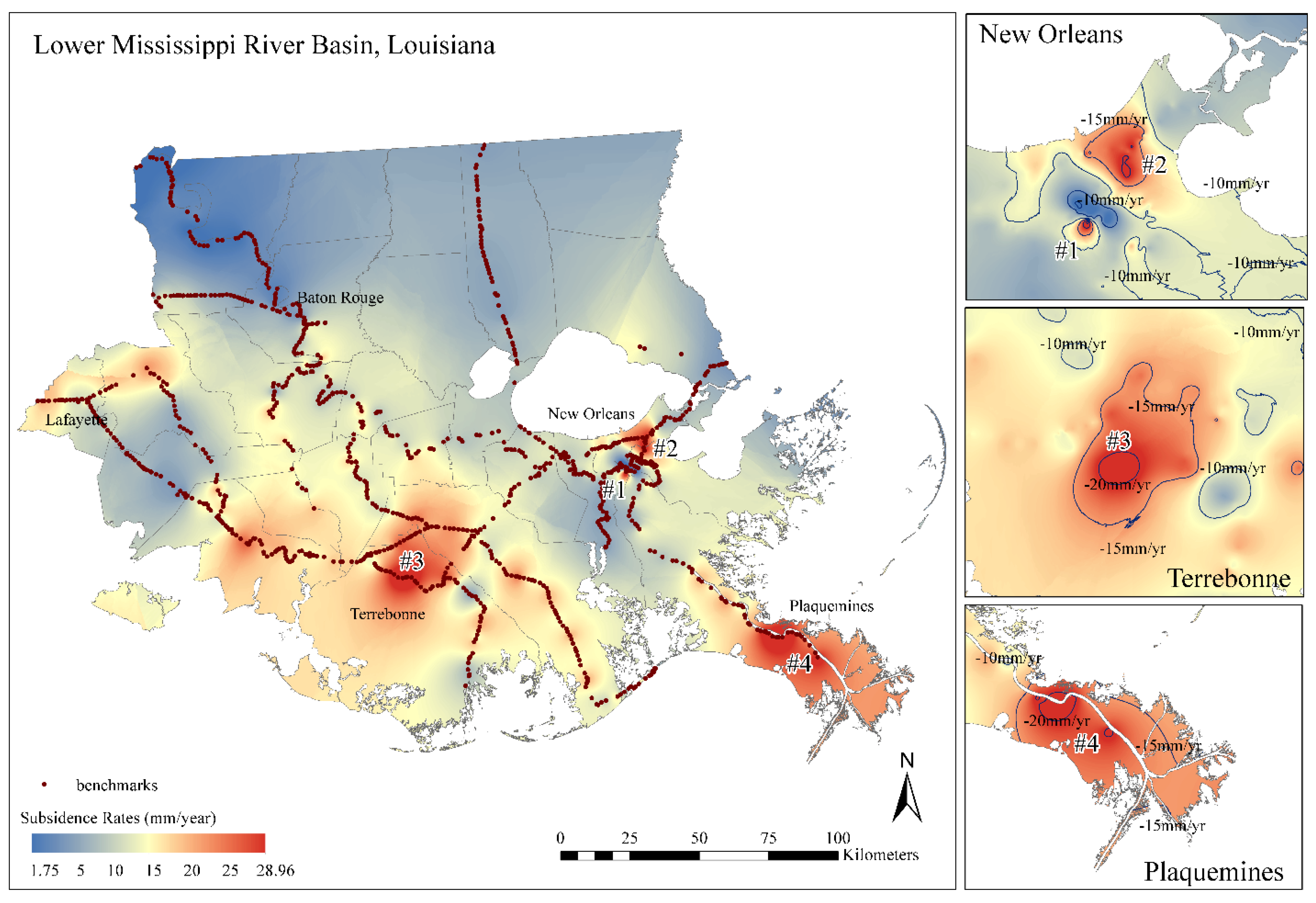
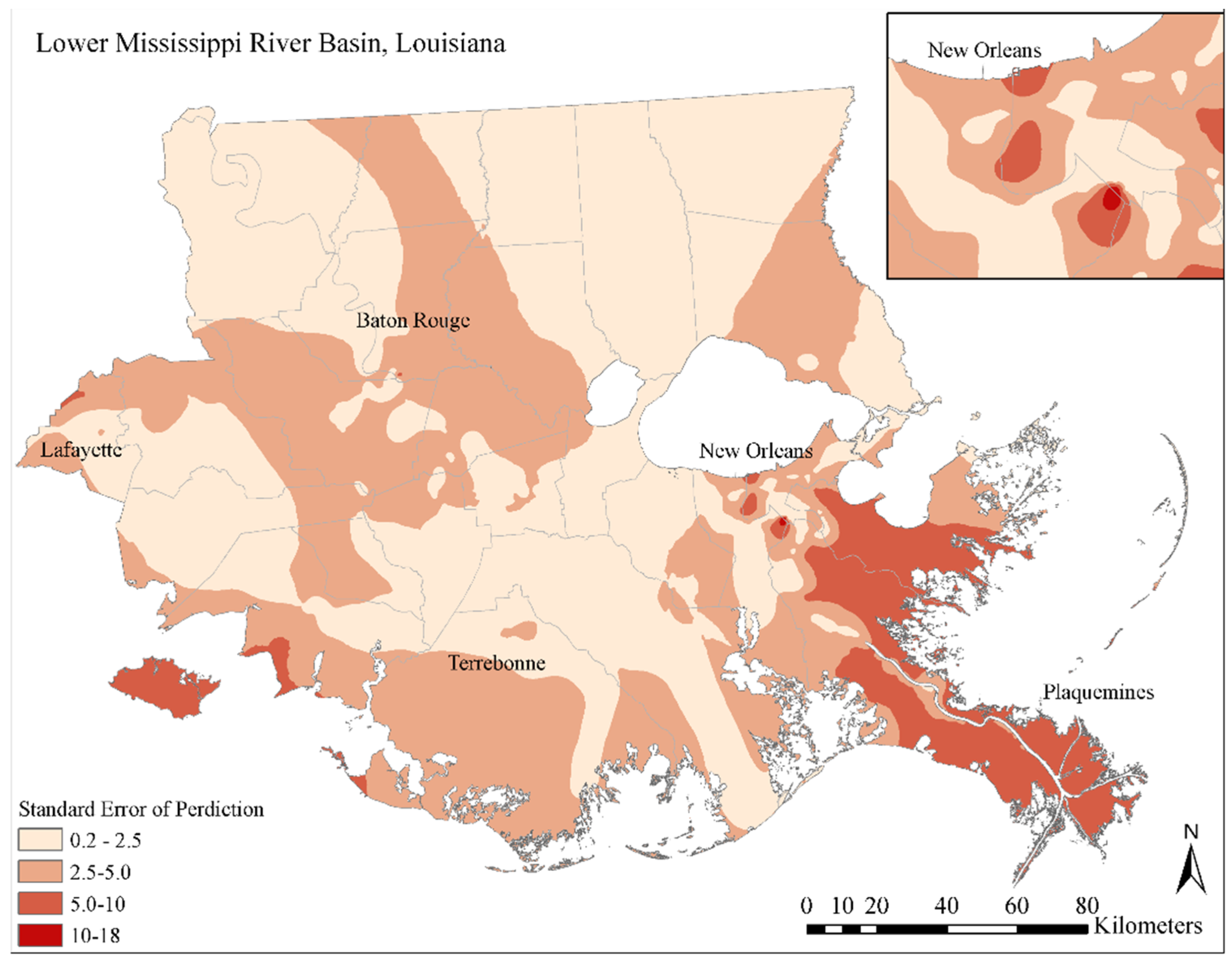
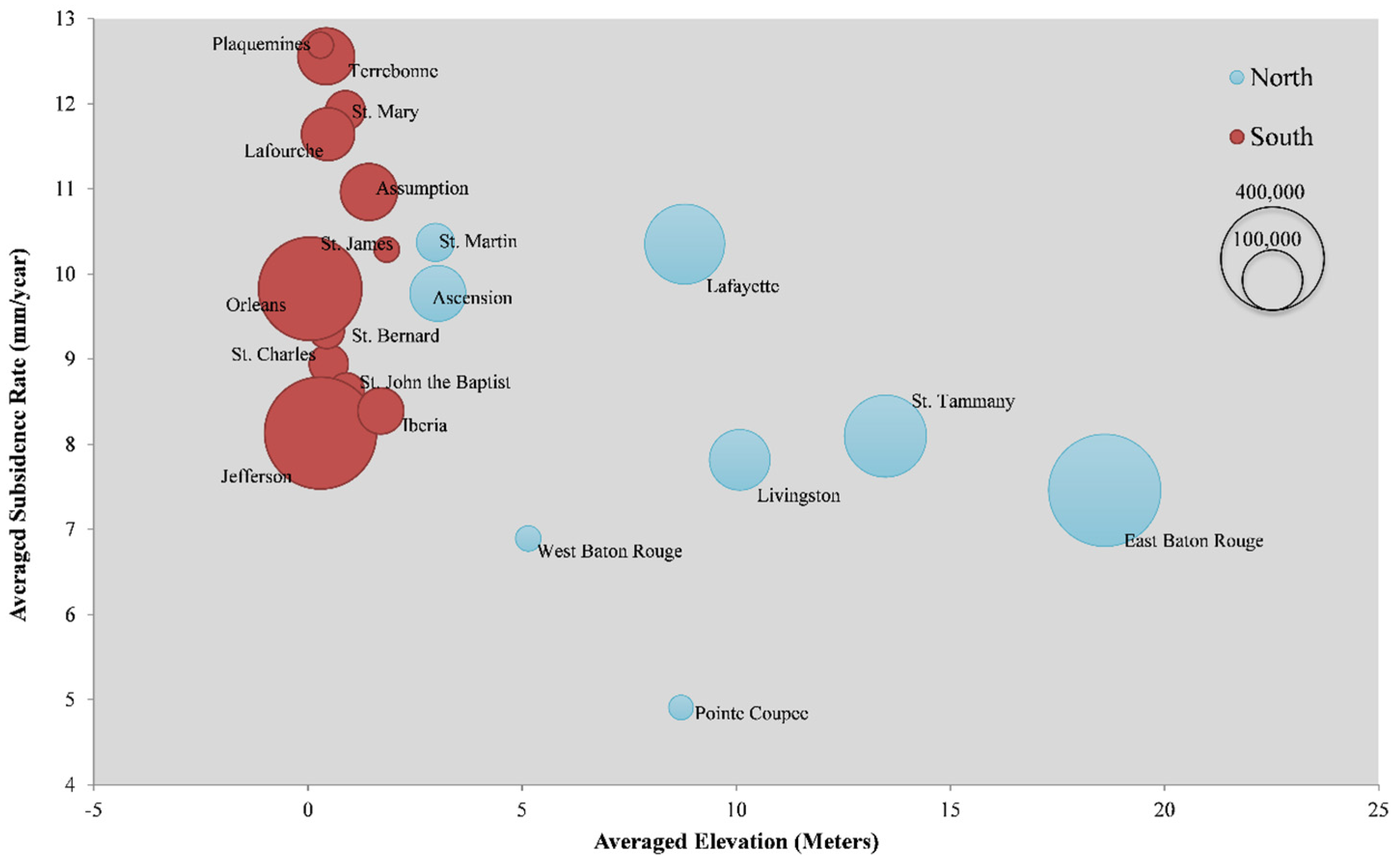
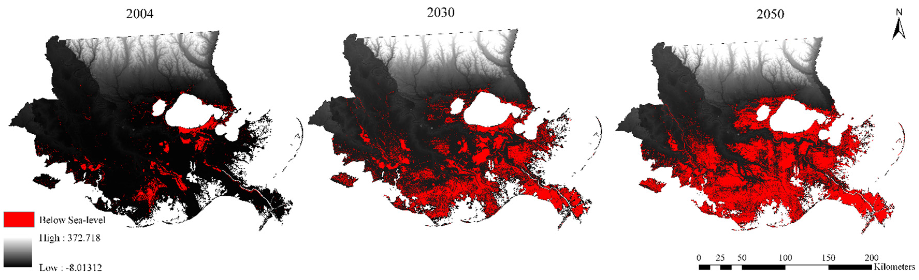
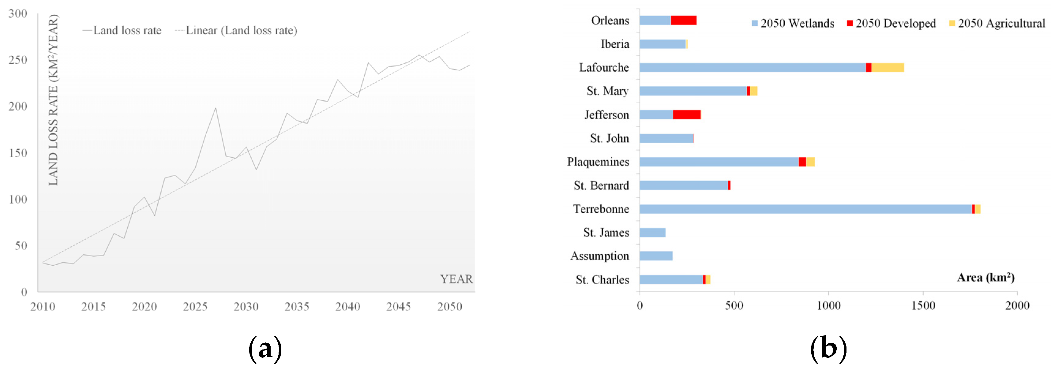
4. Results


| Statistical Area | Min (mm/year) | Max (mm/year) | Average (mm/year) |
|---|---|---|---|
| The North | 1.93 | 16 | 7.55 |
| The South | 1.75 | 28.96 | 11.02 |
| The LMRB | 1.75 | 28.96 | 9.25 |

| Author | Method | Period | Study Region | Rates | Ordinary Kriging | Empirical Bayesian Kriging (Our Results) |
|---|---|---|---|---|---|---|
| Boesch et al., 1983 [15] | Tide gauge | 1970–1980 | Wetlands along Gulf of Mexico | mean = 10 | 8.04–17.19, mean = 12 | 5.76–14.38, mean = 11.2 |
| Mississippi River Delta | max = 40 | 11.11–22.48, max = 22.48 | 12.4–24, max = 24 | |||
| Roberts et al., 1994 [25] | Drill | 1990–1993 | Southern Terrebonne and St. Mary | 0.43–4.29 | 8.73–16.58 | 7.72–12 |
| Dixon, et al., 2006 [8] | RADARSAT monitoring | 2002–2005 | New Orleans City | 10.3–28.6, mean = 8 | 3.03–20.35, mean = 10.9 | 1.75–28.96, mean = 10.7 |
| Lane et al., 2006 [40] | Elevation monitoring stations | 1996–2000 | Caernarvon wetlands | 5.9–12.1 | 8.32–11.65 | 9.52–10.45 |
| West Point A La Hache wetlands | 5.4–12.7 | 10.56–13.60 | 9.66–14.31 | |||
| Violet wetlands | 15.4–27.8 | 11.08–15.60 | 10.2–16.57 | |||
| Mallman & Zoback, 2007 [36] | Numerical modeling | 1982–1993 | Southern Lafourche | 5–10 | 7.48–15.52 | 5.76–16.7 |
| Peyronnin et al., 2013 [35] | Literature and experts panel | Current and near future | Mississippi River Delta | 15–35 | 11.11–22.48 | 12.4–24 |
| Wetlands along Gulf of Mexico | 6–20 | 8.04–17.19 | 5.76–14.38 | |||
| New Orleans City | 2–35 | 3.03–20.35 | 1.75–28.96 |
5. Discussion


6. Conclusions
Acknowledgments
Author Contributions
Conflicts of Interest
References
- Chan, A.W.; Zoback, M.D. The role of hydrocarbon production on land subsidence and fault reactivation in the Louisiana coastal zone. J. Coast. Res. 2007, 23, 771–786. [Google Scholar] [CrossRef]
- Couvillion, B.R.; Barras, J.A.; Steyer, G.D.; Sleavin, W.; Fischer, M.; Beck, H.; Trahan, N.; Griffin, B.; Heckman, D. Land area change in coastal Louisiana from 1932 to 2010. In U.S. Geological Survey Scientific Investigations Map 3164; scale 1:265,000; US Geological Survey: Reston, VA, USA, 2011; pp. 1–19. [Google Scholar]
- Boesch, D.F.; Josselyn, M.N.; Mehta, A.J.; Morris, J.T.; Nuttle, W.K.; Simenstad, C.A.; Swift, D.J.P. Scientific assessment of coastal wetland loss, restoration and management in Louisiana. J. Coast. Res. 1994, 20, i-v, 1–103. [Google Scholar]
- Morton, R.A.; Bernier, J.C. Recent subsidence-rate reductions in the Mississippi delta and their geological implications. J. Coast. Res. 2010, 263, 555–561. [Google Scholar] [CrossRef]
- Penland, S.; Ramsey, K.E. Relative sea-level rise in Louisiana and the Gulf of Mexico: 1908–1988. J. Coast. Res. 1990, 6, 323–342. [Google Scholar]
- Shinkle, K.D.; Dokka, R.K. NOAA Technical Report 50: Rates of Vertical Displacement at Benchmarks in the Lower Mississippi Valley and the Northern Gulf Coast; National Oceanic and Atmospheric Administration, National Geodetic Survey: Sliver Spring, MD, USA, 2004. [Google Scholar]
- Meckel, T.A. An attempt to reconcile subsidence rates determined from various techniques in southern Louisiana. Quat. Sci. Rev. 2008, 27, 1517–1522. [Google Scholar] [CrossRef]
- Dixon, T.H.; Amelung, F.; Ferretti, A.; Novali, F.; Rocca, F.; Dokka, R.; Sella, G.; Kim, S.-W.; Wdowinski, S.; Whitman, D. Space geodesy: Subsidence and flooding in New Orleans. Nature 2006, 441, 587–588. [Google Scholar] [CrossRef] [PubMed]
- Yuill, B.; Lavoie, D.; Reed, D.J. Understanding subsidence processes in coastal Louisiana. J. Coast. Res. 2009, 10054, 23–36. [Google Scholar] [CrossRef]
- Xu, Y.J.; Viosca, A. Surface water assessment of three Louisiana watersheds. Watershed Update 2005, 3, 1–8. [Google Scholar]
- Lam, N.S.N.; Arenas, H.; Pace, K.; LeSage, J.; Campanella, R. Predictors of business return in New Orleans after hurricane Katrina. PLoS ONE 2012, 7. [Google Scholar] [CrossRef] [PubMed]
- Grinsted, A.; Moore, J.C.; Jevrejeva, S. Projected Atlantic hurricane surge threat from rising temperatures. Proc. Natl. Acad. Sci. USA 2013, 110, 5369–5373. [Google Scholar] [CrossRef] [PubMed]
- Reed, D.J.; Cahoon, D. Marsh Submergence vs. Marsh Accretion: Interpreting Accretion Deficit Data in Coastal Louisiana. In Proceedings of the 8th Symposium on Coastal and Ocean Management, New Orleans, LA, USA, 19–23 July 1993; pp. 243–257.
- Britsch, L.D.; Dunbar, J.B. Land loss rates: Louisiana coastal plain. J. Coast. Res. 1993, 9, 324–338. [Google Scholar]
- Roberts, H.H.; Bailey, A.; Kuecher, G.J. Subsidence in the Mississippi river delta—Important influences of valley filling by cyclic deposition, primary consolidation phenomena, and early diagenesis. Gulf Coast Assoc. Geol. Soc. Trans. 1994, 41, 619–629. [Google Scholar]
- Penland, S.; Boyd, R.; Suter, J.R. Transgressive depositional systems of the Mississippi delta plain: A model for barrier shoreline and shelf sand development. J. Sediment. Res. 1988, 58, 932–949. [Google Scholar]
- Penland, S.; Suter, J.R. The geomorphology of the Mississippi River chenier plain. Mar. Geol. 1989, 90, 231–258. [Google Scholar] [CrossRef]
- Ramsey, K.E.; Moslow, T.F. A numerical analysis of subsidence in Louisiana and the Gulf of Mexico. Gulf Coast Assoc. Geol. Soc. Trans. 1987, 39, 491–500. [Google Scholar]
- Kent, J.; Dokka, R. Potential impacts of long-term subsidence on the wetlands and evacuation routes in coastal Louisiana. GeoJournal 2013, 78, 641–655. [Google Scholar] [CrossRef]
- Scardina, A.; Nunn, J.; Pilger, R., Jr. Subsidence and flexure of the lithosphere in the north Louisiana salt basin. EOS Trans. Am. Geophys. Union 1981, 62, 391. [Google Scholar]
- Holzer, T.L.; Bluntzer, R.L. Land subsidence near oil and gas fields, Houston, Texas. Ground Water 1984, 22, 450–459. [Google Scholar] [CrossRef]
- Kooi, H.; de Vries, J.J. Land subsidence and hydrodynamic compaction of sedimentary basins. Hydrol. Earth Syst. Sci. 1998, 2, 159–171. [Google Scholar] [CrossRef]
- Gagliano, S.M.; Kemp, E.B.; Wicker, K.M.; Wiltenmuth, K.S.; Sabate, R.W. Neo-tectonic framework of southeast Louisiana and applications to coastal restoration. Gulf Coast Assoc. Geol. Soc. Trans. 2003, 53, 262–276. [Google Scholar]
- Morton, R.A.; Bernier, J.C.; Barras, J.A.; Ferina, N.F. Rapid Subsidence and Historical Wetland Loss in the Mississippi Delta Plain: Likely Causes and Future Implications; 2005–1216; U.S. Geological Survey (USGS): Reston, VA, USA, 2005.
- Mallman, E.P.; Zoback, M.D. Subsidence in the Louisiana coastal zone due to hydrocarbon production. J. Coast. Res. 2007, 23, 443–449. [Google Scholar]
- Qiang, Y.; Lam, N.N. Modeling land use and land cover changes in a vulnerable coastal region using artificial neural networks and cellular automata. Environ. Monit. Assess. 2015, 187, 1–16. [Google Scholar] [CrossRef] [PubMed]
- Anderson, J.R.; Hardy, E.E.; Roach, J.T.; Witmer, R.E. A Land Use and Land Cover Classification System for Use with Remote Sensor Data; Professional Paper 964; US Government Printing Office: Washington, DC, USA, 1976.
- Oliver, M.A.; Webster, R. Kriging: A method of interpolation for geographical information systems. Int. J. Geogr. Inf. Syst. 1990, 4, 313–332. [Google Scholar] [CrossRef]
- Chang, K.-T. Introduction to Geographic Information Systems, 6th ed.; McGraw-Hill Higher Education: Boston, MA, USA, 2006; pp. 324–332. [Google Scholar]
- Cressie, N. Spatial prediction and ordinary kriging. Math Geol. 1988, 20, 405–421. [Google Scholar] [CrossRef]
- Lam, N.S.-N. Spatial interpolation methods: A review. Am. Cartogr. 1983, 10, 129–150. [Google Scholar] [CrossRef]
- Pilz, J.; Spöck, G. Why do we need and how should we implement Bayesian Kriging methods. Stoch. Environ. Res. Risk Assess. 2008, 22, 621–632. [Google Scholar] [CrossRef]
- Krivoruchko, K. Empirical bayesian kriging: Implemented in ArcGIS geostatistical analyst. ArcUser 2012, 6–10. Available online: http://www.esri.com/news/arcuser/1012/files/ebk.pdf (accessed on 18 December 2015). [Google Scholar]
- Nelson, F.; Hinkel, K.; Shiklomanov, N.; Mueller, G.; Miller, L.; Walker, D. Active-layer thickness in north central Alaska: Systematic sampling, scale, and spatial autocorrelation. J. Geophys. Res. 1998, 103, 28963–28973. [Google Scholar] [CrossRef]
- Peyronnin, N.; Green, M.; Richards, C.P.; Owens, A.; Reed, D.; Chamberlain, J.; Groves, D.G.; Rhinehart, W.K.; Belhadjali, K. Louisiana’s 2012 coastal master plan: Overview of a science-based and publicly informed decision-making process. J. Coast. Res. 2013, 67, 1–15. [Google Scholar] [CrossRef]
- Boesch, D.F.; Levin, D.; Nummedal, D.; Bowles, K. Subsidence in Coastal Louisiana: Causes, Rates, and Effects on Wetlands; U.S. Fish and Wildlife Service, Division of Biological Services: Washington, DC, USA, 1983. [Google Scholar]
- Burkett, V.R.; Zilkoski, D.B.; Hart, D.A. Sea-Level Rise and Subsidence: Implications for Flooding in New Orleans, Louisiana, U.S. In Proceedings of the Geological Survey Subsidence Interest Group Conference: Proceedings of the Technical Meeting, Galveston, TX, USA, 27–29 November 2001; U.S. Geological Survey: Reston, VA, USA, 2003; pp. 63–70. [Google Scholar]
- Morton, R.A.; Buster, N.A.; Krohn, M.D. Subsurface controls on historical subsidence rates and associated wetland loss in South-central Louisiana. Gulf Coast Assoc. Geol. Soc. Trans. 2002, 52, 767–778. [Google Scholar]
- Ivins, E.R.; Dokka, R.K.; Blom, R.G. Post-glacial sediment load and subsidence in coastal Louisiana. Geophys. Res. Lett. 2007, 34. [Google Scholar] [CrossRef]
- Lane, R.R.; Day, J.M.; Day, J.N. Wetland surface elevation, vertical accretion, and subsidence at three Louisiana estuaries receiving diverted Mississippi River water. Wetlands 2006, 4, 1130–1142. [Google Scholar] [CrossRef]
- Gagliano, S.M. Effects of Natural Fault Movement on Land Subsidence in Coastal Louisiana. In Proceedings of the 14th Biennial Coastal Zone Conference, New Orleans, LA, USA, 17–21 July 2005.
- Kuecher, G.J.; Roberts, H.H.; Thompson, M.D.; Matthews, I. Evidence for active growth faulting in the Terrebonne delta plain, south Louisiana: Implications for wetland loss and the vertical migration of petroleum. Environ. Geosci. 2001, 8, 77–94. [Google Scholar] [CrossRef]
- Diegel, F.A.; Karlo, J.F.; Shoup, R.C.; Schuster, D.C. Cenozoic structural evolution and tectono-stratigraphic framework of the northern gulf coast continental margin. AAPG Memoir 1996, 65, 109–151. [Google Scholar]
- Lopez, J.; Penland, S.; Williams, J. Confirmation of active geologic faults in Lake Pontchartrain in southeast Louisiana. Gulf Coast Assoc. Geol. Soc. Trans. 1997, 47, 299–303. [Google Scholar]
- Dokka, R.K. Modern-day tectonic subsidence in coastal louisiana. Geology 2006, 34, 281–284. [Google Scholar] [CrossRef]
- Coastal Wetlands Planning Protection and Restoration Act (CWPPRA). The Mississippi River Delta Basin; USGS National Wetlands Research Center: Lafayette, LA, USA, 1999.
- Coleman, J.; Roberts, H.H. Deltaic coastal wetlands. In Coastal Lowlands: Geology and Geotechnology; van der Linden, W.J.M., Cloetingh, S.A.P.L., Kaasschieter, J.P.K., van de Graaff, W.J.E., Vandenberghe, J., van der Gun, J.A.M., Eds.; Springer Netherlands: Dordrecht, The Netherlands, 1989; pp. 1–24. [Google Scholar]
- Morton, R.A.; Tiling, G.; Ferina, N.F. Primary Causes of Wetland Loss at Madison Bay, Terrebonne Parish, Louisiana; 03-60; USGS, Center for Coastal and Watershed Studies: St. Petersburg, FL, USA, 2003.
- Plaquemines Parish Comprehensive Master Plan. Coastal Protection and Restoration. In Community Assessment-Technical Addendum, Coastal Protection and Restoration; Plaquemines Parish Government: Plaquemines Parish, LA, USA, 2015; pp. 1–16. [Google Scholar]
- Smith, R.D.; Ammann, A.; Bartoldus, C.; Brinson, M.M. An Approach for Assessing Wetland Functions Using Hydrogeomorphic Classification, Reference Wetlands, and Functional Indices; Army Engineer Waterways Experiment Station: Vicksburg, MS, USA, 1995. [Google Scholar]
- Coastal Protection & Restoration Authority of Louisiana (CPRA). Louisiana’s Comprehensive Master Plan for a Sustainable Coast; Coastal Protection and Restoration Authority of Louisiana: Baton Rouge, LA, USA, 2012. [Google Scholar]
- González, J.L.; Tornqvist, T.E. Coastal Louisiana in crisis: Subsidence or sea level rise? Eos Trans. Am. Geophys. Union 2006, 87, 493–498. [Google Scholar] [CrossRef]
- Meckel, T.A.; ten Brink, U.S.; Williams, S.J. Current subsidence rates due to compaction of holocene sediments in southern Louisiana. Geophys. Res. Lett. 2006, 33. [Google Scholar] [CrossRef]
© 2015 by the authors; licensee MDPI, Basel, Switzerland. This article is an open access article distributed under the terms and conditions of the Creative Commons by Attribution (CC-BY) license (http://creativecommons.org/licenses/by/4.0/).
Share and Cite
Zou, L.; Kent, J.; Lam, N.S.-N.; Cai, H.; Qiang, Y.; Li, K. Evaluating Land Subsidence Rates and Their Implications for Land Loss in the Lower Mississippi River Basin. Water 2016, 8, 10. https://doi.org/10.3390/w8010010
Zou L, Kent J, Lam NS-N, Cai H, Qiang Y, Li K. Evaluating Land Subsidence Rates and Their Implications for Land Loss in the Lower Mississippi River Basin. Water. 2016; 8(1):10. https://doi.org/10.3390/w8010010
Chicago/Turabian StyleZou, Lei, Joshua Kent, Nina S.-N. Lam, Heng Cai, Yi Qiang, and Kenan Li. 2016. "Evaluating Land Subsidence Rates and Their Implications for Land Loss in the Lower Mississippi River Basin" Water 8, no. 1: 10. https://doi.org/10.3390/w8010010
APA StyleZou, L., Kent, J., Lam, N. S.-N., Cai, H., Qiang, Y., & Li, K. (2016). Evaluating Land Subsidence Rates and Their Implications for Land Loss in the Lower Mississippi River Basin. Water, 8(1), 10. https://doi.org/10.3390/w8010010