Spatial and Temporal Variability of Bank Erosion during the Period 1930–2016: Case Study—Kolubara River Basin (Serbia)

 ,
,
Abstract
:1. Introduction
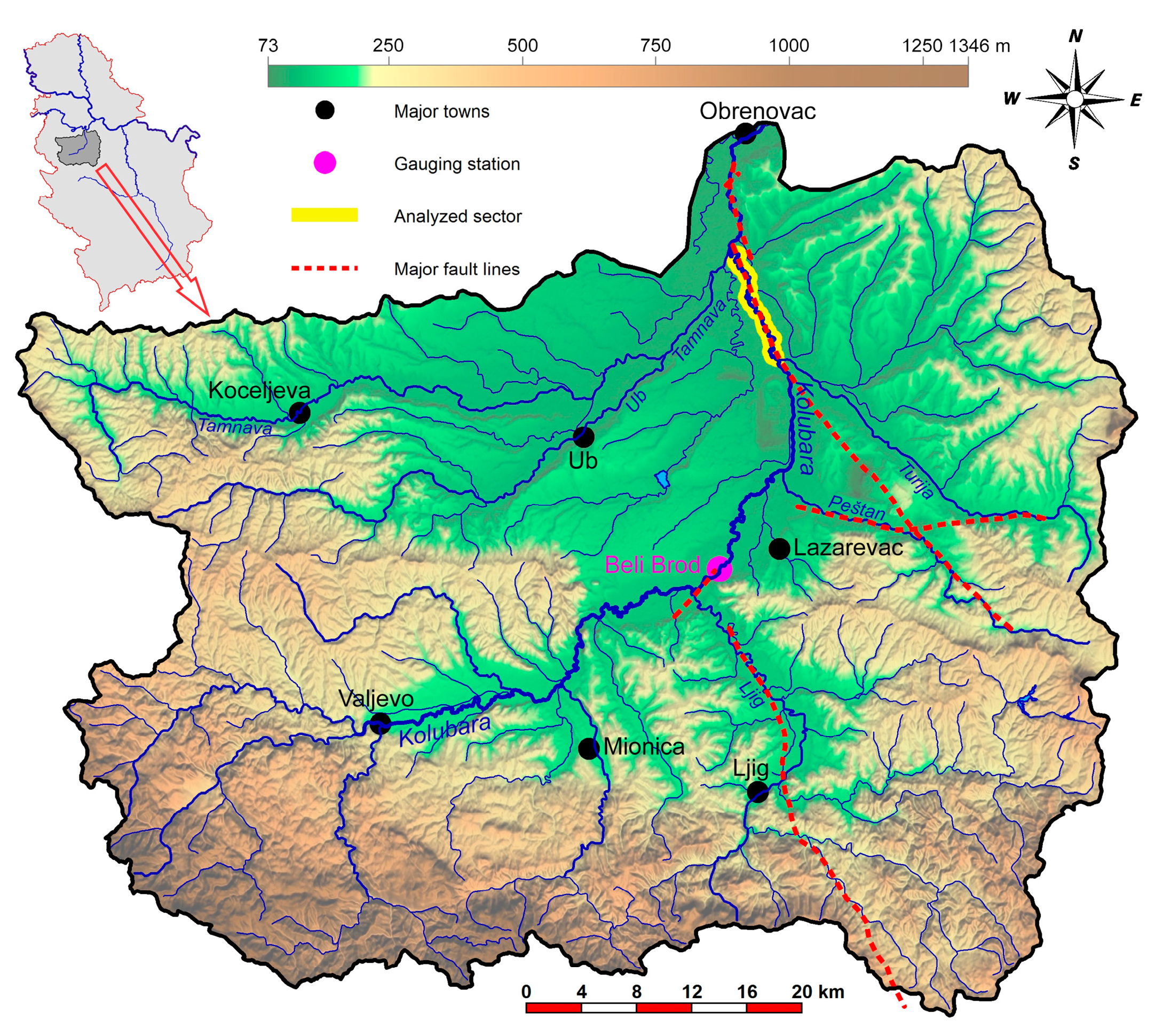
2. Study Area
3. Materials and Methods
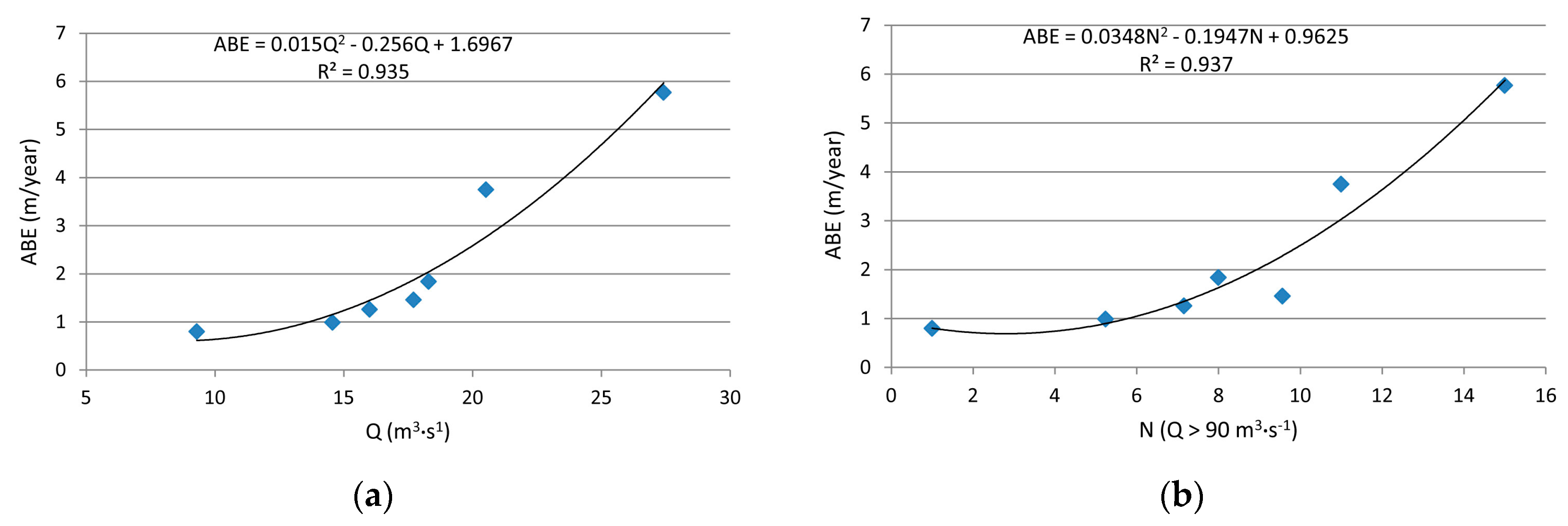
4. Results
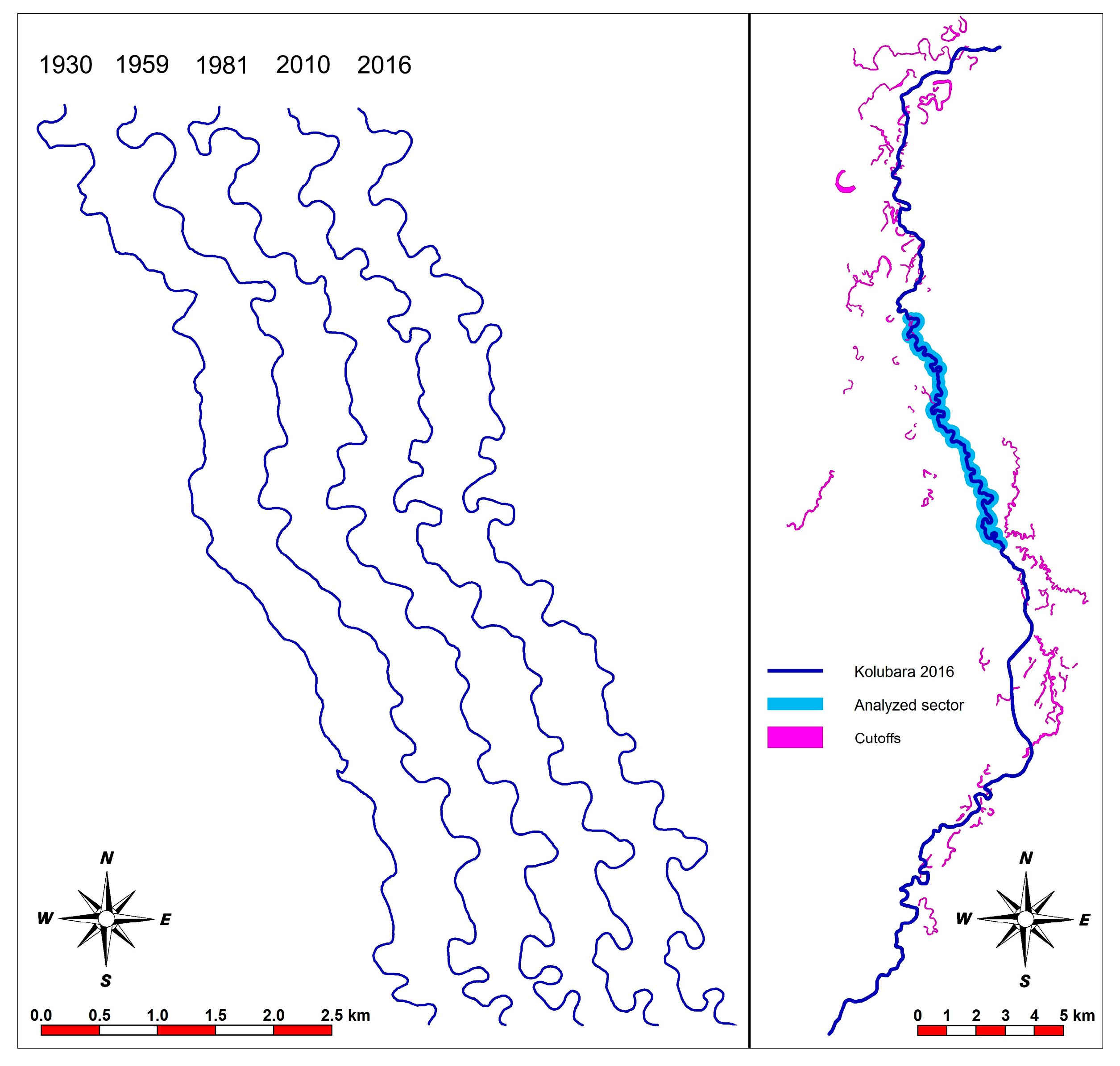
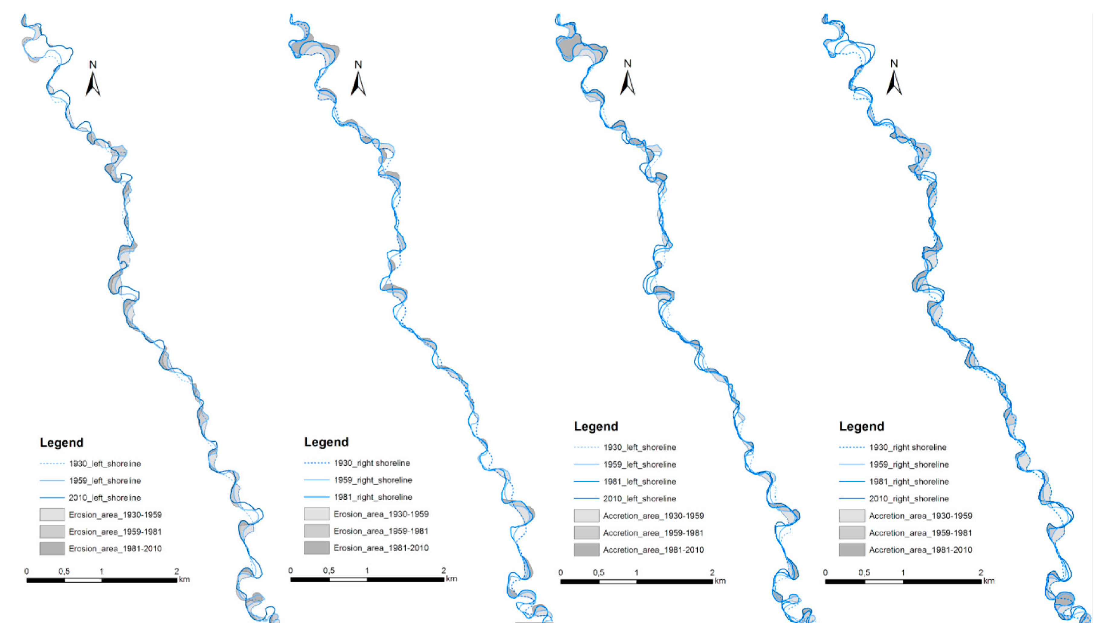
4.1. Long-Term Bank Erosion (1930–2010)
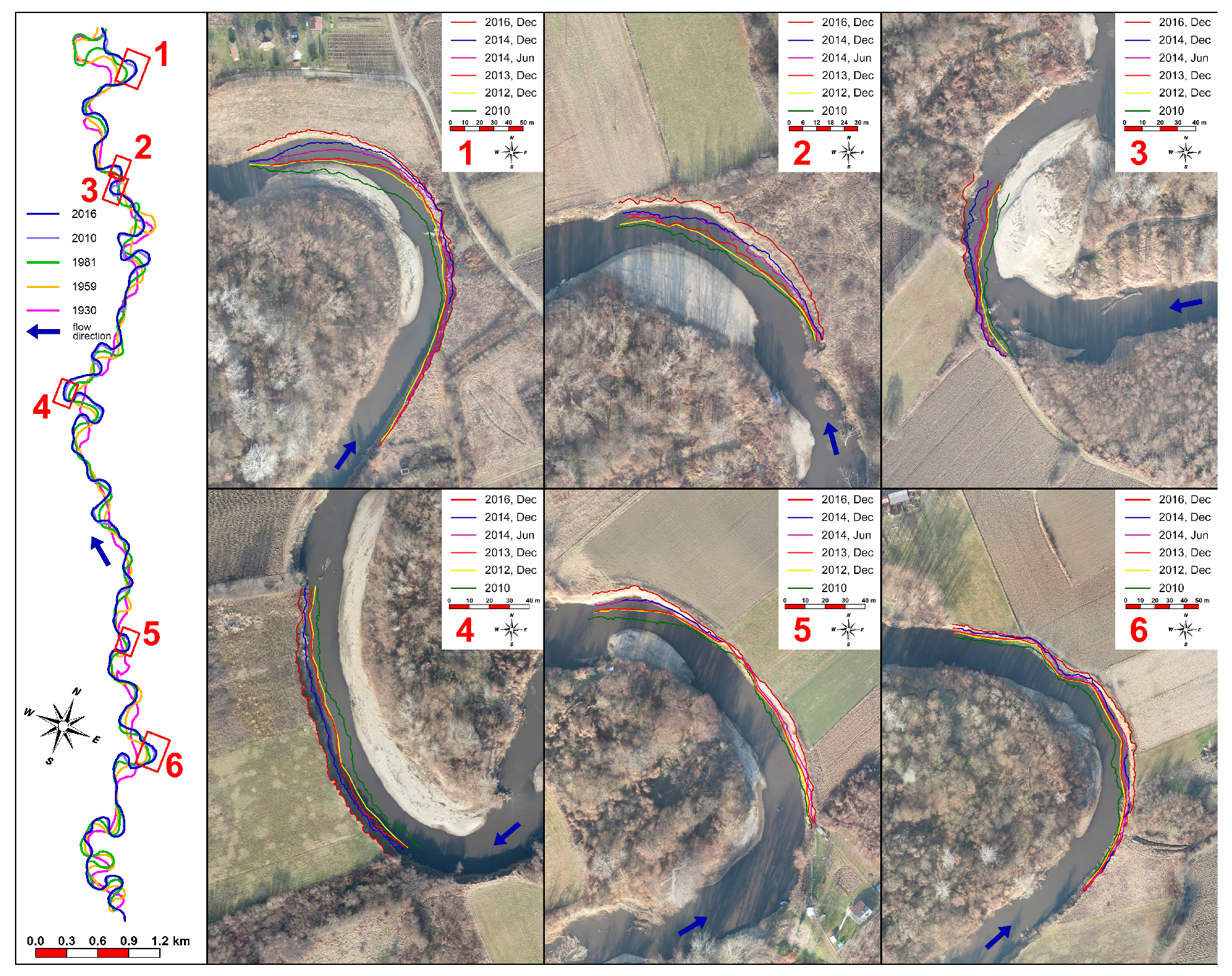
4.2. Short-Term Active Bank Erosion (2010–2016)
5. Discussion
6. Conclusions
Acknowledgments
Author Contributions
Conflicts of Interest
References
- Hooke, J.M. Spatial variability, mechanisms and propagation of change in an active meandering river. Geomorphology 2007, 84, 277–296. [Google Scholar] [CrossRef]
- Knighton, D. Fluvial Forms and Processes—A New Perspective, 1st ed.; Arnold: London, UK, 1998; p. 383. ISBN 034066313. [Google Scholar]
- Petrovszki, J.; Székely, B.; Timár, G. A systematic overview of the coincidences of river sinuosity changes and tectonically active structures in the Pannonian Basin. Glob. Planet. Chang. 2012, 98–99, 109–121. [Google Scholar] [CrossRef]
- Petrovszki, J.; Timár, G.; Molnár, G. Is sinuosity a function of slope and bankfull discharge?—A case study of the meandering rivers in the Pannonian Basin. Hydrol. Earth Syst. Sci. Discuss. 2014, 11, 12271–12290. [Google Scholar] [CrossRef]
- Blanka, V.; Kiss, T. Effect of different water stages on bank erosion, case study of river Hernad, Hungary. Carpathian J. Earth Environ. Sci. 2011, 6, 101–108. [Google Scholar]
- Zaimes, G.N.; Schultz, R.C.; Isenhart, T.M. Stream bank erosion adjacent to riparian forest buffers, row-crop fields, and continuously-grazed pastures along Bear Creek in central Iowa. J. Soil Water Conserv. 2004, 59, 19–27. [Google Scholar]
- Surian, N.; Rinaldi, M. Morphological response to river engineering and management in alluvial channels in Italy. Geomorphology 2003, 50, 307–326. [Google Scholar] [CrossRef]
- James, L.A.; Marcus, W.A. The human role in changing fluvial systems: Retrospect, inventory and prospect. Geomorphology 2006, 79, 152–171. [Google Scholar] [CrossRef]
- Hooke, J.M. Human impacts on fluvial systems in the Mediterranean region. Geomorphology 2006, 79, 311–335. [Google Scholar] [CrossRef]
- Kiss, T.; Fiala, K.; Sipos, G. Alterations of channel parameters in response to river regulation works since 1840 on the Lower Tisza River (Hungary). Geomorphology 2008, 98, 96–110. [Google Scholar] [CrossRef]
- Vandenberghe, J.; de Moor, J.J.W.; Spanjaard, G. Natural change and human impact in a present-day fluvial catchment: The Geul River, Southern Netherlands. Geomorphology 2012, 159, 1–14. [Google Scholar] [CrossRef]
- Kiss, T.; Blanka, V. River channel response to climate- and human-induced hydrological changes: Case study on the meandering Hernád River, Hungary. Geomorphology 2012, 175–176, 115–125. [Google Scholar] [CrossRef]
- Popov, D.; Marković, S.; Štrbac, D. Generations of meanders in Serbian part of Tisa valley. J. Geogr. Inst. Cvijic 2008, 58, 29–42. [Google Scholar] [CrossRef]
- Dragićević, S.; Tošić, R.; Stepić, M.; Živković, N.; Novković, I. Consequences of the River Bank Erosion in the Southern Part of the Pannonian Basin: Case study—Serbia and the Republic of Srpska. Forum Geogr. 2013, 12, 5–15. [Google Scholar] [CrossRef]
- Tošić, R.; Lovrić, N.; Dragićević, S. Land use changes caused by bank erosion along the lower part of the Bosna River from 2001 to 2013. Bull. Serbian Geogr. Soc. 2014, 94, 49–58. [Google Scholar] [CrossRef]
- Lovric, N.; Tosic, R. Assessment of bank erosion, accretion and lateral channel migration using remote sensing and GIS: Case study—Lower part of the Bosna River. Quaest. Geogr. 2016, 35, 81–92. [Google Scholar] [CrossRef]
- Rădoane, M.; Rădoane, N.; Dumitriu, D. Geomorphological evolution of longitudinal river profiles in the Carpathians. Geomorphology 2003, 50, 293–306. [Google Scholar] [CrossRef]
- Rădoane, M.; Pandi, G.; Rădoane, N. Contemporary bed elevation changes from the eastern Carpathians. Carpathian J. Earth Environ. Sci. 2010, 5, 49–60. [Google Scholar]
- Rădoane, M.; Obreja, F.; Cristea, I.; Mihailă, D. Changes in the channel-bed level of the eastern Carpathian rivers: Climatic vs. human control over the last 50 years. Geomorphology 2013, 193, 91–111. [Google Scholar] [CrossRef]
- Floriou, I. Types of riverbed along the lower course of the Buzau River. Forum Geogr. 2011, 10, 91–98. [Google Scholar] [CrossRef]
- Perşoiu, I.; Rădoane, M. Spatial and temporal controls on historical channel responses—Study of an atypical case: Someşu Mic River, Romania. Earth Surf. Process. Landf. 2011, 36, 1391–1409. [Google Scholar] [CrossRef]
- Petkovic, S.; Petkovic-Obratov, D. Harmonization of the engineering and environmental objectives of the river management—Case study of the Južna Morava river. Bull. Fac. For. 2001, 92, 125–148. [Google Scholar] [CrossRef]
- Petkovic, S.; Malesev, M.; Krunic, B.; Damjanovic, V. River management based on harmonization of principal goals of river training. Water Sanit. Technol. 2013, 43, 17–24. [Google Scholar]
- Dragicevic, S.; Zivkovic, N.; Roksandic, M.; Kostadinov, S.; Novkovic, I.; Tosic, R.; Stepic, M.; Dragicevic, M.; Blagojevic, B. Land use changes and environmental problems caused by bank erosion: A case study of the Kolubara River Basin in Serbia. In Environmental Land Use Planning, 1st ed.; Appiah-Opoku, S., Ed.; InTech: Rijeka, Croatia, 2012; pp. 3–20. ISBN 978-953-51-0832-0. [Google Scholar] [CrossRef]
- Dragicevic, S.; Stojanovic, Z.; Manic, E.; Roksandic, M.; Stepic, M.; Zivkovic, N.; Zlatic, M.; Kostadinov, S. Economic consequences of bank erosion in the lower part of the Kolubara River Basin, Serbia. Environ. Eng. Manag. J. 2017, 16, 381–390. [Google Scholar]
- Roksandic, M.; Dragicevic, S.; Zivkovic, N.; Kostadinov, S.; Zlatic, M.; Martinovic, M. Bank erosion as a factor of soil loss and land use changes in the Kolubara River Basin, Serbia. Afr. J. Agric. Res. 2011, 6, 6604–6608. [Google Scholar] [CrossRef]
- Dragićević, S.; Živković, N.; Kostadinov, S. Changes of hydrological system in the lower course of the Kolubara River. In Floods, Morphological Processes, Erosion, Sediment Transport and Sedimentation, Proceedings of the XXIV Conference of the Danubian Countries on the Hydrological Forecasting and Hydrological Bases of Water Management, Bled, Slovenia, 2–4 June 2008; Mitja, B., Mojca, Š., Eds.; Slovenian National Committee for the IHP UNESCO: Ljubljana, Slovenia, 2008; Volume 5, p. 186. ISBN 978-961-91090-3-8. [Google Scholar]
- Dragićević, S.; Živković, N.; Roksandić, M.; Luković, J.; Kostadinov, S. Recent State, Intensity and Consequences of Degradation of the Riverbanks of Kolubara in the Territory of Obrenovac Municipality, 1st ed.; Faculty of Geography, University of Belgrade: Beograd, Serbia, 2015; p. 266. ISBN 978-86-6283-028-9. (In Serbian with Summary in English). [Google Scholar]
- Manojlović, P.; Dragićević, S.; Mustafić, S. The basic morphometric characteristics of Serbian relief. Bull. Serbian Geogr. Soc. 2004, 84, 11–20. [Google Scholar] [CrossRef]
- Bada, G.; Horváth, F.; Dövényi, P.; Szafián, P.; Windhoffer, G.; Cloetingh, S. Present-day stress field and tectonic inversion in the Pannonian basin. Glob. Planet. Chang. 2007, 58, 165–180. [Google Scholar] [CrossRef]
- Ćalić, J.; Gaudenyi, T.; Milošević, M.V.; Štrbac, D.; Milivojević, M. Geomorphometrical method for delineation of plains—Case study of the South-Eastern (Serbian) segment of the Pannonian Plain. Carpathian J. Earth Environ. Sci. 2012, 7, 239–248. [Google Scholar]
- Ćalić, J.; Milošević, V.M.; Gaudenyi, T.; Štrbac, D.; Milivojević, M. Pannonian Plain as a morphostructural unit of Serbia. Bull. Serbian Geogr. Soc. 2012, 92, 47–70. [Google Scholar] [CrossRef]
- Živković, N.; Dragićević, S.; Ristić, R.; Novković, I.; Djurdjić, S.; Luković, J.; Živković, L.; Jovanović, S. Effects of vegetation on runoff in small river basins in Serbia. Fresenius Environ. Bull. 2015, 24, 2082–2089. [Google Scholar]
- Kasvi, E.; Laamanen, L.; Lotsari, E.; Alho, P. Flow patterns and morphological changes in a sandy meander bend during a flood—Spatially and temporally intensive ADCP measurement approach. Water 2017, 9, 106. [Google Scholar] [CrossRef]
- Gu, L.; Zhang, S.; He, L.; Chen, D.; Blanckaert, K.; Ottevanger, W.; Zhang, Y. Modeling flow pattern and evolution of meandering channels with a nonlinear model. Water 2016, 8, 418. [Google Scholar] [CrossRef]
- Dragićević, S.; Živković, N.; Novković, I.; Petrović, A.; Tošić, R.; Milevski, I. Hydrological and suspended sediment regime in the Kolubara River during the extreme year of 2014. Revista de Geomorfologie 2016, 18, 26–38. [Google Scholar]
- Dragićević, S. Dominant Processes of Erosion in the Kolubara River Basin, 1st ed.; Faculty of Geography, University of Belgrade: Belgrad, Serbia, 2007; p. 245. ISBN 978-86-82657-63-7. (In Serbian with Summary in English). [Google Scholar]
- Dragićević, S.; Ristić, R.; Živković, N.; Kostadinov, S.; Tošić, R.; Novković, I.; Borisavljević, A.; Radić, Z. Floods in Serbia in 2010–Case study: The Kolubara and Pcinja River Basins. In Geomorphological Impacts of Extreme Weather: Case Studies from Central and Eastern Europe, 1st ed.; Loczy, D., Ed.; Springer: Dordrecht, The Netherlands, 2013; pp. 155–170. ISBN 978-94-007-6301-2. [Google Scholar] [CrossRef]
- Dragicevic, S.; Carevic, I.; Kostadinov, S.; Novkovic, I.; Abolmasov, B.; Milojkovic, B.; Simic, D. Landslide susceptibility zonation in the Kolubara River Basin (western Serbia)—Analisys of input data. Carpathian J. Earth Environ. Sci. 2012, 7, 37–47. [Google Scholar]
- Dragićević, S. Pluviometric regime and its influence on erosive process in the Kolubara River Basin. Bull. Serbian Geogr. Soc. 2001, 80, 27–36, (In Serbian with Summary in English). [Google Scholar]
- Burić, D.; Stanojević, G.; Luković, J.; Gavrilović, L.; Živković, N. Climate change and river discharge: Case study Kolubara river, Beli Brod hydrological gauge. Bull. Serbian Geogr. Soc. 2012, 92, 123–134. [Google Scholar] [CrossRef]
- Petrović, A.; Dragićević, S.; Radić, B.P.; Milanović Pešić, A.Z. Historical torrential flood events in the Kolubara River Basin. Nat. Hazards 2015, 79, 537–547. [Google Scholar] [CrossRef]
- Republic Hydrometeorological Service of Serbia (RHMOS). Meteorological and Hydrological Annual Reports—Precipitation and Surface Water; RHMOS: Belgrade, Serbia, 2014.
- Lawler, D.M. The measurement of river bank erosion and lateral channel change: A review. Earth Surf. Process. Landf. 1993, 18, 777–821. [Google Scholar] [CrossRef]
- Grove, J.R.; Croke, J.; Thompson, C. Quantifying different riverbank erosion processes during an extreme flood event. Earth Surf. Process. Landf. 2013, 38, 1393–1406. [Google Scholar] [CrossRef]
- Yang, C.; Cai, X.; Wang, X.; Yan, R.; Zhang, T.; Zhang, Q.; Lu, X. Remotely sensed trajectory analysis of channel migration in Lower Jingjiang reach during the period of 1983–2013. Remote Sens. 2015, 7, 16241–16256. [Google Scholar] [CrossRef]
- Hughes, M.L.; McDowell, P.F.; Marcus, A.W. Accuracy assessment of georectified aerial photographs: Implications for measuring lateral channel movement in a GIS. Geomorphology 2006, 74, 1–16. [Google Scholar] [CrossRef]
- Ayalew, L. Analyzing the effects of historical and recent floods on channel pattern and the environment in the Lower Omo basin of Ethiopia using satellite images and GIS. Environ. Geol. 2009, 58, 1713–1726. [Google Scholar] [CrossRef]
- Nicoll, T.J.; Hickin, E.J. Planform geometry and channel migration of confined meandering rivers on the Canadian prairies. Geomorphology 2010, 116, 37–47. [Google Scholar] [CrossRef]
- De Rose, R.C.; Basher, L.R. Measurement of river bank and cliff erosion from sequential LIDAR and historical aerial photography. Geomorphology 2011, 126, 132–147. [Google Scholar] [CrossRef]
- Yao, Z.; Ta, W.; Jia, X.; Xiao, J. Bank erosion and accretion along the Ningxia—Inner Mongolia reaches of the Yellow River from 1958 to 2008. Geomorphology 2011, 127, 99–106. [Google Scholar] [CrossRef]
- Prosdocimi, M.; Sofia, G.; Dalla Fontana, G.; Tarolli, P. Bank erosion in agricultural drainage networks: New challenges from structure-from-motion photogrammetry for post-event analysis. Earth Surf. Process. Landf. 2015, 40, 1891–1906. [Google Scholar] [CrossRef]
- Richard, G.A.; Julien, P.Y.; Baird, D.C. Statistical analysis of lateral migration of the Rio Grande, New Mexico. Geomorphology 2005, 71, 139–155. [Google Scholar] [CrossRef]
- Gurnell, A.M. Channel change on the River Dee meanders, 1946–1992, from the analysis of air photographs. Regul. Rivers Res. Manag. 1997, 13, 13–26. [Google Scholar] [CrossRef]
- Winterbottom, S.J.; Gilvear, D.J. A GIS-based approach to mapping probabilities of river bank erosion: Regulated River Tummel, Scotland. Regul. Rivers Res. Manag. 2000, 16, 127–140. [Google Scholar] [CrossRef]
- Hooke, J.M. An analysis of the processes of river bank erosion. J. Hydrol. 1979, 42, 39–62. [Google Scholar] [CrossRef]
- Hooke, J.M. Magnitude and distribution of rates of river bank erosion. Earth Surf. Process. Landf. 1980, 5, 143–157. [Google Scholar] [CrossRef]
- Hudson, P.F.; Kesel, R.H. Channel migration and meander-bend curvature in the lower Mississippi River prior to major human modification. Geology 2000, 28, 531–534. [Google Scholar] [CrossRef]
- Mount, N.; Louis, J. Estimation and propagation of error in measurements of river channel movement from aerial imagery. Earth Surf. Process. Landf. 2005, 30, 635–643. [Google Scholar] [CrossRef]
- Simon, A.; Castro, J.; Rinaldi, M. Channel form and adjustment: Characterization, measurement, interpretation and analysis. In Tools in Fluvial Geomorphology, 2nd ed.; Kondolf, G.M., Piégay, H., Eds.; John Wiley & Sons, Ltd.: Chichester, UK, 2016; pp. 237–259. [Google Scholar]
- Hooke, J.M. Temporal variations in fluvial processes on an active meandering river over a 20-year period. Geomorphology 2008, 100, 3–13. [Google Scholar] [CrossRef]
- Couper, P.R.; Maddock, I.P. Subaerial river bank erosion processes and their interaction with other bank erosion mechanisms on the River Arrow, Warwickshire, UK. Earth Surf. Process. Landf. 2001, 26, 631–646. [Google Scholar] [CrossRef]
- Stover, S.C.; Montgomery, D.R. Channel change and flooding, Skokomish River, Washington. J. Hydrol. 2001, 243, 272–286. [Google Scholar] [CrossRef]
- Carroll, R.W.H.; Warwick, J.J.; James, A.I.; Miller, J.R. Modeling erosion and overbank deposition during extreme flood conditions on the Carson River, Nevada. J. Hydrol. 2004, 297, 1–21. [Google Scholar] [CrossRef]
- Rusnák, M.; Lehotské, M. Time-focused investigation of river channel morphological changes due to extreme floods. Zeitschrift für Geomorphologie 2014, 58, 251–266. [Google Scholar] [CrossRef]
- Jevtić, L. Inženjerski Priručnik za Rešavanje Problema iz Oblasti Bujičnih Tokova; Izdavačko Informativni Centar Studenata (ICS): Beograd, Serbia, 1978; p. 396. (In Serbian) [Google Scholar]
- Williams, G.P. Bankfull discharge of rivers. Water Resour. Res. 1978, 14, 1141–1154. [Google Scholar] [CrossRef]
- Navratil, O.; Albert, M.B.; Hérouin, E.; Gresillon, J.M. Determination of bankfull discharge magnitude and frequency: Comparison of methods on 16 gravel-bed river reaches. Earth Surf. Process. Landf. 2006, 31, 1345–1363. [Google Scholar] [CrossRef]
- Roşca, S.; Bilaşco, Ş.; Petrea, D.; Fodorean, I.; Vescan, I. Bankfull discharge and stream power influence on the Niraj River morphology. Carpathian J. Earth Environ. Sci. 2015, 10, 133–146. [Google Scholar]
- Blöschl, G.; Hall, J.; Parajka, J.; Perdigão, R.; Merz, B.; Arheimer, B.; Aronica, G.; Bilibashi, A.; Bonacci, O.; Borga, M.; et al. Changing climate shifts timing of European floods. Science 2017, 357, 588–590. [Google Scholar] [CrossRef] [PubMed]


| Time Span | Area of Erosion (ha) | Area of Accretion (ha) | ||||
|---|---|---|---|---|---|---|
| Left Bank | Right Bank | Total | Left Bank | Right Bank | Total | |
| 1930–1959 | 23.3 | 22.2 | 45.5 | 22.8 | 24.4 | 47.2 |
| 1959–1981 | 24.0 | 19.1 | 43.1 | 16.4 | 25.5 | 41.9 |
| 1981–2010 | 16.1 | 19.5 | 35.6 | 26.4 | 22.0 | 48.4 |
| Total (1930–2010) | 63.4 | 60.8 | 124.2 | 65.6 | 71.9 | 137.5 |
| Areas of Left Bank Erosion (ha) | Areas of Right Bank Erosion (ha) | |||||||||||||||
|---|---|---|---|---|---|---|---|---|---|---|---|---|---|---|---|---|
| <0.1 | 0.1–0.5 | 0.5–1 | 1–2 | 2–3 | 3–4 | >4 | Total | <0.1 | 0.1–0.5 | 0.5–1 | 1–2 | 2–3 | 3–4 | >4 | Total | |
| 1930–1959 | ||||||||||||||||
| Number of plots | 2 | 6 | 7 | 9 | 1 | 0 | 0 | 25 | 5 | 6 | 4 | 8 | 1 | 1 | 0 | 25 |
| Total area (ha) | 0.07 | 1.3 | 5.4 | 14 | 2.5 | 0 | 0 | 23.3 | 0.1 | 1.2 | 3 | 12 | 2.2 | 3.7 | 0 | 22.2 |
| (%) of total | 0.3 | 5.6 | 23.2 | 60.1 | 10.8 | 0 | 0 | 100 | 0.5 | 5.4 | 13.5 | 54.1 | 9.9 | 16.6 | 0 | 100 |
| 1959–1981 | ||||||||||||||||
| Number of plots | 3 | 9 | 8 | 7 | 2 | 0 | 0 | 29 | 6 | 11 | 6 | 5 | 0 | 1 | 0 | 29 |
| Total area (ha) | 0.2 | 2.5 | 6.2 | 10.5 | 4.6 | 0 | 0 | 24.0 | 0.02 | 3.2 | 4.7 | 7.4 | 0 | 3.8 | 0 | 19.1 |
| (%) of total | 0.8 | 10.4 | 25.8 | 43.8 | 19.2 | 0 | 0 | 100 | 0.1 | 16.7 | 24.6 | 38.7 | 0. | 19.9 | 0 | 100 |
| 1981–2010 | ||||||||||||||||
| Number of plots | 19 | 10 | 8 | 5 | 0 | 0 | 0 | 42 | 20 | 7 | 7 | 6 | 0 | 1 | 0 | 41 |
| Total area (ha) | 0.3 | 3 | 5.6 | 7.2 | 0 | 0 | 0 | 16.1 | 0.5 | 1.9 | 5.3 | 8.1 | 0 | 3.7 | 0 | 19.5 |
| (%) of total | 1.9 | 18.6 | 34.8 | 44.7 | 0 | 0 | 0 | 100 | 2.6 | 9.7 | 27.2 | 41.5 | 0 | 19.0 | 0 | 100 |
| Areas of Left Bank Accretion (ha) | Areas of Right Bank Accretion (ha) | |||||||||||||||
|---|---|---|---|---|---|---|---|---|---|---|---|---|---|---|---|---|
| <0.1 | 0.1–0.5 | 0.5–1 | 1–2 | 2–3 | 3–4 | >4 | Total | <0.1 | 0.1–0.5 | 0.5–1 | 1–2 | 2–3 | 3–4 | >4 | Total | |
| 1930–1959 | ||||||||||||||||
| Number of plots | 6 | 4 | 6 | 6 | 3 | 0 | 0 | 25 | 7 | 5 | 4 | 7 | 4 | 0 | 0 | 27 |
| Total area (ha) | 0.2 | 1.3 | 4.6 | 10.4 | 6.3 | 0 | 0 | 22.8 | 0.2 | 1.5 | 3.1 | 9.6 | 0.1 | 0 | 0 | 24.4 |
| (%) of total | 0.9 | 5.7 | 20.2 | 45.6 | 27.6 | 0 | 0 | 100 | 0.8 | 6.2 | 12.7 | 39.3 | 41 | 0 | 0 | 100 |
| 1959–1981 | ||||||||||||||||
| Number of plots | 4 | 12 | 8 | 3 | 0 | 1 | 0 | 28 | 3 | 10 | 3 | 10 | 2 | 1 | 0 | 29 |
| Total area (ha) | 0.09 | 2.4 | 5.4 | 4.7 | 0 | 3.8 | 0 | 16.4 | 0.05 | 2.8 | 2.6 | 12.6 | 4.2 | 3.2 | 0 | 25.5 |
| (%) of total | 0.6 | 14.6 | 32.9 | 28.7 | 0 | 23.2 | 0 | 100 | 0.2 | 11 | 10.3 | 49.4 | 16.5 | 12.6 | 0 | 100 |
| 1981–2010 | ||||||||||||||||
| Number of plots | 13 | 11 | 10 | 7 | 0 | 0 | 1 | 42 | 11 | 12 | 9 | 5 | 1 | 1 | 0 | 39 |
| Total area (ha) | 0.3 | 2.1 | 7.2 | 98 | 0 | 0 | 0.07 | 26.4 | 0.2 | 3.1 | 6 | 7 | 2.1 | 3.6 | 0 | 22.0 |
| (%) of total | 1.1 | 8 | 27.3 | 37.1 | 0 | 0 | 26.5 | 100 | 0.9 | 14.1 | 27.3 | 31.8 | 9.5 | 16.4 | 0 | 100 |
| Bank Erosion | 2010–2012 | 2012–2013 | 2013–2014 | 2014–2016 | Max. Bank Erosion (m) 2010–2016 | Average Bank Erosion 2010–2016 (m·Year−1) | Max. Bank Erosion (m) 1930–2010 | Average Bank Erosion 1930–2010 (m·Year−1) |
|---|---|---|---|---|---|---|---|---|
| Meander 1 | 7.1 | 0.3 | 11.5 | 9.4 | 28.3 | 4.72 | 221.0 | 2.76 |
| Meander 2 | 3.8 | 0.6 | 6.0 | 7.7 | 18.1 | 3.02 | 108.5 | 1.36 |
| Meander 3 | 5.7 | 2.6 | 6.9 | 7.9 | 23.1 | 3.85 | 133.7 | 1.67 |
| Meander 4 | 6.1 | 0.3 | 3.2 | 6.0 | 15.6 | 2.60 | 180.0 | 2.25 |
| Meander 5 | 4.2 | 0.3 | 4.8 | 7.2 | 16.5 | 2.75 | 71.9 | 0.90 |
| Meander 6 | 6.2 | 0.7 | 2.2 | 6.8 | 15.9 | 2.65 | 203.6 | 2.55 |
| Average (m·year−1) | 2.8 | 0.8 | 5.8 | 3.8 | - | 3.3 | - | 1.9 |
| Erosion Plot (ha) | Long-Term Period | Short-Term Period | |||||||
|---|---|---|---|---|---|---|---|---|---|
| 1930–1959 | 1959–1981 | 1981–2010 | Total | 2010–2012 | 2012–2013 | 2013–2014 | 2014–2016 | Total | |
| Location 1 | 3.7 | 3.8 | 2.0 | 9.5 | 0.1308 | 0.0458 | 0.0887 | 0.14076 | 0.4159 |
| Location 2 | 2.0 | 0.2 | 1.0 | 3.2 | 0.0209 | 0.0127 | 0.0299 | 0.04057 | 0.1389 |
| Location 3 | 0.4 | 0.9 | 0.8 | 2.1 | 0.0391 | 0.0168 | 0.0160 | 0.04209 | 0.1279 |
| Location 4 | 1.0 | 1.0 | 2.0 | 4.0 | 0.0549 | 0.0157 | 0.0374 | 0.03986 | 0.1697 |
| Location 5 | 0.3 | 0.2 | 0.3 | 0.8 | 0.0372 | 0.0070 | 0.0282 | 0.03008 | 0.1209 |
| Location 6 | 2.0 | 2.0 | 0.9 | 4.9 | 0.0679 | 0.0194 | 0.0488 | 0.05933 | 0.2108 |
| Analyzed Parameters | 1959–2010 | 1959–1981 | 1982–2010 | 2010–2012 | 2013 | 2014 | 2015–2016 | Coeff. Correl. | ||
|---|---|---|---|---|---|---|---|---|---|---|
| Qy (m3·s−1) | 16.0 | 17.7 | 14.6 | 18.3 | 9.3 | 27.4 | 20.5 | 0.96 | - | - |
| N (Q > 90 m3·s−1) | 7.2 | 9.6 | 5.2 | 8.0 | 1.0 | 15.0 | 11.0 | 0.83 | 0.92 | |
| ABE (m·year−1) | 1.26 | 1.46 | 0.99 | 1.84 | 0.80 | 5.77 | 3.75 | - | - | |
© 2017 by the authors. Licensee MDPI, Basel, Switzerland. This article is an open access article distributed under the terms and conditions of the Creative Commons Attribution (CC BY) license (http://creativecommons.org/licenses/by/4.0/).
Share and Cite
Dragićević, S.; Pripužić, M.; Živković, N.; Novković, I.; Kostadinov, S.; Langović, M.; Milojković, B.; Čvorović, Z. Spatial and Temporal Variability of Bank Erosion during the Period 1930–2016: Case Study—Kolubara River Basin (Serbia). Water 2017, 9, 748. https://doi.org/10.3390/w9100748
Dragićević S, Pripužić M, Živković N, Novković I, Kostadinov S, Langović M, Milojković B, Čvorović Z. Spatial and Temporal Variability of Bank Erosion during the Period 1930–2016: Case Study—Kolubara River Basin (Serbia). Water. 2017; 9(10):748. https://doi.org/10.3390/w9100748
Chicago/Turabian StyleDragićević, Slavoljub, Mirjana Pripužić, Nenad Živković, Ivan Novković, Stanimir Kostadinov, Marko Langović, Boban Milojković, and Zoran Čvorović. 2017. "Spatial and Temporal Variability of Bank Erosion during the Period 1930–2016: Case Study—Kolubara River Basin (Serbia)" Water 9, no. 10: 748. https://doi.org/10.3390/w9100748
APA StyleDragićević, S., Pripužić, M., Živković, N., Novković, I., Kostadinov, S., Langović, M., Milojković, B., & Čvorović, Z. (2017). Spatial and Temporal Variability of Bank Erosion during the Period 1930–2016: Case Study—Kolubara River Basin (Serbia). Water, 9(10), 748. https://doi.org/10.3390/w9100748