Effects of Water Regime on Spring Wetland Landscape Evolution in Poyang Lake between 2000 and 2010

 ,
,  ,
,
Abstract
:1. Introduction
2. Materials and Methods
2.1. Data Preparation
2.2. Processing of Remote Sensing Images
2.3. Statistical Analysis
3. Results and Discussion
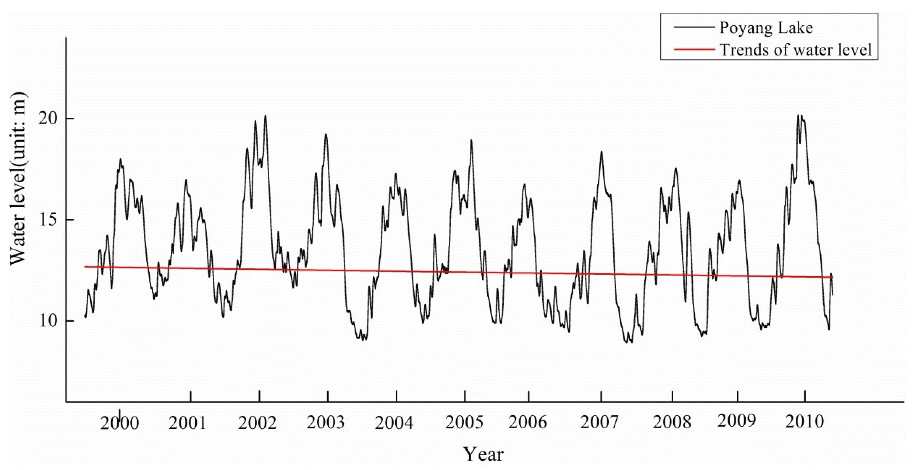
3.1. Characteristics of Water Regime in Poyang Lake
3.2. Classification Characteristics of the Spring Wetland Landscape in Poyang Lake
3.3. Distribution Characteristics of the Spring Vegetation in Poyang Lake
3.4. Dynamic Responses of the Spring Landscape to Water Regime
4. Conclusions
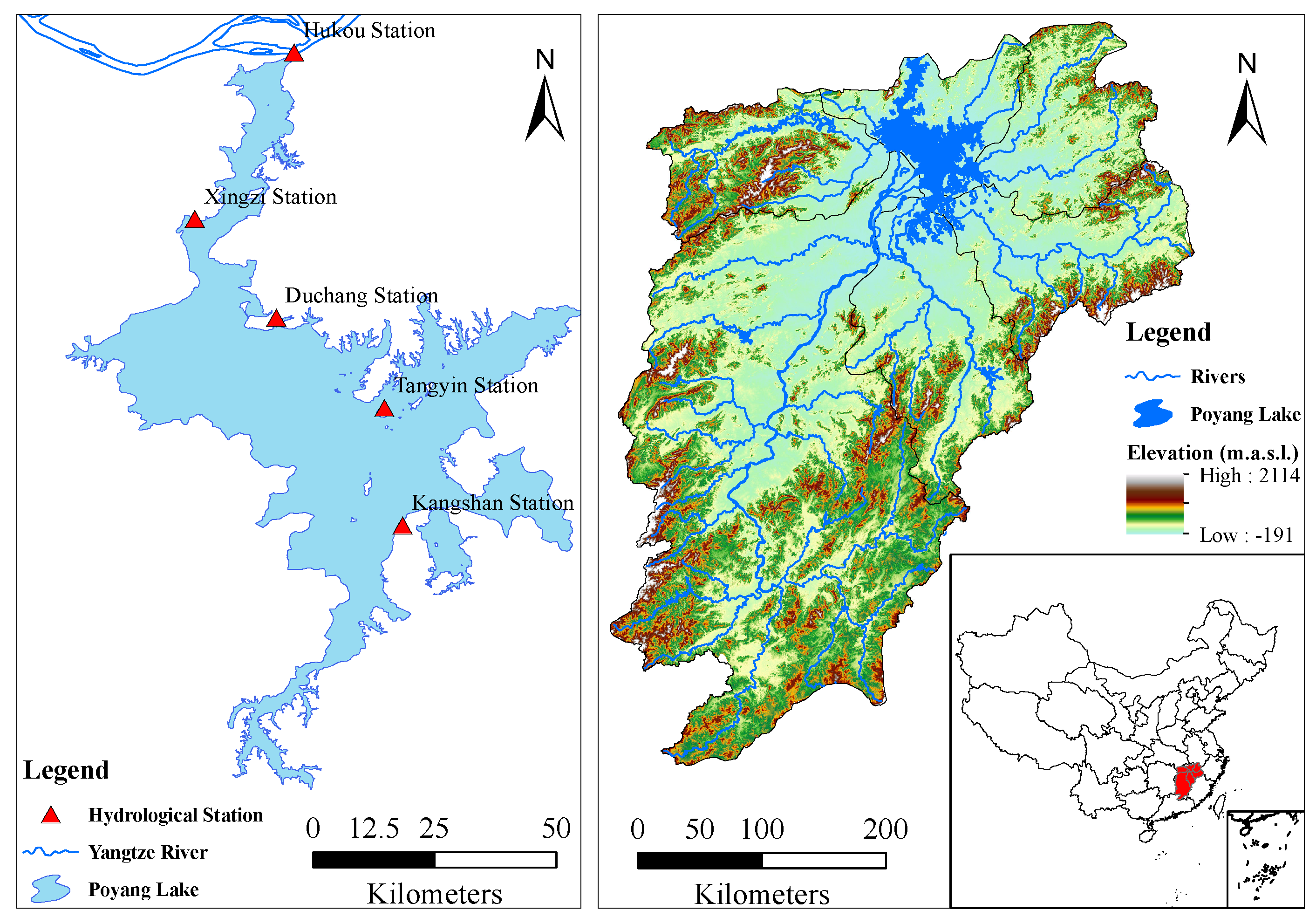
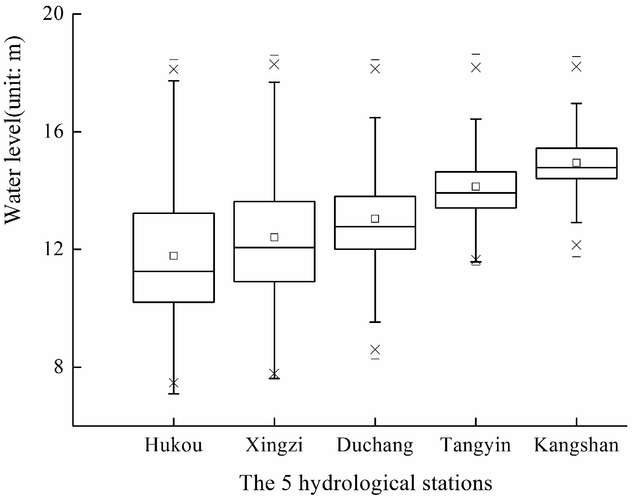
- The annual peak water levels of the five monitoring hydrological stations have no differences, but both the annual lowest and annual average water levels are significantly different in Poyang Lake. The annual lowest and annual average water level show the same sequence of Kangshan > Tangyin > Duchang > Xingzi > Hukou, which is just the same as the geographical location distribution of the five monitoring hydrological stations from south to north.
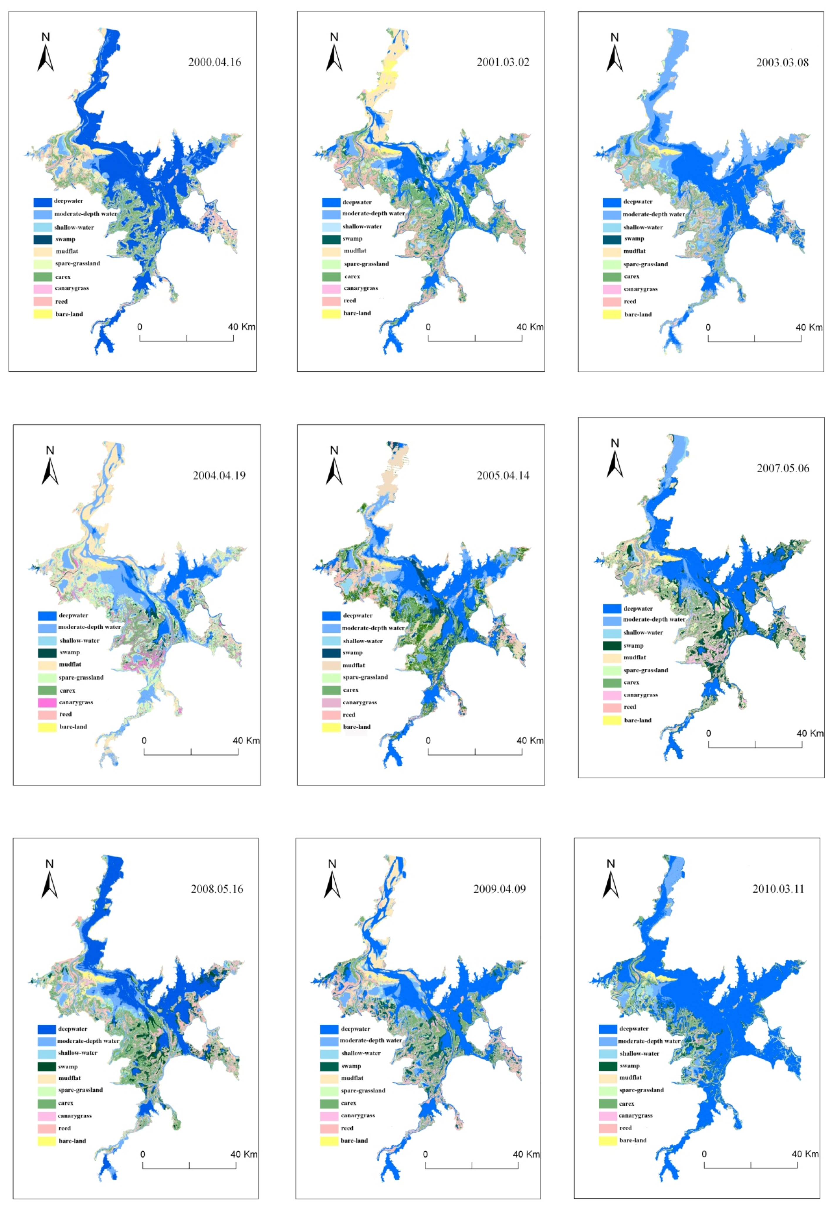
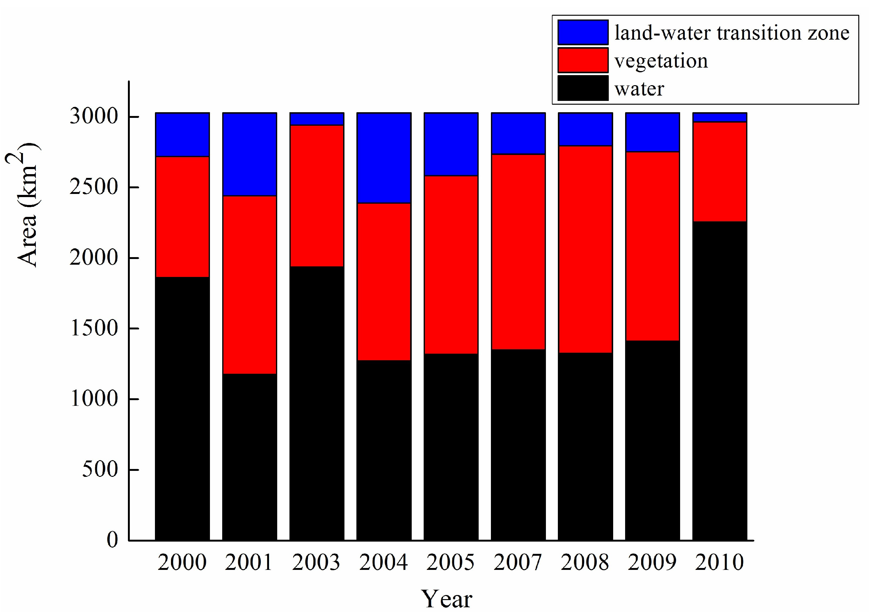
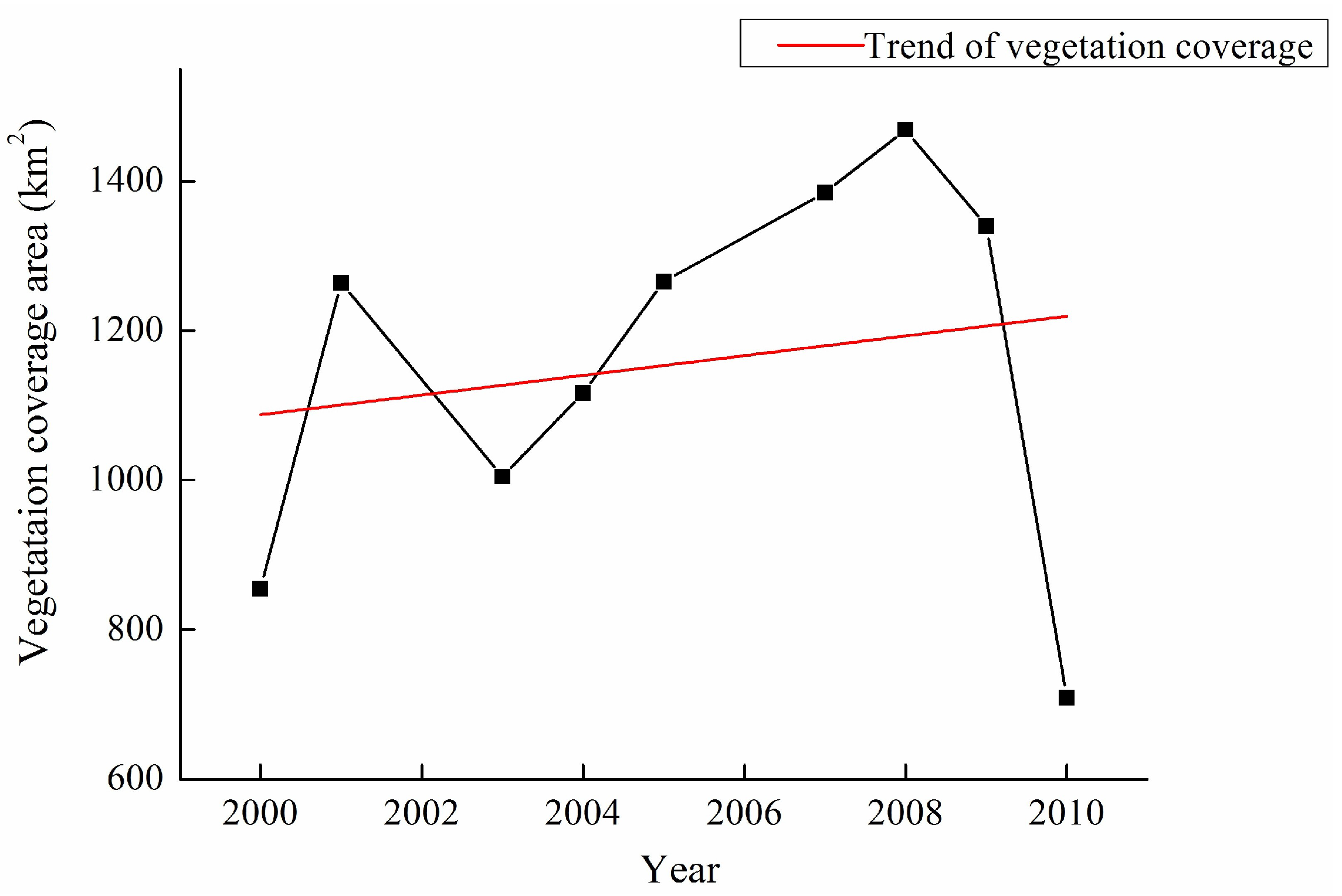
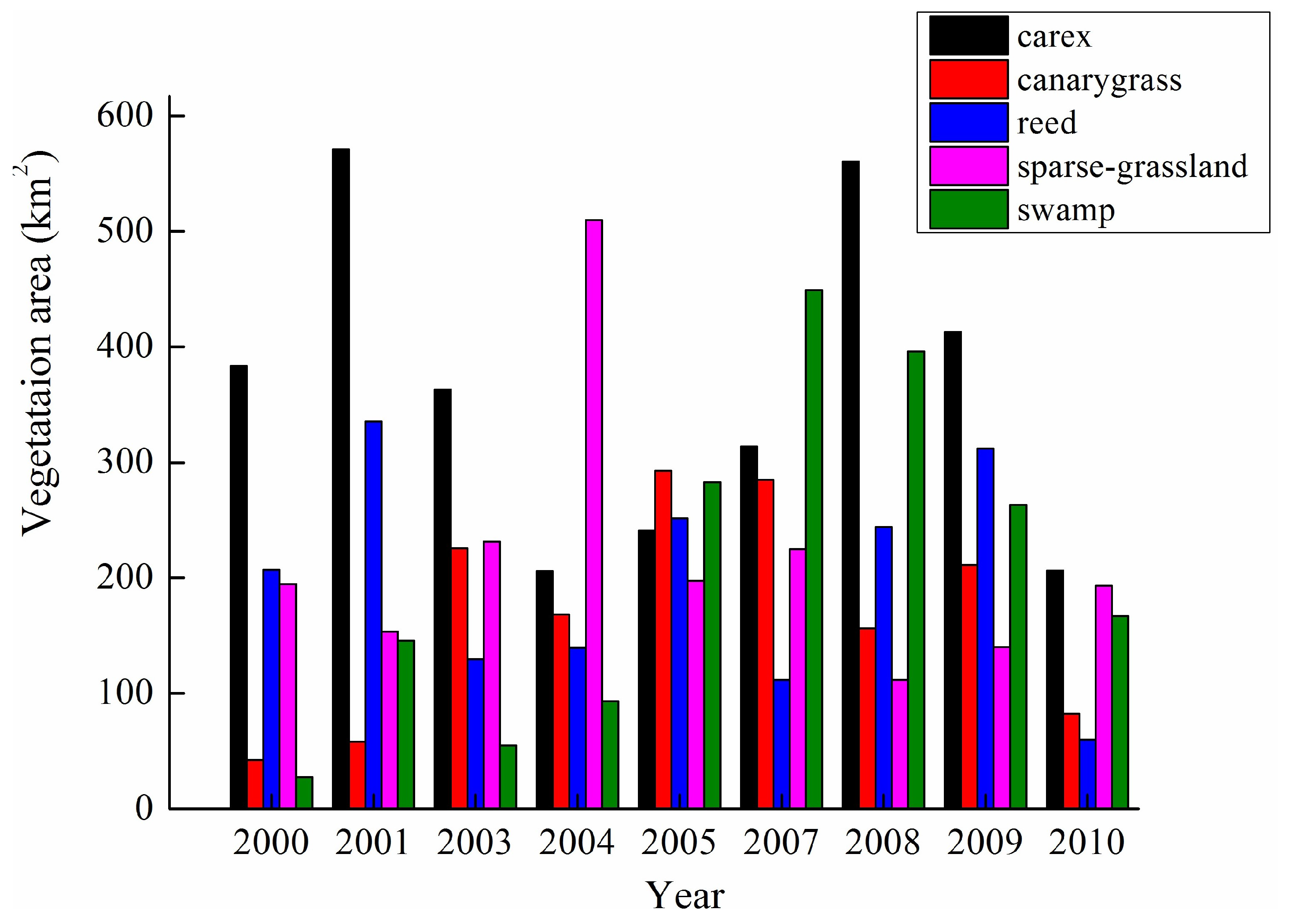
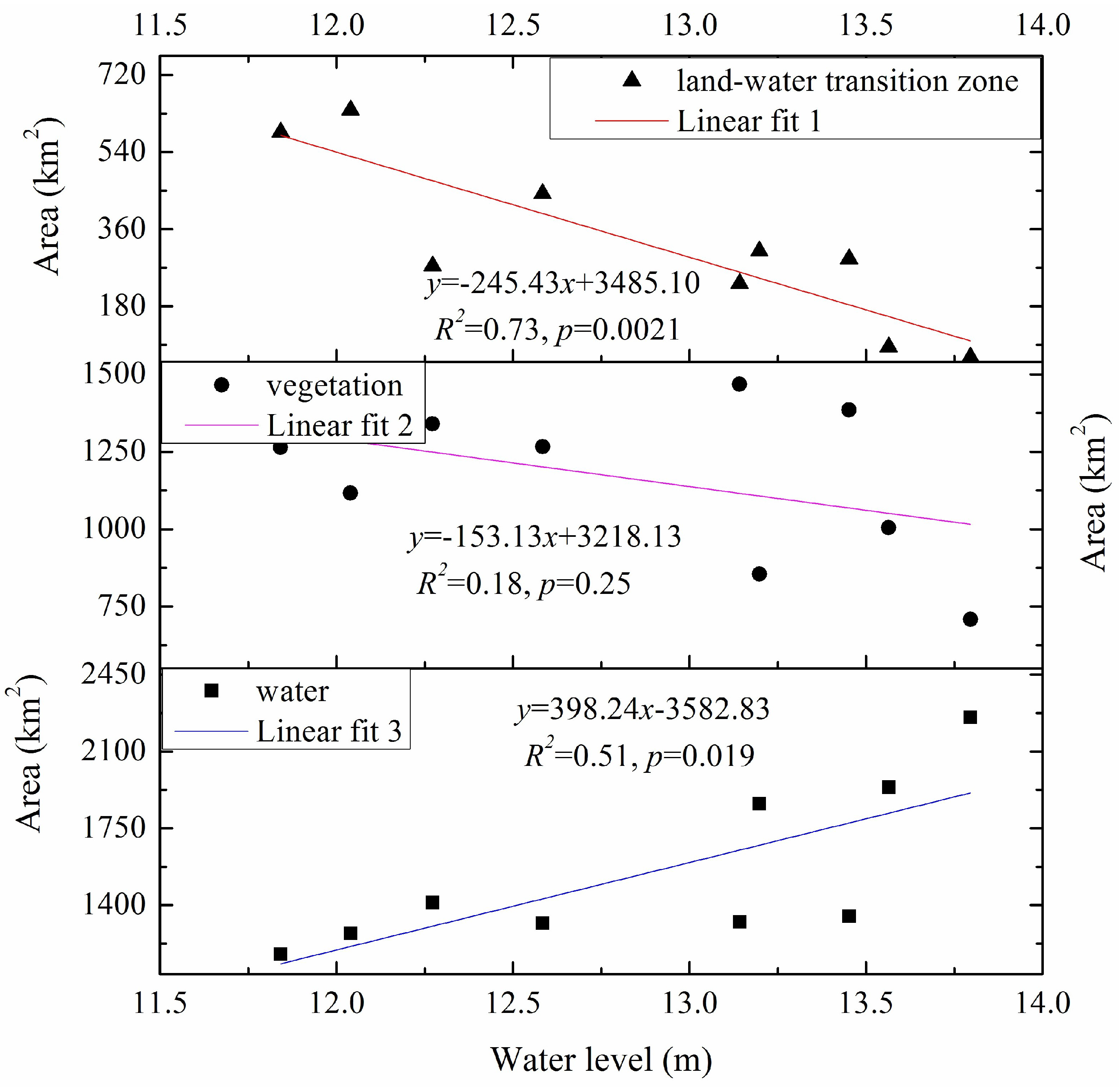
- The spring landscape extracted from the remote sensing images has two levels. The first level consists of water, vegetation, and land-water transition zone. On the basis of the first level, the second level includes ten types of wetland landscape, viz. deepwater, moderate-depth water, shallow-water, swamp, sparse-grassland, carex, canarygrass, reed, mudflat and bare-land. The area of each landscape is different every year, but the total area of the Poyang Lake wetland is almost same, which is always maintained at about 3026 km2 or so in springs during 2000–2010.
- The linear fitting degree of the landscape with the water level followed by the order of land-water transition zone > water> vegetation. The deepwater shows a significant positive correlation with the water level, and is negatively correlated with the shallow water. The mudflat is very significantly negatively correlated with the water level, and is significantly negatively correlated with the deepwater. The carex is significantly positively correlated with the reed and the bare-land.
Acknowledgments
Author Contributions
Conflicts of Interest
References
- Mitsch, W.J.; Gosselink, J.G. Wetlands; Wiley: Hoboken, NJ, USA, 2007. [Google Scholar]
- Van Der Valk, A.G. Water-level fluctuations in North American prairie wetlands. Hydrobiologia 2005, 539, 171–188. [Google Scholar] [CrossRef]
- Boon, P.; Schofield, N.; Brock, M.; Bunn, S. National Wetlands R&D Program: Scoping Review; Land and Water Resources Research and Development Corporation Occasional Paper 01/97 Canberra; Land and Water Resources Research and Development Corporation: Canberra, Australia, 1997.
- Steinman, A.D.; Ogdahl, M.E.; Weinert, M.; Uzarski, D.G. Influence of water-level fluctuation duration and magnitude on sediment-water nutrient exchange in coastal wetlands. Aquat. Ecol. 2014, 48, 143–159. [Google Scholar] [CrossRef]
- Chen, X.; Bao, S.; Li, H.; Wu, Z.; Fu, W.; Cai, X.; Zhao, H.; Liu, Y.; Peng, G. Modeling the Impacts of Land Use/cover Change on Sediment Load in Wetlands of the Poyang Lake Basin. In Proceedings of the International Conference on Hydrology and Management of Forested Wetlands, New Bern, NC, USA, 8–12 April 2006. [Google Scholar]
- Ramsar, C. The List of Wetlands of International Importance; RAMSAR Secretariat: Gland, Switzerland, 2004. [Google Scholar]
- Zhu, H.; Zhang, B. Poyang Lake; Press of University of Science and Technology of China: Hefei, China, 1997; pp. 146–233. [Google Scholar]
- Nõges, T.; Nõges, P. The effect of extreme water level decrease on hydrochemistry and phytoplankton in a shallow eutrophic lake. Hydrobiologia 1999, 408, 277–283. [Google Scholar] [CrossRef]
- Han, X.; Chen, X.; Feng, L. Four decades of winter wetland changes in Poyang Lake based on Landsat observations between 1973 and 2013. Remote Sens. Environ. 2015, 156, 426–437. [Google Scholar] [CrossRef]
- You, H.; Xu, L.; Liu, G.; Wang, X.; Wu, Y.; Jiang, J. Effects of inter-annual water level fluctuations on vegetation evolution in typical wetlands of Poyang Lake, China. Wetlands 2015, 35, 931–943. [Google Scholar] [CrossRef]
- Xie, D.M.; Zheng, P.; Deng, H.; Zhao, J.; Fan, Z.; Fang, Y. Landscape responses to changes in water levels at Poyang Lake wetlands. Shengtai Xuebao/Acta Ecol. Sin. 2011, 31, 1269–1276. (In Chinese) [Google Scholar]
- Dai, X.; Yang, G.S.; Wan, R.R.; Bing, L.I.; Wang, X.L. Ecosystem Health Assessment of Poyang Lake Wetland and the Associated Hydrological Conditions. Resour. Environ. Yangtze Basin 2016, 25, 1395–1402. [Google Scholar]
- Liu, M.X.; Xu, X.L.; Sun, A.Y.; Wang, K.L.; Liu, W.; Zhang, X.Y. Is southwestern China experiencing more frequent precipitation extremes? Environ. Res. Lett. 2014, 9, 064002. [Google Scholar] [CrossRef]
- Lu, J.; Finlayson, C.M.; Van der Valk, A.G. Ecological significance and classification of Chinese wetlands. Plant Ecol. 1995, 118, 49–56. [Google Scholar] [CrossRef]
- Deng, S.B. ENVI: Remote Sensing Image Processing Method; Science Press: Beijing, China, 2010. (In Chinese) [Google Scholar]
- Wu, L. The study on effects of Three Gorge Project to environment of Poyang Lake. J. Hydraul. Eng. 2007, S1, 586–591. (In Chinese) [Google Scholar]
- Bai, L. Characteristics of Water Level Variation and Its Influencing Factors in Poyang Lake. Ph.D. Thesis, Nanjing Institute of Geography and Limnology, Chinese Academy of Sciences, Nanjing, China, 2010. (In Chinese). [Google Scholar]
- Hu, Q.; Feng, S.; Guo, H.; Chen, G.; Jiang, T. Interactions of the Yangtze river flow and hydrologic processes of the Poyang Lake, China. J. Hydrol. 2007, 347, 90–100. [Google Scholar] [CrossRef]
- Li, Y.; Zhang, Q.; Li, X.; Yao, J. Hydrological Effects of Poyang Lake Catchment in Response to Climate Changes. Resour. Environ. Yangtze Basin 2013, 22, 1339–1347. [Google Scholar]
- Lai, X.; Shankman, D.; Huber, C.; Yesou, H.; Huang, Q.; Jiang, J. Sand mining and increasing Poyang Lake’s discharge ability: A reassessment of causes for lake decline in China. J. Hydrol. 2014, 519, 1698–1706. [Google Scholar] [CrossRef]
- Guo, H.; Hu, Q.; Zhang, Q.; Feng, S. Effects of the Three Gorges Dam on Yangtze River flow and river interaction with Poyang Lake, China: 2003–2008. J. Hydrol. 2012, 416–417, 19–27. [Google Scholar] [CrossRef]
- Zhang, L.L.; Yin, J.X.; Jiang, Y.Z.; Wang, H. Relationship between the hydrological conditions and the distribution of vegetation communities within the Poyang Lake National Nature Reserve, China. Ecol. Inform. 2012, 11, 65–75. [Google Scholar] [CrossRef]
- Feng, W.; Xu, L.; Wang, X.; Li, H.; Jiang, J. Response of Carex cinerascens populations to groundwater level gradients in the Poyang Lake wetland. Acta Ecol. Sin. 2016, 36, 5109–5115. (In Chinese) [Google Scholar]
- Yu, H.; Wu, Y.; Zhang, J.; Deng, B.; Zhu, Z.Y. Impact of extreme drought and the Three Gorges Dam on transport of particulate terrestrial organic carbon in the Changjiang (Yangtze) River. J. Geophys. Res. Earth Surf. 2011, 116. [Google Scholar] [CrossRef]
- Zhang, Y.; Xu, H.; Chen, H.; Wang, F.; Huai, H. Diversity of wetland plants used traditionally in China: A literature review. J. Ethnobiol. Ethnomed. 2014, 10, 72. [Google Scholar] [CrossRef] [PubMed]
- Naumburg, E.; Mata-Gonzalez, R.; Hunter, R.G.; Mclendon, T.; Martin, D.W. Phreatophytic Vegetation and Groundwater Fluctuations: A Review of Current Research and Application of Ecosystem Response Modeling with an Emphasis on Great Basin Vegetation. Environ. Manag. 2005, 35, 726–740. [Google Scholar] [CrossRef] [PubMed]
- Hu, Z.; Ge, G.; Liu, C.; Chen, F.; Li, S. Structure of Poyang Lake wetland plants ecosystem and influence of lake water level for the structure. Resour. Environ. Yangtze Basin 2010, 19, 597–605. (In Chinese) [Google Scholar]


| Sensor | Date | Cloud Coverage (%) |
|---|---|---|
| ETM+ | 16 April 2000 | Cloud Coverage < 15%, and meanwhile, it can be ensured that over the study area were all cloudless. |
| ETM+ | 2 March 2001 | |
| ETM+ | 8 March 2003 | |
| TM | 19 April 2004 | |
| TM | 14 April 2005 | |
| ETM+SLC-off | 6 May 2007 | |
| TM | 16 May 2008 | |
| ETM+SLC-off | 9 April 2009 | |
| ETM+SLC-off | 11 March 2010 |
| Wetland Type | Wetland Subtype | Description of Structural and Functional Characterization |
|---|---|---|
| Water | deepwater | The water depth is more than 50 cm. It is mainly distributed in the rivers, human-controlled lake areas and some parts of the large lakes in the north of Songmen Mountain in Poyang Lake. The flow velocity of the rivers is fast, making the river bed suffer from strong washing action, further resulting in the aquatic community being difficult to grow. The whole aquatic community is underdeveloped due to the insufficient conditions of light and oxygen. |
| moderate-depth water | The water depth was between 20 and 50 cm. It is mainly distributed in the middle of small seasonal lakes in delta wetland and the large lakes in the south of Songmen Mountain in Poyang Lake. The light and oxygen are relatively adequate in the area, being extremely rich in aquatic plants (mainly submerged plants), plankton, and benthos and fish resources. The regions are suitable habitats for large wading birds and swimming birds. | |
| shallow-water | The water depth was less than 20 cm, which is the transition zone for the moderate-depth water to the land. This region is gently inclined, with many types of floating-leaved macrophytes, where the aquatic community is similar to the moderate-depth water area. The foraging of the small wading birds and shore birds are often seen. | |
| Land-water transition zone | mudflat | The water level is further reduced due to natural evaporation and artificial discharging lake, and the lake bed is exposed. Abundant submerged plants and debris from filamentous algae are covering the land surface. The region is not a suitable habitat for water birds, but wild geese have a rest here once a while. |
| bare-land | The bare-land is formed by sediment deposition, basically with no vegetation coverage. It is mainly distributed in the northern lake area and the river nearby in the north of Songmen Mountain in Poyang Lake. The region always has fast flow velocity. It can often be seen covered with the thickness of 2–3 cm surface sediment in the dry season. The surface sediment is washed away by hydraulic action in the wet season. | |
| Vegetation (exposed meadow) | marsh | The marsh is close to the boundary between land and water with saturated soil, where it is mainly covered by the residual debris of aquatic plants. The soil layer consisted of incubation meadow soil, which generally alternated between wet and dry conditions more than three or four times during the year. The marsh is a good foraging site for many species of waterfowls. |
| canarygrass | The canarygrass is a perennial herb and is fond of damp environment . It is close to the mudflat, showing a zonal distribution. It has well-developed roots distributed in soil layers of 3–30 cm. It has strong resistance of drought and waterlogging, which can be used to keep soil and water better. The canarygrass grows best in tidal slag sandy soil with high organic matter content in the low-lying swamp meadows and flooded meadows. It is also suitable to grow in the fertile loam and clay. | |
| sparse-grassland | The soil layer consisted of meadow soil, and the soil was saturated. The marsh plants grew on sparse grassland, which was located at a low elevation. The germination time of the vegetation was short, and the vegetation grew sparsely. The fresh buds of the vegetation were eaten by waterfowl. | |
| carex (dense grassland) | The carex is the dominant species most widely distributed in the Poyang Lake wetland. It germinates and grows rapidly in the beach wetland with high elevation and long-term exposure. The carex has large coverage and good concealment, where feathers and resting marks of the waterfowls during the evening can be seen. | |
| reed | The reed is a representative of highland-emergent aquatic plants in the wet season, and withers in winter. The sub-lakes and rivers are separated from Poyang Lake, in the winter. At that time, the withered reed is distributed around the lakes, then forming a better concealment. |
| Variables | Water Level | Deep-Water | Moderate-Depth Water | Shallow-Water | Mudflat | Bare-Land | Marsh | Canary-Grass | Sparse-Grassland | Carex | Reed |
|---|---|---|---|---|---|---|---|---|---|---|---|
| water level | 1 | 0.667 * | −0.033 | −0.366 | −0.861 ** | −0.385 | 0.11 | 0.066 | −0.256 | −0.245 | −0.718 * |
| deepwater | 1 | −0.51 | −0.718 * | −0.708 * | −0.235 | −0.144 | −0.375 | −0.438 | −0.207 | −0.387 | |
| moderate-depth water | 1 | 0.561 | 0.116 | −0.126 | −0.478 | 0.212 | 0.597 | −0.185 | −0.257 | ||
| shallow-water | 1 | 0.39 | −0.086 | −0.022 | 0.116 | 0.562 | −0.004 | 0.05 | |||
| mudflat | 1 | 0.233 | −0.097 | −0.023 | 0.519 | −0.002 | 0.427 | ||||
| bare-land | 1 | 0.063 | −0.397 | −0.344 | 0.738 * | 0.505 | |||||
| marsh | 1 | 0.558 | −0.364 | 0.163 | 0.096 | ||||||
| canary-grass | 1 | 0.105 | −0.323 | −0.104 | |||||||
| sparse-grassland | 1 | −0.613 | −0.444 | ||||||||
| carex | 1 | 0.692 * | |||||||||
| reed | 1 |
© 2017 by the authors. Licensee MDPI, Basel, Switzerland. This article is an open access article distributed under the terms and conditions of the Creative Commons Attribution (CC BY) license (http://creativecommons.org/licenses/by/4.0/).
Share and Cite
You, H.; Fan, H.; Xu, L.; Wu, Y.; Wang, X.; Liu, L.; Yao, Z.; Yan, B. Effects of Water Regime on Spring Wetland Landscape Evolution in Poyang Lake between 2000 and 2010. Water 2017, 9, 467. https://doi.org/10.3390/w9070467
You H, Fan H, Xu L, Wu Y, Wang X, Liu L, Yao Z, Yan B. Effects of Water Regime on Spring Wetland Landscape Evolution in Poyang Lake between 2000 and 2010. Water. 2017; 9(7):467. https://doi.org/10.3390/w9070467
Chicago/Turabian StyleYou, Hailin, Hongxiang Fan, Ligang Xu, Yongming Wu, Xiaolong Wang, Lizhen Liu, Zhong Yao, and Bangyou Yan. 2017. "Effects of Water Regime on Spring Wetland Landscape Evolution in Poyang Lake between 2000 and 2010" Water 9, no. 7: 467. https://doi.org/10.3390/w9070467