Is There Urban Landscape in Metropolitan Areas? An Unobvious Answer Based on Corine Land Cover Analyses
Abstract
:1. Introduction
2. Materials and Methods
2.1. Study Area
2.2. Materials
- Artificial surfaces—built-up areas, including residential areas, commercial and industrial areas, mines, and green urban spaces.
- Agricultural areas—arable land, permanent crops, meadows, pastures, and land principally occupied by agriculture with significant areas of natural vegetation.
- Forests and semi-natural areas—forests, shrubs and open areas with little or no vegetation.
- Wetlands—inland marshes, peatbogs, salt marshes, salines, and intertidal flats.
- Water bodies—inland waters and marine waters.
2.3. Methods
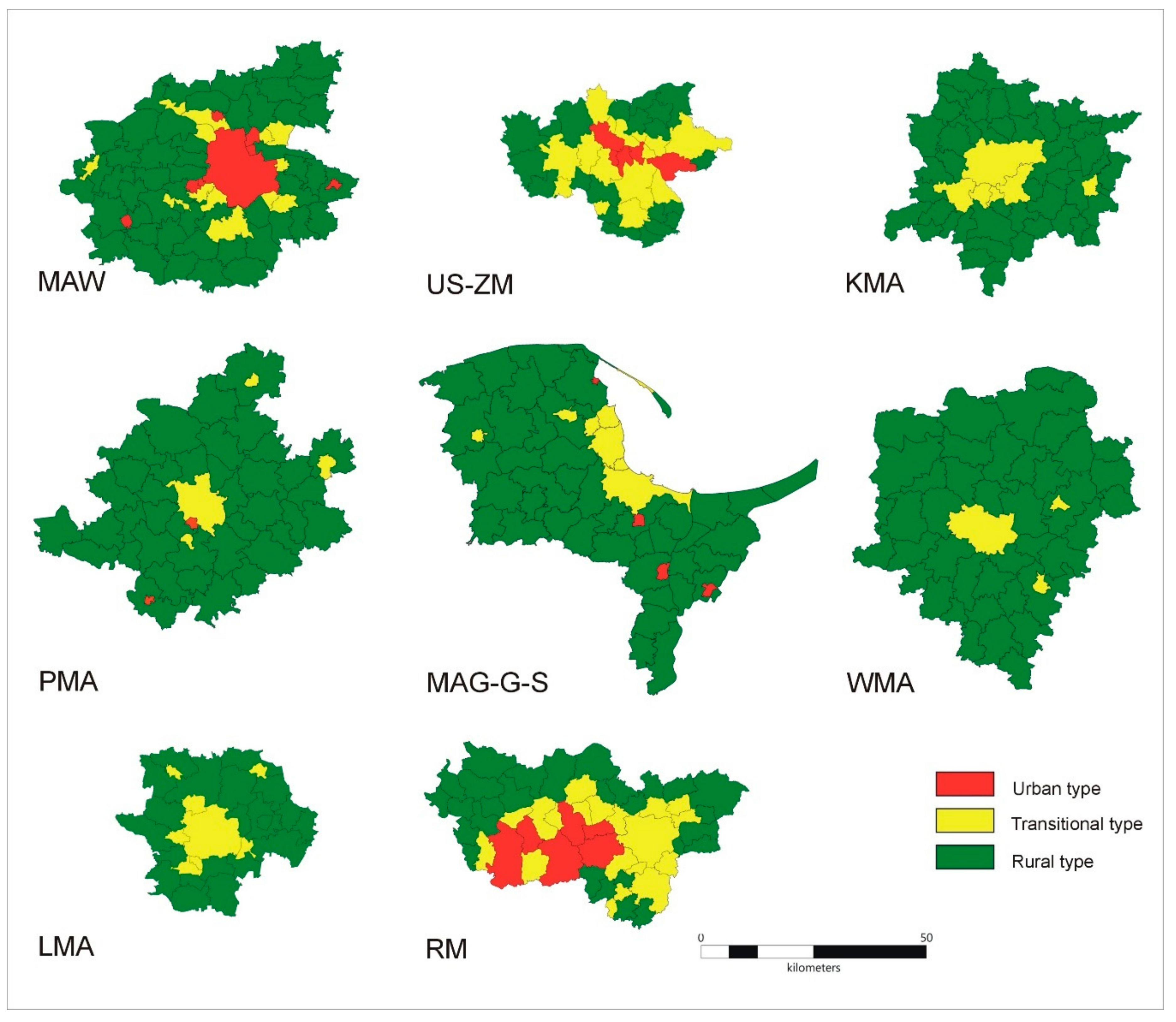
- The urban type of landscape includes units where 0.5 < ULII ≤ 1.0;
- The transitional type of landscape includes unit types where 0.3 ≤ ULII ≤ 0.5;
- The rural type of landscape includes units where 0 ≤ ULII < 0.3.
3. Results
3.1. Metropolitan Areas Level
3.2. Municipalities Level
3.3. Hexagon Level
4. Discussion
5. Conclusions
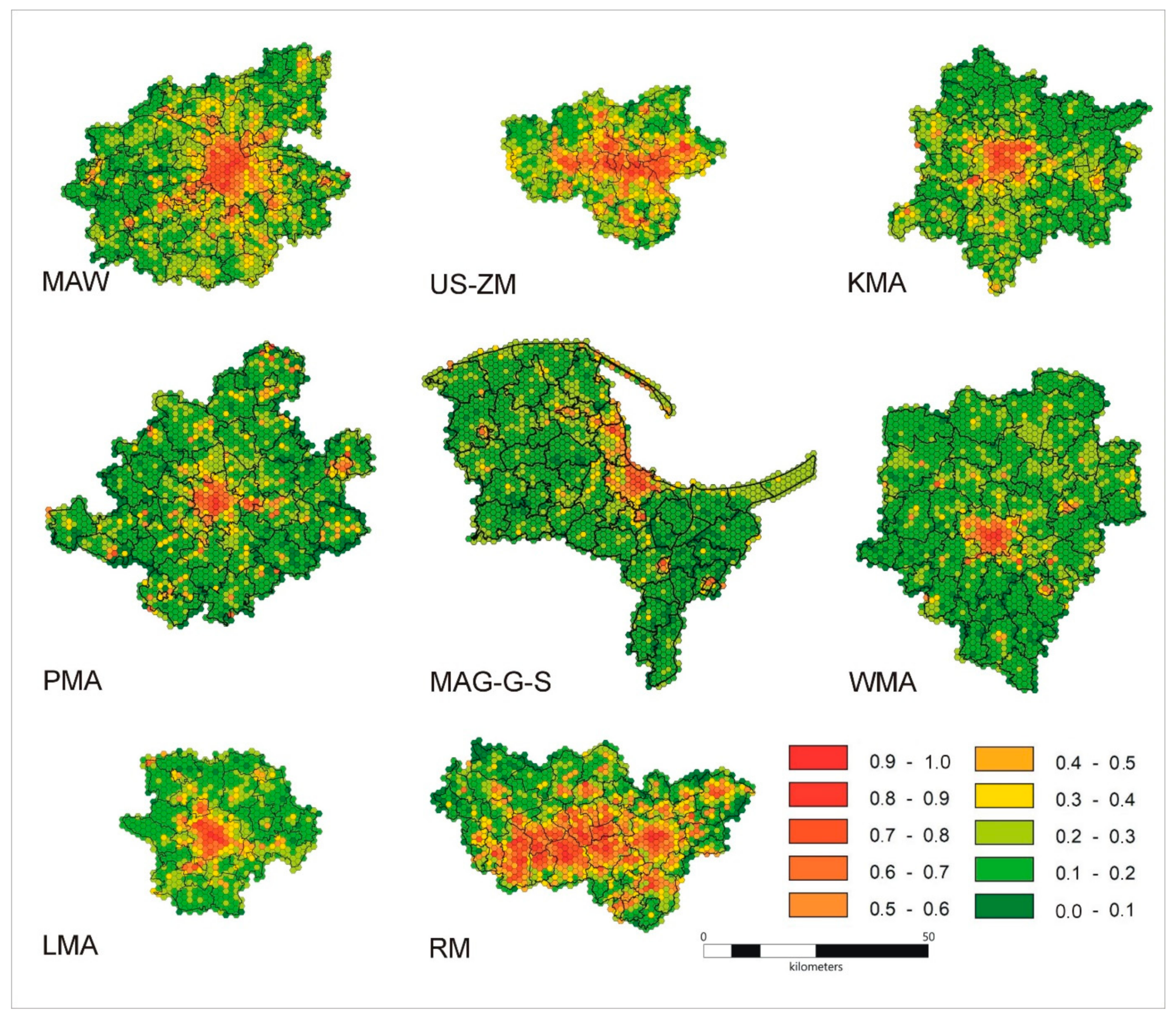
- The landscape of the US-ZM differs from the landscape of other metropolitan areas in Poland and shows some similarities to the RM landscape. These areas are polycentric agglomerations. Nevertheless, the landscape of MAW shows some similarities to the US-ZM one despite the fact that this area is a monocentric agglomeration. This may be connected with the capital function of Warszawa that has an influence on the urbanization level.
- Rural and transitional landscapes predominate within the metropolitan areas delineated according to official documents and administrative affiliation, while the typical urban landscape is characteristic only of the central zones of metropolitan areas. This conclusion may be considered controversial because it proves that in determining the features of a metropolitan area the landscape approach differs from the formal and legal approaches and also based on area and demographic criteria.
- Basic landscape analysis on an administrative level gives a distorted spatial picture. Therefore, the use of basic units (in this case, hexagons) for the assessment of metropolitan landscape diversity is recommended. Only by using this analysis can all the complexity and diversity of the internal structure of the metropolitan areas landscape be shown.
Supplementary Materials
Author Contributions
Funding
Institutional Review Board Statement
Informed Consent Statement
Data Availability Statement
Acknowledgments
Conflicts of Interest
References
- Antrop, M. Background concepts for integrated landscape analysis. Agric. Ecosyst. Environ. 2000, 77, 17–28. [Google Scholar] [CrossRef]
- Pacione, M. Urban Geography: A Global Perspective; Routledge: London, UK, 2001. [Google Scholar]
- Antrop, M. Landscape change and the urbanization process in Europe. Landsc. Urban Plan. 2004, 67, 9–26. [Google Scholar] [CrossRef]
- Seto, K.C.; Güneralp, B.; Hutyra, L.R. Global forecasts of urban expansion to 2030 and direct impacts on biodiversity and carbon pools. Proc. Natl. Acad. Sci. USA 2012, 109, 16083–16088. [Google Scholar] [CrossRef] [PubMed] [Green Version]
- Champion, T. Urbanization, suburbanisation, counterurbanisation and reurbanisation. In Handbook of Urban Studies; Paddison, R., Ed.; Sage: London, UK, 2001; pp. 143–161. [Google Scholar]
- Hennig, E.I.; Schwick, C.; Soukup, T.; Orlitová, E.; Kienast, F.; Jaeger, J.A. Multi-scale analysis of urban sprawl in Europe: Towards a European de-sprawling strategy. Land Use Policy 2015, 49, 483–498. [Google Scholar] [CrossRef] [Green Version]
- Chmielewski, T.J. Systemy Krajobrazowe. Struktura, Funkcjonowanie, Planowanie; PWN: Warszawa, Poland, 2012; pp. 1–408. [Google Scholar]
- Breuste, J.H. Decision making, planning and design for the conservation of indigenous vegetation within urban development. Landsc. Urban Plan. 2004, 68, 439–452. [Google Scholar] [CrossRef]
- Enache, C.; Popa, A. Decoding the Urban Landscape. Postmodern Openings 2019, 10, 272–279. [Google Scholar] [CrossRef]
- Zuzańska-Żyśko, E. Procesy Metropolizacji. Teoria i Praktyka; PWN: Warszawa, Poland, 2016; pp. 1–432. [Google Scholar]
- Wheeler, S. The Evolution of Built Landscapes in Metropolitan Regions. J. Plan. Educ. Res. 2008, 27, 400–416. [Google Scholar] [CrossRef]
- Bosselmann, P.; Ruggeri, D. The Future Metropolitan Landscape; Pratt Institute University of California, Berkeley College of Environmental Design: Berkeley, CA, USA, 2019. [Google Scholar]
- MacKenzie, A. Understanding Metropolitan Landscapes; Routledge: London, UK, 2020. [Google Scholar]
- Beunen, R.; Van Ark, R.; Van der Valk, A.; Jaarsma, R. Planning nature conservation in Dutch metropolitan landscapes. In Planning Metropolitan Landscapes—Concepts, Demands, Approaches; Tress, G., Tress, B., Harms, B., Smeets, P., Van der Valk, A., Eds.; DELTA Series 4; DELTA: Wageningen, The Netherlands, 2004; pp. 166–177. [Google Scholar]
- Kijowska, J.; Kijowski, A.; Rączkowski, W. Politics and landscape change in Poland 1940–2000. In Landscape Through the Lens Aerial Photographs and Historic Environment; Cowley, D.C., Standring, R.A., Abicht, M.J., Eds.; Oxbow Books: Oxford/Oakville, UK, 2010; pp. 155–166. [Google Scholar]
- Qureshi, S.; Hamstead, Z.; Spyra, M.; Qureshi, S. Beyond urban–rural dichotomies: Measuring urbanisation degrees in central European landscapes using the technomass as an explicit indicator. Ecol. Indic. 2019, 96, 466–476. [Google Scholar] [CrossRef]
- Dadashpoor, H.; Azizi, P.; Moghadasi, M. Land use change, urbanization, and change in landscape pattern in a metropolitan area. Sci. Total Environ. 2019, 655, 707–719. [Google Scholar] [CrossRef]
- Aguilera, F.; Valenzuela, L.M.; Botequilha-Leitão, A. Landscape metrics in the analysis of urban land use patterns: A case study in a Spanish metropolitan area. Landsc. Urban Plan. 2011, 99, 226–238. [Google Scholar] [CrossRef]
- Reis, J.P.; Silva, E.A.; Pinho, P. Spatial metrics to study urban patterns in growing and shrinking cities. Urban Geogr. 2015, 37, 246–271. [Google Scholar] [CrossRef]
- Tate, C.; Cuffney, T.F.; McMahon, G.; Giddings, E.M.P. Use of an Urban Intensity Index to Assess Urban Effects on Streams in Three Contrasting Environmental Settings; American Fisheries Society Symposium: Bethesda, MD, USA, 2005; Volume 47, pp. 291–315. [Google Scholar]
- McMahon, G.; Cuffney, T.F. Quantifying urban intensity in drainage basins for assessing stream ecological conditions. JAWRA J. Am. Water Resour. Assoc. 2000, 36, 1247–1261. [Google Scholar] [CrossRef]
- Li, G.; Sun, S.; Fang, C. The varying driving forces of urban expansion in China: Insights from a spatial-temporal analysis. Landsc. Urban Plan. 2018, 174, 63–77. [Google Scholar] [CrossRef]
- Weng, Y.-C. Spatiotemporal changes of landscape pattern in response to urbanization. Landsc. Urban Plan. 2007, 81, 341–353. [Google Scholar] [CrossRef]
- Huang, B.; Zhang, L.; Wu, B. Spatiotemporal analysis of rural–urban land conversion. Int. J. Geogr. Inf. Sci. 2009, 23, 379–398. [Google Scholar] [CrossRef]
- Biłozor, A.; Czyża, S.; Bajerowski, T. Identification and Location of a Transitional Zone between an Urban and a Rural Area Using Fuzzy Set Theory, CLC, and HRL Data. Sustainability 2019, 11, 7014. [Google Scholar] [CrossRef] [Green Version]
- Matuszewska, M.; Będkowski, K.M. Analysis of the development of the city Sieradz based on the interpretation of aerial imagery and valorisation of the space using elements of fuzzy sets theory. Acta Scientiarum Polonorum Administratio Locorum 2019, 18, 381–395. [Google Scholar] [CrossRef]
- Taubenböck, H.; Gerten, C.; Rusche, K.; Siedentop, S.; Wurm, M. Patterns of Eastern European urbanisation in the mirror of Western trends—Convergent, unique or hybrid? Environ. Plan. B Urban Anal. City Sci. 2019, 46, 1206–1225. [Google Scholar] [CrossRef] [Green Version]
- Marciniak, M. Wybrane aspekty oceny krajobrazu obszarów metropolitalnych. Biul. Pol. Akad. Nauk. Kom. Przestrz. Zagospod. Kraju 2015, 259, 159–174. [Google Scholar]
- Kamiński, J.; Podgórska, A. Krajobraz w poznańskim obszarze metropolitalnym–delimitacja, typologia i zasady ochrony. Metropolitan. Przegląd Nauk. 2016, 2, 46–63. [Google Scholar]
- Gómez, J.M.N.; Lousada, S.; Velarde, J.G.G.; Castanho, R.A.; Loures, L. Land-Use Changes in the Canary Archipelago Using the CORINE Data: A Retrospective Analysis. Land 2020, 9, 232. [Google Scholar] [CrossRef]
- Cieślak, I.; Biłozor, A.; Szuniewicz, K. The Use of the CORINE Land Cover (CLC) Database for Analyzing Urban Sprawl. Remote. Sens. 2020, 12, 282. [Google Scholar] [CrossRef] [Green Version]
- Solecka, I.; Sylla, M.; Świąder, M. Urban Sprawl Impact on Farmland Conversion in Suburban Area of Wroclaw, Poland. IOP Conf. Ser. Mater. Sci. Eng. 2017, 245, 072002. [Google Scholar] [CrossRef]
- Benito, P.R.; Cuevas, J.A.; Bravo de la Parra, R.; Prieto, F.; Garcia del Barrio, J.M.; Zavala, M.A. Land use change in a Mediterranean metropolitan region and its periphery: Assessment of conservation policies through CLC and Markov model. For. Syst. 2010, 19, 315–328. [Google Scholar]
- Conway, T.M.; Hackworth, J. Urban pattern and land cover variation in the greater Toronto area. Can. Geogr./Le Géographe Can. 2007, 51, 43–57. [Google Scholar] [CrossRef] [Green Version]
- Biłozor, A. Application of Fuzzy Logic to the Identification and Localization of the Fringe Areas of the Cityand the Village. Acta Sci. Pol. –Adm. Locorum 2005, 4, 37–51. (In Polish) [Google Scholar]
- Sroka, W.; Mikolajczyk, J.; Wojewodzic, T.; Kwoczynska, B. Agricultural Land vs. Urbanisation in Chosen Polish Metropolitan Areas: A Spatial Analysis Based on Regression Trees. Sustainability 2018, 10, 837. [Google Scholar] [CrossRef] [Green Version]
- Smętkowski, M.; Jałowiecki, B.; Gorzelak, G. Obszary Metropolitalne w Polsce: Problemy Rozwojowe i Delimitacja; Uniwersytet Warszawski: Warszawa, Poland, 2018; pp. 1–98. [Google Scholar]
- Sroka, W.; Pölling, B. The Potential and Significance of Urban Agriculture on the Basis of the Ruhr Metropolis and the Upper Silesian Metropolis. Probl. World Agric. 2015, 15, 180–193. [Google Scholar]
- ISAP. The Council of Ministers Regulation of 26 June 2017 on the Establishment of the Following in Silesian Voivodship of the Metropolitan Association Called upper Silesia-Zagłębie Metropolis (Journal of Laws of 2017, Item 1290). Available online: http://isap.sejm.gov.pl/isap.nsf/DocDetails.xsp?id=WDU20170001290 (accessed on 19 November 2020).
- Strategy of Development of the Metropolitan Area of Warsaw until 2030, Strategia Rozwoju Obszaru Metropolitalnego Warszawy do Roku 2030. Available online: http://omw.um.warszawa.pl/wp-content/uploads/2015/09/Strategia-Rozwoju-Obszaru-Metropolitalnego.pdf (accessed on 19 November 2020).
- Resolution, No. XV/174/03 of 22 December 2003 on the Adoption of the Spatial Development Plan for the Małopolska Voivodship. Available online: https://bip.malopolska.pl/umwm,a,748635,uchwala-nr-xv17403-sejmiku-wojewodztwa-malopolskiego-z-dnia-22-grudnia-2003-r-w-sprawie-uchwalenia-p.html (accessed on 19 November 2020).
- Spatial Development Plan for the Poznań Metropolitan Area, Attachment No 2.0 to Resolution No. V/70/19 of the Sejmik of the Wielkopolska Region of 25 March 2019. Available online: https://bip.umww.pl/artykuly/2824952/pliki/20190328121632_70.pdf (accessed on 19 November 2020).
- Draft Metropolitan act of Metropolitan Association for Pomerania Voivodship. Available online: https://www.metropoliagdansk.pl/upload/files/66uch.pdf (accessed on 19 November 2020).
- Spatial Development Plan of Lower Silesian Voivodship. Available online: https://www.irt.wroc.pl/strona-128-plan_zagospodarowania_przestrzennego.html (accessed on 19 November 2020).
- Strategy of Development of Łódź Metropolitan Area 2020+. Annex to Resolution No 2/2016 of the Association Council of the Łódź Metropolitan Area of 24 March 2016. Available online: http://lom.lodz.pl/wp-content/uploads/Strategia-Rozwoju-%C5%81OM-2020-_-24.03.20161.pdf (accessed on 19 November 2020).
- Gesetz zur Stärkung der Regionalen und Interkommunalen Zusammenarbeit der Städte, Gemeinden und Kreise in Nordrhein-Westfalen Normstruktur. Available online: https://recht.nrw.de/lmi/owa/br_vbl_detail_text?anw_nr=6&vd_id=3669&vd_back=N96&sg=0&menu=1 (accessed on 19 November 2020).
- Jucha, W.; Kroczak, R. Comparison of land use data from the CORINE Land Cover program with data obtained from orthophotomaps. In Socio-Economic and Spatial Transformation of Regional Structures; Kaczmarska, E., Raźniak, P., Eds.; Oficyna Wydawnicza AFM: Kraków, Poland, 2014; pp. 123–136. (In Polish) [Google Scholar]
- Zwick, R.; Zimmermann, H.-J. Fuzzy Set Theory and Its Applications. Am. J. Psychol. 1993, 106, 304. [Google Scholar] [CrossRef]
- Pierenkemper, T. Entrepreneurs in Heavy Industry: Upper Silesia and the Westphalian Ruhr Region, 1852 to 1913. Bus. Hist. Rev. 1979, 53, 65–78. [Google Scholar] [CrossRef]
- Lan, F.; Da, H.; Wen, H.; Wang, Y. Spatial Structure Evolution of Urban Agglomerations and Its Driving Factors in Mainland China: From the Monocentric to the Polycentric Dimension. Sustainability 2019, 11, 610. [Google Scholar] [CrossRef] [Green Version]
- Clark, W.A.V. Monocentric to polycentric: New urban forms and old paradigms. In A Companion to the City; Bridge, G., Watson, S., Eds.; Blackwell: Oxford, UK, 2000; pp. 141–154. [Google Scholar]
- Gollin, D.; Jedwab, R.; Vollrath, D. Urbanization with and without industrialization. J. Econ. Growth 2016, 21, 35–70. [Google Scholar] [CrossRef]
- Scott, A.J. Resurgent Metropolis: Economy, Society and Urbanization in an Interconnected World. Int. J. Urban Reg. Res. 2008, 32, 548–564. [Google Scholar] [CrossRef]
- Pukowiec-Kurda, K.; Myga-Piątek, U.; Rahmonov, O. The landscape profile method as a new tool for sustainable urban planning. J. Environ. Plan. Manag. 2019, 62, 2548–2566. [Google Scholar] [CrossRef]
- Ebeke, C.H.; Etoundi, S.M.N. The Effects of Natural Resources on Urbanization, Concentration, and Living Standards in Africa. World Dev. 2017, 96, 408–417. [Google Scholar] [CrossRef]
- Miller, R.B.; Small, C. Cities from space: Potential applications of remote sensing in urban environmental research and policy. Environ. Sci. Policy 2003, 6, 129–137. [Google Scholar] [CrossRef]
- Maciukenaite, J.; Povilaitienė, I. The Role of the River in the City Centre and its Identity. J. Sustain. Arch. Civ. Eng. 2013, 4, 33–41. [Google Scholar] [CrossRef] [Green Version]
- Kline, J.D.; Moses, A.; Alig, R.J. Integrating Urbanization into Landscape-level Ecological Assessments. Ecosystems 2001, 4, 3–18. [Google Scholar] [CrossRef]
- Piao, Y.; Ma, K.M. Economic driving force of urban built-up area expansion in Beijing. Nat. Res. Econ. China 2006, 7, 34–37. (In Chinese) [Google Scholar]
- Wu, Y.; Zhang, X.; Skitmore, M.; Song, Y.; Hui, E.C. Industrial land price and its impact on urban growth: A Chinese case study. Land Use Policy 2014, 36, 199–209. [Google Scholar] [CrossRef] [Green Version]
- Ayazli, I.E. An Empirical Study Investigating the Relationship between Land Prices and Urban Geometry. ISPRS Int. J. Geo-Information 2019, 8, 457. [Google Scholar] [CrossRef] [Green Version]
- Burian, J.; Macků, K.; Zimmermannová, J.; Kočvarová, B. Spatio-Temporal Changes and Dependencies of Land Prices: A Case Study of the City of Olomouc. Sustainability 2018, 10, 4831. [Google Scholar] [CrossRef] [Green Version]
- Wei, Y.D.; Ye, X. Urbanization, urban land expansion and environmental change in China. Stoch. Environ. Res. Risk Assess. 2014, 28, 757–765. [Google Scholar] [CrossRef]
- García-Palomares, J.C. Urban sprawl and travel to work: The case of the metropolitan area of Madrid. J. Transp. Geogr. 2010, 18, 197–213. [Google Scholar] [CrossRef]
- Duranton, G.; Turner, M.A. The Fundamental Law of Road Congestion: Evidence from US Cities. Am. Econ. Rev. 2011, 101, 2616–2652. [Google Scholar] [CrossRef] [Green Version]
- Li, C.; Gao, X.; He, B.-J.; Wu, J.; Wu, K. Coupling Coordination Relationships between Urban-industrial Land Use Efficiency and Accessibility of Highway Networks: Evidence from Beijing-Tianjin-Hebei Urban Agglomeration, China. Sustainability 2019, 11, 1446. [Google Scholar] [CrossRef] [Green Version]
- Garcia-López, M.-A. Urban spatial structure, suburbanization and transportation in Barcelona. J. Urban Econ. 2012, 72, 176–190. [Google Scholar] [CrossRef] [Green Version]
- Baum-Snow, N. Did Highways Cause Suburbanization? Q. J. Econ. 2007, 122, 775–805. [Google Scholar] [CrossRef] [Green Version]
- Śleszyński, P.; Gibas, P.; Sudra, P. The Problem of Mismatch between the CORINE Land Cover Data Classification and the Development of Settlement in Poland. Remote Sens. 2020, 12, 2253. [Google Scholar] [CrossRef]


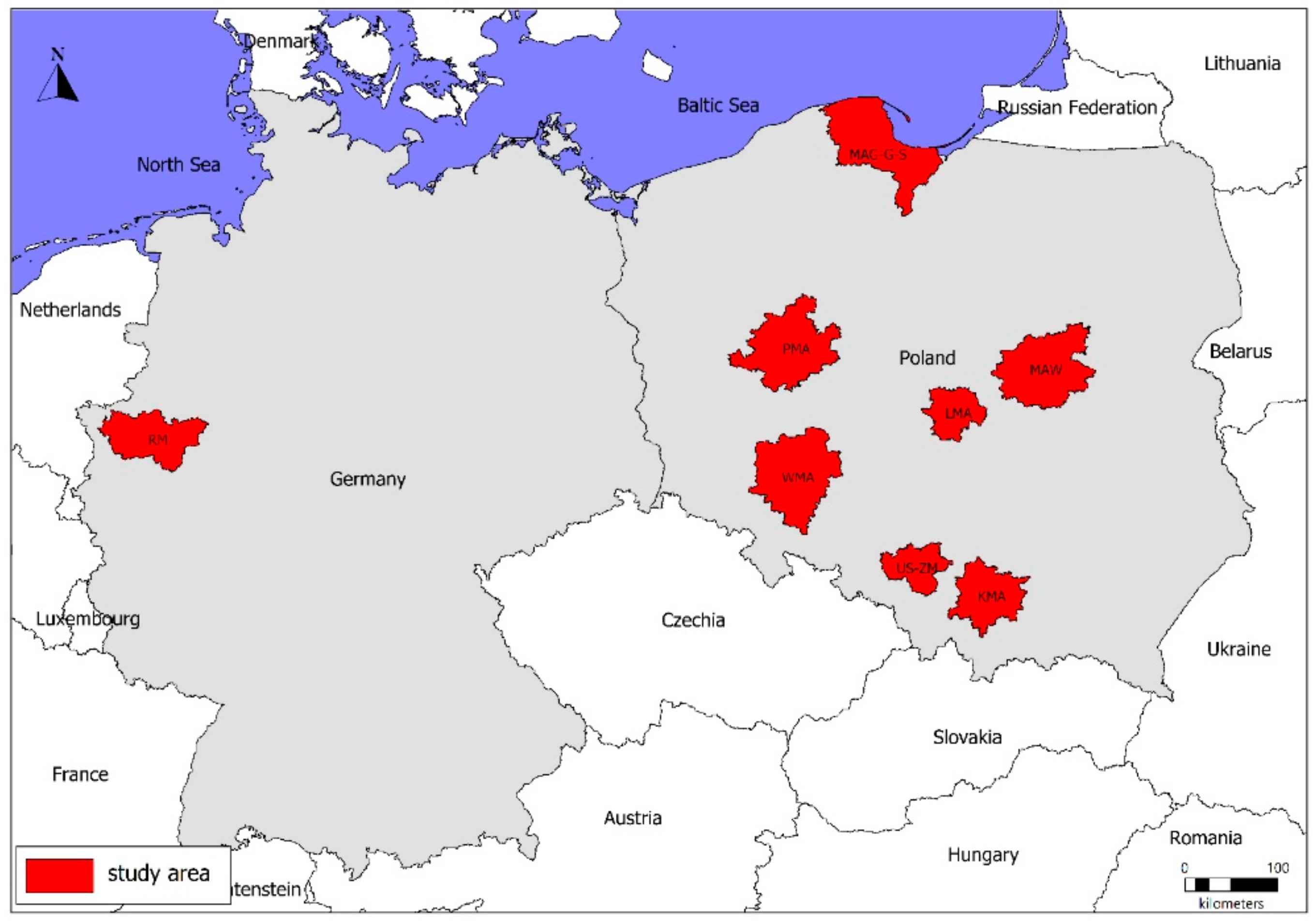
| Symbol | Name | Legal Act/Document | Population [mln] | Number of Municipalities | Area [km2] |
|---|---|---|---|---|---|
| MAW | Metropolitan Area of Warsaw | development strategy | 3.08 1 | 72 | 6206 |
| US-ZM | Upper Silesia-Zagłębie Metropolis | legally established metropolitan association | 2.30 2 | 41 | 2545 |
| KMA | Kraków Metropolitan Area | spatial development plan | 1.51 3 | 51 | 4060 |
| PMA | Poznań Metropolitan Area | spatial development plan | 1.33 4 | 45 | 6198 |
| MAG-G-S | Metropolitan Area Gdańsk-Gdynia-Sopot | Municipalities association, draft act | 1.50 5 | 56 | 6667 |
| WMA | Wrocław Metropolitan Association | spatial development plan/municipalities association | 1.20 6 | 44 | 6719 |
| LMA | Łódź Metropolitan Area | development strategy/spatial development plan | 1.10 7 | 28 | 2496 |
| RM | Ruhr Metropolis | Municipalities association | 5.10 8 | 33 | 4385 |
| Land Cover according to CLC—Level 3 | Degree of Belonging of Land Cover to the Urban Landscape (M) |
|---|---|
| 111 Continuous urban fabric | 1.00 |
| 112 Discontinuous urban fabric | 0.69 |
| 121 Industrial or commercial units | 0.97 |
| 122 Road and rail networks and associated land | 0.82 |
| 123 Port areas | 0.82 |
| 124 Airports | 0.82 |
| 131 Mineral extraction sites | 0.64 |
| 132 Dump sites | 0.64 |
| 133 Construction sites | 0.64 |
| 141 Green urban areas | 0.68 |
| 142 Sport and leisure facilities | 0.66 |
| 211 Non-irrigated arable land | 0.09 |
| 212 Permanently irrigated land | 0.09 |
| 213 Rice fields | 0.09 |
| 221 Vineyards | 0.26 |
| 222 Fruit trees and berry plantations | 0.26 |
| 223 Olive groves | 0.26 |
| 231 Pastures | 0.09 |
| 241 Annual crops associated with permanent crops | 0.26 |
| 242 Complex cultivation patterns | 0.26 |
| 243 Land principally occupied by agriculture, with significant areas of natural vegetation | 0.09 |
| 244 Agro-forestry areas | 0.09 |
| 311 Broad-leaved forest | 0.20 |
| 312 Coniferous forest | 0.20 |
| 313 Mixed forest | 0.20 |
| 321 Natural grasslands | 0.35 |
| 322 Moors and heathland | 0.35 |
| 323 Sclerophyllous vegetation | 0.35 |
| 324 Transitional woodland-shrub | 0.35 |
| 331 Beaches, dunes, sands | 0.35 |
| 332 Bare rocks | 0.35 |
| 333 Sparsely vegetated areas | 0.35 |
| 334 Burnt areas | 0.35 |
| 335 Glaciers and perpetual snow | 0.35 |
| 411 Inland marshes | 0.35 |
| 412 Peat bogs | 0.35 |
| 421 Salt marshes | 0.35 |
| 422 Salines | 0.35 |
| 423 Intertidal flats | 0.35 |
| 511 Water courses | 0.20 |
| 512 Water bodies | 0.20 |
| 521 Coastal lagoons | 0.20 |
| 522 Estuaries | 0.20 |
| 523 Sea and ocean | 0.20 |
Publisher’s Note: MDPI stays neutral with regard to jurisdictional claims in published maps and institutional affiliations. |
© 2021 by the authors. Licensee MDPI, Basel, Switzerland. This article is an open access article distributed under the terms and conditions of the Creative Commons Attribution (CC BY) license (http://creativecommons.org/licenses/by/4.0/).
Share and Cite
Myga-Piątek, U.; Żemła-Siesicka, A.; Pukowiec-Kurda, K.; Sobala, M.; Nita, J. Is There Urban Landscape in Metropolitan Areas? An Unobvious Answer Based on Corine Land Cover Analyses. Land 2021, 10, 51. https://doi.org/10.3390/land10010051
Myga-Piątek U, Żemła-Siesicka A, Pukowiec-Kurda K, Sobala M, Nita J. Is There Urban Landscape in Metropolitan Areas? An Unobvious Answer Based on Corine Land Cover Analyses. Land. 2021; 10(1):51. https://doi.org/10.3390/land10010051
Chicago/Turabian StyleMyga-Piątek, Urszula, Anna Żemła-Siesicka, Katarzyna Pukowiec-Kurda, Michał Sobala, and Jerzy Nita. 2021. "Is There Urban Landscape in Metropolitan Areas? An Unobvious Answer Based on Corine Land Cover Analyses" Land 10, no. 1: 51. https://doi.org/10.3390/land10010051
APA StyleMyga-Piątek, U., Żemła-Siesicka, A., Pukowiec-Kurda, K., Sobala, M., & Nita, J. (2021). Is There Urban Landscape in Metropolitan Areas? An Unobvious Answer Based on Corine Land Cover Analyses. Land, 10(1), 51. https://doi.org/10.3390/land10010051


