Roads in the Southwestern Amazon, State of Acre, between 2007 and 2019


 , , , ,
  and
and 
Abstract
:1. Introduction
2. Materials and Methods
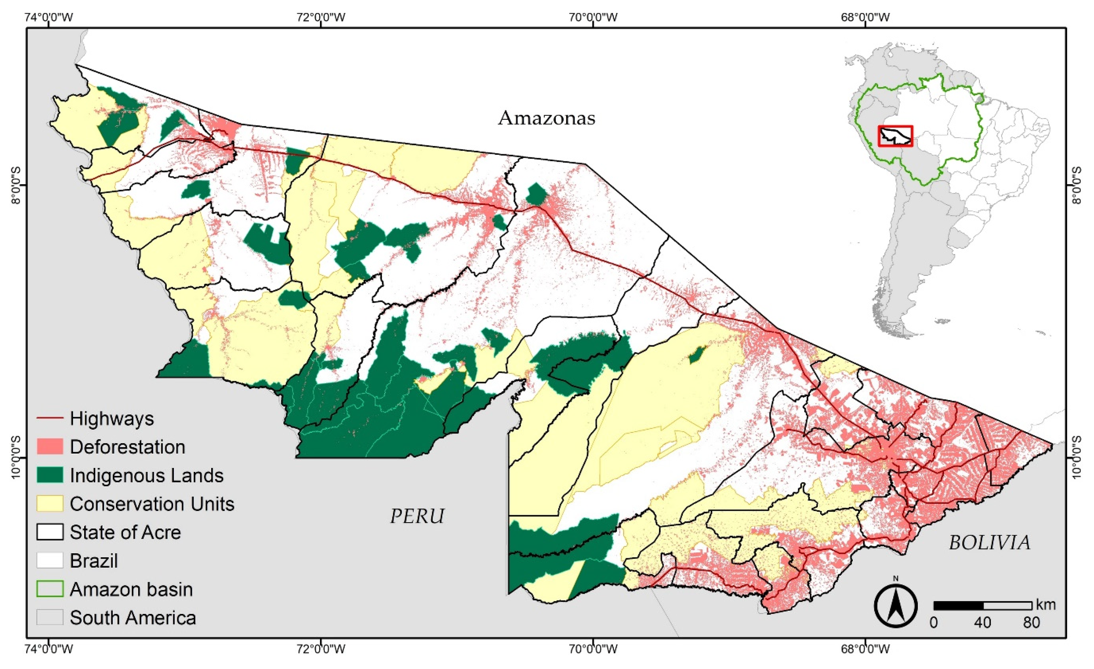
2.1. Characterization of the Study Area
2.2. Road Identification, Mapping, and Analysis
2.3. Road Growth Characterization in Terms of Land-Tenure and Municipalities
2.4. Relationship of Roads and Deforestation
3. Results
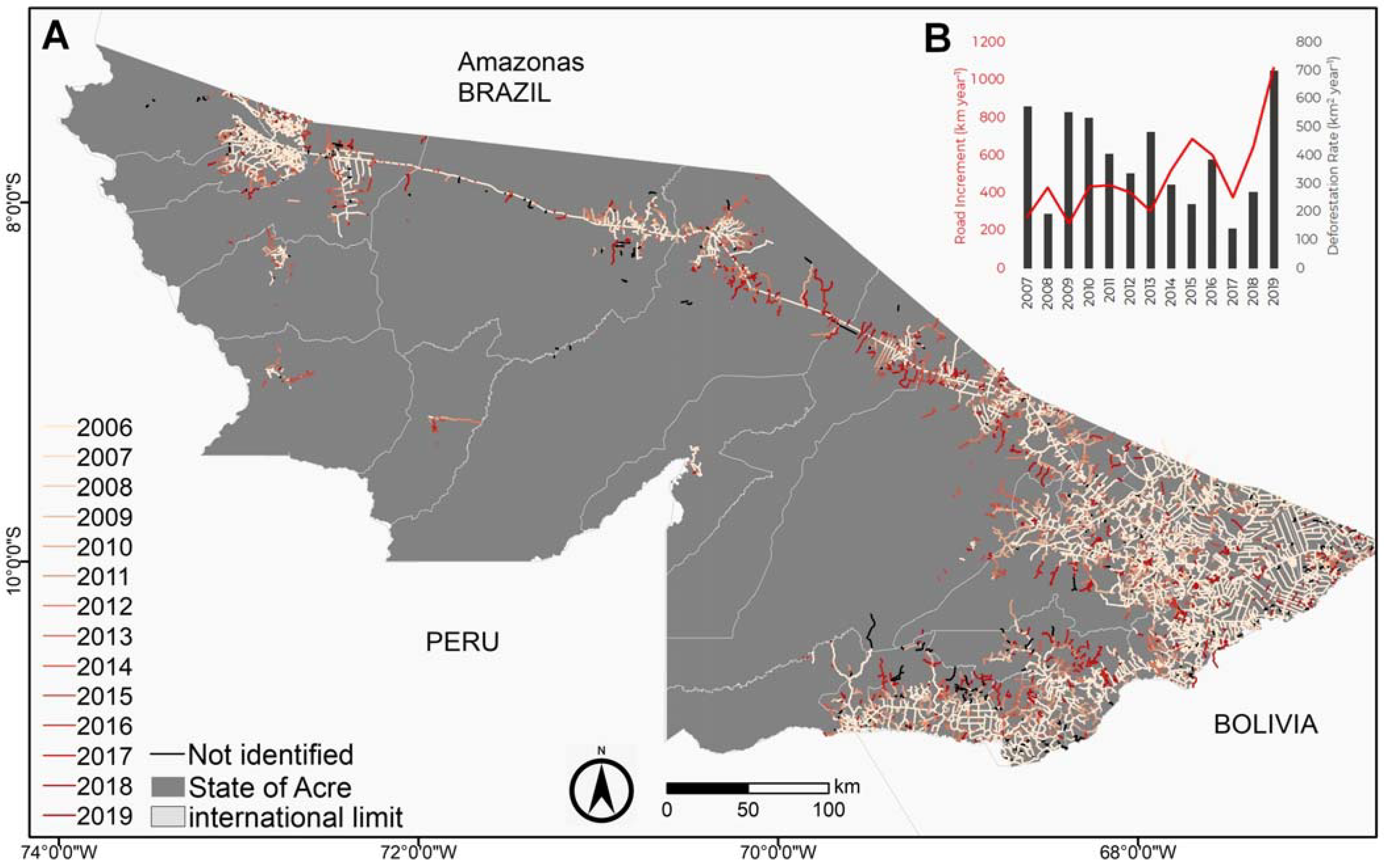
3.1. Roads in Acre
3.2. Distribution of Roads among the Municipalities of Acre
3.3. Distribution of Roads among Land-Tenure Categories in Acre
3.4. Deforestation and Roads
4. Discussion
4.1. Road Mapping in the Southwestern Amazon: Advances and Limitations
4.2. Increase in Roads in the Southwestern Amazon
4.3. Roads and Deforestation
5. Conclusions
Supplementary Materials
Author Contributions
Funding
Institutional Review Board Statement
Informed Consent Statement
Data Availability Statement
Acknowledgments
Conflicts of Interest
References
- Barni, P.E.; Fearnside, P.M.; Graça, P.M.L.d.A. Simulating Deforestation and Carbon Loss in Amazonia: Impacts in Brazil’s Roraima State from Reconstructing Highway BR-319 (Manaus-Porto Velho). Environ. Manag. 2014, 55, 259–278. [Google Scholar] [CrossRef] [PubMed]
- Laurance, W.F.; Albernaz, A.K.M.; Schroth, G.; Fearnside, P.M.; Bergen, S.; Venticinque, E.M.; Da Costa, C. Predictors of Deforestation in the Brazilian Amazon. J. Biogeogr. 2002, 29, 737–748. [Google Scholar] [CrossRef] [Green Version]
- Ferrante, L.; Fearnside, P.M. The Amazon’s Road to Deforestation. Science 2020, 369, 634. [Google Scholar] [CrossRef] [PubMed]
- Fearnside, P.M. A tomada de decisão sobre grandes estradas amazônicas. In Destruição e Conservação da Floresta Amazônica; INPA: Manaus, Brazil, 2019; Volume 1, pp. 327–337. [Google Scholar]
- Fearnside, P.M.; Laurance, W.F. Infraestrutura na Amazônia: As lições dos planos plurianuais. Cad. CRH 2012, 25, 87–98. [Google Scholar] [CrossRef] [Green Version]
- Armenteras, D.; Barreto, J.S.; Tabor, K.; Molowny, R.; Retana, J. Changing Patterns of Fire Occurrence in Proximity to Forest Edges, Roads and Rivers between NW Amazonian Countries. Biogeosci. Discuss. 2017, 2017, 1–29. [Google Scholar] [CrossRef] [Green Version]
- Cardille, J.A.; Ventura, S.J.; Turner, M.G. Environmental and Social Factors Influencing Wildfires in the Upper Midwest, United States. Ecol. Appl. 2001, 11, 111–127. [Google Scholar] [CrossRef]
- Rivero, S.; Almeida, O.; Ávila, S.; Oliveira, W. Pecuária e desmatamento: Uma análise das principais causas diretas do desmatamento na Amazônia. Nova Econ. 2009, 19, 41–66. [Google Scholar] [CrossRef]
- Barber, C.P.; Cochrane, M.A.; Souza, C.M., Jr.; Laurance, W.F. Roads, Deforestation, and the Mitigating Effect of Protected Areas in the Amazon. Biol. Conserv. 2014, 177, 203–209. [Google Scholar] [CrossRef]
- Ferreira, L.V.; Venticinque, E.; Almeida, S. O Desmatamento Na Amazônia e a Importância Das Áreas Protegidas. Estud. Av. 2005, 19, 157–166. [Google Scholar] [CrossRef] [Green Version]
- Soares-Filho, B.; Alencar, A.; Nepstad, D.; Cerqueira, G.; Vera Diaz, M.d.C.; Rivero, S.; Solórzano, L.; Voll, E. Simulating the Response of Land-Cover Changes to Road Paving and Governance along a Major Amazon Highway: The Santarém–Cuiabá Corridor. Glob. Chang. Biol. 2004, 10, 745–764. [Google Scholar] [CrossRef]
- Fearnside, P.M.; Graça, P.M.L.d.A. BR-319: Brazil’s Manaus-Porto Velho Highway and the Potential Impact of Linking the Arc of Deforestation to Central Amazonia. Environ. Manag. 2006, 38, 705–716. [Google Scholar] [CrossRef] [PubMed]
- Brandão, A.O., Jr.; Souza, C.M., Jr. Mapping Unofficial Roads with Landsat Images: A New Tool to Improve the Monitoring of the Brazilian Amazon Rainforest. Int. J. Remote Sens. 2006, 27, 177–189. [Google Scholar] [CrossRef]
- Lian, R.; Wang, W.; Mustafa, N.; Huang, L. Road Extraction Methods in High-Resolution Remote Sensing Images: A Comprehensive Review. IEEE J. Sel. Top. Appl. Earth Obs. Remote Sens. 2020, 13, 5489–5507. [Google Scholar] [CrossRef]
- Maboudi, M.; Amini, J.; Malihi, S.; Hahn, M. Integrating Fuzzy Object Based Image Analysis and Ant Colony Optimization for Road Extraction from Remotely Sensed Images. ISPRS J. Photogramm. Remote Sens. 2018, 138, 151–163. [Google Scholar] [CrossRef]
- Hinz, S.; Baumgartner, A. Automatic Extraction of Urban Road Networks from Multi-View Aerial Imagery. ISPRS J. Photogramm. Remote Sens. 2003, 58, 83–98. [Google Scholar] [CrossRef]
- Li, Y.; Briggs, R. Automatic Extraction of Roads from High Resolution Aerial and Satellite Images with Heavy Noise. Int. J. Comput. Inf. Eng. 2009, 3, 1571–1577. [Google Scholar]
- Kleinschroth, F.; Laporte, N.; Laurance, W.F.; Goetz, S.J.; Ghazoul, J. Road Expansion and Persistence in Forests of the Congo Basin. Nat. Sustain. 2019, 2, 628–634. [Google Scholar] [CrossRef]
- Ahmed, S.E.; Souza, C.M.; Riberio, J.; Ewers, R.M. Temporal Patterns of Road Network Development in the Brazilian Amazon. Reg. Environ. Chang. 2013, 13, 927–937. [Google Scholar] [CrossRef]
- Nascimento, E.d.S.; de Almeida, M.R.N.; Souza, G.d.C.; Silva, S.S. Dinâmica Da Expansão de Estradas e Desmatamento No Município de Cruzeiro Do Sul, Acre, Brazil; GALOÁ: Campinas, Brazil, 2019; Volume 17. [Google Scholar]
- Inpe. Project PRODES—Monitoring of the Brazilian Amazon Forest by Satellite. 2020. Available online: http://www.obt.inpe.br/prodes/ (accessed on 21 January 2021).
- Congalton, R.G.; Green, K. Assessing the Accuracy of Remotely Sensed Data: Principles and Practices, 2nd ed.; CRC Press: Boca Raton, FL, USA, 2008; ISBN 978-0-429-14397-7. [Google Scholar]
- Acre. Zoneamento Ecológico-Econômico Do Estado Do Acre: Fase II (Escala 1:250.000), 2nd ed.; SEMA: Rio Branco, Brazil, 2010. [Google Scholar]
- Ibge. Municipal Boundaries Limits. 2016. Available online: https://mapas.ibge.gov.br/bases-e-referenciais/bases-cartograficas/malhas-digitais.html (accessed on 21 January 2021).
- Zhang, Z.; Liu, Q.; Wang, Y. Road Extraction by Deep Residual U-Net. IEEE Geosci. Remote Sens. Lett. 2018, 15, 749–753. [Google Scholar] [CrossRef] [Green Version]
- Fearnside, P.M. Brazil’s Cuiabá- Santarém (BR-163) Highway: The Environmental Cost of Paving a Soybean Corridor Through the Amazon. Environ. Manag. 2007, 39, 601. [Google Scholar] [CrossRef]
- Laurance, S.G.W.; Stouffer, P.C.; Laurance, W.F. Effects of Road Clearings on Movement Patterns of Understory Rainforest Birds in Central Amazonia. Conserv. Biol. 2004, 18, 1099–1109. [Google Scholar] [CrossRef]
- Vilela, T.; Harb, A.M.; Bruner, A.; Arruda, V.L.d.S.; Ribeiro, V.; Alencar, A.A.C.; Grandez, A.J.E.; Rojas, A.; Laina, A.; Botero, R. A Better Amazon Road Network for People and the Environment. Proc. Natl. Acad. Sci. USA 2020, 117, 7095–7102. [Google Scholar] [CrossRef] [PubMed] [Green Version]
- Silveira, M.V.F.; Petri, C.A.; Broggio, I.S.; Chagas, G.O.; Macul, M.S.; Leite, C.C.S.S.; Ferrari, E.M.M.; Amim, C.G.V.; Freitas, A.L.R.; Motta, A.Z.V.; et al. Drivers of Fire Anomalies in the Brazilian Amazon: Lessons Learned from the 2019 Fire Crisis. Land 2020, 9, 516. [Google Scholar] [CrossRef]
- Silva Junior, C.H.L.; Aragão, L.E.O.C.; Anderson, L.O.; Fonseca, M.G.; Shimabukuro, Y.E.; Vancutsem, C.; Achard, F.; Beuchle, R.; Numata, I.; Silva, C.A.; et al. Persistent Collapse of Biomass in Amazonian Forest Edges Following Deforestation Leads to Unaccounted Carbon Losses. Sci. Adv. 2020, 6, eaaz8360. [Google Scholar] [CrossRef] [PubMed]
- Silva Junior, C.; Aragão, L.; Fonseca, M.; Almeida, C.; Vedovato, L.; Anderson, L. Deforestation-Induced Fragmentation Increases Forest Fire Occurrence in Central Brazilian Amazonia. Forests 2018, 9, 305. [Google Scholar] [CrossRef] [Green Version]
- Bullock, E.L.; Woodcock, C.E.; Souza, C.; Olofsson, P. Satellite-based Estimates Reveal Widespread Forest Degradation in the Amazon. Glob. Chang. Biol. 2020, 26, 2956–2969. [Google Scholar] [CrossRef]
- Matricardi, E.A.T.; Skole, D.L.; Costa, O.B.; Pedlowski, M.A.; Samek, J.H.; Miguel, E.P. Long-Term Forest Degradation Surpasses Deforestation in the Brazilian Amazon. Science 2020, 369, 1378–1382. [Google Scholar] [CrossRef]
- Gomes, C.V.A.; Perz, S.G.; Vadjunec, J.M. Convergence and Contrasts in the Adoption of Cattle Ranching: Comparisons of Smallholder Agriculturalists and Forest Extractivists in the Amazon. J. Lat. Am. Geogr. 2012, 11, 99–120. [Google Scholar] [CrossRef]
- Jardim, A. Estrada Do Pacífico Integra Economia e Cultura Com o Peru. 2013. Available online: https://agencia.ac.gov.br/estrada-do-pacifico-integra-economia-e-cultura-com-o-peru/ (accessed on 21 January 2021).
- Liberato, G., Jr. BR-319 Vai Impulsionar a Economia. 2017. Available online: https://www.diariodaamazonia.com.br/br-319-vai-impulsionar-economia/ (accessed on 21 January 2021).
- Silva, A. Acre e Peru Assinam Declaração de Interesse Pela Construção de Rodovia. 2019. Available online: https://agencia.ac.gov.br/aacre-e-peru-assinam-declaracao-de-interesse-pela-construcao-de-rodovia/ (accessed on 21 January 2021).
- Valdes, A. Conclusão Da BR-163, Um Sonho Realizado. 2020. Available online: https://valor.globo.com/agronegocios/noticia/2020/03/19/conclusao-da-br-163-um-sonho-realizado.ghtml (accessed on 21 January 2021).
- Baraloto, C.; Alverga, P.; Quispe, S.B.; Barnes, G.; Chura, N.B.; da Silva, I.B.; Castro, W.; da Souza, H.; de Souza Moll, I.E.; Del Alcazar Chilo, J.; et al. Effects of Road Infrastructure on Forest Value across a Tri-National Amazonian Frontier. Biol. Conserv. 2015, 191, 674–681. [Google Scholar] [CrossRef]
- Pfaff, A.; Robalino, J.; Lima, E.; Sandoval, C.; Herrera, L.D. Governance, Location and Avoided Deforestation from Protected Areas: Greater Restrictions Can Have Lower Impact, Due to Differences in Location. World Dev. 2014, 55, 7–20. [Google Scholar] [CrossRef]
- Nolte, C.; Agrawal, A. Linking Management Effectiveness Indicators to Observed Effects of Protected Areas on Fire Occurrence in the Amazon Rainforest. Conserv. Biol. 2013, 27, 155–165. [Google Scholar] [CrossRef] [Green Version]
- Pfaff, A.; Robalino, J.; Herrera, D.; Sandoval, C. Protected Areas’ Impacts on Brazilian Amazon Deforestation: Examining Conservation—Development Interactions to Inform Planning. PLoS ONE 2015, 10. [Google Scholar] [CrossRef] [PubMed]
- Stabile, M.C.C.; Guimarães, A.L.; Silva, D.S.; Ribeiro, V.; Macedo, M.N.; Coe, M.T.; Pinto, E.; Moutinho, P.; Alencar, A. Solving Brazil’s Land Use Puzzle: Increasing Production and Slowing Amazon Deforestation. Land Use Policy 2020, 91, 104362. [Google Scholar] [CrossRef]
- Keles, D.; Delacote, P.; Pfaff, A.; Qin, S.; Mascia, M.B. What Drives the Erasure of Protected Areas? Evidence from across the Brazilian Amazon. Ecol. Econ. 2020, 176, 106733. [Google Scholar] [CrossRef]
- Paiva, P.F.P.R.; Ruivo, M.d.L.P.; Silva Júnior, O.M.; Maciel, M.d.N.M.; Braga, T.G.M.; Andrade, M.M.N.; Santos Junior, P.C.; Rocha, E.S.; Freitas, T.P.M.; Leite, T.V.d.S.; et al. Deforestation in Protect Areas in the Amazon: A Threat to Biodiversity. Biodivers. Conserv. 2020, 29, 19–38. [Google Scholar] [CrossRef]
- Abessa, D.; Famá, A.; Buruaem, L. The Systematic Dismantling of Brazilian Environmental Laws Risks Losses on All Fronts. Nat. Ecol. Evol. 2019, 3, 510–511. [Google Scholar] [CrossRef] [PubMed]
- Ferrante, L.; Fearnside, P.M. Brazil’s New President and ‘Ruralists’ Threaten Amazonia’s Environment, Traditional Peoples and the Global Climate. Environ. Conserv. 2019, 46, 261–263. [Google Scholar] [CrossRef]
- Pereira, E.J.d.A.L.; Ferreira, P.J.S.; Ribeiro, L.C.d.S.; Carvalho, T.S.; Pereira, H.B.d.B. Policy in Brazil (2016–2019) Threaten Conservation of the Amazon Rainforest. Environ. Sci. Policy 2019, 100, 8–12. [Google Scholar] [CrossRef]


| Municipality | Municipality Area (km2) | Total Length of Roads (km) | Length 2007–2019 (km) | Density (km km−2) | Annual Increment (km) |
|---|---|---|---|---|---|
| Rio Branco | 8830 | 2669 | 1146 | 0.30 | 95 |
| Sena Madureira | 23,737 | 1587 | 944 | 0.07 | 73 |
| Xapuri | 5344 | 1406 | 725 | 0.26 | 56 |
| Bujari | 3033 | 1268 | 531 | 0.42 | 41 |
| Brasiléia | 3913 | 1249 | 548 | 0.32 | 42 |
| Senador Guiomard | 2321 | 1235 | 151 | 0.53 | 12 |
| Porto Acre | 2604 | 1176 | 229 | 0.45 | 18 |
| Cruzeiro do Sul | 8810 | 1113 | 375 | 0.13 | 29 |
| Plácido de Castro | 1943 | 1106 | 148 | 0.57 | 11 |
| Feijó | 27,982 | 1057 | 636 | 0.04 | 49 |
| Acrelândia | 1809 | 1018 | 232 | 0.56 | 18 |
| Capixaba | 1702 | 873 | 306 | 0.51 | 24 |
| Epitaciolândia | 1654 | 756 | 301 | 0.46 | 23 |
| Tarauacá | 20,192 | 744 | 300 | 0.04 | 23 |
| Rodrigues Alves | 3091 | 677 | 224 | 0.22 | 17 |
| Manoel Urbano | 10,628 | 580 | 413 | 0.05 | 34 |
| Assis Brasil | 4972 | 391 | 144 | 0.08 | 11 |
| Mâncio Lima | 5481 | 355 | 92 | 0.06 | 7 |
| Porto Walter | 6466 | 154 | 97 | 0.02 | 7 |
| Marechal Thaumaturgo | 8216 | 86 | 58 | 0.01 | 4 |
| Jordão | 5367 | 61 | 58 | 0.01 | 4 |
| Santa Rosa do Purus | 6144 | 60 | 7 | 0.01 | 1 |
| Total | 164,240 | 19,620 | 7665 |
Publisher’s Note: MDPI stays neutral with regard to jurisdictional claims in published maps and institutional affiliations. |
© 2021 by the authors. Licensee MDPI, Basel, Switzerland. This article is an open access article distributed under the terms and conditions of the Creative Commons Attribution (CC BY) license (http://creativecommons.org/licenses/by/4.0/).
Share and Cite
Nascimento, E.d.S.; Silva, S.S.d.; Bordignon, L.; Melo, A.W.F.d.; Brandão, A., Jr.; Souza, C.M., Jr.; Silva Junior, C.H.L. Roads in the Southwestern Amazon, State of Acre, between 2007 and 2019. Land 2021, 10, 106. https://doi.org/10.3390/land10020106
Nascimento EdS, Silva SSd, Bordignon L, Melo AWFd, Brandão A Jr., Souza CM Jr., Silva Junior CHL. Roads in the Southwestern Amazon, State of Acre, between 2007 and 2019. Land. 2021; 10(2):106. https://doi.org/10.3390/land10020106
Chicago/Turabian StyleNascimento, Eric de Souza, Sonaira Souza da Silva, Leandra Bordignon, Antonio Willian Flores de Melo, Amintas Brandão, Jr., Carlos M. Souza, Jr., and Celso H. L. Silva Junior. 2021. "Roads in the Southwestern Amazon, State of Acre, between 2007 and 2019" Land 10, no. 2: 106. https://doi.org/10.3390/land10020106