Article

Designing the Adaptive Landscape: Leapfrogging Stacked Vulnerabilities

1
Cittaideale, Office for Adaptive Design and Planning, 6706 LC Wageningen, The Netherlands
2
Institute for Culture and Society, Western Sydney University, Parramatta, NSW 2124, Australia
3
Urban Ecology and Ecocities Lab, Faculty of Architecture, Delft University of Technology, 2628 BL Delft, The Netherlands
4
Faculty of Architecture, Delft University of Technology, 2628 BL Delft, The Netherlands
*
Author to whom correspondence should be addressed.
Land 2021, 10(2), 158; https://doi.org/10.3390/land10020158
Submission received: 8 January 2021 / Revised: 27 January 2021 / Accepted: 2 February 2021 / Published: 4 February 2021
(This article belongs to the Section Urban Contexts and Urban-Rural Interactions)

Abstract

:
In the Anthropocene, climate impacts are expected to fundamentally change the way we live in, and plan and design for, our cities and landscapes. Long-term change and uncertainty require a long view, while current planning approaches and policy making are mostly short-term oriented and are therefore not well suited to respond adequately. The path-dependency it implies causes an irresolvable dilemma between short-term effect and long-term necessities. The objective of the research is to investigate an alternative planning and design approach which is able to overcome the current constraints and take a holistic long-term perspective. Therefore, the methods used in the study underpin a creative process of future visioning through backcasting and finding a dynamic equilibrium in the past as a primer for long-term climate adaptation. This way, the individual vulnerabilities of current sectoral policies can be leapfrogged and integrated into one intervention. This design-led method is applied to the northern landscape of the Groningen region in The Netherlands. This intervention is positioned as a re-dynamization of the landscape by re-establishing the exchange between the land and the sea. The findings in the study show that a long-term perspective on the future of the regional landscape increases climate adaptation and enriches the opportunities for viable agriculture, increased biodiversity, and a raised land that is not only protected against possible storm surges, but benefits from the sediments the sea brings. The economic analysis shows that a new perspective for farming within saline conditions is profitable on a fraction of the land, the biodiversity can be enriched by more than 75%, and the ground level of the landscape can be raised by one meter or more in the next 50–100 years. Moreover, the study shows how a long-term perspective can be implemented in logic stages that comply with the natural step-changes occurring in climate change.

1. Introduction

It is widely substantiated that global climate change is taking place [1], and this is, at least for an important part, caused by the way humans live in the so-called Anthropocene [2]. This change impacts on a range of aspects that even further compromise a sustainable existence on the planet. The impact on land use, productivity and food security [3], ecology [4], livability [5,6,7], and safety under pressure as result of a potential accelerated sea level rise [8,9], is claimed to even move beyond the planetary boundaries [10]. In this research, it is investigated whether current policy responses sufficiently deal with this uncertain and potentially dangerous future. The need to adapt to the impacts of climate change is evident [11,12].
Existing planning approaches tend to focus on the recent past, repeating how policies responded to what has been experienced before, and formulating copies of policies for new or unknown problems [13,14]. Generally, this is counterproductive, as one cannot solve new problems with the solutions that are rooted in the cause of the problem. Research has shown that current policies for the Groningen region tend to ‘muddle through’ [15], as these focus on the near future and well-understood problems [16,17].
Instead, a climate adaptative future requires an innovative plan, which is capable of bypassing the short term to overcome the path-dependency of recent history. In this article, we focus on three aspects that are profoundly under pressure as a result of climate change in the Groningen context, e.g., the growth food, the protection of the coast and its Hinterland, and ecology. Each of these are vulnerable in themselves, however, when in combination, stacked vulnerabilities lead to complexity, even wickedness, hence to unprecedented interactions and uncertain outcomes. Coping with uncertainty [18] is therefore essential, and the focus in this research emphasizes the longer term and looks holistically at future developments. This gives reason to replace short term spatial policymaking by applying the art of the long view [19] and introduces forms of unsafe planning [20], which allows for the courage to leapfrog existing policies, to dive into uncharted territories, and to dare to dream the future. Leapfrogging implies jumping over the next available policies and overcoming the constraints of the near future by inventing long-term solutions that solve current and future problems at the same time. A good example is the increase of connectivity in many African countries by shifting to mobile telephones without first constructing a landline network. In this study, backcasting methods are used to imagining the solutions of the future, overcoming the solutions that were to be implemented to deal with current problems.
The perspective is taken to view climate adaptation as a spatial challenge [21] and positioning ‘design’ as the primer for finding holistic solutions [22,23,24]. This way, by design, the implications of an adaptive landscape are exemplified for the northern Groningen area in The Netherlands. The Groningen area is chosen as the area of study because here many actual problems collide, from sea level rise and salinity, the risk of flooding and degrading agriculture, and loss of biodiversity, to declining economic and social wellbeing. Additionally, the Groningen area has to deal with soil subsidence as a result of gas extractions, and a large body of knowledge is available on agriculture, climate adaptation, energy, and ecology. Moreover, the Global Centre on Adaptation is located in the City of Groningen, on the University campus, and this research project has been part of the so-called design-manifestation of the Climate Adaptation Week Groningen (https://klimaatadaptatiegroningen.nl/en/climate-adaptation/week), in which the task is to conceive a design for a long-term future with a 100-years perspective.
This article digs into the process and methodology of how to leapfrog current stacks of vulnerabilities in order to overcome path-dependency, how a long-term perspective can be conceptualized, and what the benefits of such a holistic viewpoint hold.

2. Problem Definition

The northern part of the Groningen landscape can be divided in a couple of typical zones (Figure 1). In the north, the area bounds the intertidal landscape of the Wadden Sea and the salt marshes. The area behind the northern dikes is a relatively large-scale and open, efficient landscape used for agriculture. It is, for the Dutch context, a little higher above sea level than the southern part, at maximum 1.5 m above current mean sea level. The southern zone, just north of the relatively urban area of the City of Groningen, is a landscape of cultural heritage, middle to small scale, and also in use for agriculture. This zone is relatively low-lying and in a process of subsiding, at current sea level or below. The main crops in the landscape are wheat (in the north), sugar beet, and grassland. The focus of the research presented here relates to the entire landscape, from the city to the sea.

2.1. Problem Exploration
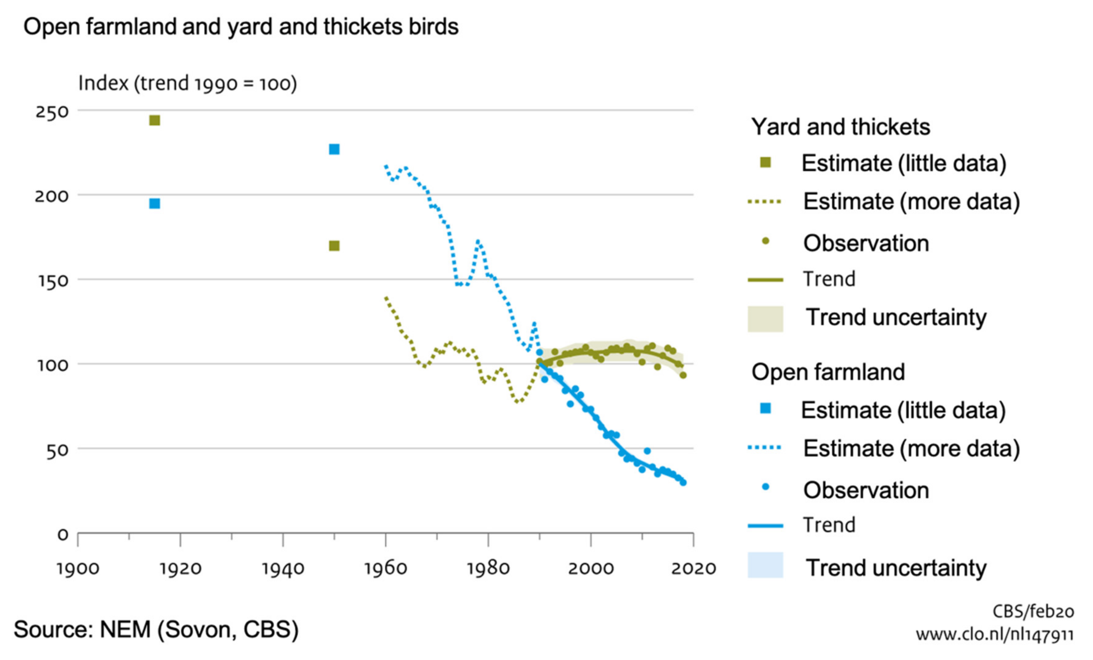
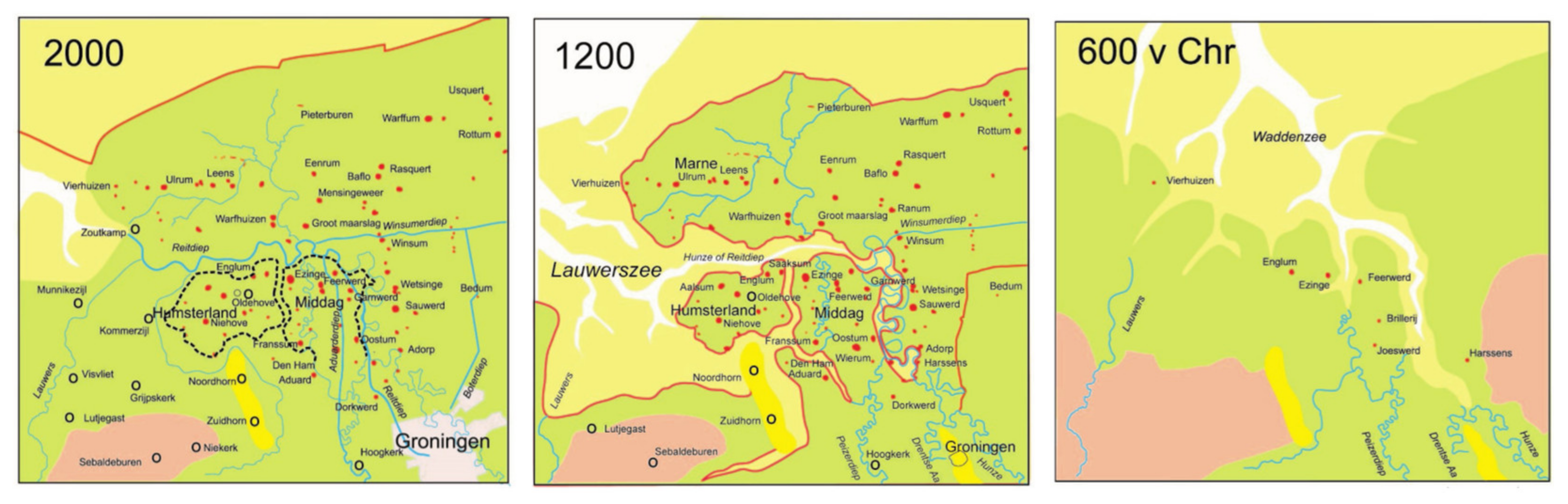
In the Groningen landscape, specific problems related to ecology, agriculture, and the protection against flooding are identified. These themes play a major role in the current existence of the functionalities of the landscape, however, they are also vulnerable each in their own right. Climate change exaggerates the problems on the long term, and the interplay of these three themes is therefore taken as the context for the research project.

2.1.1. Ecology

In the Groningen landscape, as in the entire country, the vulnerability of nature increased over time. The worldwide decrease of biodiversity, up to 68% [25], has also become apparent in the north of The Netherlands, increasingly solely consisting of grassland, arable land, ditches, and roads needed for transportation of agricultural products. The loss of diversity [26] has a negative impact on the health of the soil and water quality. This eventually causes difficulties for all kinds of natural processes to function as they should or could. In general nature reserves are too small to keep biodiversity up to minimal levels, and water management and nutritional flows are servicing agriculture, which means their precisely controlled dewatering and fertilizing stands in the way of natural processes self-regulating.
In The Netherlands, the populations of the black-tailed godwit, redshank, oystercatcher, and lapwing were, in 2007, 10–60% lower than in 1990 [27]. Although a range of measures were implemented in the 1990s, the decrease in open farmland birds has not stopped (Figure 2). For instance, the reduction in numbers of black-tailed godwit of approximately 40% is of international importance, since The Netherlands is the major area for the breeding population in Europe [28]. This is strongly related to agricultural practices. In particular, after 1960, the trend continuously went downward as result of intensified farmland and cattle farming. Moreover, breeding grounds are reduced due to expansion of urban areas, infrastructure, and traffic [27].
Can nature still be saved? The loss of biodiversity since the second half of last century is staggeringly high. Furthermore, this umbilical cord cannot be severed, as our own lives are dependent on the natural system. Instead of trying to protect nature, it should be given more space in the form of larger ecosystems with humans as part of nature as opposed to vice versa.

2.1.2. Agriculture

The current agricultural system in Groningen relies heavily on a few crops: Potatoes, wheat and sugar beet, and grassland [29]. In order to make agriculture possible in the peat-like grounds of Groningen, the landscape needs to be dewatered, causing a substantial carbon emission of approximately 40% of the total Groningen emissions from agriculture [30]. Most of the agricultural production is subsidized by the EU, and because of future reduction of these subsidies [31], the income of farmers in Groningen increasingly comes under pressure. Additionally, the global concerns around food security [32] could eventually lead to questions around export and transport of agricultural goods. With its focus on export, the Groningen agriculture is not capable of feeding its own population, as strange as it sounds, and it must therefore import food from around the globe. Food safety impacts pose another serious risk [33] for the way food is produced, as it may cause illnesses, epidemics, or pandemics. Global spread of these impacts may eventually lead to a more regional focus of food production to be better able to know what and how food is grown and prevent quality problems from emerging during transport. Due to dewatering agricultural grounds and relative sea level rise, the Groningen soil subsides and salinity increases [34]. Recent droughts [35] increase this problem, which is creating additional risks for the traditional fresh-water dependent crops.
Over the last century, agriculture in Groningen has undergone a transformation. As part of general developments in The Netherlands [36], land consolidation in the 20st century led to monocultures and larger scale parcels (Figure 3) which are more efficient, but also more vulnerable for illnesses and economic change.
This continuous ‘upscaling’ agriculture finds itself at an intersection: Following the existing pathway of increasing efficiency of production methods, using up all the natural resources and emaciating the landscape, or establishing agriculture in a way that the crops grow whilst enriching the soil, so nature remains healthy?

2.1.3. Flood Safety

With an accelerated sea level rise [8,9], there is pressure on the Dutch coast, and also the northern landscape is in danger. Sea level rise, in combination with the Groningen soil-subsidence, exaggerates the process of salinification and increases the risk of a potential flood. The process of embanking the northern coast, started around the year 800AC [37], has long been seen as the perfect remedy for protecting the Hinterland against flooding, but this also increases risk. Though embankments protect the land, natural processes are implicitly cut off by the artificiality of increasingly stronger and higher, engineered infrastructural elements. The change a dike breaks may be decreased, the impact of such a breech could be catastrophic. In Groningen, this scenario already unfolded in 2006 [38]. The adaptive capacity of the landscape to deal with sudden change, and potential disaster is very limited due to the inflexible way the land is organized. There is no room for flooding to find its way should a dike breech occur. Therefore, the old adage of building a higher and higher dike when the sea level rises is no longer sufficient. The way we think about water safety has progressed, and more and more often makes use of adaptive management of the water system [39]. Building with nature [40] is an accepted yet incidentally applied alternative for traditionally building coastal protection structures. It offers continual adaptiveness and resilience of the land through the self-organizing strengths that nature offers us.

2.1.4. Stacked Vulnerabilities

The interdependencies of flood food and ecology are substantial, yet the sectoral problems are generally treated in a singular way. This increases the risk of even larger problems, since stacked vulnerabilities and their interdepence cause a complexity of potential interactions that cannot be solved by responding to one issue on its own. Indeed, each of the three topics are currently ‘treated’ with a break with the natural process that established a healthy system initially, formed the landscape as the basis for nature, food production, and a natural protection against sea level rise and storm surges. These stacked vulnerabilities increase the risk for each of them, and for the entirety. Should one of the sectoral strategies fail, it could lead to a chain reaction of undesired developments, problems, and potentially disasters. For instance, when the ecological quality decreases, the soil becomes less healthy, which leads to lower agricultural production, which is compensated for by a more efficient water management and fertilization, leading to soil subsidence and higher risk of salinization and eventually flooding. This domino-effect illustrates an unexpected sequence of occurrences. The example is only one that is relatively predictable, but the complex interaction between the three systems may lead to unforeseeable problems. This process of deep uncertainty [41] is only intensified due to climate change and linear responses, rather than systemic ones.
Because the interactions between different aspects, especially when the future is uncertain, are unpredictable, the response to dig in sectoral solutions deeper and deeper is counterproductive. In the end, it deteriorates into single uses and has detrimental effects on the whole system, and hence requires the non-linearity of landscape as a complex, adaptive, system.

2.2. Problem Definition

Short term and sectoral policies lead to stacked vulnerabilities, forming a complex interaction and are inherently unpredictable, and thus may lead to surprises, unprecedented events, and unwelcome hazards. It increases the chance at further loss of biodiversity, increased food insecurity and unsafety, and raised risks at impactful flooding. Therefore, current short term and sectoral policies increase risks whilst aiming for the opposite.
The objective for this research is to develop a novel way of land-use planning, as an alternative based in adaptive planning and design, that offers a better opportunity to overcome stacked vulnerabilities to create a climate adaptive and resilient future on the long term. The question is how to respond to current problems, near future expectations, and simultaneously reduce vulnerability of the landscape on the long term.

3. Methodology

In order to investigate the research question, a methodological approach (Figure 4) is chosen that unites long- and short-term oriented methods, starting from a long-term and holistic perspective. The research process consists of the following stages:
0.
Analysis of current policies: Desk-top study on future healthy food demand, agricultural productivity and economic feasibility of future agriculture, and water requirements and availability. Based in existing sources, statistics, and predictions, problems are quantified.
1.
Developing a ‘long view’ [20], using methods such as futuring [42,43] and spatial visioning [44,45].
2.
Design of a holistic intervention, using a backtracking method [46], oriented at creating a (spatial) tipping point [47] that is able to change path-dependency and moves away from existing pathways and policies.
3.
Planning an integrated spatial future of the landscape, using backcasting methods [48,49] and scenario planning [50,51,52] to explore the corners of future predictions for the agricultural system (local vs. global), climate change (accelerated change vs. realizing the Paris agreement), and ecology (biodiversity loss vs. ecological regeneration).
4.
Design the thematic implications for food, ecology, and safety in a Research by Design [53,54,55,56,57,58] process, exploring the pros and cons of certain spatial interventions, and redesign based on these findings.
5.
Designing a staged process of implementing an adaptive future landscape making use of the moments in time that manifest themselves as crucial changes or bifurcation points [59,60,61,62], linked to the estimated step changes [63,64] in climate change.
The character of the applied methodology is design-led [22,23,24], bringing together three approaches to planning in an interactive way. Firstly, a collaborative and co-creative way of working in which experts and stakeholders contribute to the end-result in a design charrette context [65,66,67,68] is applied. Secondly, designerly explorations [69,70] are enhanced, which stimulate out-of-the-box thinking and creativity. Thirdly, an intensive interaction between design and analysis, allowing for analytical reflections to the design propositions, is established. In an interactive way, the questions derived from the design process are responded to by analytical research into agricultural productivity, future diet, and economic impacts, into ecological quality, gradients, saline and freshwater conditions, habitats, and land-forming and sedimentation.

4. Results

4.1. Current Policies
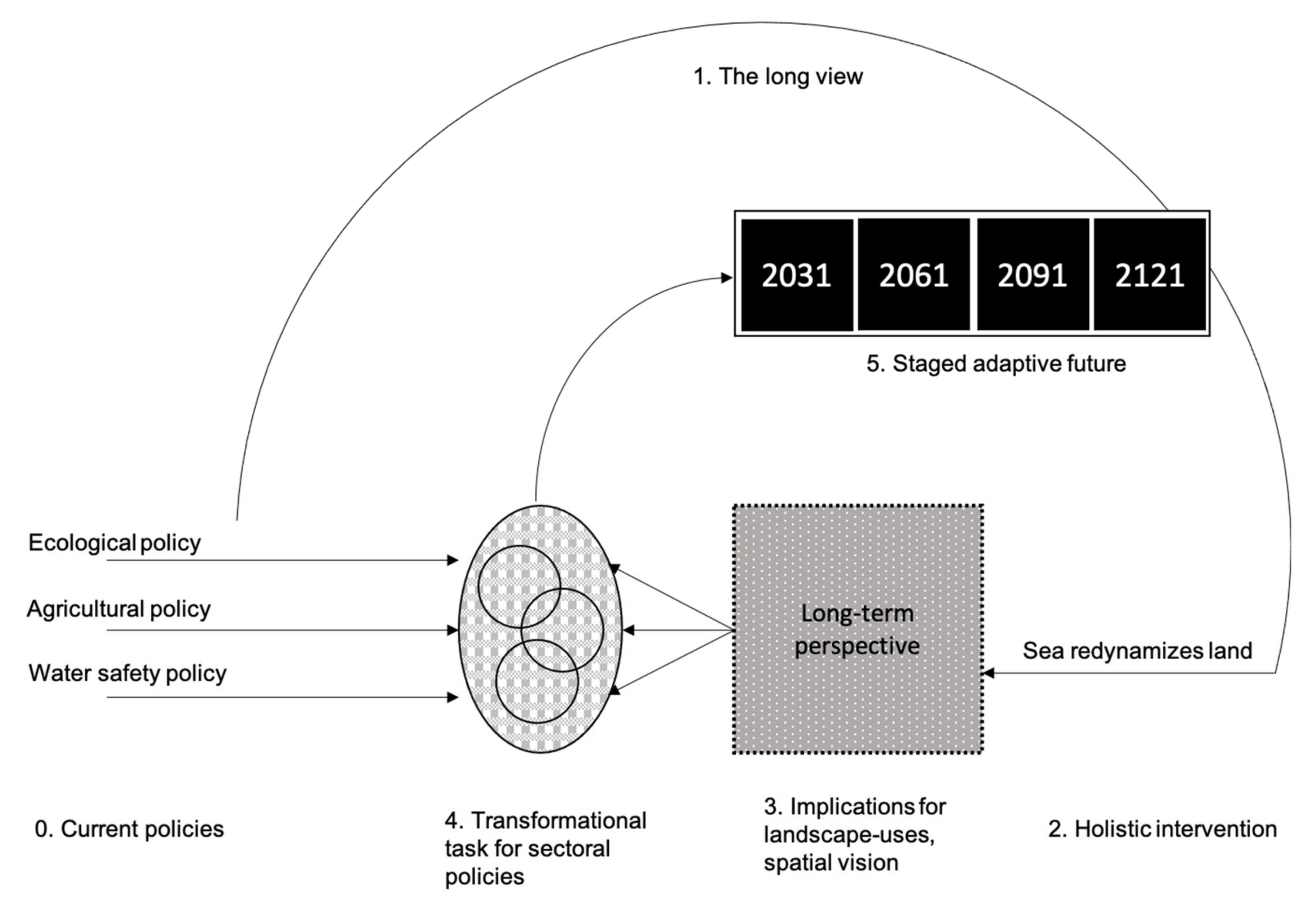
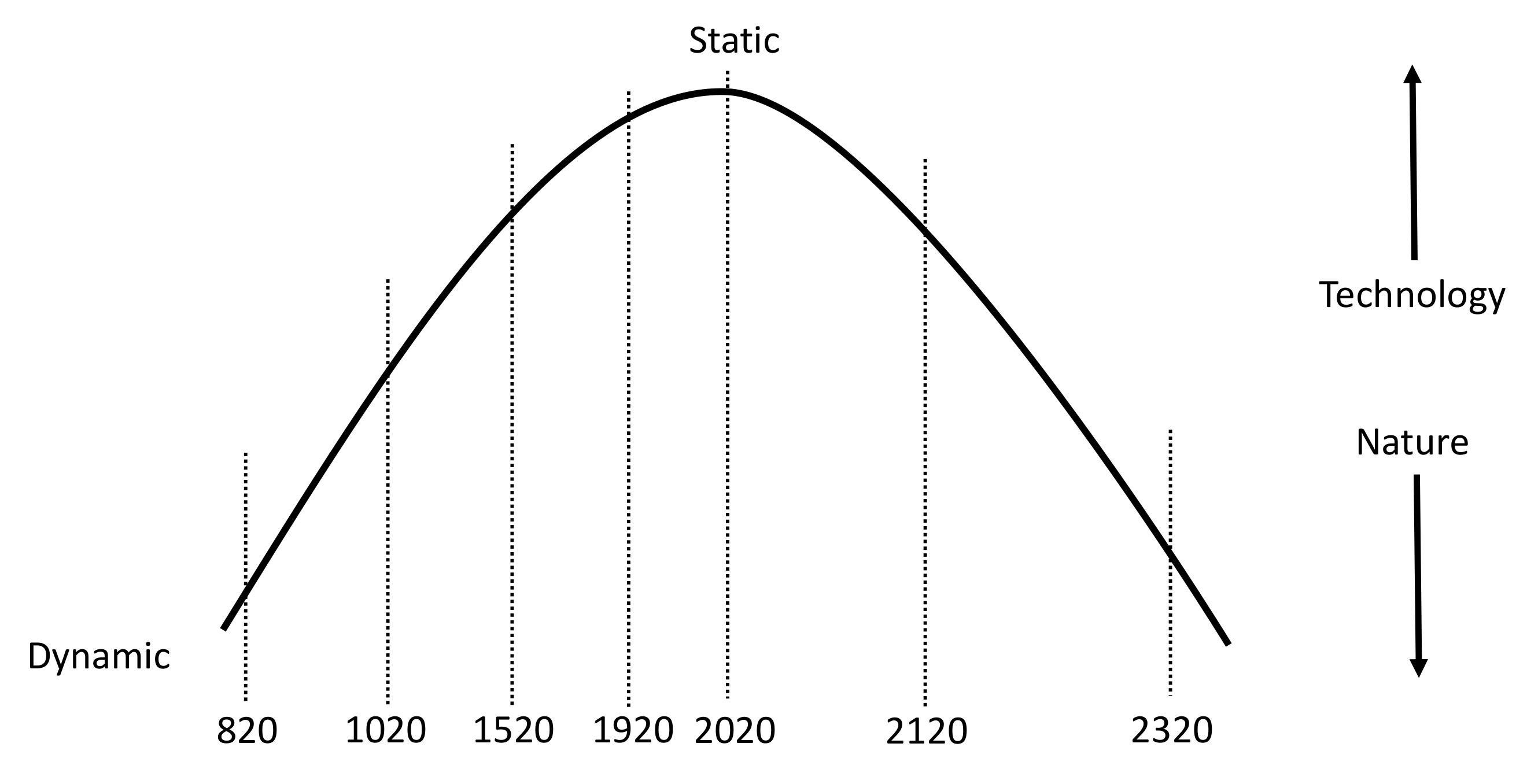
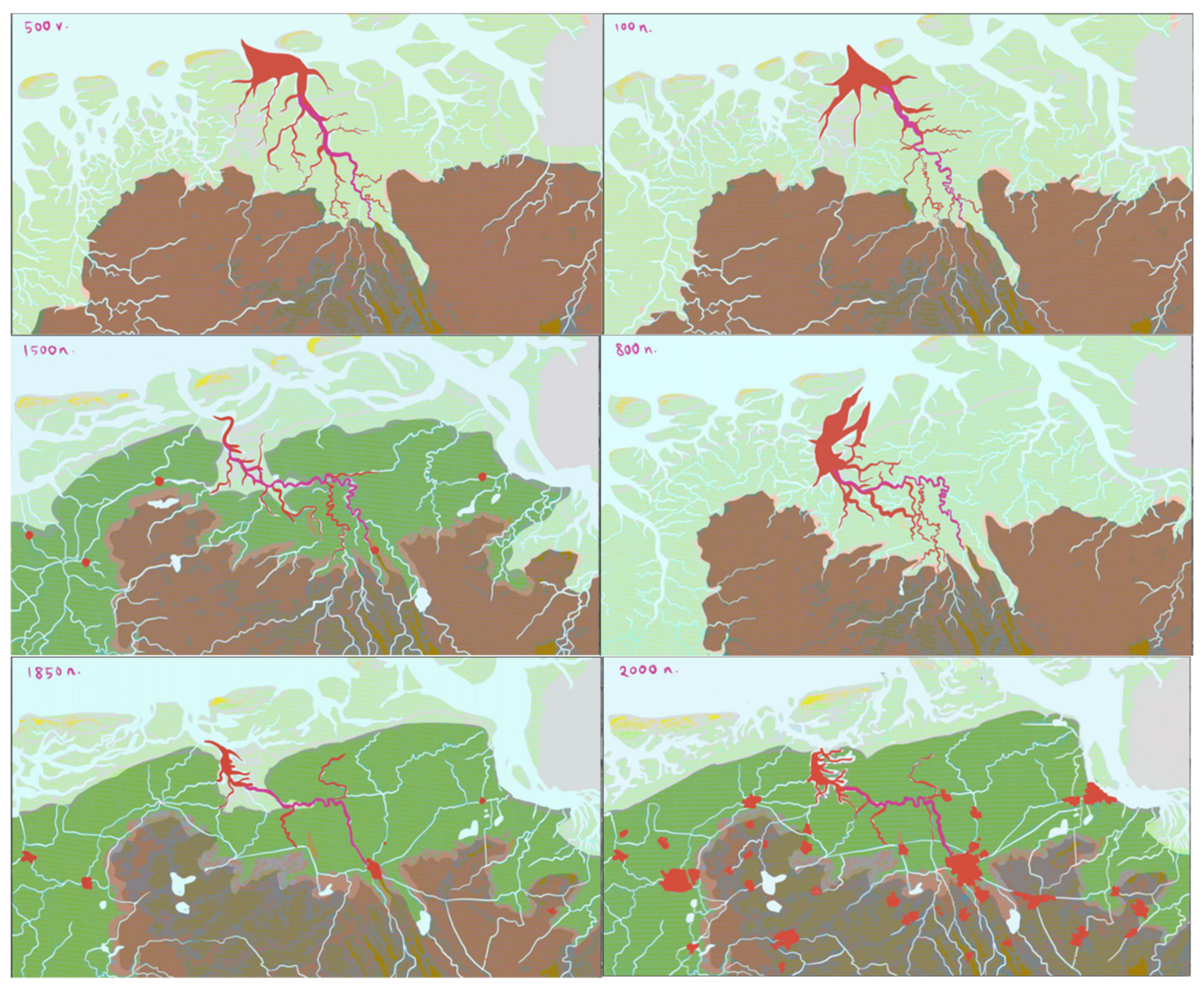
The interrelated fields of growing food, ecology, and the landscape have been separated by academic fields, policies, and subsidy frameworks. This has led to a functionalistic landscape in which highly specialized monocultures dominate the landscape and there is less and less space and time for ecosystems to mature. “Humans want quantity over quality, growth over development, production over protection–usually realised in the most inefficient ways. We turn mature ecosystems into monocultures–cultures of single species–which are the simplest of ecosystems. With our blinders on, we prioritise just one species, selected to grow fast–like cornfields in Iowa or salmon farms in the Chilean fjords–and we focus all our efforts on it to the detriment of any surrounding species. Although these monocultures are intended to feed us, ironically, they are the closest thing to a barren landscape when it comes to ecosystem maturity–the anti-climax” [71] (pp. 61–62). The consequences of this are severe and are felt in the Groningen context as well.
Continuation of subsidies to keep current farming alive at a marginal economic level could lead to bankruptcy for many farmers when EU subsidies end [31]. Current farming, as it focuses on the export of produce, is not capable of providing a balanced, climate resilient, and healthy diet to the Groningen population. Our analysis of a possible food system that would be able to provide this diet to everyone in the region concludes that there is enough space available (in, on and elevated, and attached to the built environment, and in the rural landscape) to grow the dietary needs [72]. However, water scarcity compromises the growth of sufficient crops on a yearly basis. The supply of water is running out, and there is no alternative [73]. The system requires more water to become self-reliant.
“We assume we know what is good for a species, but we forget that our landscape is so changed, so desperately impoverished, we may be recording a species not in its preferred habitat at all, but at the very limit of its range” [74] (p. 182). This is called the “Shifting Baseline Syndrome” [74] (p. 191). The current policies on nature preservation aim to protect and maintain current species by safeguarding relatively small areas. This cumulatively leads to reduction of the amounts of species in Groningen [26].
Historic analysis shows that the continuous process of embankment of the landscape has increased vulnerability for flooding [72]. The subsequent raising of dikes has made them stronger step-by-step, however, it also expelled the resilience out of the system to self-organize natural processes of land-forming. The impact of a dike break has become higher should it come to a flood.

4.2. The Long View

Nature is not that fun, but we have to do something with it [75]. This statement urges us to overcome the gap between human needs and the ecological conditions that provide us the basis for life. In a complex world, continuation on the business-as-usual pathway will not have a profound impact on determining a sustainable future. It is becoming clearer and clearer that “we have all ended up in a systemic labyrinth, and only those who see possibilities in unexpected events will have an impact and determine the future.” (paraphrased from: [76]). To get access to the unexpectedness of the future is the key in establishing a long view, that is responding to the main research question of how to create a spatial climate adaptive policy with a time-horizon of approximately 100 years.
The way we grow food has far-reaching consequences for ability of the natural system to persevere and regenerate. This ‘long view’ takes a diet that provides everyone with a healthy, nutritious menu, without overloading the Earth via climate change, social exploitation, or decline of biodiversity [77] as a starting point. Though the space required to grow the food for all inhabitants is in the Groningen context available, the water scarcity puts serious constraints on growing the needed produce and hence makes supply of water from elsewhere necessary. The coastal location offers the perfect solution through an infinite source of available water: The sea. Therefore, the long view on a climate adaptive landscape for the northern Groningen area takes this new connection of the land with the sea through a new inlet as the point of departure. This creates security for the perpetual presence of sufficient water to grow all agricultural produce needed to feed the inhabitants of the area.

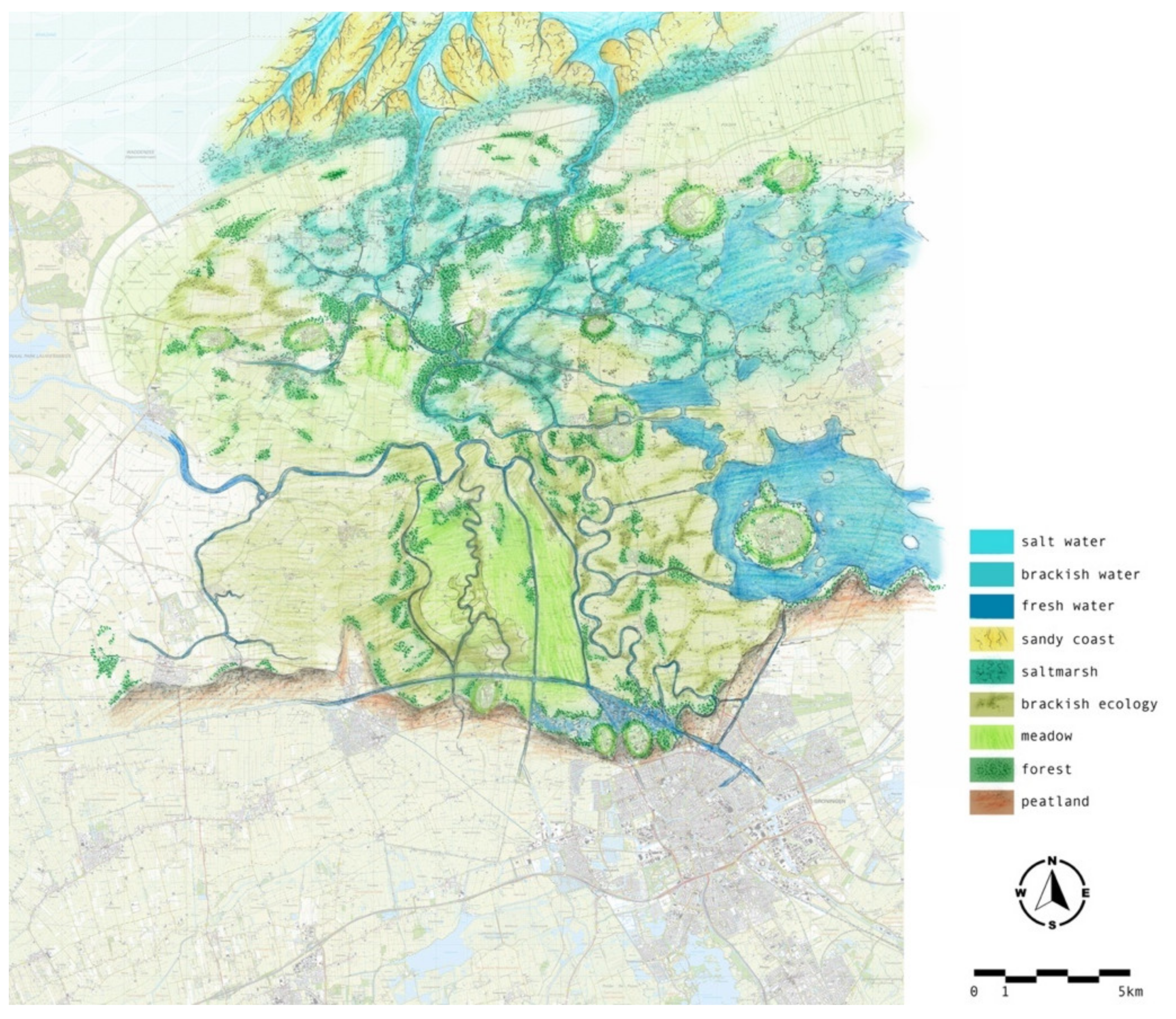
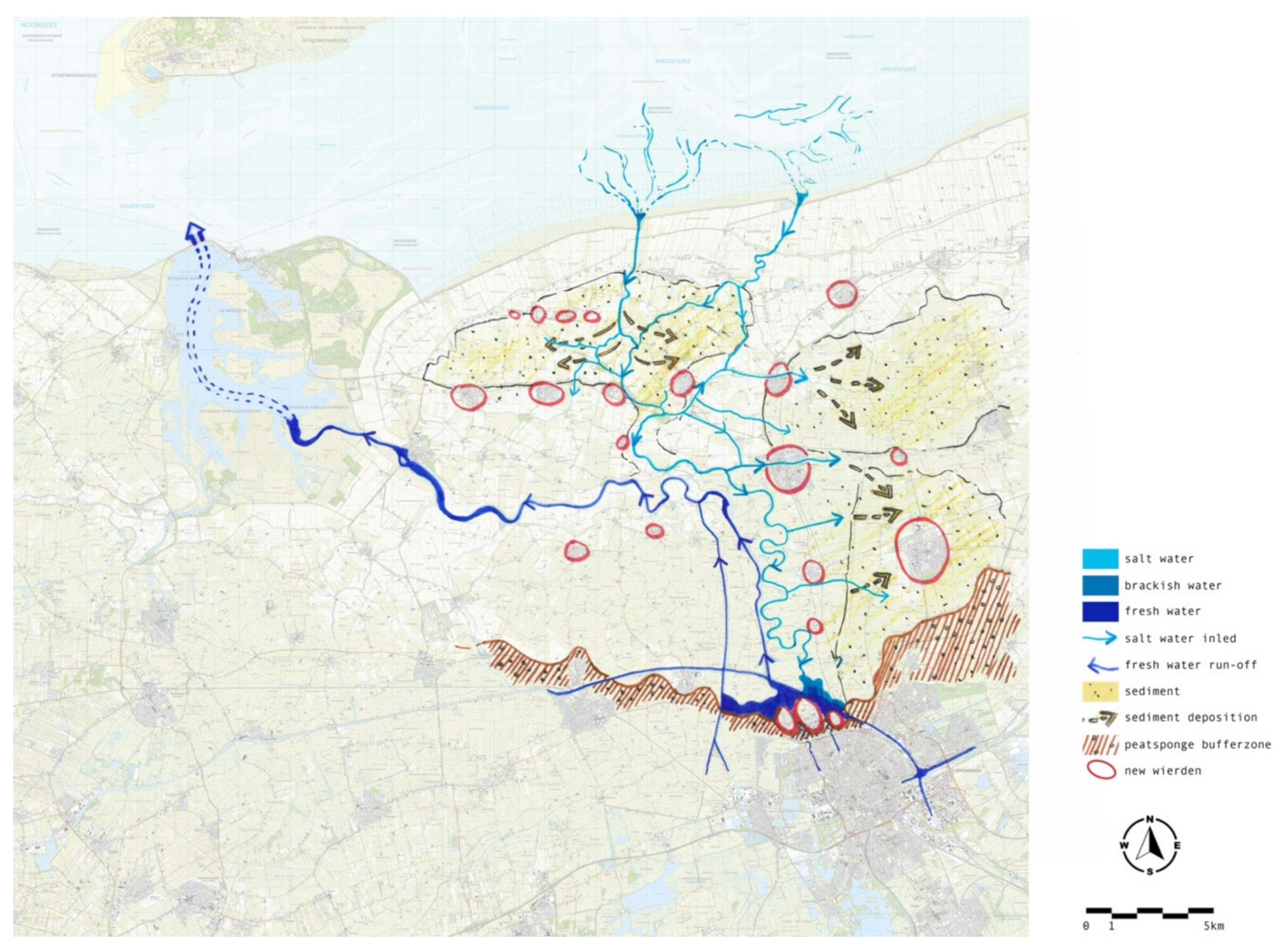
4.3. A Holistic Intervention and Integrated Spatial Vision

By taking the year 2121 is as the time horizon for policymaking, it offers the potential to integrate problem fields and uncertain dynamics. It also creates the freedom of thought to step out of the technical paradigm and move from the static system characteristics, as they are now, towards a natural dynamic future, resembling past self-reliance of a natural landscape (Figure 5). Looking at it from the long-term perspective, it is possible to see we encounter a potential tipping point [47] that turns the tide from ever-increasing technological statics to relying on nature’s dynamics. The installment of such a holistic intervention is chosen on the basis of an accelerated change in climate impacts, preluding the necessity of adapting to change in order to be able to continue living and growing the required food in this region. In itself, limiting climate change is important, however, in exploring future scenarios, this research has focused on the adaptation and planning opportunities, not so much on mitigation of climate change.
For the Groningen area, the tipping point discovered takes all vulnerabilities of the sectoral issues and turns these into one response solving all in one move. Re-dynamization of the landscape turns risks into safety, food-dependency into security, and loss of biodiversity into ecological gain. The holistic intervention is found by backtracking the Groninger landscape to a time in the past of a dynamic equilibrium, where a balance between time and tide (Figure 6) was working. Before 800AC, the historic landscape dynamics formed a dynamic interplay of freshwater discharge from the higher plateau, terraforming in the intertidal zone, and a continuous intrusion and retraction of sea water. Creeks connected the higher areas with the sea and found their way determined by the harder and softer parts in the landscape. The sediment that the sea brought inland allowed the land to grow, coping with changing sea levels. In parallel, large zones of raised bog were formed, tempering the powers of the sea, hence creating a safe coastal landscape.
Before 800AC, the Groningen land stood in direct contact with the sea (Figure 7). The saline creek penetrated deep into the landscape. After 800AC, people started small embankments to protect them from the regular tidal waters. During the 9th–12th century, men bounded the main creek to an east-west configuration that created several islands and peninsulas. Currently, the north Groningen landscape is closed off from the sea with a huge dike to protect the land against inundations.
The transformation from a natural dynamic equilibrium towards the current static situation is illustrated by the sequence of landscape transitions over time (Figure 8). The higher grounds in dark green and the peat in brown are dominant in the early stages, while the influence of saltwater (in red) creates the salt marshes (light green). Over time, the deposition of clay increases (dark green), and this reduces the intrusion of the seawater. After humans start to control and embank the land, agricultural activities emerge, as does urbanization. By the year 2000, a separation of land-based activities and the sea has become a divide.
The current managed landscape is non-resilient and provides safety by agreement. Real safety is debatable as a breakthrough of the strongest dike implies a huge disaster. The alternative of a nature-driven and self-organizing coastal system could prove less vulnerable if human control is replaced by the ecological system instead. This way the landscape itself establishes its protection in the form of salt marshes, raised bog, mangroves, and barrier islands, hence reducing vulnerability of the entire system. In this context, the current timeframe is the high mass of human control, which slowly transits into a dynamic nature-driven future.
The powers of the sea form and raise the land by bringing sediment and the saline inlet will start increasing the ground level of the land to enhance safety. In this dynamic environment, new creeks will be filled with water from the sea and determine a new, but constantly shifting, balance between land and sea. Simultaneously, longer droughts and more intense rain events demand a higher capacity to store freshwater, to be of use in drier periods. Slowing down the discharge of rainwater stimulates peat forming, eventually merging with salty marshes in a staged emergence of coastal dynamism. From the current separation, land and sea systems will first join in synapses before deep intrusion of the saltwater landscape in the freshwater system and vice versa will, in the end, cause a complete merge (Figure 9). Subsequent design principles guide this zoned transformation as ‘lines of protection’ (Table 1 and Figure 10).
By reintroducing coastal dynamics in the landscape (Figure 11), ecological gradients will be enhanced, from saline, to brackish, to freshwater conditions. This gradient will shift southward over time, when sea water gains more influence. The water that is brought deep in the landscape can be used for saline agri- and aquacultures, and creates a multi-layered coastal system, with terra forming, mangroves, ecological zoning, and water that overflows the land. The design of the new saline landscape is inspired by its historical context, as a flowing stream from the northern coast meandering inland. It connects old ‘forgotten’ river arms and re-establishes the stream so that water can start flowing in and out of the landscape.
The integration of current pressing problems preludes an emerging tipping point that brings about a connective solution that solves multiple problems at once. By stepping out of the day-to-day reality and undertaking a mental jump to the far future, a coherent future image could create opportunities for solving individual problems. By giving only one present, the sea implicitly enriched resilience of many aspects of the current urban landscape: Sediment raises the land and brings safety, saline and brackish water creates dynamic ecological gradients, an infinite water source allows for growing all crops needed, the clay particles increase the fertility of the soil, salinity offers new growing conditions for crops and seafood, and it implicitly has economic benefits.

4.4. Impact on Land Use

For every type of land-use, this long-term perspective offers challenges and potentials. The approach to each of the aspects is similar: A core focus on the entire system and the space required for optimal functioning.

4.4.1. Ecology

The transformation of the current patchwork of isolated ecological areas to a holistic functioning ecosystem is challenging, however, it brings about huge advantages for the resilience of the landscape and its inhabitants, and biodiversity gain. Introducing saline conditions with tidal dynamics establishes an eco-rich gradient of saline, brackish, and freshwater environments. This process evolves in two directions: The deeper the saline influence comes into the river itself, the more noticeable the gradient will be. At the same time, the gradient merges from the riverbed towards the landscape on both sides of the riverbanks. A complex interplay of saline, brackish, and fresh conditions will provide an endless richness improving both natural conditions and biodiversity (Figure 12). The variety in landscape typologies leads to a range of ecological habitats. Each part of this two-way gradient is characterized by typical plant communities that fit the dynamic of climatic, soil, and moisture conditions. These range from samphire, to willow, and everything in between.

4.4.2. Food

As aforementioned, the future of food will increasingly impact the preferred diet of all people. The so-called Lancet diet [77] reduces consumption, hence demand of certain crops and products, while others are increased. For every region in the world, this plays out in a different way. With the reduction of European subsidies, the economic viability of the current crops in Groningen come under pressure. Not every farmer is as profitable as they would want. Therefore, a new perspective is needed for the farmers to enter the coming century with confidence and pride. This perspective is found in a transition to agriculture in saline and brackish conditions (Figure 13). This will be a challenging transformation of the agricultural system and change growing conditions potentially dramatically, however it also means that farming produces for local needs and is economic beneficial. Moreover, current technological innovations in the agricultural sector allows us to take advantage of dynamic conditions and turn them in our favor. The research findings regarding strip cultivation illustrate this leading to a potentially higher productivity [78,79].
The saline inlet brings new growing conditions for an adapted food system. The northern landscape transforms into a saline farm landscape, in which saline crops, such as samphire, seaweed or sea kale, as well as lobster, langoustine, eel, prawn, and shrimp can be harvested. The design proposition for the food system is to transform two-thirds of the current agricultural production into saline forms of agriculture (Figure 12).
A transformation in growing conditions and accordingly the types of crops produced also changes the amounts of food available for the population. Therefore, the Lancet diet needs to be adjusted to accommodate for two-thirds saline produce. A healthy diet is still possible, however, the types and amounts of produce will also need to be adjusted [72].
Moreover, allowing saline water into the current land-managed Groningen landscape raises profits for individual farmers. As calculations point out, the existing business model for farming in the north is marginal, subsidized, and lacking a long-term perspective. An alternative business model in which saline crops and seafood are the main produce is investigated [72]. The higher prices of saline crops and seafood, in combination with lower labor investments, make this alternative potentially more profitable for individual farmers. This also implies that a reduced area might be sufficient to earn similar profits as in the current context. The current yearly income of a potato farmer in Groningen is calculated at an average of 67,000 Euro. All other farm-types earn less, with corn and barley the lowest at about 11,000 euro/year.
Based on current prices of saline crops and seafood, the potential income for a 100% seafood farm, a 100% saline crop farm, and two mixes (50–50 and 80–20) of saline and seafood farm ranges between 583,000–1,110,000 Euro/year, on the same size of land. Assuming current farmers keep 30% of their existing crop type and the other 70% is divided between 20% seafood and 50% saline crops, the net income is around 700,000 euro/year, which is tenfold the income of a traditional potato farmer. Recalculating this to the required amount of land needed to earn the same income, of every 20 hectares farm only 0.6 to 1.4 hectares has to be kept productive, on average 8% of the current productive landscape (Table 2).
Economically, after a period of increased amounts of saline produce, the prices start to go down. Under the assumption that prices drop to 1/3 of current prices, the area needed to break even will thus be threefold, approximately 25% of the current productive landscape. Depending the price levels (cheaper crop types require only a small area to earn the same income) and the crop types divided by the area they occupy, a recalculation of the real area after the saline transition shows that a total of 20% of the current landscape needs to be kept productive (Table 3).
Based on the amounts of hectares of different crops and produce, a design can be conceived by taking into account the growing conditions for the different produce types. Seafood can be harvested in saltwater conditions, saline crops in brackish circumstances, and traditional crops can be grown in areas where the saline influence is kept to a minimum.
Finally, the area per produce is recalculated in yield (kg/ha) and should be matched with the demand for a healthy Lancet-diet. With an estimated 100,000 people living in the area, current estimated yields are not yet completely in line with the demand. Further research is necessary to finetune these results and to come to an outcome that provides a healthy sufficient diet for all people.

4.4.3. Safety

The key force to transform the landscape is the arrangement of the water system, as the provision of water to grow food is the main reason to introduce renewed dynamic and the saline inlet. Besides bringing water to the productive landscape, the intervention also raises the ground level and hence increases water safety. In order to achieve this, the water system must be adjusted accordingly (Figure 14). This is not planned as a rigorous intervention that is thoughtlessly opening the landscape for the whims of the sea. On the contrary, the transformation of the water system is a strictly controlled process of small steps, which are evaluated before a next step can be undertaken. It starts, therefore, in the northernmost area of the landscape, where a small gap allows the water to enter the landscape. This area has been chosen because it is already a relatively high landscape, where the risk of flooding is minimal. The first experiments will offer insights into how the dynamics of the sea might encounter the status of the landscape as we know it. In well-considered steps—only after thorough deliberation and consideration—more freedom for the natural dynamics can be allowed. Eventually, the water system reaches the lower grounds and the farthest inland areas where the brought in sediment raises the landscape up to safe levels. Because sea water enters the landscape, a symbiosis will emerge: A balance between the giving and taking of water, land, nature, and people.

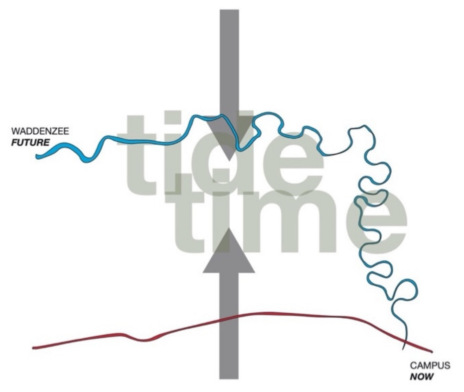
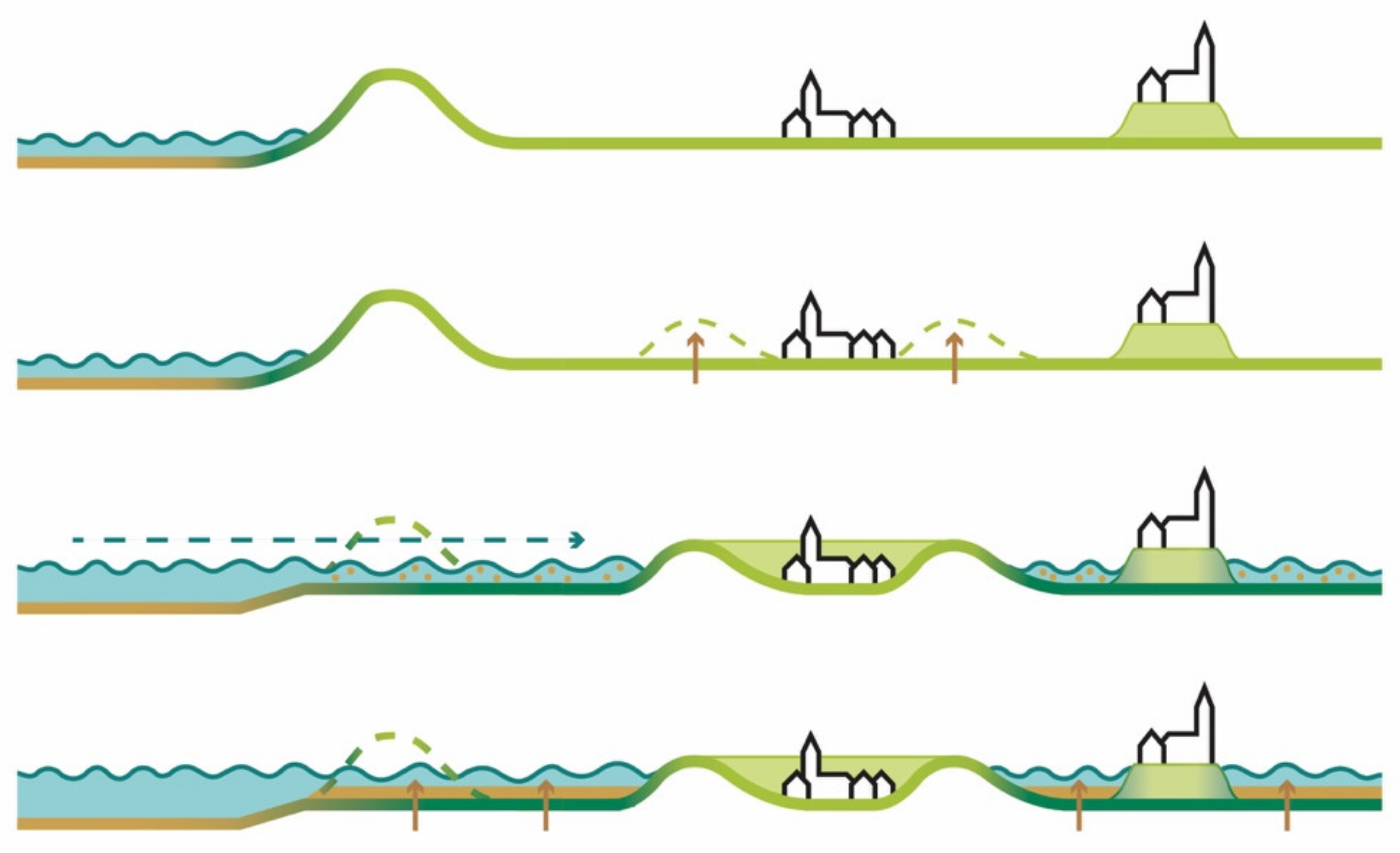
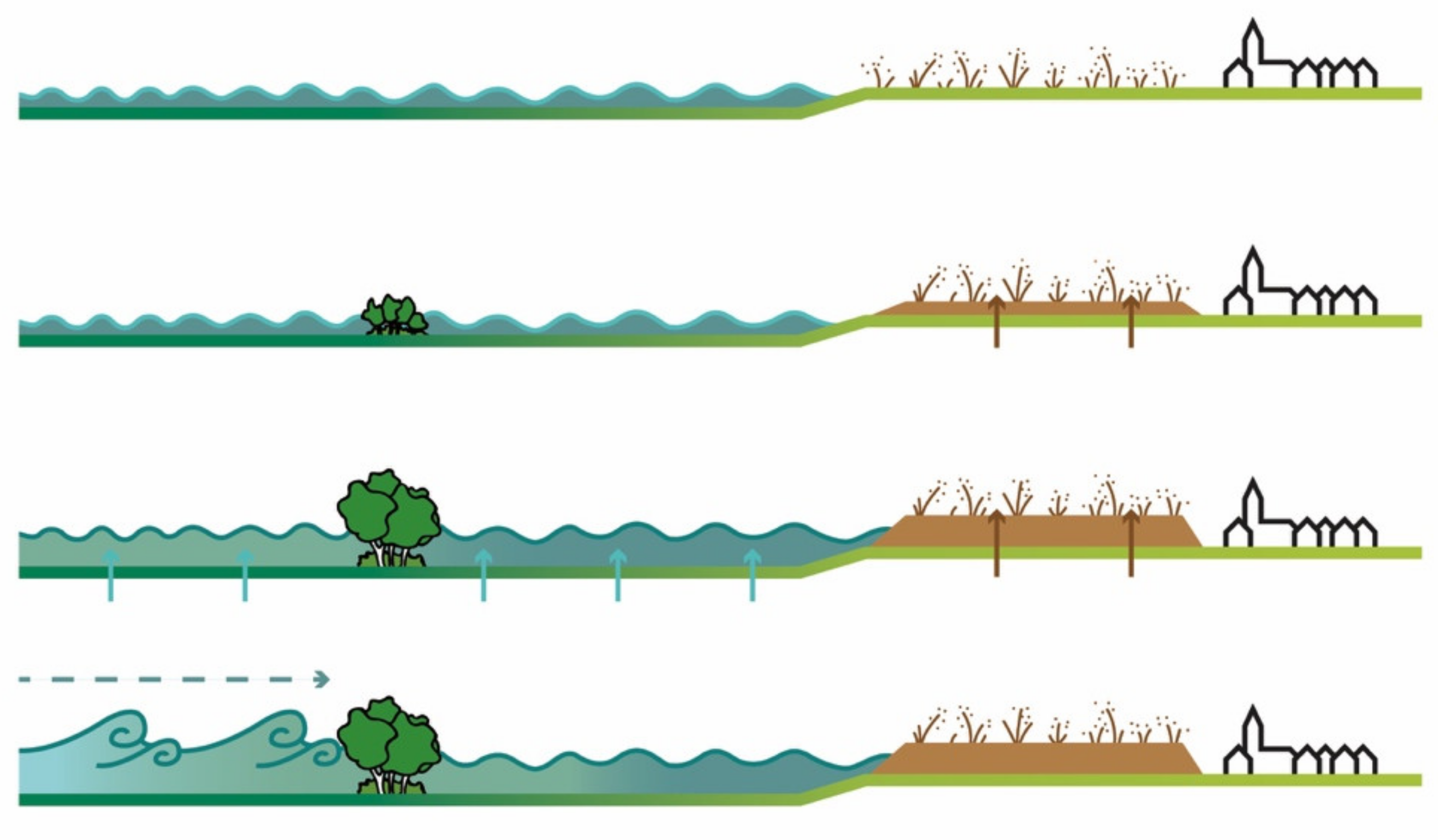
4.5. A staged Future

Once the long view and its implications are understood, decisions can be made about the implementation and working towards that desired future. This is an adaptive process, which can be adjusted along the way, depending new insights, changing climatic circumstances, and other unforeseeable developments. Backcasting [48,49] from 2121 to 2021 a set of bifurcation points [59,60,61,62], essential choices to change path can be estimated. These points are linked to the principle of climate changing in sudden steps [63,64], which non-linearly cause a new set of parameters that suddenly form novel conditions. These momentums are seen as the crucial moments in time when adjusted policies must have been implemented. The proposed time steps are dividing the 100-year period in evenly distributed periods. Because it cannot be exactly predicted when step changes will take place, these periods are estimates about future climate change which need to be carefully monitored to accurately pinpoint the moments of change more precisely. This monitoring will need to happen while planning for the future, from the present day leading to a continuous adjustment during this 100-year period. This is a process of slowly re-dynamizing the landscape that will not occur overnight, but rather is appearing as a slow process of modest emergence and change. The increasingly resilient landscape allows the current inhabitants to stay. Four stages of development capture this tranquil transformation (Figure 15), from a closed and protected static landscape to a rich, dynamic, and diverse riverine land.
In the first stage (2031), a little gap opens the Hinterland for seawater in small amounts. The Wadden dike is opened at Wierhuizen to let the water enter the land behind the dike in a controlled way. Directly behind the dike, current low-lying agricultural land will be inundated, and sediment will begin raising the land. In this first phase, saline water will be reintroduced in the northern parts of the former meander relics of the Reitdiep stream. The first locations for peat growth are established and experimental forms of saline agri- and aquaculture are undertaken. Larger nature reserves are created along the northern coast.
The second stage, until 2061, shows a continuation of the early experiments in a larger area. The north-eastern agricultural grounds are opened to the influence of sea water and are filling up with sediment, again raising the ground level of the landscape. The entire peat-zone around the northern edge of the city is established, and the process of reed-growing and peat forming is well under way. The historic wierden in the north part of the landscape will be reinforced, and new wierden will be constructed to create places for future safe living. The transition in the food system is almost complete, and the majority of the farmers have embraced new food production methods, inclusive of saline crops, seafood-farming, algae plantations, and mussel and oyster fields. The rewilding of the natural environment is well under way with (re)introduction of (new) species, enriching the food-web of the salt marshes and brackish grounds, and starts to self-establish.
In stage three, until 2091, the connection between the sea and the city is completed. The sedimentation and rising of the land continues, and the area around Bedum is now opened to the influence of the sea, allowing for the landscape to be raised. Peat is fully grown, and raised peat bogs are strong enough to form a defensive line protecting the city. Agriculture is flourishing and fully adapted to the new conditions. Nature is strong and large enough to self-organize its emergent succession processes. Its growth and decline form a natural equilibrium, protecting the coast in a systemic way.
The final stage (2121) shows the transformed northern landscape, where additional connections between sea and land are created, forming a saline-brackish landscape, in which all subsided parts of the landscape are reversed and “upsided”. The peat is fully grown and protecting the city. New and old wierden form crash-proof bastions in the landscape, able to withstand extreme water levels, storms, and inundation.
In parallel, a multiplicity of processes of growth and emergence strengthen the reliance and increase the adaptive capacity of all landscape and urban systems.
The process of land rising (Figure 16) takes place over a longer period of permanent seawater supplying sediment to the land. Over time, the process of terraforming will gain more space and reach existing settlements. Though it increases the safety from flooding, it also means that the sea itself comes closer to these settlements, which urges protection in the form of new bastions or inversed wierden systems.
The process of peat formation (Figure 17) is a slow development, which requires a long-term perspective. Therefore, it should start quickly, and be continued over a long period. First, the reed plants will start growing. After dying, these plants will rot to form peat. Slowly, additional layers of rotten plants will form higher levels of peat, until a raised bog emerges. Once this occurs, the peat landscape will have protective power for the inhabited urban areas. In the river system, a river forest will grow to minimize the influence of highwater levels in the streams and reduce the power of storm surges.
The food system increasingly comes under the influence of saline conditions. This means the traditional agricultural crops, such as potatoes, sugar beet, or grassland, will over time be replaced by saline crops, fish in farms or natural environments, free range livestock, and controlled aquaculture (Figure 18).

5. Discussion

Long term change is something that for ordinary people, scientists, and politicians is hard to imagine. Policy making is generally only interested in the short-term, immediate decision making, and tangible implementations of convictions. In this context, uncertainty is experienced, an enemy of the immediacy of policy processes. In the long term, this raises the question, however, if added up vulnerabilities lead to complexities that in the end cannot be understood nor solved, certainly not in the way short term and sectoral policies have evolved to operate.
This poses a dilemma: Proposing the long view is contradicting fast and firm decisions, that are visible for the public, tick boxes, and gain electoral support. However, the stacked vulnerabilities cannot be treated with these immediate responses, that only solve the visible problems. Deeper causes that are rooted in the complexities of interrelated problems, cannot be seen without taking the perspective of the longer term, and relate different functional aspects to each other. This dilemma shall be overcome by a allowing for backcasting processes and thinking to occur and be adopted by the regional stakeholders and residents themselves. The government is in the position to create the space for these processes, moreover, to stimulate and support the process to take place. The local communities have the obligation to then take over and organize the process of backcasting themselves, resulting in inspiring future perspectives that, on their turn, need to be embraced by the higher levels of government, responsible for implementation and funding of the outcomes.
The problems humanity faces, food insecurity and pandemics, ecological regression, and climate change, are all results of stacked solutions for immediate problems, which could not prevent the rotting process of bigger, invisible problems. The only way to counteract these slowly progressing problems that suddenly and unexpectedly appear above ground is to come loose of the daily routine of responding to the next urgency.
The long-term therefore must be, but also the belief in technological solutions (not meaning innovations or products), but the technical approach to solving problems has brought us further away from the resilient powers of natural balances. Every technical solution for a climate problem, species loss, or food provision has undermined the resilience of the system. Trusting the self-regulatory powers of these systems brings us to a future in which long-term livability on the earth can be sustained.
The combination of natural solutions with a long-term perspective is thinking against the Zeitgeist, the current way societies are tackling future problems, and responding to the immediacies of our time. An instant response seems to be required because otherwise one’s reliability is brought in discredit. Fear rules over courage, and the bureaucratic processes are supportive of keeping up appearances so no-one gets in trouble. Slowly, the cumulative decisions are bringing us to the edge of disaster. No-one seems to be capable of turn tides on climate change, biodiversity loss, or food-borne illnesses. Future life is dependent on counterintuitive courage showing the longer term and a holistic approach in which the forces of nature guide man to continue to inhabit this planet. The presented research in this article is a unique approach overcoming the current habits and standardized ways of working, but can be linked to initiatives of the UNEP, announcing the decade of regeneration [80] or the attention given to the concepts of Nature-Based Solutions [81] and Building with Nature [40].
Many cities and countries around the world face the same problem and are reluctant to tackle real action. The way forward is simple: Be idealistic, realistic, and fantastic. Idealistically start with formulating the imaginable on a timeframe of 50–100 years, the world how it is fantasized as a place for longevity. Realistically, exploring the possibilities on a 20-year time horizon, in which the future objectives are designed for a concrete area and society. Thirdly, fantastically design and build the future, with a 5-year scope, in a way it is attractive, healthy, safe, and enjoyable for urban inhabitants. In between the idealistic and the realistic, take the time to contemplate which of the ideals are essential to being realized for the benefit of sustaining life. Additionally, in between realistic and fantastic, take time again for contemplation of how to relate the different explorations to each other and how symbiosis can be achieved. Then plan and design holistically for the most beautiful environment possible.

6. Conclusions

Integration of problems and looking at them form a long-term perspective is needed to overcome staring in the headlights, be blinded to the real problems, and take only short-term decisions. The plan presented in this article has shown that a long-term perspective can leapfrog stacked vulnerabilities to reach a prosperous future. Re-dynamizing the landscape offers multiple solutions by implementing only one intervention. The re-establishment of the contact between land and sea provides the landscape with greater safety, better nature, and the amounts of water needed to grow the food demanded by the population. This could create a land that is independent from external flows and sources. Not because it doesn’t want to attach to others, but only to be prudent and caring for the environment. However, offering an example how other regions can make the transition from the shortsightedness to a visionary future.
Understanding the landscape as the point of departure for urban and landscape transformation is essential to find a way out of the current monetary viewpoint and the economization of land-uses. When the landscape, its ecological, soil-, and water-systems are preconceived, the future developments will follow, because the basic framework and the natural processes will naturally guide what is possible. You do not farm where it is too wet. You do not live where floods come. Where nature provides fertility, you can farm, where the landscape rises, there is land where you can live. This transformation is not an easy process, but will, for many, be a painful change with loss of land and jobs, or moving house.
One of the limitations of the study is that the salinification of intruding seawater and seepage are used as the thriving factor for transforming agriculture to more saline cropping and products. However, salinization of the soil due to the rise of temperature is not taken into account.
The conclusion of this research is that not only for the benefit of ecology, health, and safety a landscape driven approach is preferred, but that it also gives a new economic perspective for a society in decline. The city of Groningen is not shrinking, however, large parts of the rural surroundings are. The spatial plan presented in this article estimates 20% of the current productive landscape is needed to grow all the food required for the future population in the study area. This implies that the rest of the landscape can be transformed and regenerated as wetland and ecological reserves. This ensures it may be beneficial to transgress the current status of stand still. Not moving forward is in essence moving backward. The resilience cycle is already showing that growth and decline will lead to regenerated and higher levels of resilience and strength of the system [82]. As humanity, we need to continue applying this wisdom.

Author Contributions

Writing—original draft preparation, R.R., writing—review and editing, N.T., visualization, M.H. All authors have read and agreed to the published version of the manuscript.

Funding

This research received no external funding.

Institutional Review Board Statement

Not applicable.

Informed Consent Statement

Not applicable.

Conflicts of Interest

The authors declare no conflict of interest.

References

  1. IPCC. Climate Change 2014: Synthesis Report. Contribution of Working Groups I, II and III to the Fifth Assessment Report of the Intergovernmental Panel on Climate Change; Core Writing Team, Pachauri, R.K., Meyer, L.A., Eds.; IPCC: Geneva, Switzerland, 2014; p. 151. [Google Scholar]
  2. Crutzen, P.J. Geology of mankind. Nature 2002, 415, 23. [Google Scholar] [CrossRef]
  3. IPCC. IPCC Special Report on Climate Change, Desertification, Land Degradation, Sustainable Land Management, Food Security, and Greenhouse Gas Fluxes in Terrestrial Ecosystems. Summary for Policymakers; Approved Draft; IPCC: Geneva, Switzerland, 2019; Available online: https://www.ipcc.ch/report/srccl/ (accessed on 10 August 2020).
  4. IPBES. Summary for Policymakers of the Global Assessment Report on Biodiversity and Ecosystem Services of the Intergovernmental Science-Policy Platform on Biodiversity and Ecosystem Services; Díaz, J.S., Settele, E.S., Brondizio, E.S., Ngo, H.T.M., Guèze, J., Agard, A., Arneth, P., Balvanera, K.A., Brauman, S.H.M., et al., Eds.; IPBES-Secretariat: Bonn, Germany, 2019. [Google Scholar]
  5. Orr Roberts, W. Climate change and the quality of life for the earth’s new millions. Proc. Am. Philos. Soc. 1976, 120, 230–232. Available online: https://www.jstor.org/stable/986562 (accessed on 21 December 2020).
  6. Mupedziswa, R.; Kubanga, K.P. Climate change, urban settlements and quality of life: The case of the Southern African Development Community region. Dev. S. Afr. 2016, 34, 196–209. [Google Scholar] [CrossRef]
  7. Liang, L.; Deng, X.; Wang, P.; Wang, Z.; Wang, L. Assessment of the impact of climate change on cities livability in China. Sci. Total. Environ. 2020, 726, 138339. [Google Scholar] [CrossRef] [PubMed]
  8. Lindsey, R. Climate Change: Global Sea Level. Climate.gov. 2018. Available online: https://www.climate.gov/news-features/understanding-climate/climate-change-global-sea-level (accessed on 27 July 2020).
  9. Haasnoot, M.; Bouwer, L.; Diermanse, F.; Kwadijk, J.; Van der Spek, A.; Oude Essink, G.; Delsman, J.; Weiler, O.; Mens, M.; Ter Maat, J.; et al. Mogelijke Gevolgen van Versnelde Zeespiegelstijging voor het Deltaprogramma. Een Verkenning. Deltares Rapport 11202230-005-0002; Deltares: Delft, The Netherlands, 2018. [Google Scholar]
  10. Rockström, J.; Steffen, W.; Noone, K.; Persson, Å.; Chapin, F.S.; Lambin, E.F.; Lenton, T.M.; Scheffer, M.; Folke, C.; Schellnhuber, H.J.; et al. A safe operating space for humanity. Nature 2009, 461, 472–475. [Google Scholar] [CrossRef] [PubMed]
  11. Schipper, E.L.F.; Burton, I. (Eds.) Adaptation to Climate Change; Earthscan: London, UK, 2009. [Google Scholar]
  12. Global Commission on Adaptation Adapt Now: A Global Call for Leadership on Climate Resilience; Global Center on Adaptation, Groningen/Rotterdam and World Resources Institute: Washington, DC, USA, 2019.
  13. Schubert, D. Cities and plans—The past defines the future. Plan. Perspect. 2019, 34, 3–23. [Google Scholar] [CrossRef]
  14. Molotch, H.; Freudenburg, W.; Paulsen, K. History repeats itself, but how? City character, urban tradition, and the accom-plishment of place. Am. Sociol. Rev. 2000, 65, 791–823. Available online: http://www.jstor.org/stable/2657514 (accessed on 21 December 2020). [CrossRef]
  15. Lindblom, C.E. The science of “muddling through”. Public Adm. Rev. 1959, 19, 79–88. [Google Scholar] [CrossRef]
  16. Roggema, R.; Genel Altinkaya, Ö.; Psarra, I. De Toukomst is Al Lang Begonnen; Hanze University of Applied Sciences Groningen: Groningen, The Netherlands, 2020. [Google Scholar]
  17. Roggema, R. Bypassing the obvious: Implementing cutting edge ideas for futuring urban landscapes. Urban Reg. Plan. 2021, 6, 1–14. [Google Scholar] [CrossRef]
  18. Merry, U. Coping with Uncertainty. Insights from the New Sciences of Chaos, Self-Organisation and Complexity; Praeger Publishers: Westport, CT, USA, 1995. [Google Scholar]
  19. Schwarz, P. The Art of the Long View. Planning for the Future in San Uncertain World; Bantam Doubleday Dell Publishing Group Inc.: New York, NY, USA, 1991. [Google Scholar]
  20. Davy, B. Plan it without a condom! Plan. Theory 2008, 7, 301–317. [Google Scholar] [CrossRef]
  21. Roggema, R. Adaptation to Climate Change: A Spatial Challenge; Springer: Dordrecht, The Netherlands, 2009. [Google Scholar]
  22. Wrigley, C. Principles and practices of a design-led approach to innovation. Int. J. Des. Creativity Innov. 2017, 5, 235–255. [Google Scholar] [CrossRef]
  23. Balz, V. Regional Design. Discretionary Approaches to Planning in The Netherlands. Ph.D. Thesis, Delft University of Technology, Delft, The Netherlands, 2019. [Google Scholar]
  24. Yan, W.; Roggema, R. Developing a design-led approach for the food-energy-water nexus in cities. Urban. Plan. 2019, 4, 123–138. [Google Scholar] [CrossRef] [Green Version]
  25. WWF. Living Planet Report 2020—Bending the Curve of Biodiversity Loss; Almond, R.E.A., Grooten, M., Petersen, T., Eds.; WWF: Gland, Switzerland, 2020. [Google Scholar]
  26. Provincie Groningen De Toestand van Natuur en Landschap in de Provincie Groningen, 2017 Achtergronddocuent. Available online: https://destaatvangroningen.nl/uploads/toestand-van-natuur-en-landschap-achtergronddocument.pdf (accessed on 15 June 2020).
  27. CBS; PBL; RIVM; WUR. Boerenlandvogels, 1915–2018. Centraal Bureau voor de Statistiek (CBS), Den Haag; PBL Planbureau voor de Leefomgeving, Den Haag; RIVM Rijksinstituut voor Volksge-zondheid en Milieu, Bilthoven; Wageningen University and Research: Wageningen, The Netherlands, 2020; Available online: www.clo.nl (accessed on 5 February 2020).
  28. Teunissen, W.L. Soldaat Indexen en Trends van een Aantal Weidevogelsoorten uit het Weidevogelmeetnet. Periode 1990–2004. SOVON-Informatie 2005/13; SOVON Vogelonderzoek Nederland: Beek-Ubbergen, The Netherlands, 2005. [Google Scholar]
  29. Statline. Available online: www.statline.cbs.nl (accessed on 23 December 2020).
  30. Van Well, E.; Rougoor, C. Landbouw en Klimaatverandering in Groningen; CLM-Report CLM-904; CLM: Culemborg, The Netherlands, 2016. [Google Scholar]
  31. Ministerie van LNV Europese Landbouw—Beleid. Toelichting Op De Betalingen In Het Kader Van Het Gemeenschappelijk Landbouwbeleid in Het Boekjaar 2019; Ministerie van LNV: Den Haag, The Netherlands, 2019. [Google Scholar]
  32. Rosegrant, M.W.; Cline, S.A. Global food security: Challenges and policies. Science 2003, 302, 1917–1919. [Google Scholar] [CrossRef] [Green Version]
  33. World Health Organization. Food Safety Risk Analysis: A Guide for National Food Safety Authorities; WHO; FAO: Rome, Italy, 2006. [Google Scholar]
  34. Van Staveren, G.; Velstra, J. Verzilting van Landbouwgronden in Noord-Nederland in het Perspectief van de Effecten van Klimaatverandering; Onderzoeksprogramma Klimaat voor Ruimte/Climate Changes Spatial Planning: Den Haag, The Netherlands, 2012. [Google Scholar]
  35. De Vries, S. Increasing Drought: A New Enemy for The Netherlands. Available online: https://www.the-low-countries.com/article/increasing-drought-a-new-enemy-for-the-netherlands (accessed on 20 August 2020).
  36. Van der Woud, A. Het Landschap de Mensen. Nederland 1850–1940; Prometeus: Amsterdam, The Netherlands, 2020. [Google Scholar]
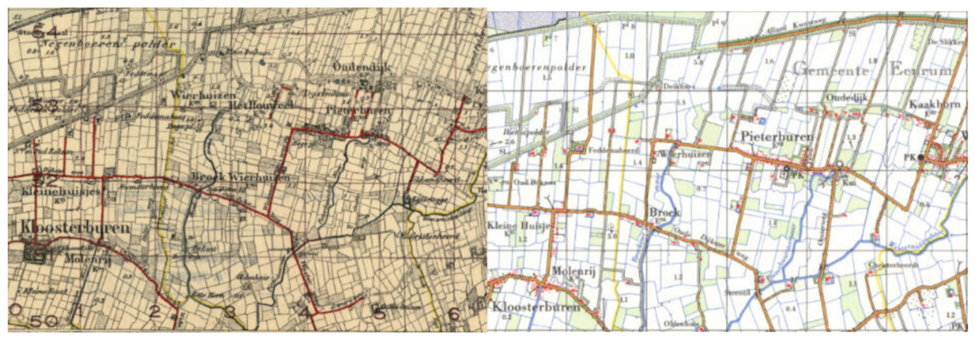
  37. Wiersma, J.; Nieuwhof, A. Het ontstaan van het terpen—En wierdenlandschap. In De Geschiedenis van Terpen—En Wierdenland: Een Verhaal in Ontwikkeling (Jaarverslagen van de Vereniging voor Terpenonderzoek); Nieuwhof, A., Nicolay, J., Wiersma, J., Eds.; Vereniging voor Terpenonderzoek: Groningen, The Netherlands, 2018; Volume 100, pp. 11–26. [Google Scholar]
  38. Ministerie van Verkeer en Waterstaat. Allerheiligenvloed 2006. Achtergrondverslag van de Stormvoed van 1 November 2006; RIKZ: Den Haag, The Netherlands, 2007. [Google Scholar]
  39. Delta Program Commissioner. Delta Program 2020. Continuing the Work on the Delta: Down to Earth, Alert, and Prepared; Ministry of Infrastructure and Water Management, Ministry of Agriculture, Nature, and Food Quality Ministry of the Interior and Kingdom Relations: Den Haag, The Netherlands, 2019. [Google Scholar]
  40. Van Eekelen, E.; Bouw, M. (Eds.) Building with Nature. Creating, Implementing and Upscaling Nature-Based Solutions; Nai010 Publishers: Rotterdam, The Netherlands, 2020. [Google Scholar]
  41. Kabat, P.; Fresco, L.O.; Stive, M.J.F.; Veerman, C.P.; Van Alphen, J.S.L.J.; Parmet, B.W.A.H.; Hazeleger, W.; Katsman, C.A. Dutch coasts in transition. Nat. Geosci. 2009, 2, 450–452. [Google Scholar] [CrossRef]
  42. Fry, T. Design Futuring; University of New South Wales Press: Sydney, Australia, 2009; pp. 71–77. [Google Scholar]
  43. Cornish, E. Futuring: The Exploration of the Future; World Future Society: Chicago IL, USA, 2004. [Google Scholar]
  44. Shipley, R.; Newkirk, R. Vision and visioning in planning: What do these terms really mean? Environ. Plan. B Plan. Des. 1999, 26, 573–591. [Google Scholar] [CrossRef]
  45. Gaffikin, F.; Sterrett, K. New visions for old cities: The role of visioning in planning. Plan. Theory Pract. 2006, 7, 159–178. [Google Scholar] [CrossRef]
  46. Roggema, R. Adaptation to climate change: Does spatial planning help? Swarm planning does! WIT Trans. Ecol. Environ. 2009, 127, 161–172. [Google Scholar]
  47. Gladwell, M. The Tipping Point: How Little Things Can Make a Big Difference; Little, Brown and Company: New York, NY, USA, 2000. [Google Scholar]
  48. Holmberg, J.; Robèrt, K.H. Backcasting—A framework for strategic planning. Int. J. Sustain. Dev. World Ecol. 2000, 7, 291–308. [Google Scholar] [CrossRef]
  49. Quist, J. Backcasting for a Sustainable Future: The Impact After 10 Years; Eburon Uitgeverij BV: Utrecht, The Netherlands, 2007. [Google Scholar]
  50. Van der Heijden, K. Scenarios: The Art of Strategic Conversation; John Wiley: New York, NY, USA, 1997. [Google Scholar]
  51. Shoemaker, P.J.H. Scenario Planning: A tool for strategic thinking. Sloan Manag. Rev. 1995, 37, 25–40. [Google Scholar]
  52. Ramirez, R.; Wilkinson, A. Strategic Reframing: The Oxford Scenario Planning Approach; Oxford University Press: Oxford, UK, 2016. [Google Scholar]
  53. De Jong, T.M. Kleine Methodologie voor Ontwerpend Onderzoek; BOOM Uitgevers: Amsterdam, The Netherlands, 1992. [Google Scholar]
  54. Hauberg, J. Research by design—A research strategy. Rev. Lusófona Arquit. Educ./Archit. Educ. J. 2011, 5, 46–56. [Google Scholar]
  55. Milburn, L.-A.S.; Brown, R.D. The relationship between research and design in landscape architecture. Landsc. Urban. Plan. 2003, 64, 47–66. [Google Scholar] [CrossRef] [Green Version]
  56. Roggema, R. Research by design: Proposition for a methodological approach. Urban. Sci. 2016, 1, 2. [Google Scholar] [CrossRef]
  57. Rosemann, J. The conditions of research by design in practice. In Research by Design: International Conference Faculty of Architecture Delft University of Technology in Co-Operation with the EAAE/AEEA November 1–3 2000: Proceedings A; Van Ouwerkerk, M., Rosemann, J., Eds.; Delft University Press: Delft, The Netherlands, 2001; pp. 63–68. [Google Scholar]
  58. Swann, C. Action research and the practice of design. Des. Issues 2002, 18, 49–61. [Google Scholar] [CrossRef]
  59. Wilson, A. Catastrophe Theory and Bifurcation (Routledge Revivals): Applications to Urban and Regional Systems; Routledge: London, UK, 2012. [Google Scholar]
  60. Adaptive water management: Integrated water management on the edge of chaos. Water Sci. Technol. 1995, 32, 7–13. [CrossRef]
  61. Roggema, R. Swarm planning: A new design paradigm dealing with long term problems associated with turbulence. In Business Planning for Turbulent Times, New Methods for Applying Scenarios; Ramirez, R., Selsky, J.W., Van der Heijden, K., Eds.; Earthscan: Abingdon, UK, 2008; pp. 103–129. [Google Scholar]
  62. Timmermans, W.; Ónega López, F.; Roggema, R. Complexity theory, spatial planning and adaptation to climate change. In Swarming Landscapes: The Art of Designing for Climate Adaptation; Roggema, R., Ed.; Springer: Dordrecht, The Netherlands, 2012; pp. 43–65. [Google Scholar]
  63. Jones, R. Detecting and attributing nonlinear anthropogenic regional warming in southeastern Australia. J. Geophys. Res. Space Phys. 2012, 117, 4. [Google Scholar] [CrossRef]
  64. Jones, R.; Ricketts, J.H. Reconciling the signal and noise of atmospheric warming on decadal timescales. Earth Syst. Dyn. 2017, 8, 177–210. [Google Scholar] [CrossRef] [Green Version]
  65. Condon, P.M. Design Charrettes for Sustainable Communities; Island Press: Washington, DC, USA, 2008. [Google Scholar]
  66. Lennertz, B.; Lutzenhiser, A. The Charrette Handbook. The Essential Guide for Accelerated Collaborative Community Planning; The American Planning Association: Chicago, IL, USA, 2006. [Google Scholar]
  67. Roggema, R.; Martin, J.; Horne, R. Sharing the climate adaptive dream: The benefits of the charrette approach. In Proceedings of the ANZRSAI Conference, Canberra, Australia, 6–9 December 2011; Dalziel, P., Ed.; AERU Research Unit: Canterbury, New Zealand, 2011. [Google Scholar]
  68. Roggema, R. (Ed.) The Design Charrette: Ways to Envision Sustainable Futures; Springer: London, UK; Dordrecht, The Netherlands, 2013. [Google Scholar]
  69. Cross, N. From a design science to a design discipline: Understanding designerly ways of knowing and thinking. In Design Research Now; Michel, R., Ed.; Birkhäuser: Basel, Switzerland, 2007; pp. 41–54. [Google Scholar] [CrossRef]
  70. Hocking, V.T. Designerly ways of knowing: What does design have to offer. In Tackling Wicked Problems Through the Transdisciplinary Imagination; Brown, V.A., Harris, J.A., Russell, J.Y., Eds.; Earthscan: Abingdon, UK, 2010; pp. 242–250. [Google Scholar]
  71. Sala, E. The Nature of Nature. Why We Need the Wild; National Geographic Partners, LLC: Washington, DC, USA, 2020. [Google Scholar]
  72. Santema, P.A. Voorraad Water Raakt op en er is Geen Alternatief. Leeuwarder Courant. 30 September 2020. Available online: https://www.lc.nl/friesland/Directeur-Wetsus-Voorraad-water-raakt-op-en-er-is-geen-alternatief-26062103.html?harvest_referrer=https%3A%2F%2Fwww.google.com%2F (accessed on 15 November 2020).
  73. Tree, I. Wilding, the Return of Nature to a British Farm; Picador: London, UK, 2018. [Google Scholar]
  74. Aan de Burgh, M. Zo leuk is de Natuur Niet Maar We Móéten er Iets Mee; NRC: Amsterdam, The Netherlands, 2020. [Google Scholar]
  75. Alkemade, F. De Toekomst van Nederland, de Kunst van Richting te Veranderen; Uitgeverij THOTH: Bussum, The Netherlands, 2020. [Google Scholar]
  76. Roggema, R.; Verheijden, B.; Hollanders, M.; Tillotson, R.; Fakhr Edin Alsharani, L. Moeder Zernike, Embracing a Natural Future; Hanze University of Applied Sciences: Groningen, The Netherlands, 2021. [Google Scholar]
  77. Willett, W.; Rockström, J.; Loken, B.; Springmann, M.; Lang, T.; Vermeulen, S.; Garnett, T.; Tilman, D.; Declerck, F.; Wood, A.; et al. Food in the Anthropocene: The EAT–Lancet Commission on healthy diets from sustainable food systems. Lancet 2019, 393, 447–492. [Google Scholar] [CrossRef]
  78. Van Oort, P.; Gou, F.; Stomph, T.-J.; Van Der Werf, W. Effects of strip width on yields in relay-strip intercropping: A simulation study. Eur. J. Agron. 2020, 112, 125936. [Google Scholar] [CrossRef]
  79. Glaze-Corcoran, S.; Hashemi, M.; Sadeghpour, A.; Jahanzad, E.; Keshavarz Afshar, R.; Liu, X.; Herbert, S.J. Understanding intercropping to improve agricultural resiliency and environmental sustainability. In Advances in Agronomy; Sparks, D.L., Ed.; Academic Press: Cambridge MA, USA, 2020; Volume 162, pp. 199–256. ISSN 0065-2113. ISBN 9780128207673. [Google Scholar] [CrossRef]
  80. UNEP. Decade on Restoration. 2020. Available online: https://www.decadeonrestoration.org (accessed on 24 January 2021).
  81. Cohen-Shacham, E.; Walters, G.; Janzen, C.; Maginnis, S. Nature-Based Solutions to Address Global Societal Challenges; IUCN: Gland, Switzerland, 2016. [Google Scholar]
  82. Gunderson, L.H.; Holling, C.S. Panarchy: Understanding Transformations in Human and Natural Systems; Island Press: Washington, DC, USA, 2002. [Google Scholar]
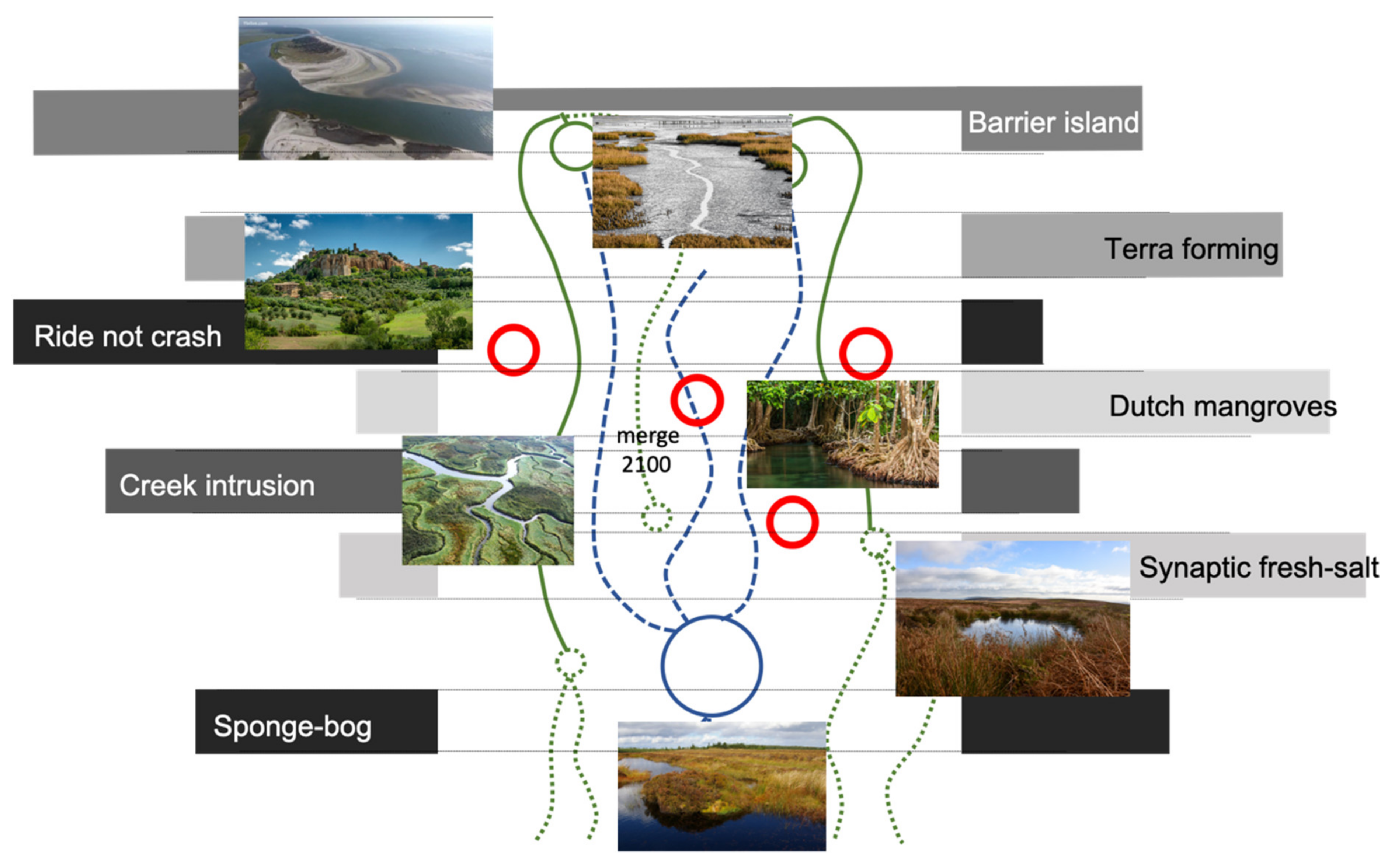
Figure 1. The northern Groningen landscape.
Land 10 00158 g001
Figure 2. Trends in bird populations open farmland in The Netherlands (in blue) (adapted from: [27]).
Land 10 00158 g002
Figure 3. Landscape change in the Marne area as result of land consolidation, situation in 1925 and 1975 (source: J.W. van Aalst, www.opentopo.nl).
Land 10 00158 g003
Figure 4. The methodology used in the research.
Land 10 00158 g004
Figure 5. Evolving towards a dynamic natural future.
Land 10 00158 g005
Figure 6. Balance between tide and time.
Land 10 00158 g006
Figure 7. Crucial transformative steps in landscape genesis of the northern Groningen landscape.
Land 10 00158 g007
Figure 8. Landscape genesis from 500 BC until 2000 AC.
Land 10 00158 g008
Figure 9. From separated fresh and saltwater systems towards joint and merging systems.
Land 10 00158 g009
Figure 10. Subsequent lines of protection projected in the northern landscape.
Land 10 00158 g010
Figure 11. Landscape design.
Land 10 00158 g011
Figure 12. Interplay of ecological landscapes: Tidal flats, salt marshes, wetlands, river forests, brackish creeks, and meadows.
Land 10 00158 g012
Figure 13. 2/3 of the area transformed into saline and brackish growing conditions bring a new agricultural perspective.
Land 10 00158 g013
Figure 14. The adjusted water system.
Land 10 00158 g014
Figure 15. Subsequent stages of landscape forming, 2031–2061–2091–2121.
Land 10 00158 g015
Figure 16. Raising the landscape.
Land 10 00158 g016
Figure 17. Peat formation.
Land 10 00158 g017
Figure 18. Salinification of the food system.
Land 10 00158 g018
Table 1. Lines of protection forming the emergent landscape.
NamePrinciple
Barrier islandNatural sea dynamics forming a barrier as an island in front of the coast
Creek intrusionAllowing for saltwater to intrude inland and to expand land forming at sea
Terra formingAllowing the sea water in, but slowing it down on the way back at ebb tide
Dutch mangrovesForests alongside the creeks slowing down the intruding water
Ride not crashConstructed protections preventing the flooding of houses and villages in the landscape during occasional extreme flooding
Synaptic fresh-saltSynergies where salt and fresh water meet, and could form the basis for blue energy
Sponge-bogSponge operation of the peat landscape
Table 2. Required area (ha) to keep the same income for four traditional crops.
Farm TypeFarm Size (m2)Net Income (Euro/Year)Type of ProduceArea (m2) Required to Grow Mixed Farms in Order to Get Traditional Farm Income
Sugar beet200,00047,60030% sugar beet/ 20% seafood/ 50% saline crops13,878 (6.5%)
Potatoes200,000147,60030% potatoes/ 20% seafood/ 50% saline crop41,229 (20.5%)
Wheat200,00021,00030% wheat/ 20% seafood/ 50% saline crops6195 (3%)
Milk (cow)200,00022,00030% cow milk/ 20% seafood/ 50% saline crops6471 (3%)
Average 200,00059,55030% existing/20% seafood/50% saline crops16,943.25 (8%)
Table 3. Recalculated area for existing and saline produce needed to earn similar income.
Crop Existing Area Current Land Use (ha) New Nature (ha) Area for Existing Crop after Transition (30%)Area for Sea Food (20%)Area for Saline Crops (50%)
Potato 6875275012038592063
Sugar beet2475198018662248
Wheat75006750225150375
Milk cows99758978299200499
Grassland 99758978299200499
Carrots 1200480210150360
Maize 1860167455.837.291
Barley 2060185461.841.2103
Total (ha) 41,92033,444254017004238
In %100%80%6%4%10%
Publisher’s Note: MDPI stays neutral with regard to jurisdictional claims in published maps and institutional affiliations.

