
Proximate and Underlying Deforestation Causes in a Tropical Basin through Specialized Consultation and Spatial Logistic Regression Modeling

 , ,
, ,  , , and
Abstract
:1. Introduction
2. Materials and Methods
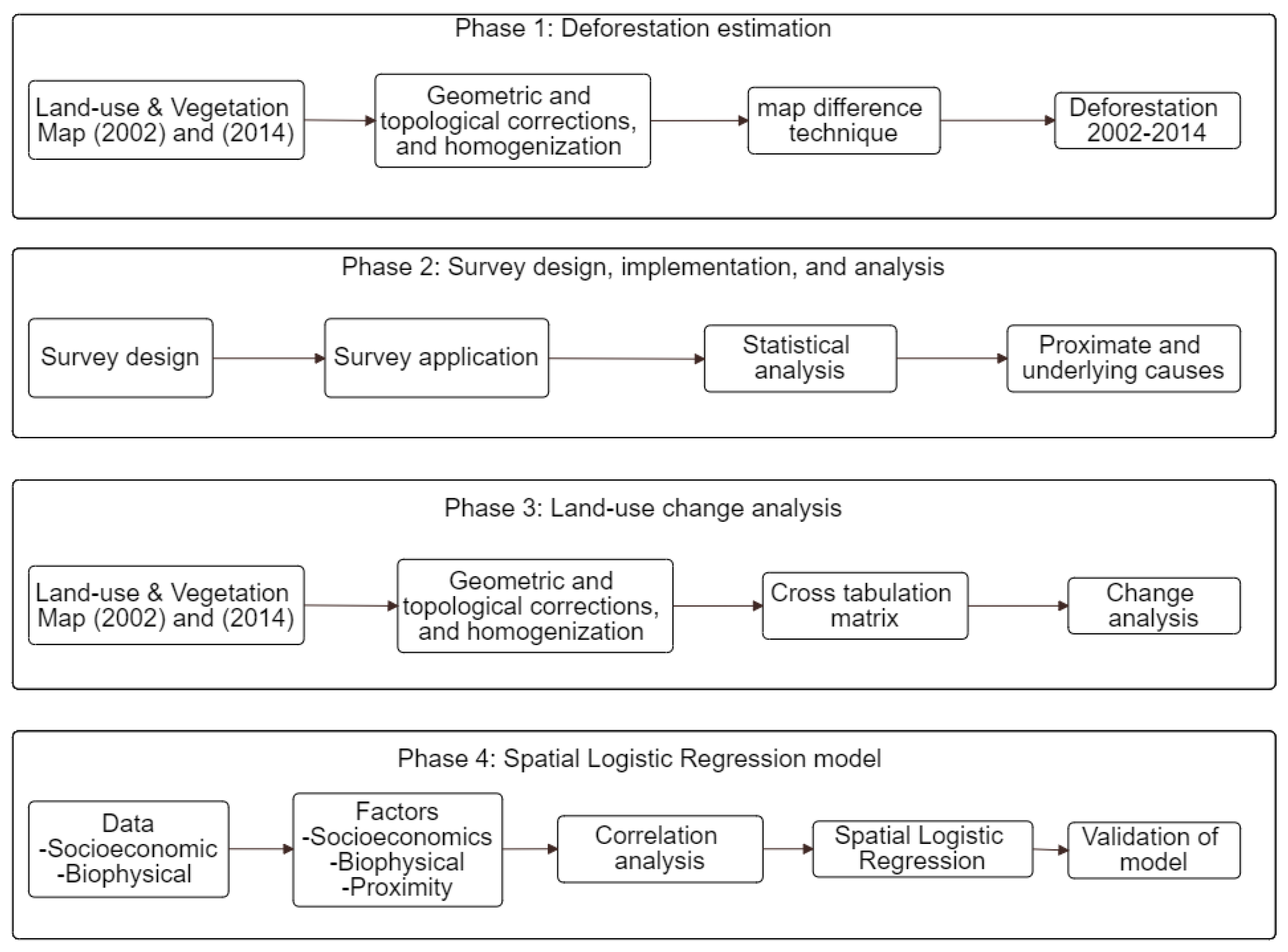
2.1. Methodology
2.1.1. Deforestation Estimation
2.1.2. Survey Design, Implementation, and Analysis
2.1.3. Land-Use Change Analysis
2.1.4. Determining the Factors of Deforestation
2.1.5. Spatial Logistic Regression (SLR) Model
2.1.6. Evaluation of the SLR Model
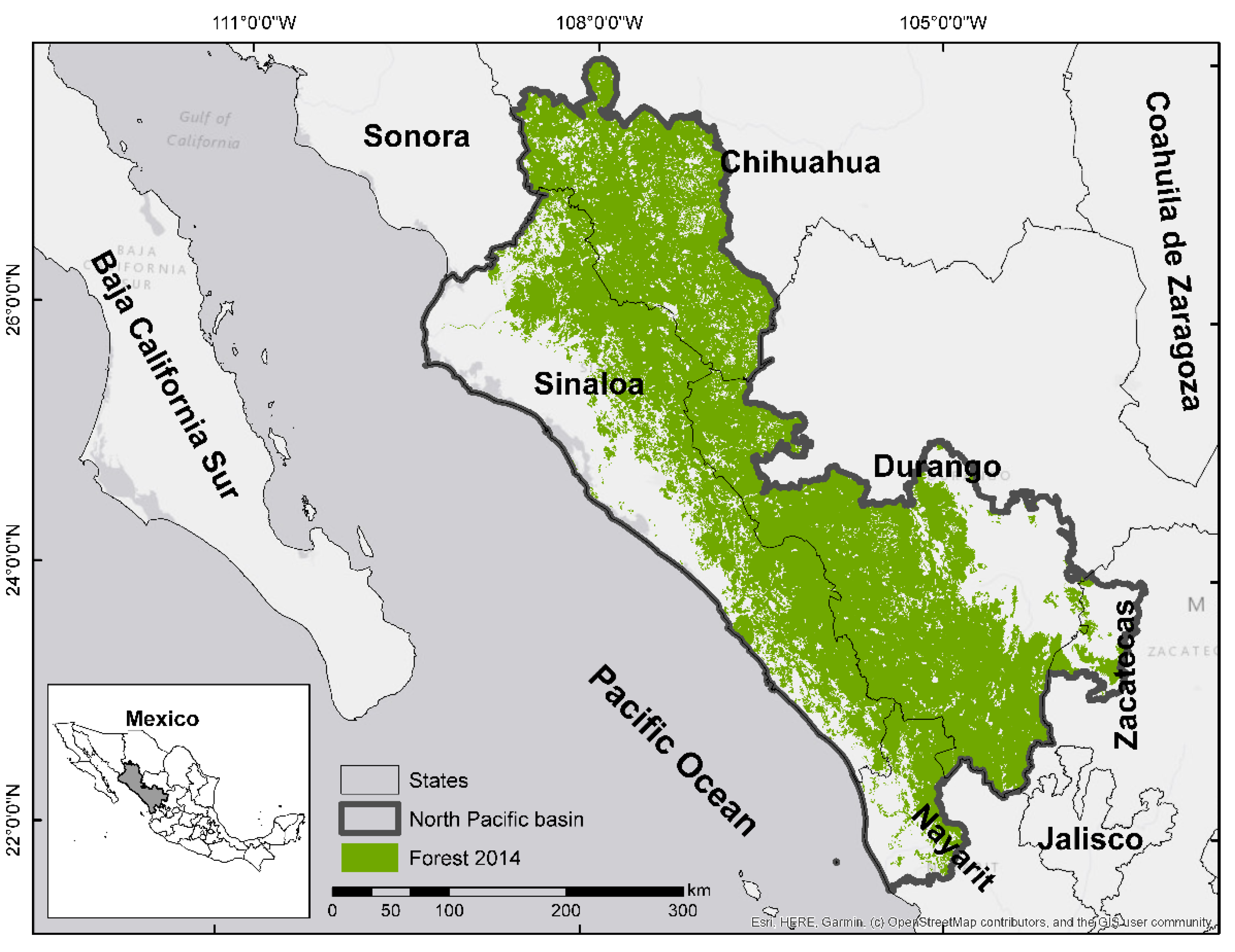
2.2. Study Area
2.3. Data
3. Results and Discussions
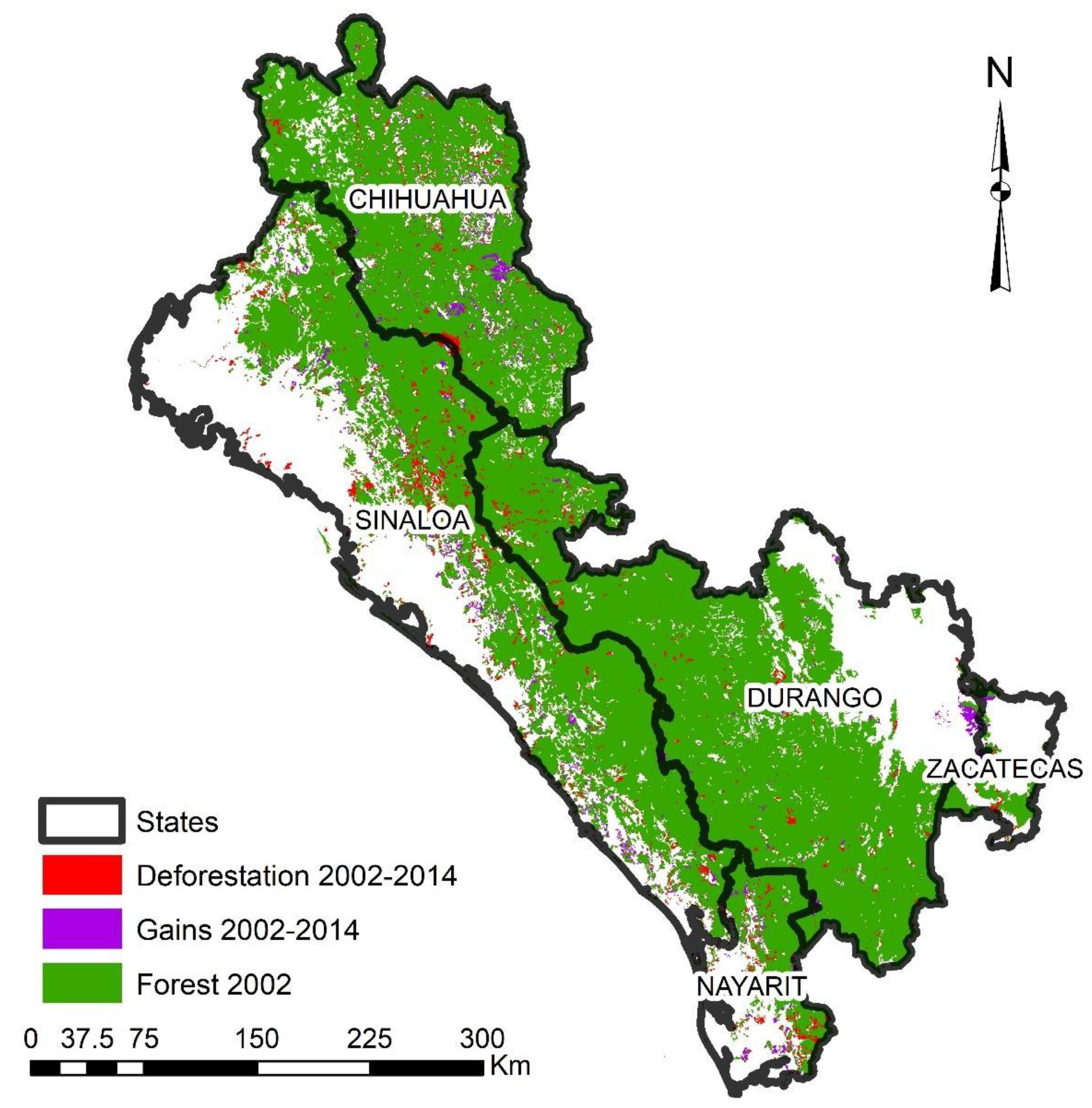
3.1. Deforestation Estimation
3.2. Survey Analysis
3.3. Land-Use Change Analysis
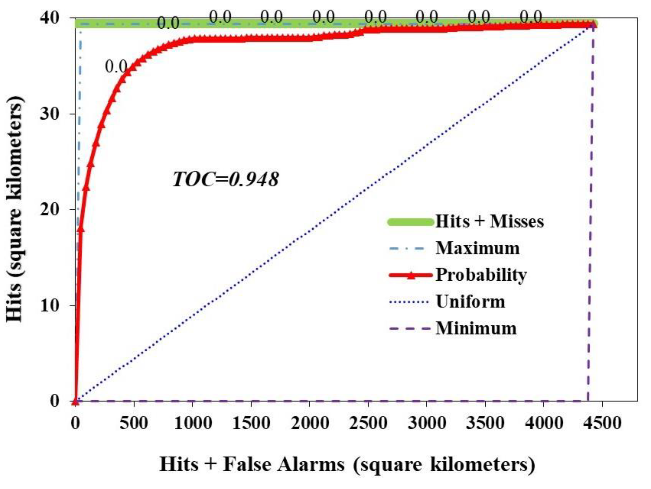
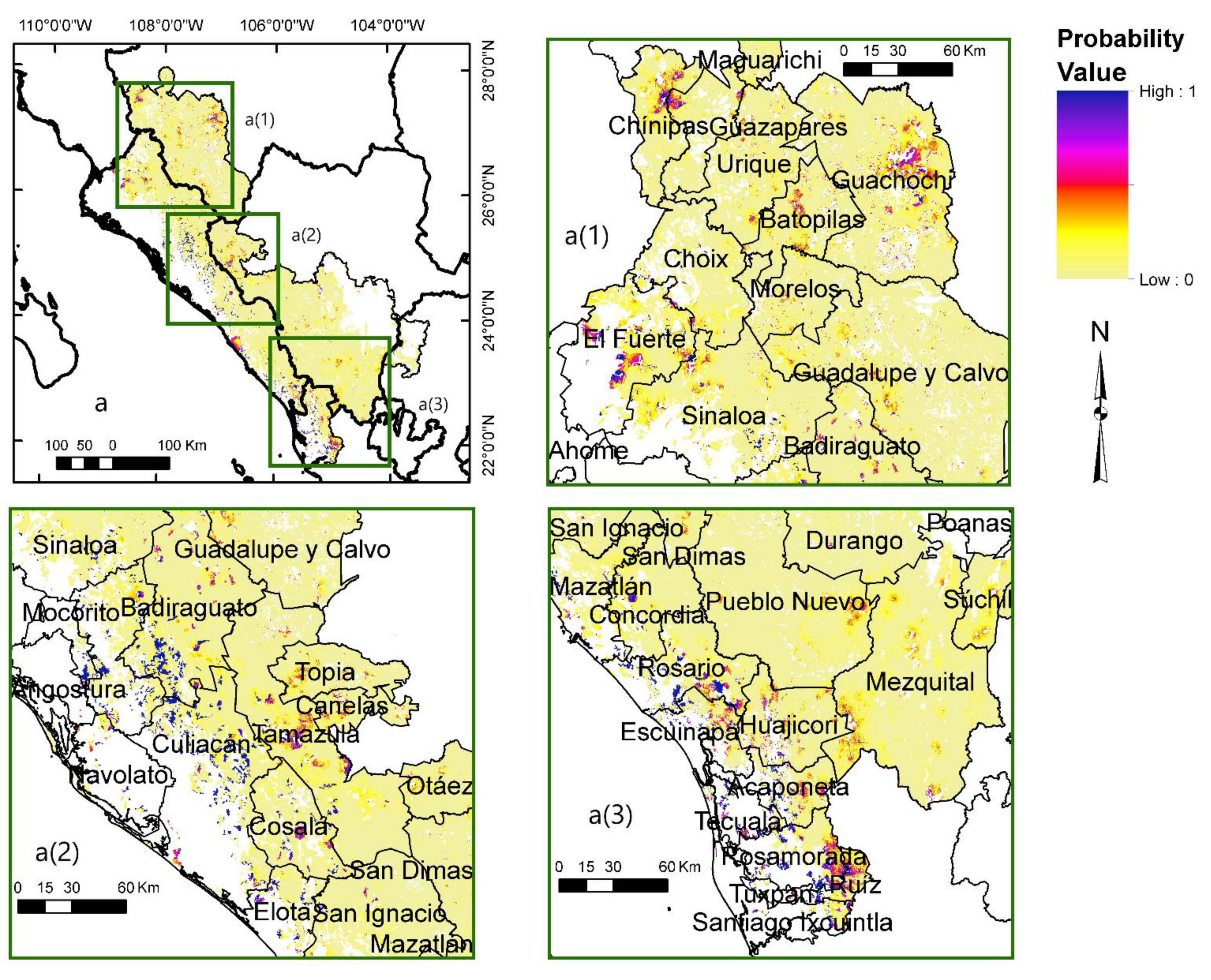
3.4. Adjustment and Evaluation of Spatial Logistic Regression (SLR) Model
4. Conclusions
Author Contributions
Funding
Institutional Review Board Statement
Informed Consent Statement
Data Availability Statement
Acknowledgments
Conflicts of Interest
References
- FAO. Global Forest Resources Assessment 2020 Key Findings 2020. Available online: http://www.fao.org/3/CA8753EN/CA8753EN.pdf (accessed on 23 June 2020).
- Cadman, T.; Maraseni, T.; Ma, H.O.; Lopez-Casero, F. Five years of REDD+ governance: The use of market mechanisms as a response to anthropogenic climate change. For. Policy Econ. 2017, 79, 8–16. [Google Scholar] [CrossRef]
- Houghton, R. Carbon emissions and the drivers of deforestation and forest degradation in the tropics. Curr. Opin. Environ. Sustain. 2012, 4, 597–603. [Google Scholar] [CrossRef]
- Nathan, I.; Pasgaard, M. Is REDD+ effective, efficient, and equitable? Learning from a REDD+ project in Northern Cambodia. Geoforum 2017, 83, 26–38. [Google Scholar] [CrossRef]
- FAO. Empowered Lives. Resilient Nations. The UN-REDD Programme is the United Nations Collaborative Initiative on Reducing Emissions from Deforestation and Forest Degradation (REDD+) in Developing Countries. 2013. Available online: http://www.fao.org/3/a-bc395e.pdf (accessed on 23 September 2020).
- Van Khuc, Q.; Tran, B.Q.; Meyfroidt, P.; Paschke, M.W. Drivers of deforestation and forest degradation in Vietnam: An exploratory analysis at the national level. For. Policy Econ. 2018, 90, 128–141. [Google Scholar] [CrossRef]
- Samndong, R.A.; Bush, G.; Vatn, A.; Chapman, M. Institutional analysis of causes of deforestation in REDD+ pilot sites in the Equateur province: Implication for REDD+ in the Democratic Republic of Congo. Land Use Policy 2018, 76, 664–674. [Google Scholar] [CrossRef]
- Aquino, A.; Guay, B. Implementing REDD+ in the Democratic Republic of Congo: An analysis of the emerging national REDD+ governance structure. For. Policy Econ. 2013, 36, 71–79. [Google Scholar] [CrossRef]
- Bax, V.; Francesconi, W.; Quintero, M. Spatial modeling of deforestation processes in the Central Peruvian Amazon. J. Nat. Conserv. 2016, 29, 79–88. [Google Scholar] [CrossRef]
- Moonen, P.C.; Verbist, B.; Schaepherders, J.; Meyi, M.B.; Van Rompaey, A.; Muys, B. Actor-based identification of deforestation drivers paves the road to effective REDD+ in DR Congo. Land Use Policy 2016, 58, 123–132. [Google Scholar] [CrossRef]
- Salvini, G.; Herold, M.; De Sy, V.; Kissinger, G.; Brockhaus, M.; Skutsch, M. How countries link REDD+ interventions to drivers in their readiness plans: Implications for monitoring systems. Environ. Res. Lett. 2014, 9, 074004. [Google Scholar] [CrossRef] [Green Version]
- Wang, X.; Zhang, Y.; Yan, E.; Huang, G.; Cao, C.; Ni, X. Deforestation area estimation in China based on Landsat data. In Proceedings of the 2014 IEEE Geoscience and Remote Sensing Symposium, Quebec City, QC, Canada, 13–18 July 2014; IEEE: Piscataway, NJ, USA, 2014; pp. 4254–4256. [Google Scholar]
- Geist, H.J.; Lambin, E.F. What Drives Tropical Deforestation? A Meta-Analysis of Proximate and Underlying Causes of Deforestation Based on Subnational Case Study Evidence; Louvain-la-Neuve (Belgium). 2001. Available online: http://www.pik-potsdam.de/~luedeke/lucc4.pdf (accessed on 27 August 2019).
- Geist, H.J.; Lambin, E.F. Proximate Causes and Underlying Driving Forces of Tropical DeforestationTropical forests are disappearing as the result of many pressures, both local and regional, acting in various combinations in different geographical locations. Bioscience 2002, 52, 143–150. [Google Scholar] [CrossRef]
- Hosonuma, N.; Herold, M.; De Sy, V.; De Fries, R.S.; Brockhaus, M.; Verchot, L.; Angelsen, A.; Romijn, E. An assessment of deforestation and forest degradation drivers in developing countries. Environ. Res. Lett. 2012, 7, 044009. [Google Scholar] [CrossRef]
- Lambin, E.F.; Geist, H.J.; Lepers, E. Dynamics Ofland-use Andland-Coverchange in TropicalL Regions. Annu. Rev. Environ. Resour. 2003, 28, 205–241. [Google Scholar] [CrossRef] [Green Version]
- Lambin, E.F.; Meyfroidt, P. Land use transitions: Socio-ecological feedback versus socio-economic change. Land Use Policy 2010, 27, 108–118. [Google Scholar] [CrossRef]
- Rudel, T.K.; De Fries, R.; Asner, G.P.; Laurance, W.F. Changing Drivers of Deforestation and New Opportunities for Conservation. Conserv. Biol. 2009, 23, 1396–1405. [Google Scholar] [CrossRef]
- Weatherley-Singh, J.; Gupta, A. Drivers of deforestation and REDD+ benefit-sharing: A meta-analysis of the (missing) link. Environ. Sci. Policy 2015, 54, 97–105. [Google Scholar] [CrossRef]
- Defourny, P.; Delhage, C.; Kibambe Lubamba, J.-P. Analyse Quantitative des Causes de la Deforestation et de la Degradation des Forets en Republique Democratique du Congo—UN-REDD Programme Collaborative Online Workspace. 2011. Available online: https://www.unredd.net/documents/un-redd-partner-countries-181/africa-335/democratic-republic-of-the-congo-189/studies-publications-and-other-resources-500/15896-analyse-quantitative-des-causes-de-la-deforestation-et-de-la-degradation-des-forets-en-republique-democratique-du-congo-rapport-final.html?path=un-redd-partner-countries-181/africa-335/democratic-republic-of-the-congo-189/studies-publications-and-other-resources-500 (accessed on 25 August 2020).
- Mecnt Etude sur les Moteurs de la Deforestation: Etape de Validation. 2012. Available online: https://wwfeu.awsassets.panda.org/downloads/_a6_etude_qualitative_moteurs_deforestation_degradation.pdf (accessed on 10 August 2020).
- MECNT. Etude Qualitative sur les Causes de la Déforestation et de la Dégradation des Forêts en République Démocratique du Congo. 2012. Available online: https://www.unredd.net/documents/un-redd-partner-countries-181/africa-335/democratic-republic-of-the-congo-189/15160-etude-qualitative-sur-les-causes-de-la-deforestation-et-de-la-degradation-des-forets-en-republique-democratique-du-congo.html?path=un-redd-partner-countries-181/africa-335/democratic-republic-of-the-congo-189 (accessed on 12 August 2020).
- Armenta, S.A.M.; Angulo, C.E.P.; Rocha, W.P.; Barraza, G.C.; Andrade, R.R.; Gonzalez, J.C.B. Determination and Analysis of Hot Spot Areas of Deforestation Using Remote Sensing and Geographic Information System Techniques. Case Study: State Sinaloa, México. Open J. For. 2016, 6, 295–304. [Google Scholar] [CrossRef] [Green Version]
- Angulo, C.E.P.; Aguado, M.I.; Mollicone, D. Identification and characterization of deforestation hot spots in Venezuela using MODIS satellite images. Acta Amaz. 2014, 44, 185–196. [Google Scholar] [CrossRef] [Green Version]
- Madalcho, A.B.; Mena, M.M.; Badeso, B.B. Causes and Impacts of Deforestation and Forest Degradation at Duguna Fango Woreda. Int. J. Nat. Resour. Ecol. Manag. 2020, 5, 14. [Google Scholar] [CrossRef]
- Twongyirwe, R.; Bithell, M.; Richards, K.S.; Rees, W. Do livelihood typologies influence local perceptions of forest cover change? Evidence from a tropical forested and non-forested rural landscape in western Uganda. J. Rural Stud. 2017, 50, 12–29. [Google Scholar] [CrossRef] [Green Version]
- Twongyirwe, R.; Bithell, M.; Richards, K.S. Revisiting the drivers of deforestation in the tropics: Insights from local and key informant perceptions in western Uganda. J. Rural Stud. 2018, 63, 105–119. [Google Scholar] [CrossRef] [Green Version]
- Ngwira, S.; Watanabe, T. An Analysis of the Causes of Deforestation in Malawi: A Case of Mwazisi. Land 2019, 8, 48. [Google Scholar] [CrossRef] [Green Version]
- Zeb, A.; Hamann, A.; Armstrong, G.W.; Acuna-Castellanos, D. Identifying local actors of deforestation and forest degradation in the Kalasha valleys of Pakistan. For. Policy Econ. 2019, 104, 56–64. [Google Scholar] [CrossRef]
- Etter, A.; McAlpine, C.; Pullar, D.; Possingham, H. Modelling the conversion of Colombian lowland ecosystems since 1940: Drivers, patterns and rates. J. Environ. Manag. 2006, 79, 74–87. [Google Scholar] [CrossRef]
- Serneels, S.; Lambin, E.F. Proximate causes of land-use change in Narok District, Kenya: A spatial statistical model. Agric. Ecosyst. Environ. 2001, 85, 65–81. [Google Scholar] [CrossRef] [Green Version]
- Wyman, M.S.; Stein, T.V. Modeling social and land-use/land-cover change data to assess drivers of smallholder deforestation in Belize. Appl. Geogr. 2010, 30, 329–342. [Google Scholar] [CrossRef]
- Mas, J. Modelling deforestation using GIS and artificial neural networks. Environ. Model. Softw. 2004, 19, 461–471. [Google Scholar] [CrossRef]
- Mayfield, H.; Smith, C.; Gallagher, M.; Hockings, M. Use of freely available datasets and machine learning methods in predicting deforestation. Environ. Model. Softw. 2017, 87, 17–28. [Google Scholar] [CrossRef] [Green Version]
- Manson, S.M.; Evans, T. Agent-based modeling of deforestation in southern Yucatan, Mexico, and reforestation in the Midwest United States. Proc. Natl. Acad. Sci. USA 2007, 104, 20678–20683. [Google Scholar] [CrossRef] [PubMed] [Green Version]
- Basse, R.M.; Omrani, H.; Charif, O.; Gerber, P.; Bódis, K. Land use changes modelling using advanced methods: Cellular automata and artificial neural networks. The spatial and explicit representation of land cover dynamics at the cross-border region scale. Appl. Geogr. 2014, 53, 160–171. [Google Scholar] [CrossRef]
- Behera, M.D.; Borate, S.N.; Panda, S.N.; Behera, P.R.; Roy, P.S. Modelling and analyzing the watershed dynamics using Cellular Automata (CA)–Markov model – A geo-information based approach. J. Earth Syst. Sci. 2012, 121, 1011–1024. [Google Scholar] [CrossRef] [Green Version]
- Berberoğlu, S.; Akın, A.; Clarke, K.C. Cellular automata modeling approaches to forecast urban growth for adana, Turkey: A comparative approach. Landsc. Urban Plan. 2016, 153, 11–27. [Google Scholar] [CrossRef]
- Jantz, C.A.; Goetz, S.J.; Donato, D.; Claggett, P. Designing and implementing a regional urban modeling system using the SLEUTH cellular urban model. Comput. Environ. Urban Syst. 2010, 34, 1–16. [Google Scholar] [CrossRef]
- López-Carr, D.; Davis, J.; Jankowska, M.M.; Grant, L.; López-Carr, A.C.; Clark, M. Space versus place in complex human–natural systems: Spatial and multi-level models of tropical land use and cover change (LUCC) in Guatemala. Ecol. Model. 2012, 229, 64–75. [Google Scholar] [CrossRef] [Green Version]
- Overmars, K.P.; Verburg, P.H. Multilevel modelling of land use from field to village level in the Philippines. Agric. Syst. 2006, 89, 435–456. [Google Scholar] [CrossRef]
- Austin, K.G.; Schwantes, A.M.; Gu, Y.; Kasibhatla, P.S. What causes deforestation in Indonesia? Environ. Res. Lett. 2018, 14, 024007. [Google Scholar] [CrossRef]
- Hidayat, T.A. Spatial Analysis of Causes of Deforestation in Indonesia. 2019. Available online: https://edepot.wur.nl/504239 (accessed on 20 December 2020).
- Alix-Garcia, J. A spatial analysis of common property deforestation. J. Environ. Econ. Manag. 2007, 53, 141–157. [Google Scholar] [CrossRef]
- Ellis, E.A.; Baerenklau, K.A.; Marcos-Martínez, R.; Chávez, E. Land use/land cover change dynamics and drivers in a low-grade marginal coffee growing region of Veracruz, Mexico. Agrofor. Syst. 2010, 80, 61–84. [Google Scholar] [CrossRef] [Green Version]
- Ellis, E.A.; Montero, J.A.R.; Gómez, I.U.H.; Porter-Bolland, L.; Ellis, P.W. Private property and Mennonites are major drivers of forest cover loss in central Yucatan Peninsula, Mexico. Land Use Policy 2017, 69, 474–484. [Google Scholar] [CrossRef]
- López-Barrera, F.; Manson, R.H.; Landgrave, R. Identifying deforestation attractors and patterns of fragmentation for seasonally dry tropical forest in central Veracruz, Mexico. Land Use Policy 2014, 41, 274–283. [Google Scholar] [CrossRef]
- Miranda-Aragón, L.; Treviño-Garza, E.J.; Jiménez-Pérez, J.; Aguirre-Calderón, O.A.; González-Tagle, M.A.; Pompa-García, M.; Aguirre-Salado, C.A.; Treviño-Garza, E. Modeling susceptibility to deforestation of remaining ecosystems in North Central Mexico with logistic regression. J. For. Res. 2012, 23, 345–354. [Google Scholar] [CrossRef]
- Morales-Barquero, L.; Borrego, A.; Skutsch, M.; Kleinn, C.; Healey, J.R. Identification and quantification of drivers of forest degradation in tropical dry forests: A case study in Western Mexico. Land Use Policy 2015, 49, 296–309. [Google Scholar] [CrossRef] [Green Version]
- Chowdhury, R.R. Landscape change in the Calakmul Biosphere Reserve, Mexico: Modeling the driving forces of smallholder deforestation in land parcels. Appl. Geogr. 2006, 26, 129–152. [Google Scholar] [CrossRef]
- Vaca, R.A.; Golicher, D.J.; Rodiles-Hernández, R.; Castillo-Santiago, M.Á.; Bejarano, M.; Navarrete-Gutiérrez, D.A. Drivers of deforestation in the basin of the Usumacinta River: Inference on process from pattern analysis using generalised additive models. PLoS ONE 2019, 14, e0222908. [Google Scholar] [CrossRef] [PubMed]
- Jaimes, N.B.P.; Sendra, J.B.; Delgado, M.G.; Plata, R.F. Exploring the driving forces behind deforestation in the state of Mexico (Mexico) using geographically weighted regression. Appl. Geogr. 2010, 30, 576–591. [Google Scholar] [CrossRef]
- Caussel, J.F.M.; Osorio, L.P.; Guerra, F.; Maass, M. Análisis y modelación de los procesos de deforestación: Un caso de estudio en la cuenca del río Coyuquilla, Guerrero, México. Investig. Geogr. 2015, 60–74. [Google Scholar] [CrossRef] [Green Version]
- Monjardín-Armenta, S.A.; Angulo, C.E.P.; Plata-Rocha, W.; Corrales-Barraza, G. La deforestación y sus factores causales en el estado de Sinaloa, México. Madera Bosques 2017, 23, 7. [Google Scholar] [CrossRef] [Green Version]
- Sader, S.A.; Joyce, A.T. Deforestation Rates and Trends in Costa Rica, 1940 to 1983. Biotropica 1988, 20, 11. [Google Scholar] [CrossRef]
- Pontius, R.G.; Shusas, E.; McEachern, M. Detecting important categorical land changes while accounting for persistence. Agric. Ecosyst. Environ. 2004, 101, 251–268. [Google Scholar] [CrossRef]
- Shehzad, K.; Qamer, F.M.; Murthy, M.S.R.; Abbas, S.; Bhatta, L.D. Deforestation trends and spatial modelling of its drivers in the dry temperate forests of northern Pakistan—A case study of Chitral. J. Mt. Sci. 2014, 11, 1192–1207. [Google Scholar] [CrossRef]
- Farfán, M.; Mas, J.F.; Osorio, L. Interpolating Socioeconomic Data for the Analysis of Deforestation: A Comparison of Methods. J. Geogr. Inf. Syst. 2012, 4, 358–365. [Google Scholar] [CrossRef] [Green Version]
- Manson, S.M.; Burrough, P.A.; McDonnell, R.A. Principles of Geographical Information Systems: Spatial Information Systems and Geostatistics. Econ. Geogr. 1999, 75, 422. [Google Scholar] [CrossRef]
- Goodchild, M.F. Spatial Autocorrelation; Hutchins, C.S., Ed.; Geo Books: Norwich, UK, 1986; ISBN 0-86094-223-6. [Google Scholar]
- Clark-Labs. IDRISI GIS Analysis in TerrSet. Available online: https://clarklabs.org/terrset/idrisi-gis/ (accessed on 31 January 2019).
- Quezada, C.R.; Rocha, W.P. Área Metropolitana de Concepción: Factores Espaciales Explicativos de su Crecimiento Urbano reciente (2001–2009) por Medio de un Modelo de Regresión Logística Espacial. Available online: http://faces.unah.edu.hn/decanato/images/stories/PDF/Revista_Congreso_V2/area_metropolitana_concepcion.pdf (accessed on 16 August 2019).
- Menard, S.W. Applied Logistic Regression Analysis; Sage Publications: Thousand Oaks, CA, USA, 2002; ISBN 9780761922087. [Google Scholar]
- Jr, R.G.P.; Si, K. The total operating characteristic to measure diagnostic ability for multiple thresholds. Int. J. Geogr. Inf. Sci. 2014, 28, 570–583. [Google Scholar] [CrossRef]
- Pontius, R.; Santacruz, A.; Tayyebi, A.; Parmentier, B.; Si, K. How to Run the TOC Package in R. 2015. Available online: https://www.youtube.com/watch?v=1JRwVOi0FSE (accessed on 19 December 2019).
- Pontius, R.; Santacruz, A.; Tayyebi, A.; Parmentier, B.; Si, K. Package ‘TOC’. 2015. Available online: https://cran.r-project.org/web/packages/TOC/TOC.pdf (accessed on 19 December 2019).
- INEGI. Encuesta Intercensal 2015. Available online: http://www.beta.inegi.org.mx/proyectos/enchogares/especiales/intercensal/ (accessed on 27 August 2019).
- Conagua, C.N. Del A. Programa Hídrico Regional Visión 2030. Región Hidrológico-Administrativa III Pacífico Norte. Available online: www.semarnat.gob.mxwww.conagua.gob.mxwww.conagua.gob.mx/conagua07/temas/programashídricosregionales2030.pdf (accessed on 27 August 2019).
- Hansen, M.C.; Potapov, P.V.; Moore, R.; Hancher, M.; Turubanova, S.A.; Tyukavina, A.; Thau, D.; Stehman, S.V.; Goetz, S.J.; Loveland, T.R.; et al. High-resolution global maps of 21st-century forest cover change. Science 2013, 342, 850–853. [Google Scholar] [CrossRef] [PubMed] [Green Version]
- FAO. Global Forest Resources Assessment 2015 Desk Reference; Food and Agriculture Organization of the United Nations: Rome, Italy, 2015; Available online: http://www.fao.org/3/a-i4808e.pdf (accessed on 28 July 2019).
- Vergés, F.A.R.; Velázquez, A.; Bocco, G.; Espejel, I. Multi-scale land cover dynamics of semiarid scrubland in Baja California, Mexico. Reg. Environ. Chang. 2013, 14, 1315–1328. [Google Scholar] [CrossRef]
- Lambin, E.F.; Turner, B.L.; Geist, H.J.; Agbola, S.B.; Angelsen, A.; Bruce, J.W.; Coomes, O.T.; Dirzo, R.; Fischer, G.; Folke, C.; et al. The causes of land-use and land-cover change: Moving beyond the myths. Glob. Environ. Chang. 2001, 11, 261–269. [Google Scholar] [CrossRef]
- Mahonghol, D. Analyse Qualitative des Causes et Agents de la Déforestation et de la Dégradation des Terres Forestières Dans une RDC Post-Conflit—UN-REDD Programme Collaborative Online Workspace. 2012. Available online: https://unredd.net/documents/un-redd-partner-countries-181/africa-335/democratic-republic-of-the-congo (accessed on 5 November 2019).


| Data (year) | Scale/Resolution and Format | Source |
|---|---|---|
| Land-use and vegetation (LUV) map (2002 and 2014) | 1:250,000 Vectorial | INEGI (National Institute of Statistics and Geography) (http://www.inegi.org.mx/geo/contenidos/recnat/usosuelo/Default.aspx, accessed on 10 July 2020) |
| Road network (2000) | 1:50,000 Vectorial | INEGI (http://www.inegi.org.mx/geo/contenidos/topografia/vectoriales_carreteras.aspx, accessed on 13 July 2020) |
| Hydrography (2000) | 1:50,000 Vectorial | INEGI (http://www.inegi.org.mx/geo/contenidos/recnat/hidrologia/default.aspx, accessed on 16 September 2020) |
| Mines (2000) | 1;1,000,000 Vectorial | INEGI (http://www.beta.inegi.org.mx/app/biblioteca/ficha.html?upc=702825267612, accessed on 5 October 2020) |
| Mean annual precipitation (2000) | 1:1,000,000 Vectorial | INEGI (http://www.beta.inegi.org.mx/app/biblioteca/ficha.html?upc=702825267544, accessed on 8 October 2020) |
| Temperature (2000) | 1:1,000,000 Vectorial | INEGI (http://www.beta.inegi.org.mx/app/biblioteca/ficha.html?upc=702825267551, accessed on 15 October 2020) |
| Ground humidity | 1:1,000,000 Vectorial | INEGI (http://www.beta.inegi.org.mx/app/biblioteca/ficha.html?upc=702825267537, accessed on 5 November 2020) |
| Natural protected areas (2010) | 1:250,000 Vectorial | CONANP (National Commission of Protected Areas) (http://sig.conanp.gob.mx/website/pagsig/info_shape.htm, accessed on 11 June 2020) |
| Population density (2000, 2015) | Locality numerical | INEGI (http://www3.inegi.org.mx/sistemas/SCITEL/default?ev=3, accessed on 18 May 2020) |
| Marginalization index (2000) | Locality numerical | CONAPO (National Population Council) (http://www.conapo.gob.mx/es/CONAPO/Indice_de_marginacion_a_nivel_localidad_2000, accessed on 22 May 2020) |
| Forest productivity (2012) | 1:250,000 Vectorial | CONAFOR (National Forestry Commission) (http://www.cnf.gob.mx:8090/snif/portal/zonificacion, accessed on 25 June 2020) |
| Digital elevation model (DEM) (2008) | 90 m Raster | CSI (Consortium for Spatial Information ) (http://srtm.csi.cgiar.org/SELECTION/inputCoord.asp, accessed on 25 October 2020) |
| Forest 2002 | Forest 2014 | Losses (2002–2014) | Gains (2002–2014) | Net Change (2002–2014) | |||||
|---|---|---|---|---|---|---|---|---|---|
| km2 | % | km2 | % | km2 | % | km2 | % | km2 | % |
| 99,612.70 | 100.00 | 98,181.32 | 98.56 | 3938.77 | 3.95 | 2507.39 | 2.52 | −1431.38 | 1.44 |
| Cause | % | Sub-Cause | Total % | |
|---|---|---|---|---|
| Proximate deforestation causes | Agriculture expansion | 53.42 | Permanent cultivation | 19.00 |
| Shifting cultivation | 15.18 | |||
| Cattle ranching | 13.15 | |||
| New agricultural areas | 6.10 | |||
| Wood extraction | 16.17 | Commercial wood extraction | 11.23 | |
| Fuelwood extraction | 3.47 | |||
| Farm improvement | 1.46 | |||
| Infrastructure extension | 20.21 | Transport infrastructure | 8.36 | |
| Settlement expansion | 6.77 | |||
| Public services | 5.08 | |||
| Mining operation | 8.76 | Metal mining | 6.88 | |
| Non-metal mining | 1.88 | |||
| Social trigger events | 1.44 | Population displacements | 0.08 | |
| Social disorder | 0.42 | |||
| Drug trafficking | 0.94 | |||
| Underlying deforestation causes | Demographic factors | 34.85 | Migration | 7.33 |
| Population growth | 27.52 | |||
| Economic factors | 29.26 | Market growth and commercialization | 13.91 | |
| Economic structure | 10.23 | |||
| Urbanization and industrialization | 5.12 | |||
| Technological factors | 7.58 | Land factors | 3.99 | |
| Agro-technological changes | 0.73 | |||
| Labor factors | 2.86 | |||
| Policy and institutional factors | 22.59 | Formal policies | 4.73 | |
| Policy climate | 11.89 | |||
| Property rights | 5.97 | |||
| Cultural factors | 5.72 | Attitude, values, and beliefs | 3.82 | |
| Individual and household behavior | 1.90 |
| Category (km2) | 0 | 1 | 2 | 3 | 4 | 5 | 6 | 7 | 8 | 9 | 10 | Category 2014 | Gains 2002–2014 |
|---|---|---|---|---|---|---|---|---|---|---|---|---|---|
| 0 | 1994.66 | 0.30 | 9.09 | 0.11 | 2.74 | 52.98 | 19.67 | 2.73 | 7.22 | 8.19 | 6.42 | 2104.11 | 109.45 |
| 1 | 0.54 | 394.41 | 15.06 | 0 | 13.07 | 23.84 | 13.32 | 2.27 | 22.98 | 17.6 | 136.46 | 639.55 | 245.14 |
| 2 | 2.22 | 10.84 | 27,259 | 16.89 | 2492.56 | 12.04 | 22.34 | 179.68 | 24.62 | 916.36 | 249.4 | 31,185.92 | 3926.95 |
| 3 | 0.87 | 0.45 | 184.6 | 730.41 | 21.41 | 0.25 | 1.47 | 6.93 | 0.87 | 30.17 | 3.23 | 980.66 | 250.25 |
| 4 | 0.31 | 0.61 | 1518.62 | 1.56 | 95,673.7 | 5.29 | 6.61 | 10.98 | 5.16 | 941.43 | 17.08 | 98,181.32 | 2507.65 |
| 5 | 0.34 | 0.22 | 27.57 | 0.16 | 25.45 | 992.9 | 25.91 | 1.06 | 3.63 | 18.42 | 8.02 | 1103.68 | 110.78 |
| 6 | 14.18 | 3.89 | 45.88 | 0.08 | 28.78 | 19.7 | 1684.18 | 8.86 | 14.93 | 69.37 | 30.83 | 1920.68 | 236.5 |
| 7 | 1.37 | 0.04 | 31.87 | 0.02 | 6.51 | 2.66 | 4.26 | 3137.3 | 3.98 | 55.96 | 1.62 | 3245.59 | 108.29 |
| 8 | 4.69 | 0.43 | 11.21 | 0.01 | 65.19 | 17.95 | 7.09 | 11.82 | 437.94 | 22.28 | 6.79 | 585.4 | 147.46 |
| 9 | 0.05 | 0.26 | 363.34 | 0.66 | 1258.81 | 59.78 | 2.33 | 74.12 | 0.27 | 9171.43 | 0.09 | 10,931.14 | 1759.71 |
| 10 | 4.03 | 47.99 | 65.04 | 0.11 | 24.18 | 11.75 | 8.34 | 0.86 | 15.10 | 3.15 | 752.42 | 932.97 | 180.55 |
| Cate-gory 2002 | 2023.26 | 459.44 | 29,531.3 | 750.01 | 99612.4 | 1199.14 | 1795.52 | 3436.61 | 536.7 | 11,254.4 | 1212.36 | 151,811.02 | |
| Losses 2002–2014 | 28.60 | 65.03 | 2272.28 | 19.60 | 3938.7 | 206.24 | 111.34 | 299.31 | 98.76 | 2082.93 | 459.94 |
| Variables | Mean | SD | BSTD | ||
|---|---|---|---|---|---|
| Intercept | 1.31256 | ||||
| Socioeconomic | Population growth | −0.00005 | 140.81 | 146.11 | −0.00 |
| Population density | 0.00022 | 78.32 | 202.53 | 0.01 | |
| Marginalization index | −0.00383 | 22.21 | 7.32 | −0.01 | |
| Biophysical | Altitude | −0.00093 | 1450.91 | 864.81 | −0.24 |
| Slope | −0.03516 | 31.40 | 22.67 | −0.24 | |
| Soil moisture | 0.08019 | 6.98 | 2.44 | 0.06 | |
| Forest productivity | −1.17893 | 1.89 | 1.00 | −0.36 | |
| Mean annual precipitation | −0.00058 | 894.49 | 298.45 | −0.05 | |
| Proximity | Distance from natural protected areas | 0.00001 | 51,823.84 | 35,400.32 | 0.10 |
| Distance from agricultural areas | −0.00007 | 5509.01 | 4789.50 | −0.10 | |
| Distance from pasturelands | −0.00001 | 7582.71 | 7825.38 | −0.01 | |
| Distance from roads | 0.00001 | 7312.81 | 6112.97 | 0.02 | |
| Distance from hydrography | −0.00003 | 2509.82 | 1884.01 | −0.02 | |
| Distance from mines | −0.00002 | 11,282.34 | 8036.79 | −0.06 | |
| Distance from localities with fewer than 2500 habitants | −0.00021 | 4760.76 | 3162.10 | −0.20 | |
| Distance from human settlements | 0.00000 | 31,988.63 | 22,306.07 | −0.03 | |
| Cause | % | Sub-Cause | % | Factors | |
|---|---|---|---|---|---|
| Proximate deforestation causes | Agriculture expansion | 53.42 | Permanent cultivation | 35.56 | Distance from agricultural areas, distance from hydrography, distance from pasture areas, forest productivity, precipitation, distance from roads, altitude, slope, and soil moisture |
| Shifting cultivation | 28.41 | ||||
| Cattle ranching | 24.62 | ||||
| New agricultural areas | 11.41 | ||||
| Wood extraction | 16.84 | Commercial wood extraction | 69.48 | Distance from localities with fewer than 2500 inhabitants, forest productivity | |
| Fuelwood extraction | 21.49 | ||||
| Farm improvement | 9.03 | ||||
| Infrastructure extension | 18.8 | Transport infrastructure | 41.36 | Distance from human settlements, distance from roads, population growth, altitude, slope | |
| Settlement expansion | 33.48 | ||||
| Public services | 25.16 | ||||
| Mining operation | 10.12 | Metal mining | 78.54 | Distance from mines | |
| Non-metal mining | 21.46 | ||||
| Social trigger events | 4.84 | Population displacements | 5.68 | No information is available | |
| Social disorder | 28.83 | ||||
| Drug trafficking | 65.49 | ||||
| Underlying deforestation causes | Demographic factors | 34.85 | Migration | 21.04 | Population density |
| Population growth | 78.96 | ||||
| Economic Factors | 27.88 | Market growth and commercialization | 47.54 | Marginalization index, distance from roads, distance from human settlements, and forest productivity | |
| Economic structure | 34.95 | ||||
| Urbanization and industrialization | 17.51 | ||||
| Technological factors | 10.8 | Land factors | 52.63 | Distance from human settlements, distance from roads | |
| Agro-technological changes | 9.63 | ||||
| Labor factor | 37.74 | ||||
| Policy and institutional factors | 19.4 | Formal policies | 20.96 | Distance from natural protected areas | |
| Policy climate | 52.62 | ||||
| Property rights | 26.42 | ||||
| Cultural factors | 12.52 | Attitude, values, and beliefs | 66.87 | Marginalization index | |
| Individual and household behavior | 33.13 |
Publisher’s Note: MDPI stays neutral with regard to jurisdictional claims in published maps and institutional affiliations. |
© 2021 by the authors. Licensee MDPI, Basel, Switzerland. This article is an open access article distributed under the terms and conditions of the Creative Commons Attribution (CC BY) license (http://creativecommons.org/licenses/by/4.0/).
Share and Cite
Plata-Rocha, W.; Monjardin-Armenta, S.A.; Pacheco-Angulo, C.E.; Rangel-Peraza, J.G.; Franco-Ochoa, C.; Mora-Felix, Z.D. Proximate and Underlying Deforestation Causes in a Tropical Basin through Specialized Consultation and Spatial Logistic Regression Modeling. Land 2021, 10, 186. https://doi.org/10.3390/land10020186
Plata-Rocha W, Monjardin-Armenta SA, Pacheco-Angulo CE, Rangel-Peraza JG, Franco-Ochoa C, Mora-Felix ZD. Proximate and Underlying Deforestation Causes in a Tropical Basin through Specialized Consultation and Spatial Logistic Regression Modeling. Land. 2021; 10(2):186. https://doi.org/10.3390/land10020186
Chicago/Turabian StylePlata-Rocha, Wenseslao, Sergio Alberto Monjardin-Armenta, Carlos Eduardo Pacheco-Angulo, Jesus Gabriel Rangel-Peraza, Cuauhtemoc Franco-Ochoa, and Zuriel Dathan Mora-Felix. 2021. "Proximate and Underlying Deforestation Causes in a Tropical Basin through Specialized Consultation and Spatial Logistic Regression Modeling" Land 10, no. 2: 186. https://doi.org/10.3390/land10020186
APA StylePlata-Rocha, W., Monjardin-Armenta, S. A., Pacheco-Angulo, C. E., Rangel-Peraza, J. G., Franco-Ochoa, C., & Mora-Felix, Z. D. (2021). Proximate and Underlying Deforestation Causes in a Tropical Basin through Specialized Consultation and Spatial Logistic Regression Modeling. Land, 10(2), 186. https://doi.org/10.3390/land10020186