
National Spatial Data Infrastructure vs Cadastre System for Economic Development: Evidence from Pakistan


Abstract
:1. Introduction
2. Reforming and Modernization of Cadastre System of Pakistan
2.1. Background
2.2. Shortcomings of Existing Cadastre System
- (i)
- Measurement of the area of interest with the help of computer-oriented gadgets coordinates,
- (ii)
- To prepare GIS/GPS mapping,
- (iii)
- To process Survey data in GIS environment for the development of Deh map, land register, field book, survey Bandi, F.A Yadast (in the case where old survey numbers exist), and others allied documents,
- (iv)
- To fix stones (line stones of Sonda) on the corner of each survey number, and
- (v)
- To formulate block number of 16-00 acres each ad provided under rectangulation survey manual.
2.3. Policy Implications of Existing Cadastre System
3. National Spatial Data Infrastructure (NSDI) for Pakistan
3.1. Background
3.2. Implementation Issues of NSDI in Pakistan
4. Materials and Methods
5. Results
5.1. Stakeholders Analyses for Cadastre System
5.2. Stakeholders Analyses for NSDI
5.3. Survey Data Analysis
6. Discussions
- •
- The survey respondents from SoP Peshawar raised the issue of the definition of state and government land. They believed the state land and government land are two different concepts, whereas GoP has used the two terminologies interchangeably with the same meaning. The issue was well taken by the SoP top officials who emphasized to resolve it for the proper implementation of Cadastre system development in Pakistan.
- •
- The survey respondents from the federal organizations noticed the list of identified stakeholders is highly shallow for the cadastre system development in Pakistan. For instance, the list excludes the provincial forest departments being the prime custodian of state land in all provinces. Similarly, the Auqaf departments were missing, which are the custodian of religious sites, e.g., mosques, temples, and shrines in all the country provinces. Therefore, SoP was not able to access land records possessed by these departments. Similarly, private housing schemes, defense housing authorities, and military land cantonments were missing from the stakeholders’ list.
- •
- During survey campaigns, a political issue highlighted by the respondents is provincial organizations in Sindh and Balochistan, being non-allies of the ruling party, should be aligned with the federal organizations to fasten the project’s progress. The BoRs should give access to land records in these provinces for the smooth implementation of the project.
- •
- A technical issue highlighted by the respondents is the obsolete spatial reference system used in paper maps. It demands the definition of a new, unified, and standard reference system for the project to overcome data integration issues. Accuracy is questionable, due to centuries-old maps and distorted relevant paper records.
- •
- Due to limited human resources, SoP is hiring consultancy firms for cadastral mapping. However, it requires setting up a monitoring and evaluation (M&E) office to ensure data integration from all the consultancy firms.
- •
- Cadastral mapping demands a dense geodetic control network of very high accuracy. Such a network does not exist so far. It will seriously affect the accuracy of cadastral maps. Moreover, the integration of the cadastre data will be problematic.
- •
- The survey respondents from all public and private organizations highlighted a standard data model is crucial to the cadastre system development in Pakistan. Since there is no national cadastral system in Pakistan, all the provinces implement different data models and often do not give access. Therefore, a single data model may not be sufficient to integrate existing land records from all the provinces. No study conducted so far to analyze the issue of harmonizing different data models at the provincial level.
- •
- During the survey campaigns, the respondents from public departments at the provincial level showed reluctance to the NSDI establishment, since most of the stakeholders for the NSDI project are public sector organizations at the federal government level. However, the private sector organizations and academia showed immense interest in the NSDI establishment, which is a healthy sign for the long-term implementation of the initiative [24]. For the successful NSDI implementation in Pakistan, we suggest increasing the stakeholders from both public and private organizations at the provincial level.
- •
- About 78% of the survey respondents found the NSDI project faces the limited capacity of national and international firms besides that of SoP, tough ToRs for hiring consultancy firms, the time duration for proposal submission, and the prevailing COVID-19 situation around the globe. While the cadastre project faces main constraints from the limited access to land records, distorted and paper-based records, different data models, lack of coordination, political conflicts of stakeholders, lack of trained staff, and the SoP’s limited human resource capacity.
- •
- About 98% of respondents from the private sector organizations raised issues of national data sharing policy. Presently, the survey of Pakistan, the custodian of core data sets, poses strict restrictions on their share and reuse. To fulfill the spirit of both the Cadastre system and NSDI, they suggested the SoP should revisit their policies regarding data sharing and reuse. Decision-makers, civil servants, researchers, professionals, and even civil society should be able to access spatial datasets through standard web services for better policy-making. It requires revisiting national spatial data policy for disseminating geospatial data, and achieving it, develops practical tools (e.g., national geoportal).
- •
- About 90% of the survey respondents from federal organizations suggested systematically assessing the SoP’s present and future needs regarding the necessary resources required for the successful development/implementation of Pakistan NSDI. Such assessments should analyze the SoP (institutional) capacity: (i) To undertaking and managing the NSDI, (ii) to delivering the necessary services to its potential users, and (iii) to proposing the optimal arrangement, and structure to ensure the seamless provision of such services. It means that a thorough assessment of the ground situation at SoP needs to take place based on a checklist derived from SDI Components [36], COBIT [37], and IGIF (https://ggim.un.org/) pathways. Such detailed assessments are only possible by organizing in-depth interviews/discussions with key stakeholders (particularly with the SoP staff members).
- •
- Some respondents suggested enhancing the capability of SoP in leadership, someone who promotes and coordinates the NSDI development. Because leadership remains one of the challenges and risks considered critical in the execution of mega-projects like NSDI and the national cadastre system. Therefore, investigations are required to analyze the capability of stakeholders for outreach and capacity building activities, which specifically lead to political support for NSDI. According to the previous works and the literature, in the stand-alone stage of organizational development, the individual organizations do not consider the NSDI as such, and as a result, NSDI leadership is lacking. It is widely considered a risk factor for failure of NSDI, which should be addressed by planning for the awareness of the importance of coordination and increasing the likelihood of introducing potential leaders. This process would result in the accepted leadership of one or a limited number of entities. Such a leadership should satisfy the geospatial community.
- •
- Management of information and good governance are the two important elements that must work together to form the bases of effective decision-making. There must be a synergistic relationship between good governance and information whereby good governance creates a healthy legal, institutional, and socio-political-economic framework for information to flow, and the information flow, in turn, facilitates sound decision-making for good governance. Therefore, decision-making requires the support of legal, institutional, and technological frameworks that enable equitable access to information and transparency of decision-making across government, private sector, and the community. The NSDI development is, thus, vital to good governance.
- •
- Agriculture plays a key role in the economic development of Pakistan [38]. However, its contribution to the gross demotic product GDP is declining for the last decade. The country is in dire need to promote digital and precision agriculture to increase agriculture production and reduce costs. These initiatives might take advantage of the NSDI development and availability of geospatial data in the process of digital transformation to become more efficient (and to cut costs) to deliver improved and new services to innovate.
7. Conclusions
Author Contributions
Funding
Institutional Review Board Statement
Informed Consent Statement
Data Availability Statement
Acknowledgments
Conflicts of Interest
References
- Rajabifard, A.; Feeney, M.E.F.; Williamson, I. Spatial Data Infrastructures: Concept, Nature and SDI Hierarchy; Taylor Francis Group: London, UK, 2003. [Google Scholar]
- Krek, A. Geographic information as an economic good. In GIS for Sustainable Development; CRC Press: Boca Raton, FL, USA, 2006; pp. 85–103. [Google Scholar]
- Castelein, W.T.; Bregt, A.; Pluijmers, Y. The economic value of the Dutch geo-information sector. Int. J. Spat. Data Infrastruct. Res. 2010, 5, 58–76. [Google Scholar] [CrossRef]
- FAO; World Bank; UN-Habitat. Measuring Individuals’ Rights to Land an Integrated Approach to Data Collection for SDG Indicators 1.4.2 and 5.a.1; World Bank: Washington, DC, USA, 2019; Available online: https://openknowledge.worldbank.org/handle/10986/32321 (accessed on 13 November 2020).
- van der Molen, P. The Availability and Access to Cadastral and Land Related Information as a Contribution to Political Objectives. FIG Conference. 1995. Available online: https://research.utwente.nl/en/publications/the-availability-and-access-to-cadastral-and-land-related-informa (accessed on 27 November 2020).
- Rajabifard, A. Sustainable Development Goals Connectivity Dilemma (Open Access): Land and Geospatial Information for Urban and Rural Resilience; CRC Press: Boca Raton, FL, USA, 2019. [Google Scholar]
- The International Federation of Surveyors (FIG). FIG Statement on the Cadastre, Publication No. 11. 1995. Available online: https://www.fig.net/resources/publications/figpub/pub11/FIG%20Statement%20on%20the%20Cadastre.pdf (accessed on 23 November 2020).
- Williamson, I.P. The Justification of Cadastral Systems in Developing Countries. 1997. Available online: https://www.nrcresearchpress.co (accessed on 23 November 2020).
- Masser, I. All shapes and sizes: The first generation of national spatial data infrastructures. Int. J. Geogr. Inf. Sci. 1999. [Google Scholar] [CrossRef]
- Williamson, I.P.; Rajabifard, A.; Feeney, M. Developing Spatial Data Infrastructures: From Concept to Reality; CRC Press: Boca Raton, FL, USA, 2003. [Google Scholar]
- Poplin, A. Methodology for measuring the demand geoinformation transaction costs: Based on experiments in Berlin, Vienna and Zurich. Int. J. Spat. Data Infrastruct. Res. 2010, 5, 168–193. [Google Scholar] [CrossRef]
- Scott, G.; Rajabifard, A. Sustainable development and geospatial information: A strategic framework for integrating a global policy agenda into national geospatial capabilities. Geo Spatial Inf. Sci. 2017, 20, 59–76. [Google Scholar] [CrossRef] [Green Version]
- Gelagay, H.S. Geospatial Data Sharing Barriers across Organisations and the Possible Solution for Ethiopia. Int. J. Spat. Data Infrastruct. Res. 2017, 12, 62–84. [Google Scholar] [CrossRef]
- Asmat, A. Potential of Public Private Partnership for NSDI implementation in Pakistan. Master Thesis, University of Twente, Enschede, The Netherlands, 2008. [Google Scholar]
- Masser, I. GIS Worlds: Creating Spatial Data Infrastructures; ESRI Press: Redlands, CA, USA, 2005; Volume 338. [Google Scholar]
- Ahsan, M.S.; Hussain, E.; Ali, Z. Integrated geospatial evaluation of manual cadastral mapping: A case study of Pakistan. Surv. Rev. 2017, 49, 355–369. [Google Scholar] [CrossRef]
- Director Settlements Survey & Land Records Sindh. Dawn-ePaper|Nov 26, 2020|. Request for Proposal, 26 November 2020.
- Williamson, I.; Ting, L. Land administration and cadastral trends—A framework for re-engineering. Comput. Environ. Urban Syst. 2001, 25, 339–366. [Google Scholar] [CrossRef] [Green Version]
- Van Der Molen, P. The dynamic aspect of land administration: An often-forgotten component in system design. Comput. Environ. Urban Syst. 2002, 26, 361–381. [Google Scholar] [CrossRef]
- Williamson, I.; Enemark, S.; Rajabifard, A.; Wallace, J. Land Administration for Sustainable Development TS 3A-Land Governance for Sustainable Development Land Administration for sustainable development TS 3A-Land Governance for Sustainable Development Land Administration for sustainable development. In FIG International Congress; LBSNAA: Redlands, CA, USA, 2010; pp. 11–16. [Google Scholar]
- World Bank. Pakistan Development Update, from Stability to Prosperity; Report No.104831-PK; World Bank: Washington, DC, USA, 2016. [Google Scholar]
- GOP. Surveying and Mapping Act 2014; National Assembly of Pakistan, Islamabad. 2014. Available online: http://www.na.gov.pk/uploads/documents/1397721138_588.pdf (accessed on 11 November 2020).
- Behm, M. Construction Sector. J. Safety Res. 2008, 39, 175–178. [Google Scholar] [CrossRef] [PubMed]
- Masser, I. From Geographic information systems to Spatial data infrastructures: A Global Perspective, 1st ed.; CRC Press: New York, NY, USA, 2019. [Google Scholar]
- Richter, C.; Miscione, G.; Georgiadou, Y. Conceptualizing people in SDI literature: Implications for SDI research and development. Int. J. Spat. Data Infrastruct. Res. 2010, 5, 286–325. [Google Scholar]
- Georgiadou, Y.; Puri, S.K.; Sahay, S. The Rainbow Metaphor: Spatial Data Infrastructure Organization and Implementation in India. Int. Stud. Manag. Organ. 2005, 35, 48–70. [Google Scholar] [CrossRef]
- Fernández, T.; Crompvoets, J. Evaluating Spatial Data Infrastructures in the Caribbean for Sustainable Development. GSDI-10 Conference, Small Island Perspectives on Global Challenges: The Role of Spatial Data in Supporting a Sustainable Future, 2008, no. 313. Available online: https://www.researchgate.net/profile/Ezra_Dessers/publication/228971074_Analysing_organisational_structures_and_SDI_performance/links/09e41508c16a490809000000.pdf (accessed on 23 November 2020).
- Hansen, S.; Too, E.; Le, T. Criteria to consider in selecting and prioritizing infrastructure projects. MATEC Web Conf. 2019, 270, 06004. [Google Scholar] [CrossRef] [Green Version]
- Khushi, S.; Ahmad, S.R.; Ashraf, A.; Imran, M. Spatially analyzing food consumption inequalities using GIS with disaggregated data from Punjab, Pakistan. Food Security 2020, 12, 1283–1298. [Google Scholar]
- Shukla, P.R. Climate Change and Land: An IPCC special report on climate change, desertification, land degradation, sustainable land management, foodsecurity, and greenhouse gas fluxes in terrestrial ecosystems. Relation 2019. [Google Scholar] [CrossRef] [Green Version]
- Paudyal, D.R.; McDougall, K.; Apan, A. Spatial data infrastructure convergence: Building spatial data infrastructure bridges to address climate change. In Geoinformatics for Climate Change Studies; Teri Press: New Delhi, India, 2011; pp. 377–392. [Google Scholar]
- de Vries, W.T.; Asmat, A. The Theory versus the Reality of Alignment between EGov and SDI in Pakistan. In Spatial Enablement in a Smart World; GSDI Association Press: Gilbertville, MA, USA, 2016; pp. 111–131. [Google Scholar]
- Ali, A.; Imran, M. The Evolution of National Spatial Data Infrastructure in Pakistan, Implementation Problems and the Way Forward. Int. J. Spat. Data Infrastructures Res. 2019, 14. [Google Scholar] [CrossRef]
- Naya Pakistan Housing Programme—Naya Pakistan Housing Program. Available online: http://nphp.com.pk/naya-pakistan-housing-programme/ (accessed on 23 November 2020).
- PSW—Pakistan Single Window. Available online: http://psw.gov.pk/ (accessed on 23 November 2020).
- Rajabifard, A.; Feeney, M.E.F.; Williamson, I.P. Future directions for SDI development. Int. J. Appl. Earth Obs. Geoinf. 2002, 4, 11–22. [Google Scholar] [CrossRef]
- ISACA. COBIT 5: A Business Framework for the Governance and Management of Enterprise IT. In Isaca Usa, 1st ed.; ISACA: Schomberg, IL, USA, 2012; pp. 15–26. [Google Scholar]
- GOP. Economic Survey of Pakistan 2017–18. Ministry of Finance, Government of Pakistan, Islamabad. 2018. Available online: http://www.finance.gov.pk (accessed on 23 November 2020).


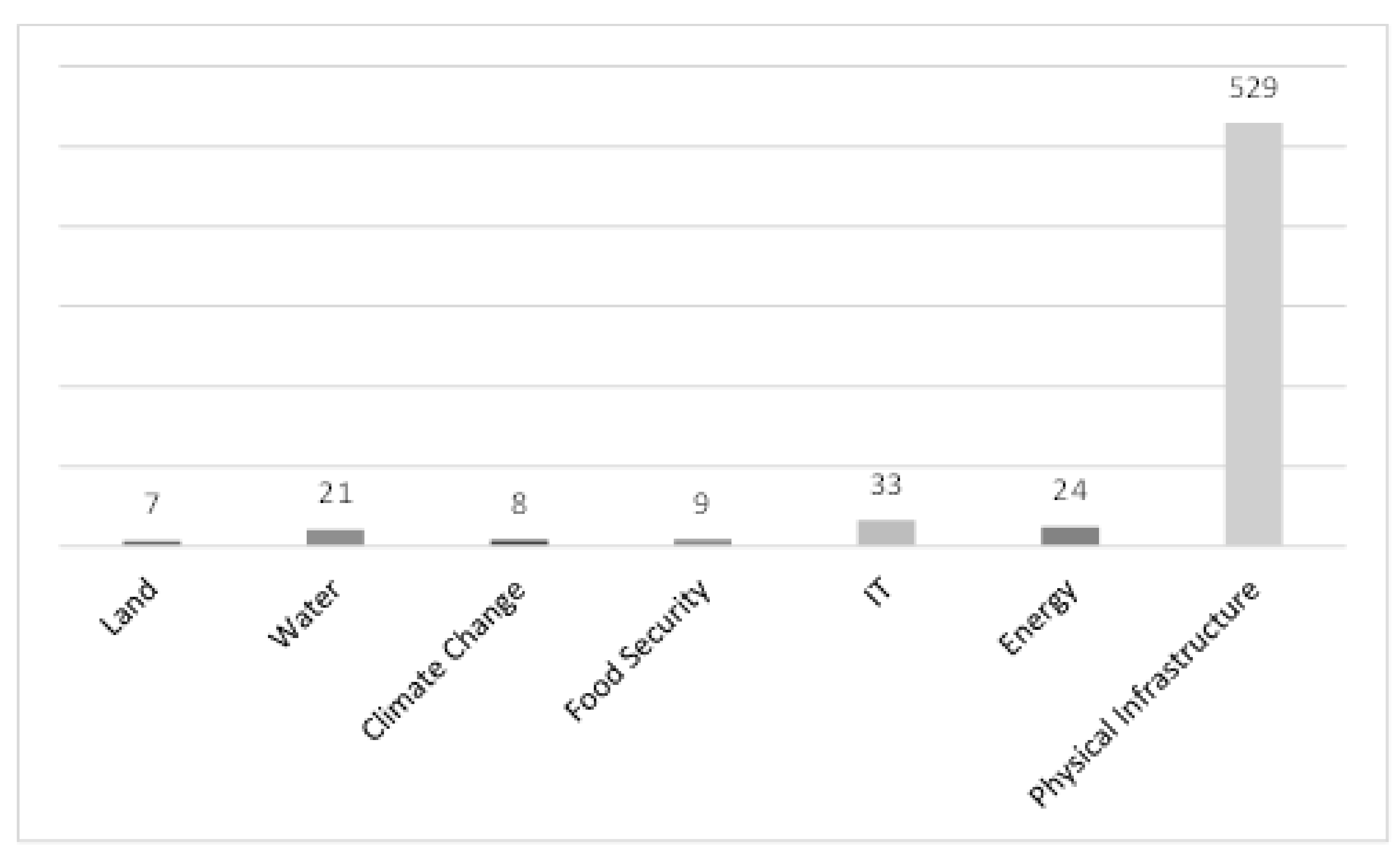
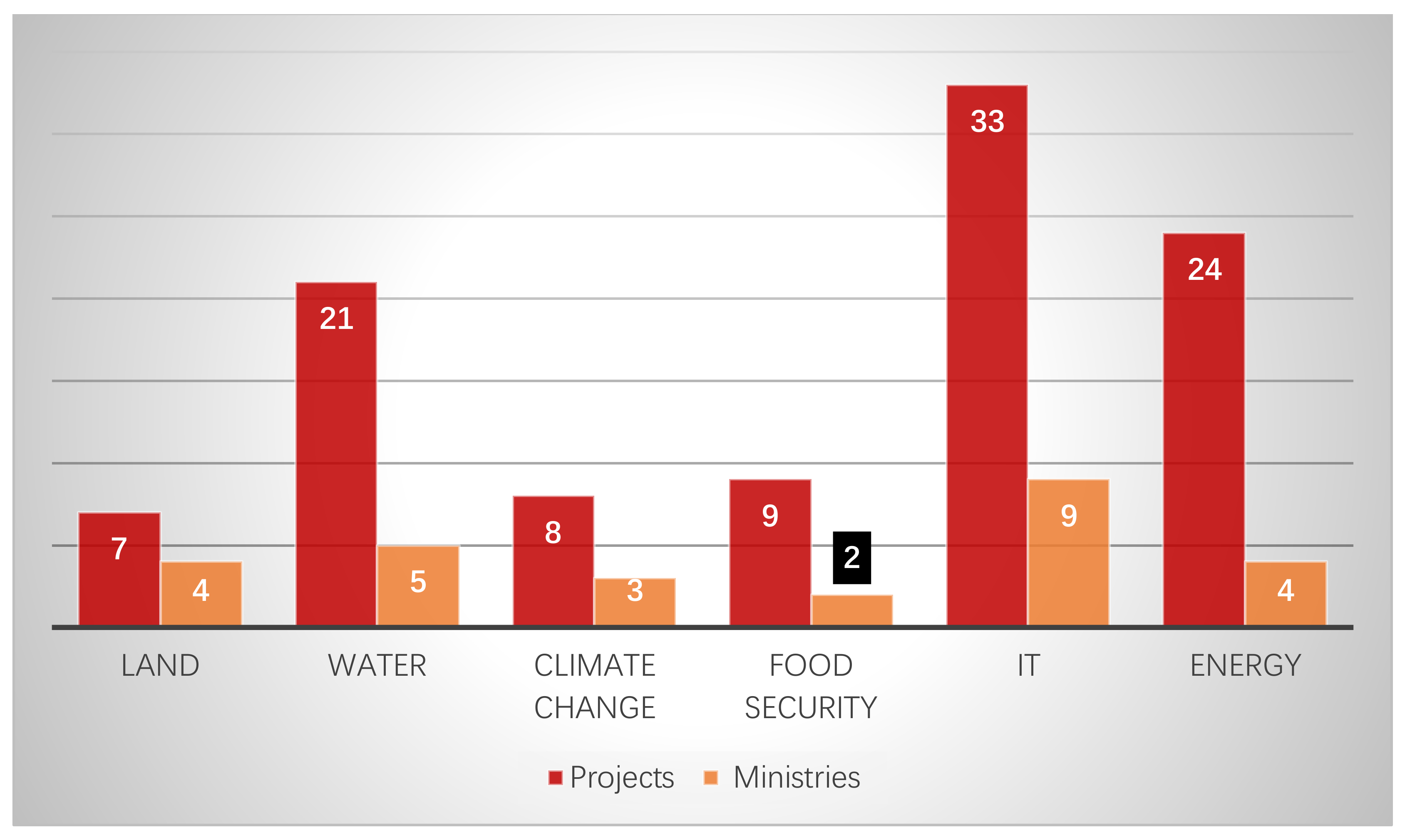
| Initiative | Phase | Scope of Work | Budget | Timeline |
|---|---|---|---|---|
| NSDI | 1-Feasibility study |
| Rs.90 Million | One year |
| 2-Implementation | It will be determined after phase-1 | Not yet decided | Not yet decided |
| Project Name | Concerned Ministry |
|---|---|
| Updating Agro Ecological Zones of Pakistan through Satellite and In-situ Data Mapping | National Food Security and Research |
| Establishment of National Spatial Data Infrastructure | Defense |
| Geospatial Monitoring of Major and High Value Crops | National Food Security and Research |
| Mapping of Historical and Religious Sites in Pakistan | National heritage and Culture |
| Geological Mapping of 50 Topo sheets of Balochistan | Petroleum |
| Cadastral Mapping | Planning, Development, and Special Initiatives |
| Pakistan Satellite Navigation Program | SUPARCO |
| Sustainable Land Management Program to Combat Desertification of Pakistan | Climate Change |
| Ten Billion Trees Tsunami Program | Climate Change |
| Relocation of Utilities to New Islamabad International Airport | Communications |
| Land Acquisition and Resettlement for China-Pak Economic Corridor | Communications |
| Relocation of Utilities to Lahore Ring Road | Communications |
| Pilot Project DTMB-A-Digitization of Terrestrial Network of PTV (Chinese Grant in Aid) | Higher Education Commission |
| Land Revenue Records Management System in Rural Area of ICT Phase-II, Islamabad | Science and Technological Research |
| National Center for Internet of Things | Information Technology and Telecom |
| Enterprise Resource Planning System | Power |
| Irrigation System Rehabilitation Project Punjab | Water Resources |
| National Pesticide Residue Monitoring System in Pakistan | National Food Security and Research |
| Establishment of Food Security Information System | National Food Security and Research |
| Pakistan Single Window | Revenue |
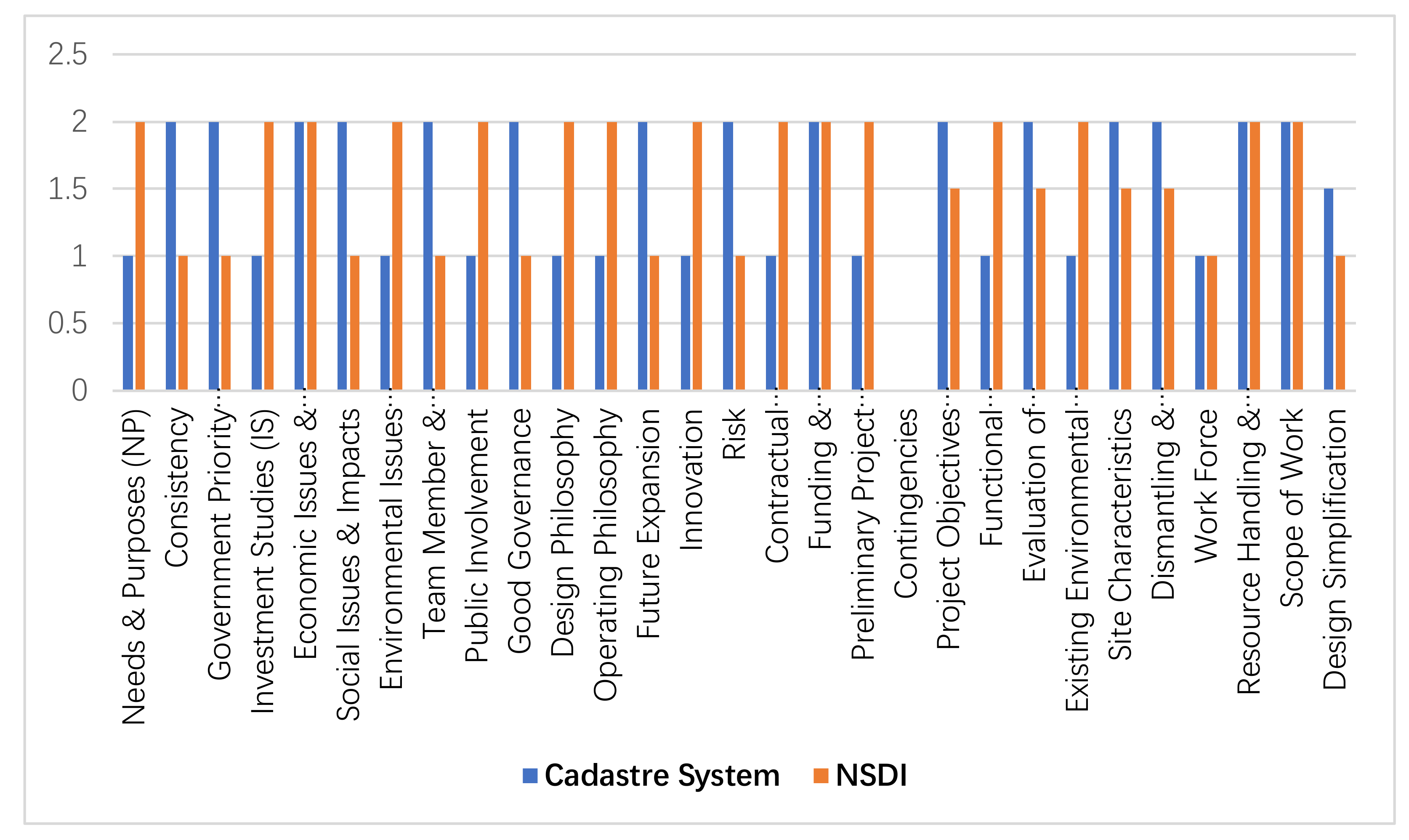
| Group | Decision Criteria | Cadastre System | NSDI |
|---|---|---|---|
| Group-I Strategic Fit (SF) This group comprises ten criteria and focuses on project issues. | 1. Needs and Purposes criterion analyzes the needs and purpose of a project in the light of its importance. | Economic development, to solve ongoing land disputes between people, and to stop and reclaim state land encroachment. | Economic development saves spatial data collection and management cost, and overcome duplication efforts for spatial data. |
| 2. Consistency criterion analyses the alignment of the project with national development goals and strategic defense aims. | The project perfectly aligns with SDGs adopted by the GoP. And large-scale data for security forces is also required for precise counter-terrorism activities. | The project is in accordance with e-Government initiative being implemented since 2005. | |
| 3. Government Priority criterion analyses the project’s importance regarding the national economy at national and regional levels. | The project is the priority of GoP. | It is important, but is not a priority of GoP. | |
| 4. Investment Studies criterion is related to the feasibility and other investment studies required during a project planning process. | Detailed and high resolution data of the project is extremely needed for “precision agriculture” [29] and economic development in Pakistan. | For evidence-based development planning, multiple spatio-temporal datasets are required, which can only be available through NSDI. | |
| 5. Economic Issues and Impacts: This criterion is concerned with examining the issues and effects of a project in relation to the economy. | The project would boost the construction industry of the country, and therefore, positively impact economic development. | The project would reduce duplication of financial resources, and therefore, would have a positive impact on the economy. | |
| 6. Social issues and impacts of the project. | Food security, poverty alleviation, and better housing facilities are all social issues faced by the country. The detailed project data would help to overcome these issues. | Social issues, such as clean drinking water, better housing, and health facilities require multiple datasets presently not accessible would become available through NSDI. | |
| 7. Environmental Issues and Impacts criterion focuses on the issues and impacts of the project concerning the environment. | This project will partially be useful to overcome environmental issues, such as the loss of green areas. | Pakistan faces various environmental issues, such as air pollution, loss of biodiversity, solid waste management, and climate change. Climate change is a crucial threat to Pakistan [30]. Twenty-two datasets were identified by [31] to combat climate change. NSDI would have a positive impact being a data-sharing initiative. | |
| 8. Team and Stakeholder Coordination criterion analyzes the coordination among the team members and stakeholders of the project. | Poor coordination has been observed among the stakeholders. | There is lack of coordination for NSDI development in Pakistan [32]. | |
| 9. Public Involvement criterion is concerned with the fact that how much the public is involved with the project and what is their attitude regarding the project. | Although the public is not involved in the project. Moreover, resistance from local governments does exist. | No direct involvement of the public, however, the representatives of various sectors are on board [33]. | |
| 10. Good Governance: This criterion analyzes the contribution of the project towards good governance. | The project outcome will contribute to achieving good governance as illegal land occupation is one of the critical causes of corruption in Pakistan. | The project outcome will contribute to achieving good governance. | |
| Group-II Owner Philosophies This group consists of seven criteria and focuses on the necessary information, which is needed to understand the project from the owner’s perspective. | 11. Design Philosophy criterion focuses on the design of the project to ensure its success. | The project is not well designed so far, due to the urgency of the GoP. | The project is well designed and in accordance with set norms of the planning commission. |
| 12. Operating Philosophy criterion examines the level of service, which is required at a sufficient capacity over an extended period. | SoP does not possess sufficient capacity to complete the project within one year. | SoP does possess sufficient capacity to carry out a feasibility study, but as per GoP’s rules, it has to be carried out by a third party. | |
| 13. Maintenance Philosophy criterion focuses on the maintenance of the project. | Not considered | Not considered | |
| 14. Future Expansion criterion is concerned with any possibility regarding the alteration or expansion of the project in the future. | The project is likely to expand after a successful pilot project. | No further expansion. | |
| 15. Innovation criterion assesses the innovation of the project. | The outcome will contribute to bringing innovation to the land market. | The outcome will contribute to bringing innovation to not only the land market, but also in many other sectors. | |
| 16. Risk criterion assesses the level of risk, which is involved with the project. | The highest risk is the limitation of time, i.e. one year. | No risk of time, however, being a long term project, changing priorities of the coming governments may hamper the project. | |
| 17. Contractual Conditions and Procurement criterion examines the conditions and models which the project takes into consideration. | Finalized, but guidelines to check the quality of outsourced work not yet ready. | Bit tough contractual conditions, such as at least one year of experience does exist in the ToRs. | |
| Group-IIIProject Funding and Timing This group comprises of three criteria dealing with the objectives of the project, which are related to the funding and timing constraints. | 18. Funding and Programming criterion deals with the funding and programming sources of the project. | No issue of funding as GoP is providing funds. | No issue of funding as GoP is providing funds. |
| 19. Preliminary Project Schedule criterion deals with the schedule of the project | Despite having a preliminary project schedule, achieving the set milestones could not be possible in the planned time frame. | Well planned schedule does exist; however, COVID-19 may impede achieving the set milestone. | |
| 20. Contingencies criterion is concerned with the contingencies in order to calculate the risks of the project. | No contingency plan to mitigate the project’s risks. | No contingency plan to mitigate the project’s risks. | |
| Group-IV Project Requirements This group comprises of ten criteria, which are concerned, with the requirements of the project. | 21. Project Objectives Statement criterion is concerned with the objectives of the project. | The project objectives are difficult to achieve, due to quite a short time period. | Almost all the objectives are achievable. |
| 22. Functional Classification and Use criterion is concerned with the functionality of the project, which would be either public or private. | The project is for public welfare and use. | The project is for public welfare and use. | |
| 23. Evaluation of Compliance criterion is used for analyzing the requirements of the project according to the existing plans, standards, and regulations. | The project will complement the existing plan of NSDI-Pakistan and Naya Pakistan Housing Program [34]. | Among others, the project will support the existing plan of E-Government, SDGs, and Pakistan single window [35]. | |
| 24. Existing Environmental Conditions criterion is concerned with examining the existing environmental conditions for the sake of making better decisions. | Poor existing environmental conditions. | Good existing environmental conditions. | |
| 25. Site Characteristics criterion analyzes the difference between the existing characteristics and required characteristics. | The site is good enough for the project. | There is a discrepancy between the available site characteristics and the required site characteristics. However, a separate office will be constructed. | |
| 26. Dismantling and Demolition criterion is concerned with the requirements, which are related to the dismantling and demolition of the project. | No such issue of dismantling and demolition. | Presently no issue, but the implementation stage may be problematic. | |
| 27. Determination of Utility Impacts criterion analyzes the adjustment of the utilities for the designing and construction of the project. | Not considered | Not considered | |
| 28. Work Force criterion analyzes the work force needed for the project. | Not sufficient work force is available in the department. | Not sufficient trained work force is available in the department. | |
| 29. Resource Handling and Utilization criterion is concerned with the handling and utilizing the resources for the project. | The available human and technical resources are being utilized properly. | The available human and technical resources are being utilized properly. | |
| 30. Scope of Work criterion examines the scope of work of the project. | Well defined scope of work. | Well defined scope of work. | |
| Group-V Value Engineering This group consists of four criteria, which examine the function of the project to enhance its value. | 31. Value Engineering Procedures criterion analyzes the project for consisting of value engineering procedures. | Not considered | Not considered |
| 32. Design Simplification criterion focuses on simplifying the design of the project. | The specifications of the project design could not be well defined, due to time limitations. | Will be determined after a feasibility study. | |
| 33. Material Alternatives criterion focuses on alternatives materials to use in the project. | Not considered | Not considered | |
| 34. Constructability Procedures criterion is concerned with the construction constraints of the project. | Not considered | Not considered |
Publisher’s Note: MDPI stays neutral with regard to jurisdictional claims in published maps and institutional affiliations. |
© 2021 by the authors. Licensee MDPI, Basel, Switzerland. This article is an open access article distributed under the terms and conditions of the Creative Commons Attribution (CC BY) license (http://creativecommons.org/licenses/by/4.0/).
Share and Cite
Ali, A.; Imran, M. National Spatial Data Infrastructure vs Cadastre System for Economic Development: Evidence from Pakistan. Land 2021, 10, 188. https://doi.org/10.3390/land10020188
Ali A, Imran M. National Spatial Data Infrastructure vs Cadastre System for Economic Development: Evidence from Pakistan. Land. 2021; 10(2):188. https://doi.org/10.3390/land10020188
Chicago/Turabian StyleAli, Asmat, and Muhammad Imran. 2021. "National Spatial Data Infrastructure vs Cadastre System for Economic Development: Evidence from Pakistan" Land 10, no. 2: 188. https://doi.org/10.3390/land10020188
APA StyleAli, A., & Imran, M. (2021). National Spatial Data Infrastructure vs Cadastre System for Economic Development: Evidence from Pakistan. Land, 10(2), 188. https://doi.org/10.3390/land10020188